Trewartha Creek Conservation Reserve Management Statement
This document provides policy direction for the protection, development and management of the Trewartha Creek Conservation Reserve and its resources.
Statement of Conservation Interest
Ministry of Natural Resources
Thunder Bay District
November 2001
W. Pamela Whyte
Resource Manager - Information Management
Thunder Bay
Approval statement
I am pleased to approve this Statement of Conservation Interest for the Trewartha Creek Conservation Reserve.
This Statement of Conservation Interest provides guidance for the management of the Conservation Reserve and the basis for the ongoing monitoring activities. More detailed direction is not anticipated at this time. Should significant facility development be considered or complex issues arise requiring additional studies, more defined management direction, or special protection measures, a more detailed Conservation Reserve Management Plan will be prepared with full public consultation.
The public was widely consulted during the designation and regulation of the site and further consultation is not required at this time.
The Conservation Reserve will be managed under the jurisdiction of the Shebandowan Area Team, Thunder Bay District, of the Ministry of Natural Resources.
Signed by:
W. D. Baker
Di strict Manager
Thunder Bay District
Date: November 20, 2002
Signed by:
Charlie Lauer
Regional Director
Northwest Region
Date: December 20, 2002
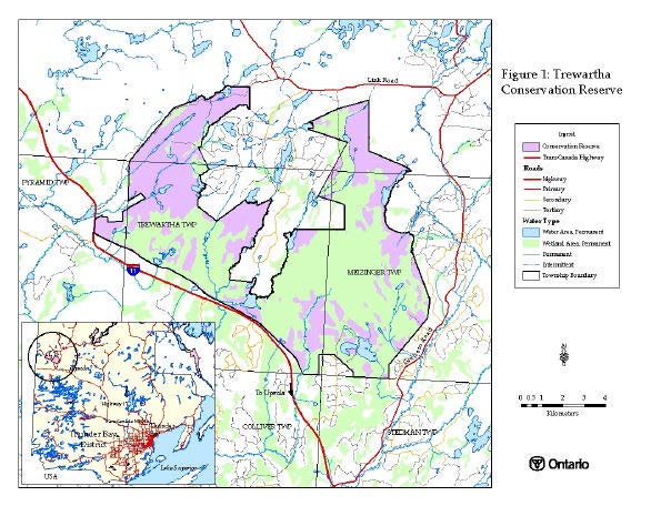
1.0 Map overview
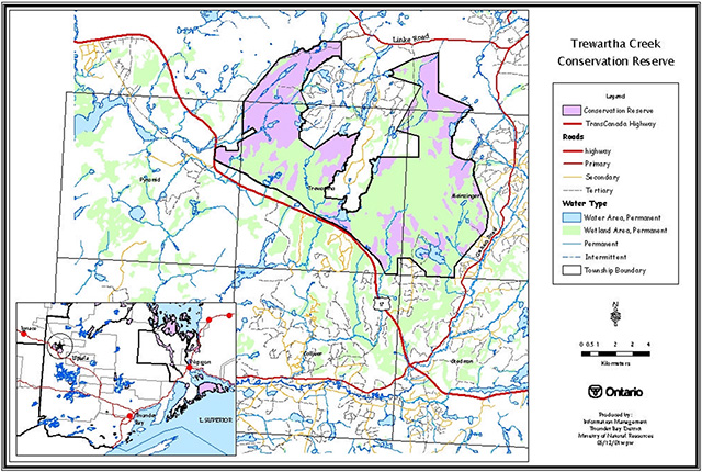
2.0 Background information
The purpose of this document is to identify the natural heritage values of Trewartha Creek Conservation Reserve, the activities that occur there now, and the activities that will be permitted in the future. This document also provides the management direction until more comprehensive planning occurs. The intent of this Statement of Conservation Interest is to protect values by establishing management guidelines for existing and potential uses in this area given the level of past disturbance and the nature of the existing features.
2.1 Background information
| Name | Trewartha Creek Conservation Reserve |
|---|---|
| Site Region / Site District | 3W2 |
| OMNR Administrative Region/District/Area | Northwest Region/Thunder Bay District/Shebandowan Area |
| Total area (ha) | 8,762 hectares |
| Regulation date | 2002 |
| First Nations | Treaty 3 Area – Lac Des Milles Lacs First Nation |
| OBM | 2015650054500, 2015660054500, 2015670054500, 2015670054400, 2015660054400, 2015650054400 |
| Latitude/longitude | 49.1683 / 90.7893 |
| Basemap | 65545, 66545, 67545, 67544, 66544, 65544 |
| Forest Resource Inventory | Located within the Dog River-Matawin Sustainable Forest License. 1976 FRI. |
| General location description | Trewartha Creek Conservation Reserve is located in approximately 150 km from the City of Thunder Bay and 20 km from the town of Upsula along highway 17. It is contained in parts of Pyramid, Trewartha and Meizinger Townships. |
| Access | Access to this conservation reserve is limited to non-maintained former cut roads that cross the boundary of this site and also by the railway corridor. |
2.2 Representation targets
This section provides a summary of the earth science, life science and cultural values represented in the site. Existing and potential recreational opportunities are also summarized.
| Life Science Representation | The wetland vegetation is composed of 11% swamp, 53% bog, 31% fen and 4% marsh. The conservation reserve includes a full spectrum of peatland communities. |
|---|---|
| Earth Science Representation | Weakly broken beach and aeolian deposits as well as weakly broken outwash deposits. |
| Cultural Resource Representation | There are no cultural values identified for this site. First Nation consultation may reveal values associated with this site. |
| Recreational Opportunities | Hunting, Wildlife viewing and appreciation. |
2.3 Survey information
This section provides an overview of the inventories completed their level of detail, and any further inventories that are needed.
| Survey level | Completed | Future requirements |
|---|---|---|
| Life Science | Reconnaissance Level Survey 2001 Northern Bioscience Ltd. | Detailed Life Science Inventory of Meizinger and Trewartha Bogs. |
| Earth Science | Reconnaissance Level Survey 2001 Northern Bioscence Ltd. | None. |
| Cultural | Confirmed with Ministry of Culture, Recreation and Citizenship (2001) – Bill Ross, Regional Archeologist. | Aboriginal Consultation |
| Recreational | Recreation Inventory Assessment completed December 2001. Pamela Whyte | Ongoing monitoring for recreational impacts. |
3.0 Values to be protected
This section provides a description of the key natural heritage values on the site, and their condition relative to past resource use and management activities and their sensitivity to future land use and management activities.
3.1 Values identified for protection on the site
3.1.1 Wetland values
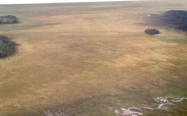
Trewartha Conservation Reserve includes two identified bogs, the Trewartha and Meizinger bogs. The majority of this site is a patterned peatland including many wetland types. While there currently appears to be no impacts of human influence on the wetland complexes, the peat land relies upon, and is sensitive to any changes to the local water regime. The vegetation communities found here are habitat to a more limited diversity of flora and fauna than that found in a mineral ecosystem however, some significant species and communities that have been located on the site.
3.1.2 Wildlife
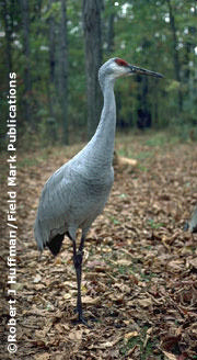
Rare species for site region 3W have been identified on the site during site visits. The sandhill crane, sharp-tailed grouse, greater yellowlegs and LeConte’s sparrows are all regionally rare nesting species in Site Region 3W.
Large game and upland bird species are currently hunted within and adjacent to the conservation reserve, with no noticeable impacts to wildlife diversity (i.e. rare species remain, bear hunt is under quota…).
Beaver, mink, otter, fisher, linx, muskrat, weasel, and coloured fox exist and are trapped on the five active traplines.
3.1.3 Earth science values
The area is rich in beach and aeolian deposits and also outwash deposits. While the entire site has been placed in interim protection and withdrawn from prospecting, staking out, sale or lease, the conservation reserve has mining claims adjacent to it.
3.1.4 Forest values
Black spruce dominated conifer swamp makes up about 10% of the peatland, typically at the margins of the open wetland where there is exposure to nutrient-rich ground water from the surrounding uplands. Besides within the peatland, the remainder of the conservation reserve is dominated by jack pine forest and mixedwood forest with birch, trembling aspen, jack pine, and balsam fir on sandy outwash soils. Some logging has taken place in upland portions of the northwest arm and also in southwest corner. Forest operations have also, and are currently, taking place adjacent to this site. The sites that have been subject to forest management operations are in a regeneration stage.
3.2 Values map
4.0 Management guidelines
4.1 Land tenure and candidate acquisition
Trewartha Creek Conservation Reserve consists entirely of Crown Land. Lands owned by the Ministry of Transportation, the Canadian Pacific Railway, and other Crown Land delineates the boundary of the conservation reserve.
- No dispositions (including Land Use Permits, Leases or Licenses of Occupation) will be issued for the site for industrial purposes
- Permitted uses may be authorized by land use occupational authority excluding sale or lease
4.1.1 Potential additions
Should the results of a detailed earth science report reveal parts of either the Meizinger and/or the Trewartha Bogs to be outside of the conservation reserve and on crown land, these parts should be added to the conservation reserve.
4.2 Existing and proposed development
At present time, there is only informal access to the conservation reserve. Access is either by four- wheel drive vehicle, ATV, snowmobile or by foot on former forest management roads or the CPR right-of-way. There are no existing campsites, privies, boat launches, parking lots, or waste disposal sites within the conservation reserve.
- New resource access roads within the mandate of Ministry of Natural Resources are not permitted
- Existing trails should be mapped and authorized.
- Trail development may be considered to enhance nature appreciation activities as long as it is determined that the new trail would not interfere with natural processes
- Non-trail use by motorized vehicle will only be permitted for the retrieval of game
- Campgrounds maybe considered following a test of compatibility
4.3 Recreational activities
Recreational activities that have traditionally been enjoyed in this area can continue provided they pose no threat to the natural ecosystems and features protected by the conservation reserve.
- Hunting and fishing activities will continue to be allowed as regulated uses by the Ministry of Natural Resources
- Non-regulated uses (i.e. ATV and snowmobile use) will be permitted as long as they do not adversely affect the values being protected. Effects of recreational use will be monitored on an on-going basis. Non-regulated uses may be reconsidered following any findings of negative impacts
- Camping is permitted within the conservation reserve
4.4 Commercial activities
No other commercial activities such as hydroelectric power development, new transmission lines (e.g. power or communications), pipelines, highways or roads, and the extraction of aggregate will be permitted.
4.4.1 Forest management activities
The Trewartha Creek Conservation Reserve is located within the Dog River-Matawin Forest and has been withdrawn from the Sustainable Forest License currently held by Bowater.
- Forest Management Activities are not permitted within the conservation reserve
4.4.2 Commercial trapping activities
Current trapping activities will be permitted to continue, unless there are significant demonstrated conflicts.
- New operations can be considered subject to "the test of compatibility" as outlined in the policies for conservation reserves (PL 03.05)
- There are currently no trapper cabins located within the reserve. No new cabins will be considered
4.4.3 Bear management activities
Bear hunting operations, as they are now, may continue in this conservation reserve.
- No new operations will be permitted
- The transfer of licenses will not be permitted and lapsed licenses will not be renewed
4.4.4 Commercial baitfish activities
Existing use will be permitted to continue, unless there are significant demonstrated conflicts.
- New operations may be considered and are subject to a test of compatibility
4.4.5 Mining exploration and peat extraction activities
- Careful mining exploration may occur in specific new conservation reserves proposed through the Ontario Living Legacy Land Use Strategy, in areas that have provincially significant mineral potential. If a portion of the new conservation reserve is to be developed for a mine, it would be removed from the reserve, and appropriate lands would be placed in regulation
4.4.6 Peat Extraction activities
Peat Extraction is not permitted within the conservation reserve.
4.5 Aboriginal interests
Trewartha Conservation Reserve is included in the Treaty 3 Area and is included in the Lac Des Milles Lacs Traditional Use Area. There are no known aboriginal interests within Trewartha Creek Conservation Reserve. This Statement of Conservation Interest in no way affects any existing or future aboriginal or treaty rights.
4.6 Natural Resources Stewardship
Natural Resource Stewardship involves the consideration of the following specific natural resource management categories.
4.6.1 Vegetation management
The conservation reserve includes a full spectrum of peatland communities. Upland forests are relatively uniform. Management within the conservation reserve will allow for the continuation of natural ecosystem processes and functions with minimal human interference.
- The Forest in the entire area is to be protected from any human alteration and forest fire protection will be carried out on the conservation reserve as on surrounding public lands but with a "light on lands" approach (i.e. no bulldozers, no camp construction, minimal tree cutting)
- Forest insect and disease management will continue as on surrounding crown lands
4.6.2 Fish and wildlife management
Rare species for site region 3W have been identified within the boundaries of the conservation reserve. Sport Hunting and fishing will be allowed to continue within the conservation reserve.
- Nuisance animals will be dealt with on a case-by-case basis
- Although no significant fish habitats have been identified in the conservation reserve. Should new information be found, fish management policies may be added as an amendment to this statement of conservation interest
- All other management decisions and changes to the management direction will have regard for rare species found within Trewartha Creek Conservation Reserve
4.6.3 Landforms
There are no significant or important landforms requiring supplementary protection. Management guidelines will protect landforms that are represented within the conservation reserve.
4.8 Client services and marketing
Given the focus on low key management, client information will be given on an inquiry basis only and will deal with basic level of information with respect to access, natural heritage appreciation, recommended activities and boundaries. A fact sheet has been prepared and will be given on an inquiry basis only. The pre-consultation fact sheet is also readily available on the Ministry of Natural Resources Internet Site.
4.9 Research and education
Non-destructive research related to the inherent values of this site will be encouraged. The peatland, the principle feature in this conservation reserve, may provide some interest for naturalists relative to the rare flora and fauna found there. Educational activities will be encouraged provided that they are consistent with the protection of values of the reserve.
- A detailed life science inventory should be completed within 5 years to verify the geographic extent of the Trewartha and Meizinger Bogs
- A more detailed study of the Pleistocene deposits and bedrock structure surrounding the peatland may reveal further details of its formation
- Aquatic surveys should be completed for the lakes, rivers and streams found within the conservation reserve boundaries. Identification of important fish habitat
- A winter recreational survey should be completed for the site
All research will require the approval of the Ministry of Natural Resources as will the removal of any natural or cultural specimen.
- No permanent fixtures on the landscape will be permitted without the approval of the Ministry of Natural Resources
- It is the responsibility of the researcher or research group to rehabilitate as closely as possible to its previous state
5.0 Implementation
These management guidelines are to be implemented by the Shebandowan Area Team, Thunder Bay District. Any affected clients will be immediately informed of proposed changes to this Statement of Conservation Interest.
- The environmental impact of recreational and resource development (on adjacent lands) on the areas more sensitive features (peat, wetlands), should be monitored on an ongoing basis
- Additional information should be gathered for this site as described in section 9: Research and education
Any new information and discovery of negative impacts should result in amendments to this statement of conservation interest as mitigative measures or the initiation of a resource management plan for this conservation reserve.
5.1 Review and revisions
The Trewartha Creek Conservation Reserve Statement of Conservation Interest will be reviewed on an ongoing basis.
If changes in management direction are needed at any time, the significance of the changes will be evaluated. Any major amendments will require public consultation and the approval of the District Manager and the Regional Director. This Statement of Conservation Interest complies with all requirements of the Environmental Assessment Act and the Environmental Bill of Rights.
5.2 Public consultation
5.2.1 Results of past consultation
Consultation occurred for one month in June and July of 2001. Stakeholders contacted during the consultation period included adjacent landowners, claim holders, local clubs, organizations, tourist operators and outfitters, baitfish harvesters and trappers and relevant provincial ministries. There were no concerns about Trewartha Creek Conservation Reserve.
5.2.2 Aboriginal consultation
Trewartha Creek Conservation Reserve lies within Treaty 3 treaty area. The Northwest Regional Office of the Ministry of Natural Resources has hired an aboriginal liaison, to deal specifically with Treaty 3 First Nations. It is not known if Treaty 3 supports or opposes the management of this site as a conservation reserve.
5.2.2 Future consultation
Future consultation may occur should policies affecting the activities in the conservation reserve be changed.
5.2.3 Authors
This Statement of Conservation Interest was prepared by Pamela Whyte, Resource Manager – Thunder Bay District.
6.0 References
Lake Superior First Nations Development Trust (Jan 1998) Lac Des Mille Lacs First Nation Traditional and Contemporary Values.
Ministry of Natural Resources. Conservation Reserves Policy and Procedure. PL 3.03.05. 1997. Activities/Use policies in Conservation Reserves (April 2000)
Ministry of Natural Resources (2001) NRVIS – Natural Resources Values Information System. Thunder Bay District, Thunder Bay, ON
Ministry of Natural Resources (July 1999) Ontario Living Legacy – Land Use Strategy Queens Printer for Ontario.
Northern Bioscience Ltd. (2001) Earth Science Inventory – Trewartha Creek Conservation Reserve. Thunder Bay, ON
Northern Bioscience Ltd. (2001) Life Science Inventory – Trewartha Creek Conservation Reserve. Thunder Bay, ON
Provincial Policy Statement (1996)
Ross, Bill (2001) Regional Archeologist, Cultural and Aboriginal Values, Northwest-Central Region, Ministry of Culture, Recreational and Citizenship. Thunder Bay, ON.
The Proctor and Redfern Group (1984) Peat and Peatland Evaluation of the Ignace area, Volume I of VI, Ontario Geological Survey Open File Report 5487, p. 209
Whyte, Pamela, (2001) Trewartha Creek Conservation Reserve Recreation Resource Assessment, Thunder Bay District, Ontario Ministry of Natural Resources.
Appendix I: Revised Policy Report
Adobe Acrobat Document [embedded document not included]
Appendix II: Trewartha Creek Conservation Reserve Recreation Inventory Report
Trewartha Creek Conservation Reserve
C2285
Recreation Inventory Report
September 2001
Prepared for OMNR – Northwest Region
Pamela Whyte
Thunder Bay District
2001
1.0 Introduction
This Report constitutes a summary of background information and fieldwork pertaining to the recreational resource inventory conducted for the proposed Trewartha Creek Conservation Reserve. This report is intended for internal use as background information for future planning and management decisions regarding Trewartha Creek Conservation Reserve.
A recreational resource assessment was conducted for the proposed conservation reserve in order to:
- determine the significant biophysical features which support recreation
- determine the existing and potential recreational uses of the conservation reserve
- determine the environmental impacts associated with recreational use
- determine the variety of human influences and land uses in the conservation reserve
2.0 Site description
The proposed Trewartha Creek Conservation Reserve is composed of upland mixed coniferous and deciduous forests, peatland communities, open wetlands and lakes. Trewartha Conservation Reserve is located within the unorganized townships of Pyramid (most westerly), Trewartha, and Meizinger. The site is approximately 150 km from Thunder Bay one the north side of Highway 17. The closest community, Upsula, is 20 km southeast of the site.
The majority of the area was previously designated as the Trewartha Peatlands ANSI (Area of Natural and Scientific Interest). ANSI's are areas of land and water containing natural landscapes or features which have been identified as having values related to the protection, natural heritage appreciation, scientific study or education. As described in the ANSI report, "The Trewartha ANSI is a large patterned peatland complex comprising several wetland types. Several regionally rare plant species occur within the ANSI which are unknown to grow elsewhere in north western Ontario." In addition to plants, Sandhill Cranes have been seen and observed during field visits and may be using the peatland as a staging or possible nesting area.
For more information on the earth and life science features represented in this site, the earth and life science checksheets prepared by Northern Bioscience Ltd. should be consulted (Fall 2001).
No cultural values are known to exist at this site.
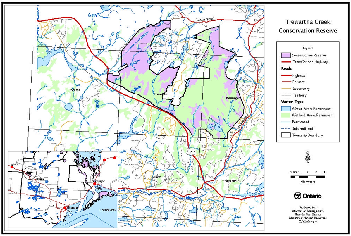
3.0 Map overview
4.0 Methodology
Two methods of research were carried out to complete this recreation inventory. Primary research and information consisted of field visits and discussion with district staff including, area technicians, biologists, and conservation officers responsible for the management of this area. The consultation of internal records and documents was considered secondary information. The secondary research was conducted prior to any site visits and guided the exploration of the site. The subsequent exploration of the site in turn initiated further questions that were answered back at the district office.
Table 1. Summary of Information Sources
| Primary research | Secondary research |
|---|---|
| Discussions with conservation officers, area biologists, area technicians, resource management clerks and consultants performing reconnaissance earth and life science inventories. | NRVIS Values |
| Site Visits June15th, 2001 – by helicopter August 9th, 2001 – by road August 16th, 2001 – by road and bike. September 4 th, 2001 – by foot |
Baitfish Permits Bear Management Records Trapper Records (FRMIS) |
| Land Use Permit Records | |
| OBM, FRI, OLL Boundary Maps | |
| 1996 Aerial Photography | |
| Canadian Land Inventory Data |
Two visits were made to the Trewartha Creek Conservation Reserve to determine access and recreational opportunities for the site. Access was attempted by three means 1) in a vehicle (2wd as well as 4x4), 2) by bicycle and finally 3) by foot. It was determined that the site has very little vehicular access (via the railroad or by a cutover on the southwest corner of the site. Access could be made on foot on old forest management roads however, some of these have grown in quite substantially and ease of access may be questionable.
The Thunder Bay District Planner and consultants also made a site visit for the purpose completing reconnaissance earth and life science inventories. The information from their visit is incorporated into this report. The consultants previously visited the site between 1994 and 1998. Winter access has been suggested also by the consultants. Winter activities and access has not yet been determined at this point.
5.0 Recreational features
Recreation features are biophysical and cultural features that provide opportunity for recreation within the conservation reserve. Features were selected from a list included in the Ontario’s Living Legacy Guidelines for Recreation Resource Assessment, Version 2 – April 2001. A total of three features were identified at Trewartha Creek Conservation Reserve as providing recreational opportunities. The features are ranked according to their potential for providing recreational opportunities. The first entry has the highest recreation value or the greatest recreation importance. Recreation features were also evaluated based on attraction capability, scenic attractiveness, geographic significance, and feature sensitivity. This information will be entered into the Recreation Inventory Checklist (Appendix A) which will be used to meet the provincial direction of creating a recreation inventory for recreation in parks and protected areas in Ontario. The following sections provide more detail on each of the features.
5.1 Wildlife diversity (W05)
Large and small, aquatic and terrestrial animals, birds and fish can be seen at Trewartha Creek Conservation Reserve.
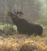
Moose, meaning "eater of twigs," are found in wooded areas in North America. Their long legs enable them to both browse on low brushes and small trees and wade in lakes and ponds to feed on aquatic plants. Trewartha Creek Conservation reserve is a natural habitat for moose in both the summer and winter seasons. During the fall, moose feed on the previous year’s growth of aspen, willow, birch, hazel, dogwood and balsam fir, which are all found in the area. The conservation reserve is a complex of wetlands and small inland lakes supporting aquatic vegetation, which makes up the mooses' nutrient needs in the summer. The area also borders the TransCanada highway. Being partially salted in the winter the area provides salt deposits for the moose to lick in the spring.
Sandhill Cranes are birds of open country, and therefore like the freshwater wetlands found within Trewartha Creek Conservation Reserve. They also live in shallow marshes and wet meadows. The nests in the wetlands are usually built of the vegetation that is found there. Much of crane staging areas in North America have been lost due to human intervention such as irrigation and hydroelectric development which tends to drain wetlands and promote the growth woody material which is a major threat to the crane population. Trewartha Creek Conservation Reserve is an important location to help maintain crane populations since they are already staging there. Cranes are opportunistic omnivores. The majority of the crane diet is not fish but a wide variety of plants and animals.
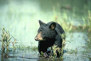
Relatively inaccessible terrain, thick understory vegetation, and abundant sources of food characterize prime black bear habitat. Small, thick swampy areas provide excellent refuge cover. Important non- forested areas include wet meadows, riparian areas, roadsides, and burns, all found within the boundaries of Trewartha Creek Conservation Reserve.
Upland and other migratory birds as well as other small terrestrial and aquatic mammals can also be found making their home within the boundary of Trewartha Creek Conservation Reserve. Trapper reports indicate that marten, beaver, mink, otter, lynx, muskrat, red squirrel, weasel and colored fox have been trapped in this area.
5.2 Organic materials (J05)/(E00) vegetation features
Trewartha Conservation Reserve is a large patterned peatland complex made up of several different wetland types. Trewartha Conservation reserve is formed on a glacial outwash basin of sand and till. It is surrounded by highlands to the north, west and southwest dipping and draining to the south. It is linked by drainageways to other peatlands to the south and east. The wetland complex has been identified, as being 70% bog and the remainder is fen – only 10% of the wetland complex site is considered tree covered with the dominant species being black spruce and/or tamarack. The majority of the site is open, low shrub.
Fuel grade peat was found within the extent of the peatland, but according to the report, it is of poor quality and the large amount of surface water present at the site would make extraction difficult.
The sites' importance would be damaged with any change to the water regime, which could cause changes to the natural processes within its ecosystem and it connectivity to other ecosystems.
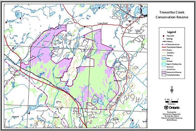
Trewartha Creek Conservation Reserve Water map
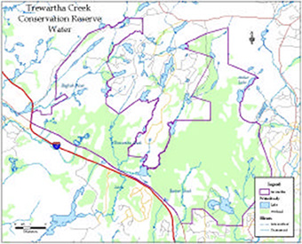
5.3 Waterbodies (M00)
Trewartha Creek Conservation Reserve encompasses a wide variety of types of waterbodies, including wetlands, small streams and rivers and small and mid-sized lakes. The only named lake found within the boundary of this new conservation reserve is known as Antler Lake. Named rivers crossing the reserve are the English River, Little Trewartha River and Beaver River. A large area of the reserve is classified as wetland. The combination of these waterbody types creates interesting aquatic habitat making it home to many flora and fauna and an environment for the formation of peat.
6.0 Recreational activities
The recreational activities described below are a combination of existing recreational activities and the potential recreational activities within Trewartha Creek Conservation Reserve. The recreational activities are closely related to the recreational features, although there is not necessarily a direct correlation, as one feature may have potential to support a wide variety of recreational activities that may not be currently taking place within the reserve area. During the recreational inventory, four recreational activities were recorded and ranked on the Recreational Inventory Checklist (Appendix A). Activities were selected from a list included in the Ontairo’s Living Legacy Guidelines for Recreation Resource Assessment, Version 2 (April 2001). Existing activities were differentiated from potential activities by using a capital letter in the activity code. The following sections provide more detail on each of the features and are organized by their rankings, and listed by activity and code.
6.1 Wildlife viewing (Q09)
The mixture of wetland and upland landscapes affords recreationalists the opportunity to catch a glimpse of numerous natural features found in the area. The area has created habitat for numerous plants and animal species such as those mentioned in the recreational features section 5.1 wildlife diversity. The Thunder Bay Field Naturalists take annual fall trips to the area to view two sharp-tailed grouse leks in their courtship display grounds.
6.2 Hunting – general (H00)
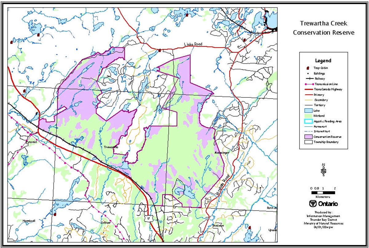
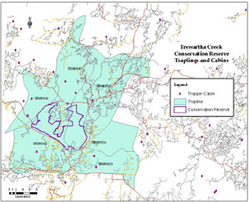
Hunting activities, particularly for black bear are known to exist in the area. Five Bear Management Areas exist in and around the area itself. While bear camps were not found within the boundary of the reserve, they are found adjacent to the boundary that is most likely using crown land for hunting. The conservation reserve also has Records from past hunts (1998-2001) indicating the harvesting of bears below quota for the area. The conservation reserve lands are also contained in six traplines. Records from those registered traplines indicate active trapping of numerous small and medium sized mammals (i.e. red squirrel, otter, lynx).
Trewartha Creek Conservation Reserve Traplines and Cabins
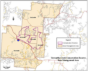
Trewartha Creek Conservation Reserve Bear Management Area
Blueberries
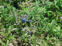
6.3 Berry picking (G02)
The Upsula area is well known for its blueberries. Short and high bush blueberries are found within and surrounding the reserve. Blueberries grow in acidic soils, in bogs and in marshes or on barren land. The area surrounding Trewartha Creek Conservation Reserve has been extensively harvested for timber for many years, which creates ideal conditions for blueberries in addition to the wetland complex found in the area. Numerous blueberry pickers were encountered during site visits to the proposed conservation reserve, however these areas observed, were outside of the reserve boundaries
6.4 Snowmobiling (D10)
Since all the fieldwork was conducted in the summer and fall months, it was difficult to determine the amount of snowmobile use in the area. The Thunder Bay Adventure Trails do follow highway 17 through Upsula and Trewartha Township. It is not known if snowmobile trails exist within the site.
7.0 Recreation factors
The recreational factors provide a context for the information collected during the recreation inventory, as they are meant to provide some insight on how the site will contribute to the outdoor recreation at the regional level.
7.1 Feature significance
Feature significance for the conservation reserve is measured by feature scarcity, uniqueness, activity attraction capability, scenic attractiveness, and geographic attractiveness. Feature significance was rated as moderate due to the fact that the conservation reserve is protected from exploration, while adjacent areas are being explored for peat production.
Feature scarcity is defined as the deficiency in the number of recreation features compared with the demand. Very little recreational value exists at Trewartha Creek Conservation Reserve. The area is almost entirely wetland and recreational potential is low to none. Feature scarcity is not applicable to this conservation reserve as the recreational use of the features is low to none.
The most unique feature that is found within this conservation reserve is its peatland communties. While common in the area, it is not across the district or region.
Activity attraction capability is the ability of the features or activities to attract recreational use. The unique combination of features, activities and setting will attract recreational use. Trewartha Creek Conservation Reserve has a very low capability to attract recreational use because the site is not easily accessed. While blueberry picking is a popular activity, it occurs mostly outside this area and is limited to the age of the cutovers, which will eventually grow to an age at which blueberries are no longer a complimentary species.
Scenic Attractiveness is a composite measure of the scenic attractiveness of the protected area. Trewartha Creek Conservation Reserve has low scenic attractiveness. While the occurrence of attractive plant and animal species may be moderate to high, the access to see such species is a challenge as no roads run through the site to give access to likely, the most used habitat.
Geographic Significance represents the importance of the recreational features and/or activities internationally, nationally, provincially, regionally, or at a community level. Trewartha Township Conservation Reserve has been previously designated as provincially significant ANSI for its life science value.
7.2 Feature sensitivity to recreation use/most sensitive feature to resource development
The feature most sensitive to recreational use is also the most sensitive to resource development, the vegetation communities found there. Peat extraction is not permitted in conservation reserves, however if this policy ever changed, several environmental impacts would occur to wetland functions and wildlife habitat. The protection of rare or protected species and the release of stored carbon and its impact on global warming will need to be examined.
The development of peatland will also create issues related to water quality, quantity and flow. Recreation activities can either preserve the natural condition of wetlands or be part of their destruction. Many activities such as hunting, fishing and bird watching are considered non-destructive. However, other recreational activities involving the construction of facilities are destructive to wetlands. It would be undesirable to allow any recreational activity that might disrupt the natural processes to occur at this site.
7.2 Cultural/historic and archeological features
The Trewartha Creek Conservation Reserve was rated as having no cultural/historic or archeological features following a consultation with the Regional Archeologist.
8.0 Recommendations
Upon completion of this first phase of the recreational assessment, a series of recommendations were made. The recommendations for the future use of this site are as follows.
8.1 Additional research
Field visits should be made during the winter months to confirm and document other activities, such as snowmobiling and ice fishing.
The environmental impact of recreational and resource development on the area’s more sensitive features (Peat, wetland), should be monitored on an ongoing basis. A detailed and life science report should be completed for the site to determine which parts maybe negatively affected by adjacent development activities.
Aquatic surveys should be completed for the lakes, rivers and streams found within the reserve boundaries. Identification of important fish habitat/spawning areas found within the reserve should be completed.
8.1 Future management
All hunt camps and trapper cabin’s located within, or in close proximity to the site, should be inspected on a more regular basis.
Care should be taken to ensure that all District staff’s is given access to the information contained in this report and that NRVIS values are periodically updated to reflect new information.
A statement of conservation interest will provide the management direction for this conservation reserve.
9.0 References
CanadianCanoeRoutes.com, canadiancanoeroutes.com 2001
Ministry of Natural Resources (1988) Trewartha Township Peatland: Area of Natural and Scientific Interest.
Ministry of Natural Resources (July 1999) Ontario’s Living Legacy Land Use Strategy Queens Printer for Ontario.
Mulrooney, Dan (April 2001) Ontario’s Living Legacy Guidelines for Recreational Resource Assessment Ministry of Natural Resources, Ontario Parks.
Natural Resources Canada Website (2001), The Value of Wetlands.
Natural Heritage Information Center http://www.mnr.gov.on.ca/MNR/nhic/nhic.htm. [Link no longer active] NHIC contains information on rare, threatened and endangered species and spaces in Ontario
North American Wetlands Conservation Council (Canada), (1992) Canadian Peat Harvesting and the Environment: Issues Paper, No.1992-3. Corporation Agreement on Mineral Development and Canadian Sphagnum Peat Moss.
Northern Bioscience Ltd. (2001) Trewartha Creek Conservation Reserve Earth Science Checksheet. Thunder Bay, ON.
Northern Bioscience Ltd. (2001) Trewartha Creek Conservation Reserve Life Science Checksheet. Thunder Bay, ON.
Natural Resources Values Information System Data Layers (2001).
Ross, Bill (2000) Regional Archeologist.
Appendix I: Recreation Inventory Checklist
Adobe Acrobat Document [embedded document not active]
Appendix III: Natural Heritage Area – Life Science Checksheet – Trewartha Creek
C2285 Trewartha Creek
Natural Heritage Area – Life Science Checksheet
| Name | C2285 Trewartha Creek |
|---|---|
| Map name | Firesteel River |
| Map number | 53G/12 |
| UTM reference | Zone 16 E 55600 N 558900 |
| County | Thunder Bay District |
| Latitude | 49°09' N |
| Longitude | 90°42' W |
| NAD | 83 |
| Minimum altitude | 457 m |
| Maximum altitude | 502 m |
| Locality | 25 km West of Upsala |
| Township | Trewartha, Meinzinger, Pyramid |
| Area | 9,745 ha |
| Ownership | Crown |
| MNR Region | Northwest |
| Ecoregion and ecodistrict | 3W-2 |
| Landform unit | See Table 4 |
| MNR District | Thunder Bay |
| Aerial photographs Year-Roll-Flight Line-Numbers |
19/4903B/12 19/4904B/66-68 19/4905B/121-122 19/4905/121 5/4907B/210-213 5/4908/125 5/4907/208-209 5/4906/160-163 |
Physical and biological features
Trewartha Creek Conservation Reserve contains one of the largest peatlands in Northwestern Ontario. About 80% of the Conservation Reserve lies on a sandy outwash plain; the remainder is aeolian deposits. Most of the site is covered with organic deposits.
The landscape of the Conservation Reserve is dominated by a large peatland with two arms, joined at the south end. The west arm is sometimes known as the Trewatha Peatland and the east arm is the Meinzinger Peatland.
Vegetation is a mosaic of raised bogs, water tracks, patterned fen, conifer swamp and small upland islands. The vegetation patterns indicate that water flows from north to south.
Patterned fen vegetation is found where the groundwater flow is greatest. Distinctive linear ridges and pools are evident on aerial photographs. Vegetation is dominated by sedges and low shrubs with plant indicators of mineral- rich conditions, including shrubby cinquefoil, starved sedge, livid sedge and Hudsonian club rush (ES43). Treed fen (ES40) with small widely spaced tamaracks dominates the edges of the main groundwater flow where nutrient availability is less and rich indicators decline. Open fen makes up about 25% of the peatland and treed fen about 4%.
Bog makes up over 50% of the peatland (about half open bog and half treed bog). Bogs occur as isolated bog "islands" surrounded by fen and more extensive areas at the edges of the water tracks where peat accumulation has raised the surface above contact with groundwater. Open bogs (ES39) are dominated by few-seeded sedge, ericaceous shrubs and Sphagnum mosses. Treed bog (ES34) has similar vegetation, but with scattered small black spruce trees. Treed bogs are found in somewhat drier sites, such as the crests of bog islands.
Black spruce dominated conifer swamp (ES35, ES36) makes up about 10% of the peatland, typically at the margins of the open wetland where there is exposure to nutrient-rich ground water from the surrounding uplands.
Peat depth averages 3.6 m in the west arm and 2.9 m in the east. The top layer half to two-thirds is poorly decomposed (fibric) peat over more well-decomposed (fibric-mesic).
The remainder of the Conservation Reserve is dominated by jack pine forest (ES13) and mixedwood forest with white birch, trembling aspen, jack pine, and balsam fir (ES14, ES16) on sandy outwash soils.
The Conservation Reserve contains over 20 small lakes and ponds, including Antler Lake. Lakes make up 4% of the site. A distinctive shallow marshy lake near the southwest side of the Conservation Reserve is actively in-filling with sedimentary peat. The peatland is the headwater of the English River. Three other small streams drain the peatland south into the Firesteel River.
A wild fire burned 154 ha on the Conservation Reserve in 1996, and 224 ha burned in the 1970s.
Representation
Trewartha Creek Conservation Reserve includes excellent representation of patterned rich fen, treed fen, open bog and treed bog. With over 4000 ha of more-or-less contiguous open peatland, it should provide adequate habitat for most area sensitive peatland species.
The landcover (Table 2) and landform- vegetation (Table 4) data include misclassifications of peatland vegetation. More accurate data is available in the Ontario Peatland Inventory (Table 1). (Proctor and Redfern Group 1984). Meinzinger and Trewartha Bogs (190 and 191) closely follow the conservation reserve boundaries. These data are derived from detailed groundwork and air photo interpretation.
Table 1. Wetland vegetation of the Trewartha Creek Conservation Reserve (Proctor and Redfern Group 1984).
| Vegetation type | Trewartha (ha) | Meinzinger (ha) | Total area (ha) | Percent |
|---|---|---|---|---|
| Conifer Swamp | 306 | 319 | 625 | 9 |
| Thicket Swamp | 11 | 113 | 124 | 2 |
| Total Swamp | 317 | 432 | 749 | 11 |
| Treed Low Shrub Bog | 319 | 1054 | 1373 | 21 |
| Treed Graminoid Bog | 233 | 72 | 305 | 5 |
| Open Low Shrub Bog | 272 | 1135 | 1407 | 21 |
| Open Graminoid Bog | 95 | 325 | 420 | 6 |
| Total Bog | 919 | 2586 | 3505 | 53 |
| Treed Tall Shrub Fen | 6 | 21 | 27 | 0 |
| Treed Low Shrub Fen | 7 | 257 | 264 | 4 |
| Treed Graminoid Fen | 0 | 29 | 29 | 0 |
| Open Shrub Rich Fen | 0 | 372 | 372 | 6 |
| Open Tall Shrub Fen | 103 | 96 | 199 | 3 |
| Open Low Shrub Fen | 26 | 282 | 308 | 5 |
| Open Graminoid Fen | 303 | 586 | 889 | 13 |
| Total Fen | 445 | 1643 | 2088 | 31 |
| Shrub Rich Marsh | 0 | 216 | 216 | 3 |
| Shallow Marsh | 33 | 10 | 43 | 1 |
| Total Marsh | 33 | 226 | 259 | 4 |
| Other | 0 | 42 | 42 | 1 |
| 1714 | 4929 | 6643 | 100 |
Condition
The interior of the peatland shows no evidence of human impacts and is almost never visited by people.
Four roads enter the Conservation reserve, two in the west arm at the north end, one off the Graham Road on the east, and one at the west end off Highway 17. Highway 17 and the rail line form part of the southern boundary.
Some logging has taken place in upland portions of the northwest arm (82 ha of cutover according to landcover data). Logging operations are active around the Conservation Reserve and between the two arms.
Peat mining has been proposed for the peatland in the past, but quality of peat was too low and the difficulties of drainage too great to make it a financially feasible operation. Mining is prohibited in Conservation Reserves, but mineral exploration may occur. Whether these rule apply to peat mining is unclear.
Diversity
The Conservation Reserve includes essentially the full spectrum of peatland communities. Upland forests and the terrain are relatively uniform.
Ecological considerations
The patterned fen community depends on groundwater flow from outside the Conservation Reserve. Land practices outside the Reserve that disrupt groundwater movement could impair hydrological processes. The hydrology of the peatland south of Highway 17 (outside the Conservation Reserve) was disrupted by road and rail line construction as is reflected in changes in the vegetation close to the road.
The southern edge of the Conservation Reserve follows Highway 17 and the rail line, posing the risk of spills, invasion of exotic plants, and fire originating from the rail line.
Special features
The rich patterned fen is globally rare community type according to Nature Conservancy rankings (G2). This ranking may be inaccurate given the abundance of the peatlands in northwestern Ontario and in the Hudson Bay Lowlands.
The fens at Trewartha Creek are nonetheless easily accessible, pristine examples of this boreal community type.
Marsh rush, a regionally rare plant, grows in the rich fen. This northern species is restricted to large, rich fens and very local in northwestern Ontario. Species found exclusively in rich fen habitats include twig rush (regionally rare), Michaux’s sedge, starved sedge, livid sedge, ragged orchis (regionally rare), yellow-eyed grass (regionally rare) and chokeberry (regionally rare). Most of these species are near the western edge of their range at Trewartha Creek.
Sandhill cranes are prominent in the nesting season. Nesting was confirmed in 1995 (Robert Foster, Allan Harris, Gerry Racey, pers. obs.). Two sharp-tailed grouse leks (courtship display grounds) were discovered by Nick Escott in open peatlands in the Conservation Reserve (Nick Escott, pers comm.). Up to 25 courting birds use each of these sites between mid-March and early May. Territorial pairs of Greater Yellowlegs are common near ponds. Although unconfirmed, they probably nest in the peatland. LeConte’s sparrows have been heard singing in sedges in open fen habitats.
Sandhill crane, sharp-tailed grouse, greater yellowlegs and LeConte’s sparrows are regionally rare nesting species in Site Region 3W.
Major information sources
Harris, A.G., S.C. McMurray, P.W.C. Uhlig, J.K. Jeglum, R.F. Foster and G.D. Racey. 1996. Field guide to the wetland ecosystem classification for northwestern Ontario. Ont. Min. Natur. Resour., Northwest Sci.&Technol. Thunder Bay, Ont. Field Guide FG-01. 74 pp. + Append.
OMNR. 1999. Ontario’s Living Legacy – Land Use Strategy. Queen’s Printer, Toronto.
Proctor and Redfern Group. 1984. Peat and peatland evaluation of the Ignace area. 6 Volumes. Ontario Geological Survey. Open File Report 5487.
Racey, G.D., A.G. Harris, J.K. Jeglum, R.F. Foster and G.M.Wickware. 1996. Terrestrial and wetland ecosites of northwestern Ontario. Ont. Min. Natur. Resour., Northwest Sci. & Technol. Thunder Bay, Ont. Field Guide FG-02. 88 pp. + Append.
Sims, R.A., W.D. Towill, K.A. Baldwin, P. Uhlig and G.M. Wickware. 1997. Field guide to the forested ecosystem classification for northwestern Ontario. Ont. Min. Natur. Resour., Northwest Sci. & Technol. Thunder Bay, Ont. Field Guide FG-03. 176 p.
Significance level
The Trewartha Creek Conservation Reserve includes a provincially significant peatland with a diversity of bog, fen and swamp communities. The rich patterned fen includes several regionally rare plants and birds that are restricted to peatland habitats.
Date Compiled: 06/06/02
Compiler(s): Allan Harris, Robert Foster, Northern Bioscience
Table 2. Land cover classes of Trewartha Creek (derived from Landsat data).
| Landcover Class | Area (ha) | % of Site |
|---|---|---|
| Water | 389 | 4 |
| Open Fen | 41 | 0 |
| Treed Fen | 1998 | 21 |
| Open Bog | 1763 | 18 |
| Treed Bog | 1956 | 20 |
| Dense Deciduous Forest | 347 | 4 |
| Dense Coniferous Forest | 1132 | 12 |
| Mixed Forest – mainly Deciduous | 715 | 7 |
| Mixed Forest – mainly Coniferous | 309 | 3 |
| Sparse Coniferous Forest | 277 | 3 |
| Sparse Deciduous Forest | 61 | 1 |
| Recent Cutovers | 82 | 1 |
| Recent Burns | 292 | 3 |
| Old Cuts and Burns | 377 | 4 |
| Settlement and Developed Land | 7 | 0 |
Table 3. Rapid assessment plot summary from Trewartha Creek.
| Plot No. | V/W Type | ES Type | Date |
|---|---|---|---|
| 196 | V37 | ES35 | 09/04/2001 |
| 192 | W17 | ES43 | 06/15/2001 |
| 191 | W25 | ES40 | 06/15/2001 |
| 197 | W23 | ES29 | 06/15/2001 |
| 195 | V33 | ES13 | 09/04/2001 |
| 193 | W18 | ES40 | 06/15/2001 |
Table 4. Landform - vegetation (LV) type representation for Trewartha Creek (ha).
| Site region | Landform | Surface expression | Burn | Conifer | Conifer mixed | Deciduous | Deciduous mixed | Open wetland |
|---|---|---|---|---|---|---|---|---|
| 3W-2 | Beach and Aeolian Deposits | weakly broken | 100R | 389 | 128 | 201 | 327 | 258 |
| Outwash Deposits | weakly broken | 534 | 600R | 123R | 30R | 142 | 3942C | |
| Grand Total | 634 | 989 | 251 | 231 | 469 | 4200 |
Note discrepancy between LV table area sum and GIS derived area
Table 5. Site type matrix for Trewartha Creek.
| Arid | Very dry | Dry | Dry mesic | Mesic | Wet mesic | Wet | Very wet | Saturated | |
|---|---|---|---|---|---|---|---|---|---|
| Colder - Rock | |||||||||
| Colder - Sand | |||||||||
| Colder - Loam | |||||||||
| Colder - Clay | |||||||||
| Colder - Organic | ES40-43 ES34-35, ES39 |
ES40-43 ES34-35, ES39 |
ES40-43 | ||||||
| Normal - Rock | |||||||||
| Normal - Sand | |||||||||
| Normal - Loam | |||||||||
| Normal - Clay | |||||||||
| Normal - Organic | |||||||||
| Warmer - Rock | |||||||||
| Warmer - Sand | ES13-14 ES16 | ||||||||
| Warmer - Loam | |||||||||
| Warmer - Clay | |||||||||
| Warmer - Organic |
Trewartha Creek Species Lists
The following species lists are based fieldwork conducted June 15 and September 4 2001, occasional observations 1991 - 1997, and data provided by OMNR.
Plant List
| Family Equisetaceae | Horsetail Family |
|---|---|
| Equisetum fluviatile L. | Water Horsetail |
| Family Pinaceae | Pine Family |
|---|---|
| Abies balsamea (L.) Miller | Balsam Fir |
| Larix laricina (Duroi) K.Koch | Tamarack |
| Picea mariana (Miller) BSP | Black Spruce |
| Pinus banksiana Lambert | Jack Pine |
| Family Cyperaceae | Sedge Family |
|---|---|
| Carex chordorrhiza Ehrh. ex L.f. | Creeping Sedge |
| * Carex exilis Dewey | Starved Sedge |
| Carex interior L. Bailey | Inland Sedge |
| Carex lasiocarpa Ehrh. | Wire Sedge |
| Carex livida (Wahlenb.) Willd. | Livid Sedge |
| Carex magellanica ssp. irrigua Lam. | Quaking Sedge |
| * Carex michauxiana Boeckeler | Michaux’s Sedge |
| Carex oligosperma Michaux | Few-seeded Sedge |
| * Carex pauciflora Light. | Few-flowered Sedge |
| Carex utriculata Boott | Beaked Sedge |
| R* Cladium mariscoides (Muhlenb.) Torrey | Twig Rush |
| Eriophorum vaginatum (Fern.) Hulten | Dense Cottongrass |
| Rhynchospora alba (L.) M.Vahl | White Beakrush |
| Rhynchospora fusca (L.) Aiton f. | Brown Beakrush |
| Scirpus cespitosus L. | Tufted Club Rush |
| Family Iridaceae | Iris Family |
|---|---|
| Iris versicolor L. | Wild Iris |
| Family Juncaceae | Rush Family |
|---|---|
| R Juncus stygius L. | Marsh Rush |
| Family Orchidaceae | Orchid Family |
|---|---|
| * Arethusa bulbosa L. | Arethusa |
| R Platanthera lacera (Michaux) G.Don | Ragged Orchis |
| Family Poaceae | Grass Family |
|---|---|
| Calamagrostis canadensis (Michaux) P. Beauv. | Bluejoint Grass |
| Muhlenbergia glomerata (Willd.) Trin. | Marsh Muhly |
| Family Scheuchzeriaceae | Pod-Grass Family |
|---|---|
| Scheuchzeria palustris L. | Pod-grass |
| Family Xyridaceae | Yellow-Eyed Grass |
|---|---|
| R Xyris montana Ries | Yellow-eyed Grass |
| Family Betulaceae | Birch Family |
|---|---|
| Betula papyrifera Marshall | White Birch |
| Betula pumila L. | Dwarf Birch |
| Family Caprifoliaceae | Honeysuckle Family |
|---|---|
| * Lonicera oblongifolia (Goldie) Hook. | Swamp Fly Honeysuckle |
| Lonicera villosa (Michaux) Roemer & Schultes | Mountain Fly Honeysuckle |
| Family Cornaceae | Dogwood Family |
|---|---|
| Cornus canadensis L. | Bunchberry |
| Family Droseraceae | Sundew Family |
|---|---|
| * Drosera anglica Hudson | English Su*ndew |
| Drosera rotundifolia L. | Round-leaved Sundew |
| Family Ericaceae | Heath Family |
|---|---|
| Andromeda polifolia L. | Bog Rosemary |
| Chamaedaphne calyculata (L.) Moench | Leatherleaf |
| Gaultheria hispidula (L.) Muhlenb. ex Bigelow | Creeping Snowberry |
| Kalmia polifolia Wangenh. | Bog Laurel |
| Ledum groenlandicum Oeder | Labrador Tea |
| Vaccinium oxycoccos L. | Small Cranberry |
| Family Lentibulariaceae | Bladderwort Family |
|---|---|
| Utricularia cornuta Michaux | Horned Bladderwort |
| Utricularia intermedia Hayne | Flat-leaved Bladderwort |
| Family Menyanthaceae | Bogbean Family |
|---|---|
| Menyanthes trifoliata L. | Buckbean, Bogbean |
| Family Pyrolaceae | Wintergreen Family |
|---|---|
| Moneses uniflora (L.) A.Gray | One-flowered Pyrola |
| Family Rosaceae | Rose Family |
|---|---|
| R Aronia melanocarpa (Michaux) Elliot | Chokeberry |
| Rubus acaulis Michaux | Arctic Bramble |
| Family Salicaceae | Willow Family |
|---|---|
| Populus tremuloides Michaux | Trembling Aspen |
| Family Sarraceniaceae | Pitcher Plant Family |
|---|---|
| Sarracenia purpurea L. | Pitcher Plant |
ITaxonomic order and species names generally follow Morton and Venn (1990). Introduced species are marked "I".
PProvincially rare species (Oldham 1999) are marked "P".
RRegionally rare species (TBFN 1998) are marked "R".
*Voucher specimens were collected for species marked "*".
Trewartha Creek Animal Species List
Taxonomic order and nomenclature follow AOU (1998) for birds, and Banfield (1974) for mammals. Nesting evidence codes follow the Ontario Breeding Bird Atlas:
Possible Nesting
H - Species observed in breeding season in suitable habitat.
S - Singing male present or breeding calls heard observed in breeding season in suitable habitat. Probable nesting
P - Pair observed in their breeding season in suitable habitat. Confirmed Nesting
NU - Used nest or eggshell found (occupied / laid during the atlas period)
FY - Recently fledged young or downy young
Birds
| Kites, Eagles and Hawks | Family Accipitridae |
|---|---|
| H Northern Harrier | Circus cyaneus |
| Grouse, Turkeys and Quail | Family Phasianidae |
|---|---|
| D Sharp-tailed Grouse | Tympanuchus phasianellus |
| Cranes | Family Gruidae |
|---|---|
| P Sandhill Crane | Grus canadensis |
| Sandpipers and Phalaropes | Family Scolopacidae |
|---|---|
| P Greater Yellowlegs | Tringa melanoleuca |
| Jays, Crows and Ravens | Family Corvidae |
|---|---|
| H Blue Jay | Cyanocitta cristata |
| Wood-warblers | Family Parulidae |
|---|---|
| SM Palm Warbler | Dendroica palmarum |
| New World Sparrows | Family Emberizidae |
|---|---|
| SM Savannah Sparrow | Passerculus sandwichensis |
| SM Le Conte’s Sparrow | Ammodramus leconteii |
Butterflies
| Satyrs and Wood Nymphs | Family Satyridae |
|---|---|
| Jutta Arctic | Oeneis jutta |
Mammals
| Deer | Family Cervidae |
|---|---|
| Moose | Alces alces |
Appendix IV: Earth Science Inventory Checklist
Detailed section
Protection history
C2285 Trewartha Creek was originally reccomended as a Provincial Nature Reserve but was subsequently nominated as an area of natural and scientific interest (ANSI) to accommodate peatland evaluation under the Peat and Peatland Evaluation program by the Ontario Geological Survey in 1984 (after ANSI factsheet, OMNR, 1988). The original ANSI area of 1785 ha was increased to 9,584 ha and the status upgraded to Conservation Reserve in 1999 under Ontario’s Lands for Life Land Use Strategy.
Setting
Located 25 km West of Upsala and North of Highway 17, the majority of this site is a patterned peatland complex comprising several wetland types. It is well defined by uplands to the North, West, and East, and is linked by drainage channels to other peatlands in the south. Several islands of higher ground are scattered among an otherwise flat landscape. (after ANSI factsheet, OMNR, 1988)
Earth science features
Bedrock: As the boundaries of this site were defined to capture the peatland features, it can be characterized by little or no bedrock exposure through most of the area. Ontario Department of Mines preliminary map P.964 shows only a handful of outcrops in the Northeast, East, and Northwest extremities of the site. This was confirmed during helicopter reconnaissance. The bedrock that underlies this reserve is of the Wabigoon Sub-Province of the Archean age Superior Province, the majority of which has been mapped as granodiorite to trodjhemite plutonic rocks, with a mafic volcanic unit crossing the Northeast arm of the site. The outcrops that were observed were isolated to islands within the peatland, and bedrock was exposed only where the overburden (which was found to be >1 m thick on one island) had been destroyed by fire or by other means.
Surficial : The peatlands in this area are developed on an outwash plain of sand and till, which was probably deposited proglacial to the ice that was forming the Hartman and Lac Seul Moraines to the North (termination of the Hartman and Lac Seul phases of Zoltai, 1965). Davidson (1981) considered these fronts active as part of the Algonquin Stadial environment. Outwash material of this provenance is currently being exploited as an aggregate resource to the West and South, and moraine material is being extracted to the North. The extensive peatland is actively forming at present. In order to form, it required and continues to require a stable high water level, and relatively rapid basin subsidence. These factors must be maintained in order for the peatland to continue organic accumulation (Reading, 1996).
Sensitivity
As the earth science features described above are generally buried under a thick and extensive peatland, they appear to be impervious to most land uses. Encroachment of areas of aggregate extraction or roadways close to the site boundary may adversely affect the stability of the aggregate within the site. The peat land itself relies upon and is senstive to any changes to the local water regime.
Significance
Neither the bedrock nor the surficial earth science features of this site are of any significance or importance. This reserve is designed to protect a provincially significant active peatland system.
Recommendations
No alteration to land-uses is warranted based on earth science features. A more detailed study of the pleistocene deposits and bedrock structure surrounding the peatland may reveal further details of its formation.
References
Davidson, R.J. 1981. A framework for the conservation of Ontario’s earth science features. Ontario Ministry of Natural Resources, Toronto, 262 pp.
Zoltai, S.C. 1965. Glacial features of the Quetico-Nipigon area, Ontario. Canadian Journal of Earth Sciences, 2, 247-269