Trout Lake Provincial Park Management Statement
This document provides policy direction for the protection, development and management of Trout Lake Provincial Park and its resources.
May, 1987
Regional Director’s Approval Statement
This Interim Management Statement will provide interim direction for the management of the Trout Lake Provincial Nature Reserve until a comprehensive Park Management Plan is prepared.
This statement will provide the basis the subsequent preparation of the Park Management Plan.
I am pleased to approve this Trout Lake Provincial Nature Interim Management Statement for the Reserve.
D.R. Johnston
Regional Director
Northwestern Region
Introduction
The purpose of this Interim Management Statement is to identify:
- park values which are to be protected;
- resource management prescriptions necessary to protect these values; and
- restrictions on use of natural resources within the park.
This Interim Management Statement is not intended to replace a Park Management Plan. Rather it is intended to guide the use of natural resources and related activities within the park until such a time as a Park Management Plan is prepared.
The guidelines that have been developed are based on information contained in the Backgrounder -District Land Use Guidelines.
Background information
- Name: Trout Lake
- Proposed class: Nature Reserve
- MNR district: Red Lake
- MNR region: Northwestern
- Total Area (ha): 7500
Land: [no information provided]
Water: [no information provided] - Site Region: Lake St. Joseph
- Site District: 3S-1
- Date in regulation: [no information provided]
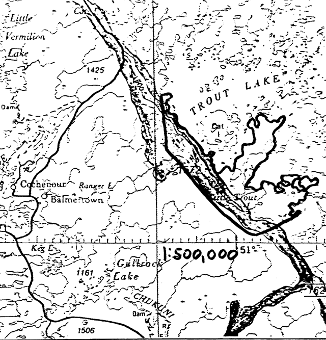
Regional setting map
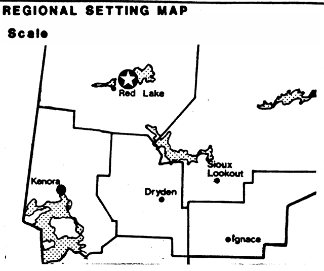
Enlarge figure 1: Regional setting (PDF)
Targets
1. Life science representation
- site type/landscape unit: L.U. 18 - Lac Seul Moraine - Trout Lake Portion
- species/communities: Central Boreal Forest Region and associated vegetation-complexes
2. Earth science representation
- geological theme: Timiskaming Interstadial
- feature: Lac Seul Moraine
Lake Agassiz - raised strandlines
3. Cultural resource representation
- theme: Unknown
- theme segment: Unknown
4. Recreation opportunities
- day use: N/A
- car camping: N/A
- wilderness/back country: N/A
Inventories
| Level/type | Earth science | Life science | Cultural | Recreational |
|---|---|---|---|---|
| Reconnaissance completion date | Feb. 1979 | N/A | ||
| Detailed completion date | ||||
| Required? | Yes | Yes |
Management guidelines
I. Land tenure
There is one Land Use Permit in the park issued to Booi’s Wilderness Lodge for the purposes of a waste disposal site.
Guideline
The L.U.P. for the waste disposal site will be cancelled and the site rehabilitated to its original condition.
II. Land acquisition/disposition
There are no patented lands within the park area at this time. The disposition of land within the park will not occur pending the completion of the park management plan.
III. Existing/proposed development
There is no existing within the park area and none will be permitted pending the completion of the park management plan.
IV. Recreation activities
A small amount of sport hunting and camping presently occur along the shoreline of the park.
Guideline
Sport hunting will not be permitted within the park area once it is brought into regulation under the Provincial Parks Act. Enforcement will be accomplished through communication within park literature and signage along the shoreline of the park.
Camping along the shoreline of Trout Lake within the park area will be permitted to continue. The Trout Lake Provincial Nature Reserve is considered to be a non-operating park and as such, the Crown land camping permit fee will apply.
V. Commercial activities
There are presently portions of two traplines (R1-58 and RL-72) and one trapline cabin located within the park area.
The park lies within the Great Lakes Management Unit and the Red Lake Crown Management Unit.
No other commercial activities presently exist.
Guideline
Trapping will be permitted to continue as a non-conforming use and will be phased-out over time. In the event of a request for a transfer of either of the above two licences, the area contained within the park will be excluded from the reissued licence. The trapline cabin will be removed or dismantled when no longer required and the site rehabilitated to its natural condition.
The portion of the park within the Great Lakes Management Unit is under a Forest Management Agreement. This area has been excluded from the F.M.A. The portion of the park within the Red Lake Crown Managment Unit has been removed from timber harvesting operations.
The above situation will be reflected in all management and operating plans that cover the park area. Once the area is regulated under the Provincial Parks Act, an Order-in-Council will be prepared to formally withdraw the park area from the above licence areas.
No other commercial activities will be permitted pending the completion of the park management plan.
VI. Natural resources
A number of earth science values have been documented for the park as detailed in the attached check sheet. Interim management efforts will be directed towards the protection of these earth science values.
Due to the proximity of the areas, all fires within the attack and fire suppression techniques used will have as park to licenced forest harvesting park will be subject to initial efforts. Fire suppression minimal effect as possible on the park environment. Such means of suppression as bulldozing, helipad locations, fire camps, and water bombing with chemical additives will not be permitted except in critical situations.
VII. Research
More complete earth and life science inventories will be necessary prior to the preparation of the park management plan.
Research activities that will enhance our scientific and resource knowledge of the park will be encouraged.
VIII. Native interests
The park lies within the Treaty #3 area. Traditional native uses, including hunting and fishing for personal use, will be permitted to continue within the park area.
IX. Cultural resources
There are no known cultural resources within the park area.
Sources/references
Gray, Stephen L. 1980. Life Science Systems Planning Report West Patricia Land Use Plan.
Harvey, E.T. 1980. Earth Science Systems Planning in the West Patricia Planning Area, Final Report.
Harvey, T., S.L. Gray, B. Thacker 1980. Landscape units of the West Patricia Land Use Planning Area.
Ontario Ministry of Natural Resources, Backgrounder - District Land Use Guidelines, June 1983.
Recommended nature reserve candidates
Uses recommended to continue prior to and after regulation
| Name | MNR Region | Size (ha) | Mineral exploration/development uses | Hunting uses | Trapping uses | Commercial tourism uses | Commercial fishing uses | Bait fishing uses | Other uses |
|---|---|---|---|---|---|---|---|---|---|
| 1. Trout Lake* | NW | 7,850 | Phase out | ||||||
| 2. Windigo Point* | NW | 380 | Phase out | ||||||
| 3. Lola Lake | NW | 6,350 | Yes | Yes | Yes | Yes | |||
| 4. Butler Lake | NW | 3,290 | Yes | Yes | Yes | ||||
| 5. Bonheur | NW | 720 | |||||||
| 6. Minitaki Kames* | NW | 4,340 | Phase out | ||||||
| 7. Sable Island | NW | 1,800 | Yes | Yes | |||||
| 8. Gameland | NW | 2,200 | Yes | Yes | Yes | Yes | |||
| 9. Nelles Township | NW | 800 | Yes | Yes | Yes | ||||
| 10. Blue Township | NW | 1,600 | Yes | Yes | Yes | Yes | |||
| 11. West Bay | NC | 1,140 | Yes | ||||||
| 12. Windigo Bay | NC | 8,300 | Yes | ||||||
| 13. Sedgeman Lake | NC | 5,800 | Yes | Wild Rice | |||||
| 14. Edward Island | NC | 530 | Yes | ||||||
| 15. Kiashk/Gull River | NC | 230 | |||||||
| 16. White Fish Lake (W) | NC | 1,150 | |||||||
| 17. White Fish Lake (E) | NC | 190 | Yes | ||||||
| 18. Thompson Island | NC | 170 | Yes | ||||||
| 19. Craig’s Pit | NC | 480 | Yes | Yes | Yes | Yes | |||
| 20. Matawin River | NC | 2,650 | Yes | Yes | |||||
| 21. Pantagruel Creek | NC | 2,200 | Yes | ||||||
| 22. Kab River | NC | 1,970 | Yes | Yes | |||||
| 23. Fraleigh Lake | NC | 870 | Yes | Yes | |||||
| 24. Devon Road Mesa | NC | 90 | |||||||
| 25. Pigeon River Clay Plain | NC | 2,870 | Yes | Yes | |||||
| 26. Prairie River Mouth | NC | 290 | Yes | Yes | Yes | Yes | |||
| 27. Gravel River | NC | 790 | Yes | Yes | Yes | Yes | |||
| 28. Arrowhead Penninsula | NC | 490 | |||||||
| 29. Pie Island Mesa | NC | 50 | |||||||
| 30. Red Sucker Point | NC | 380 | Yes | Yes | Yes | Yes | |||
| 31. Kama Hill | NC | 1 | |||||||
| 32. Puff Island | NC | 2 |
Source: Backgrounder, District Land Use Guidelines, OMNR, 1983
Earth science features map - Trout Lake Provincial Nature Reserve
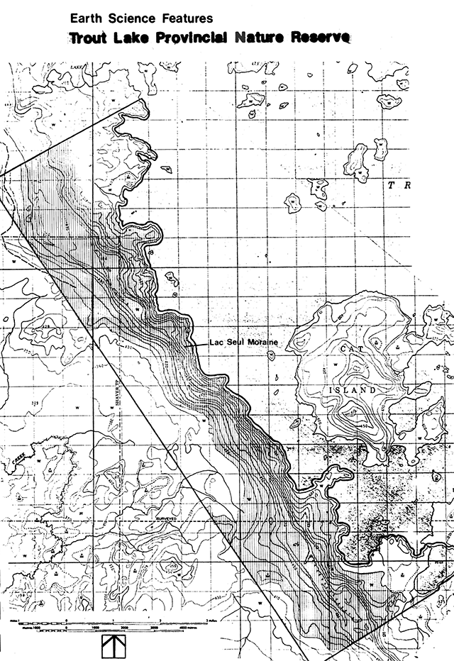
Enlarge Earth science features map - Trout Lake Provincial Nature Reserve
Development map - Trout Lake Provincial Nature Reserve
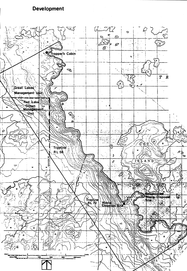
Enlarge Development map - Trout Lake Provincial Nature Reserve (PDF)
- name: Trout Lake Crown Reserve
- map name: Little Trout Lake
- map number: 53N/3
- UTM reference: 80 70
- county: District of Kenora
l at: 51°15'- long: 94°30'
- alt. min.: 479 m
alt. max.: 392 m - township: Patricia Portion
- lot: [no information provided]
- concession: [no information provided]
- area: 21420 hectares
- ownership: Crown Reserve
- administration: Northwestern Region
- MNR region and district: Red Lake
- conservation authority: [no information provided]
- aerial photographs - basemaps
federal - 1:63,000 scaleYear Roll Flight line Numbers 152 A15582 11-15 A13902 2-7 A14531 117-114 A13907 68-69
Enlarge Little Trout Lake map (PDF)
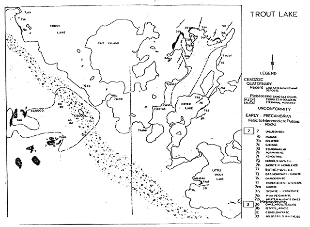
Earth science features
- minor metasediments (quartz-biotite-hornblende-feldspar paragneiss) on the peninsula between Otter Lake and Trout Lake; elsewhere silicic plutonic rocks, all from the Uchi Volcanic Subprovince
- Timiscaming stadial - Lac Seul moraine, a variety of features and shoreline sequences from Lake Agassiz history
Sensitivity
- no problems anticipated
Significance
- poor representation of bedrock features
- excellent [missing text]
- excellent representation of middle Lake Agassiz history
Major references
Breaks, F. W. 1972. Geological Survey of Proposed Provincial Park on Trout Lake, near Red Lake, Ontario. Project 72-X, unpublished report by Ont. Div. Mines, Ministry of Natural Resources, 3p. 1 map.
Breaks, F. W. , Bond, W.D. and Stone, Denver, 1978. Preliminary Geological Synthesis of the English River Subprovince, Northwestern Ontario and Its Bearing Upon Mineral Exploration; Ont. Geological Survey Misc. Paper MP72, 55p. Accompanied by map P 1971, Scale 1:263,440.
Kor, P. 1979. Earth Science Systems Planning - Phase II, Northwestern Region; Provincial Parks Branch internal report.
Prest, V.K. 1963. "Red Lake-Lansdowne House Area Northwestern Ontario" - Surficial Geology GSC Paper 63-6.
Prest, V.K. 1970. Quaternary Geology, Chapter 12 in Geology and Economic Miner als of Canada (R.J.W. Douglas, ed). p. 675-764.
Riley, R. A. 1973. The Lac Seul Moraine, unpublished report by Resident Geologist, Red Lake; Ontario Div. of Mines, 2 p. 1 map.
Riley, R. A., King, H.L., Kustra, C.R. 1971. Mineral Exploration Targets in Northwestern Ontario; Ont. Dept. Mines and Northern Affairs. Misc. Paper 47.
Saarnisto, M. 1974. The deglaciation history of the Lake Superior Region and Its Climatic Implications, Quaternary Research 4, p. 316-339.
Stockwell, C.H. 1964. Report on structural provinces, orogenies and time-classification of rocks of the Canadian Precambrian Shield. Geological Survey of Canada, Paper 64-17.
Zoltai, S.C. 1961. Glacial History of a Part of Northwestern Ontario, Proc. Geol. Assoc. Canada, Vol. 13, p. 61-83.
Zoltai, S.C. 1967. Eastern Outlets of Lake Agassiz in Life, Land and Water, (Mayer-Oakes, W.J., ed); Univ. of Manitoba Press, Winnipeg, p. 107-121.
Date compiled
February 23, 1979
Compiler
T. Harvey, Box 89, Cochenour
Physical features
Bedrock geology
The Crown Reserve is underlain by rocks of the Canadian Shield, formed at least 2.5 billion years ago during the Archean era (Stockwell, 1964). The Red Lake area forms part of a structural subprovince of the Canadian Shield called the Uchi Volcanic Belt (Riley et al., 1971), which is composed of volcanic sequences intruded by multiphase granitic plutons. The volcanics (basalt to rhyolite were laid down in one or more complex cycles exhibiting a trend in deposition from an early mafic phase to a late felsic phase. Metasediments (arkose, greywacke, chert) are usually at the top of the sequence overlying and intertongued with felsic metavolcanics. These belts of metavolcanics are surrounded by numerous discrete, and largely unmetamorphosed batholiths (Breaks et al., 1978).
A brief report by Breaks (1972) presents a detailed of the bedrock geology from which the following is summarized. The bedrock map which they prepared is addended to the checksheet. Bedrock outcrop is sparse and largely confined to the shore of Trout Lake. Silicic plutonic rocks underlie most of the reserve but minor outcrops of metasediments of quartz-biotite-hornblende-feldspar paragneiss and amphibolite occur at the end of the peninsula between Cat Island and Otter Lake, so intensely deformed that primary textures and structures have been destroyed. Massive to foliated granodiorite are associated with the paragneiss and are found injected in a lit-par-lit fashion. A late massive pink medium to coarse grained quartz monzonite phase occurs on the mainland opposite Cat Island and just east of Otter Lake. Amphibolite (originally thin lenses of quartz-poor greywacke or argillite) bands occurs as rafted xenoliths incorporated into a monzonite intrusive phase on the west shore. A circular aeromagnetic anomaly was also investigated but its origin in unknown because of the Lac Seul moraine is at its thickest point in the area. One postulate is that the anomaly may be result of a magnetite-bearing porphyritic granitic stock.
Surficial geology
Fifteen sites in the vicinity of the Crown Reserve were examined from July 5 and 6, 1978 by helicopter. Field site descriptions are available with the original checksheet. These compliment an additional twenty stops noted by Ontario Centre for Remote Sensing in their 1977 mapping season. Publication by OCRS of a map of the surficial geology of 52N is imminent. Aerial photo analysis has been used to prepare the attached map (scale 1 inch to 1 mile).
Trout Lake is dammed by a prominent terminal or end moraine deposited by one or more ice advances during gradual recession of the Wisconsin ice sheet between 10,000 and 11,000 years ago (Saarnisto, 1974; Timiscaming Interstadial). The ridge, called the Lac Seul moraine (locally the Trout Lake ridge) is sharp crested for the most part and variably modified by lacustrine action. Evidence for more than one advance can seen in a gravel pit to the north (TRl9: 52N/5, 608 780) in which ablation till overlies proglacial deposits. The moraine is largely composed of stratified sand and gravel deposited as outwash but may well be capped by a thin layer of ground moraine which has subsequently been heavily modified and or removed. The upper surface is boulder strewn and predominantly composed of well sorted lacustrine sands. The eastern side is a-steep sided face formed in contact with the ice as the glacier deposited sands and gravels towards the west. The western side in contrast is gently sloping and terraced by Lake Agassiz shorelines. Less prominent shorelines notch the eastern side formed by impounded water between the receding ice front and the moraine. A small esker can be traced across Otter Lake and near its junction with the moraine, the esker surface is hummocky with several small aligned kettles (OCRS site 13). Cat Island contains a lake modified remnant of the moraine (OCRS site 22).
The remainder of the crown reserve is overlain by the lacustrine deposits and wave modified glacial drift. On the poorly drained peninsula between Otter Lake and Trout Lake immature sandy silts were noted thinly covering paragneiss. An OCRS sample (15) indicates that parts of the bedrock drift complex were not so heavily modified east of Little Trout Lake. A winnowed ground moraine surface was observed. Greater thicknesses of silts and clay (both varved and unlaminated) can be found on the west side of the Lac Seul moraine. Generally the grain size becomes finer further west of the moraine where deeper water conditions prevailed and fines upwards stratigraphically, indicative of the increasing distance from the source of sediment as the glacial front receded eastwards.
The Lac Seul moraine exhibits a variety of beach features (cobble bars and terraces) which were formed by the nearly 1000 yr. life of Lake Agassiz. Several points along the crest of the moraine escaped inundation by Lake Agassiz (higher than 477 metres at 52N/3 799524-TRl3 and 52N/3 667703-TRJ) (Prest, 1963) although ice blocks probably were part of exposed surface. When the ice block melted flat bottomed depressions (kettles) were formed, filled with thin silt deposits. A spectacular two metre high boulder beach rampart forms a prominent crest along the western side of the moraine at 470 m. Boulders averaging a metre in size at TR3 attest to the strength and duration of Lake Agassiz wave action. Several other strandlines at 420 m, 440 m and a prominent level at 450 m record brief halts in the gradual retreat of glacial waters. A cuspate foreland was developed between the moraine and a bedrock knob further west at approximately 410-420 m (52N/3 735 545). Prominent terraces are also found on Cat Island at 450 m and 440 m above which the ground appears to be unmodified.
Zoltai (1967) attempted a correlation of shorelines and eastern outlets using elevations from the Lac Seul moraine. Just north of the junction, between the Hartman and Lac Seul moraine (525/14 869 445) a shoreline was recorded at 1515 ft. Prest (1963) indicated that the limit of wave action further north along the moraine was 1550 ft. or 225 ft above the level of Trout Lake (at 52N/3 667 703). However both of these elevations appear to be in error because the 1:250,000 maps from which they were estimated are inaccurate by nearly 100 ft. Recently published 1:50,000 topographic maps allow the correction of these sites to 480 m (1575 ft) for Zoltai’s site and 477 m (1565 ft) for Prest’s site. Zoltai (1967) showed that the calculated elevations fell upon the Campbell waterplane but when corrected they fall below the water plane. Rough calculations based upon Elson’s (1967) water planes suggests that the Lac Seul moraine may have been formed at the lower Campbell stage slightly later than previously dated. Other shorelines are similarly tentatively correlated to McCauleyville (470 metres) through Gladstone (410 metres).
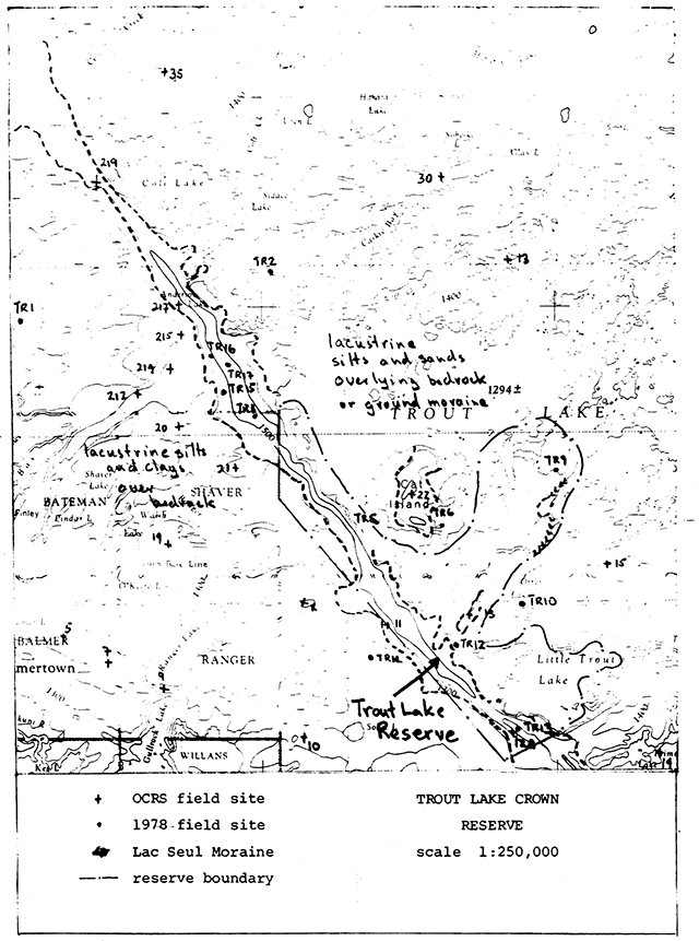
Enlarge Trout Lake Crown Reserve map
Sensitivity
Fine sands which exist on some parts if exposed to the wind. However open ground years ago have not suffered deflation. The to withstand usual park use. The peninsula of the moraine can be mobilized as a result of a fire fifteen area then seems to have the resiliency between Otter Lakes and Trout Lake is poorly drained and may present difficulties if development is attempted.
Significance and recommendations
Bedrock outcrop is so minor that Uchi Belt metasediments are poorly represented. Other bedrock units are adequately represented further west in Woodland Caribou Park where their abundant exposure provides the opportunity for study and significance.
The Lac Seul moraine, an essential of the Timiscaming Interstadial, is not well represented in the Provincial Parks System in Northwestern Ontario (Kor, 1979). Several important aspects are well displayed-ice contact face; a small esker system entering the moraine; sloping western side from deposition of outwash in Lake Agassiz and several unmodified kettles along the crest. A wide variety of beach forms are present on the Lac Seul moraine although beach features are generally well represented in Provincial Parks. Boulder ramparts are an uncommon feature however. The shorelines were formed by middle stages of Lake Agassiz from lower Campbell to Gladstone (?). This part of the Lac Seul moraine is certainly one of the best locations for representing shoreline sequences because the ridge has a high relief and underwent a higher rate of uplift than at more southerly locations. The sequence therefore provides an excellent opportunity for the study and interpretation of glacial lake shorelines.
The Trout Lake Crown Reserve should be designated a Provincial Park because of the contribution that it can make to the Earth Science component of the Provincial Parks Protection Objective. Classification as a Natural Environment Park would also allow the development of recreation facilities. The location of the reserve is excellent since adequate quantities of aggregate would still be available to service the long term needs of Red Lake from the more accessible portions of the moraine along the Nungesser Road, Representation of the Lac Seul would be further enhanced by expanding the boundary westwards (no more than 4 km) to provide a more complete representation of fine grained sediments and fully protect the cuspate foreland on the flank. It is also suggested that if camping facilities are considered, the west side of Little Trout Lake and otter Lake would be most appropriate, judging by this preliminary analysis. The area could be serviced along the shore of Little Trout Lake from logging roads to the south thereby preventing disturbance of the Lac Seul moraine.
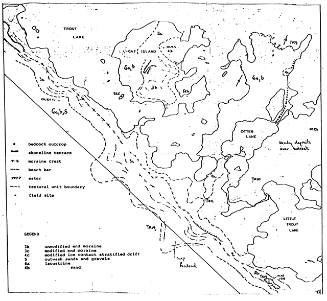
Enlarge Trout Lake Crown Reserve bedrock map