Turtle River-White Otter Lake Provincial Park Management Plan
This document provides policy direction for the protection, development and management of Turtle River-White Otter Lake Provincial Park and its resources.
Park Management Plan
© 2012, Queen’s Printer for Ontario
Copies of this publication are available from the Ministry of Natural Resources at the following locations:
Ignace Area Office
Hwy 599
P.O. Box 448
Ignace, ON P0T 1T0
Tel: 807-934-2233
Fax: 807-934-2304
Atikokan Area Office
108 Saturn Ave.
Atikokan, ON P0T 1C0
Tel: 807-597-6971
Fax: 807-597-6185
Dryden District Office
479 Government Road
P.O. Box 730
Dryden, ON P8N 2Z4
Tel: 807-223-3341
Fax: 807-223-2824
Fort Frances District Office
922 Scott Street
Fort Frances, ON P9A 1J4
Tel: 807-274-5337
Fax: 807-274-4438
Ontario Parks
Northwest Zone Office
Suite 221d 435 James St. S.
Thunder Bay, ON P7E 6S8
Tel: 807-475-1231
Fax: 807-475-1499
Planning questions can be addressed to:
Superintendent, Turtle River – White Otter Lake
Provincial Park
Dryden District Office
479 Government Road
P.O. Box 730
Dryden, ON P8N 2Z4
Tel: 807-223-7535
Ontario Parks
Northwest Zone Office
Suite 221d 435 James St. S.
Thunder Bay, ON P7E 6S8
Tel: 807-475-1231
Cette publication hautement spécialisée Turtle River-White Otter Lake Park Management Plan n'est disponible qu'en Anglais en vertu du Règlement 411/97 qui en exempte l'application de la Loi sur les services en français. Pour obtenir de l'aide en français, veuillez communiquer avec Robin Reilly au ministère des Richesses naturelles au 807-597-5018 ,ou robin.reilly@ontario.ca.
52676
0.2k P.R. 01 12 12
ISBN – 978-1-4435-4654-6
Approval statement
I am pleased to approve the Turtle River-White Otter Lake Park Management Plan as the official policy for the management and development of this park. The plan reflects the intent of the Ministry of Natural Resources, Ontario Parks to protect the natural and cultural features of Turtle River-White Otter Lake Park and to maintain and develop opportunities for high quality outdoor recreation experiences and heritage appreciation for the residents of Ontario and visitors to the province.
This document outlines an implementation strategy for the plan’s elements and summarizes the Aboriginal and public involvement that occurred as part of the planning process. Consultation occurred at the terms of reference and preliminary park management plan stages. Consultation activities included direct notices, newspaper advertisements, the Ontario Parks' website and postings on the Environmental Bill of Rights, 1993 registry.
The plan for Turtle River-White Otter Lake Park will be used to guide the management of the park over the next twenty years. During that time, the management plan may be reviewed to address changing issues or conditions, and may be amended as the need arises. This plan will be examined in accordance with the provisions of the Provincial Parks and Conservation Reserves Act, 2006 in 10 years.
I wish to extend my sincere thanks to all those who participated in the planning process.
Yours truly,
Signed by:
Michael Gravelle
Minister of Natural Resources
Date: July 19, 2012
Context
Provincial Parks and Conservation Reserves Act
The Provincial Parks and Conservation Reserves Act, 2006 (PPCRA) is the legislation that guides the planning and management of the protected areas system. The PPCRA has two specific principles that guide all aspects of planning and management of Ontario’s system of provincial parks and conservation reserves:
- Maintenance of ecological integrity shall be the first priority and the restoration of ecological integrity shall be considered
- Opportunities for consultation shall be provided. 2006, c. 12, s. 3
Consideration of the Ministry of Natural Resources' Statement of Environmental Values under the Environmental Bill of Rights
The Ministry of Natural Resources' Statement of Environmental Values (SEV) under the Environmental Bill of Rights, 1993 (EBR) describes how the purposes of the EBR are to be considered whenever decisions are made in the ministry that might significantly affect the environment. This includes decisions made as a result of preparing management direction for a protected area.
The ministry’s SEV has been considered throughout the planning process. The management direction for Turtle River–White Otter Provincial Park will further the objectives of managing Ontario’s resources on an environmentally sustainable basis.
Planning context
This park management plan has been prepared consistent with direction contained in Our Sustainable Future: A Renewed call to Action, Ministry of Natural Resources Strategic Directions (OMNR 2011), in Protecting What Sustains Us: Ontario’s Biodiversity Strategy (OMNR 2011a) and in Ontario Provincial Parks: Planning and Management Policies (OMNR 1992). Additionally, Turtle River–White Otter Lake Provincial Park will be managed to protect any species at risk and their habitats in a manner consistent with the Endangered Species Act, 2007 (ESA, 2007) and regulations.
All activities undertaken in Turtle River-White Otter Lake Provincial Park must comply with A Class Environmental Assessment for Provincial Parks and Conservation Reserves (Class EA-PPCR; OMNR 2005b), where applicable.
Aboriginal peoples
Wabigoon Lake, Lac La Croix, Seine River, Lac des Milles Lacs, Nigigoonsiminikaaning and Couchiching are nearby First Nations and are all within the boundary described by the Treaty #3 (Figure 1). Turtle River–White Otter Lake Provincial Park is part of the traditional use area of these Aboriginal communities. There are no land claims regarding Turtle River-White Otter Lake Provincial Park at this time.
Turtle River–White Otter Lake Provincial Park overlaps traditional lands and waters of these six First Nations who use the area for hunting, trapping, fishing, gathering and travel.
Turtle River–White Otter Lake Provincial Park overlaps two Métis Nation of Ontario (MNO) asserted harvesting territories; Lake of the Woods/Lac Seul and Rainy Lake/Rainy River. The closest modern day community councils that may have an interest include Northwest (Dryden), Kenora, Sunset Country (Fort Frances), and Atikokan Métis Councils. The Aboriginal Peoples of Wabigoon are also located in the area.
In recognition of the Aboriginal archaeological features located within the park, Ontario Parks will have special regard for local Aboriginal communities' particular interests. Respect and protection of archaeological and cultural features are integral to this park management plan. Involvement opportunities will be provided to Aboriginal communities regarding any issues of concern during the implementation of this plan.
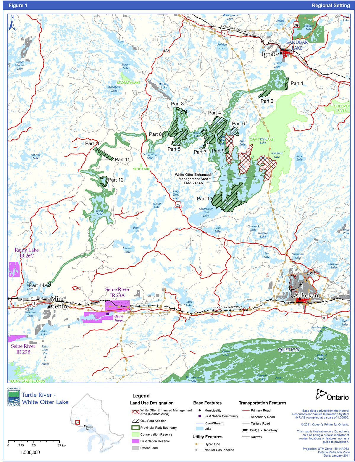
Figure 1: Regional setting

Enlarge Figure 1: Regional setting
1.0 Introduction
Turtle River Provincial Park was formally established as a waterway class park in May 1989. The park originally extended for about 160 kilometres along the Balmoral and Turtle Rivers and associated lakes, and totalled 40,052 hectares. In 2003, the park was renamed Turtle River–White Otter Lake Provincial Park and the boundary was amended to include additions recommended through Keep It Wild and Ontario’s Living Legacy (Figure 1). It now totals 49,294 hectares and is a non-operating park. For a more detailed summary of park planning to date and additional information on Lands for Life/Ontario’s Living Legacy refer to section 13.5.
Turtle River–White Otter Lake Provincial Park makes a major contribution to the provincial parks system. The Turtle River waterway has long been recognized as a significant canoe route and natural area with unique biophysical, recreational, and cultural attributes.
The Turtle River water route proceeds from McNamara Lake over a height of land, to the headwaters of the Balmoral River, and continues downstream to join the Turtle River-proper near White Otter Lake. There are numerous lakes, 22 sets of rapids, and about 30 portages along the route. White Otter and Eltrut are the park’s largest lakes, followed by McNamara, Dibble, Smirch, and Jones. The park is used extensively in summer for activities such as boating, canoeing, and angling, while use of motorized snow vehicles and ice fishing are popular winter activities.
The park’s waters vary widely, from the clear cold lake trout habitat of White Otter Lake to the warm brownish waters of Jones and Eltrut lakes. The southern reaches of the waterway have large marshes and areas of wild rice, which provide abundant habitat for moose and waterfowl. Some of the park’s vegetative and glacial features are considered to be of regional and provincial significance.
The park is situated in a bedrock-controlled landscape typical of the Precambrian Shield, while the park’s vegetation is representative of the transitional zone between the Great Lakes-St. Lawrence and Boreal forest regions. Boreal forest species such as white spruce, black spruce, balsam fir, jack pine, trembling aspen, and white birch are found interspersed with red and white pine and other species more typical of the Great Lakes-St. Lawrence forest.
The waterway has been used for centuries as a travel and trade route within the Rainy River basin, and the abundance of pictographs (rock art) along the waterway attests to its Aboriginal importance. The most distinctive historical resource within the park is White Otter Castle, one of the best-known visitor attractions in the area. This enigmatic three-storey log structure was completed in the 1910s by Jimmy McQuat. Though not accessible by road, it is visited year round, via watercraft, aircraft and motorized snow vehicles, by an estimated 5,000 to 7,000 persons annually.
Another protected area established through Ontario’s Living Legacy is Campus Lake Conservation Reserve (C2299), which abuts Turtle River–White Otter Lake Provincial Park around the north ends of Ann and Sucker Bays of White Otter Lake. This 19,452 hectare conservation reserve contains representative landforms and vegetation types, including weakly broken beach, aeolian deposits and ground moraine. It also encompasses some spectacular scenic and recreational areas that complement Turtle River–White Otter Lake Provincial Park. The conservation reserve complements the park by protecting a diverse range of vegetation and landform features, as well as the recreational and tourism potential of several scenic lakes linked by canoe routes to White Otter Lake.
White Otter Enhanced Management Area (EMA) (E2414) is another land use designation resulting from Ontario’s Living Legacy. This is a remote and relatively undeveloped area with excellent potential for further eco-tourism and backcountry recreation. The primary intent of the EMA is to carry out forest management activities in a manner that will facilitate future recreation and tourism potential and to avoid undesirable impacts on protected area values through careful planning of new road locations.
Other provincial parks in the vicinity include Sandbar Lake, East English River, Bonheur River Kame, and Quetico. Tourist attractions in the area that link to the historical themes associated with Turtle River–White Otter Lake include:
- the mining museum in Atikokan
- Manitou Mounds in Barwick, and
- Fort William Historical Park in Thunder Bay
Turtle River–White Otter Lake Provincial Park is located between the Town of Ignace on Highway 17, the hamlet of Mine Center and the Town of Atikokan on Highway 11. Other communities in the area include Upsala, Dryden, Fort Frances, Kenora and Thunder Bay.
The approved management plan will guide the management, operation and development of Turtle River–White Otter Lake over the next 20 years. The plan may be re-written or amended as the need arises; Section 12 describes the process for examination and amendment of the plan.
2.0 Classification
Through park classification, Ontario’s provincial parks are organized into broad categories, each of which has particular purposes and characteristics.
Turtle River–White Otter Lake Provincial Park is classified as a waterway park. The class target for waterway parks is to establish at least one representative waterway in each of Ontario’s 71 ecodistricts. Turtle River–White Otter Lake Provincial Park helps to fulfil the representation target for waterway class parks in Ecodistrict 4S-5.
Waterway class parks protect recreational water routes and representative and significant terrestrial and aquatic ecosystems and associated natural and cultural features. They also provide high quality recreational and educational experiences.
The waterway classification recognizes the park’s ability to protect a scenic waterway and representative samples of Precambrian Shield and southern boreal forest, as well as the significant rock art sites along the waterway. It acknowledges the recreational and educational opportunities offered, the park’s scenic setting, and the popularity of White Otter Lake and Castle as popular visitor destinations.
3.0 Goal
The goal of Turtle River–White Otter Lake Provincial Park is:
To protect significant natural and cultural features of Turtle River– White Otter Lake Provincial Park and to provide a wide variety of compatible heritage appreciation, ecologically sustainable outdoor recreation opportunities and scientific research activities, in order to achieve the objectives of the provincial parks system.
Turtle River–White Otter Lake Provincial Park is governed by Ontario’s PPCRA, Ontario Provincial Parks: Planning and Management Policies (OMNR 1992a) and Ontario’s Living Legacy - Land Use Strategy (OLL-LUS; OMNR 1999).
4.0 Objectives
There are four objectives for Ontario’s provincial parks: protection, recreation, heritage appreciation and scientific research. Each park in the system may contribute in some way to each of these objectives, depending on its resource base. Turtle River–White Otter Lake Provincial Park contributes to the achievement of all four objectives.
4.1 Protection
To permanently protect the representative ecosystems, the biodiversity and the provincially significant elements of the natural and cultural landscape of Turtle River–White Otter Lake Provincial Park and to manage these to ensure that ecological integrity is maintained.
Ontario’s protected areas play an important role in representing and conserving the diversity of Ontario’s natural features and ecosystems, across the broader landscape. Protected areas include representative examples of life and earth science features, and cultural heritage features within ecologically or geologically defined regions. Ontario’s ecological classification system provides the basis for the life science feature assessment, and the geological themes provide the basis for earth science assessment.
The park contains natural and cultural resources that are provincially and regionally significant. These include:
- A number of ice contact deltas including McNamara Lake (regional), White Otter Castle (regional), and Lost Bay (provincial)
- An undisturbed section of the Eagle-Finlayson moraine (regional)
- A remnant of glacial Lake Agassiz shoreline (regional)
- Peatlands and transitional wetlands with plant species at the northern limits of their ranges (regional, possibly provincial)
- Old growth red pine and white pine forest (local)
- The prime lake trout fishery of White Otter Lake (local)
- White Otter Castle (regional)
- 37 known pictograph sites and 39 known prehistoric habitation sites as well as the remains of logging and prisoner of war camps (regional)
The protection objective will be accomplished through appropriate park zoning, resource management policies, research, and monitoring.
4.1.1 Life science
Turtle River–White Otter Lake Provincial Park is situated in Ecodistricts 4S-5 and 3W-2. Due to the linear extent of the park, a vegetational gradient ranging from southern pine species of the Great Lakes-St. Lawrence Forest to the spruce/fir/birch species of the boreal forest is protected.
The Quetico section of the Great Lakes- St. Lawrence Forest contains both red and white pine as individuals or in small stands. Several boreal forest species are also prevalent in this area with jack pine, trembling aspen, white birch, balsam fir, white spruce, and black spruce commonly observed. In wet valley sites hardwood species such as black ash, elm, and red maple are common. Along lake shores eastern white cedar is often prevalent. Black spruce and eastern tamarack are most often encountered in bogs and poor fens.
In the Upper English River section of the boreal forest, the main forest cover is black spruce and jack pine. Jack pine is prevalent on dry sand flats and rocky uplands with black spruce the more common species in the moist, peat-filled sections of forest. In moderately dry habitats, mixed stands are common with jack pine and black spruce sharing the canopy with white spruce, balsam fir, trembling aspen, and white birch. Red and white pine also occur but reach their northern limits here and are usually only found as individuals, or in isolated clumps. Other species reaching the northern limits of their distribution in this section are the large-toothed aspen, yellow birch, and eastern white cedar. On drier sites several species not characteristic of the boreal forest, such as bur oak and white elm, can be observed (Hills 1959).
Adding to the park’s complexity is the presence of a southern deciduous/prairie transitional element such as birch, oak, green ash, and silver maple on alluvial sites at the southern end of the park.
Soils range from deep mineral to deep organic and shallow dry-very fresh to shallow moist soils.
The faunal species found in the park are typical of the boreal forest, although a few species representative of the Great Lakes-St. Lawrence forest do occur, given the park’s location in a transitional forest region. Common mammals found within the park include moose, white-tailed deer, black bear, wolf, river otter, muskrat, beaver, mink, marten, fisher, fox, lynx, eastern chipmunk and red squirrel. Common bird species observed were least flycatcher, red-eyed vireo, winter wren, white-throated sparrow, yellow-rumped warbler, and Swainson’s thrush.
Provincially rare
Turtle River–White Otter Lake Provincial Park has a number of life science features that are of interpretive and educational significance. Life science values are protected within nature reserve and natural environment zones.
4.1.2 Earth science
Turtle River–White Otter Lake Provincial Park provides an ideal cross-section of granitic and gneissic rocks of the central portion of the Wabigoon Subprovince, including the White Otter batholith, a major Late Archean granitic intrusion. Although the influence of bedrock is readily seen in the drainage pattern of the park (e.g., rivers and lakes) it is the surficial material, or in some places lack of it, which often give an area its particular "look". The surficial geology of the park includes glaciofluvial outwash plain, kame and esker complexes. The presence of the rarely seen red clays interbedded with grey clays are also of significance as they represent the expansion and contraction of glacial Lake Agassiz in conjunction with the constantly changing ice front. A number of these earth science features are regionally and/or provincially significant and are of interpretive and educational significance.
Earth science values are protected within nature reserve and natural environment zones.
4.1.3 Cultural features
Turtle River–White Otter Lake Provincial Park has documented 39 archaeological sites, 37 pictograph sites (Rusak 1992) and numerous logging remnants dating back to the early 20th century have been documented.
As the glaciers retreated, Aboriginal people moved into the area in small nomadic groups, occupying different seasonal habitation sites to gather, hunt and fish. The discovery of pictographs, lithic flakes and pottery shards from the Laurel and Blackduck cultures document this use. Tobacco offerings, frequently observed at some of the pictograph sites, suggest that these areas remain significant to the contemporary First Nations people.
The Turtle River waterway was likely used for collecting and transporting furs after the Hudson Bay Company’s expansion inland. Logging began in the area around the turn of the century. Relics of this activity are found at several places in the park including the remains of three logging camps on White Otter Lake and an old amphibious "alligator" boat on the south shore of Eltrut Lake. The logging camp closest to the castle on White Otter Lake was used as a prisoner-of-war camp for German sailors from 1943 to 1946.
The most popular attraction in the park is the castle on White Otter Lake. Jimmy McQuat, a hermit of Scottish origins, settled on White Otter Lake in 1903 and built a unique 3-storey structure without the help of anyone. He completed the castle in 1914 at the age of 59. The castle is constructed of massive red pine logs, some of which are 30 to 40 metres in length and 50 centimetres in diameter, weighing up to one ton each. While living on White Otter Lake, McQuat worked as a trapper and commercial fisher until he drowned, in front of the castle, in 1918 while netting fish. McQuat’s grave can still be seen today beside the recently restored White Otter Castle.
The park has a number of cultural features that are of interpretive and educational significance. Cultural features are protected within historic and natural environment zones.
Respect for, and protection of, archaeological and cultural features that are integral to the management of this park plan. The Lac des Milles Lac First Nation, Wabigoon Lake First Nation, Lac La Croix First Nation, Seine River First Nation, Rainy Lake First Nation, Nigigoonsiminikaaning First Nation and Couchiching First Nation whose traditional land use areas all lie within the park, will be consulted on related issues of concern during implementation of the plan.
4.2 Recreation
To provide ecologically sustainable high quality river recreation travel and backcountry camping opportunities in an outstanding natural setting and to encourage associated economic benefits.
Recreational opportunities in the park range from moderate intensity day-use to low intensity backcountry experiences. Park management will accommodate and support quality recreational angling (summer and winter), hunting, canoeing, scenic and wildlife viewing, camping, motor boating, and use of motorized snow vehicles, including the provision of appropriate services and facilities.
The recreation objective will be achieved through appropriate park zoning; the identification of management policies to prevent any compromise of significant natural and/or cultural heritage values; market research and monitoring; and, mitigating impacts of recreational use.
As a non-operating park, statistical data on the patterns of recreational use of Turtle River–White Otter Lake has not been formally compiled to date. Use of the park has increased dramatically in recent years and the park is becoming a popular destination among local and regional residents, as well as with non-residents and organized youth groups. White Otter Castle is a popular destination for year-round visitation, and contributes to the local economies of Atikokan and Ignace.
Visitors to the operating provincial parks in the northwestern Ontario travel region originate in northwestern Ontario and in western Canada (approximately 40%), with substantial visitation from the American Midwest (about 40%), specifically Minnesota and Wisconsin. This is in contrast to the origins of park users on a province-wide basis where the majority of park visitors originate in the eastern and central parts of the province (approximately 65%) and only about 9% of visitors come from the United States.
Tourism industry trends such as an aging population, increasing concern for the environment, and interest in educational experiences, indicate market growth potential for soft adventure and ecotourism. Examples of products include experiences in natural environments/cultural heritage with packaging of wildlife/scenic viewing, water- and land-based recreation. Trend analyses of visitors from overseas (Europe and Asia) indicates strong interest in the outdoors, natural and cultural heritage, especially that of First Nations. Turtle River–White Otter Lake Provincial Park and the surrounding locale are well positioned as part of an international attraction, where there is opportunity for growth with independent tourists, and package tours (Van Wagoner 2000).
Tourism use will be encouraged to the greatest extent possible without adversely affecting the park environment or visitor experiences. Tourism opportunities exist for hunting, fishing, canoe trip outfitting and tours to White Otter Castle.
4.3 Heritage appreciation
To provide opportunities for residents of Ontario and visitors to increase their knowledge and appreciation and to participate in unstructured individual exploration of the natural and cultural heritage of Turtle River–White Otter Lake Provincial Park.
Opportunities will be provided for unstructured individual exploration and appreciation of the natural and cultural heritage of this important waterway. White Otter Castle will be a focal point of cultural heritage appreciation within the park; however the park also contains numerous pictograph sites and examples of industrial heritage related to the logging era. Significant earth science and life science features abound. This objective will be achieved through the provision of accurate up-to-date information to park visitors regarding the natural, cultural and recreational resources of the park through signage, park literature, trail guides and interpretive displays as required. Natural Heritage Education (NHE) is further discussed in Section 8.6.
4.4 Scientific research
To facilitate scientific research and to provide points of reference to support monitoring of ecological change on the broader landscape.
Ontario’s provincial parks play an important role in the provision of places to undertake research activities to: provide a better understanding of park environments, contribute to appropriate park management practices and actions, and provide baseline ecological information that can be used to support ecological monitoring on the broader landscape.
5.0 Boundary
The park was originally established in 1989 as Turtle River Provincial Park.
Several boundary changes have been made as a result of different land use planning initiatives designed to protect natural heritage. The 1992 preliminary park management plan proposed adding four sites to the park and deleting five. The 1994 Keep It Wild program recommended adding one site to the park. Ontario’s Living Legacy recommended adding six sites to the park (including the four proposed in the initial preliminary park management plan) and deleting one site. These three planning processes included opportunities for Aboriginal involvement and public involvement as part of the decision-making process. Boundary refinement, which included more consultation with stakeholders and the public, and notification of Aboriginal communities, has resulted in a variety of minor changes between the park additions as shown in the Land Use Strategy and those shown on Figure 1, Regional Setting, without changing the total net area of the additions.
The boundary changes (park additions) are:
- McNamara Lake Ice Contact Delta (238 ha) (Part 1 on regulation (reg.) plan)
- Site 2 (421 ha) (South of Elbow Lake) (Part 2 on reg. plan)
- Site 3 (481 ha) (Nora Lake) (Part 6 on reg. plan)
- White Otter Castle Ice Contact Delta (225 ha) (Part 9 on reg. plan)
- Site 6 (3,559 ha) (Rollingstone Lake) (Part 13 on reg. plan)
- Site 7 (2,068 ha) (Dimple Lake) (Part 4 on reg. plan)
- Site 8 (922 ha) (north of Heuston Lake) (Part 7 on reg. plan)
- Site 9 (2,045 ha) (Kenoshay Lake) (Part 5 on reg. plan)
- Site 10 (232 ha) (Paddy Lake) (Part 3 on reg. plan)
- Treed Bog Rocklands (146 ha) (Part 8 on reg. plan)
- Lake Agassiz Shoreline (468 ha) (Part 11 on reg. plan)
- Jones/Eltrut Riparian Wetlands (221 ha) (Part 12 on reg. plan)
- Turtle River Terminus (121 ha) (Part 14 on reg. plan)
- Ann Bay Ice Contact Delta (235 ha) has been removed from the park
Park management plan policies apply only to the area within the regulated boundary of the park. Within the park boundary, the protection of park values and features will be achieved through appropriate zoning, control of land use and activities, education, and monitoring of ecological impacts.
The boundary of Turtle River–White Otter Lake Provincial Park is shown on the Zoning, and Existing Development and Adjacent Land Use maps (Figures 2 and 3). All lands within 200 metres of the waterway shoreline and lands under water are included in the park, and in many areas, the boundary extends farther inland.
6.0 Park zoning
The types of zones that will guide the resource management, operations and development of Turtle River–White Otter Lake Provincial Park are nature reserve, historical, natural environment, access and development (Figure 3). No wilderness zones are included.
Zoning is a key part of a park management plan. Zones fulfill a variety of functions that may include:
- Recognizing the features and attributes of a park
- Delineating areas on the basis of their need for protection or their ability to protect provincially significant representative features
- Delineating areas on the basis of their ability to support various recreational activities; and
- Identifying uses that will protect significant features, yet allow opportunities for recreation and heritage appreciation
Management of the park’s resources is consistent with policies in Ontario Provincial Parks Planning and Management Policies (OMNR 1992a) and OLL-LUS.
Figure 2: Existing development and adjacent land use (Map 2A)
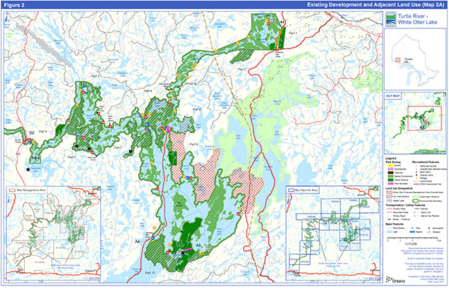
Enlarge Figure 2: Existing development and adjacent land use (Map 2A)
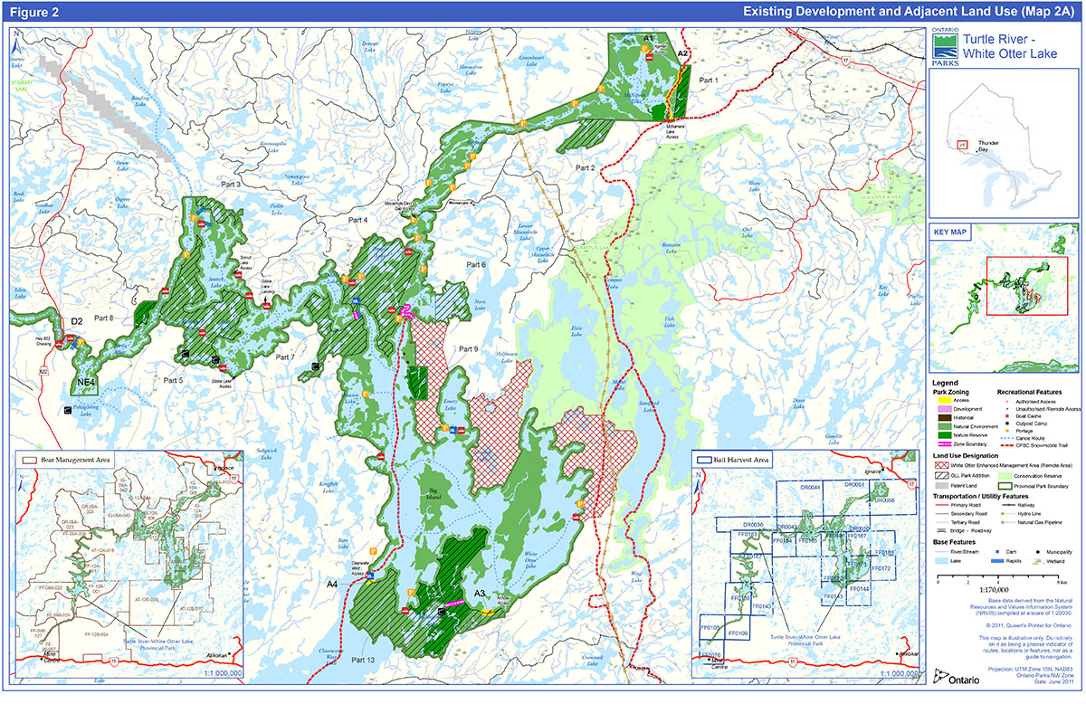
Figure 2: Existing development and adjacent land use (Map 2B)
Enlarge Figure 2: Existing development and adjacent land use (Map 2B)
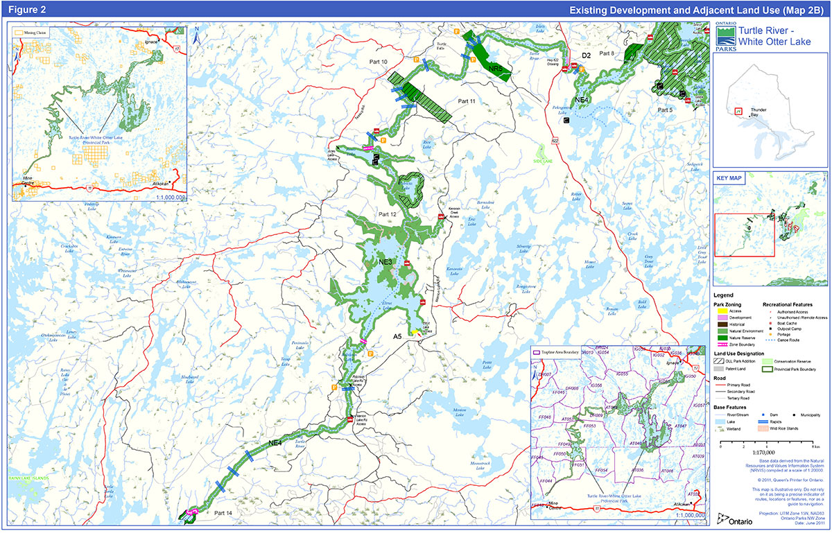
Figure 3: Zoning (Map 3A)
Enlarge Figure 3: Zoning (Map 3A)
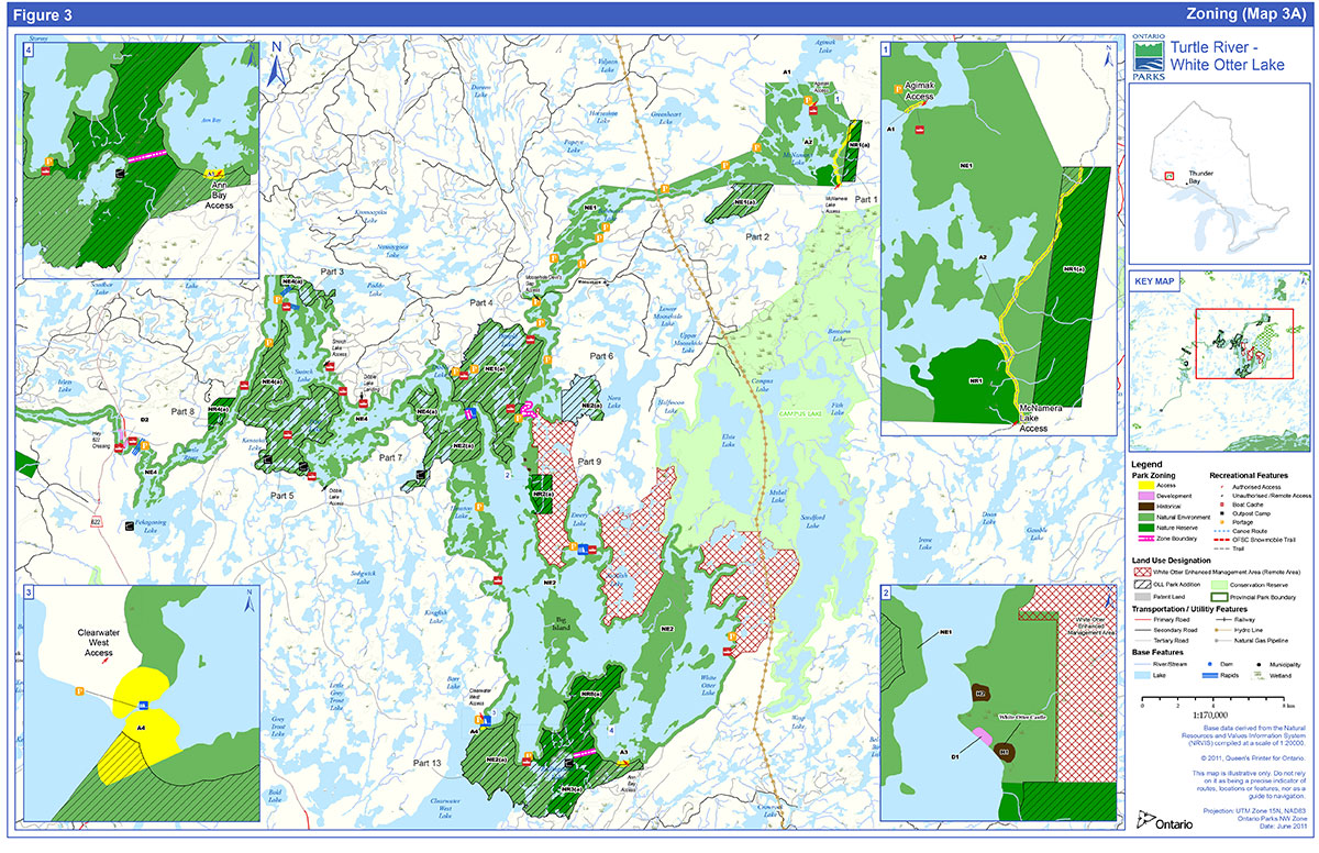
The park additions identified in OLL have been zoned based upon the preliminary park management plan (OMNR 1992b), the preliminary park management plan – revised (OMNR 2010), input during land use planning processes, and the known significance of values based on gap analysis. OLL additions are identified in the zone descriptions below with the addition of (a) to the zone type and number.
6.1 Nature reserve zones
Nature reserve zones protect the provincially significant earth and/or life science features within a park. Development is generally restricted to trails, necessary signs, interpretive facilities (where warranted) and temporary facilities for research and management. The waters within the nature reserve zones in Turtle River– White Otter Provincial Park are small ponds and streams that do not form part of the park’s canoe routes.
NR1 / NR1(a) - McNamara Lake ice contact deltas (360 hectares) zoning map 3A
This zone protects two good examples of ice contact deltas deposited in an ice margin lake between the Eagle-Finlayson Moraine to the south and the Hartmann Moraine to the north. These are regionally significant as the best ice contact delta example anywhere near the park. This zone is bisected by Zone A2 (McNamara Lake Winter Trail). Based on feedback from the local motorized snow vehicle club, a portion of the NR1 zone (158 ha) has been added to the NE1 zone in order to adjust the configuration of the A2 zone to more accurately indicate the actual route of their trail. Field work will be undertaken to ground truth the status of the ice contact delta / loess deposit. The NR1 boundary will be adjusted through an amendment to the park plan, if it is required to protect this feature.
NR2 / NR2(a) - White Otter Castle ice contact delta (285 hectares) zoning map 3A
This zone protects an excellent example of a "perched" or "hanging" delta formed in an ice margin lake, when the ice front retreated a few kilometres north of the Eagle-Finlayson Moraine.
NR3(a) - Rollingstone Lake ice contact landforms (570 hectares) zoning map 3A
South and east of Rollingstone Lake, this zone protects a variety of ice contact landforms such as kame knolls, extensive esker systems, boulder ridges, ice contact deltas, and kettle terrain. This is likely the best example of such a complex of features west of Thunder Bay and south of Highway 17, and is considered provincially significant.
NR4(a) - Turtle River treed bog rocklands (146 hectares) zoning map 3A
This zone protects large peatland basins consisting of treed and other types of bogs, surrounded by wave-washed bedrock with scattered clumps of jack pine. This locally significant site is a good representation of peatland and bedrock patterns found in the park.
NR5 - Eagle-Finlayson Moraine (550 hectares) zoning map 3B
This zone protects excellent representation of a relatively undisturbed section of the Eagle-Finlayson moraine, a single ridge moraine deposited when the levels of glacial Lake Agassiz were high, about 11,000 years ago. The intolerant upland forest on the moraine’s southwest ridge has educational and interpretive value, as it vividly portrays the relationship between vegetation and physiographic site characteristics. The Esker Lake forest management access road passes through the northeast corner of this zone This road has minimal effect on the earth science feature. The zone is bisected by NE4.
NR6(a) - Lake Agassiz shoreline (169 hectares) zoning map 3B
This zone protects clay substrates that indicate that this may have been a former eastern shore of postglacial Lake Agassiz, possibly the farthest that this lake extended up the Turtle River. This zone is delineated by the area with fewest human impacts, and the best examples of the glaciolacustrine deposits. Various upland and wetland plant communities are represented. This area (Parts 10 and 11 on the regulation plan) was first proposed through the OLL-LUS and recommended as a park addition; the nature reserve zone area was refined to capture the features described above and to exclude areas that were impacted by logging.
NR7(a) - Turtle River terminus (121 hectares) zoning map 3B
This zone protects an extensive wetland dominated by characteristic marsh, swamp, and bog plant species. The site is significant because it is an area of transition between the Great Lakes-St. Lawrence and Boreal forests. Therefore, many plant species (for example, green ash, red oak, nannyberry, silver maple, bur oak, carrion flower, white elm, and hawthorn) are found here at the northern limits of their ranges. The alluvial swamp community, with its associated banks and levees, channel banks, backwater sloughs, incised meanders, and other features is considered to be regionally, possibly provincially, significant. Water access to the park via Little Turtle Lake occurs here.
NR8(a) – Lost Bay/Rollingstone old growth Red and White Pine (1085 hectares) zoning map 3A
The zone protects old growth red and white pine forest north of Rollingstone Lake.
6.1.1 Nature reserve zone management policies
The nature reserve zone designation recognizes the fragility of these resources. Only scientific, educational and interpretive use is permitted in this zone. Some minimum impact recreational activity such as hiking is acceptable, provided there is no potential for features to be impacted. Development is limited to trails, directional and interpretive signs and temporary facilities for research and management.
Hunting, backcountry camping, mechanized travel, rock climbing and scrambling are not permitted in nature reserve zones. Existing campsites in nature reserve zones will be closed and rehabilitated.
Commercial trapping in NR zones in the original park may continue for the lifetime of the head trapper as of October 30, 2009. If a licence is revoked, surrendered or an application for transfer is received prior to that time, all portions of the registered trapline within the NR zone in the original park will be rescinded from the trapline’s legal description. Trapping may continue in the OLL park additions.
The existing forest management access road in the northeast corner of NR5 (Esker Lake Road) predates the establishment of the park and will be permitted to continue with existing levels of maintenance.
6.2 Historical zones
Historical zones encompass the provincially significant cultural resources of a park. They generally focus on a specific site (e.g., area of human occupation site, building(s)) and that site’s relationship to the surrounding landscape, and may include a protective buffer around the main feature in the zone. Development is limited to trails, necessary signs, and interpretive, educational, research and management facilities, such as historical restorations or reconstruction where appropriate.
H1 - White Otter Castle (10 hectares) Zoning Map 3A
The White Otter Castle historical zone H1 does not include the waters of White Otter Lake. Zone H1 protects White Otter Castle, which is a key focus of the park and is popular with park visitors.
White Otter Castle Feasibility Study (1989) investigated the options for the conservation and restoration of the Castle. The Castle was restored in 1994. The plan also proposed an interpretive trail and displays, a picnic area, and pit privies.
The Friends of White Otter Castle Inc. was a non-profit organization (currently disbanded) that has worked with Ontario Parks to protect and promote the Castle. The Friends have in the past, worked with Ontario Parks to manage the 10- hectare Castle site including restoration, protection, and site management.
H2 – Prisoner of War Camp (10 hectares) Zoning Map 3A
North of the Castle, Zone H2 protects the remains of a 1930s logging camp, converted during the Second World War into a camp for German prisoners of war. This site is easily reached from the Castle, and is suitable for interpretive displays and self-guided trails.
6.2.1 Historical zone management policies
Specific management strategies will be formulated for the H1 zone to ensure that operations are in keeping with the park’s natural and cultural values. Ontario Parks will prepare an operating plan for Zone H1 and a custodial management strategy for White Otter Castle.
Day-use activities (e.g., fishing, canoeing, and viewing) are permitted in historical zones. Hunting, camping, and motorized vehicles are not permitted in historical zones although motorized snow vehicles are permitted adjacent to the H1 zone on White Otter Lake. Trapping may continue indefinitely in historical zones. Development is limited to trails, necessary signs, interpretive, educational, research and management facilities, and historical restoration or reconstruction where appropriate.
6.3 Natural environment zones
Natural environment zones include natural landscapes which permit the minimum level of development required to support low-intensity recreational activities. Development is generally limited to back-country campsites, portages, necessary signs and minimal interpretive facilities.
There are 37 known pictograph sites (23 on White Otter Lake) and 39 known prehistoric occupation sites (where artefacts such as pottery shards, stone flakes have been found) in the park. There are also many remains of dams, machinery, camps, etc. from logging and log driving earlier in the 20th century, including an alligator boat on Eltrut Lake. These artefacts will be protected within natural environment zones.
The four natural environment zones include the park’s lands and river / lakebeds and account for 89% of the total park area. They incorporate relatively attractive and rugged sections of the park’s lands and river / lakebeds that offer high quality recreational opportunities, ranging from low intensity backcountry camping to higher intensity day-use.
All of the Balmoral and Turtle Rivers' water route, and all waterway portages except those in Zones A1, and A4 are included in the park’s natural environment zones.
NE1 / NE1(a)- Balmoral River (8,798 hectares) Zoning Map 3A
This zone includes McNamara Lake, Part 2, Part 3 and a portion of Part 4 which were confirmed in the OLL-LUS as park additions, as well as the area within 200 metres of the water’s edge. The zone incorporates a shortcut bypassing White Otter Lake, and linking East Patricia, Dimple, Jac Saga and Dibble Lakes. Nora Lake offers exceptional camping opportunities, however the remainder of this zone has limited opportunities. Natural impediments to travel tend to preclude mechanized travel except for some mechanized travel associated with boat caches for outposts on Jac Saga, Nora and Dibble lakes. A portion of the NR1 zone (158 ha) has been added to the NE1 zone in order to adjust the configuration of the A2 zone.
This zone will be managed primarily for its canoeing and backcountry camping opportunities, with little additional development. Existing development in the zone includes the motorized snow vehicle trail D114A on McNamara Lake and many backcountry campsites.
NE2 / NE2(a) - White Otter / Rollingstone and Hawknest Lakes (18,348 hectares) Zoning Map 3A
This zone includes part of Parts 7, 9 and 13 that were confirmed in the OLL-LUS as park additions, as well as the area within 200 metres of the water’s edge. This zone’s natural heritage features include:
- The park’s most extensive white pine stands, on Ann Bay
- White Otter Lake’s oligotrophic character and prime lake trout fishery
- The best developed lacustrine deposits in the park. These include sand beaches, most notably on Ann Bay and near White Otter Castle, sandspits, and one small baymouth bar
White Otter Lake, and especially Ann Bay, offer exceptional backcountry camping opportunities. This zone will be managed to provide boat-in and canoe-in backcountry camping and public access to White Otter Castle, while protecting the environs of the lake. This zone contains motorized snow vehicle trail D115A, and a number of backcountry campsites and boat caches. An outpost camp is located on Rollingstone Lake.
NE3 - Eltrut and Jones Lakes (8,018 hectares) Zoning Map 3B
This zone’s natural heritage features include extensive riparian wetlands surrounding Patricia Lake, the Turtle River linking Eltrut and Jones lakes, and most of Jones Lake. These wetlands are mainly marsh and thicket swamp containing species such as river horsetail, the square bulrush, cat-tail and softstem bulrush. Parts of these wetlands were confirmed as a park addition in the OLL-LUS as a result of representation gap analysis. The zone also supports extensive wild rice stands and significant waterfowl and bald eagle habitat. The wild rice stands are licensed to and harvested by the Wabigoon Lake Ojibway Nation and Couchiching First Nation bands.
This zone includes the Manion Lake Road, a forest management access road that crosses Kenorain Creek.
NE4 / NE4(a) - Turtle River (10,722 hectares) Zoning Maps 3A & 3B
This zone includes portions of Parts 7 as well as Parts 3, 5, 10 and 11, which were confirmed as park additions in the OLL-LUS, as well as the area within 200 metres of the water’s edge. This zone’s natural heritage features include:
- An area consisting of alternating wetlands and thicket- or jack pine- covered sand ridges, between Highway 622 and Zone NR5
- A meander loop cut-off that is separated from the Turtle River to form an oxbow lake, between Zones NR5 and NR6
- A peatland, which is mainly a treed bog but also includes thicket swamp and black spruce coniferous swamp, between Zone NR6 and Turtle Lake
- Deep riparian marshes with diverse vegetation surrounding Robinson Lake
- Bedrock with a minor overburden of glaciolacustrine fine fine-grained deposits
This zone contains a small portion of a winter road that passes through the park south of Kenoshay Lake.
Dibble and Smirch lakes are used extensively by day-use anglers. Dibble Lake offers exceptional backcountry camping opportunities. The Turtle River south of Eltrut Lake offers limited opportunities. This zone will be managed for canoeing, motor boating, sport fishing and hunting, and backcountry camping.
6.3.1 Natural environment zone management policies
A variety of recreational activities will be permitted ranging from mechanized travel (aircraft, motorboats and motorized snow vehicles only) to canoeing, recreational fishing and hunting, hiking and backcountry camping. Trapping in this zone may continue indefinitely.
In NE3, these lakes will be managed for boating and angling opportunities, from day-use visitors and commercial outpost camp clients in the open water season, to anglers in winter. The existing commercial tourism establishments on Jones and Patricia lakes will be permitted to continue operations and to upgrade facilities.
Development is limited to portages, backcountry campsites, necessary signs and minimal interpretation. Any new or additional development will be supported by a resource inventory and will be undertaken in accordance with approved site and development plans.
6.4 Access zones
Access zones serve as staging areas, a means of providing and regulating use in areas of a park geared towards extensive recreation. Generally, development is limited to roads, visitor control structures and group campgrounds. Provisions may be made for limited orientation, interpretive or educational facilities, though generally more for self-use rather than through structured personal service. Limited facilities for research and park management may also be present.
The access zones do not include water.
A1 - Agimak-McNamara Portage (5 hectares) Zoning Map 3A
This portage is the main upstream water access to the park. Because of the arduous nature of canoe travel via the many portages between Agimak and White Otter lakes, current use of this access is limited in the summer. However, in winter, an existing motorized snow vehicle trail along the waterway is well travelled.
A2 - McNamara Lake Winter Trail (3 hectares) Zoning Map 3A
The configuration of the A2 zone has been adjusted due to feedback received from the local motorized snow vehicle club indicating the actual route of their trail. This zone follows an existing motorized snow vehicle trail (D114A) north from the park boundary along McNamara Lake and out of the park through the NR1 (a) zone. It also links McNamara Lake with Campus Lake Conservation Reserve in the south, to Agimak Lake in the north. Designation of this zone bisecting Zone NR1/NR1 (a) will permit continued motorized snow vehicle use of the trail and access to the waterway.
A3 - Ann Bay Landing (15 hectares) Zoning Map 3A
Ann Bay Landing is the only road access to White Otter Lake. This access zone is being retained because of its traditional popularity as well as increasing interest in White Otter Castle; and may be improved so that it can serve as the main access to White Otter Lake.
A4 - Clearwater West-White Otter Portage (17 hectares) Zoning Map 3A
This portage is a very popular water entry point to White Otter Lake, and is used by most of the visitors to White Otter Castle. The site is also used by commercial tourist operators for a mechanical portage and for caching boats used on White Otter Lake. In winter months it is part of the OFSC D115A motorized snow vehicle trail linking Ignace and Atikokan.
A5 - Eltrut Lake (13 hectares) Zoning Map 3B
This zone will provide for development of a new access point at a suitable site on the east shore of Eltrut Lake. This may occur only after the completion of a fisheries plan (Section 8.8) for Turtle River–White Otter Lake Provincial Park.
6.4.1 Access zone management policies
New development may include signs, tertiary roads, beaches, overnight camping facilities and or picnic areas, and facilities for NHE, or for research and management. Any development will be in accordance with an approved site plan, development plan and environmental assessment requirements.
A park entry station may be developed in the A1 zone.
The A2 zone is 4,807 metres long and is designated as a six metre-wide corridor measured from the centre point of the trail.
Improvements in the A3 zone may include road upgrading to accommodate standard vehicles (automobiles), parking, boat launch, and park entry station subject to environmental assessment and business planning requirements.
Various possibilities exist for minor facility development in the A4 zone including landing area, dock, boat storage, mechanical portage and privies to support a tour boat base. Appropriate tenure will be issued for commercial activities such as the mechanical portage.
Development in A5 zone may include parking, boat launch, docks, and fee station. A small camping area providing basic overnight camping facilities for waterway users may be developed. Once this site is developed, the two existing access points (one road, one winter trail) to Eltrut Lake will be closed.
Hunting is not permitted in access zones.
6.5 Development zones
Development zones contain the area(s) of the park geared towards the support of intensive day-use and car camping activities. They constitute a relatively small portion of most parks. The development zones do not include water.
D1 - White Otter Castle Camping Area (10 hectares) Zoning Map 3A
The existing camp sites north of White Otter Castle are used primarily to accommodate Castle visitors who access the park by boat or floatplane. The area is not road-accessible.
D2 - Highway 622 Crossing (25 hectares) Zoning Maps 3A & 3B
This zone includes the land on the northeast sides of the Turtle River at Highway 622, the only provincial highway that provides direct access to the park. The Highway 622 right-of-way is held by the Ministry of Transportation and is not part of the park. This zone will likely be an important access point for park users, particularly for motorboats.
6.5.1 Development zone management policies
Development may include roads, visitor control structures, beaches, picnic areas, car campgrounds, commercial service facilities, and orientation, interpretive, educational, research and management facilities. In all cases, significant natural and cultural features must be protected prior to any development. Any development will be in accordance with an approved site plan, environmental assessment and development plan requirements.
Hunting is not permitted in development zones.
Improvements in the D1 zone, in accordance with the White Otter Castle Feasibility Study, may include upgrading to an interior campground, boat and floatplane docks, installing an orientation display, installing interpretive displays and creating self-guided trails.
Based on demonstrated need and to address public safety, development in the D2 zone may include: a highway rest stop, park entry station, visitor centre (interpretive displays and information), parking, boat launch. Demand for car camping would be met within this area, subject to business planning, and environmental assessment requirements.
7.0 Resource Stewardship Policies
Existing local commercial resource users include:
- Trappers, including trapper’s helpers, who are licensed to trap in the park, or on traplines to which the Turtle River waterway provides the most convenient access, while engaged in trapping
- Commercial bait harvesters who are licenced to take baitfish in the park, while engaged in bait harvesting
- Wild rice harvesters who are licenced to harvest wild rice in the park, while engaged in wild rice harvesting, and
- Bear Management Area operators
Resource stewardship initiatives may be accomplished through partnerships and sponsorships.
An adaptive management approach will be applied to resource management activities within Turtle River–White Otter Lake Provincial Park. Adaptive management allows for continual modification of planning and management strategies as better information becomes available. Modifications are based on new scientific findings and experiences.
7.1 Aboriginal uses of Natural Resources
Wabigoon Lake, Lac La Croix, Seine River, Lac des Milles Lacs, Nigigoonsiminikaaning and Couchiching are nearby First Nations and are all within the boundary described by the Treaty #3. Turtle River–White Otter Lake Provincial Park is part of the traditional use area of these First Nations.
Turtle River–White Otter Lake Provincial Park overlaps traditional lands and waters of these First Nations who use the area for hunting, trapping, fishing, wild rice harvesting and other gathering and travel and may continue to do so in accordance with section 35 of the Constitution Act, 1982.
Turtle River–White Otter Lake Provincial Park overlaps two Métis Nation of Ontario (MNO) asserted harvesting territories; Lake of the Woods/Lac Seul and Rainy Lake/Rainy River. The closest modern day community councils that may have an interest include Northwest (Dryden), Kenora, Sunset Country (Fort Frances), Kenora and Atikokan Métis Councils. The Aboriginal Peoples of Wabigoon are also located in the area.
7.2 Land management
The management of the park’s land base will be directed towards maintaining the natural landscape.
MNR will not dispose of protected area land to individuals for private use.
If any lands within, nearby or adjacent to the park become available for acquisition; they will be evaluated with regard to their contribution to park objectives, willing seller/willing buyer and other factors including available funding.
Land disposition for commercial use may be permitted in the development, access, and natural environment zones under the authority of a land use permit (LUP) or lease, subject to approval through environmental assessment and additional planning requirements.
Solid waste (i.e., campers' garbage) will be disposed of outside the park at approved locations.
New mining activity, including prospecting, staking of mining claims and development of mines is not permitted in Turtle River–White Otter Lake Provincial Park. The adjacent Bending Lake area is situated in a greenstone belt known to be of high mineral potential. This area will not be added to the park as was considered in the Concept Plan (1990).
Commercial aggregate extraction from sources within the park is not permitted. Aggregate for park purposes will be acquired from commercial sources outside the park.
The Hydro One corridor that runs north-south east of Ann Bay and crosses the park east of Balmoral Lake (in NE1) is administered under a LUP.
Commercial electricity generation (e.g., wind, solar, hydro) is not permitted.
The forest access road passing through zone NR5 may continue as the road has minimal impact on the earth science features.
7.3 Commercial tourism services
Commercial tourism services in Turtle River–White Otter Lake Provincial Park are provided through seven commercial outpost camps located within the park boundary. These are authorized by LUPs. The outpost camp locations include: one on Rollingstone Lake (NE2a), two on Kenoshay Lake (NE4a), Jones Lake (one outpost and one LUP for outpost relocation) (NE3), one on Jac Saga Lake (NE1a) and two on an unnamed lake southeast of Dibble Lake (NE2). There are also several outposts near the park boundary on Pekagoning Lake. There are no lodges on patent land within the park. Existing fly-in outpost camps are permitted to remain at the locations shown on the Existing Development and Adjacent Land Use maps (Figure 2).
Ontario Parks will consider extended tenure on a case by case basis subject to environmental considerations. Proposals for other new or expanded tourism facilities or services that support and/or enhance the goals and objectives of the park, and conform to the policies of this plan may be considered through a park management plan amendment.
Several tourist outfitters offer tours of White Otter Castle and access the area by motorboat, motorized snow vehicle, floatplane or canoe. The appropriate authorization will be issued for these commercial activities (e.g., concession agreements, LUPs).
Additional commercial tourism operations such as alternative accommodation, food and beverage services, recreation equipment rental/sales and retail sales will be determined through business planning, in conjunction with the Ontario Parks marketing plan.
7.4 Vegetation management
Management of vegetation within the park will be directed towards the maintenance of an evolving natural succession of communities. Commercial timber harvesting within the park is not permitted.
Trees may be removed to enable resource management or facility development specifically authorized by this plan, an approved resource management plan, site plan, or development plan.
Any development that requires the removal of vegetation will be supported by a vegetation inventory in accordance with approved site plans and available resources.
Interior campers are to use standing or fallen deadwood for campfires. Outfitters are required to have a fuel wood permit to harvest wood outside of the park for outpost camp purposes and may not harvest fuel wood within the park.
The removal of hazard trees will be permitted in all zones where safety is a concern (e.g., portages, and roads, buildings). Areas experiencing adverse use impacts will be rehabilitated whenever possible using plant species native to the park.
New alien plant species (plant species not native to Ontario) will not be deliberately introduced to the park. If alien plant species threaten natural heritage values, a program for their eradication will be developed and considered. If biologically feasible and acceptable, extirpated native species may be re-established.
The occurrence of forest insects and diseases is recognized as an integral component of the park’s ecology. Infestations of forest insects and diseases will be monitored and assessed dependant on available resources. Alien species may be controlled in all zones. If control measures are undertaken, they will be directed as narrowly as possible to the specific insect or disease, in order to have minimal effects on the balance of the park environment. Biological controls will be used wherever possible. Brushing along roads, motorized snow vehicle trails and portages will be permitted, as necessary, to improve sight lines and/or traffic flow.
Herbicide applications for vegetation management will be subject to written authorization of the Park Superintendent as per Regulation 347/07 Section 2(2) and 2(2)(a). Mechanized or hand tending of the Hydro One corridor that runs north-south east of Ann Bay and crosses the park east of Balmoral Lake will be pursued.
Areas of wild rice in the vicinity of Jones and Eltrut lakes are presently licenced to Wabigoon Lake First Nation and Couchiching First Nation for commercial harvesting. Existing commercial wild rice harvesting by First Nations may continue indefinitely.
7.5 Adjacent land management
Lands designated as General Use Area (G2544, G2545, G2569, G2580, G2582) surround Turtle River–White Otter Lake Provincial Park. A full range of resource and recreational uses, governed by existing legislation, strategic land use direction and provincial policy, can occur in this general use area. The policies in this plan do not affect these areas. Refer to Figure 2: Existing Development and Adjacent Land Use.
Campus Lake Conservation Reserve complements the park by protecting a diverse range of vegetation and landform features, and supplements the recreational and tourism potential.
White Otter Enhanced Management Area provides for forest management activities in a manner that will facilitate future recreation and tourism potential and to avoid undesirable impacts on park values through careful planning of new road locations.
7.6 Forest fire management
Fire is an essential ecosystem process, fundamental to restoring and maintaining the ecological integrity of protected areas in the Boreal and Great Lakes St.-Lawrence Forest Regions.
Fire occurs more frequently and with greater severity in conifer dominated forests of the boreal forest compared to the less flammable deciduous forest characteristic of the Great Lakes St.- Lawrence forest region.
The Forest Fire Management Strategy for Ontario (OMNR 2004) provides strategic direction for the management of wildfire across Ontario. Turtle River– White Otter Lake Provincial Park is located in the Boreal Fire Management Zone according to this provincial strategy. This zone is associated with a high level of protection.
Fire response:
Due to the irregular shape and narrow configuration of the park boundary, it is not practical to allow forest fires to function freely without putting the values in and adjacent to the park at risk. Fire management objectives and options within the park will be in accordance with Ontario’s Fire Strategy (Boreal Fire Management Zone-full response).
Any forest fire that occurs within Turtle River–White Otter Lake Provincial Park will generally receive a full response including aggressive initial attack and sustained action until extinguished. Fires that pose a threat to public health and safety, property and infrastructure, or other values will receive a full response and sustained action. Sustained action, if required, will be directed through an approved Fire Assessment Report (FAR) that has been developed in consultation between the park superintendent or zone manager and authorized fire management personnel.
Fire use:
Opportunities for prescribed burning will be considered within the park to achieve ecological or hazard reduction objectives.
Prescribed burning within the nature reserve and natural environment zones of Turtle River–White Otter Lake Provincial Park may be used for the maintenance and restoration of ecosystems, such as jack pine, trembling aspen and red and white pine. Any prescribed burns will be planned and executed in accordance with MNR policy.
Fuel caches are not permitted in the park.
7.7 Water management
There is no source of treated water for human consumption within the park. Water quality for fisheries habitat and recreational purposes will be maintained.
There is a non-functioning dam at the outlet of White Otter Lake into the unnamed lake below, created in the early 1900s for logging purposes. There is another non-functioning dam located between White Otter and Dibble Lakes. There is a boulder dam with a metal sluiceway at the outlet of Emery Lake into White Otter Lake, also constructed in the early 1900s for logging. These historic control structures will be allowed to deteriorate naturally and may be removed if unsafe. No new water control structures will be built.
There is a concrete dam on the outlet of Clearwater West Lake where it flows into White Otter Lake. The dam is a non-operating overflow weir structure and typically requires very little maintenance. The current structure was built in 1974, and was constructed using the MNR engineering services construction crew. In order to maintain the water levels on Clearwater Lake, Ontario Parks will work with NW Region Engineers and Fort Frances District to assess the integrity of the weir and to address maintenance activities as required.
7.8 Fisheries management
Recreational fishing is permitted in the park subject to the Ontario Fishing Regulations, except in fish sanctuaries established under the Fisheries Act and regulations. Recreational fishing will be managed using techniques to ensure the maintenance of healthy natural fish populations (e.g., information, education, catch limits, changes in regulation, etc.).
The most common sport fish species within the park are walleye and northern pike, with lake trout occurring in a number of lakes in the upstream portions of the park. Smallmouth bass have also become a very popular sport fish in the Turtle River basin.
The fisheries productivity of the lakes along the Turtle River system is quite variable due to changes in the available nutrients and water depth. White Otter Lake’s productivity has been rated as low; however, walleye fishing on the lake is excellent early in the spring when populations are concentrated in warm shallow bays. In the summer, anglers generally fish for walleye, lake trout and bass, whereas in the winter, lake trout and walleye are the target species. Dibble, Heuston, Elbow, Emery, Nora and Pekagoning lakes (all wholly or partially within the park boundary) are also lake trout lakes (OMNR 1983) and their productivity has been rated as medium to low. The downstream portions of Turtle River–White Otter Lake Provincial Park are rated as moderately productive. Jones and Eltrut lakes have been highlighted as productive cool-water lakes (OMNR 1990). Walleye and smallmouth bass are the target species for these lakes.
A 1999 Fall Walleye Index Netting Assessment (FWIN) report indicates that angling may be affecting the natural age distribution of walleye in White Otter Lake by limiting the number of fish in older age classes. Over-harvesting of walleye populations can result in bass taking over as the dominant species and limiting walleye population recovery. Index netting has also occurred on Jones and Eltrut lakes.
White Otter, Eltrut, Dibble, and Smirch lakes experience considerable angling pressure. With the planned access improvements at zones A3 and A5, fishing pressure on White Otter and Eltrut lakes, respectively, will further increase.
There is a designated spring fish sanctuary on White Otter Lake with "No Fishing – April 1st to June 14th annually". The highest angling effort on White Otter Lake occurs from mid June to early July. Elsewhere in the park, angling activity is the heaviest in the spring and early summer.
Anglers account for the majority of visitors to Turtle River–White Otter Lake Provincial Park. Guests of the commercial outpost camps, clients utilizing commercial boat caches, as well as resident and non-resident campers, are all known to fish within the park. Ice fishing also occurs regularly within the park.
Currently, data is unavailable to adequately assess the present harvest levels, although angling pressure has increased within the last 10 years due to the development and improvement of unauthorized access points from forestry roads. According to a recent survey (OMNR 2000) where angling effort estimates were calculated for a selection of lakes within the park, the more heavily fished areas include White Otter Lake, Pekagoning Lake and Nora Lake.
Many of the lakes in the park are also believed to be susceptible to over-harvesting due to their small size; especially the small, coldwater lakes such as Little Long and Balmoral lakes (OMNR 1990).
There are 17 commercial bait harvest blocks that fall within the park boundaries (Map 2A). These blocks are licenced to eight different harvesters. Existing commercial bait harvesting is permitted to continue indefinitely, except in NR zones occurring in the original park. In original park NR zones where commercial bait harvest blocks occur, bait harvest may be extended annually. Annual extensions are conditional on the outcome of a policy review of bait use and bait harvesting in protected areas.
Bait harvesters will be permitted to continue to access their blocks, including mechanized travel by aircraft, ATV or motorized snow vehicle, within the park.
New bait harvesting operations will not be permitted. Transfer of active licences is permitted, subject to the review of potential impacts and transfer or renewal conditions that would apply within a protected area.
No commercial fishing activity is currently licenced, nor has any been licenced since January 1, 1992. No new operations are permitted.
Fisheries management will seek to maintain and enhance native, self-sustaining fish populations. Water bodies may be closed to angling temporarily or permanently for fisheries or wildlife research or management purposes.
Stocking of native fish species is permitted subject to the Class EA-PPCR. Spawn collection may be authorized by research permit, by MNR with authorization of Ontario Parks. Both activities are permitted in natural environment, development and access zones.
Anglers and other park visitors will be encouraged to keep their boat hulls and landing floats clean to prevent the possible introduction of invasive species such as zebra mussels and Eurasian milfoil.
Rehabilitation of fisheries habitat is permitted.
Fisheries management for the park will be addressed through the development of the Fisheries Management Zone 5 (FMZ 5) Plan. As indicated in Section 6.4, this fisheries plan will be completed before zone A5 is developed.
7.9 Wildlife management
Turtle River–White Otter Lake Provincial Park is located within Wildlife Management Units (WMU) 12A and 12B, 9A and 9B. Hunting for game mammals, game birds and migratory game birds is permitted, by regulation in accordance with the Fish and Wildlife Conservation Act, 1997 (FWCA), within the boundaries of the natural environment zones and following the dates set out in section 110 (b) Ont Reg 665/98.
There are 19 traplines overlapping the park boundary and managed by either Fort Frances or Dryden Districts. Trapping by Aboriginal trappers can continue indefinitely.
Trapping by non-Aboriginal trappers is permitted to continue in the park, except in nature reserve zones in the original park. In those zones, trapping may continue for the lifetime of the head trapper as of October 30, 2009. After that, the trapline may be transferred; however, the nature reserve zones will be excluded from the trapline area.
This "phase out" will affect small portions of two traplines (IG50 and DR09).
| Trapline | Area (ha) | NR zone overlap |
|---|---|---|
| FF50 | 15412.95 | |
| FF44 | 12908.96 | |
| FF51 | 15186.47 | |
| FF61 | 20518.71 | |
| AT47 | 13483.08 | |
| AT46 | 37859.22 | |
| IG51 | 20607.24 | |
| IG55 | 20510.01 | |
| IG50 | 30624.12 | A small portion falls within NR1 |
| AT36 | 38458.62 | |
| FF-9999 | 1103.65 | |
| AT48 | 17978.95 | |
| AT49 | 22002.22 | |
| IG56 | 13549.39 | |
| AT48 | 4432.26 | |
| DR09 | 18903.18 | A small portion falls within NR5 |
| FF53 | 27599.61 | |
| AT53 | 10892.89 | |
| FF49 | 19639.07 |
Trappers are permitted to continue to access their traplines (where trapping is allowed and licenced), including using mechanized travel by ATV or motorized snow vehicle, within the park corridor.
New operations, including trapline cabins and trails, will not be permitted. The relocation of existing cabins and trails will be subject to ecological principles and management planning. Transfer of active licences is permitted, subject to the review of potential impacts and transfer or renewal conditions that would apply within a protected area.
Seven trap cabins are in the original park: on the south shore of Ann Bay (NE2), on Clearwater West Lake (NE2), Turtle River (NR6(a)), on Jones Lake (NE3), Turtle River (NE4) and two on Eltrut Lake (NE3).
This policy does not affect Aboriginal people exercising Aboriginal or treaty rights. The transfer of fur harvesting licences to or between Aboriginal people will continue to be permitted.
There are 24 Bear Management Areas (BMA) licenced and operating within the park boundaries (see Map 2A). BMAs are permitted in natural environment zones of the park. Most of the BMA area within the park boundaries is zoned as natural environment but nature reserve zones also exist in ten of the BMAs.
New BMA licences will not be issued in the park. An existing authorized BMA may be renewed or transferred.
Alien (non-native) animal species will not be deliberately introduced to the park. If any alien animal species threaten park values, a program for their eradication may be developed. Extirpated native species may be reintroduced, and existing populations replenished if biologically feasible, acceptable, and desirable in terms of perpetuating park values.
Opportunities for wildlife viewing will be encouraged in the park.
Populations, mortally-wounded animals or individual animals may be controlled when essential to protect health and safety of park visitors or park facilities. Nuisance animals may be trapped and removed under the supervision of, or directly by, MNR staff.
7.10 Cultural heritage resources management
The management of cultural heritage resources at Turtle River – White Otter Lake will be directed towards protection, and to provide opportunities for heritage appreciation and research where these activities do not impair the resource. This will be achieved through zoning and by restricting or prohibiting any incompatible recreational activities, development and research that may occur in these areas.
Cultural heritage resources that may be impacted by any park projects and activities shall be identified and managed (i.e. protected, maintained, used and disposed of) in accordance with the Standards and Guidelines for Conservation of Provincial Heritage Properties (Ontario Heritage Act, Part III.1). Staff will also consult MNR's Technical Guideline for Cultural Heritage Resources.
Ontario Parks will work with the area Aboriginal communities and the Ministry of Tourism and Culture to identify and assess the significance of the site. Proposed development will consider potential impacts on cultural heritage resources.
Collecting artefacts and the use of metal detectors are subject to Ontario’s PPCRA and Provincial Park Policy.
The White Otter Castle site will be managed in accordance with the policies for Zone H1 (see Section 6.2). A custodial management strategy will be developed for White Otter Castle.
The park lies within the traditional land use area of Wabigoon Lake, Lac La Croix, Lac des Milles Lacs, Seine River, Nigigoonsiminikaaning and Couchiching First Nations, and two MNO harvesting territories. Ontario Parks will provide involvement opportunities to Aboriginal communities on matters pertaining to Aboriginal history, any sites found within the park associated with Aboriginal culture, interpretation of First Nations' and Métis history, and appropriate use of cultural artefacts. The precise location of any future discoveries of Aboriginal cultural sites, including burial sites, will not be disclosed to the general public.
8.0 Park operations policies
Operations policies deal with topics such as NHE, recreation management, and the provision of recreation services, business planning and research.
Turtle River–White Otter Lake Provincial Park is currently a non-operating park. The park has neither operating budget, nor additional staff, beyond the park superintendent.
Ontario Parks may consider operating Turtle River–White Otter Lake Provincial Park after approval of the park management plan and at such a time that use levels of the park allow sufficient revenues to achieve cost recovery. A business case will be prepared prior to considering Turtle River-White Otter Lake Provincial Park as an operating park and will need to be approved by Ontario Parks. Park user fees may be established for all park users.
If the park becomes operational, a park operating plan will be prepared to provide Ontario Parks staff with the information required to operate the park on a day-to-day basis. It will provide specific direction for the management and operation of all park facilities and activities. The operating plan will address such topics as budgets, staffing, maintenance, enforcement, and emergency services. The provisions of the park operating plan will be consistent with the approved Ontario Provincial Parks Minimum Operating Standards, and will be reviewed annually by the park superintendent and updated as required. As indicated in Section 7.2, Ontario Parks will prepare an operating plan for zone H1 that includes a business case.
Self-serve facilities may be developed and volunteers may be involved in park programs.
Ontario Parks' staff may use motorboats, motorized snow vehicles, aircraft, motor vehicles, and ATVs in the park to the extent necessary for efficient park management and operations. Other public agencies may use any craft or vehicle for emergency search and rescue operations within the park, provided the park superintendent is notified at the earliest possible opportunity.
8.1 Recreation management
Residents of the nearby communities of Atikokan, Ignace, Mine Centre, Fort Frances Dryden and Thunder Bay use the park. Use by non-residents of Ontario/Canada has grown significantly in recent years.
In January 2005, the Town of Atikokan completed a development plan entitled: Atikokan Recreational Corridor Plan. The purpose of the plan is to increase tourism opportunities that more closely link both Quetico and Turtle River–White Otter Lake provincial parks to Atikokan for increased economic benefits to the local economy.
Low to moderate intensity recreational opportunities that enable visitors to interact with the park environment and appreciate its natural and cultural values will be emphasized. Canoeing, backcountry camping and hiking opportunities may be expanded to help diversify the park’s current emphasis on angling and boating. Use of motorized snow vehicles supports winter angling opportunities. The park operating plan will include detailed guidelines and procedures for managing and operating park activities and facilities.
A backcountry recreation plan may be developed for the park as part of the park operating plan. A management program will be implemented gradually as the following elements are needed and can be funded:
- Users will be required to obtain interior camping permits and to carry out non-burnable garbage. The use of cans and bottles may be prohibited if necessary
- Interior camping permit data will allow use levels on various sections of the waterway to be more accurately determined
- The amount of backcountry use that various sections of the waterway can accommodate will be determined using and refining information already collected on campsite locations
- If necessary to restrict use and limit impacts, an entry quota system may be implemented; camping may be limited to designated sites on parts of, or on the entire waterway; limits to party size and length of stay at campsites may also be implemented if necessary
- Existing litter accumulations will be cleaned up and regulations pertaining to litter under Ontario’s PPCRA, will be enforced, subject to available resources
- Existing (unauthorized) structures on interior campsites such as shelter frames, tables, and benches will be dismantled
- Unoccupied tents left on campsites in order to prevent other park users from using the campsite will be removed as per PPCRA regulation 347/07 section 15 (5)
- Portages and existing campsites will be improved, and new sites developed as required and as resources are available
- A program of regular maintenance and compliance monitoring and enforcement may be implemented
- Data collection on park users including backcountry canoeists and youth groups, day users, anglers, and outpost camp guests may be implemented
Public involvement in efforts to clean up and improve backcountry recreation facilities will be encouraged through Ontario Parks' support of volunteer efforts and use of special employment programs for this purpose. Ontario Parks will also seek to involve in-park commercial tourist operations in managing shore lunch sites, campsites, and portages used by their guests.
Recreational activities that are deemed to be incompatible with the park goal or with specific zones are prohibited or restricted. Examples include adventure races, rock climbing and other high risk activities as described in park policy. Prevention and control of such activities will be achieved through education of park visitors regarding appropriate uses in the park in general and within specific zones, and through enforcement.
Park literature and other information provided to backcountry users will promote a "leave no trace" philosophy in order to minimize human impacts on the park environment. The importance of adequate skill levels, safety precautions, and proper outfitting as part of a safe and enjoyable waterway experience will also be communicated.
8.1.1 Day-use areas
Day-use activities include beach activities and shore lunch activities. Day-use facilities may be developed at zones A3 (Ann Bay Landing), A5 (Eltrut Lake), as well as at zone D1 (White Otter Castle camping area). Facilities provided may include parking (A3, A5), picnic tables, fireplace grills and vault privies. No development will take place in A5 until fisheries management for the park is addressed through the Fisheries Management Zone 5 (FMZ 5) Plan.
8.1.2 Trails
Park trails (existing portages and future hiking trails) may be maintained by park staff or partners/volunteers and may require hard landscaping and/or realignment in some locations to help prevent trail degradation and erosion, or to protect sensitive features. New trails for hiking may be developed in the NE1 and NE2 zones supported by site inventory and in accordance with a trail site plan. Motorized vehicle use and mountain biking on park trails is not permitted (unless otherwise specified in section 9.2.4). Off-trail biking and the use of motorized vehicles off-trail are not permitted.
Ontario Parks may post trail courtesy, directional, safety and interpretative signage, as required.
The recreational use of motorized snow vehicles is discussed in more detail in section 8.2.2.
Recreational ATV use is discussed in section 8.2.4.
8.1.3 Canoe routes and portages
Canoeing will be encouraged as a recreational activity in the park. Portage trails will be maintained as funding permits. Partners and volunteers will be encouraged to maintain existing portages. New portages will not be established without approval of the park superintendent. The mechanical portage between Clearwater West and White Otter Lake is permitted to continue.
A water based section of the TransCanada Trail runs through Turtle River White-Otter Lake Provincial Park from Clearwater Lake, west through White Otter, Dibble, and Smirch lakes
8.1.4 Camping
Turtle River–White Otter Lake Provincial Park accommodates summer and winter camping activities. There are numerous established and potential backcountry campsites that have been documented throughout the park; however camping is primarily practiced as a secondary activity, for supporting activities such as canoeing, fishing and boating.
The backcountry recreation plan will include campsite rationalization with inventory and assessment, rehabilitation, closure and the development of new campsites as required.
8.2 Mechanized travel
8.2.1 Motorboats
Like camping, boating within Turtle River–White Otter Lake Provincial Park is probably practiced as a secondary activity or as a means of access to other recreation features such as prime fishing areas and White Otter Castle.
The portage between White Otter Lake and Clearwater West Lake (zone A4) is operated by a local outfitter who will tow large boats across the portage for a fee, enabling large motorboats to travel where they might not normally be able to go.
There are no restrictions on the use of motorboats in the park at this time. To protect park values, maintain ecological integrity and the quality of the recreational experience motor boat horsepower restrictions may be implemented through a plan amendment with Aboriginal involvement and public involvement, followed by a regulation change.
8.2.2 Motorized snow vehicles
Motorized snow vehicles are permitted in Turtle River–White Otter Lake Provincial Park. Recreational motorized snow vehicle use in the park is restricted to existing designated trails and the lakes that are part of these designated trails.
The A2 McNamara Lake winter trail is designated to provide a link through the park to a local motorized snow vehicle trail.
A number of motorized snow vehicle trails intersect or run through the park and use of motorized snow vehicles is an important recreational activity. These trails are part of a larger network, but some of them are no longer maintained, promoted or regularly groomed. The former Trans-Ontario Provincial motorized snow vehicle trail network (section D115A) runs through the park from Nora Lake through White Otter Lake to Clearwater West Lake. The community of Atikokan has an active motorized snow vehicle club (The Atikokan Sno-Ho Snowmobile Club Inc.) that maintains the section of the trail to White Otter Lake. The "Castle Run" trail (D115A) extends from Calm Lake near Atikokan, through White Otter Lake. The remainder of the trail past White Otter Castle north to the town of Ignace, is no longer maintained. The former Trans-Ontario Provincial motorized snow vehicle trail (section D114A) crosses a small section of the park through the A2 zone at McNamara Lake.
Only during hunting seasons, as described in the Ontario Hunting Regulations for moose, deer and grouse are motorized snow vehicles permitted on the abandoned forest management roads in NE2.
Motorized snow vehicle are also permitted to access traplines by authorized trappers and their helpers. Motorized snow vehicles may also be used by commercial bait harvesters.
8.2.3 Aircraft
Aircraft landings are permitted. Aircraft landings within the park require authorization through an aircraft landing permit issued by the park superintendent.
There are no restrictions on the use of aircraft in the park at this time. Aircraft landing restrictions may be implemented through a plan amendment with Aboriginal involvement and public involvement, followed by a regulation change, if such is required to protect park values, maintain ecological integrity and the quality of the recreational experience.
8.2.4 All-terrain vehicles
Ontario Regulation 347/07, section 34 under Ontario’s PPCRA, permits ATVs in an area operated by the park superintendent for that purpose. The abandoned forest management roads in NE2 are the designated area within Turtle River–White Otter Provincial Park where ATV use is permitted, and only during hunting seasons.
ATVs are permitted for gaining access to the following remote access points: Moosehide/Devil’s Gap, Dibble, Smirch, Robinson and Jones Lakes (Refer to the following Section 8.3.1 for more detail). ATVs are also permitted to access traplines by authorized trappers and their helpers. ATVs may also be used by commercial bait harvesters. ATVs are not permitted off-road/trail. The development of trails for recreational ATV use will not be permitted in the park.
8.2.5 Social and economic links
Within the context of the broader landscape, it is important to consider the social and economic relationships that Turtle River–White Otter Lake Provincial Park has with the surrounding area. Social and economic links include the local communities of Ignace, Atikokan and Thunder Bay whose residents and businesses either visit the park and/or utilize the park as an attraction for outdoor recreation activities and/or for business opportunities.
Ontario Parks may provide support, in the form of information to park visitors and participation by staff in local and regional initiatives, to assist in the co-ordination of recreation opportunities that are compatible with park values. Ontario Parks will seek to maintain a supportive working relationship/dialogue with individuals, groups and agencies.
8.3 Access to the park
8.3.1 Road access
Access zones are described in section 6.4. These are the entry points of the park to which the MNR will direct and encourage visitors.
Access zones, such as the Ann Bay Landing that are dependent upon the condition of abandoned resource access roads, may be maintained in partnership with groups and individuals. If these locations are not adequately maintained, Ontario Parks retains the option to close them to public access. Site plans will be prepared, in co-operation with interested individuals and groups, to indicate the standards, rehabilitation and minor site improvements required to sustain environmental conditions and aesthetic qualities. Such improvements will not result in an increased capacity at these sites. For example, sites large enough to permit parking for day-use in the park will not be improved to a condition or size such that camping could occur. Any increases in road use caused by road maintenance will be controlled to maintain current levels and type of use. Redevelopment of abandoned roads will be managed so that direct or indirect access to Turtle River–White Otter Lake Provincial Park will not be permitted except at designated access zones.
Resource access roads adjacent to the park are developed and maintained for resource extraction purposes, such as commercial forestry, and are usually abandoned once the intended use is completed in an area. In some instances, roads are re-opened to continue work, or to access other locations. Plans for the development, use and abandonment of all resource access roads on Crown land are documented for public review in the form of use management strategies in approved forest management plans (FMPs). Since road use strategies are defined on a case by case basis, Ontario Parks' staff will participate in the FMP process to ensure that park values are considered.
Manion Lake Road (in NE3), the winter road south of Kenoshay Lake (in NE4), Esker Lake Road (in NR5), the Dawn Road (in NR6(a)) and the S-250 Road (in NR6) are forest management access roads that will be naturally or physically abandoned, or altered in some way to prevent park access, as soon as forest management activities are completed. Access through the park to facilitate forest management activities in the adjacent forest management units is permitted, however access to park waters is not permitted from these roads.
Existing and abandoned resource access roads adjacent to the park boundary, that are used to access the park outside of access zones, are listed in this park management plan as remote access (with the exception of Hwy 622 in D2). These remote access points will be permitted to continue, but will not be maintained and will deteriorate naturally. These include Moosehide/Devil’s Gap, Dibble, Smirch, Robinson and Jones lakes, Kenorain Creek and Manion Lake Road.
Access to the park will be monitored. Ontario Parks may restrict access if increases occur that negatively impact sensitive natural or cultural values, create unnecessary conflicts with existing and traditional park users, or establish new uses that are not appropriate in the park.
Proposals for new forest access road crossings will be assessed. If deemed appropriate, they must be considered through an amendment to the park management plan. No new roads will be permitted in nature reserve zones.
8.3.2 Water access
Numerous creeks and rivers running into the park’s lakes and rivers have the potential to provide access (i.e., Agimak Lake and Clearwater West Lake).
Ontario Parks will provide input to forest management plans to direct access to the park’s access zones and avoid creation of new unauthorized access into the park by way of a connecting waterway.
8.4 River crossings
8.4.1 Bridges
Highway 622 crosses the park west of Pekagoning Lake. Moosehide/Devil’s Gap road also crosses the park but the road is not maintained and will deteriorate over time. No other roads cross the waterway. Crossings of waterway parks by new roads may be necessary. The number of crossings will be minimized where possible and they will be managed to reduce their impacts on recreational and aesthetic values. Any future crossings must be considered through an amendment to the park management plan. An evaluation of natural and cultural values will be required.
Specific guidelines for site planning standards for new and existing crossings will be developed through the site planning process and will be the responsibility of the proponent. All previously abandoned crossings will be rehabilitated as much as is feasible given the logistical problems, which may be encountered when returning to a site with appropriate equipment.
8.4.2 Utility corridors
Hydro One Networks Inc. (formerly part of Ontario Hydro) holds an LUP for the hydro corridor that runs through the park in the Balmoral Lake area. New hydro corridor crossings will be minimized where possible and they will be managed to reduce their impact on recreational and aesthetic values. New crossings will be assessed, and if deemed appropriate must be considered through an amendment to the park management plan. Manual / mechanical tending instead of the use of herbicides will be encouraged in the existing corridor.
8.5 Boat caches
Within the park, there are a number of private, commercial and resource user boat caches. The park superintendent maintains an inventory of boat caches located within the park.
The north part of the park, within the MNR Dryden District (north of Hwy 622 bridge), and the west part of the park, (south from the Hwy. 622 bridge) in the Fort Frances District are within the Northwest Region Boat Cache Program area. In this program, boat caches may be authorized for resource harvesting, commercial tourism or private recreation uses. The District Manager gives authority regarding the number of boats to be cached on a specific lake and conditions of use on lands outside the park boundary. Inside the park boundary, this authority lies with the park superintendent. The program allows the MNR to keep records of lakes where boat caches are authorized, the number and location of boat caches permitted on each lake, and the individuals who have boat cache authority on each lake.
Commercial tourist operations often include boat caches to facilitate greater mobility for lodge and outpost guests and operators. Tourist operators will be permitted to continue to cache boats in zones other than nature reserve zones, at the locations approved by the park superintendent. The total number of boats cached in the park will not be permitted to exceed the total number in existence at the time that the park was regulated (1989 for the original park and 2003 for the OLL additions).
Local resource users (trappers, bait harvesters) will be permitted to cache boats in zones other than nature reserve zones, as approved by the park superintendent.
Private individuals will be allowed to maintain their existing boat caches subject to resource management principles, as authorized by the park superintendent, and the following conditions:
- boat caches will not be transferable
- an existing boat that is removed from a park boat cache cannot be returned
- relocation outside the park will be encouraged
- boats will be located in a specific location on each lake as authorized by the park superintendent; and
- a fee for private and commercial boat caches may be instituted if the park becomes operating
All commercial and private boat caches must be at locations authorized by the park superintendent. The park superintendent may remove, allow or require changes in the locations of caches if park values are threatened.
Except under the preceding conditions, no person will be permitted to cache boats anywhere in the park. Any cached boat not authorized by the policies of this plan will be removed from the park.
8.6 Natural Heritage Education
As outlined in the Strategic Plan for Natural Heritage Education in Ontario Parks (OMNR 1997), the goal of the NHE program is to develop visitor awareness and appreciation of Ontario Parks' natural and cultural heritage, fostering a commitment to its protection for all generations. NHE opportunities will be educational and recreational, formal and informal, and accessible to all people.
As a non-operating park, Turtle River-White Otter does not currently provide a level of service for NHE. If the park becomes operational, the level of programming for the park would be determined at that time.
Potential topics that interpretive themes could be based on for Turtle River-White Otter Lake Provincial Park may include:
- White Otter Castle and the story of Jimmy McQuat
- Early logging activities and their associated artefacts
- The German P.O.W. camp
- The prehistoric and historic indigenous cultures and contemporary First Nations with emphasis on rock art
- Geomorphological features including ice contact deltas such as McNamara Lake, White Otter Castle, and Lost Bay; an undisturbed section of the Eagle-Finlayson moraine, and a remnant of glacial Lake Agassiz shoreline
8.6.1 Park information
Turtle River–White Otter Lake Provincial Park will be promoted in accordance with the Ontario Parks Marketing Strategy and Northwest zone marketing initiatives.
A detailed park map/brochure may be developed to enable visitors to explore and use the park. The brochure and other information provided to backcountry users will provide information on:
- Trip planning (e.g., maps, seasonal water levels, travel skills required, transportation logistics, local services and attractions)
- Park management messages (e.g., safe travel, minimum impact camping including dealing with garbage, human waste, potential for wildlife contact such as with black bears, common offences, and the necessity of sustaining the park’s natural and cultural heritage)
- Natural and cultural heritage values; and
- Permitted uses/activities within the park
8.6.2 Interpretation
Interpretive facilities provide park visitors with a greater appreciation for and understanding of the natural and cultural features of Turtle River–White Otter Lake Provincial Park. Printed material, self-use facilities and informal personal contact will be the primary means of interpretation. The two general themes of park interpretation will be the natural history of the park, including vegetation, hydrology, and ecology, and the human history of the park area. Innovative ways of portraying these themes will be pursued in cooperation with other agencies.
White Otter Castle will be the focus of the human history theme. The castle on White Otter Lake draws the majority of visitors to the park. Some visitors combine their visits to the castle with other area activities, however, most come specifically to visit the castle. Local outfitters offer tours of the castle and access the area by motor boat, motorized snow vehicle, floatplane, or canoe. Boats are cached at the White Otter Lake side of the Clearwater West Portage by local outfitters for this purpose. Appropriate authorization such as a LUP will be issued for this boat cache and docking facility.
There are many pictograph sites within the park. Pictographs appeal to many provincial park visitors, as is evident by the popularity of pictographs/petroglyphs at other parks such as Petroglyphs, Lake Superior, and Quetico. Given the sensitive nature of these sites, activities should be restricted. Out of respect for the Ojibway people, these areas should be treated with reverence. The locations of the archaeological sites, described in section 5.1.3, will not be disclosed to park visitors in order to protect their integrity and to prevent the collection of artefacts.
The remnants of past logging operations and the Prisoner of War camp (H2) also provide excellent historical viewing opportunities. Unlike the castle, such viewing is likely to be secondary to other activities, such as canoeing, fishing, and boating.
In addition to developments in zone H1, interpretive trails may be developed and outdoor display panels may be installed at heritage sites of particular interest, such as the alligator boat remains at the south end of Eltrut Lake.
Turtle River–White Otter Lake Provincial Park staff shall work with the area Aboriginal communities to ensure that any potential interpretation of Aboriginal cultural features is accurate and appropriate.
8.6.3 Recreation
Basic recreation information provided on a park map/brochure will acquaint visitors with the natural, cultural and recreational attributes of the park, its dangers (e.g., whitewater) and safety considerations. As opportunities and need arise, recreation skills programs, such as canoeing and wilderness travel, may be offered as special events to help visitors understand and better enjoy the park environment.
8.7 Marketing
Turtle River–White Otter Lake Provincial Park may be promoted in accordance with the Ontario Parks Marketing Plan and established Ontario Parks' policy. It will be reviewed and revised as required. Marketing activities will be consistent with the zone and provincial marketing plans. Marketing considerations will aim:
- To protect park values
- To capitalize on the park’s natural and cultural features
- To encourage appropriate and respectful use of park resources
- To provide visitors with a unique outdoor experience within the park goal and objectives
- To maintain existing levels of park use by park visitors and to increase their scope of usage of the park
- To encourage visitation to low-use areas of the park but in keeping with the park goal and objectives
- To increase shoulder season use of the park
- To optimize the local, regional, provincial, national, and international markets for the park
- To encourage park visitation and the use of the park as a catalyst to stimulate the local and regional economy
- To work co-operatively with local commercial establishments and with interested partner organisations
- To encourage visitors to enjoy the attractions of the surrounding area
- To work co-operatively with municipal, regional, and provincial marketing travel and tourism associations; and
A park tabloid may be developed at such a time as visitation levels merit and the park becomes operational.
8.8 Research
MNR encourages scientific research by qualified individuals contributing to the knowledge of natural and cultural history and to environmental management. Ontario Parks will review proposed research to ensure adequate consideration of potential impacts on protected area resources, features, staff and visitors.
Research and monitoring activities require a research authorization letter issued under the Research Authorization Policy for Provincial Parks and Conservation Reserves and must be consistent with Ontario Parks research and information strategies. Research will be subject to development and management policies associated with the park’s classification, unless special permission is given. Research must meet all requirements under applicable provincial and federal legislation, and may require additional permits or approval (e.g., MNR Wildlife Scientific Collector authorization or Endangered Species Act, 2007 permits).
Ontario Parks may consider allowing temporary facilities in support of approved research and monitoring activities. Sites altered by research activities must be rehabilitated as closely to their previous condition as possible, except where the specific intent of the research activities is disturbance for the purpose of ecological enhancement or restoration.
Subjects of particular research interest may include:
- Further earth and life science studies
- Fisheries research in White Otter, Dibble, Smirch, Jones, and Eltrut lakes
- Investigation of the logging and POW history of the area
- Further research into the archaeological resources (particularly rock art) in the park; and
- Waterway recreational carrying capacity studies
9.0 Development policies
Development policies identify priorities for new development as well as redevelopment of existing facilities.
Development is implemented through business and work program planning, based on priority and subject to the availability of funds, and in accordance with approved site and development plans that detail the location, type and extent of development permitted.
Ontario Parks will apply the Class EA- PPCR to all development proposals. Areas proposed for development will require prior assessment for significant cultural heritage features and natural values – such as species at risk – to ensure these values are identified and protected at the site.
All development will be carried out in accordance with the policies in this plan, and approved site and development plans that meet development standards for provincial parks. The location, design, and materials of all facilities will reflect the natural character of the park as much as possible. Durable, low maintenance, and energy efficient designs and materials will be used wherever possible.
On lands subject to LUPs or leases all exterior work and interior structural alterations will be subject to review and approval of site and development plans and issuance of a work permit or letter of authorization by the park superintendent. The park superintendent will ensure that developments and improvements on these lands reflect the natural environment character of the park as much as possible.
The following developments may be undertaken as funding permits. The location and extent of development within each of these zones will be subject to the Class EA-PPCR and detailed site and development planning.
9.1 Historical zone 1
- Interpretive signs, displays and trails
- Picnic area(s)
- Pit privies
All restoration in this zone will conform to high standards of historical authenticity, and all associated development will complement the zone’s historical values and resources.
9.2 Access and development zones
A number of facilities and structures that may be developed in certain access and development zones to support tourism and recreation in the park are identified below. The development of these facilities and structures will require site planning once environmental assessment requirements have been met.
Zone A1 (Agimak – McNamara Portage)
- Park entry station (self registration kiosk)
Zone A3 (Ann Bay Landing)
- Upgrading of access road to accommodate standard vehicles
- Park entry station (self registration kiosk)
- Parking
- Boat launch
- Pit privies
Zone A4 (Clearwater West – White Otter Portage)
- Boat landing area
- Docks
- Boat storage facility
- Infrastructure to support boat haulage by motorized vehicles
- Tour boat base
- Park entry station (self registration kiosk)
- Pit privies
Zone A5 (Eltrut Lake)
- Park entry station (self registration kiosk)
- Parking
- Boat launch
- Docks
- Pit privies
- Small camping area providing basic overnight camping facilities for waterway users
Zone D1 (White Otter Castle Camping area)
- Upgrading of camping area (designated sites, tent pads, fireplaces, privies)
- Boat and float plane dock
- Orientation display area
- Interpretive signs, displays and self-guided trails
Zone D2
- Highway rest stop
- Park entry station (self registration kiosk)
- Visitor Centre (interpretive signs, displays and park information)
- Camping area
- Pit privies
- Drinking water
- Parking
- Boat launch
9.3 Park interior
Existing portages and backcountry campsites may be maintained and improved as funding permits. New portages and campsites may be developed by Ontario Parks. Campsite rehabilitation will be carried out where necessary and primitive facilities such as privies may be developed. Priorities will be identified and development standards established as part of the park’s backcountry recreation management plan.
Criteria for campsite location will avoid development adjacent to portages, fragile features, features of special interest, or incidental (Aboriginal) use sites. In order to satisfy this requirement, some existing campsites may have to be closed.
Hiking trails may be developed to appropriate standards as warranted by demand.
Some areas of the park receive intensive use. To protect these areas from litter and soil erosion, Ontario Parks may work to establish a Code of Ethics with the principal users.
9.4 Park signage
A sign plan will be prepared outlining water and road entrances to the park where discreet signs are needed to indicate that visitors are entering the park, and the basic rules that apply to park use.
9.5 Friends of White Otter Castle
The "Friends of White Otter Castle", were incorporated in 1987 as a non-governmental, volunteer, not-for-profit, registered charitable organization governed by a volunteer elected board of directors and worked with the park until 2010 when they disbanded. The "Friends" may be re-established in the future if interest warrants.
- The purpose of such groups is to enhance and supplement the educational, recreational, research and resource protection programs and facilities of the park with which it is affiliated thereby increasing the public’s understanding and appreciation of the park and the Ontario provincial park system
10.0 Implementation priorities
In the implementation of the approved park management plan, Ontario Parks may pursue opportunities for partnerships involving other agencies and groups. Park development, operations and resource stewardship will be contingent upon the availability of funding and unforeseeable changes in priority or policy. Funding may be derived from a variety of sources, including corporate sponsorships and donations. Implementation of the management plan and the operation of the park will meet the requirements of the Environmental Assessment Act Ontario’s PPCRA and other applicable legislation.
Further planning and consultation may be required to address implementation priorities and emerging needs. This may involve an amendment to this document and/or evaluation through the Class EA- PPCR. A list of implementation priorities follows.
10.1 Resource Stewardship Priorities
Ontario Parks may undertake the following as resources become available:
- Ongoing biological data collection that includes the establishment of Ontario Parks Inventory and Monitoring Plots (OPIAM) plots for vegetation, breeding bird monitoring, fisheries and benthic monitoring
- Fisheries management direction for Turtle River–White Otter Lake Provincial Park through Fisheries Management Zone 5 (FMZ 5) (Section 7.8)
- Data collection on park users including backcountry canoeists and youth groups, day users, anglers, and outpost camp guests (Section 8.1)
- An archaeological assessment of the remainder of park (Section 8.8)
- Park values maps for forest management planning and other resource planning and development proposals (Section 7.5)
- Preparation of an operating plan for Zone H1 and a custodial management strategy for White Otter Castle (Section 6.2.1)
10.2 Operations/administration priorities
Ontario Parks will undertake the following as resources become available:
- Regulation under the FWCA to remove the access and development, nature reserve and historical zones from hunting (Section 7.9)
- Areas of the park that are not zoned as natural environment, (nature reserve, development, historical and access) will also be removed from the BMA in regulation at the earliest opportunity. In addition to the ten nature reserve BMA removals, additional small areas of seven BMAs will have either access or development zone withdrawals
- A custodial management strategy for White Otter Castle (Section 7.10)
- A backcountry recreation plan (Section 8.1)
- Inventory and assessment of boat caches
- An operating plan for White Otter Castle zone H1 regarding development in H1 (Section 6.2)
- A park operating plan (Section 8.0)
- A NHE plan (Section 8.6)
- A park marketing strategy. (Section 8.7)
- A park sign plan (Section 9.4)
10.3 Development priorities
Ontario Parks may undertake the following developments as resources become available:
- Backcountry campsite inventory, assessment, improvement and development (Sections 8.1 and 8.1.4)
- Outdoor display panels at heritage sites (Section 8.6.2)
- Waterway access facilities in:
- Zone A3 (Ann Bay Landing), including road upgrading (section 6.4)
- Zone A5 (Eltrut Lake) pending preparation of a park fisheries plan for Eltrut Lake (section 6.4)
- Zone D2 (section 6.5)
- Car camping facilities once the park becomes operational in:
- Zone A5 (Eltrut Lake) pending results of a park fisheries plan as it applies to Eltrut Lake (section 6.4)
- Zone D2 (portion north of Turtle River and east of Hwy 622) or on nearby Crown land (Section 6.5)
- A Visitor Centre in Zone D2 (Section 6.5)
- Park boundary/entry signage (Section 9.4)
- Projects listed in sections 9.1 and 9.2 will be considered at such time that the park becomes operational
10.4 Project screening
All aspects of park management, development and operation will be undertaken in accordance with the requirements of Class EA-PPCR.
11.0 Social And economic impact analysis
The park’s upstream end is about 90 kilometres southeast of Dryden, at McNamara Lake near Ignace. Its downstream end is about 60 kilometres northeast of Fort Frances, just above Little Turtle Lake near Mine Centre. The total local area population is close to 22,000 made up of Ignace (1,709), Mine Centre (203), Dryden (8,198 in 2001), Atikokan (3,632) and Fort Frances (8,315). First Nation populations in 2006 were: Wabigoon Lake (147), Lac La Croix (257), Seine River (272), Lac des Milles Lacs (21), Nigigoonsiminikaaning (128), and Couchiching (691).
Provincial parks provide a wide range of social, economic and environmental benefits to communities, the region and the province. Some of the benefits can be measured in economic terms; other benefits cannot.
Economic impact is one way to demonstrate the flow of park and visitor expenditures in the economy. Ontario Parks calculates the economic impacts associated with park expenditures and the estimated visitor spending at provincial parks.
Ontario Parks reports on the following indicators
- Value Added
- Provincial Gross Sales (or Provincial Gross Output)
- Wages & Salaries
- Provincial Person Years of Employment
Economic impacts are based on expenditures such as those made by the park on operations and capital, as well as average visitor trip expenditures (camper and day visitor).
There are other benefits which provincial parks and protected areas provide to local communities, to the province and to society as a whole. The following are important benefits and help to demonstrate how the park supports our quality of life:
- Protection and contribution to ecological functions (water & soil production)
- Protection of resource integrity
- Health effects from use of parks (mental, physical, spiritual benefits)
- Worker productivity (healthy and happy workers tend to be more productive - a visit to a provincial park can contribute)
- Educational benefits (young and old learning about our environment)
- Scientific benefits (research in provincial parks)
- International responsibilities to protect natural settings, features and wildlife
- Business location decisions (quality of life/business) and community cohesion
A tangible measure of the social and economic contribution of a protected area is the number of jobs it supports. Although the economic activity at Turtle River–White Otter Lake Provincial Park has not been measured because it is a non-operating park, it doubtless supports a number of person years of employment in the province each year. This activity provides the area with employment opportunities and contributes to a stable local economy and community.
12.0 Plan amendment and review
The park management plan can be re-written or amended to address changing issues or conditions. At ten year intervals, this plan will be examined for the need for a rewrite or amendment. An examination may involve a reassessment of the plan, including classification, zoning, goal, objectives and all resource management, operations and development policies. An amendment can be considered to address specific issues or needs.
A variety of programs will provide essential information concerning the implementation of the management plan and the effectiveness of approved policies. Such mechanisms as the collection of user statistics, periodic user surveys, park management audits, ecological monitoring, and user impact assessments will provide valuable information to ensure that policies remain current and relevant. Research findings and resource inventory work may aid in conducting plan reviews.
13.0 Summary of Aboriginal involvement and public and stakeholder involvement
Involvement with Aboriginal communities and with the public and stakeholders is a very important part of the Turtle River-White Otter Lake Provincial Park Management Plan review process. To date, consultation for the preparation of the park management plan has included several opportunities. Input to date has been considered in the preparation of this management plan.
13.1 Terms of reference
A Terms of Reference was approved in April 1989. The Invitation to Participate occurred when the Background Information document was available for public review.
13.2 Background information and concept plan
In February 1990, Turtle River Provincial Waterway Park: Background Information and Turtle River Provincial Waterway Park: Concept Plan was distributed to a mailing list of potentially interested or affected members of the public, interest groups, and agencies. An eight page questionnaire was included with the documents.
The management planning process was also publicized through advertisements in area newspapers, and additional documents and questionnaires were distributed in response to inquiries resulting from these advertisements. Documents and questionnaires were also available to those attending information centres held in Atikokan, Dryden, Fort Frances, Ignace, and Thunder Bay in March 1990. As well, MNR staff held meetings with organizations and with residents of smaller communities in February and March 1990.
The MNR received 470 written responses to the Background Information document and Concept Plan: 446 questionnaires, eight submissions from individuals, and 16 briefs or other submissions from organizations. A summary of Aboriginal and public response was provided in the 1992 preliminary management plan. A more detailed analysis is available on request from the MNR Dryden District office, and the Ontario Parks Northwest Zone office.
13.3 Preliminary management plan (1992)
Turtle River Provincial Park: Preliminary Management Plan (OMNR 1992b) was distributed to an expanded mailing list in January 1992. The management planning process was also publicized through advertisements in area newspapers, and additional documents were distributed in response to inquiries resulting from these advertisements.
The MNR received 29 written responses to the Preliminary Plan, 16 from individuals and 13 from organizations. An analysis of response was prepared, and is available on request from the MNR Dryden District office and the Ontario Parks Northwest Zone office.
13.4 Keep It Wild
In 1994, the MNR undertook a program to identify additional natural heritage areas worthy of protection as provincial parks. As a result, 1,086 hectares of old growth red and white pine forest on the Lost Bay peninsula were recommended for addition to the park as a nature reserve zone. This proposal was publicized through advertisements in area newspapers in December 1994 and an information centre held in Atikokan on December 19, 1994. Discussions were also held with affected resource users.
The MNR received three written responses, one from an individual and two from organizations. A consultation report was prepared, and is available on request from the MNR Dryden District office and the Ontario Parks Northwest Zone office. The addition was generally supported.
13.5 Ontario’s Living Legacy
In 1997, MNR initiated a land use planning program, of which one objective was to complete the parks and protected areas system. Several areas were recommended as additions to the park, including the ones identified in the 1992 preliminary park management plan, and the one identified during Keep It Wild in 1994. Detailed information on the 1997-99 Lands for Life proposals (including the Turtle River Provincial Park Additions), process and the public consultation conducted may be viewed at the MNR Dryden District office and on the ministry’s web site.
Following approval of the OLL-LUS in 1999, further consultation was conducted to refine the boundary of the recommended park additions. Twelve responses were received by Fort Frances and Dryden MNR offices. One related to the boundary of a park addition.
13.6 Preliminary plan (revised) -2010
The 2010 revised Preliminary Park Management Plan was released:
- To reflect boundary changes resulting from land use planning processes undertaken since the 1992 preliminary park management plan was released
- To reflect policy changes for permitted uses resulting from Ontario’s Living Legacy
- To reflect necessary operations policy changes due to continued recreational and resource use of the park and surrounding area since 1992
- To re-engage local, regional and provincial organizations and individuals with an interest in the protection, management, operation and development of Turtle River– White Otter Lake Provincial Park
- To meet the requirements of the Environmental Bill of Rights
Involvement on the preliminary park management plan (revised) included two public open houses, direct notices, newspaper advertisements, the Ontario Parks' website and postings on the EBR registry. Nine written comments were received from individuals and groups including local park users, tourism operators, bait harvesters, trappers, local motorized snow vehicle club, Ontario Federation of Anglers and Hunters (OFAH) and members of the Canadian Pilots and Owners Association (COPA).
Mail out of letters to aboriginal communities occurred advising them of the release of the preliminary park management plan and of the opportunity to comment on the plan. The park superintendent spoke with a representative from Métis Nation of Ontario and in person with a member of the Aboriginal Peoples of Wabigoon.
Concerns and suggestions included adjusting the configuration of access zone 2 to reflect actual trail layout and use; concern regarding loss of any bait harvest locations; concern about potential restriction of motorized access; appreciation for the retention of hunting and fishing opportunities within the park; concern regarding the maintenance of the weir at Clearwater West; addressing the unrestricted camping and day use along the beaches of the NE shoreline of the same lake; boat cache compliance at the Clearwater West portage; suggestion that 'wave runner' (i.e., personal watercraft) be prohibited on park waters; opportunities for commercial ice hut services (rentals) in the park; reinstatement of portions of two traplines within the park boundary; implications of the Bending Lake mineral development on park values; White Otter castle use and maintenance in the longer term; and the requirement of cost recovery being inappropriate as a requirement for operationalizing the park.
The input received from the public review of this document was considered and used to prepare the recommended park management plan.
13.7 Approved park management plan August 13 – October 16, 2012
At this stage, the approved management direction was released to the public. A policy decision notice associated with the approved park management plan was posted on the ER and a paid advertisement was inserted in local and regional newspapers. A notification letter was mailed to local Aboriginal communities, local residents, interest groups and others in August 2012 to announce the release of the approved park management plan.
Ontario Parks will retain on file reference copies of the terms of reference, the Turtle River Provincial Waterway Park: Background Information and Turtle River Provincial Waterway Park: Concept Plan the 1992 preliminary management plan, the 2010 preliminary plan - revised and the approved park management plan.
14.0 References
Andersen Management Services Inc., 1990. Analysis and Evaluation of the Turtle River Waterway Provincial Park Concept Plan.
Bardecki M. and Boles B. 1972 .The Geomorphology, Vegetation and Floristics of White Otter Lake Park Reserve.
Barr E. 1986. White Otter Castle: The Legacy of Jimmy McQuat [sic], 2nd edition, Thunder Bay.
Barry J. and Parish N. Recreation Resource Inventory Report – Turtle River provincial Park and Additions (P2304). 2003. Ontario Parks, Northwest Zone and Planning and Research Section: unpublished document.
Brodribb, K.E., M.J. Oldham, A.E. Zammit, and D.A. Sutherland. 2001. COSEWIC and MNR designated species at risk in Ontario. Natural Heritage Information Centre, Ontario Ministry of Natural Resources: unpublished document.
Crins, W. J. and S.G. Kor. 2000. Natural heritage gap analysis methodologies used by the Ontario Ministry of Natural Resources (Draft). Ontario Ministry of Natural Resources, Lands and Natural Heritage Branch, Natural Heritage Section, Peterborough, Ontario.
Dewdney S.H., Kidd K.E. 1967. Indian Rock Painting of the Great Lakes 2nd edition, Toronto.
Harris, A.G., S.C. McMurray, P.W.C. Uhlig, J.K. Jeglum, R.F. Foster and G.D. Racey. 1996. Field guide to the wetland ecosystem classification for northwestern Ontario. Ontario Ministry of Natural Resources, Northwest Science & Technology Field Guide FG-01.
Hilderman, Witty, Crosby, Hanna and Associates. 1988. Turtle River Provincial Park Recreation Inventory. OMNR, Unpublished Report.
Hilderman Witty Crosby Hanna & Associates and Keewatin-Aski Ltd., 1989. White Otter Castle Feasibility Study.
Hosie, R.C. 1979. Native trees of Canada. Fitzhenry & Whiteside Limited: Don Mills, Ontario.
Konze, K. McLaren M. 1997. Wildlife Monitoring Programs and Inventory Techniques for Ontario. NEST Technical Manual TM-009. Boreal Science Section, Ontario Ministry of Natural Resources. Government of Ontario: Ontario.
Mulrooney, D. 2002. Ontario’s Living Legacy Guidelines for Recreation Resource Inventory, Version 3 – May 2000. OMNR, Ontario Parks, Planning and Research Section.
Noble T. 1988 Earth Science Inventory - Turtle River Recommended Waterway Park. OMNR, Unpublished Report.
Noble T. 1988. Life Science Inventory - Turtle River Recommended Waterway Park. OMNR, Unpublished Report.
Ontario Federation of Snowmobile Clubs (OFSC). 2001. (11/14/01) http://www.ofsc.on.ca/Trails/WhatAreTopTrails.asp [Link no longer active]
[OMNR] Ontario Ministry of Natural Resources. 1975. A Topical Organization of Ontario History. OMNR, Historic Sites Branch - Division of Parks.
[OMNR] Ontario Ministry of Natural Resources. 1981 District Land Use Plan: Background Information. Government of Ontario: Ontario. for Atikokan, Dryden, Fort Frances, and Ignace.
[OMNR] Ontario Ministry of Natural Resources 1983. District Land Use Guidelines, Government of Ontario: Ontario. As amended, for Atikokan, Dryden, Fort Frances, and Ignace.
[OMNR] Ontario Ministry of Natural Resources 1985. Turtle River Provincial Waterway Park: Interim Management Statement. Government of Ontario: Ontario.
[OMNR] Ontario Ministry of Natural Resources. 1988. District Fisheries Management Plan, Government of Ontario: Ontario. for Atikokan, Dryden, Fort Frances, and Ignace.
[OMNR] Ontario Ministry of Natural Resources 1990. Turtle River Provincial Waterway Park: Background Information. Government of Ontario: Ontario.
[OMNR] Ontario Ministry of Natural Resources 1990. Turtle River Provincial Waterway Park: Concept Plan. Government of Ontario: Ontario.
[OMNR] Ontario Ministry of Natural Resources. 1992a. Ontario Provincial Parks: Planning and Management Policies. Government of Ontario: Ontario.
[OMNR] Ontario Ministry of Natural Resources. 1992b. Turtle River–White Otter Lake Provincial Park: Preliminary Management Plan. Government of Ontario: Ontario.
[OMNR] Ontario Ministry of Natural Resources. 1994. Ontario Provincial Park Management Planning Manual. Government of Ontario: Ontario.
[OMNR] Ontario Ministry of Natural Resources. 1994. Northwest Region Keep it Wild: Lost Bay/White Otter Lake addition to Turtle River Park. Site Region Planning, Northwest Region. Unpublished.
[OMNR] Ontario Ministry of Natural Resources. 1995. Statement of Environmental Values Government of Ontario: Ontario.
[OMNR] Ontario Ministry of Natural Resources. 1995. Social and Economic Model, Technical Manual.
[OMNR] Ontario Ministry of Natural Resources. 1999. Ontario’s Living Legacy Land Use Strategy. Government of Ontario: Ontario.
[OMNR] Ontario Ministry of Natural Resources. 2000. Turtle River Provincial Park (P2250) Fact Sheet. Dryden District, OMNR.
[OMNR] Ontario Ministry of Natural Resources. 2000. Beyond 2000. Government of Ontario: Ontario.
[OMNR] Ontario Ministry of Natural Resources. 2001. Natural Resource Values Information System (NRVIS). Dryden and Fort Frances Districts, OMNR.
[OMNR] Ontario Ministry of Natural Resources. 2003. Regional Summaries of Walleye Life History Characteristics Based on Ontario’s Fall Walleye Index Netting (FWIN) Program (Morgan et al.)
[OMNR] Ontario Ministry of Natural Resources 2011a Protecting What Sustains Us: Ontario’s Biodiversity Strategy.
[OMNR] Ontario Ministry of Natural Resources. 2005b A Class Environmental Assessment for Provincial Parks and Conservation Reserves.
[OMNR] Ontario Ministry of Natural Resources. 2006. A Technical Guideline for Cultural Heritage Resources for Projects Planned Under the Class Environmental Assessment for MNR Resource Stewardship and Facility Development Projects and the Class Environmental Assessment for Provincial Parks and Conservation Reserves.
[OMNR] Ontario Ministry of Natural Resources. 2010. Turtle River-White Otter Lake Preliminary Park Management Plan – revised. Government of Ontario: Ontario.
[OMNR] Ontario Ministry of Natural Resources. 2011. Our Sustainable Future: A Renewed Call to Action, Ministry of Natural Resources Strategic Directions.
Racey, G.D., A.G. Harris, J.K. Jeglum, R.F. Foster and G.M. Wickware. 1996. Terrestrial and Wetland Ecosites of Northwestern Ontario. Ontario Ministry of Natural Resources, Northwest Science & Technology Field Guide FG-02.
Ringius G. 1973. Shoreline Cleanup and Campsite Inventory - White Otter Lake.
Rusak J 1992. Pictograph Inventory of Turtle River Provincial Park.
Settlement Surveys Ltd., 1988. Historical / Archaeological Inventory - Turtle River Recommended Waterway Park.
Shuter, J., Kingston, S., 2004. Detailed Life Science Inventory for Turtle River- White Otter Provincial Park (draft). Ontario Parks Northwest Zone. unpublished document.
Sims, R.A., W.D. Towill, K.A. Baldwin, P. Uhlig, and G.M. Wickware. 1997. Field guide to the forest ecosystem classification for northwestern Ontario.
Smyk D. 1988. Supplementary Report on the White Otter Lake Area of the Turtle River Waterway Candidate Park.
Statistics Canada 2006 Aboriginal Population Profile (11/22/12): http://www12.statcan.gc.ca/census- recensement/2006/dp-pd/prof/92-594/search-recherche/lst/page.cfm?Lang=E&GeoCode=35 [Link no longer active]
Van Sleeuwen, 2006. Fire regimes in Ontario OMNR Queen’s printer for Ontario.
Van Wagoner, D. August 2000 Tourism Trends and Opportunities in the North of Superior Region. MNDM.
15.0 Scientific names of plants and animals referenced in the document
Scientific names:
- American larch (Larix laricina)
- balsam fir (Abies balsamea)
- black ash (Fraxinus nigra)
- black spruce (Picea mariana)
- bur oak (Quercus macrocarpa)
- dwarf birch (Betula spp)
- eastern white cedar (Thuja occidentalis)
- fir-clubmoss (Huperzia porophila)
- green ash (Fraxinus pennsylvanica)
- green alder (Alnus viridis)
- jack pine (Pinus banksiana)
- large-tooth aspen (Populus grandidentata)
- red maple (Acer rubrum)
- red pine (Pinus resinosa)
- silver maple (Acer saccharinum)
- trembling aspen (Populus tremuloides)
- water dock (Rumex orbiculatus)
- white birch (Betula papyrifera)
- white elm (Ulmus spp)
- white pine (Pinus strobus)
- white spruce (Picea glauca)
- winter bentgrass (Agrostis hyemalis)
- yellow birch (Betula alleghaniensis)
- American marten (Martes americana)
- American mink (Mustela vison)
- bald eagle (Haliaeetus leucocephalus)
- beaver (Castor canadensis)
- black bear (Ursus americanus)
- eastern chipmunk (Tamias striatus)
- fisher (Martes pennanti)
- lynx (Lynx canadensis)
- moose (Alces alces)
- muskrat (Ondatra zibethicus)
- red fox (Vulpes vulpes)
- red squirrel (Tamiasciurus hudsonicus)
- river otter (Lutra canadensis)
- timber wolf (Canis lupus)
- white-tailed deer (Odocoileus virginianus)
- least flycatcher (Empidonax minimus)
- red-eyed vireo (Vireo olivaceus)
- Swainson’s thrush (Catharus ustulatus)
- white-throated sparrow (Zonotrichia albicollis)
- winter wren (Troglodytes troglodytes)
- yellow-rumped warbler (Dendroica coronata)
- lake trout (Salvelinus namaycush)
- northern pike (Esox lucius)
- smallmouth bass (Micropterus dolomieui)
- walleye (Stizostedion vitreum vitreum)
Appendix A - Social and economic analysis notes and definitions
Notes on total effects
As measured by economic impact, expenditures have different rounds or levels of effect on the economy. An example, using the value added indicator, of the levels of effect for the park management expenditure is provided below:
For example, from an initial park management expenditure of $376,520 the direct effect is calculated at $340,003 and the indirect and induced effects are calculated at $301,078. The direct + indirect + induced effects of the park management expenditure total $641,081 value added. The same calculation would be done for capital and visitor expenditures.
Value added:
"This is a measure of net output. It avoids double counting of products sold during the accounting period by including only final goods. For instance, only chairs are included, whereas the wood that goes into making them does not appear separately. It is equal to income (GPI) [Gross Provincial Income]. It may be calculated by adding wages, interest, rent and profits. Alternatively, it is equal to revenues minus the total cost of purchased inputs." (OMNR, Social and Economic Model, Technical Manual, 1995, p. 35)
Gross output (gross sales):
"This is the total value of goods and services sold by businesses during the year in sustaining the projects normal year operations. Direct sales include all the value of goods and services bought for on-site operations. They include only a portion of the revenues of the project - excluded are taxes, depreciation, wages and salaries, and net profits. Total sales include all the turnover of goods and services needed to sustain the project on-site and off-site." (OMNR, Social and Economic Model, Technical Manual, 1995, p. 35)
Wages and salaries:
"This is the wages and salaries component of income." (OMNR, Social and Economic Model, Technical Manual, 1995, p. 35).
Footnotes
- footnote[1] Back to paragraph The Natural Heritage Information Centre (NHIC) compiles, maintains and provides information on rare, threatened and endangered species and spaces in Ontario. The NHIC assigns subnational ranks (S ranks) for species and plant communities. These range from S1 (extremely rare, generally 5 or fewer locations) to S5 (demonstrably secure).
- footnote[2] Back to paragraph Definitions are provided in Appendix A Social and Economic Analysis Notes and Definitions