Wanapitei Provincial Park Management Statement
This document provides policy direction for the protection, development and management of Wanapitei Provincial Park and its resources.
Interim Management Statement
(Park Management Planning)
July 2001
Approval statement
I am pleased to approve this Interim Management Statement for Wanapitei Provincial Park.
This Interim Management Statement will provide direction for the management of Wanapitei Provincial Park until a park management plan is approved.
Approved
Paul Bewick
Zone Manager, Northeast Zone
Ontario Parks
Date: July 24, 2001
Background information
| Name | Wanapitei Provincial Park |
|---|---|
| Classification | Natural Environment |
| Site Region/site District | 4E4 |
| OMNR Administrative Region/District | Northeast Zone/Sudbury |
| Total Area (ha) | 3,412.85 |
| Regulation | 257/97 |
Targets
Earth science representation:
Suficial geology: outwash sand plain, delta (valley train), moraine, esker, kame
Bedrock geology: south edge of Precambrian Shield, volcanic & sedimentary & irregular granitiod, quartzite
Life science representation:
normal/sand/dry: sand, jack pine
normal/sand/dry-mesic: red maple, white birch, white spruce, trembling aspen
normal/sand/wet-mesic: red maple, white birch, white spruce, trembling aspen, balsam poplar, balsam fir
normal/sand/wet: white cedar, black ash
normal/sand/very-wet: shoreline, swamp/marsh
colder/organic/very-wet: peat basin
Cultural resources representation:
Fur trade history (Hudson Bay post) in the vicinity. There are remains of a logging bridge, a small grave site and a building foundation that may be of local significance.
Recreation opportunities:
Hunting, fishing, snowmobiling, camping, swimming, walking, canoeing, boating/sailing, picnicking, hiking, wildlife viewing and nature appreciation.
Inventories
| Survey level | Earth science | Life science | Cultural | Recreational | Other |
|---|---|---|---|---|---|
| Reconnaissance |
|
|
|||
| Requirement |
|
|
|
|
1.0 Introduction
Wanapitei Provincial Park is located on the north shore of Wanapitei Lake, in Aylmer and Rathbun Townships, about 34 kilometres northeast of Sudbury (Figure 1). The park is accessible on the west side by the Portelance Road northeast of Capreol, off Highway 545; on the east side by the Mackelcan Road (north of Kukagami off Hwy 17); by watercraft; and by snowmobile.
The eleven kilometres of shoreline along Wanapitei Lake encompasses the mouths of the Wanapitei River, Bonhomme Creek and Parkin Creek. An extensive outwash sand plain formation can be found on either side of the Wanapitei River with rockland ridges on the west and north of the property. The area contains glacio-fluvial deltaic deposits and associated forest growth, a long sand beach and bluffs. The most striking feature are the large sand bluffs visible from the Lake. These bluffs have formed due to active erosion which is a result of artificial lake levels. These levels were established when a hydro generation dam was built at the outlet of Wanapitei Lake some forty years ago.
This Interim Management Statement for Wanapitei Provincial Park provides management direction until a park management plan is approved.
2.0 Goal
To provide opportunities for outdoor recreation activities and scientific research; and to protect significant natural, cultural and recreational environments.
3.0 Objectives
There are four objectives that provide direction for the management of parks: protection, recreation, heritage appreciation and tourism.
Protection: To protect provincially significant elements of the natural and cultural landscape.
Recreation: To provide outdoor recreation opportunities.
Heritage Appreciation: To provide opportunities for exploration and appreciation of the natural and cultural heritage.
Tourism: To provide Ontario residents and out-of-province visitors with opportunities to discover and experience the distinctive regions of the Province.
4.0 Classification
Wanapitei Provincial Park is a natural environment class park and, as such will be managed according to provincial park policies for a natural environment class park.
5.0 Park boundary
Wanapitei Provincial Park was initially regulated on January 28, 1985. Mineral exploration in the area was an established interest at the time the park was regulated. In 1988, a change to provincial park policy meant that mineral exploration was no longer a permitted use. A part of this provincial policy change. a commitment was made to remove an area of high mineral potential from Wanapitei Provincial Park. Boundary changes were proposed to the public in 1995 as an amendment to the Sudbury District Land Use Guidelines (DLUG). A notice was posted on the Environmental Bill of Rights Registry and media notices were placed in the local newspaper. The western portion of Wanapitei Provincial Park was proposed for removal so exploration could continue in this area of high mineral potential. This area has been known for its presence of gold since the turn of the 20th Century.
An area to the north and east of the Park was studied, assessed and later added to the park. This area, the Bonhomme Creek/Otter Lake Riparian Basin, is well connected to the core area of the park. Landforms, drainage and vegetation underlying this addition enhance the ecological integrity of the park, through watershed linkages, water quality, and plant and animal community interactions.
The area added to the park was regulated in 1997 (O. Reg. 257/97). Wanapitei Provincial Park encompasses 3,412.85 hectares.(Figure 2)
Private lands, along the shore of Lake Wanapitei, south-east of the park may be added to the park.
Figure 1: Regional context
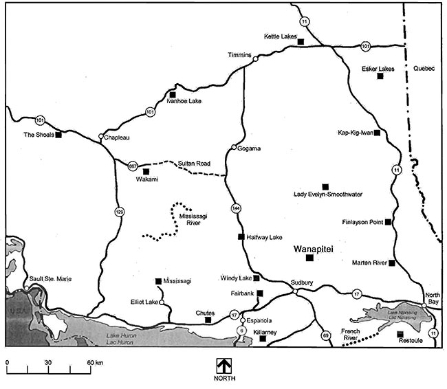
Enlarge Figure 1: Regional context
Note: This map is illustrative only. Do not rely on it as being a precise indicator of routes, locations of features, nor as a guide to navigation.
Figure 2: Park Boundary and Adjacent Areas
Enlarge Figure 2: Park Boundary And Adjacent Areas
6.0 Resource management policies
Wanapitei Provincial Park will be managed according to the Planning and Management Policies (1992, updates in 1998) for natural environment class parks and Ontario’s Living Legacy Land Use Strategy (1999).
6.1 Vegetation management
Vegetation in the park will be managed in keeping with natural vegetation succession processes. Vegetation will be managed to fulfill protection and recreation objectives.
Commercial forest operations are not permitted within the park.
Fuel wood cutting is not permitted.
6.1.1 Vegetation control
The removal of trees will occur, by Ministry staff, in high use areas where there is a threat to public safety and property or where it is necessary to meet the parks protection and recreation objectives.
6.1.2 Insects and disease
Insects and disease may be managed where aesthetic, cultural, or natural values are threatened.
If insect and disease management is required, guidelines established by the Ontario Ministry of Natural Resources and the Ontario Ministry of Environment will be implemented. Biological controls will be used in preference to chemicals where feasible.
6.1.3 Forest fire management
Forest fire protection occurring within the boundaries of the park will be implemented in accordance with the prevailing Fire Area Strategies. Protection from fire will be provided in all cases where life and property are threatened.
6.2 Water management
Lakes, streams and ground water quality may be monitored. Legislation and regulations are enforced by the Ministry of the Environment.
6.3 Fisheries management
Further research will determine the status of the parks' fishery (e.g. status of angling, fish populations). Prior to any changes in fisheries management or regulations further public consultation, in cooperation with the MNR District office, will be carried out.
6.3.1 Non-native fish introductions
Non-native species will not deliberately be introduced. Where they are already established, a management program for eradication may be developed, if it is practical or feasible for the perpetuation of the values for which the park was established.
6.3.2 Bait fish
Provincial park policy provides direction that prohibits the use or possession of bait fish in natural environment class parks.
In order to comply with provincial park policy and reduce the risk of accidental introductions regulations to prohibit the use of live bait may be established. (refer to Ontario Recreational Fishing Regulations Summary for definition of bait fish).
6.3.3 Sanctuaries
There are no sanctuaries within the park. Prior to establishing any sanctuaries further research (e.g. studies, assessments) may be carried out. Sanctuaries are established under the Fish and Wildlife Conservation Act.
6.3.4 Sport fishing
Sport fishing is permitted as per the Ontario Recreational Fishing Regulations Summary.
6.3.5 Commercial fishing and bait harvesting
Commercial bait harvesting occurs within Wanapitei Provincial Park.
Commercial fishing and bait harvesting is permitted to continue indefinitely, except in wilderness and nature reserve zones where these activities will be phased out by January 1, 2020. Zoning for the park will be determined through the park management planning process.
No new operations will be permitted.
6.3.6 Fish stocking
The Ministry may stock native fish into waters within natural environment class parks to rehabilitate the fishery and provide angling opportunities.
Stocking programs must avoid actions that would affect native populations.
Prior to any stocking activity a park management plan must be approved and the following should be considered:
- Whether it is permitted or not by planning and management policies
- Whether a take has been stocked in the past and current population is depleted from high fishing pressure
- Whether lakes have been stocked and the existing population is reproducing naturally
- Whether a lakes fish population has been affected by acidification or other catastrophic event
- Whether a lake contains sufficient forage base, depth and suitable spawning habitat
6.4 Wildlife management
Further research may be conducted to address the management of wildlife within the park.
6.4.1 Public safety
Animals compromising public safety may be subject to control measures. Select controls of animal populations will be implemented under the strict supervision of the Park Superintendent, or directly by, the Ontario Ministry of Natural Resources. Such control will only be directed at populations requiring attention.
6.4.2 Hunting
As per Ontario Regulation 83/85 under the Game & Fish Act (now the Fish & Wildlife Conservation Act, sport hunting is not permitted within Wanapitei Provincial Park.
Status Indians exercising treaty rights are permitted to continue hunting within the park.
6.4.3 Trapping
Commercial fur harvesting occurs within Wanapitei Provincial Park.
Commercial fur harvesting within the park will continue except in nature reserve and wilderness zones where these activities will be phased out by December 31, 2009. Zoning will be determined through future park management planning.
New operations including trap line cabins and trails will not be permitted. The relocation of existing trails and cabins will be subject to ecological principles and management planning.
If a commercial license is revoked or surrendered, all portions of the registered trap line within the park will be rescinded from the trap line’s legal description.
First Nations harvesting
Status Indians exercising treaty rights are permitted to continue commercial fur harvesting, subject to applicable legislation and regulation.
Transfer of trap lines is permitted only between Status Indians. Only Status Indian trappers' helpers are permitted to assist Status Indian trappers.
6.4.4 Bear Management Areas (BMA)
New BMA licenses will not be issued in Wanapitei Provincial Park.
An existing authorized BMA license may be renewed or transferred except in nature reserve and wilderness zones. Zoning will be determined through the park management planning process. The renewal and transfer of BMA licenses will be addressed through park management planning and will consider conservation principles and public safety.
6.5 Mineral exploration
Prospecting or the staking out of claims or the development of mineral interest is not permitted.
6.6 Land management
Wanapitei Provincial Park has many striking geomorphological features. Some of these include kame hills, esker ridges, outwash sand plains, bluffs and meandering river features.
Further assessment of the significance of landforms in the park is required.
6.6.1 Erosion
Within the park there is extensive bluff erosion on the shoreline of Wanapitei Lake. Discussions with Ministry of Northern Development and Mines indicate that shoreline conditions will stabilize inshore and develop from the present location. This, however, is very long term and relates to water level fluctuations caused by the dam at the outlet to Wanapitei Lake.
6.6.2 Cottage lots
There are no patent cottage lots in the park. No new cottage lots will be sold.
6.6.3 Land disposition
No new sales of Crown land for the private use of individuals or corporations will be permitted.
6.6.4 Private recreational camps
There are no Land Use Permits issued within Wanapitei Provincial Park. Recreational camps (including hunt camps) will not be permitted within the park.
6.7 Adjacent land management
Areas adjacent to Wanapitei Provincial Park may have implications to park management. Detailed descriptions and policies related to these areas can be found in Ontario’s Living Legacy Land Use Strategy (1999).
6.7.1 Adjacent areas
The following are Living Legacy areas near the park (Figure 2):
Chiniquchi River North Area (E183r)
This enhance management area encompasses approximately 52,624 hectares and abuts the parks' north and east boundary.
This area is important to recreational, tourism and resource sector (forestry, mining) interests. Recreational activities include canoeing, fishing, hunting, snowmobiling and cross-country skiing. The area is road accessible with some remote areas providing excellent remote recreation opportunities.
Land use direction and resource management activities will be compatible with protecting the natural and recreational values of the area, including Wanapitei Provincial Park.
Wolf Lake Old Growth Forest (F175)
This forest reserve of approximately 4,099 hectares contains the largest contiguous area of red pine "working group" stands older than 140 years in Site Region 4E. This may be the largest remaining contiguous old growth red 'pine dominated forest in Ontario.
This area is located northeast of Wanapitei Provincial Park.
Wolf Lake has high recreational values, being situated along the Matagamasi to Chiniguchi Lake canoe route and snowmobile route.
Reserve areas not under mining tenure will be regulated as part of the proposed Chiniguchi Provincial Park. Private properties are not included in this area.
6.7.2 Forest operations
Adjacent forest management will be regulated through the forest management planning process (FMP). Park values concerning planned access will be identified in the FMP.
Forest management interests, MNR, the Park Superintendent and other agencies will work together to ensure that adjacent land uses (e.g. forestry, recreational uses) do not affect the park environment (e.g. water quality, aesthetic value and natural/cultural features) and park visitor experiences now or in the future.
6.7.3 Access
Access to the park is mainly be motorized vehicles, on the Portelance and Mackelcan roads from Lake Wanapitei and by aircraft landing on the lake and river. Future management planning will address access management.
7.0 Operations policies
7.1 Recreation management
All recreation activities may be monitored to determine if controls (e.g. camping, trail use) are necessary to protect park values.
7.1.1 Motorized travel
Snowmobiles
Snowmobiles are permitted on the authorized trails and road allowances within the park, as long as this use is compatible with environmental values and other recreational uses. Trails and this activity will be reviewed during the park management planning process.
All-terrain vehicles
The use of ATVs may be permitted in development and access zones. The use of ATVs and zoning will be determined through future park management planning.
There are no authorized trails within the park, however ATVs will be permitted to use road allowances, subject to future park management planning.
Motorboats
The use of motorboats within Wanapitei Provincial Park is permitted, subject to zoning. Future park management planning will assess this use.
Aircraft (water)
Aircraft landing may be permitted in development, access zones and natural environment zones by commercial tourism operations. Aircraft landing may be permitted in access zones by private operators. Zoning will be determined through future park management planning.
In the interim, aircraft landing will be permitted.
Recreational watercraft
Future park management planning will assess/address use management.
7.1.2 Camping
Wanapitei is a non-operating park and there are no designated campsites or camping fees at this time. Camping within the park will be subject to the Provincial Parks Act.
7.2 Trailer dumping
This is a non-operating park with no services or facilities. Park users are responsible for disposing of grey water and sewage at local facilities.
Park users who dispose of grey water and sewage within the park may be charged.
7.3 Landfill site
The Aylmer landfill site is located to the north of the park and Sudbury District MNR is taking steps to close this site. The Sudbury District MNR will work with Ontario Parks to address the issues associated with closing is landfill.
The appropriate steps to close this landfill, as per the Ministry of the Environment, will be followed by MNR.
This is a non-operating park with no services or facilities. Park users will be responsible for taking their garbage with them.
7.4 Roads
Decisions on new roads within the park will be made during the park management planning process.
The existing access road to the park requires maintenance. This is not a park road and as such will not be maintained by Ontario Parks.
Existing roads within the park are not maintained and their use will be determined during the park management planning process.
7.5 Development
There are no facilities in the park. Wanapitei Provincial Park is a non-operating park therefore no development will occur at this time. A park management plan is required prior to any development.
7.5.1 Docks or improvements
There are no Land Use Permits for docks or improvements. Any dock structure or improvement on park land is considered an unauthorized occupation.
7.6 Commercial tourism
Only authorized tourism operations are permitted to continue within a park, subject to park management planning. No existing authorized tourism operations occur in Wanapitei Provincial Park.
No new tourism operations will be permitted.
7.7 Cultural resources management
There is limited information available on the cultural significance of this park. The original shoreline has been inundated as a result of the Ontario .Hydro dam development in 1929 which increased the water level by 3-4 metres. There are remains of a logging bridge, a small grave site, and a building foundation that appears to be of local significance. Further research is required to assess the significance of any cultural resources in the area.
Any significant values within the park will be protected.
7.8 First Nations
The Federal Government has recognized the Aboriginal land claim and is being reviewed by the Provincial Government. A communications protocol has been established between the Ministry of Natural Resources and the Wahnapitae First Nation.
First Nation representatives will be invited to participate in future park management planning and to bring the First Nation community perspective to that process.
Consultation and discussion with First Nations will focus on the principle of "due diligence" respecting infringement/affects, if any, on traditional lands, uses, and rights in terms of proposed management activities and undertakings within the planning area. Additionally, possible cooperative opportunities (e.g. inventory & value identification, stewardship/custodial arrangements) will be explored with the First Nation communities.
7.9 Natural Heritage Education
Wanapitei Provincial Park is a non-operating park and as such natural heritage education materials/programs will not be developed.
7.10 Research
Scientific research, by qualified individuals, that contributes to the knowledge of natural and cultural history and to environmental and recreational management, will be encouraged in the park. Ontario Parks will encourage institutions to undertake research projects. All research programs will require the approval of . Ontario Parks and will be subject to provincial park policy and other applicable Legislation. Ontario Parks may approve the research of any natural or cultural specimens by qualified researchers. All such materials removed remain the property of the Ontario Ministry of Natural Resources.
8.0 Implementation
This Interim Management Statement will guide the management of the park. Future park management planning will review broader resource management and development policies with the opportunity for public consultation.
9.0 References
Kor, P. 1975. Brief Geology and Geomorphology of Wanapitei Lake Park Reserve. OMNR.
Macdonald, I. 1980. Wanapitei Provincial Park: Life Science Features. OMNR.
OMNR, 1980. Wanapitei Provincial Park Background Information.
OMNR, 1992 (updates in 1998). Ontario Provincial Parks-Planning and Management Policies.
OMNR, 1999. Ontario’s Living Legacy Land Use Strategy.