Wasaga Beach Provincial Park Management Plan
This document provides policy direction for the protection, development and management of Wasaga Beach Provincial Park and its resources.
Wasaga Beach Provincial Park Master Plan June, 1978
Minister’s approval statement
Wasaga Beach, since the popular and widespread use of the automobile, has been one of the most popular recreation areas in Ontario. As one of the best swimming beaches in the province, Wasaga Beach has been magic to millions of visitors. Located completely within the Town of Wasaga Beach, the provincial scope and seasonal nature of the recreational resource became a problem for the local municipality. At the request of the community, the provincial government was asked to manage the beach and control the sun and fun seekers. Consequently, throughout the past decade a joint municipal and provincial program evolved for developing the Town of Wasaga Beach into a complete, serviced year-round resort community with Wasaga Beach Provincial Park playing a major role.
There are two distinct sections which comprise the provincial park; namely, the beach area and the dunes area. The beach area will provide a variety of water oriented recreational opportunities. Significant for its geomorphology and natural and cultural history, the dunes area through careful development will provide a further variety of extensive, and impact year-round recreation activities. Taken together the recreational, educational and research values of the resources make Wasaga Beach stand out as one of Ontario’s provincial parks that has gained significant recognition.
Throughout all the years of planning, the Ministry of Natural Resources has had continuous contact with the residents and representatives of Wasaga Beach, interested individuals and groups and other Ministries. The valuable advice and constructive criticism expressed are gratefully acknowledged and have been helpful during the preparation of the master plan.
In accordance with the Provincial Parks Act, Sections 1d and 7a, this master plan is approved as the official policy for the development and management of the park. The implementation of the Wasaga Beach Provincial Park Master Plan represents a key component of the commitment by the province to help the Town of Wasaga Beach develop as a viable recreation community for all seasons.
Signed by:
Hon. Frank S. Miller
Minister June, 1978
Highlights of the master plan
Wasaga Beach Provincial Park, contained completely within the Town of Wasaga Beach, is established to develop and manage 9.1 miles of fine public beach and to afford conservation and development of significant natural resources.
The Park is considered a key component of the commitment by the Government of Ontario to help Wasaga Beach develop as a viable recreation community.
Through a variety of areas, facilities and activities, the Park will attract short and long term visitors year round; through its role as a major industry in the Town (hiring up to 131 persons during peak operating periods) it will contribute to the economy of the Town; its facilities will provide opportunities for community oriented recreation.
The Park contains one of Ontario’s best swimming beaches, which will provide a variety of water oriented recreation opportunities to the people of Ontario.
The significant geomorphology of the Park, and its associated biology, will be conserved through the 2950 acre Dunes Area, which will also be partly developed to provide a further variety of extensive, and light impact recreation activities.
The educational and research values of these resources will be made available to the public and educational groups through a series of visitor services facilities and activities.
Wasaga Beach Provincial Park:
- significant in its role as a contribution to the goals of the Town of Wasaga Beach in becoming a viable recreation community
- significant as a provincial recreation resource, of fine sandy beach
- significant for its geomorphology, natural history and the related historical development
With these strong values, and the heavy populations and tourist potential of Southern Ontario, it will become one of Ontario’s major provincial parks.
The Park Goal To provide for the people of Ontario, and the community of Wasaga Beach, a wide variety of year-round recreational, interpretive, educational and scientific opportunities associated with recreation and natural resources of provincial significance, while contributing towards the economy of the recreation community.
The Park Objectives
- To maintain and further develop the beach for traditional beach day use (swimming and sun bathing) for the people of Southern Ontario.
- To create a wider variety of beach front oriented uses for day visitors, tourists, cottagers and residents.
- To provide the opportunity for extensive and space requiring recreation activities, in the “Dunes Area” in recognition of the natural significance and fragility of the area.
- To preserve a portion of a provincially significant natural system.
- To interpret to the public the various resources and stories of Wasaga Beach, especially as they are illustrated within the park areas.
- To provide opportunities for education groups at all levels to utilize the natural resources of Wasaga Beach Provincial Park for learning experiences.
- To provide opportunities for further scientific research of the natural system of the Wasaga Beach area.
- To attract tourists and day visitors to the Wasaga Beach community, help sustain their interest possibility prolonging their visit, or encouraging their return.
- To expand the seasons of use of the Wasaga Beach community changing the “peak weekends in summer” to a year round recreation community.
The Park
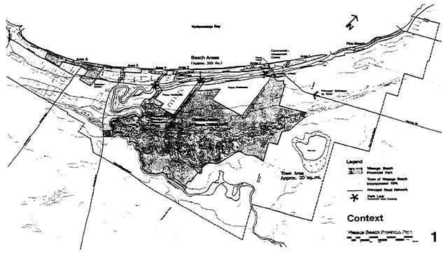
- 9.1 miles of beach, backed by Beach Areas of varying character, totalling 350 acres. From East to West, Allenwood Beach Area, New Wasaga Beach Area, The Point Beach Area, The Forum Beach Area, Dunkerron Beach Area, Schoonertown Beach Area, Oxbow Beach Area, Oakview Beach Area, and Springhurst Beach Area.
- Facilities include beach front boardwalks, walking trails, bicycle trails, creative play areas, open play spaces, grass and sand, informal court sports areas, amateur quality hard surface courts, picnic areas, family picnic shelters, an outdoor artificial ice rink, natural ice surfaces when weather permits, washrooms, change facilities and automobile parking.
- 2950 acres inland, including representation of a provincially significant geomorphological system of parabolic dunes and associated features.
- This Dunes Area will include a large Nature Reserve zone to conserve a section of the geomophological system. It will also provide (outside this zone) for extensive and space requiring recreation facilities and activities, such as automobile camping (300 sites in the snow-free season, 100 sites in winter), walk-in camping (25 sites), cross-country ski trails, snowmobile trails, hiking trails, access to canoeing and fishing on the Nottawasaga River, a snowmobile assembly warming area which becomes an equestrian assembly area in the non-snow season, group camping (for educational groups).
The park will also provide facilities, through its Visitor Services programme to help the user learn of the significant natural, cultural and recreational values of the area. Such facilities will include: an activity centre in the Oxbow Beach Area, the museum at Nancy Island, a visitor centre-education centre in the Dunes Area, a trails orientation centre, plus displays, exhibits and programmes in appropriate locations throughout the park.
Many people have been involved in planning for the Provincial Park at Wasaga Beach over a period of several years. This plan is a culmination of these efforts, and has involved the following personnel of the Ministry of Natural Resources.
Preliminary Master Plan
Project Team Chairman - J. A. van der Meer, District Parks Supervisor
E. C. Leonard, Landscape Architect R. H. Reynolds, Park Superintendent R. J. Carlisle, Resource Planner
L. T. Taylor, Resource Planner
W. Yetman, Visitor Services Programmer Master Plan
Project Team Chairman - J. A. van der Meer, District Parks Supervisor
- George, Regional Master Planner
- Calicher, Landscape Architect
- Hicks, Landscape Architect
- D. Parker, Park Superintendent
- Nuxoll, Visitor Services Programmer
Credit must be given to all those who gave support to the project team, particularly members of the Site Planning Unit and Huronia District Office, and those who gave direction to the project team, especially the Steering Committee chaired by John Featherston, Regional Parks and Recreation Areas Coordinator, and the Ministry of Treasury, Economics and Intergovernmental Affairs, Project Development Branch.
We gratefully acknowledge the participation of the Council and Planning Board of the Town of Wasaga Beach, and thank those who gave the effort of response to the Preliminary Master Plan, and the residents and visitors to Wasaga Beach with whom we have talked throughout the planning process.
1. Introduction
1.1 The planning process
Throughout this planning process, the Ministry of Natural Resources has had continuous contact with the Council and Planning Board of the Town of Wasaga Beach. Further, the staff of the planning team and the park have been involved in meetings and discussions, planned and spontaneous, with the residents of, and visitors to Wasaga Beach. Their desires, and requirements, and their reactions to our ideas have been constantly monitored and consulted throughout the process.
In addition to the above, this Ministry circulated a “Preliminary Master Plan” for the Wasaga Beach Provincial Park in September of 1974. This plan gave background resource and market information, developed a planning rationale and presented concepts for the development of the provincial park. Public response was invited prior to an extended deadline of January 7, 1975. Response was good, and generally very constructive. Branches and Divisions within this Ministry, other Ministries, Universities, professional associations, recreation and environmental associations, local municipalities, local clubs and groups, and individuals, all responded in written form to the preliminary plan.
Response took four directions, as follows.
- General commendation, with few specific comments.
- No comment. Although the idea seems interesting it does not concern me (us).
- The dunes area should provide more in the way of recreation (a specific item was more snowmobiling).
- The dunes area is a precious natural resource and should not provide for recreational activities. Its value is scientific and educational.
These categories do not, of course, cover all of the responses - some people had very specific comments on very specific items - however, they do represent the main impression of public response. That is, there are two poles to the question of dunes development, those wanting to fully preserve, and those wanting to fully utilize, with a third element of people who generally accept the plan as presented.
Many comments have promoted changes in the preliminary plan, consideration of new ideas, rejection of other ideas. But the planning quandary results from the polarity of public response, and the preserve vs. utilize question. This was not unexpected, as that same polarity exists in the resource and market analysis which shows that there are tremendous recreation pressures on significant and fragile resources.
This plan tries to recognize the need to provide for the recreation demand, at the same time as it provides for resource protection, although we recognize that neither the preservationist nor the complete recreationist will be pleased. The public in general, and the resource, will gain the most in terms of recreational experience, resource conservation, and scientific and educational benefit from the plans we present for Wasaga Beach Provincial Park.
1.2 Overview - a recreation community
Wasaga Beach, since the popular and widespread use of the automobile, has been one of the most popular destination points for recreation seekers in all of Ontario. The fine sandy beaches, shallow, clear waters of Georgian Bay and the Nottawasaga River have come together in a way which is magic to millions and which essentially is a natural base for a superb recreation resource. These resources have not gone unrecognized.
Wasaga Beach has always been a resort town catering to vacationers and has built an economic base upon recreation and the leisure dollar. For many years this base was seasonal with commercial operators trying to make a year’s living from Victoria Day to Labour Day. While this situation has improved recently with the widespread increase in winter sports, cross-country skiing and snowmobiling in particular, there remains an even greater, untapped potential for this community to function as a viable, year-round centre for recreational pursuits.
The situation, in the case of Wasaga Beach, is particularly unique, in that the last decade has produced dramatic changes. A little more than ten years ago, the Government of Ontario became involved in this area at the request of the Village to manage the beach and control the sun-and-fun seekers. At the same time, profound changes were becoming manifest in the values and trends of people in general. The demand for cottages, for places to go and things to do, was entering the upward swing of a long curve which has no visible end.
As provincial planners interpreted these trends and projections, they became more involved in the project and began to propose new, more far-reaching solution for handling people and problems in Wasaga Beach. The province’s earliest idea was to purchase all the land in a wide band paralleling the lake front and to create facilities and parking for the thousands of people visiting the area. Subsequent plans by the province and by consultants provided continual modifications to previous thinking. This included the 1967 Master Plan by Project Planning Associates, a Toronto consulting firm. This plan was far reaching in scope and quite impractical to implement, but it laid a better foundation for future planning. Further efforts by the local governments and the province culminated in the 1971 Progress Report which included a general master plan and embraced the concept of a “Park Community” at Wasaga Beach. The importance of this fact is that it set into motion the programmes for developing Wasaga Beach into a complete, serviced resort community with extensive park facilities by stages to the year 1990.
Throughout all these years of concerted planning effort, the residents and representatives of Wasaga Beach have voiced objection to the plans of the province. The loss of cottages and commercial establishments in order to provide land for provincial objectives without apparent measurable returns have been understandably difficult for the people of Wasaga Beach to accept. It has taken a long time to reach a stage which is barely a start, but at this time the differing and mutual objectives of both the community and the province are being realized, discussed and to a great extent respected.
The time is right and ripe to think of Wasaga Beach as being what it is: Unique; and to respond to the challenge of a rare opportunity to do what is best for the future of the community. The relationship here is unique in Ontario, possibly in Canada. In Banff, the town exists within the park, in Wasaga, the park within the town. However, it is not correct to think of the Provincial Park as an unwanted monster being forced upon the town. The park has now, and will have in the future, a strong role in providing recreational opportunities on a provincial scale. Furthermore, there are advantages in the presence of a large park within the town in that is permanently available to residents and that it will be an effective way of dealing with all the people who will continue to come to “The Beach” in years to come.
The time is upon us when a concerted effort must be made, based upon cooperation and understanding to confirm this town’s future as a community based upon recreation, or a “Recreation Community” as it has always strived to be.
The values and needs of the past are however, not always those of the present and future. Today’s plans must consider natural and cultural values; they must honour and retain the good things from the past; they must rationally consider the motives of the day, yet be ready as a flexible instrument for the impossible-to-see trends of tomorrow. This is no small task.
This Ministry, in preparing a plan for the provincial park at Wasaga Beach, has been by no means unmindful of this town’s heritage and for this reason has accepted the idea of a “recreation community” as being more accurate and meaningful than the term “Park Community”. While the Ministry of Natural Resources accepts many of the objectives set down in 1971 it should be clearly understood that this park has not been planned in a vacuum, but in parallel with the plans for the town and in consultation with the people and the official representatives of the Town of Wasaga Beach.
The concept of a Recreation Community provides for the following areas of development:
- Regional Development towards the goal of a year round recreational area.
- Service Development to furnish the area with a sewage treatment plant and central water system.
- Transportation Development to form a system of main access routes and to improve internal access circulation.
- Commercial Development to provide new and diversified commercial facilities and tourist amenities.
- Community Development to establish a viable community of residents permanent and seasonal and to ensure accommodation for tourists and visitors.
- Provincial Park Development which is the subject of this Master Plan.
Goals of the recreation community project
To provide for:
- A year round recreational area within a developing region as described in the proposed policy document, Design For Development: The Toronto Centred Region.
- The development of a large multi-faceted park integrated with a viable community of residents and supported by a complement of tourist facilities.
- The development of a residential community of seasonal and permanent residents provided with a good standard of necessary community services.
- The provision of commercial facilities, including recreational and tourist accommodations, in several distinct areas to serve the needs of the residents, tourists and day visitors from a wider area.
- The provision of a level of community and utility of services adequate for the needs of a substantial urban recreation area.
- The provision of a system of main roads to provide ready access to this and the surrounding area for residents and visitors from the region.
Progress Report March 1971, also recognized that “the Park, located mainly in areas requiring environmental protection and areas of prime recreational potential, is proposed to conserve the natural assets of the area and to provide a wide range of recreational activities for day-visitors, tourists, seasonal and permanent residents.”
2. Context
2.1 Location - setting
Wasaga Beach is a well-known recreation resort community ideally situated in Simcoe County at the southern end of Georgian Bay. It is easily accessible to millions of tourists and recreators and by virtue of its natural structure has become a popular destination for the last forty years.
Wasaga Beach Provincial Park is located entirely within the Town of Wasaga Beach. The Town, which was created on January 1, 1974 encompasses 20 square miles and incorporates, in its structure, the former Village of Wasaga Beach and annexed parts of Sunnidale, Nottawasaga and Flos Townships.
The Wasaga Beach area has been primarily noted for its beaches and for summer use, but the popularity of snowmobiling, the proximity of major ski areas and the favourable aspect of the area for snow suggests more significant potential for year round use than presently is shown.
2.2 Access
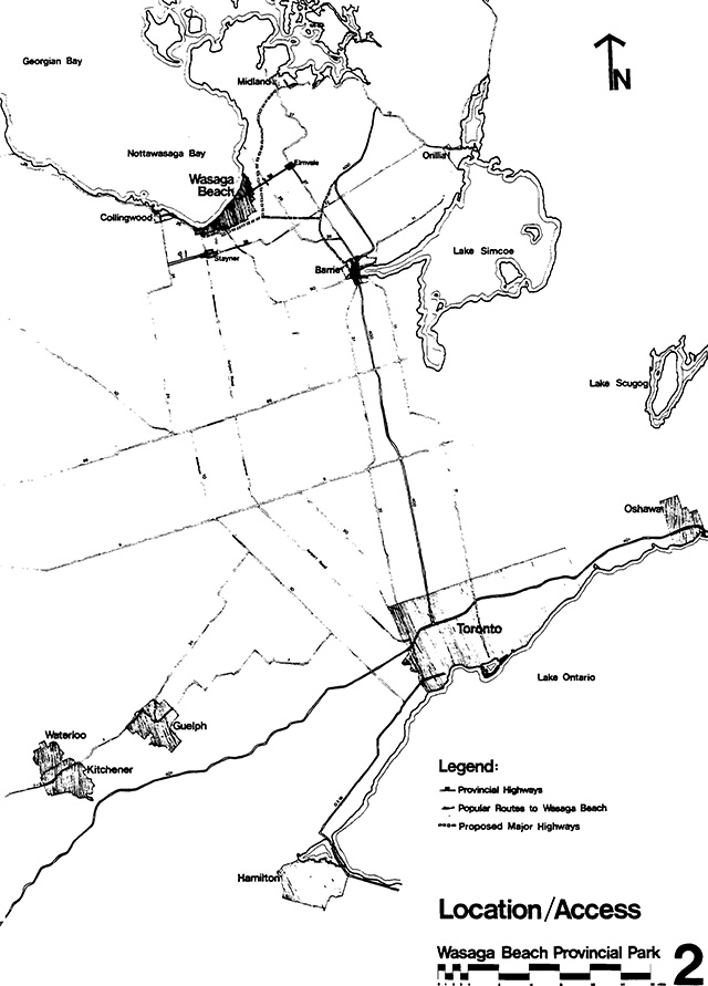
Wasaga Beach has only been accessible to travellers from southern Ontario and other parts of the Province since the late 1940’s and 50’s. Today, Ontario’s main north-south arteries, Highways 400 and 27 direct travellers to Wasaga Beach via Highways 92 and 26. The former leads directly to the resort’s present commercial core at the bridge terminus of Highway 92, and the latter directs traffic to Wasaga Beach via Byrnes Avenue and the cottage shores of Brock’s, Springhurst and Oakview Beaches.
Two access roads off Highway 26 are used by visitors more familiar with the area; Townline Road (County Road 7) and Sunnidale Road (County Road 10) provide direct access to the Springhurst, Oakview Beach and Oxbow Beach areas.
The Ministry of Transportation and Communications (M.T.C.) has completed two studies affecting the Wasaga Beach area.
- Highway Planning Study Barrie - Simcoe County
This plan deals with proposals affecting the Simcoe County region and specifically recommends:
- “a Barrie-Collingwood arterial is proposed to serve travel desires between Highway 400 and the Wasaga Beach, Stayner, Collingwood areas… and to provide a basic transportation corridor ..... The proposal involves expansion of Highway 92 and a new alignment of Highway 26 west from Highway 27 towards Collingwood. A route has been chosen for this Highway 26, but the commitment to build is considered in the long range by M.T.C. (After 1986).” Refer to Figure 3.
- “Wasaga Beach - Midland Highway: A new highway is recommended along the shore area of Nottawasaga Bay from Wasaga Bay to Midland. This proposal envisions a scenic or parkway route to be designed in harmony with recreational and environmental considerations of the area. Again this is a long range proposal. No route has been selected.”
- Feasibility Study February 1974
Internal Road System
This study deals with proposals and considerations related to local traffic systems. Those aspects which affect or influence the provincial park are outlined below.
- A major concern of the M.T.C. study is the expected need for a new or improved east-west arterial corridor south of the Nottawasaga River to relieve traffic loads on existing roads and to serve future community residential areas. In all, three alternatives have been investigated; the resultant choice being a limited access, “rural” type route entirely appropriate to the park setting proposed in this plan. This route consists of a new alignment south of River Road West, between the Schoonertown Bridge and Highway 92.
Figure 1 illustrates the proposed road network with the east west arterial route. - Overall Network
The Feasibility Study further recommends access to the Recreation Community via Highway 26 (new alignment) to the various collector roads: Townline Road (County Road 7), Sunnidale Road, Klondike Park Road to Powerline and Golf Course Roads and by means of the Eastern Access Road to Highway 92.
M.T.C. suggests that in later phases of planning of the Wasaga area, access to the central area may be necessary via Powerline Road.
Of all the internal improvements that M.T.C. proposes, the development of Powerline Road as an access route is the lowest priority.
This master plan recommends that Powerline Road be transferred to the province for immediate use as an internal park road with the understanding that long term requirements may result in its use as a public collector road.
For the short term, more emphasis should be placed on Sunnidale Road as a collector road and this Ministry consult with M.T.C. to consider alignment improvements to Golf Course Road. The Golf Course Road could be improved through cooperation of the Town, the Ministry of Natural Resources and Ministry of Transportation and Communications as a Park Access Road.
2.3 Market area
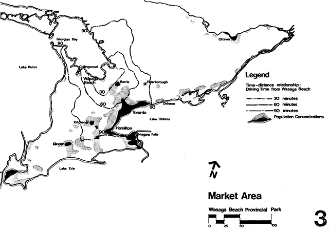
In this plan, it has been accepted that the distance which people can travel in two hours is a reasonable limit to achieve a day’s recreation experience. This does not include those on extended-period vacations who comprise much of the market to the Wasaga Beach region.
Approximately five million persons or 70% of Ontario’s population reside within this two hour range of Wasaga Beach. These people represent the basic potential market for short-term visitors to Wasaga Beach.
The population within this major market area is one of the greatest concentrations per unit area in Canada and is expected to increase by a rate of 32% by 1991.
2.4 Visitor use
Accessibility to the greatest number of people as well as the type and variety of facilities, and special characteristics of features of a Park affect the degree of use which that park experiences.
Traffic counters and numbers of permits sold at beach gates (over a ten year period) reveal that Wasaga Beach is akin to a teeming mobile city almost every weekend in the summer.
Beach user surveys conducted in 1962, 1967, 1970-73, indicate that the majority of visitors are day visitors from the Toronto area, that they have consciously chosen to visit Wasaga for a beach experience (sun, sand, and water), and that “people” are part of that experience.
Certainly Wasaga Beach fulfills the requirements of day-use demand in respect to resource character and availability, location and accessibility but, Wasaga Beach is also a resort town with many seasonal residences and tourist accommodations, and it is a permanent home for many more.
There are four basic categories of “users” of Wasaga Beach each having different needs and demands on Park and Community facilities within the categories of:
Residents
Cottagers (Seasonal Residents)
Tourists
Day Visitors,
there are groups of persons that require additional consideration. Of the permanent population of Wasaga Beach, 24% are senior citizens. This group is increasing in size and already gives Wasaga almost twice the Provincial average of residents over 60.
Family groups traditionally represent the largest user group in provincial parks and Wasaga Beach is ideally situated for family activity. Many of the seasonal residents, tourists and day visitors are family groups.
There are large numbers of groups representing various cultural backgrounds who use the beach both as seasonal residents and day users. Their traditions of recreational use add a new dimension to provincial park usage which must be considered.
Finally, Wasaga Beach has always been an attraction to the youth of the province (1625 years of age) who flock to the area on weekends to enjoy its amenities.
The identification and recognition of this variety of user groups and their characteristics necessitates great flexibility in planning for the use and enjoyment of the provincial park within the community.
Description of park users
1. Residents
Present statistics
Within the new Town of Wasaga Beach, there are approximately 4040 residents (1975).
Surveys indicate that many of the residents presently do not use the beach for active summer recreation. However, resident use over the past few years has increased with park beach development. Many residents participate in the winter recreation opportunities.
Trends
Projections for the future suggest about 10,500 permanent residents by 1986 (Progress Report 1971).
With a growing population, especially in the retired group and within the concepts of a Recreation Community, it appears the Province will have an increased responsibility towards the permanent residents at Wasaga Beach in facilities planned in the park.
Needs
At present, many residents are working in the recreation-tourist industry and have little time to become involved in recreational activities which are summer and day oriented.
There is a need to provide a variety of activities and facilities, land and water based, that will give the full range of age groups of residents an opportunity to become involved recreationally at different time of the day and throughout the year.
2. Cottagers (Seasonal Residents) Present Statistics
The estimated summer population of cottagers (1975) is 10,900 persons.
Surveys indicate considerable use of the beach by cottagers, principally during the week, but on weekends also.
Trends
Projections for the future range as high as 25,000 seasonal cottagers but these estimates are subject to revisions within the Official Plan for the Town. More and more of the summer cottages are being winterized and there is an increasing trend towards year-round use of residences by their owners. Many express a desire to participate in local events and many seek to eventually retire in the Town of Wasaga Beach. This trend generally means a growth of the “resident” group, balanced by a reduction of “seasonal ”numbers.
Needs
Accessibility to the beach is of prime concern to most cottagers. Availability of a variety of activities and facilities, land and water based, for all age groups, information concerning regional attraction and programmes designed to encourage involvement of seasonal residents in local activities are recognized as requirements which can be met most effectively through cooperation between park and community recreation programmers.
3. Tourists
Present statistics
A number of privately owned cottages are rented on a weekly basis during the summer. It is estimated that there are commercial cottages, motel and hotel accommodations for between 3,500 and 5,000 persons in Wasaga Beach at this time. There are 14 private campgrounds offering 985 campsites within ten miles of Wasaga Beach.
Trends
Future projections estimate as many as 14,000 tourists accommodated on a peak day by 1986 (Progress Report 1971). Changing trends in leisure time will no doubt affect the tourist industry, but plans within Wasaga Beach Recreation Community will remain as flexible and sensitive as possible to changes in demands and preferences.
Many accommodations are winterized to provide facilities for the increasing trend towards year-round recreational activities.
Needs
Tourists most commonly seek out points of interest in and around their destination. The provincial park should provide a wide variety of recreational and educational activities, opportunities and facilities as well as providing information on additional events, and attractions in the community and vicinity.
4. Day users
Present statistics
From the 1970 Beach User Survey, (Sunday, August 9, 1970) 68% of those surveyed were day-users and 62% of the visitors came from Toronto. A survey conducted on Sunday, July 30, 1972, showed that 59% of the users were day-users and 44% were from Toronto.
Licence plate surveys in 1973 showed that on holiday weekends, between 63% and 64% of cars in the park had Toronto issued licence plates.
These percentages represent several thousand persons at any one time from a given origin. The nature of counting varies greatly between traffic counters (24 hour periods), permit sales (8 hours) and sample surveys, but interpolation and market area studies indicate that Wasaga should be prepared to handle over one million visitors in a single season.
Trends
The current attraction for day-users at Wasaga Beach is the beach itself. Two hours driving time represents the time most people will travel to achieve a day’s recreation activity and this range from Wasaga Beach presently encompasses five million persons. Day use demand will conceivably increase at the same rate as population growth or 3.4% per year.
Even with high water levels drastically reducing the amount of beach available to visitors, the total recorded attendance at Wasaga Beach Provincial Park in 1973 was still greater than at all other provincial parks in Ontario except Pinery and Algonquin.
Facilities developed within the park will provide for the needs of large numbers of day visitors. To meet the projected peak demand (as high as 35,000 people in one day) without usurping vital space, requires meaningful information systems, alternative transportation methods, flexibility and multiple-use potential in park areas to minimize pressures on the community.
Needs
Presently, the day-user is attracted to Wasaga Beach by the beach itself in search of sun, sand and water-oriented experience and in search of social interaction. Basic facilities required are parking, washrooms, change-houses, concessions (refreshments), and shelters.
A more significant effort will be made to promote day-uses at times other than the summer and to complement the community in providing recreational activities and opportunities for a wide spectrum of people and interests.
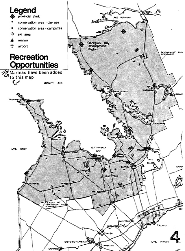
2.5 Other opportunities
Intervening
Assuming that the Toronto-centred Region is a major source of people seeking a beach experience, and that two hours represents the time they will travel to achieve a day’s recreation, it can be shown that Wasaga Beach offers 70% of the supply of provincial park bathing beaches available to this market. Fourteen other provincial parks within two hours of Toronto offer a total of 3.9 miles of public beach, Wasaga alone offers 9.1 miles. In other words, there are not many areas that will intervene between the user and a beach experience at Wasaga Beach.
Complementary
Simcoe County is promoted by the Huronia Tourist Association as having a significant number of tourist attractions, ranging from historic sites, museums, and zoos to other provincial parks, Conservation Authority Areas, natural areas, recreational facilities, commercial attractions and accommodation facilities including hotels, motels and private campgrounds. Rather than detract from the tourist and recreation potential of Wasaga Beach, this wealth of available features enhances the role of Wasaga Beach as both a destination and as a centre from which to visit other attractions in the region.
3. Resources
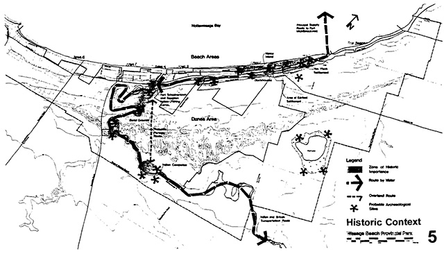
3.1 Cultural resources
Early history
Historically, the Nottawasaga River has been a main artery of man’s activities. Initial human activity in the Wasaga Beach Area probably occurred during the Archaic Cultural Period (5000-1000 B.C.).
Archaeological evidence of Saugeen Indian fishing encampments along the Nottawasaga River has been recorded within the park. These people occupied areas of Southwestern Ontario about 2000 years ago.
No direct evidence has been found to indicate that Huron or Petun people used the area’s resources as part of their subsistence pattern; however, it is known historically that Huron’s often travelled through this area on their way to Petun country.
During the latter historic period, Algonquian people who had moved into areas abandoned by the Ontario Iroquois (Huron and Petun) used the River for transportation and for fishing.
The first European influence on the area also centred on the River. British fur trade and military supply routes to the northwest followed along the Nottawasaga River into the bay and north to the Fort Michilimackinac.
During the War of 1812, the British schooner HMS Nancy was sunk at the mouth of the river by three US ships and a small garrison was built by the British at Schoonertown in 1814-15. However, when Pentanguishene became a focal point for the military, Schoonertown faded and the Nottawasaga River became less important as a transportation route.
Nineteenth century entrepreneurs logged white pine from the dunes and the beach. At least five sawmills were operating in the Wasaga area between the 1830’s and 1890’s. The shallowness of the river and sandbars in the Oxbow area created transportation problems for ships. When the railway bypassed Wasaga Beach for Collingwood in 1855 hopes and prospects for industrial development ended.
When the beach had been cleared of its white pine, it became a long, narrow sandy roadway.
Recent history
During the 1920’s and 1930’s little development took place. The first paved road (now Highway 26) did not approach Wasaga Beach until 1930, and even then this was a single-lane road. A second lane was added in 1947. However, Highway 92 (Elmvale to Wasaga Beach bridge)was paved in 1940 and the root of traffic congestion was extended.
Then the influx of soldiers from Camp Borden during World War II and widespread availability of the automobile started a trend to increasing day-use and wild weekend sprees. Inexpensive tourist cabins and hundreds of cottages spread along the beach. Finally, the construction of Highway 400 during the early 1950’s brought more and more day-visitors from Toronto and surrounding areas. The resort was transformed into a melange of hotels, motels and amusement centres interspread with cottages, cabins, variety stores and snack bars.
The following quote, written by R. Wolfe in Recreation in Ontario., University of Toronto., 1948, summarizes the development of Wasaga Beach. It could have been written very recently.
The present state of affairs is the inevitable result of the resort’s haphazard and unpremeditated growth. It is equally the result of the fact that Wasaga Beach is purely a summer resort, and nothing else.
And this further quote from R. Wolfe, 1948, applied until the summer of 1973, when the Ministry of Natural Resources finally removed automobile traffic from the beach.
The most obvious disability that Wasaga labours under, and the one that disturbs thoughtful visitors most strongly, is the inadequacy of the road system --- that has turned the resort’s chief asset, its splendid beach, into the hazardous., odorous highway it has become.
In 1962-63 the Village of Wasaga Beach and Townships of Sunnidale and Nottawasaga, requested from the Ontario Government assistance in the management of the beach. In 1967, the Province commissioned a firm of consultants to recommend future direction for the community. In 1971, direction had been established and government commitment to aid to the development of Wasaga Beach as a year-round recreation community was outlined in Wasaga Park Community Project: Progress Report 1971.
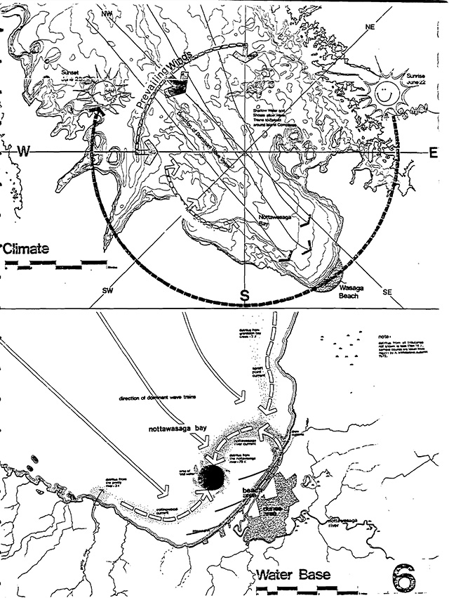
3.2 Natural resources
Water
Wasaga Beach lies at the head of Nottawasaga Bay, where clean waters are a major attraction for swimmers. Up to six parallel sets of sand bars render the water shallow, enabling bathers to wade and swim safely sometimes hundreds of feet into the bay. Shallow waters warm easily making the cool waters of the bay even more pleasant for bathing.
The Great Lakes are subject to water level changes which occur at irregular intervals. These levels have a great effect on the width of the dry beach at Wasaga because of its long, gentle slope. Old timers remember two or three periods when the beach was as narrow as in 1973, but they also remember when the dry beach was over two hundred feet wide. It will, no doubt, continue these cycles.
The Nottawasaga River empties into Nottawasaga Bay at Wasaga Beach, its waters murky with suspended sands, clays and organic matter. The organic matter settles into troughs in Nottawasaga Bay, to be churned up during storms and deposited by currents along the beach. This muck or detritus, studied by the Ministry in 1972, was found to be composed of natural materials (leaves and twigs, partially decomposed). Unsightly and unpleasant to wade through, it is, however, no pollution hazard, only a management problem.
Studies of raised beaches (Martini) show lenses of what appears to be “muck”, indicating that this process has gone on at least for the last 3000 years.
The Nottawasaga River is important as a sports fishery, utilized heavily by anglers, spring, summer and fall. They fish from the banks, from canoes and rowboats and near the mouth from power boats.
The Nottawasaga River, historically a major transportation route, is now becoming popular as a canoe route, both for casual trips and for races.
Climate
Weather is one of the contributing factors to the attractivity of Wasaga Beach.
The climate is generally the same as that of most Southern Ontario - mid-latitude, humid continental; however, it is locally moderated by prevailing winds blowing on-shore across a vast expanse of Georgian Bay waters. This results in generally cooler summer temperatures, warmer and snowier winters, and a long cool spring.
Spectacular sunsets and cloud formations are visible regularly as the sun sets over the bay in summer and moves toward Blue Mountain, silhouetting the Niagara Escarpment in fall and winter.
Mild sunny weather complements the shallow, sloping shores of fine sand and the clear, clean waters of the bay, rendering Wasaga Beach one of the finest public bathing beaches in the Province.
People, however, may react differently to the heat in the dunes. In the summertime, open prairie areas often have ground temperatures approaching 130°F and even the forested dunes may achieve ground temperatures of 120°F. Very hot ground and hot still air can make the foredunes and parabolic dunes areas very uncomfortable in the summer. Spring, fall and winter, are different stories. Moderate temperatures and tree-stilled air help make these areas aesthetically very pleasing for the walker, snowshoer, or cross-country skier.
Geology and geomorphology
Evolution
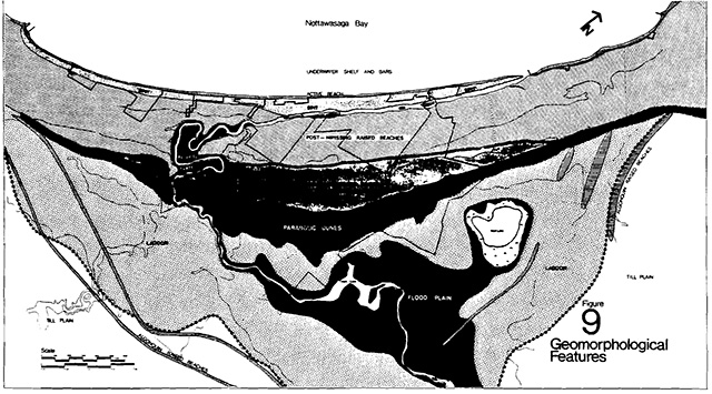
Bedrock plays only a minor role in the geohistory of Wasaga. The Wasaga Beach geomorphological system is a result of the power of wind and the movement of water shaping and reshaping the debris (a pre-Algonquin till sheet) left behind by the last Pleistocene ice advance in the area (Wisconsin glaciers).
The following process is modified from two papers by I.P. Martini, University of Guelph. Please use Figure 7 see the relationship between time periods, and the lake levels.
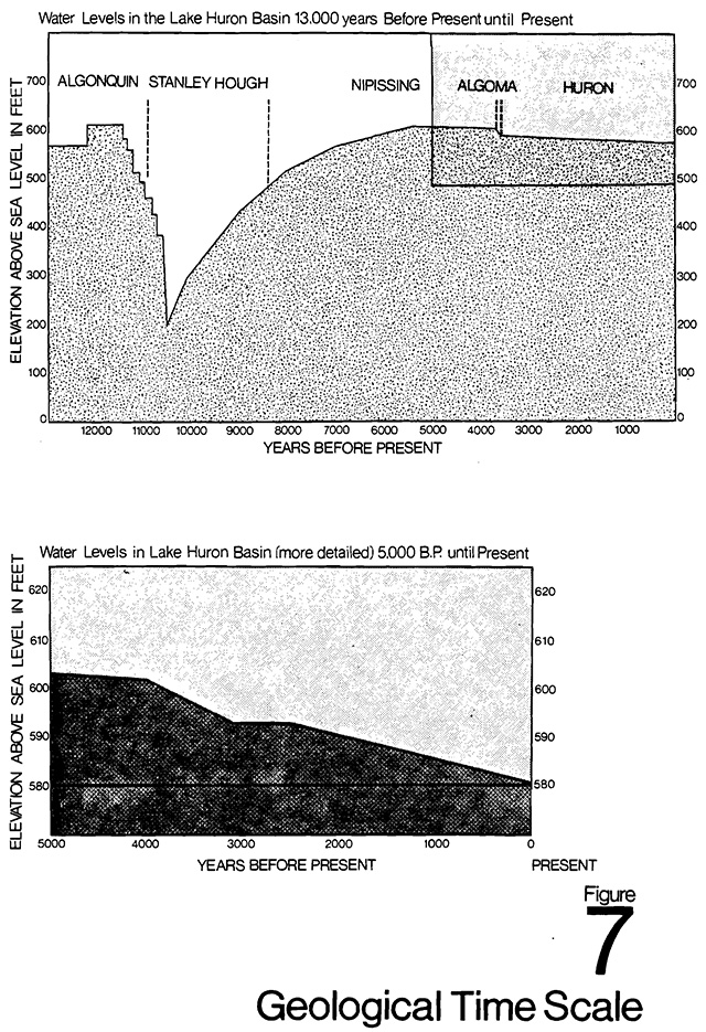
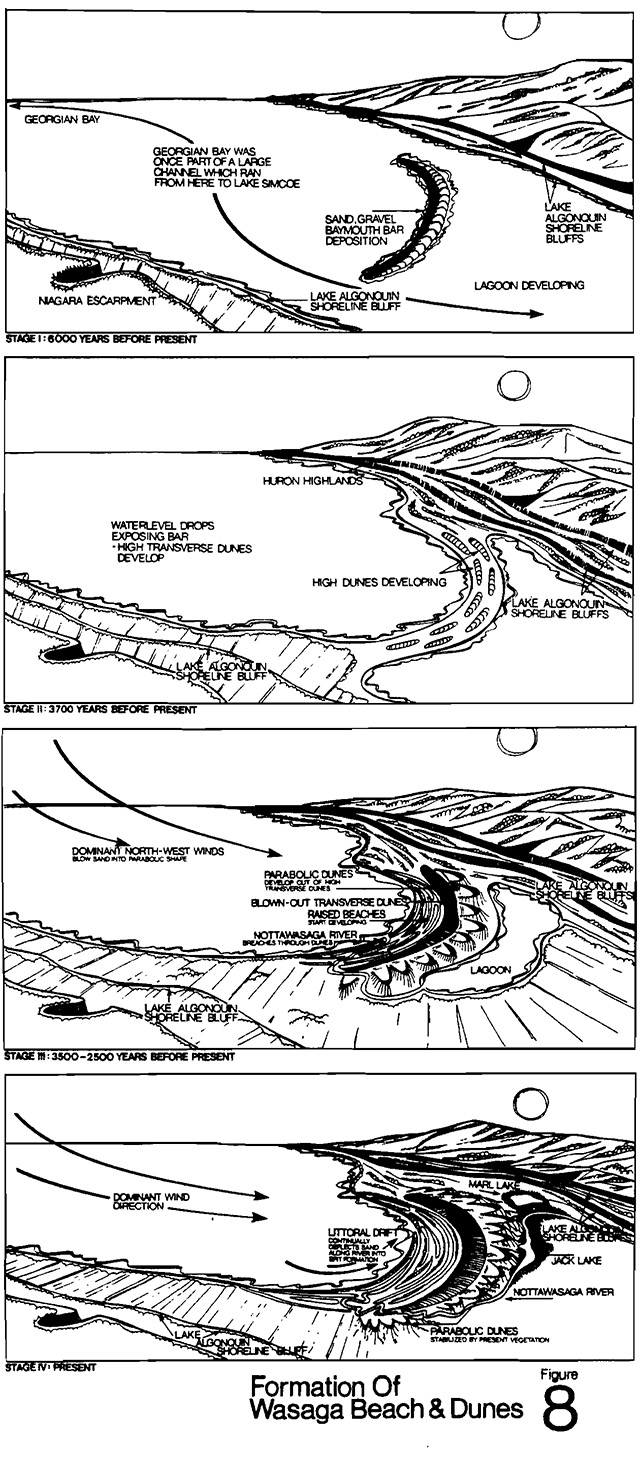
Components of the system
The Wasaga Beach area, then, represents a geomorphological system associated with glacial and post glacial lakes, and the development of a barrier complex. This complex has seven major elements.
- Pre-Algonquin till sheet and spillway of Lake Algonquin
These features are not generally in evidence within the Town of Wasaga Beach, but comprise the major landform to the south. One cut in the river shows evidence of the till. - Algonquin Raised Beaches
Three Algonquin Beach lines are recognizable within the Town of Wasaga Beach. - Nipissing Lagoon
Low flat areas of marl or lagoon sediment, now occupied by Jack’s Lake, Mark Lake and surrounding farm fields and woodlots. - Barrier Island - High Dunes Area
An area of foredunes (and blown out transverse dunes) that undulate randomly inland of the raised beaches, and
A band of large, parabolic or U shaped dunes that often exceed 100 feet in vertical relief. - Post Nipissing Raised Beaches
A band of parallel recurring ridges and swales extending northward from the dunes field. The ridges are often topped with small, parallel dunes. - The River channel, floodplain and alluvial flats
An area of sediment reworked by the Nottawasaga River. - Recent Sandy Environments
The present beach, the underwater and sand shelf and bars the river-lake interface area (spit) and active, developing blowouts in the dunes are ongoing processes in the continuing evolution of this barrier complex.
Of these components, all except the Algonquin raised beaches are present within the Provincial Park boundaries (The pre-Algonquin till sheet is represented in one river cut.).
Biology
Flora
Botanists (Cuddy, Carlisle, Norman) have identified twenty-six biological communities within the geomorphological system of Wasaga Beach. Of these, twenty-two occur within the boundaries of the dune parkas illustrated in Figure 10.
A study by R.S.W. Bobbette of his own work and other known collections, identifies 611 species within the boundaries of the town. Most of these also occur within the park.
These communities occur in close association with components of the geomorphological system. The raised beaches exhibit a striking pattern of dry vegetation on the ridges and wet bog communities in the swales. The vegetation in the dunes varies from open desert (blowouts) through prairie, prairie heath, and savannah to closed forest cover. Many of the dunes species are native xeric species, pre-adapted colonizers of dry sands.
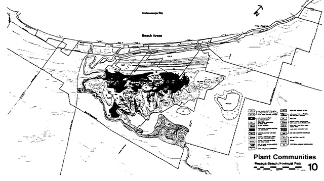
The floodplain and river basin areas contain typical floodplain - meadow and forest species.
Only the farmed fields and two pine plantations are major deviations from natural development systems.
Many of the communities and species now existing in the dunes fields are not common in Ontario, and appear to have held on to this sandy dry area from a period perhaps 4,000 years in the past when climatic conditions were much drier. And while the normal undisturbed succession process (something that almost never happens) would suggest that all of the prairie should now have advanced to full closed forest, botanists suggest that frequent fires (both natural and human origin) have been instrumental in maintaining the vegetative communities of Wasaga Beach in all stages of succession.
Fauna
Detailed faunal studies have not been carried out for the Wasaga Beach area, but will be, as part of the operation of the park. The variety of habitats should give rise to an interesting variety of species, but to date, no unusual or rare species have been identified. Normal species of small mammals are found (chipmunks, squirrels, mice, rabbits, raccoons, etc.).
Deer do not normally “overwinter” in this area, but in the late summer and fall they do feed in the dunes and along the river.
Historic and recent records identify 218 species of birds in the immediate vicinity of Wasaga Beach (that is, within the new boundaries of the Town) This variety of species results from a variety of environments, the dominant of which are the shore, the marshes of Marl and Jack Lakes, and the dry, forested dunes. Adjacent Georgian Bay plays an influential role as well, with Wasaga Beach and the Nottawasaga River as part of a Bay flyway.
Past nesting records of Prairie warbler and Piping plover, sometimes in surprising numbers, are not being repeated in recent years. Perhaps increased human activity has influenced the activities of these sensitive species, but it is also possible that Wasaga’s recent image is not one that attracts naturalists and bird watchers, and records are not made because qualified people are not visiting the beach regularly to view bird life.
Hopefully, new enthusiasm will help complete and maintain species records at the Beach.
The Nottawasaga River is a very important recreational fishing source in Southern Ontario, pickerel and trout being the most notable and commonly sought by fishermen.
3.3 Development constraints
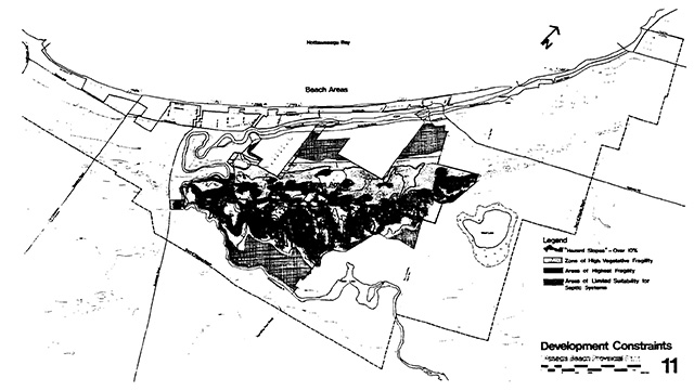
Vegetative fragility
A study (Sealey) in the summer and fall of 1973 investigated the twenty-one plant communities found within the Dune Park (see Figure 10). Careful evaluation was given to each species in a community, on the basis of relative numbers, rate of recovery if disturbed, aesthetics, role of the species in the presence of other species and so on. After all species in a community were evaluated, and given a numerical rating, their values were totalled to give a community fragility rating. Figure 11 indicates only the four most fragile communities within the Wasaga dunes system.
It is important to note that almost all of the communities would rank in the top 20% of a provincial ranking system. In short, with very little use, the biological communities of the Dunes park will be destroyed or seriously modified.
This conclusion is based on research by a University of Guelph graduate student in which a number of ground cover sites were subjected to different amounts of trampling. In some areas as few as eight trips per day for three weeks will destroy all ground cover, exposing bare sand.
Slope
The dunes are made up of unconsolidated sands, which, having been positioned where they are by wind sorting, are subject to further wind movement if exposed.
In the larger dunes, many of the slopes approach the natural angle of repose for sand of this shape and size; that is, the steepest angle that sand can rest at without starting to move by gravity.
The steepness of slopes, fragility of vegetative cover stabilizing slopes, and the propensity of the unconsolidated sands to wind movement all suggest that hillsides (dune sides) are more fragile and subject to deterioration through excessive use than the flatter areas.
Water table
With only a slight elevation above Georgian Bay and the Nottawasaga River, much of the land has a high water table, especially the raised beaches and lagoon areas. This places constraints on installation of septic systems, construction and maintenance of some facilities (such as roads), and general desirability for recreation activities.
Existing development
While the Dunes Area of the park is relatively natural in appearance, it has undergone some development, or been subjected to some utilization. These changes are manifested by road and hydro cuts, plantations, excavations and other remnants of other human activities.
4. Resource evaluation
4.1 Significance of the resources of Wasaga Beach
The following is a description of the significance of the various resources of Wasaga Beach:
Geomorphology
There are other baymouth bar systems on the Great Lakes. None, however, show the combination of raised beaches, foredunes and parabolic dunes to the extent of Wasaga Beach.
There is one other similar set of raised beaches on the Great Lakes, near Ipperwash on Lake Huron. It is not under Crown ownership.
Wasaga Beach has the largest known set of parabolic dunes in Ontario. Even compared to other sets of large dunes of different types, these are some of the least disturbed by man’s activity.
The foredunes (blown out high transverse dunes), 10 to 20 feet high, are not unlike general dune systems anywhere in the Great Lakes. Both the foredunes and parabolic dunes are composed of unconsolidated windblown sands. If vegetative cover is disturbed, these sands are subject to further movement by the wind.
Lagoon sequences, floodplains and the river’s edge are not unlike many similar features elsewhere. Their significance lies in their relationship to other features as part of a geomorphological system.
The dunes area of the park, unsuitable for agriculture and not yet subjected to residential development is still a fairly natural area.
Biology
The whole area exhibits a strong visible relationship between the geology and biology {especially in the raised beaches).
There are many interesting species here. Many are uncommon in Southern Ontario, but abundant in the Wasaga Beach area. Some are species found only in special habitats. They are limited in distribution. Some are northern species that have their southernmost station here; some are western species with their eastern most station here.
A wide variety of conditions (swamp to high dune) gives rise to a large number of species.
Some communities such as prairie and prairie heath, which are not commonly found in Ontario are represented here in the foredune area.
A sequence of communities and species exists from bare sand to closed forest. This sequence has probably existed continuously, maintained by fires and other natural disturbances.
If completely protected, this sequence probably would, through succession, evolve completely to closed forest. Such “completed protection may not be desirable, or even possible.”
History
The prehistory of the Wasaga Beach area is still speculative. Archaeological surveys are not complete. However, preliminary indications show that the Wasaga Area was repeatedly used by different native cultures.
Military and town development history of Wasaga Beach is of regional significance.
Recreation
The development of Wasaga Beach as a recreation resource is of provincial significance.
The Beach, stable, gently sloping and very long, is one of the great beaches on the Great Lakes.
The river is at least regionally significant as a sports fishery, and is gaining importance as a recreational canoeing route.
4.2 Management units
The Dunes Area of Wasaga Beach Provincial Park as described in the preceding sections, is little known, highly complex and extremely delicate. This condition suggests that “the dunes” be carefully analyzed and more carefully planned to ensure that “the provision of a wide variety of recreational possibilities” as stated in the park goal does not jeopardize the existence of irretrievable natural resources. While it is not economically or practically possible to own and selectively protect or develop all of the dunes, the lands proposed for the park do offer potential for both.
The process of analysis to determine selected use potentials for an area has produced Management Units. These units are basically more workable subsections of the geomorphological features and are determined by specific natural factors such as biology, water table, drainage and slope or by artificial factors such as boundaries and human interference in the landscape. Figure 13 locates these units and indicates a potential degree of development for each (as described in section 4.4.) The management units are listed and described in the following sections.
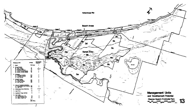
| Management unit | Acreage | Development potential see potential see section 4.4 |
|---|---|---|
| 1. Beach-spit-shelf | 280 | 3 |
| 2. Raised Beaches | N/A | N/A |
| 2a. Ross' Hoods | 30 | 2 |
| 2b. Oakview Hoods | 40 | 2 to 4 |
| 2c. Racetrack Section | 35 | 4 |
| 2d. Central Raised Beaches | 120 | 1 |
| 2e. Eastern Raised Beaches | 80 | 2 |
| 3. Foredunes | N/A | N/A |
| 3a. Racetrack Section | 210 | 4 |
| 3b. Foredunes Section | 460 | 1 |
|
3c. East Section |
300 | 2 |
| 4. Parabolic Dunes | N/A | N/A |
| 4a. West Section | 200 | 2 |
| 4b. Central Section | 480 | 1 |
| 4c. East Section | 300 | 2 |
| 5. Areas of Lagoonal Sediments | N/A | N/A |
| 5a. Nottawasaga River Section | 315 | 3 |
|
5b. Sage Farm Section |
140 |
3 |
| 6. Nottawasaga River Shoreline | 130 | 2 to 4 |
| 7. Sand Plain | 40 | 3 |
| 8. Geological Cross Section | 25 | 1 |
| 9. Park Links | N/A | N/A |
| 9a. Schoonertown Link | 15 | 4 |
| 9b. Powerline-Joan Link | 60 | 4 |
| 9c. Nancy Island Link | 40 | 4 |
| Total | 3,300 Acres | N/A |
4.3 Unit descriptions
1. The beach - spit - shelf
The nine miles of long, wide, sandy, shallow beach, with up to six submerged sand bars, is rated as a Class I Recreation resource (according to the Ontario Land Inventory 1966 to 1969.)
It is safe for swimming along its whole length except at the Point where river currents create dangerous undertows. It is this one small section, too, which is unstable, subject to changes in shape from the river currents. The remainder is a stable active beach.
By nature, the beach does not have much vegetation. This situation has been reinforced by past use and development, and now very natural undisturbed plant communities exist along the beach.
However, the beach is stable and can stand a high degree of use, so long as groynes, piers and other obstructions are not placed in the water to interrupt the normal, natural beach building processes.
The water of Nottawasaga Bay is clean, clear and generally pollution free. Regular summer samples identify occasional high coliform counts from drainage ditches emptying on the beach. The water table of this area is high, making it generally unsuitable for septic systems. The proposed servicing system would accommodate the sewage from private, park and commercial areas along this section alleviating this problem.
2. The raised beaches
The raised beaches are composed of fine, sorted beach sands, laid over gravel (the original baymouth bar). The high water table is maintained by the height of the river or Georgian Bay and by normal water recharge. The swales or troughs often have standing water in them, while the ridges are well drained sands. This gives rise to a striking pattern of vegetation with the dry ridges supporting white birch, red maple and cedar bush, while the swales support white birch-balsam bush, red ashwhite birch - tamarack bush or wet shrub thickets, as well as high numbers of orchid species.
The plant cover is dense, because of the availability of water, and insect populations are high. It is, therefore, generally unpleasant for people, although insect-eating birds (warblers, vireos, fly-catchers) are numerous, especially in migration.
The area has no septic suitability because of the high water tables. Further, if artificial drainage took place, the effect on the biological communities would be extreme.
The wetland species are totally dependent on a good supply of readily available water.
Some of the older (higher) beach ridges have small embryonic dunes on them composed, no doubt, of sand blown from beaches created later with the dropping post Nipissing levels to present levels.
Of the five raised beach sections 2d, the Powerline Unit, is the largest and least disturbed, and therefore, most representative both geomorphologically and biologically.
3. The foredunes
The foredunes are found in one long continuous section behind the raised beaches. They are composed of wind sorted sands, are low randomly located hills which will blow out easily if their vegetative cover is removed. It is probable that sands first collected into this foredune area as high transverse dunes before being even further wind sorted and blown out to make the parabolic dunes.
These foredunes contain the most significant species and communities in the whole of Wasaga Beach area. The vegetation, dry land species, ranges from open sand prairie to prairie heath to red oak - white pine savannah, to red oak - red pine - white pine forest in both open and closed phases. The vegetative cover is thin, clinging tenuously to the dry sands. Studies in 1973 (Sealey) have shown that even light use will disturb the vegetative cover exposing the bare sands to the wind. Continued use prohibits the vegetation from closing back in over bare areas.
It is presumed that many of the prairie areas have been maintained by fire, both natural and man caused, and that further fire will be necessary to keep it from evolving naturally to savannah and ultimately closed forest.
In the spring, fall and winter, the dunes are very attractive and pleasant but in the summer, soil temperatures of up to 55°C. have been recorded; this hot still air makes the dunes generally unpleasant areas in which to walk.
The Central Section 3b, contains most of the prairie, as well as prairie heath, and open and closed phases of red oak, white pine and red pine forest. Of the three foredune units, it is biologically most significant.
4. Parabolic dunes
Parabolic Dunes are uncommon in Ontario. The size, extent and degree of preservation of this set of parabolic dunes renders them of provincial significance. These dunes are made up of wind sorted sands, as are the foredunes. They are oriented north-west to south-east (in the direction of the prevailing winds). The best developed dunes occur in the centre of the best, tapering off in size and in uniformity of shape towards their eastern and western ends.
5. Lagoonal sediments
At the time the beach ridges were being formed, and the sand was blowing and creating the dunes, there was a large lagoon south of the baymouth bar. Today, Marl Lake and Jack Lake are remnants of the lagoon but there is a much larger area of clay silt, marly soils extending beyond the park and Town boundaries. Much of this land has been cleared for agriculture. As it is generally varved clay and silt loam with a high content of marl, drainage is poor.
6. Nottawasaga river shoreline
The Nottawasaga River has breached the geological system throughout the Dunes Area. It meanders sluggishly through the lagoon sediments leaving a wide band of “hazard land” subject to spring flooding.
It cuts sharply through the western unit of High Dunes exposing steep bluffs. The small “alluvial flats” provide a narrow shoreline for fishermen when the waters are low. The river rushes through its oxbow area precariously weaving between the foredunes and the beach until it empties into Nottawasaga Bay four miles past Schoonertown.
The dogwood-willow-grape shrub thickets and red oak-silver maple-red maple floodplain forests protect the shoreline of the river and maintain the banks from further erosion.
7. Sandplain
Bordering the western unit of the High Dunes is an area of blown sand over lagoon sediment. The forest cover is red pine-white pine-red oak in closed phase with red maple-red oak-white birch low dune hardwood forest. Slopes are fairly shallow and the water table is low. A hydro powerline crosses this unit.
8. Geological cross-section
An eroded section on the west side of the river exposes a geological cross-section which is best viewed from the river or the opposite bank within the Dunes Area. Elements of glacial till, lagoon sediments, beach sediments, and blown dune sands are clearly visible in the cross-section.
9. Park links
9a Schoonertown link
This unit is important because of its strategic location. The Nottawasaga River eroded into the beach ridges and exposed a bluff and then turned sharply to parallel the ridges for almost four miles before emptying into the bay. There are evidences of Archaic and Saugeen Indian use of this particular site, probably a fishing encampment. There are Ojibwa artifacts from a much later period and evidence of the naval garrison erected at the site in 1814-15. Presently, the new Schoonertown Bridge will occupy this site providing a vital link between the Beach and south side of the River. Traffic between Collingwood and Midland (or Highway 92} will be able to bypass the main stream of congestion at Highway 92 and Mosely Street.
9b Powerline link
This unit consists of a point bar formed of sediment sand within the Nottawasaga River.
This low lying sand island, covered with substantial layer of grasses and a few shrubs and willows, is again primarily important for its strategic location.
The island lies opposite Powerline Road and is presently joined to the mainland south side of the river by an old one lane car bridge and a small footbridge. There are docking facilities on the south side of the island. Susceptibility to flooding is high and development potential is minimal.
9c Nancy Island link
Presently, Nancy Island houses the Museum of the Upper Great Lakes.
The island is purportedly formed by sands which built up over the sunken hull of the Nancy. The island is landscaped and joined to the north side of the river by a footbridge.
4.4 Park development potential
(“Park Development” relates to construction of park facilities; roads, buildings, campgrounds, etc.)
Fragility of ground cover or soils, steepness of slopes, significance of resource or possibility of flooding are some of the factors which may limit development of an area, or the degree or intensity of use which may be made of it.
The Management Units have been ranked as to their suitability for park development, according to the following scale, and are charted in Section 4.2 and on Figure 13.
- Not suitable for any degree of development because of fragility, or significance, or both.
- Light development such as trails and related facilities. Roads or intensive uses not recommended.
- Physically capable of medium to intensive development.
- Medium to intensive development possible. Areas which have been previously altered or have least relative value in dunes system.
5. The park plan
5.1 Wasaga Beach Provincial Park goal
To provide for the people of Ontario, and the community of Wasaga Beach, a wide range of year round recreational, interpretive, educational and scientific opportunities associated with recreation and natural resources of provincial significance, while contributing towards the economy of the recreation community.
5.2 Explanation of goal
In planning Wasaga Beach Provincial Park it has been accepted that there are a variety of needs to satisfy and responsibilities to meet. The proposed Provincial Park lies entirely within the boundaries of the Town of Wasaga Beach and, as directed by Progress Report - March 1971, should enhance the recreation community by providing recreational facilities, activities and events that will attract both short and long term visitors. As a park within a community, it should also provide some community-oriented recreational opportunities for the residents of the resort town.
The physical character of the proposed Park boundaries suggests that the satisfaction of this variety of needs and responsibilities is feasible.
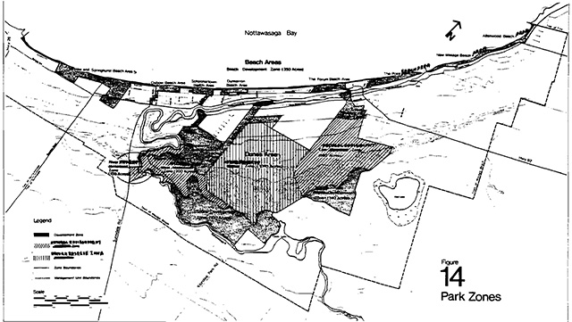
Wasaga Beach Provincial Park will be divided into two major areas which will administratively operate as one park but which functionally will represent distinctly different zones and activities.
The Beach Area of the Park is comprised of nine units totalling approximately 350 acres and linked by 9.1 miles of fine sandy beaches and the waters of Nottawasaga Bay. This part is designed to be an intensively used recreation park, developed to complement existing commercial and residential aspects of the resort town.
The Park also encompasses a large portion of a Provincially significant natural system which has highly fragile geomorphological and botanical components. It is the responsibility of the Ministry of Natural Resources, through the Park, to maintain and preserve representative portions of this system and its components for future generations.
This park section, referred to as the Dunes Area, is comprised of some 2950 acres and will be designed to provide for passive and space requiring recreational uses while still providing varying degrees of protection for the natural environment.
Historic sites and themes of Wasaga Beach range from local to provincial significance. Such themes will be developed and interpreted in conjunction with both the Beach and Dunes Areas of the Park.
In addition, three strategically located “Park Links” will be developed as new or improved locations for pedestrian crossing of the Nottawasaga River between the Beach and Dunes Areas and the community areas adjacent to the park.
5.3 objectives for the park
- To maintain and further develop the beach for traditional. beach day use (swimming and sun bathing) for the people of Southern Ontario.
All of the beach front below high water level, along the town of Wasaga Beach and the areas extending south of the beach front (a total of 350 acres) has been identified as the Beach Area of the park. Cars, once crowding the beach, and driving up and down its length, have been removed. The beach is meant to accommodate people not vehicles. Parking is being provided in the park extensions. This will accommodate most normal use, but peak weekends in the summer will flood our parking facilities. Off-beach parking areas are being considered to accommodate this “peak day” parking. These will be especially successful if town transit systems are developed in the future. The beach area extensions will also hold basic beach use facilities such as garbage, washroom and change house facilities, and scattered picnicking areas. - To create a wider variety of beach front oriented uses for day visitors, tourist cottagers and residents.
The 9.1 miles of beach is not a homogenous unit. Some portions are near a commercial core, others surrounded by permanent dwellings or cottages, family groups or senior citizens. Each section of beach will be developed according to its adjacent community function, and its present and potential users. Creative playgrounds will exist to serve family cottagers as well as family day users. Youths may meet in a special forum. Quiet areas for sitting and viewing, open areas for field sports, tennis, shuffleboard, lawn bowling and volley ball all may occur, in conjunction with different beach areas. - To provide the opportunity for extensive and space requiring recreation activities, in the “Dunes Area”, in recognition of the natural significance a fragility of the area.
Opportunities for hiking, nature study, cross-country skiing or other extensive and space requiring uses are limited in the beach area of the park, because of the small size of the individual park areas along the beach, and the existing and potential density of people and facilities in these areas. The Dunes Area of the park however offers opportunity for such activities, with its larger spaces, lack of existing development, pleasant atmosphere and natural significance. - To preserve a portion of a provincially significant natural system.
Resource evaluation has identified that the Wasaga Beach geomorphological system and its biological components, are provincially significant. They are also very fragile. A representative section will be identified and protected as a Natural Zone in the Dunes Area of the park. - To interpret to the public the various resources of, and stories of, Wasaga Beach, especially as they are illustrated within the park areas.
Wasaga Beach has a varied and interesting history, and a significant natural history. Opportunities will be made available for anyone who is interested to learn about the stories of Wasaga Beach and to explore them to whatever level of detail he desires. - To provide opportunities for education groups at all levels to utilize the natural resources of Wasaga Beach Provincial Park for learning experiences.
Schools are involved in out-of-class education at three levels. Some are offering opportunities for physical expansion (recreation skills); some are involved in general environmental education; and some are going out of the classroom to explore resources that relate to specific topics on their curriculum (history, geology, biology, etc.). Wasaga offers opportunity for all three aspects of out-of class education, for groups from kindergarten through university. The park will provide facilities to encourage these users. - To provide opportunities for further scientific research of the natural system of the Wasaga Beach area.
There is still much to know about the Wasaga Beach area and its resources. Both undergraduate and post graduate (university) students have carried out studies in the past at Wasaga Beach, on the dunes, biology, community development, and so on, that have added new knowledge and have given answers on resource management. Such research will be encouraged to continue. - To attract tourists and day visitors to the Wasaga Beach community, help sustain their interest possibly prolonging their visit, or encouraging their return.
The variety of facilities and services available in the Beach and Dune Areas of the park will help attract day visitors and tourists, and encourage them to stay. Programmed activities (playgrounds, group sports, etc.) and special events sponsored by the park should also add to the attractivity of the recreation community. - To expand the seasons of use of the Wasaga Beach community changing the “peak weekends in summer” to a year-round recreation community.
Park facilities will be developed for year-round use. Activities and special events will be designed to encourage use other than in the summer months. Such activities as “fall colour trips”, cross-country ski meets, fishing derbies, canoe races and so on, run by the park, or with the Town, will help draw tourists and day visitors to Wasaga throughout the year.
5.4 Development philosophy
Wasaga Beach Provincial Park, as a part of the Recreation Community, must contribute a major part of the recreation dimension to the Town. The park will provide a recreation attraction for tourists and visitors as well as resource for the resident, both seasonal and permanent.
Facilities, activities, events, and opportunities will exist to make this a year-round park, to be used in all four seasons of the year.
Wasaga Beach Provincial Park will be unlike most other provincial parks in the sense that its two main sections will be developed so divergently as to almost result in two parks under one name. The administrative, operational and policy aspects of this situation increase significantly over a “single character” type of park; however, the amount and diversity of recreation opportunities increases greatly as well, adding to the attractivity of the park (and hence the Town) for a variety of groups over all seasons.
The concept of a Recreation Community (the existence of a viable provincial park within a town), will take time to be fully understood, and the relationship between town and park will be one that is continually developing through the years.
Town planning and park planning have been moving forward together, so that the Town’s Official Plan and the park’s master plan reflect each other’s direction. The park plan, normally subjected to a five year review process, will be staged so as to coincide with future Town Official Plan reviews.
Park areas will be developed according to the concepts in this master plan. The basic road systems, parking services and support facilities will be established early. However, the areas will not be completely developed until the character of the adjacent town areas is confirmed and the recreation demands on the areas develop through time. Even then, if the Town areas adjacent were to change, and hence a park area to require changing, this can and will be done, as the areas are designed to be flexible.
The Beach Section will handle Wasaga’s traditional intensive recreational pursuits and will complement the neighbouring residential and commercial aspects of the community by providing stability-oriented recreation activities. Further, the provision of facilities, the maintenance of roads and parking lots year-round, and the staging of special events or activities will encourage year-round intensive use.
The Dunes Section will provide for extensive and space requiring recreational uses while providing considerable protection for the natural resources, as the Ministry of Natural Resources has identified “the dunes” as an extremely fragile and significant area. This must be strongly considered as careless planning might result in widespread destruction of the landscape.
5.5 The park identity
An integral and essential aspect of Wasaga Beach Provincial Park will be the implementation of a comprehensive identity programme to identify and provide continuity to the park areas spread throughout the Town.
This programme will entail a coordinated architectural theme for all new park buildings and for renovated and improved existing buildings. Graphic applications on buildings, outdoor interpretive media systems, and a complete, comprehensive signage network for all park sections are essential elements to be incorporated.
A programme of this nature is of paramount importance because of the complexity of the park itself and its rather unique location and environment. The identification system must satisfy two dissimilar park areas which will be designed and intended for very unlike uses. At the same time, the park and its sub-units should relate as strongly as possible in character and identity to the local community. A future consideration may be to integrate signage and graphic systems to firmly establish the Recreation Community concept.
Park logo and sign system
The removal of cars from the beach, changing land uses, development and the complex nature of the provincial park at Wasaga Beach has led to the establishment of visual identity systems to locate and correlate park units. A logo was designed for the park in 1973 and has since been applied in blue colours to signs on the beach and incorporated into supergraphics on park buildings. Elements of flying gulls, rolling dunes, crashing waves, on background colours of water and sand, can all be interpreted from the flowing lines of the Park Logo and its Beach and Dunes variations. This system will be expanded in the future to incorporate the Dunes Area (in brown shades), to provide improved sign structures and to incorporate symbol signs.
Architecture
The repetition of form, colour and materials will ensure a unified visual identity for park buildings, shelters and park furniture. This “theme” will reinforce the repetitive pattern of the logo and signage to clearly identify park structures from the surrounding community buildings.
Because of the difference in environments and in the uses and users, separate architectural themes will represent the Beach and the Dunes.
The Beach Areas will reflect further the colours, and seagull shapes, of the logo.
The Dunes Area structures will be subdued, utilizing more natural materials and colours, and fitting more closely into their natural surroundings.
5.6 Park classification and zoning
The location of Wasaga Beach Provincial Park within a recreation oriented community, the stress on beach front activities and relatively dense park user populations and the emphasis on a variety of year-round intensive recreation activities all identify that this park should fit into the “Recreation Park ”classification.
This conclusion is based on “Administrative Policies of the Ontario Provincial Parks System, 1975”, which identifies five classes of parks:
- Recreation Parks
- Natural Environment Parks
- Nature Reserves
- Wilderness Areas
- Provincial Waterways
Of all parks, recreation parks are most oriented toward provision of a variety of more intensive year round recreation opportunities. There number and distribution is directly related to recreation needs (and opportunities) rather than conservation of historical or natural features.
Natural Environment parks stress recreation activities based upon their outstanding natural and cultural features, and extensive recreational activities of a non-social nature.
Nature Reserves are not intended for mass recreational use. They offer limited re-creative leisure time pursuits associated with enjoyment of their natural features.
The Dunes Area, if located away from the community of Wasaga Beach (or similar complex) would probably be classified as a Nature Reserve, or a Natural Environment Park.
Therefore, in order not to deny the Dunes Area its value, and associated protection, the following will be the classification approach to Wasaga Beach Provincial Park:
Resource identification and evaluation has shown, by management units, what level of development is possible in the Park areas at Wasaga Beach.
To determine the park development concepts, and future park management, the whole Park has been zoned into three categories.
- Natural Zone. This is an area of high natural significance and fragility. Development will be limited to trails for interpretive, educational and scientific purposes.
- Natural Environment Zone. These areas, generally fragile, allow light development, such as recreation and interpretive trails. Landscape modifications will be kept to a minimum.
- Development Zone. Either because the land is capable, or because natural values have been discounted by past use or future need, these areas will continue those uses that require major landscape modification, or contribute very heavy pressures.
6. Park development
6.1 The beach areas
The eight beach areas are all designated as a Development Zone. They will provide basic conveniences found in most day-use parks in the Province, as well as a series of features oriented to extending the park season into spring, fall and winter, with attractions for residents, cottagers and tourists.
A range of development intensities and recreational opportunities will exist along the 9.1 miles of beach, compatible with a variety of user groups and with the adjacent community emphasis and direction.
New Wasaga Beach area and Allenwood Beach area
Flos Beach is divided into two sections by a stream between Mary and Milton Streets. The east section (Allenwood Beach area) and the west section (New Wasaga Beach)will both share the same development strategy.
The park will regulate traffic by controlling vehicular entry onto the beach access road. This access road and a total of 250 car parking sites (125 at Allenwood, 125 at New Wasaga), will confine vehicles to the very back portion of the beach. The intention is to provide only the most basic of services, namely washrooms, allowing this beach to maintain its character as a low-use swimming and sun bathing beach. The easterly section (past the 11th Concession Road)will allow no vehicles, being only a walk-in section.
Many cottagers require beach front access to reach their cottages, and these will be allowed free access through control gates. However, they will be expected to provide their own parking on their own property, with park-built lots intended for those who pay a fee for beach access. This access to cottages via the beach access road will be permitted only during the summer season, i.e. May 1 through October.
The Point Beach area and the Forum Beach Area
These two areas will provide facilities which represent concentrated attention to the day-users and tourists who find the Main Street Mall amusement area the most attractive. These sections will accommodate large numbers of cars and people, and picnic and play areas will be numerous. The lineal aspect of the beach between 12th Street and the Point will be highlighted by a boardwalk which will be designed to facilitate pedestrian movement and access to new and existing features along its length . Other feature activities related to these park sections will include river-oriented recreation, boat launching, and information and interpretive areas. Special community or town-sponsored events can take place in these areas in all seasons.
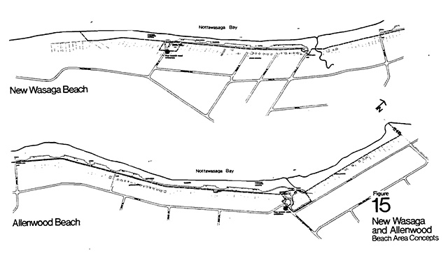
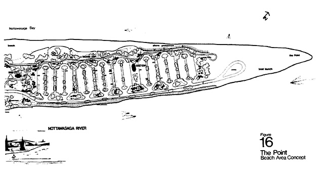
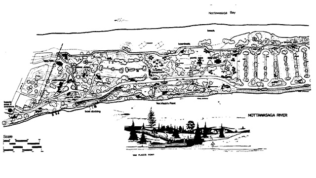
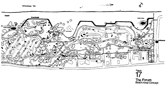
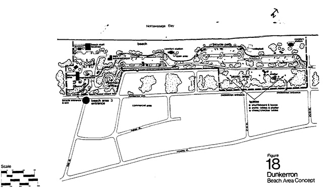
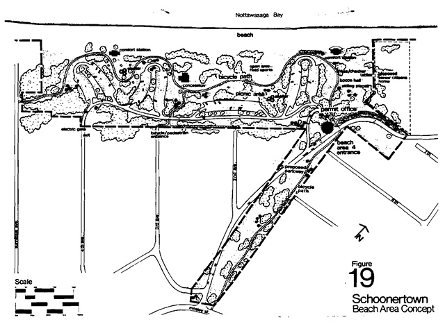
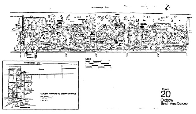
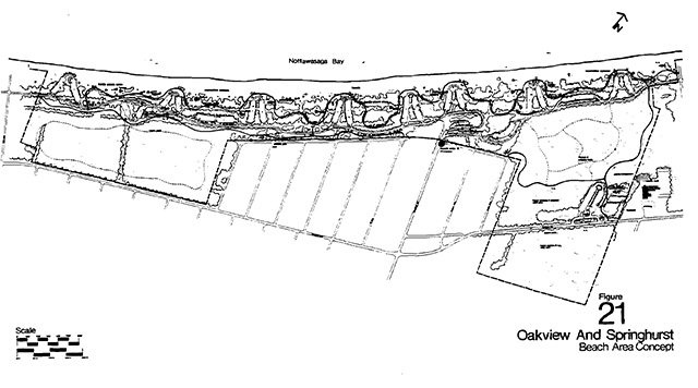
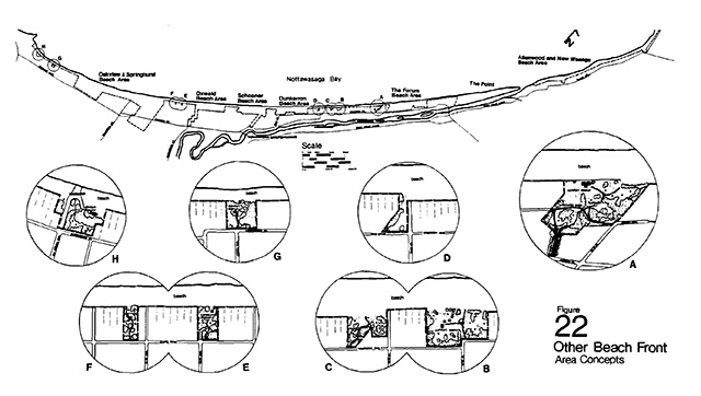
Dunkerron Beach Area
The west end of this area will accommodate the main administrative facilities of the park. The remainder will utilize landscaping and design standards consistent with the other beach areas, but will be intended specifically to accommodate walk-in and bicycle use from the adjacent commercial area, as well as family car parking, picnicking and swimming.
Schoonertown Beach Area and Oxbow Beach Area
These beach areas will be intensively developed for recreation, with their orientation more towards the long-term visitor. This includes permanent and seasonal residents, cottage renters and families camping in the vicinity. Their attraction will also be to groups wanting a “quieter, less commercial” type of recreation.
The two areas will be designed to attract family groups and, as much as possible, people on foot or on bicycle. Play areas will be for all age groups, but special attention will be paid to children and senior citizens. Interpretive media and recreation programmes will encourage repeat visitation and in some instances park facilities developed for all types of day visitors will have additional extended use by the community during summer evenings and in the off-seasons.
Oakview Beach Area and Springhurst Beach Area
The boundaries shown for this concept are boundaries proposed to be completed by 1984. Portions of this concept will be developed as property is acquired.
Development plans for the area designate these two areas as an important western terminus of the park, probably rivalling The Point and Forum Areas in terms of numbers on peak weekends. Provisions are made for family groups of day visitors and cottagers. Special emphasis is placed on the property immediately adjacent to the Oakview Community Centre. This will provide additional activities, facilities and parking for year-round use of the community as well as for the Town and park visitor. Informal court sports, multi-use courts, and an outdoor skating rink are the main features of this area. Artificial ice will help create a long skating season. (Natural ice rinks may be located in other park areas.) Ross Woods will provide opportunity for nature and walking trails, offering the beach user a quiet balance to normal day-use activities.
Other Beach Properties (see Figure 22)
Property acquisition, which began before this plan under earlier direction, has resulted in Crown ownership of parcels of land along the beach front, but outside the major beach area boundaries. These will provide basic services along the beach, we well as pedestrian and bicycle access to the beach. They will provide no parking, and hence may become most used by residents and cottagers as small community “parkettes”.
The most westerly such property will provide a boat launch facility for loca1 residents and cottagers. It will not provide parking and hence will not become an area heavily used by the visiting public. The intention is that a local resident could drive his car to this spot, drop off his boat, and return his car to his house or cottage. It meets a demand expressed by many west end people who have had trouble launching their boats since cars have been removed from the beach.
6.2 The dunes area
Zoning has identified where potential for heavy development lies in the Dunes area, but heavy development here implies much less impact with fewer numbers of people than in the Beach Area. Large portions of the Dunes Area are also identified as having little or no development potential. It is obvious that recreation uses of the Dunes Area are of a much more extensive nature than in the Beach Area. Activities include camping, and a variety of trail uses such as hiking, cycling, snowmobiling, cross-country skiing and snowshoeing. River use, fishing and canoeing, will be encouraged with facilities and events. Educational and interpretive programmes have excellent possibilities in the Dunes Area, which is also the focus for scientific studies.
A genera1 philosophy of Dunes Area development will focus on the preservation of the visual landscape of the whole area with design and landscaping carried out to recreate what is altered in the development of intensive use areas.
To this end, motorcycles, trail-bikes, dune buggies, and other all-terrain vehicles, will be restricted from the Dunes Area on a year-round basis. Snowmobiles will be the exception to this restriction, and will be restricted to operation on specified trails within the Dunes Area, with a further restriction of a minimum snow depth. Scars made by the unrestricted use of such vehicles could result in major visible damage and eventual sand movements.
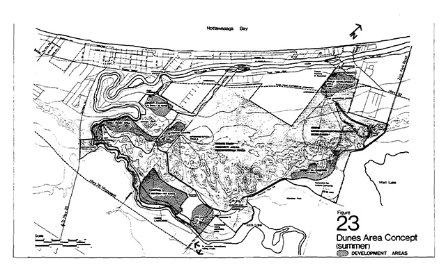
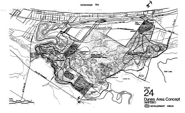
Zoning and development (figures 14, 22)
The natural zone
This zone includes a representative cross-section of the geomorphological system at Wasaga Beach, and also includes some of the more significant of the biological communities. It will be used primarily for scientific research, education and interpretive purposes, with use restricted to designated trails. Such trails may need relocation at regular intervals to avoid a destructive impact on the ground cover. Methods of trail surfacing will be investigated as alternatives to relocation.
Biologists suggest that fire may have been instrumental in maintaining the wide variety of plant communities. Research is currently being carried out to support or disprove this theory. If it is correct, then fire may be used as a management tool in this zone to maintain elements of prairie, prairie heath and savannah.
Existing scars from dune buggies, old logging roads and from blowouts will be rehabilitated. Two plantations will be thinned to leave only native species in a more natural distribution.
The east natural environment zone
Trails will be the main feature of this zone. Hiking, cross-country skiing and snowshoeing will be emphasized.
Interpretation is also a function of the zone with many of the trails serving this end as well as a recreational one.
Special events, especially trails-related, could take place here. Bird walks, botanical trips, educational trips or even international cross-country ski meets are possibilities.
Trail orientation (a warming, waxing and changing shelter in the winter) will be located at the north end of this zone, with parking facilities in the adjacent development zone.
For the non-energetic, the incapable, or the person in a hurry, a loop transit system (tractor train) will be located in this zone, although such location would require extreme care and caution to avoid potential damage to fragile slopes. Its purpose will be to provide an interpretive trip through representative geomorphological and biological sections. The road bed required for this system will also be used as a bicycle trail through this interesting area and connecting to a bicycle link in the south.
West natural environment zone
Fragile and significant, this zone lies between two Development Zones. It has capability for trails, but will need to provide some more intensive facilities, especially road sections. All such development, however, will be carefully designed to minimize visual impact or potentia1 landscape changes. It wi1l also provide for some snowmobile trails linking the development zones. These too will be carefully designed and located.
Walking and hiking trails, and interpretation highlights will be developed in this zone.
The river natural environment zone
River access for fishing, associated support facilities, trails and interpretive features will constitute the development of this zone.
The foredunes development zone
Portions of this zone have been subjected in the past to severe modifications. others are still relatively undisturbed. Generally fragile, it will require a great deal of landscaping with development.
This zone will contain the central sewage system for the Town of Wasaga Beach which will require about 43 acres on the river’s edge. It will also contain portions of the Dunes Area road system with the appropriate entrance facilities. A Visitor Centre concentrating on interpretation of the natural systems of Wasaga Beach and offering out-of-class educational facilities will be built in the eastern part of this zone. Group camping will be located in its northwest section.
Trails may originate here with orientation facilities and a snowmobile take-off point is possible. Parking areas for this type of facility could double in the summer as off-beach parking.
The south development zone
This area will include 300 sites for car camping, of which approximately 100 will have electrical service. These 100 will be maintained for winter camping.
A major entry station will be located on the Powerline Road at the east portion of this section, and nearby will be the administration and maintenance complex. A major snowmobile activity centre (meeting, warming building) will be used in the summer as a horse-riders' assembly area. Horse trails will exist in this section, with connections to out-of-park trails. Snowmobile trails will be located in this section with connections to out-of-park and internal trails. Other features of this zone will be interpretive trails and displays, river access for fishing and canoeing, and bicycle trails.
The east development zone
This zone will accommodate 25 walk-in campsites and associated parking. It may also contain a loop of the tractor train system, connections for an east-west bicycle trail and a snowmobile trail providing access from the east end of town to the snowmobile assembly area in the South Development Zone.
Potential for future car camping expansion exists here and will be considered at the next major plan review.
Nancy island development zone
This zone is defined on the south by the future east-west corridor. Parking for the trails use in the East Natural Environment Zone will be provided here. Off beach parking for peak summer weekends can also be accommodated in this zone.
6.3 Park links
The park links (or bridges), will be those physical features which provide access between the Beach Area and the Dunes Area across the Nottawasaga River. Two bridges are now in existence, and two are proposed. The existing bridge at Main Street was previously the only available means of crossing the river. The Schoonertown Bridge, just completed, will offer a much needed western crossing point and will carry most of the through traffic away from the congested town areas. Both bridges will accommodate cars and pedestrians and would play a vital role when and if a transit system was developed. In addition to these bridges, two additional pedestrian links are proposed.
The first proposed pedestrian bridge would be located in the central part of town, linking the central Dunes Area from the Powerline Road area to the Joan - Bay Streets Commercial Area. This facility would be designed to encourage increased use of the Dunes Area in one direction, and more pedestrian and bicycle traffic to the beach and shopping areas in the other.
The second proposed pedestrian link would span the Nottawasaga River south from Nancy Island. It should attract people away from their cars and away from the Main Street bridge. This link would promote visitation to the Historic Site by providing easier access and more parking on the south side of the river for the museum and for beach use. It should also encourage increased visitation to the Dunes Area. This proposal requires more study on its effect on river traffic and on the use of Nancy Island and will not be developed in the immediate future. It should be given serious consideration at the first major master plan review.
In all cases, the park links are seen as integral keys to the successful development of the two areas of the park and should enhance the character of the community.
6.4 Visitor services
The term Visitor Services refers to the four components of:
- Information
- Interpretation
- Out-of-class Education
- Recreation Programming
Information
Wasaga Beach Provincial Park will be a complex area, with its pieces spread along ten miles of beach and across a river in three links to a large dune area. Different characteristics, varying facilities and services are located in different areas. A visitor can be easily confused.
In order to ensure that visitors and residents understand what the park has to offer, a concentrated information programme will be required. Brochures and maps will explain locations, activities, use requirements, and opportunities to all who need such information. Special features and activities will be identified to help the visitor understand the operation of the park, its functions and opportunities. Such information will be distributed through commercial and government outlets, in park areas, and through the use of mass media.
The Park Information Programme can also deal with joint park-town programmes, and special events.
Interpretation
The natural and cultural history of Wasaga Beach is interesting and important to an understanding of the region and how it developed. These aspects will be interpreted to the visitors to allow them to explore, understand and appreciate the various park themes to the depth which they desire.
Wasaga Beach has several themes for interpretation:
The cultural themes are:
- Prehistoric
- Historic
- Resource Utilization
- Evolution of a resort community
The natural themes are:
- The development of a major geomorphological system
- The biology of the area
Other themes include:
- The management of a recreation resource
- The management of a natural resource
The intention of interpretation is not to place items and artifacts in a museum for people to see, and then forget, but to encourage visitors to explore the resources on site.
To this end, the dunes area will have a major orientation centre, concentrating on natural themes, which will identify the stories of Wasaga Beach and will direct the visitor to individual sites, features and activities related to these stories and themes.
Nancy Island will be managed by the Ministry of Natural Resources as an orientation centre for the historic themes and resources of Wasaga Beach. It will interpret in detail the historical theme associated with the British Schooner Nancy, related events of the War of 1812 and the Nottawasaga River trade and supply route. On site displays, guide-brochures, signs, trails and interpretive staff will help the visitor in his exploration and discovery of this story.
Out-of-class education
There are three aspects to out-of-class education, namely:
- physical recreation skills (learning to snowshoe, camping, etc.)
- general environmental awareness, and
- specified curriculum-related studies.
Wasaga Beach Provincial Park, in the dunes area, can accommodate all three. The park will provide facilities and opportunities for educational groups of all levels, from primary classes through university to develop skills or study the resources of the park. Continuing cooperation with university sponsored research and thesis programmes will help contribute new knowledge of the area.
The out-of-class education facility will be included with the dunes orientation centre, and will provide space for indoor class work and meetings, a library, collections and information, laboratories and basic orientation (shared with the public orientation function.) This will not be a boarding school, but group camping locations will be available for out-of-class education groups. It would be desirable that the commercial community of Wasaga Beach develop accommodation for such groups, perhaps by supplying special group rate structures for overnight accommodation.
Recreation programming
The notion of recreation is relatively new to society and even more novel to provincial parks. In the past, work was the mainstay of existence and recreation alternatives were few. But recently, with the increase in leisure time, mobility, personal income and recreation technology, more of us are not only being made aware of the possibilities available, but now are able to participate. In response to this new recreational demand, professionals, theories and programmes are evolving. This is all manifested at Wasaga Beach.
Play areas, facilities, programmed activities and special events will be provided to the wide array of visitors.
A creative playground in the Oxbow Beach Area, the first of its kind in a provincial park, will provide excitement and challenge to the children while adults enjoy volleyball and badminton and senior citizens play chess and shuffleboard. Volunteers will be encouraged to aid in the programmes. Recreation Programmes will provide activities, fun and enjoyment for all visitors.
Although many programmed recreation activities will occur in the park, the intent of the Recreation Programme is that the community of Wasaga Beach become as intensely involved as possible. Park staff have and will continue to work with the Recreation Board, Senior Citizens, the school and staff of the Town of Wasaga Beach in combined and town-sponsored programmes.
Wasaga Beach Provincial Park, as an integral component of the recreation available for Southern Ontario, will have an important function in responding to the needs of the public by virtue of the recreational services, programmes, facilities and activities available in the park areas.
It is obvious from the foregoing description of the components of the Visitor Services programme that these will be a large commitment to staff to make the programme functional. It is expected that five-year-round staff and ten seasonal (short term) will be adequate to fill the requirements.
Wasaga Beach Provincial Park will have one of the major Visitor Services programmes in the Huronia District. The park will also be expected to act as a “node” for the provision of expertise and programming to other district parks that do not have the resources or need to develop major programmes, but which can still benefit from minor programmes and Visitor Services assistance on general operations problems.
6.5 Activity-facility allocations
| Area | Car parking spaces | Buildings | Other structures | Other facilities |
|---|---|---|---|---|
|
Allenwood Beach Area |
150 |
1 permit-control 4 small washroom change buildings |
N/A |
Beach |
|
New Wasaga Beach Area |
125 |
1 permit-control 3 small washroom change buildings |
N/A |
Beach |
|
The Point Beach Area |
744 |
1 permit-control office 3 large washroom change buildings 9 family picnic shelters 1 small information building 1 small food cession building (private) |
1 picnic terrace and display area (Van Vlack) docking for 20 boats 8 fishing platforms beachfront boardwalk |
|
|
The Forum Beach Area |
475 |
1 permit-control office 2 large washroom change buildings 1 forum (gathering place-the open air theatre-bandshell facility) 9 family picnic shelters 1 small information building 1 small food cession building (private) |
beachfront boardwalk and footpath |
|
|
Dunkerron Beach Area |
253 |
1 permit-control office 2 large washroom change buildings 3 family picnic shelters – and the main park administration complex |
N/A |
|
|
Schoonertown Beach Area |
258 |
1 permit-control office 2 large washroom change buildings 5 family picnic shelters 1 small food concession ( possible but not likely) |
N/A |
|
|
Oxbow Beach Area |
319 |
1 permit-control office 2 large washroom change buildings 9 family picnic shelters 1 small food concession ( possible but not likely) |
N/A |
1 all-age family, creative play area with play structures from tots to teens, duffer grass courts for badminton and volleyball open area for field and running sport checker tables, benches, shuffleboard and a craft shelter, equipment dispersed-static display treed and open picnic areas beach |
|
Oakville Beach Area - beachfront |
320 |
1 permit-control office 2 large washroom change buildings 5 family picnic shelters 1 small food concession (possible) |
N/A |
|
|
Oakville Beach Area - adjacent to Oakview Centre |
130 |
1 building to house washroom and refrigeration plant for artificial ice rink 1 permit-control office |
|
|
|
Oakville Beach Area - Off beach parking |
700 |
N/A | N/A |
|
|
Springhurst Beach Area |
735 |
3 large washroom change buildings (permit office shared with Oakview) 4 family picnic shelters 1 small food concession building (possible) |
N/A |
|
|
Other Beach – front Areas – A – (14th St.) |
Nil |
1 small washroom change building |
N/A |
|
|
B - (17th St.) |
Nil |
1 small washroom change building |
N/A |
|
|
C (18th St.) |
Nil |
N/A | N/A |
|
|
D – (Joan St.) |
Nil |
N/A | N/A |
|
|
E – (13th Ave.) |
Nil |
1 small washroom change building |
N/A |
|
|
F – (14th Ave.) |
Nil |
N/A | N/A |
|
|
G - |
Nil |
1 small washroom change building |
N/A |
|
|
H - |
Nil |
1 small washroom change building |
boat launch area for west and cottagers and residents |
|
|
Off beach parking near zoo property |
1000 |
Possibly a permit-control office |
N/A |
Possible transit pickup area |
|
Nancy Island |
50 |
existing building complex to remain |
No anticipated change |
N/A |
| Dunes Area | Car parking spaces | Buildings | Other structures | Other facilities |
|---|---|---|---|---|
|
Nancy Island development zone |
125 |
1 trail orientation centre |
Future under pass under East-West corridor |
|
|
East development zone |
30 |
2 sets vault toilets |
N/A |
|
|
South development zone |
230 |
1 snowmobile-horseback riding 1 campground entrance office 6 small washrooms with showers 1 park entry permit office 1 small administrative office 1 maintenance shed |
N/A |
|
|
Foredunes concept zone |
150 |
1 major visitor centre 1 park entry-permit office 5 small washrooms for group camping area |
1 footbridge trails across Nottawasaga River to Joan St. area Schoonertown display and parkette area |
|
|
River & West Natural Environment Zones |
80 |
2 small washrooms |
Interpretive display area re-geomorphology |
|
|
River & West Natural Environment Zones |
300 |
2 small washrooms |
Interpretive display area re-geomorphology |
|
|
East Natural Environment Zone |
Nil |
Possible ski trail wind and rest shelters |
N/A |
|
|
Nature Reserve Zone |
Nil |
N/A | N/A |
|
|
Schoonertown Bridge Parkette |
10 |
Nil |
Interpretive Display, benches, boardwalk |
|
7. Planning considerations
7.1 Circulation
The Beach Areas and the Dunes Area are planned to accommodate car traffic and support facilities, assuming that private automobiles will remain the primary method of reaching Wasaga Beach and of moving from Area to Area within the Town and Park. However, park road systems have also been designed to accommodate buses, in case a Town transit system develops in the near future.
Before 1973, the each was cluttered with cars, and any beach experience included vehicles. Part of the philosophy of park development has been to dissociate people from vehicles, and to stress recreation space and activities. To this end, the parking has been limited to less than 25% of the beach area. This means that less than 5,000 parking spaces will be available in the beach areas, of over 11,000 parking spaces required on a peak weekend day (as predicted by Progress Report 1971).
Hence, other parking areas will be developed as the need arises. These parking lots will be intended only to hold the expected multitudes of weekend cars, with connections with trails (both foot and cycle) or transit system to give easy access to the different park areas. Suggested areas include: a property near the Wasaga Beach Zoo; the raised beaches section near Nancy Island; the Beach Area near the Oakview Community Centre, on both sides of Mosely Street; and Management Units 5a, 5b, and 8.
In keeping with the above, this Ministry would encourage the Town to develop community transit systems, primarily during the peak summer season, to take some of the vehicular pressure from busy spots of the Town and Beach. In addition to a system along the whole of the beach, using town and park area roads, a system could also run along River Road West, Klondike Park Road and through the Dunes Area on the park road to the Schoonertown area, to service the community residential areas, the park, and off-beach parking areas.
A park run transit system (namely a tractor train or similar small system) will operate in the East Natural Environment Zone of the Dunes Area but this will be more of an interpretive device than a transit system for destination travel. The future, however, could consider beach transit systems run by the park to give users the capacity to visit many areas without using their vehicles.
Park users will be encouraged through park media and the provision of facilities (bike paths, bike racks, foot paths, boardwalks) to leave their vehicles in one location and visit different features of the Park and Town by foot or bicycle or (if it develops) by a Town transit system. Residents, tourists, cottagers and campers will have excellent opportunities to travel without using a personal automobile through provision of such facilities. We fully expect the private operator to offer adequate rental bicycles to make this an attractive and convenient way to travel through Wasaga Beach for the day users and tourists. Park users will probably respond as well by bringing their bicycles with them.
In keeping with other Provincial Parks, such road improvements and changes would be approached through this Ministry by Park Access Road agreements.
Roads
Progress Report 1971 identified some areas where traffic systems could be improved to aid Town traffic patterns. The Preliminary Master Plan (1974) for the Provincial Park identified areas where road changes would benefit both the Park and the Town. Major changes are suggested in the Dunkerron Beach Area, the Schoonertown Beach Area, the Oxbow Beach Area, and in relation to the Powerline and Golf Course Roads.
Figure Number 18 shows two new north/south sections joining Pine Drive to Dunkerron Avenue to ensure that landowners along the south side of Pine Drive, adjacent to the Dunkerron Beach Area, have continuous uninterrupted access to their properties.
Further, Figures 18 and 19 illustrate an extension of Dunkerron westward past Bay Street through Norman Avenue to First Avenue. This creates an alternative traffic flow to Mosely Street, alleviating some congestion problems, and, as well, provides a smooth link between the Dunkerron and Schoonertown Beach Areas.
Oxbow beach area
Figure 20, the Oxbow Beach Area Concept, shows a major parkway leading from the junction of Sunnidale Road and Mosely Street into the Park Area. This parkway will provide vehicle, foot and bicycle routes to this area.
Powerline Road and the Golf Course Road
As previously mentioned, the plan suggests closure of Powerline Road and its use, in past, as an internal Park road. Traffic normally using this route would find as convenient access via Sunnidale Road and the Schoonertown Bridge, or via the Klondike Park Golf Course Road and the East-West Corridor, or River Road West. To this end the plan recommends the upgrading of the Klondike Park-Golf Course Road to a “County Road” standard, with realignments for safety and protection of the park environment as indicated on Figure 23.
7.2 Activities
Camping
The Dunes Area will provide some camping in selected areas which can support this type of activity. Car camping will be provided in the south development zone, as indicated on Figure 23, providing a total of 300 sites. Initially one hundred of these will be provided with electrical hookups. Washrooms with showers will be provided. The emphasis of the camping, however, will be on the environment, with sites spaced between two and three per acre. Camping will .be expected to stretch into spring and fall seasons at Wasaga Beach, probably the most pleasant seasons for camping due to the excessive heat in the summer.
The one hundred electrical sites will be maintained for winter camping. Demand may increase this number, and such an increase should be considered on plan review.
If excessive demand for summer camping develops in this area, plan review will consider the East Development Zone as a location for another car campground, but this plan does not anticipate that need for at least ten years.
Walk-in camping will be provided (25 sites)in the East Development Zone, with basic facilities only provided. These walk-in sites may be used all seasons. Winter demand is expected from the hardy backpacker and cross country ski camper, who will relate directly to the trails in the East Natural Environment Zone adjacent.
Group camping will be provided for educational groups in the Foredunes Development Zone. This area will accommodate five groups, or a total of 250 persons.
Snowmobiling
Snowmobiling will be encouraged in the west portion of the Dunes Area through the provision of fifteen miles of marked and groomed trails. Snowmobile trails will enter the park at the main entrance in the Foredunes Development Zone, along the north section of the Powerline Road, and from the east via a link trail along the park boundary, utilizing park lands where practical, and portions of the Klondike Park-Golf Course Road allowance (Figure 24).
A major assembly area and facility will be provided in the southeast section of the South Development Zone adjacent to Klondike Park Road. This will provide a warming area and orientation centre for snowmobilers arriving by machine or car and trailer. Internal trails and external trails will link to this centre. The building will have the ability to host meetings and will be available to local groups and clubs for this purpose. A field area for testing and warming up machines prior to trail use will be located adjacent to this centre. It has potential for group activities and special events.
Local snowmobile clubs, who have had major involvement in trail location, maintenance and patrol in the past, will be invited to continue their active participation in the provision of park trails.
Snowmobile trails will be laid out with due consideration of the fragile slopes, and in-park snowmobiling will be limited to a snow cover of over six inches.
Snowmobiling will also be allowed along the beach front(although not within all of the Beach Areas)as long as acceptable to the community.
Other all-terrain vehicles
Because of the major impact that trail bikes, dune buggies, 4-wheel drive vehicles and other all-terrain vehicles have on the unconsolidated sands, these machines will not be accommodated within Wasaga Beach Provincial Park.
Horseback riding
External equestrian trails may link up to the snowmobile assembly area in the South Development Zone, in which case this area will have summer use as an equestrian assembly area. The field adjacent to the assembly centre will provide paddocks and horse trial areas. The South Development Zone will have a minor equestrian trail which will not get into the dunes areas, as the hot temperatures and loose soils are not conducive to horseback riding.
Cross-country skiing and snowshoeing
The Dunes Area is ideal for the fast growing activities of cross-country skiing and snowshoeing, because of its weather, snow cover and terrain. Additional areas are being sought actively by cross-country ski clubs. Provision of such an area, with facilities, will bring additional people to Wasaga Beach, for skiing and for special cross-country ski events.
To develop this activity, the park will provide a centre for waxing, warming, trail orientation, and introductory displays to the park and activities of cross-country skiing and snowshoeing. Groomed trails, and trail side shelters will be provided. These trails will be concentrated in the east part of the Dunes Area, away from the concentration of snowmobiles.
7.3 Management items
Concessions
Persons using the beach or the beach front park areas should be able to purchase basic refreshment items such as hot and cold drinks, ice-cream and light snacks. Private enterprise will likely be able to provide such items with locations between park areas, or adjacent park area boundaries. If private enterprise can, and does provide such services the park will not enter into competition through park concessions.
However, where distances to such items are great, and not within convenient walking distance, the park may establish concession facilities within park areas. Such concessions will be tendered to private enterprise or to local service organizations if they are interested.
Rental of bicycles, cross-country skis, snowshoes and the like will probably be provided through private enterprise. The park does not expect to develop concessions for such items.
No grocery or supply concessions will be provided in the campgrounds of the Dunes Area. Campers will be encouraged to visit Wasaga Beach’s commercial establishments for supplies.
Beach patrol
Provincial Park Beach Patrol staff are not lifeguards and are not intended to relieve parents of any responsibility on the beach. The process of providing full lifeguarding on Wasaga Beach would require hundreds of staff. The park will, instead, provide marked beach patrol areas associated with the Beach Area units for peak hours of use. Persons wishing the extra security of having a person trained in swimming and water first aid should seek these areas out. Regular boat patrols will be carried out during peak hours of peak days to aid boaters and swimmers far from shore. The park boundary extends one quarter mile (1/4) into Nottawasaga Bay.
Servicing
Central sewage and water systems, if available, will service most of the facilities in the Beach Area, but not those in the Dunes Area. Here facilities will be designed to operate on wells and septic systems or vault storage systems. Pumping and dumping of septic systems and vaults will only be carried out by approved operators with approved dumping sites.
Fire is always a hazard. The park will be equipped and park staff trained in ground fire and vegetative fire control. Building and structural fires, however, are not within the Ministry’s capability. The park will enter into agreements with municipal firefighting units to protect the park in case of fire, on a cost-per-call basis.
Park garbage collection has been conducted by our own staff or tendered to contractors in the past. Every attempt will be made to tie in with the municipal garbage collection system. However, the techniques and procedures for garbage collection will be determined after current review.
While the park will have its own security force, this will not take the place of the Ontario Provincial Police in any way. Park Conservation Officers and Security Staff will have jurisdiction only within park boundaries. These staff will still call on the OPP for assistance in dangerous, volatile or criminal situations within park boundaries.
Fees
A day-use fee, consistent with other provincial parks, will be assessed for any cars that enter the Beach Areas or the Dunes Area. People on foot or on bicycles will pay no fee. Therefore, residents and cottagers would benefit by not driving to the beach, and tourists would benefit by leaving their vehicles at their place of accommodation. A fee paid will provide access to any of the Beach Areas or the Dunes area for day-use, for the day the permit is issued.
Regular camping fees will apply and will give access to all other park areas for day-use. User fees will be levied on special facilities such as the multiple use court facility at Oakview.
Nancy Island, under the management of the provincial park will have its fee structure changed to conform with the provincial park fee structure.
Boat mooring
Permanent mooring structures, boat houses, boat hoists, and the like will not be permitted along the shoreline of the provincial park. Overnight mooring or leaving of boats pulled up on the sand will be discouraged along the park shoreline because of the obstruction that such dockages will cause to beach maintenance.
Docks and boat launch areas stress day-use only and will not accommodate overnight mooring.
8. Administration, staffing and development
8.1 Administration
The existing park office is located the end of Bay Street, almost centrally located along the beach. The tradition of its location, its being central, and the availability of existing park property here, all determine that the future administration complex will be in this same location.
This main park office will be located across Bay Street on the east side from the existing office, and will house the majority of the permanent staff. This office will also service a minor public information function. The existing park office will be maintained as a seasonal staff office, specifically for gate staff and beach interpretive staff. The existing block flat-roofed shed (called the Barn) will house beach patrol equipment and act as a seasonal office and training area for beach patrol staff. The four bay maintenance shed, west of Bay Street will house grounds grooming equipment and staff, a carpentry-workshop area, and equipment maintenance. (Refer to Fig. 18).
With the development of the Dunes Area, a seasonal administrative facility will be required there as well, to eliminate an excessive amount of travel and transportation of equipment.
This will include a sub-office for campground staff and interpretive staff, and a small maintenance shed for equipment storage and maintenance.
Such buildings should be winterized to be easily used when year round use develops, or in conjunction with specific winter activities or events.
8.2 Peak staff requirements
Year-round staff
| Function | Permanent Staff | Phase Required |
|---|---|---|
|
Administration |
|
|
| Operations |
|
|
| Maintenance |
|
|
| Total | 15 Permanent | N/A |
Seasonal Staff, at the Height of the Summer Season
| Function | Seasonal Staff |
|---|---|
| Administration | 1 Clerk |
| Operations |
1 Beach Patrol Supervisor 22 Beach Patrol Staff 1 Gate Supervisor 20 Gate Attendants 10 Visitor Services Staff 10 Security Officers |
| Maintenance |
30 Beach Maintenance 15 Dunes Maintenance 4 Equipment Operators 1 Electrician 1 Planter |
| Total |
116 Seasonal |
Wasaga Beach provincial park organization chart
- Park Superintendant
- Stenographer
- Assistant Superintendant - Security, Branch Patrol & visitor Services
- Beach Patrol
- Senior Beach Patrol
- Beach Captains
- Beach Patrollers
- Beach Captains
- Senior Beach Patrol
- Security
- Security Supervisor
- Security Officer
- Security Supervisor
- Visitor Services
- Visitor Services Coordinator
- Recreationist
- Historical Programmer
- Naturalist
- Seasonal Programmers
- Media Designer
- Visitor Services Coordinator
- Beach Patrol
- Assistant Superintendant
- Beach Maintenance Foreman
- Head Gate
- Gate Attendant
- Head Gate
- Development Coordinator
- Surveyors
- Development Foreman
- Clerk Stenographer
- Landscaper
- Head Carpenter
- Carpenters
- Designer
- Dunes Maintenance Foreman
- Campground Foreman
- Maintenance Workers
- Trails Foreman
- Maintenance Workers
- Campground Foreman
- Beach Maintenance Foreman
8.3 Phasing
Portions of this plan have already been satisfied by the Ministry of Natural Resources (in the period from 1962 to date) which has been managing the beach and the provincial park, and has been acquiring property.
Future development will take place in three phases. These will be reflected in the priority of future land acquisition.
Phase I
This phase will see the completion of all beach development in the following areas:
It would also include the completion of the main administration facilities for the park.
This phase must also include the provision of parking and basic facilities to support the winter trails programme in the Dunes Area.
Phase II
This phase will concentrate on the Dunes Area and will see completion of the basic concept in terms of facilities and buildings. It will also consider off-beach parking, and will schedule as required the completion of major parking areas in the Oakview Beach Area, adjacent to Oakview Centre, and at the park property adjacent to the Wasaga Beach Zoo.
Phase III
Phase III will complete development of Oakview and Springhurst Beach Areas and will consider pedestrian and bicycle crossings over the Nottawasaga River at Nancy Island and at the foot of the Powerline Road.
Then, except for upgrading of facilities to meet changing recreation patterns, the park development will be complete.
Timing for the different phases is dependent on land acquisition and is difficult to establish. However, a final date of 1986 is suggested as the end of Phase III.
8.4 Costing
Property acquisition is still incomplete at Wasaga Beach Provincial Park. Most immediate priorities include the acquisition of isolated parcels to permit completion of all beach areas except Oakview Beach and to consolidate the nature reserve zone of the Dunes Park area.
The current (1978) park development program at Wasaga Beach will not complete phases II or III as summarized in Section 8.3. It will, however, complete a system of trails with ancillary shelters, toilet facilities and parking in the Dunes area to accommodate hiking, cross-country skiing, and boat launching on the Nottawasaga River. The construction of a campground and major visitor centre not included.
The development of all beach areas will be completed with the exception of Oakview Beach where only limited parking and facilities will be provided.
The following costs are estimated for completing the level of development noted above:
- Land Acquisition - $2,300,000.00
- Park Development - $2,800,000.00
The estimated operating cost for year-round operation is $600,000.00
9. Reference material
Ainley & Assoc. Ltd., Ministry of Treasury, Economics & Inter- governmental Affairs - Surface Water Drainage Report, Wasaga Park Community Project. 1972
Ainley & Assoc. Ltd., Ministry of Treasury, Economics & Inter- governmental Affairs - Wasaga Park Community Project: Summary Report on Soils, Drainage and Land Suitability. 1972
Baines, W. D. University of Toronto. Preliminary Report on Wasaga Beach. 1963
Barker, J. K. University of Waterloo. Wasaga Beach: A Study in Outdoor Recreation. 1968
Bobbette, R. S. W. Ministry of Natural Resources. Flora and Environment of the Wasaga Beach Community and Provincial Park. 1975
Carlisle, R. J., Cuddy, D. G., and Norman, R. Ministry of Natural Resources. Wasaga Beach: An Ecological Assessment. 1972
Carlisle, R. J., Ministry of Natural Resources. Biological Community Fragility Mapping. 1974
Conway, R. A. Ministry of Natural Resources. Archaeological Survey of Wasaga Beach. 1973
Deane, R. E. Geological Survey of Canada Memoir 256. Pleistocene Geology of the Lake Simcoe District, Ontario. 1956
Deleuw Cather & Company of Canada Ltd. Ministry of Transportation & Communications Interim Report: Wasaga Beach Provincial Park, Summary of Traffic Survey. 1967
DeLeuw Cather & Company of Canada Ltd. Ministry of Transportation & Communications Hwy. 26 Feasibility Study: Barrie Bypass to Stayner. 1974
DeMille, S. Ministry of Natural Resources. Historical Significance of Schoonertown and Role of the Naval Establishment in the Provincial Defence System. 1973
Irvine, R. J. Department of Lands and Forests. A Short Term Analysis of Crown Procedures and Activities at Wasaga Beach Provincial Park. 1966
Knopp, T.B. and Tygen, J.D. Journal of Leisure Research. A Study of Conflict in Recreational Land Use: Snowmobiling vs. Ski-Touring. 1973
Martini, I.P. University of Guelph. Study of Sands of Wasaga Beach – Data. 1973
Martini, I.P. University of Guelph. Geomorphology, Land-Use and Conservation of the Quatenary Barrier System of Wasaga Beach, Ontario. 1974
Martini, I.P. Land Use and Geology of Wasaga Beach, Ontario. 1974
Martini, I.P. University of Guelph. Sedimentology of Lacustrine Barrier System at Wasaga Beach, Ontario, Canada. 1974
Martini, I.P. Wasaga Beach: A Quatenary Classic Landscape, Its Geological History, and Biological Carrying Capacity of the Sand Dunes. 1974
McHarg, I.L. Design with Nature. 1969
O'Brien, R.M. Ministry of Natural Resources. Archaeological Survey of Wasaga Beach. 1975
Ostler, J. Ministry of Natural Resources. The Wasaga Dune Field. 1972
Pelshea, V. Ministry of Natural Resources. Archaeological Survey of Wasaga Beach. 1973
Porter, C.J.B.L. Ministry of Natural Resources. An Inventory of the Historical Resources of Wasaga Beach: The Nottawasaga River, A Route to the North-West 1785-1830. 1973
Project Planning Associates Limited. Wasaga Beach Provincial Park: Interim Report No.1. 1965
Project Planning Associates Limited. Wasaga Beach Provincial Park: Phase II, Survey and Analysis. 1957
Project Planning Associates Limited. Wasaga Beach Provincial Park: Phase II, Long Range Goals and Policies. 1967
Project Planning Associates Limited. Wasaga Beach Master Park and Community Plan: Draft Report. 1967
Project Planning Associates Limited. Wasaga Beach Provincial Park, Volume 1. Master Plan and, Volume 2 Survey & Analysis. 1967
Project Planning Associates Limited. Final Draft Wasaga Beach Implementation Plan - Stage 1. 1969
Shrivastava, H. N. Ministry of Natural Resources. The Muck in Wasaga Beach - Georgian Bay. 1971
Shrivastava, H. N. Ministry of Natural Resources. The Detritus Problem at Wasaga Beach. 1973
Taylor, L. T. Ministry of Natural Resources. Flos Beach Report. 1971
van der Meer, J. A., et al. - Ministry of Natural Resources. Wasaga Beach Provincial Park Master Plan. 1974
Wiseman, J. Ministry of Natural Resources. The Birds of Wasaga Beach and Vicinity. 1975
Wolfe, R. University of Toronto. Recreation in Ontario. 1948
Woolsey, G.B. Ministry of Natural Resources. The History of Wasaga Beach: Geography as a Determinate in History. 1972
Department of Municipal Affairs. Wasaga Park Community Project: Reports on Beach-User Survey 1970, Beach-User Statistics, 1970. 1971
Department of Municipal Affairs. Wasaga Park Community Project: Progress Report, 1971. 1972
Ministry of Natural Resources. Preliminary Report on Historic Sites Along the Nottawasaga River at Wasaga Beach. 1974
Ministry of Environment. Water and Sewage Systems, Wasaga Beach Area. 1974
Ministry of Transportation and Communications. Internal Road System, Wasaga Park Community Feasibility Study Report WP 61-70. 1974
Ministry of Treasury, Economics and Inter-governmental Affairs. Share a Challenge: Wasaga Recreation Community. 1974
Ministry of Treasury, Economics and Inter-governmental Affairs. Wasaga Beach Community Project - Highway 92. 1974