Wenebegon River Provincial Park Management Statement
This document provides policy direction for the protection, development and management of Wenebegon River Provincial Park and its resources.
Interim Management Statement
® Ontario 2006
Approval statement
I am pleased to approve this Interim Management Statement for Wenebegon River Provincial Park. Ontario’s Living Legacy Land Use Strategy (1999) identified this area as a waterway class provincial park. This park was regulated under the Provincial Parks Act in June 2003 (O. Reg. 210/03).
This Interim Management Statement provides direction for the protection and management of Wenebegon River Provincial Park.
Signed by:
Paul Bewick
Zone Manager
Northeast Zone
Ontario Parks
Date: December 4, 2006
1.0 Introduction
Wenebegon River Provincial Park (P274) is a 16,383 hectare waterway park.The northern part of the park is approximately 20 kilometres south of Chapleau while the southern portion is approximately 93 kilometres south of Chapleau (Figure 1). Five Mile Lake Provincial Park is adjacent to the western edge on the northern part of Wenebegon River Provincial Park (Figure 2a). The middle section of the site is surrounded by East Wenebegon Conservation Reserve (Figure 2b). The southern tip of the park is adjacent to Aubrey Falls Provincial Park, while both the east and west sides of the southern part of the park is surrounded by two Enhanced Management Areas (EMA) (Figure 2c).
This park was identified through Ontario’s Living Legacy Land Use Strategy (OMNR 1999) and selected to protect outstanding recreational water routes and provide high quality recreational and educational opportunities. The park was regulated on June 7th, 2003 (O. Reg. 210/03).
1.1 Objectives
Wenebegon River Provincial Park will be managed consistent with the four objectives for provincial parks:
Protection: To protect provincially significant elements of the natural and cultural landscapes of Ontario.
Recreation: To provide provincial park outdoor recreation opportunities ranging from highintensity day-use to low-intensity wilderness experiences.
Heritage Appreciation: To provide opportunities for exploration and appreciation of the outdoor natural and cultural heritage of Ontario.
Tourism: To provide Ontario’s residents and out-of-province visitors with opportunities to discover and experience the distinctive regions of the province.
2.0 Management context
The purpose of this Interim Management Statement (IMS) is to provide direction to ensure the custodial management of park resources. Future park planning may be undertaken as required to provide direction on significant decisions regarding resource stewardship, development, operations and permitted uses.
Park management will follow direction from:
- Provincial Parks Act (1990) and regulations
- Ontario Provincial Parks Planning and Management Policies (OMNR 1992)
- Crown Land Use Policy Atlas (OMNR 2004a)
- Ontario’s Living Legacy Land Use Strategy (OMNR 1999) and policy clarifications (OMNR 2000), amendments, and related direction
In addressing custodial management obligations to protect park values and ensure public health and safety, Ontario Parks will ensure that policy and Environmental Assessment Act (1990) requirements are implemented.
Figure 1: Regional Setting
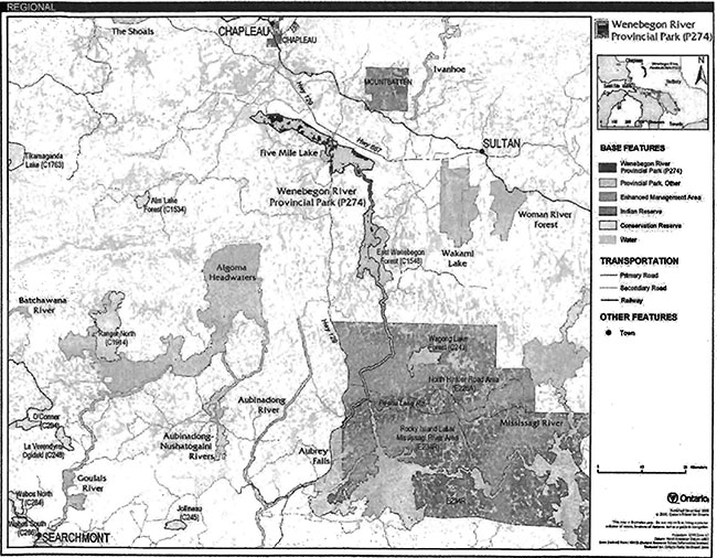
Enlarge Figure 1: Regional Setting (PDF)
Figure 2a: Park Boundary - North
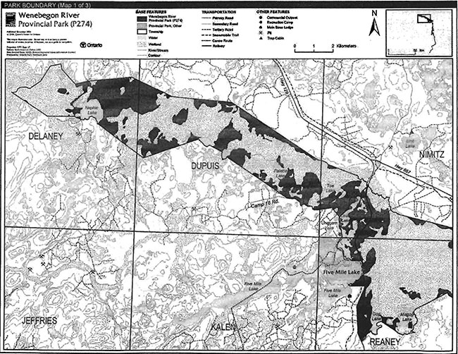
Enlarge Figure 2a: Park Boundary - North (PDF)
Figure 2b: Park Boundary - Central
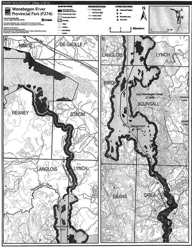
Enlarge Figure 2b: Park Boundary - Central (PDF)
Figure 2c: Park Boundary - Southern
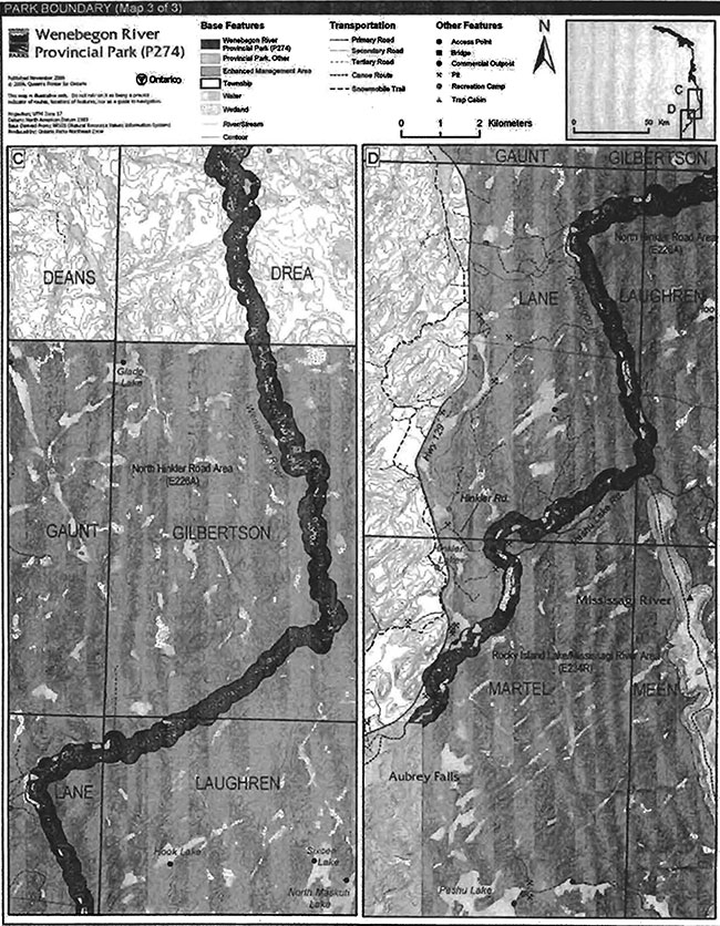
Enlarge Figure 2c: Park Boundary - Southern (PDF)
2.1 Environmental Assessment
As a part of the Ontario Ministry of Natural Resources (MNR), Ontario Parks is a public sector agency which is subject to the Environmental Assessment Act. Park management will be carried out in accordance with legislation, policies and guidelines that are required under A Class Environmental Assessment for Provincial Parks and Conservation Reserves (OMNR 2005).
3.0 Park features and values
Wenebegon River Provincial Park includes a series of unusually large wetlands, often referred to as peatlands, in the northern portion of the site. This pattern of wetlands is very common in the James Bay Lowlands but very uncommon in Ecodistrict 4E-3 (Arnup 1991). The core wetland area was recognized as a candidate Area of Natural and Scientific Interest (ANSI) referred to as the Reaney Township Peatlands, in the early 1990s. Another peatland in Dupuis was subsequently identified. Both are considered provincially significant.
The park includes portions of both the Little Wenebegon River and the Wenebegon River valleys. The Little Wenebegon River flows between the peatland in the north of the park to Lake Wenebegon. The Wen begon River flows into Lake Wenebegon and continues south to Aubrey Falls Provincial Park. The Wenebegon River offers both flat water and white water experiences.
Wenebegon Lake, a south flowing lake, its interior islands and perimeter are also included in the park.
3.1 Geological features
The Precambrian bedrock of the park is Archean granitic and gneissic rock of the Superior Province. The course of the Wenebegon River is strongly influenced by the regional bedrock fracture pattern at the south end of the park. The "dog leg" pattern that has formed, is probably the best example of this type of bedrock influence on physiography and landforms, and consequently, is of provincial significance (Blackburn 2004).
The Wenebegon River meanders through quaternary deposits of glacial outwash at the south end of the park. Oxbow lakes and scars are common and ground moraine covers the central area of the site around Wenebegon Lake. Organic terrain over glacial outwash is found in the northern part of the park. Outwash sand dunes are found near Gog and Magog Lakes while an esker and kame complex is near Unegam Lake. These features are considered to be locally significant (Blackburn 2004).
3.2 Biological features
Wenebegon River Provincial Park extends from the northern extreme of Ecodistrict 4E-3, near Chapleau, southward to Aubrey Falls Provincial Park. The park includes peatlands, a river corridor, and a large lake.
The peatlands in the northern portion of the park developed over glaciolacustrine and glaciofluvial fine sand, which was deposited under the proglacial Lake Sultan. The wind has reworked the deposit prior to the development of the peatlands. Two sections of these peatlands were designated as provincially significant: the Dupuis Township Peatland and Reaney Township Patterned Peatland. The latter is particularly significant for its regionally unique patterning of bog, fen, coniferous swamp, and open pool wetlands (Morris 2003).
Between the peatlands and Wenebegon Lake, the park includes the Little Wenebegon River and a 200 metre terrestrial corridor. Most of the jack pine and spruce forests in this area have been cut-over recently, including much of those within the 200 metre terrestrial corridor. As such, the outer sections of the terrestrial corridor are sparsely vegetated with young trees and pioneer species. Between Wenebegon Lake and Aubrey Falls Provincial Park, the park includes the Wenebegon River and a 200 m terrestrial corridor.This section is dominated by jack pine, coniferous and alder thickets near the river (Morris 2003).
The park also includes Wenebegon Lake as well as a 200 metre wide area around the perimeter. The lake includes several wetland types including fen, hardwood swamp, emergent and aquatic marshes and supports a warm water walleye fishery. The terrestrial perimeter includes part of the East Wenebegon Lake Forest and Lowlands Natural Heritage Area, which is provincially significant because of its high concentration of white cedar dominated forests. Modest-sized stands of old-growth white pine also occur on the east shore of Wenebegon Lake (Morris 2003).
3.3 Cultural setting
An investigation of cultural features specific to Wenebegon River Provincial Park has not been completed.
Any future planning will be within the context of a provincial framework, A Topical Organization of Ontario History (OMNR 1974). In addition, updates and discussions with First Nations, other agencies and stakeholders may be carried out to identify cultural heritage values and features within the park and their significance. This information may be used to develop management guidelines to conserve and protect representative archaeological and historical values and features, or to provide direction for further research.
3.4 Recreation
Wenebegon Lake is a remote tourism destination. There is one existing authorized access point from Hwy 129 to Wenebegon Lake. Recreation activity within the park is largely water-based and includes fishing, canoeing, boating and camping.
The Wenebegon River Canoe Route originates at Chene Lake west of Highway 129. This route follows the Wenebegon River to Wenebegon Lake back to the Wenebegon River again and then to Aubrey Lake, located outside the park.
Unauthorized all-terrain vehicle (ATV) trails have been cleared to access Wenebegon Lake and associated outpost camps.
An authorized snowmobile trail crosses the park in Reaney and Nimitz townships (Harper 2003).
4.0 Aboriginal uses
Consultation on the boundary regulation of Wenebegon River Provincial Park involved the following First Nations in November of 2002: Garden River, Batchewana, Mississauga, Thessalon, Serpent River, North Shore Tribal Council, Brunswick House, Chapleau Cree, Missinabie Cree, Chapleau Ojibwe. No issues were identified specific to the regulation of the boundary of this park (OMNR 2003b).
Located east of Chapleau Cree Indian Reserve, Wenebegon River Provincial Park lies within both the Robinson-Huron Treaty (1850) area and the Robinson-Superior Treaty (1850) area.
First Nations have expressed interest in and have shared knowledge of the park and surrounding area. Aboriginal communities have used the area for hunting, trapping, fishing, gathering and travel. These uses may continue, subject to public safety, conservation and other considerations.
Any communications and cooperation between Aboriginal communities and the MNR for planning and operations purposes will be done without prejudice to any future discussions or negotiations between the government of Ontario and Aboriginal communities.
5.0 Stewardship policies
5.1 Terrestrial ecosystems
Removal, damaging or defacing of Crown property, natural objects, relics and artefacts is not permitted in provincial parks (Provincial Parks Act).
Non-native species will not be deliberately introduced into the park. Where non-native species are already established and threaten park values (i.e., has become invasive), a strategy to control the species may be developed (OMNR 1992).
5.1.1 Vegetation
Harvesting
Commercial forest operations are not permitted within the park (OMNR 1992).
The harvest of non-timber forest products such as club moss, Canada yew, etc., will not be permitted within the park (OMNR 1992).
Existing authorized wild rice harvesting may continue. New operations will not be permitted.
There are no fuelwood cutting permits currently issued for the park. New permits witl not be issued (OMNR 2000).
Insects and disease
Insects and diseases may be managed where the aesthetic, cultural or natural values of the park are threatened (OMNR 1992). Control measures will follow guidelines established by the Ontario Ministry of the Environment (MOE) and MNR. Whenever possible, biological control measures will be given preference over the use of chemicals (OMNR 1992).
Fire
Wenebegon River Provincial Park is located within MNR's Great Lakes-St. Lawrence Fire Management Zone. In accordance with existing provincial park policy and the Forest Fire Management Strategy for Ontario, forest fire protection will be carried out in the park as on surrounding lands (OMNR 2004a).
Whenever feasible, MNR's Forest Fire Management program will use techniques that minimize damage to the landscape, such as limiting the use of heavy equipment or limiting the number of trees felled during response efforts (OMNR 2004b).
5.1.2 Wildlife management
Wenebegon River Provincial Park is located within Wildlife Management Units 35 and 38. The removal or harassment of non-game animals is not permitted (Provincial Parks Act).
Hunting
Sport hunting is permitted to continue. Considerations of safety and conservation with respect to hunting may be made through future management planning, which includes public and Aboriginal consultation (OMNR 2000).
The Fish and Wildlife Conservation Act (1997) and the Migratory Birds Convention Act (1994) govern hunting within the park. The Ontario Hunting Regulations Summary contains regulations specific to this area. The harvest of bullfrogs or snapping turtles is illegal in provincial parks.
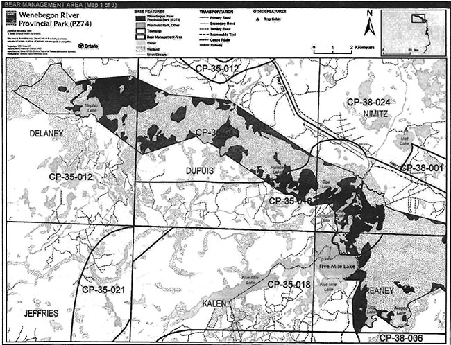
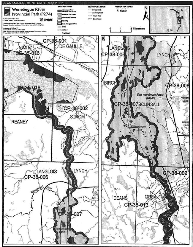
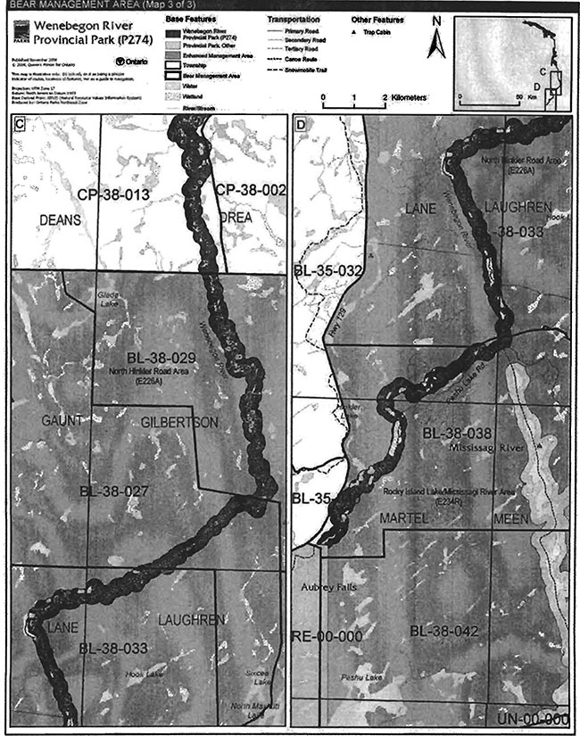
Bear Management Areas
The park includes portions of 13 licensed bear management areas (BMA): CP-35-013, CP-35-012, CP-35-016, CP-35-018, CP-38-002, CP-38-006, CP-38-007,CP-38-013, BL-38-029, BL-38-027, BL-38-033, BL-38-038 and BL-35-040 (Figures 3a, 3b and 3c). Existing commercial bear hunting operations are permitted to continue. This activity may be subject to conditions identified during future management planning (e.g., the designation of nature reserve zones).
New BMA licences will not be permitted (OMNR 2000; 2003a).
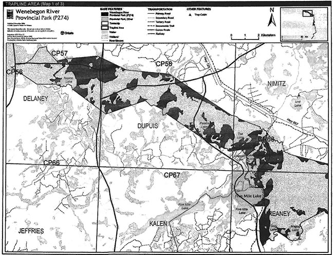
Trapping
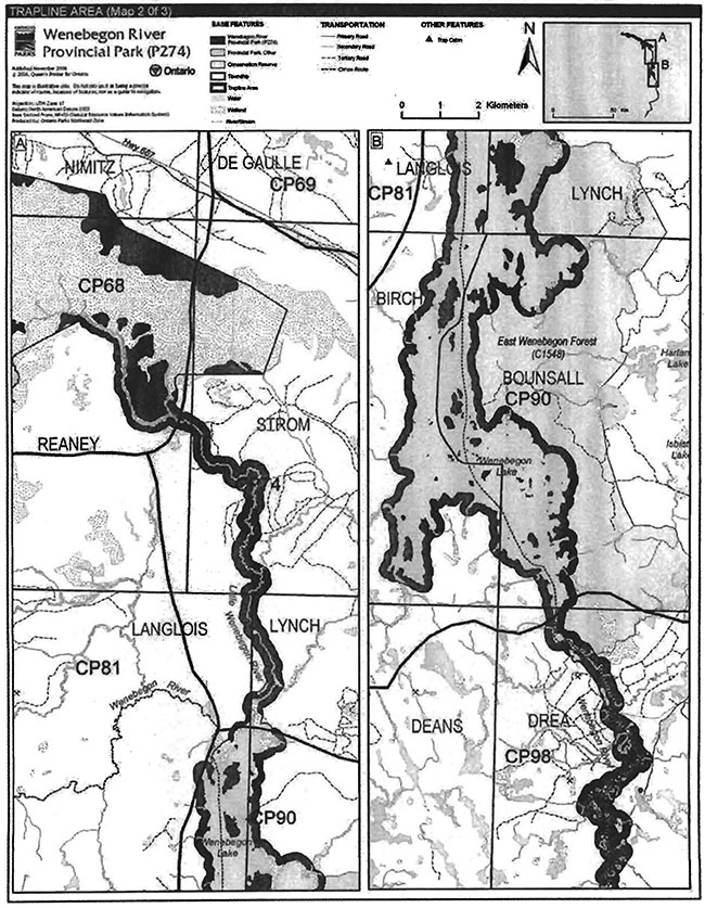
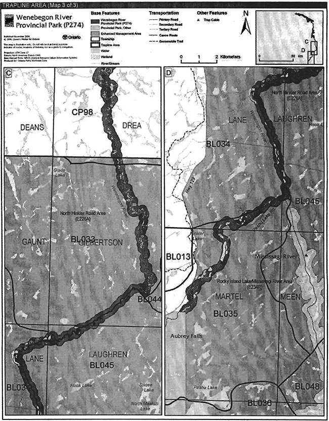
There are portions of 14 licensed trap lines within the park including CP56, CP57, CP58, CP66, CP67, CP68, CP74, CP90, CP81, CP98, BL33, BL34, BL35, BL45, (Figures 4a, 4b and 4c).
Trap line BL-35 and CP-90 each have an existing trap cabin associated with the line in the park. The existing use of the trap cabins will be permitted to continue. New trap cabins and associated trails will not be permitted. The relocation of existing trails and cabins will be subject to ecological principles, management planning and screening through the Class Environmental Assessment for Provincial Parks and Conservation Reserves (OMNR 2000; OMNR 2005).
Existing commercial fur harvesting operations may continue where the activity has been licensed or permitted since January 1, 1992. New operations, including trap cabins and trails, will not be permitted (OMNR 2000; 2003a).
Transfers of active trap line licenses are permitted, subject to a review of potential impacts and the normal transfer or renewal conditions that apply.
5.1.3 Industrial resources
Aggregate extraction is not permitted in provincial parks unless it is allowed by regulation (OMNR 1992; 2004a; Provincial Parks Act 1990).
The Ministry of Transportation (MTO) has identified old aggregate pits that it previously used prior to the regulation of Wenebegon River Provincial Park (Figure 2a and 2c).There are three old pits that are located in the northern portion of the park in Nimitz Township. In addition there is a fourth old pit that is located near Aubrey Falls Provincial Park in Martel Township. Only half of the latter old pit is included within the park (D. Forsyth, personal communication, December 4, 2006).
Aggregate extraction will be permitted in aggregate pits that are licensed under the Aggregate Resources Act prior to the proclamation of the new Provincial Parks and Conservation Reserves Act (2006). As licence limits are worked there will be progressive or sequential restoration of licensed pits to allow sites to return to a natural condition (e.g., slope stabilization, native species plantings).
Figure 3a: Bear Management Areas
Enlarge Figure 3a: Bear Management Areas (PDF)
Figure 3b: Bear Management Areas
Enlarge Figure 3b: Bear Management Areas (PDF)
Figure 3c: Bear Management Areas
Enlarge Figure 3c: Bear Management Areas (PDF)
Figue 4a: Trapline Areas
Enlarge Figue 4a: Trapline Areas (PDF)
Figure 4b: Trapline Areas
Enlarge Figure 4b: Trapline Areas (PDF)
Figure 4c: Trapline Areas
Enlarge Figure 4c: Trapline Areas (PDF)
There are no existing mining claims within the park. The mining and surface rights on all lands within the park have been withdrawn from staking under the Mining Act (1990). Mineral exploration and mining are not permitted in the park.
5.1.4 Access and crossings
Access
Highway 129 runs parallel to and some sections of the highway enter the park. Highway 129 also supports several secondary and tertiary roads (Camp 16 Road and Hinkler Road) that pass into the park. There is no authorized public access to the park from Highway 129.
There is one authorized public access on the Wenebegon River in Lane Township (Figure 2c). The park superintendent may authorize a second public access in Drae Township (Figure 2b). This would allow access from Highway 667 and the Robinson Lake Road to enter the park to launch boats on the river and travel upstream to Wenebegon Lake. Camping and boat caching is not allowed at either access point.
The superintendent will assess access to determine.overall road I trail access needs.
An Ontario Federation of Snowmobile Clubs (OFSC) Trans Ontario Provincial Series (TOPS) trail, Trunk Trail F crosses the park, west of Least and Unegam lakes in Nimitz Township (Figure 2a).
Aircraft can be authorized to land in the park (e.g., Wenebegon Lake).
A canoe route provides access to Wenebegon Lake and the southern portion of the park.
Roads
Highway 129 is located west of Wenebegon River Provincial Park in the southern section of the site. The highway passes through Nimitz and Reaney townships in the northern portion of the site and Martel Township in the south. The highway corridor is excluded from the park boundary.
Camp 16 Road (also referred to as Camp 16 Loop) which is included inside the park boundary provides access to private land parcels on Least Lake and Unegam Lake. This road branches from Highway 129, near the north end of Least Lake. A portion of a secondary road branching north from Camp 16 Road in Delaney Township, crosses the park boundary west of Nephic Lake (Figure 2a). These roads are not authorized for public use to access the park.
Numerous unnamed roads enter the park at various points in Nimitz, Reaney, Strom, and Lane townships. The sections of these roads within the park are not authorized to allow park access.
A forest haul road in Drea Township may provide access to allocations west of the park. A portion of this road is included in the park (Figure 2b). A forest haul road (Hinkler Road) enters the park and crosses the Wenebegon River in Martel Township. A section of this road is included in the park. This road has been identified as a long term haul road by Northshore Forest Incorporated (Figure 2c). These roads are not authorized for public use to access the park.
Where existing forest access roads are essential for continued access beyond the park for forest management or recreation purposes, and alternative road access does not exist, or road relocation is not feasible, existing roads will continue to be available for access. Continued use will include maintenance and may include upgrades (OMNR 2004a).
Ontario Parks is not responsible to maintain or upgrade any roads within the park.
Any proposed development, maintenance or upgrading of existing roads must meet all Environmental Assessment Act requirements.
Utility corridors
There are no utility corridors within the park.
All public utilities (e.g., gas pipelines, transmission lines, communications towers) must avoid park lands wherever possible. New utility corridor crossings may be necessary to maintain essential public services (OMNR 2004a).
Any future utility corridors proposed through the park, where park lands are unavoidable, will be reviewed on a case-by-case basis. Protection of park features and values will be a priority and all requirements of the Environmental Assessment Act will be met.
Recreational trails
All-Terrain Vehicles: One authorized ATV trail may be authorized on the Wenebegon River in Drea Township to allow boat launching. Other unauthorized ATV trails found in the park will be closed. Off-trail ATV use is not permitted.
Canoe Routes: The majority of the Wenebegon River Canoe Route is included in this park. The route begins just west of Highway 129 at Burying Creek. Burying Creek leads to Chene Lake which then leads to the Wenebegon River. The canoe route follows the Wenebegon River west to Wenebegon Lake into the park. The route continues south from Wenebegon Lake into another portion of the Wenebegon River to the end of the canoe route at Aubrey Falls Provincial Park.
Snowmobile: There is an existing snowmobile trail within the park in Reaney and Nimitz townships (Figure 2a). The trail is an Ontario Federation of Snowmobile Clubs (OFSC) Trans Ontario Provincial Series (TOPS) trail. Trunk Trail F. Chapleau Arctic Watershed Snowmobilers Incorporated is the local club in the area that maintains this trail. The snowmobile trail enters the park from the north at Highway 129 and continues south. The trail goes on the west side of Least and Unegam lakes. It leaves the park south of Unegam Lake and continues to follow Highway 129 south. There are no major water crossings on this trail within the park.
Snowmobile use on existing routes for access to private land in-holdings, LUPs, and recreational ice fishing may continue unless park values are threatened.
Other Trails: There are currently no other authorized recreational trails within the park. New trails (e.g., hiking) may be developed if the need arises. Any proposed development within the park is subject to Environmental Assessment Act requirements.
5.1.5 Adjacent land management
Forestry
The land adjacent to the park is within the Superior Forest and the North Shore Forest sustainable forest license areas.
The Superior Forest is currently managed by Tembec Industries Incorporated under license number 508. This area is managed according to the 2006-2026 Forest Management Plan for Superior Forest which includes a five year operations plan (K. Ellis, personal communication, November 17, 2006).
The North Shore Forest is currently managed by Northshore Forest Incorporated under license number 680. This unit is managed according to the 2005-2025 Forest Management Plan for Northshore Forest which includes a five year operations plan (T. Lehman, personal communication, November 17, 2006).
Provincial parks
Aubrey Falls Provincial Park is located at the southern boundary of Wenebegon River Provincial Park. Aubrey Falls was designated as a park in 1985. Park facilities include a hiking trail, scenic outlook, and parking lot.
Mississagi River Park Additions (P238) is located south east of the southern portion of the park. There were 66,734 hectares added to the existing Mississagi River Provincial Park. The additions encompass natural heritage areas and areas that will enhance recreational use within the park.
Conservation Reserves
East Wenebegon Forest (C1548) is located east of Lake Wenebegon. The conservation reserve contains white cedar dominated lowland forests as well as forests dominated by black spruce and tamarack. Upland sites are dominated by white birch, balsam fir and trembling aspen. Wetlands occur along the rivers on the flat terrainThis conservation reserve protects 3,053 hectares of land.
Enhanced management areas
Two enhanced management areas are located adjacent to the southern portion of this park.
North Hinkler Road Area (E226a) is 58,190 hectares in size and is an important remote tourism, recreation and resource sector area with limited road access. There are a number of remote lakes with fly-in tourism use.
Rocky Island Lake/Mississagi River Area (E234r) is 111,717 hectares in size supporting a significant fly-in tourism industry and important forestry operations. Canoeing, angling, hunting, and timber harvesting occur on an ongoing basis (OMNR 2004a).
5.1.6 Land disposition
Wenebegon River Provincial Park includes lands within 14 townships in both Chapleau and Sault Ste. Marie MNR districts: Delaney, Dupuis, Nimitz,Reaney, Strom, Langlois, Lynch, Birch, Bounsall, Drea, Gilbertson, Laughren, Lane, and Martel (Figures 2a, 2b, and 2c).
New land disposition for the private use of individuals or corporations will not be permitted (OMNR 1992; 2000).
Land Use Permits, Licenses of occupation, unauthorized occupations
There are no private recreation camp LUPs within this park. Four commercial outpost camp LUPs are authorized in this park. These include two in Birch Township, one in Bounsall Towns ip (Figure 2b) and one in Gilbertson Township (Figure 2c). Access provisions (e.g., aircraft, ATV) are addressed in the terms of the LUPs.
Existing authorized LUPs may continue and may be eligible for enhanced tenure but not the purchase of land. Enhanced tenure is defined as a possible extension of the term of the LUP up to 10 years or upgrade in tenure (i.e., land use permit to lease) (OMNR 2000a).
Enhanced tenure for an LUP is not guaranteed. Requests for enhanced tenure, or to transfer an LUP, will be reviewed based upon the following criteria:
- Continued compliance with the conditions of the LUPs for recreation camps
- Current land disposition policies for LUPs
- Consistency with park objectives to sustain values - no effects on heritage values and/or conflict with other uses
- Consistency with Aboriginal land claim negotiations or protocol agreements; and,
- All rents, taxes, fees, rates, or charges are paid and in good standing
An extension in the term of tenure for an existing private recreation camp LUP does not convey a commitment to provide for a change in the type or the standard of existing access to the private recreation camp.
There are no licences of occupation located in the park. There are no known unauthorized occupations within the boundary of Wenebegon River Provincial Park.
Patent land
Several parcels of private land are surrounded by the park on Least and Unegam lakes.
Private land is not included within the park boundary. Park policy does not apply to private land.
Boat caches
There are two known unauthorized boat caches within the park on Wenebegon Lake.
Boats are not permitted to be left unattended in the park without written permission from the superintendent under the authority of the Provincial Parks Act.
5.2 Aquatic ecosystems
Sustaining quality water resources is integral to the protection of park and adjacent land values. The MOE enforces applicable legislation and regulations for water quality.
5.2.1 Water management
There are no water control structures within the park.
New commercial hydroelectric developments will not be permitted in the park (OMNR 2000).
5.2.2 Fisheries management
Fish species typically found in the park include warm water species such as northern pike, walleye, white sucker, yellow perch, walleye, and lake whitefish.
Wenebegon Lake was stocked with walleye in 1967 by the MNR. By 1976 small catches of walleye were being reported; by the mid-1980s walleye had become the main target species for Wenebegon Lake.
Fisheries management will complement maintenance and enhancement of the native, selfsustaining fish populations. Non-native fish species will not deliberately be introduced into the waters contained in Wenebegon Lake Provincial Park (OMNR 1992)
Sanctuaries
The waters of Lake Wenebegon and the Wenebegon River within Langlois and Lynch townships are a fish sanctuary. See the Recreational Fishing Regulations Summary for more details.
Sport fishing
Sport fishing is permitted within the park outside of fish sanctuaries. Sport fishing is governed by legislation and regulations in the Fish and Wildlife Conservation Act (1997) and the Fisheries Act (1985). The Recreational Fishing Regulations Summary contains details on regulations which are applicable to this area.
Commercial fishing
There are no commercial fishing operations within the boundary of Wenebegon River Provincial Park. New operations will not be permitted (OMNR 2005).
Commercial baitfish harvesting
There are portions of 14 baitfish harvesting license areas within Wenebegon River Provicial Park including Laughren (SM0043), Lane (SM0042), Martel (SM0061), Gilbertson (SM0026), Langlois (CH0163), Birch (CH0179), Reaney (CH0148), Strom (CH0149), Bounsall (CH0180), Drea (CH0192), Nimitz (CH0133), Lynch (CH0164), Delaney (CH0131) and Dupuis (CH0132) townships (Figures Sa, Sb and Sc). All of these licenses areas are presently allocated except for Delaney Township.
Existing commercial baitfish harvesting may continue where the activity has been licensed or permitted since January 1, 1992. This activity may be subject to conditions identified through future park management planning or fisheries management plans. New baitfish licenses will not be permitted (OMNR 2000; 2003).
Fish stocking
The stocking of native fish species may be considered through park management planning, with full public and Aboriginal consultation. Non-native fish species will not be deliberately introduced into park waters (OMNR 1992).
6.0 Operations policies
6.1 Recreation management
Future planning, with full public and Aboriginal consultation, will review direction on recreation uses in the park.
6.1.1 Motorized recreation
Motorboats
The use of motorboats is permitted to continue, unless park values are being threatened. Longterm management direction for private and commercial boat use will be determined through park management planning, which includes public and Aboriginal consultation (OMNR 2004a).
Snowmobiles
One authorized snowmobile trail is located in the northern area of this park (Figure 2a). The use of the existing, authorized trail is permitted to continue unless the trail threatens park features and values, creates user conflicts or raises safety/liability issues.
Snowmobile use on existing routes for access to private land in-holdings, LUPs, and recreational ice fishing may continue unless park values are threatened.
Proposals for new trails may only be considered through future planning with public and Aboriginal consultation (OMNR 2000)Development of trails must meet all Environmental Assessment Act requirements.
All-Terrain Vehicles
The park superintendent may authorize one public all-terrain vehicle (ATV) trail in Drea Township to afford access to Wenebegon River. There are no other authorized ATV trails within the park boundary.
Figure 5a: Baitfish Harvest Area
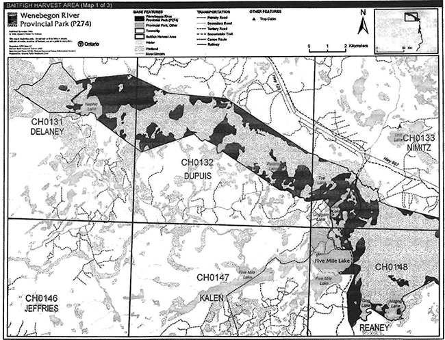
Figure 5a: Baitfish Harvest Area (PDF)
Figure 5b: Baitfish Harvest Area
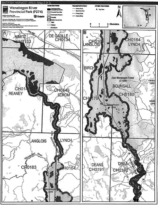
Figure 5b: Baitfish Harvest Area (PDF)
Figure 5c: Baitfish Harvest Area
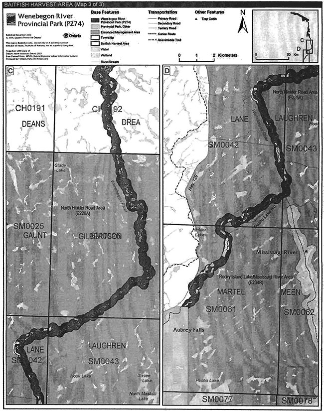
Figure 5c: Baitfish Harvest Area (PDF)
The use of ATVs on existing routes for access to private land in-holdings and LUPs is permitted to continue unless park values are threatened. Proposals for new trails may only be considered through future planning with public and Aboriginal consultation (OMNR 2000).
Off-road/off-trail use of all terrain vehicles will not be permitted within park boundaries unless authorized by the superintendent under the authority of the Provincial Parks Act.
Aircraft
Aircraft landings are permitted in the park (OMNR 2004a). All aircraft landings are subject to regulation and valid aircraft landing permits issued by the park superintendent under the authority of the Provincial Parks Act.
6.1.2 Non-motorized recreation
Camping
There are currently no developed campsites within Wenebegon River Provincial Park. There are several unmanaged dispersed backcountry campsites located within the park boundary which are associated with the canoe route (Figures 2a, 2b, and 2c). Unauthorized concentrations of vehiclebased camping off old roads or from unauthorized trails within the park are not permitted. Existing dispersed backcountry camping use may continue, unless park values are threatened (OMNR 2004a).
Ontario Parks may assess the condition of existing campsites and will maintain,rehabilitate, or close sites as required. If there is an identified need, new campsites may be. considered (OMNR 2004a). Infrastructure will be permitted in order to protect park features and values in response to use, environmental deterioration and environmental protection requirements. Any proposed development in the park must fulfill the requirements of the Environmental Assessment Act.
Hiking
There are no existing hiking trails within Wenebegon River Provincial Park.
If there is an identified need, the development of new hiking trails may be considered. Trail infrastructure to protect park values and features will be permitted. Any proposed development within the park is subject to Environmental Assessment Act requirements.
Canoeing/kayaking
Existing uses may continue, unless park values are threatened (OMNR 2004a). Infrastructure to protect park features and values may be permitted and developed in response to use, environmental deterioration and environmental protection requirements.
6.1.3 Emerging recreational uses
There are emerging recreational uses for which there is limited or no policy to deal with their management (e.g., adventure racing, geocaching). The park superintendent will use legislation, policy, and guidelines which are in place to manage emerging uses.
6.2 Development
The Wenebegon River Access Point, a designated (authorized) access point, is located in Lane Township and several informal access points occur along the waterway (Figure 2c). A formal canoe route occurs through the entire park - backcountry campsites are unmanaged.
Infrastructure to protect park features and values may be permitted and developed in response to use, environmental deterioration, and environmental protection requirements. Any proposed development within the park is subject to the Environmental Assessment Act.
6.3 Commercial tourism
There are four existing commercial tourism outpost camps under LUPs located within the park (Section 5.1.6). New commercial tourism facilities may be considered where they would be consistent with park policy (OMNR 2004a). Any development must meet the requirements of the Environmental Assessment Act.
7.0 Cultural Resources
An assessment of the cultural resources specific to Wenebegon River Provincial Park has not been conducted. The management of cultural values within the park will be directed toward protection and heritage appreciation (OMNR 1992).
8.0 Heritage education
Literature and other supporting information may be developed to describe the park in the context of Ontario’s provincial park system. Boundary limits, significant heritage features and permitted uses of the waterway park may be included in park literature.
Prospective park visitors may be informed. about the sensitivity and significance of park values through park literature.
9.0 Research
Scientific research by qualified individuals which contributes to the knowledge of natural or cultural history, or to environmental or recreational management, may be encouraged in the park. Ontario Parks will encourage institutions, such as universities, to undertake research projects.
All research programs will require the approval of Ontario Parks and are subject to park policy and other applicable legislation. Any materials removed from the park will remain the property of Ontario Parks.
Approved research activities and facilities will be compatible with the park’s protection objective. Any site which is affected by research will be rehabilitated as closely as possible to its original state. Environmental Assessment Act requirements will apply.
10.0 References
Arnup, R.W., 1991. Report on Reconnaissance Life Science Inventory for Reaney Township Peatlands Area of Natural and Scientific Interest (ANSI). Ecological Services for Planning Limited, Guelph, Timmins, Kapuskasing.
Blackburn, C. 2004. Earth Science Inventory Checklist. Wenebegon. Blackburn Geological Services. OMNR.
Environmental Assessment Act, 1990.
Fisheries Act, 1985.
Fish and Wildlife Conservation Act, 1997.
Harper, T., 2003. Wenebegon River Provincial Park (P274) Recreation Inventory Report Version 1.3. OMNR.
Lehman, T., 2006. Area Forester. Sudbury District MNR. Personal Communication.
Migratory Birds Convention Act, 1994.
Mining Act, 1990.
Morris, E. R., 2003. Natural Heritage Area - Life Science Checksheet. Wenebegon River Provincial Park (P274). OMNR.
Ontario Ministry of Natural Resources (OMNR), 1974. A Topical Organization of Ontario History. Historic Sites Branch Division of Parks.
OMNR, 1989. Chapleau District Fisheries Management Plan 1989-2000.
OMNR, 1992. Ontario Provincial Parks Planning and Management Policies.
OMNR, 1999. Ontario’s Living Legacy Land Use Strategy.
OMNR, 2000. Ontario’s Living Legacy Land Use Strategy (Policy Clarification).
OMNR, 2003a. Directions for Commercial Resource Use Activities in Provincial Parks and Conservation Reserves. 5 pp.
OMNR, 2003b. Public and Aboriginal Consultation Documentation Form Ontario’s Living Legacy Protected Area Boundary Refinement Review.
OMNR, 2004a. Crown Land Use Policy Atlas.
OMNR, 2004b. Fire Management Strategy for Ontario. Aviation and Fire Management Branch.
OMNR, 2005. A Class Environmental Assessment for Provincial Parks and Conservation Reserves.
OMNR, 2006. Provincial Parks and Conservation Reserves Act, Royal Assent June 2006, Proclamation Pending in first quarter of 2007.
Provincial Parks Act, 1990.
Appendix A: Background information
| Name | Wenebegon River Provincial Park |
|---|---|
| Classification | Waterway |
| Eco Region/Eco District | 4E-3 |
| OMNR Administrative Region/District | Northeast-Chapleau |
| Total Area (ha) | 16,383 |
| Regulation date and Number | June 7th, 2003 (O. Reg. 210/03) |
Representation
Earth Science: Archean age Abitibi and Wawa Subprovinces: Algoma granitic and gneissic rocks. Two suites: massive to foliated granodiorite to granite suite south of Wenebegon Lake; gneissic tonalite suite, consisting of foliated to gneissic tonalite to granodiorite with minor supracrustal inclusions, at north end.
Quaternary deposits are glacial outwash through which the river meanders at the southern end. Oxbow lakes and scars are common. Ground moraine over bedrock predominates in the central portion, around Wenebegon Lake. In the northern portion, organic terrain with string bogs overlies glacial outwash. Sand dunes are developed in the outwash materials near Gog and Magog lakes. An esker and kame complex crosses the park at Unegam Lake. The course of the river is strongly controlled by regional bedrock fracture pattern at the south end, following north northwesterly and east-northeasterly major fractures in a "dog leg" pattern.
Sensitivity
Glaciofluvial valley train or alluvial sands and gravels that have been exploited in the past, that are sensitive to any further human exploitation, are adequately protected by park status. Natural processes, mostly fluvial, will continue to operate, but not change the landscape in the foreseeable future.
Significance
The park provides a cross section through the central portion of a major granitic batholithic area of the Abitibi Subprovince. Outcrop is very limited. Other protected areas, especially along the Mississagi River system, cross the same batholithic area. Bedrock geology of the site is of local significance.
String bogs, esker remnant and sand dunes and the meandering of the river in its own valley, commonly constrained by bedrock cliffs on either side are good but not exceptional examples of these landform features - all of these are of local significance.
The "dog leg" pattern of the river imparted by underlying fracture systems is an excellent example of how bedrock geology can influence physiography and landforms in a major way, in this case influencing the course of the river. Other examples occur on the Mississagi River system, but this river probably has the best development in the Algoma highlands, and possibly throughout the park system - provincial significance.
Life science:
The designated Wenebegon River provincial Park extends from the northern extreme of Ecodistrict 4E-3 (near Chapleau) southward to Aubrey Falls Provincial Park, which is centrally-located in Ecodistrict 4E-3. It includes three principal representation types: peatland, river corridor, and a large lake. The peatlands are located in the northern portion of the park, immediately south of the junction of highways 129 and 667. North of the park is a feature known as the Chapleau Scarp, a major end moraine. The peatlands to the south (mostly inside the park) have developed over an area of glaciolacustrine and glaciofluvial fine sand, deposited under the preglacial Lake Sultan and rewo ked by te wind prior to the development of the peatlands (Arnup 1991). Two sections of these peatlands were designated as provincially significant (Crins 1996; Arnup 1991): the Dupuis Township Peatland and Reaney Township Patterned Peatland. The latter is particularly significant for its regionally unique patterning of bog, fen, coniferous swamp, and open pool wetlands (Arnup 1991).
Between the peatlands and Wenebegon Lake, the park includes the Little Wenebegon River and a 200 m terrestrial corridor, which passes through a sand and gravel glaciofluvial outwash plain. Most of the Jack Pine and Spruce forests in this area have been cut-over recently, including much of those within the 200 m terrestrial corridor. As such, the outer sections of the terrestrial corridor are sparsely vegetated with young trees and pioneer species, such as Pin Cherry.
The park includes Wenebegon Lake as well as a 200 m terrestrial representation around the perimeter. The lake itself supports a warm water fishery (Walleye) and includes several wetland types (fen, hardwood swamp, emergent and aquatic marshes). This terrestrial representation includes part of the East Wenebegon Lake Forest and Lowlands natural heritage area (Crins 1996), which was designated as provincially significant for its high concentration of White-Cedardominated forests. The remaining intact portions of this natural heritage area are designated as conservation reserve (C1548). Modest-sized stands of old-growth White Pine also occur on the eastern shore of Wenebegon Lake.
Between Wenebegon Lake and Aubrey Falls Provincial Park, the park includes the Wenebegon River and a 200m terrestrial corridor. This section of the park passes through sandy glaciofluvial outwash and alluvial plain deposits dominated by Jack Pine, coniferous and alder thickets near the river.
The extensive peatlands are provincially significant with regionally significant patterned peatland, white cedar and lowland forests.
Cultural resources:
An investigation and analysis of the cultural resources specific to Wenebegon River Provincial Park has not been completed.
Recreation:
Wenebegon Lake is a remote tourism destination. There are several unauthorized access points at various locations that allow for access to this lake. The Wenebegon River Access Point located in Lane Township is the only recognized access-point.
The Wenebegon River canoe route originates at Chene Lake just west of Highway 129. The route then follows the Wenebegon River to Wenebegon Lake and then to Aubrey Lake.
Unauthorized all-terrain vehicles (ATVs) and one authorized snowmobile trail are also present in the park area. Informal ATV trails have been cleared in the area to access the lake as well as outpost camps. These trails are generally extensions off of logging roads found adjacent to the park. A snowmobile trail, maintained by the Chapleau Arctic Watershed Snowmobile Club, roughly follows Highway 129 and crosses over the park in Reaney and Nimitz townships.
Recreation activity within the park is largely water-based. Fishing, canoeing, boating and camping are established recreational activities in the park.
Inventories
| Survey Type | Earth Science | Life Science | Cultural | Recreational |
|---|---|---|---|---|
| Reconnaissance | Blackburn, 2004 | Arnup, 1991; Morris, 2003 |
Harper, 2003 |
Footnotes
- footnote[1] Back to paragraph Transfers include situations where a license is surrendered with a request that it be immediately reissued to another individual or organization that is assuming an existing operation.Trap cabins are considered part of a trapline and would be transferred with the trapline for the purposes of trapping. If a trapline license is revoked or surrendered, all portions of the registered line within the park will be rescinded from the legal description of the trap line (OMNR 2003a).