Westmeath Provincial Park Management Plan
This document provides policy direction for the protection, development and management of Westmeath Provincial Park and its resources.
4366-1
0-7729-90 1 8-2
© 1991, Queen’s Printer for Ontario
Limited copies of this publication are obtainable from:
Ministry of Natural Resources
Pembroke District Office
Riverside Drive
Box 220
Pembroke, Ontario
K8A 6X4
Telephone 613-732-3661
Approval statement
Westmeath Provincial Park is one of the few undeveloped areas remaining along the Ottawa River in Ontario. Composed of an active sand spit extending into the river, Westmeath Provincial Park possesses a diversity of landforms including a sand dune system and a 1,980 metre sand beach. Representative and significant life science features also exist on the property including a dry beach community, lowland and upland forest community and a wetland.
We are pleased to approve the Westmeath Provincial Park Management Plan, as official policy for the management and development of this park. The plan reflects this Ministry’s intent to protect natural and cultural features of the Westmeath Provincial Park and develop high quality opportunities for outdoor recreation and heritage appreciation for both residents of Ontario and visitors to the Province.
A.J Stewart
Regional Director
Central Region (Huntsville)
Norm R. Richards
Director, Parks and
Natural Heritage Policy Branch
1.0 Introduction
Westmeath Provincial Park is one of the few undeveloped areas remaining along the Ottawa River in Ontario. Located on a large bend in the river, the park consists of 610 hectares, 353 of which are dry land. Situated 16.5 kilometres from the City of Pembroke (Figure 1), the park offers an excellent opportunity for a variety of low intensity outdoor recreational and educational activities. The park also provides protection for a variety of significant earth and life science features.
The Province of Ontario acquired the Westmeath property for a provincial park in 1984 after several years of negotiations with the landowners. Initially the Westmeath property had been approved for the development of a large residential subdivision. However, the involvement of groups such as the Pembroke Outdoor Sportsman’s Club, the Ontario Federation of Anglers and Hunters, and the Nature Conservancy of Canada resulted in the acquisition and protection of this unique property by the government. The property was put into regulation as a provincial park in May 1985 under Reg. No. 493/85.
The park is situated in the ancient Ottawa - Bonnechere rift valley. This valley is composed of Precambrian bedrock overlain by younger Middle Ordovician Iimestones and is covered by relatively deep postglacial lacustrine sands, modern alluvial sands, silts, clays and gravels, and recent organic deposits. The abundance of sands has contributed to the formation of an active sand spit, which constitutes sixty percent of the Westmeath Park area. The Westmeath sand spit is thought to be less than 5,000 years old and is the result of lacustrine processes (formed by lakes). Sand carried by the Ottawa River current was, and still is, continuously being deposited at this large bend in the river. The sand spit is slowly growing northeast into the Ottawa River, creating an enclosure for a large wetland known as Bellows Bay. Offshore bars indicate where sand is still being deposited. Sands moved inland by wave and current action, gradually form into dunes through wind action and then eventually become stabilized by growth of vegetation. The interior of the spit now supports a mature upland forest where, previously, active dunes had existed. An active dune system still remains along the western edge of the spit, backshore of a 1,980 metre sand beach.
Park development consists of a vacant cottage on the west side of the spit and an access road, which branches to run along both shores of the spit until converging once again near the cottage (Figure 2).
A number of significant earth science features are represented in the park. Westmeath Park contains such landforms as a simple spit, relict beach ridge, cuspate foreland, relict Ottawa terrace, foredune, parallel dune, and bayou. These landforms are regionally significant and the latter five have no comparative examples in the region.
The majority of the significant life science features within the park are of regional or local significance although some provincially significant species do exist as described in Sections 7.1 and 7.2. The dry beach community along the western shore of the spit supports a large number of regionally uncommon species as well as the provincially rare bulbostylis Bulbo stylis capillaris. The offshore marshes on the south side of Bellows Bay also have regionally unrepresented species such as wild rice Zizania aquatica. Extensive wet lowland forest communities, dominated by silver maple Acer saccharinum and black ash Fraxinus nigra, occur at the northern and southern ends of Bellows Bay. The silver maple, at the limit of its northern range, is also considered regionally significant.
Due to the variety of terrestrial and aquatic habitats, the park area supports a relatively wide diversity of faunal populations. The upland and lowland forest communities, sand beaches, offshore sand-bars, and the extensive marsh complex in Bellows Bay all provide habitat for typical mammal, reptile, amphibian, and bird species of the Great Lakes-St. Lawrence region. The sand beaches and Bellows Bay in particular, provide habitat for two unusual reptiles, the map turtle Graptemys geographica and the threatened eastern spiny soft-shelled turtle Trionyx spinhferus spiniferus.
The park is also of historical interest, as it is believed that Sand Point was used by Native peoples and perhaps by voyageurs and coureurs des bois during the fur trade.
Resource analysis indicates that Westmeath Provincial Park has good recreational potential as well as significant natural features. The Pembroke District Land Use Guidelines (DLUG) recognize the importance of Pembroke District as a recreation and tourism area. Westmeath Provincial Park will contribute to District (DLUG) targets by providing recreational opportunities such as swimming, picnicking, hiking and nature appreciation for local residents and visitors. As a day use facility, Westmeath Provincial Park will compensate for the lack of public shoreline and limited access to the waters along the Ottawa River. The park will satisfy local recreation needs and service non-local residents who have traveled to some of the local tourist destinations. The park will also contribute to the local economy by creating employment opportunities.
The Westmeath Provincial Park Management Plan provides policies, which will guide the careful development and management of the park for the next twenty years. The plan will identify the recreational opportunities available to the public and make provisions for the protection of the park’s natural and cultural features.
Figure 1: Regional context
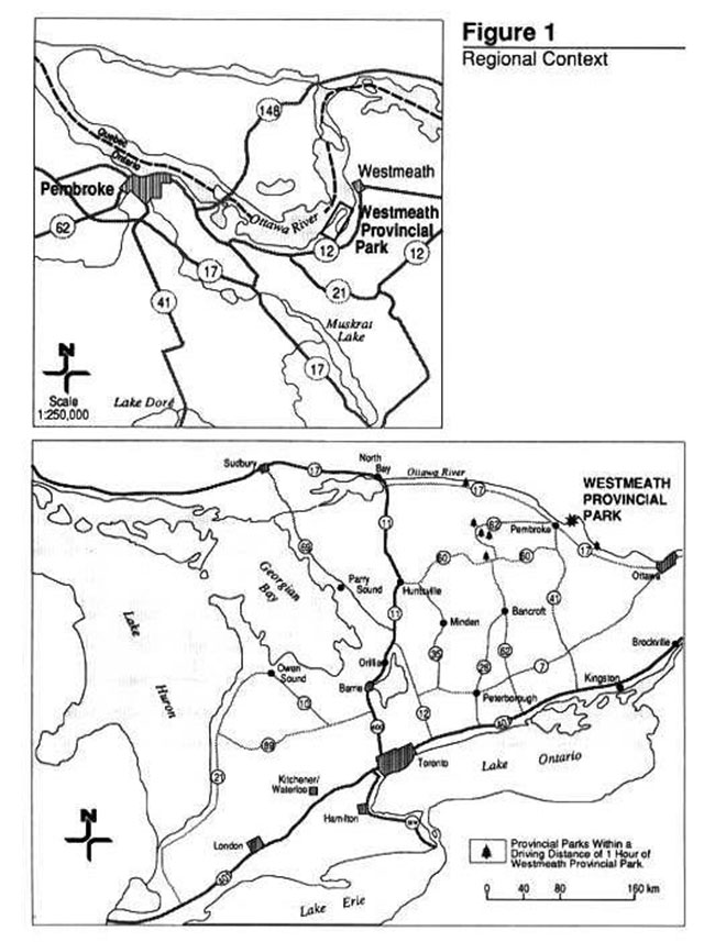
Enlarge Figure 1: Regional context
Figure 2: Existing development
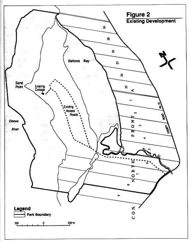
Enlarge Figure 2: Existing development
2.0 Classification
Westmeath Provincial Park is classified as a Natural Environment Park under the Provincial Park Classification System. Natural Environment Parks incorporate outstanding recreational landscapes with representative natural features to provide high quality recreational and educational experiences in a natural setting.
The Pembroke District Land Use Guidelines, approved in 1983 after extensive public consultation, identify Westmeath as a Natural Environment Class candidate park. Initially, the property was to be acquired for recreation purposes but the identification of several significant features in later studies indicated that a more protective mandate was required. The Natural Environment class of park would realize the recreation potential of the property while reducing the possibility of negatively impacting on those significant resources. The inability of Westmeath Provincial Park to meet size requirements of a Natural Environment Park classification was seen to be of minor importance considering its contribution to the park system targets and the limited land availability in southern Ontario.
The park contains many representative and significant examples of earth and life science features, including a dry beach community, dune system, lowland and upland forest community, and wetland.
Westmeath’s classification as a Natural Environment Park also recognizes the park’s tremendous potential as a year 'round recreational environment for low intensity use activities such as bathing, hiking, picnicking and cross-country skiing as well as its traditional use for waterfowl hunting. The park’s location near several urban centres adds to its recreational importance.
The park also offers substantial opportunities for outdoor education and research in light of its proximity to major educational centres and its natural and cultural resources.
The Natural Environment park classification is the most appropriate classification given the need to balance the protection and recreational use of the site. Westmeath Provincial Park will provide a unique opportunity to protect an important part of the natural heritage of the province as well as an opportunity to provide quality recreational opportunities to the people of the upper Ottawa Valley and visitors to the area.
3.0 Park goal
The goal of Westmeath Provincial Park is to protect an area of earth and life science significance while providing opportunities to enjoy a variety of quality low intensity outdoor recreational and educational experiences in a near urban setting.
4.0 Park objectives
Natural Environment Parks contribute to the achievement of all four Ontario Provincial Park objectives: protection, recreation, tourism and heritage appreciation.
4.1 Protection
To protect significant elements of the natural and cultural landscape of Westmeath Provincial Park.
The designation of Westmeath as a provincial park protects an area of earth and life science significance, representative of this section of eastern Ontario. Protecting the sensitive features of Westmeath Provincial Park is the foremost objective of the Management Plan. The protection of these features through zoning is important to the fulfillment of other park objectives including nature interpretation and education.
4.2 Heritage appreciation
To provide opportunities for exploration and appreciation of the outdoor natural and cultural heritage of Westmeath Provincial Park.
Westmeath Provincial Park is characteristic of the Ottawa River and its associated features. It also offers opportunities for high quality low-intensity day use recreational opportunities. Values such as post-glacial lacustrine and alluvial features, native campsites, marshes and wetlands and their representative flora and fauna will be protected by appropriate zoning and management direction, and will be emphasized in the visitor services program.
4.3 Recreation
To provide recreation opportunities in a day use setting for upper Ottawa Valley residents and visitors.
Westmeath Provincial Park will provide much needed opportunities for several outdoor activities. Recreation targets for each park in the Pembroke District are outlined in the 1983 Pembroke District Land Use Guidelines. From the District targets, Westmeath Provincial Park can provide for 54,000 swimming opportunities (50 percent of District’s total targets), 11,000 picnicking opportunities (20 percent of District’s total targets), as well as hiking and nature appreciation. However, the camping recreation target (16,000 opportunities) predicted for the park will not be attained. Overnight camping must be restricted to protect the significant features of the park. Westmeath also has the potential to accommodate controlled waterfowl hunting opportunities during the fall (the number of opportunities will be determined on an annual basis as described in Section 7.4). The restricted access and controlled visitor use will support the protection objective.
4.4 Tourism
To provide Ontario’s residents and out-of-province visitors with opportunities to discover and experience the distinctive features of Westmeath Provincial Park.
Westmeath Provincial Park will provide much needed recreation opportunities for residents of Pembroke District while enhancing the attraction of the area for travelers from elsewhere in the Province.
The operation of the park will be complementary to the tourism strategy for Renfrew County. In particular, it will add to the variety of existing attractions in Pembroke District such as the white-water rafting industry and local area campgrounds.
5.0 Park boundary
It has been proposed that a series of 91 metre in width conservation easements (consisting of 104 hectares in total) be established along the entire south-eastern shore of Bellows Bay for park management, wildlife management and access control purposes (Figure 3). A separate easement will be needed for each landowner. Development has not occurred within this area and no recreational activities are anticipated.
This area has traditionally been used as an access route into Bellows Bay during the fall hunting season. Negotiating these conservation easements will facilitate waterfowl management and alleviate safety concerns. The proposed easements will serve to protect the private property rights of landowners and reduce the probability of trespassing. The Ministry has entered into preliminary discussions with the owners of Lots 1 to 6 and 25 to 29 of North Front 'A' Westmeath Township in order to negotiate the acquisition of these easements prior to the park’s operation.
6.0 Park zoning
Park zoning allocates a park’s land and water on the basis of its significance for protection and its potential for recreation within the context of the park’s classification. The majority of Westmeath Provincial Park’s land base (47%) is zoned Nature Reserve while the remainder is comprised of Natural Environment (39%), Development (8%) and Access Zones (6%) (Figure 3). The section of the Ottawa River included within the park’s boundary, (approximately 257 hectares) is zoned Natural Environment except for approximately 4 hectares of Development Zone -1.
The park’s significant earth and life science features, which require distinct protection and management measures, are included in the Nature Reserve Zones.
The Natural Environment Zones encompass most of the remaining landscape in which a minimum of development is required to support low intensity uses such as hiking, bird watching, photography, etc. Waterfowl hunting will only be permitted during the fall within Natural Environment Zone-i. The activity will be controlled and regulated in that prescribed area (refer to Section 7.4 for additional information).
Facilities and services which provide for day use activities are provided in a Development Zone. The provision of these facilities and services will be considered in relation to the carrying capacity of the site and the possible impact on surrounding zones. Park administrative control facilities and a small group camping area will also be provided in a Development Zone near the entrance to the park.
The transportation and utility corridor into the park will be contained within the Access Zone.
The major resources in each zone, as well as permitted recreational uses and development, are listed below by zone type. A list of permitted uses for each zone is included in the document entitled Ontario Provincial Park Planning and Management Policies. All uses and facilities within the various zones will be subject to the Resource Management Policies outlined in Section 7.0 of this Management Plan.
6.1 Nature Reserve (>NR) Zones
The park contains three Nature Reserve Zones. They encompass the following areas of earth and life science significance: Sand Point, the cuspate foreland, and the southern end of Bellows Bay (Figure 3).
These zones were designed to include, as much as possible, those significant features identified in preliminary inventories. Almost 50 percent of Westmeath Provincial Park’s land base has been designated Nature Reserve Zones to protect its significant features. Large buffer areas surrounding the sensitive features have been incorporated into the zones to provide additional protection.
Development in the Nature Reserve Zones will be limited to interpretive hiking trails and signs necessary for trail identification or interpretation. A trail and boardwalk system will enable visitors to view the significant features from an appropriate distance yet also function to control pedestrian traffic through the sensitive areas.
NR-1 Bellows Bay Nature Reserve (55 ha)
Bellows Bay is characterized by open water with a border of wet meadow in the northern end and a complex marsh community in the southern end. In the south end, wild rice, bulrush Scirpus flu viatilus, and sweet flag Acorus calamus constitute a large proportion of the wetland complex. The southern end of Bellows Bay is also dominated by a forest complex consisting of predominately silver maple, with green ash Fraxinus pennsylvanica, black ash and bur oak Quercus macrocarpa. Significant species include silver maple, blue beech and a southern shrub species, prickly ash Xanothoxylum americanum, which are at their northern ranges.
The extensive marsh complex in the south end of Bellows Bay has been identified as an important staging and resting area for waterfowl species such as mallard Anas platyrhynchos, black duck Anas rubripes, wood duck Aix sponsa, blue-winged teal Anas discors, green-winged teal Anas crecca, goldeneye Bucephala clangula and lesser scaup Aythya affinis. Bellows Bay is also an ideal habitat for a variety of amphibians and reptiles, including two unusual species of turtles, the map turtle and the threatened eastern spiny soft-shelled turtle.
The development of simple observation platforms will be permitted within this zone.
NR-2 Sand Point Nature Reserve (24 ha)
The Sand Point Nature Reserve encloses Sand Point at the extreme northwestern end of the peninsula and extends in an easterly direction towards the channel of Bellows Bay (Figure 3). The offshore littoral zone is also incorporated within this zone, its boundary established at low water level.
Sand Point is significant for the variety of unusual plant species which it supports such as cocklebur Xanthium strumarium, golden hyssop Gratiola aurea, and silverweed Potentila anserina. The tip of Sand Point is distinguished from the rest of the park by the presence of cobbles and large boulders of limestone and dolomite. Just east of this point, archaeological evidence indicates the area had been used by native peoples (Section 7.5). Further east a relict beach ridge, reminiscent of higher water levels on the ancestral Ottawa River, is also evident.
A dry thicket community, located on the beach ridge, was identified as regionally significant because it represents the early successional stages of a dry upland red pine forest. This area primarily consists of young red pine with an understory of staghorn sumac but also contains such notable species as umbrella sedge Cyperus filiculmis, frostweed Helianthemum bicknelli jointweed Polygonella articulatas, and sand dropseed Sporobolus cryptandrus. In the vicinity, significant plant species such as butternut Juglans acinerea and silver maple also reside.
NR-3 Cuspate Foreland Nature Reserve (81 ha)
The cuspate foreland represents the convergence of two sand spits. It is an active system consisting of an assemblage of significant landforms, which include: a cuspate spit, beach ridges, foredunes, parallel dunes and several former lagoons. This array of features provide an excellent example of succession and a habitat for a variety of unusual plant species.
Figure 3: Zoning and proposed conservation easement
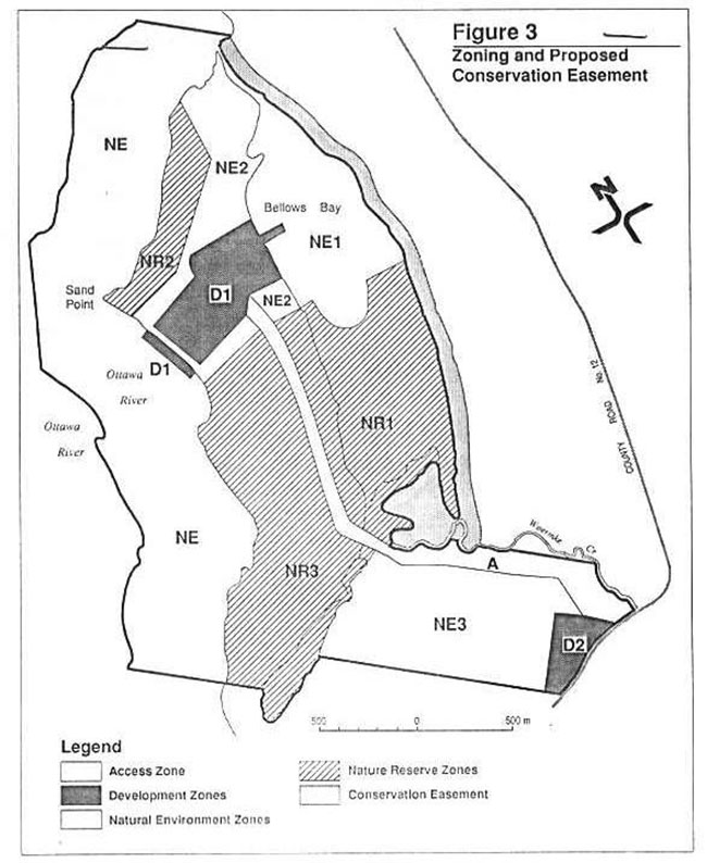
Enlarge Figure 3: Zoning and proposed conservation easement
Figure 4: Significant features
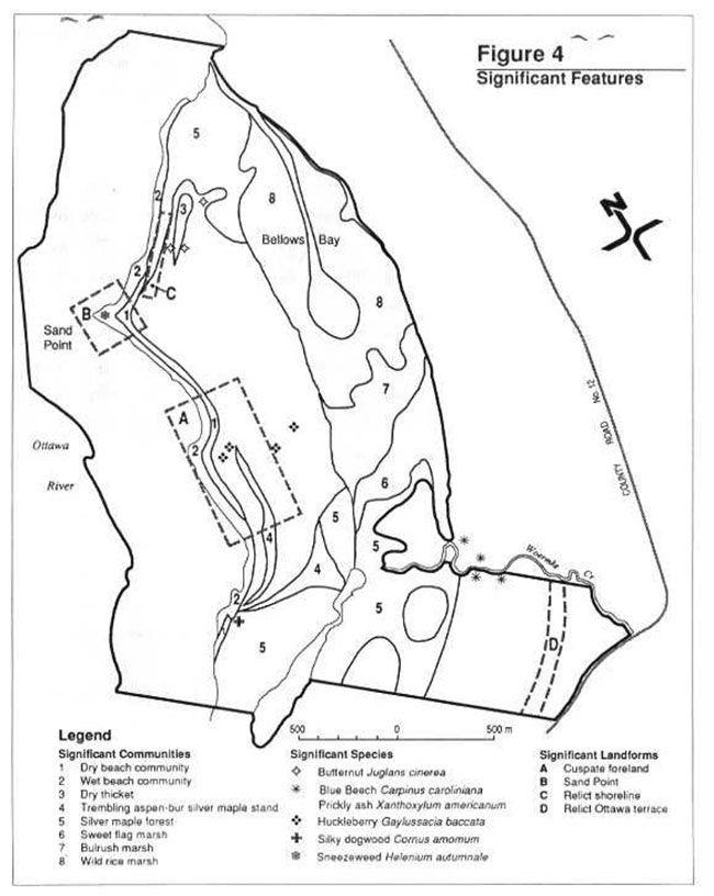
Enlarge Figure 4: Significant features
The dry beach community along the western shore of the spit supports a large aggregation of regionally uncommon species such as sagewort wormwood Artemisia campestris, Canada wild-rye Elymus canadensis, jointwood, hudsonia Hudsonia tomentosa, umbrella sedge, little bluestem Andropogon scoparius, frostweed, and the provincially rare bufbostylis.
The offshore littoral zone is also incorporated within this zone, its boundary established at low water level. In the offshore marshes on the west side of this zone, regionally uncommon species such as cordgrass Spartina pectinata and bulrush Scirpus americana exist. Interesting lowland thickets of meadow sweet Spiraea latifolia, black alder hex verticillata, and cranberry Vaccinium macrocarpon also occur in the former lagoons located on the cuspate foreland.
In the centre of the NR-3 Zone, a 20 hectare mature (approximately 80 years old) red pine forest community exists. The over-mature jack pine in the stand have been dying and falling down, and the red pine are expected to respond similarly as they continue to mature.
The continuous sand beach and offshore sand bars are also excellent habitat for shorebirds such as killdeer Charadrius vociferus, sanderling Cahidris alba, herring gull Larus argentatus, and the common tern Sterna hirundo. The beaches and sandbars also provide habitat for turtles, including map turtle and spiny soft-shelled turtle.
The cuspate foreland is very sensitive to disturbance and must be protected from human impact. Interpretive trails will not be permitted in the sensitive areas of this zone but will, instead, travel around them for viewing purposes.
6.2 Natural Environment (NE) Zones
Natural Environment Zones include sections of the park in which minimum development is required to support low intensity recreational activities in aesthetic landscapes. Development will be limited to hiking and cross-country ski trails, viewing platforms signs necessary for trail identification, and minimal interpretive facilities. There will be four Natural Environment Zones in the park; that portion of the Ottawa River included within the park and the following three land based zones.
NE- i Bellows Bay Natural Environment Zone (51 ha)
This Natural Environment Zone covers the northern half of Bellows Bay. The natural environment designation of this area provides a protective function similar to the adjacent Nature Reserve Zone. However, this zone will permit fishing and traditional water fowl hunting. These activities will be managed in accordance with the Westmeath Provincial Park Wildlife Management Strategy (as described in Section 7.4).
Development within this zone will be limited to waterfowl observation platforms. A boat launching system to access Bellows Bay is provided in the adjacent Development-1 Zone.
NE-2 Sand Dunes Natural Environment Zone (26 ha)
The Sand Dunes Natural Environment Zone covers approximately half of the northern end of the Westmeath Peninsula. It protects the northeast end of the sand spit and surrounds the Development-1 Zone, creating a buffer for the neighbouring Nature Reserve Zones. Significant features include portions of a silver maple stand, butternut grove, and wet and dry beach system (Figure 4). This Natural Environment Zone also extends between the beach and parking areas to encompass the sensitive sand dunes, which exist there. The sensitivity of the sand dunes, situated between the two proposed development areas, warrants specific management and design considerations, which are discussed in Sections 7.1 and 13.0.
NE-3 Relict Terrace Natural Environment Zone (56 ha)
This zone encompasses a wooded area of land near the entrance to the park and includes the relict terrace or shore bluff of the old Ottawa River shoreline.
6.3 Development (D) Zones
Development Zones provide access, facilities and services for camping and day use activities.
D-1 Day Use Area Development Zone (23 ha)
Development-1 Zone (Figure 3) is located near the northwest end of the property and encompasses the existing unoccupied cottage (Figure 2) and garage. This zone will be designed to accommodate low intensity day use activities such as swimming, hiking picnicking, and cross-country skiing. This area incorporates 8 percent of the total land base and uses approximately 17 percent of the available beach resource (the remaining beach resource resides in Nature Reserve Zones).
The access road will terminate in the parking area of the Development-1 Zone. Parking for 100 vehicles will be provided well back (minimum 50 metres) from the section of the active dune system, which is located adjacent to this zone. This sensitive dune system runs along the length of the beach but only 17 percent of it extends between these development zones. Thus, the strategy for development includes placing all facilities at a distance from this sensitive feature. The most appropriate location will be chosen based on the greatest degree of visitor control and least impact on the landscape. Toilet and change house facilities, picnic site, and a park office/visitor centre will be situated adjacent to the parking area. Access to the beach will consist of boardwalks originating from this development area and crossing over the sensitive dunes to the beach.
A dock will be installed on the western shore of Bellows Bay to permit wildlife observation and boat access (see Section 13.5 and accompanying figure for more details).
D-2 Park entrance Development Zone (6 ha)
Development-2 Zone is situated at the base of the Access Zone, near the entrance to the park. A control office will be located here to monitor and direct traffic entering the park. A maintenance compound will also be constructed, out of the view of park visitors. This zone will also contain t he group camping area as well as parking facilities for the group campers and winter visitors.
6.4 Access (A) Zone
The Access Zone follows an existing bush road on the property which originates from County Road 12 and extends to the Development-1 Zone. A secondary branch of the road which runs parallel to the western shore of the spit has been incorporated into the Cuspate Foreland Nature Reserve Zone (see Figure 2, 3, and Section 13.1).
Hydro and telephone utilities will be accommodated within the Access Zone. To improve aesthetics, and for convenience, underground utilities will be installed where possible during road construction.
7.0 Resource management
Management of the resources within Westmeath Provincial Park will be carried out in accordance with this Park Management Plan as well as the more detailed Landform, Vegetation and Wildlife Resource Management Strategies. The Park Operating Plan (Section 9), which will outline specific operational guidelines for the management of the park, will also conform to these specific resource management strategies. All resource strategies will conform to the Ontario Provincial Parks Planning and Management Policies.
7.1 Landform management
Westmeath Provincial Park possesses several significant earth science features. Three of these features are in proximity to visitor traffic and will deserve careful management as outlined in a Landform Management Strategy.
One of the most prominent and sensitive features of Westmeath Provincial Park are the sand dunes. The active dune system is located behind the beach, which borders the Ottawa River. Since this dune system extends along the length of the beach, the section which passes through the Development-1 Zone is susceptible to erosion from visitor traffic. For this reason, pedestrian travel over the dunes must be restricted to boardwalks accessing the beach at two or three locations. Other park facilities such as change houses and vault privies will be connected to the entrance of the boardwalk system as referred to in Section 13.1 and Figure 5. The sand dunes will also be protected through visitor education (visitor centre information and displays, park brochures, interpretive hikes, etc.) as well as site monitoring by park staff. Signs posted at the boundaries of the Nature Reserve Zones will also discourage entry into the zones and if necessary restrictive devices (e.g. fences) will be installed if signs or warnings are not effective.
The cuspate foreland area is very unique as it represents the convergence of two sand spits and provides a representative example of the evolution of a sand bar. The significant features in this area as well as those on Sand Point are protected within Nature Reserve Zones, which incorporate large internal buffers. These Nature Reserve Zones are also buffered from the adjacent Development Zone by the Natural Environment-2 Zone (Figure 3). Access to these landforms from the Development Zone will be deterred through visitor education and information, site monitoring, posted signs and restrictive devices, if required. Self-guided hikes through these areas will be strictly confined to a trail and boardwalk system. This will enable visitors to view the interpretive features from an appropriate distance without causing damage to them.
7.2 Vegetation management
A Vegetation Management Strategy will be prepared to manage the vegetative resources in the park.
Commercial forestry operations will not be permitted within the park. However, a 4 hectare area of planted red pine will be treated for management purposes by Ministry staff. Situated near the entrance to the park, the plantation is located partially within the NE-3 Zone and the Access Zone. Forest management prescriptions may entail periodic thinning to encourage increased stand growth, vigour and natural regeneration.
Trees along the sides of the roads or trails, which are considered hazardous (dead or in danger of falling) to visitors, will be removed up to a distance of 35 metres (the maximum height of the trees). Trees cut for development or management purposes will have their products retained for various uses in the Provincial Parks System. Non-native plant species will not be introduced in the park.
No vegetation management procedures will be implemented in Bellows Bay. All vegetation in both the Nature Reserve and Natural Environment Zone will be left to evolve naturally and will not be removed to facilitate other activities (i.e. boat movement for waterfowl hunting, fishing). However, non-native introduced species such as purple loosestrife Lythrum salicaria, an overwhelming and indestructible plant, may be controlled to protect the values of the bay. Commercial harvesting of wild rice will not be permitted.
Aquatic vegetation along the shore of the Ottawa River will be left in its natural state except for a small swimming area in the Development Zone. Visitor activity in that area should impede vegetative growth but it may be necessary to mechanically remove undesirable growth.
Poison ivy is prevalent through the park but will only be controlled, if warranted, in the Development Zone. Extensive patches likely to cause harm or which are unavoidable in the developed areas will be posted with warning signs or removed if necessary. Signs and public information will warn visitors of poison ivy in other areas of the park. It is anticipated that the signs posted to warn of poison ivy will act as a management tool to deter visitors from wandering into areas of the park which are being protected from visitor impact (i.e. Nature Reserve Zones) .
Insects and diseases threatening park values will be controlled where feasible and desirable. Where pest control is required, it will be directed as narrowly as possible to the specific insect or disease so as to have minimal effects on other parts of the environment. Biological control will be used wherever feasible.
In park policy, natural fires occurring in Nature Reserve Zones would normally be allowed to burn unless they threatened human life, other zones, or lands outside the park. However, in the case of Westmeath, due to its size and proximity to development areas outside the Park, normal methods of fire suppression will be carried out to protect the whole park area, including Nature Reserve Zones. Decisions on appropriate fire suppression tactic s will be made by the designated fire staff; however, no chemicals will be used in fire suppression.
7.3 Fisheries management
Sport fishing is permitted in Westmeath Provincial Park. Bellows Bay and the portion of the Ottawa River included in the park will be managed as a warm water fishery in accordance with the Pembroke District Fisheries Management Plan. The portion of Bellows Bay within Bellows Bay Nature Reserve-1 may be closed to anglers temporarily or permanently for research or management purposes.
7.4 Wildlife management
Westmeath Park possesses one of the most productive wetlands in Renfrew County. Bellows Bay is considered a Class 2 Provincial Wetland and provides a breeding, feeding and staging area for a variety of waterfowl, as well as natural habitat for unusual turtle species such as map turtles and the threatened eastern spiny soft-shell turtle. A Wildlife Management Strategy will be developed for the park. This strategy will outline management guidelines for the park’s wildlife and wildlife habitat and identify permitted uses as well as establish controls and regulations for waterfowl hunting.
Waterfowl productivity may be enhanced through monitoring and the provision of waterfowl nesting structures. Provision of suitable nesting structures could enhance the existing population and perhaps attract new species of birds and waterfowl. Several waterfowl observation areas, including a viewing platform, will be developed around Bellows Bay to enhance waterfowl and wildlife viewing opportunities.
Waterfowl hunting will continue to be permitted during the fall hunting season within the Natural Environment-1 Zone and will be governed by regulations under the Migratory Birds Convention Act and by the Ontario Game and Fish Act as well as the approved Westmeath Provincial Park Wildlife Management Strategy. Waterfowl productivity will be an important factor in determining seasonal hunting opportunities. Hunting will be strictly controlled in terms of access, number of hunters and blinds, blindlocations, safety, etc. The length of the hunting season as well as hunt times may be restricted by the Ministry should conditions warrant. Restricted access or location may be imposed on specific park uses to avoid conflicts and in the interest of public safety. During the fall, the boundaries of the hunting (NE -i) zone will be well defined and the area will be regularly patrolled by Ministry staff. Details of the operation of the waterfowl hunt will be outlined in the Wildlife Management Strategy. Hunting should not lessen the protective function of the adjacent Nature Reserve Zone because of the removed location of preferred resting areas in the Nature Reserve Zone, hunter controls and regulations, and the controlled duration of the hunting season.
Hunting of any species other than waterfowl will not be permitted within Westmeath Provincial Park.
Commercial trapping will not be permitted in the park. Certain animal populations may be controlled when necessary, to protect human health, and the safety or health of plant and animal species both inside and outside the park. Elimination of nuisance beaver may be required to ensure fisheries and wildlife management are not impeded. In Bellows Bay, the elimination of beaver may be permitted to allow natural fluctuations in water level. Natural water fluctuations will provide the best management of the vegetative, fish and wildlife communities in the bay. Where control is required, techniques will be used which have a minimal effect on the park’s environment. Any special population control measures will be carried out under the strict supervision of/or directly by the Ministry of Natural Resources.
7.5 Cultural resource management
An archaeological overview of the Westmeath Provincial Park property was carried out several years ago. It indicated that Sand Point may have been used as a campsite during the era when the Ottawa River was a major transportation route for explorers, fur traders and lumbermen.
A preliminary archaeological examination of the property has since been completed. This assessment focused on the Sand Point area and the Development-1 Zone. Archaeological evidence (flint, bone and charcoal fragments), retrieved east of Sand Point, supported the notion that native peoples may have frequently visited the site. However, there was no confirmation of a potential settlement site. Furthermore, there was no evidence to indicate that either area supported a possible camping site for voyageurs or explorers as they traveled this route. It can be considered more probable that they followed the opposite shoreline for expediency reasons and thus used the more prominent points across the river. While further investigations will be conducted, this brief survey suggested that any future development in the Development Zone will not conflict with any future archaeological finds.
8.0 Recreation management
Recreation management in Westmeath Provincial Park will promote low intensity day use opportunities while ensuring the protection of the park’s natural features.
The majority of visitors will be concentrated within the designated day use area (Development -1 Zone) or along the interpretive trail system. No car campgrounds will be developed in the park. The two parking areas will limit the number of visitors to the park at any one time. Visitor use is anticipated to be highest on weekends during the summer. Appropriate staff will be provided during summer weekends for access control and interpretive programs. Frequent staff patrols are required to ensure that park rules are being followed.
A sign plan will be developed for the park to direct people and provide specific information on the park’s resources and facilities. Garbage collection will be provided at various locations on the beach and in the backshore areas with an emphasis on centralized facilities. Change houses and washroom facilities will be provided for park visitors adjacent to the parking area, and will be accessible to the boardwalk system (see Section 13.1).
Concession stands will not be allowed within the park in order to preserve the natural atmosphere. Boat launching facilities will not be provided on the Ottawa River. However a launching system for small boats will be available on the west shore of Bellows Bay in the Development-1 Zone. This will enable pedestrian observation from its length as well as access to the water by seasonal fishermen or hunters. Conflicts between wildlife viewers and hunters will be avoided through the segregated location and time period of each activity, staff monitoring, and enforced hunting rules and regulations.
Motorized vehicles such as trail bikes, snowmobiles or ATVs will be prohibited within the park other than for management purposes. Horseback riding will not be permitted.
Group camping (for boy Scouts, girl guides, nature clubs etc.) will be provided in the Development Zone near the park entrance. Party size will be determined according to the carrying capacity of the designated site. Groups wishing to camp must receive pre-authorization from the Park Superintendent.
Cross-country skiing may be promoted in the park during the winter. Access to the ski trails will be provided at the entrance to the park by County Road No. 12 where trail guides will also be available.
9.0 Operations policies
A Park Operating Plan will be prepared to provide park staff with the necessary information to operate the park on a day to day basis. The operations plan will include such topics as budget, staffing, maintenance schedules, enforcement and emergency services. The provisions of the plan will be consistent with the approved Ontario Provincial Parks Operating Standards, and will be reviewed annually and updated as required.
10.0 Visitor services
Westmeath Provincial Park can provide opportunities for a variety of recreational activities as well as the enjoyment and appreciation of the park’s natural environment. Information describing the park will stress the protection of the unique natural features, which are representative of this region. Interpretation of their significance or ecological relationships is also an important component of visitor services.
Westmeath Provincial Park will offer year 'round visitor services programs. During the summer this program will promote interaction between park visitors and staff. During the remainder of the year most information on the park will be provided in the form of published maps and brochures.
It is anticipated that most visitors to the park will be small groups or families from the City of Pembroke, the Town of Renfrew and the surrounding area who wish to enjoy the scenic amenities of the Ottawa River. Currently, there is very little public access to the river east of the Village of Petawawa. Visitation may also be expected from tourists in the area. In addition, the two Renfrew County School Boards may use the park for outdoor education programs.
A park office/visitor centre will be provided in the existing cottage on the property. An access control building will be constructed near the entrance to the park to provide information and direct visitors. Park facilities will be designed to accommodate, as much as possible, visitors of all ages and those who are physically challenged. Boardwalks and the relatively flat terrain will make the beach area and hiking trails easily accessible. It is anticipated that the park will receive the greatest use on weekends during the months of June, July and August. However, the park will also be accessible most of the year for activities such as hiking and cross-country skiing.
The Visitor Services Program (seasonal activity level) will consist of three components: Information, Interpretation and Recreation.
10.1 Information
Information available to the visitors will describe the natural, historical, and cultural features of the park in terms of their level of significance, and their educational, scientific and research values. Protection of this unique and natural environment will be emphasized in all forms of communication.
Information will be provided to the public using print, displays, audio-visual media, and staff interpretation. Park brochures, leaflets, trail guides, newsletters, and specific information on the natural features of the park will be prepared as part of the information program. These will be available in the visit or centre/park office along with the audio-visual media and displays.
Permanent site displays or signs at the location of significant features may also be used to educate visitors. For example, a display could be positioned on the boardwalk to inform visitors about the dune system over which they cross. Personal contact between visitors and park staff is also important for information delivery. This will be promoted at the Visitor Centre, through the development and implementation of guided interpretive hikes and through enforcement of park regulations.
10.2 Interpretation
In conjunction with the available information, an interpretive program will advance the protection and heritage appreciation objectives of the park. The park’s location, as well as the presence of several regionally and provincially significant features, contribute to the park’s excellent educational, interpretive, and scientific potential. Information and interpretation of the earth and life science features will also encourage protection of these features.
The variety of fauna and flora in the park as well as the unique earth science features will form part of the interpretive program for park visitors. The evolution, present status, and characteristic features of earth science features will also be discussed in the visitor services interpretive program. The cuspate foreland provides an excellent example of the sequential development of the Westmeath sand spit. Interpretation of the sand spit will describe the evolution of this landform from its initial creation and the subsequent formation of Bellows Bay to its presently active state to its future state. Both guided and self-guided interpretive hikes will be offered in the park as well as passive recreational activities. In addition, the park could be of educational value to school groups for day excursions. Interpretation of the various earth and life science features represented in Westmeath Provincial Park could be incorporated into their respective curriculums.
10.3 Recreation
As a Natural Environment day use park, the visitor services program will emphasize information delivery and interpretation of the park’s natural features. However, some special programs will be directed at recreation skill training, such as photography, bird watching and skiing. These activities will relate to the park’s resources and be consistent with the objectives of the park.
11.0 Research
Scientific research by qualified individuals, which may contribute to the knowledge of the park’s natural an d cultural history or to environmental and recreational management, will be encouraged.
A preliminary archaeological investigation of Development -1 Zone indicated there were no artifacts located in that area. Further archaeological surveys in the park may provide evidence of historical native or voyageur visitation, which could form part of the park’s interpretive program. Other potential research topics may include earth science (dry beach, dune formation), significant plant communities, waterfowl habitat and fisheries research.
All research programs will require the approval of the Ministry of Natural Resources' District Office at Pembroke, and must meet all requirements under applicable provincial and federal legislation. Approved research activities and facilities will be compatible with protection objectives and recreational uses in the park. They will also be subject to development and management policies for Natural Environment Parks unless otherwise permitted. Sites altered by research activities will be rehabilitated to as close to their original condition as possible.
12.0 Marketing
Westmeath Provincial Park will be promoted as a day use park. A marketing plan to attract visitors to Westmeath Provincial Park will be prepared according to the foll owing objectives:
- To establish a marketing theme
- To make local and regional residents aware of the park
- To attract visitors during low use periods (mid week during June, July and August as well as during the fall and winter)
- To encourage the interaction of the park with existing private tourist operators and the local commercial sector (i.e. nearby private campgrounds, whitewater rafting operations)
- To encourage the preparation of research articles on the park
- To encourage the use of the park by the two Renfrew County School Boards
Promotion of Westmeath Provincial Park will occur throughout Renfrew County as part of the Renfrew Whitewater Country Tourism Strategy. The Ministry of Natural Resources will also continue to work with the Upper Ottawa Valley Tourist Association and the Ministry of Tourism and Recreation to promote the park.
The Ministry of Natural Resources will comply with the Ministry of Transportation and the County of Renfrew guidelines in erecting signs along highways and secondary roads leading to the park.
13.0 Development
Development within Westmeath Provincial Park will be kept to a minimum and restricted to the Access and Development Zones. The location and design of all facilities will reflect the character of the surrounding natural environment. Development will be carried out in accordance with approved site and development plans and managed in accordance with a Park Operating Plan. Development will proceed according to guidelines outlined in the Development Standards Manual provided by the Ministry of Natural Resources. The following facilities or services are necessary for the successful operation of the park and will be supplied through Ministry of Natural Resources' work planning programs and spec ial projects funding.
13.1 Access and circulation
The park access road will follow one of two existing bush roads (refer to Figure 2 for existing roadways). The preferred roadway, which follows the shore of Bellows Bay, will be upgraded to handle two-way traffic. This road, as opposed to the alternative, was selected so the area to the west of it could be incorporated into Nature Reserve Zone 3. This would provide more buffer for the sensitive cuspate foreland and dune system and reduce the possibility of unauthorized access into the zone. The other access road, adjacent to the shore of the Ottawa River, will be used as part of the primary hiking and cross-country ski trail. During the operating season the access road will be closed at night to prohibit unauthorized entry. During the winter the access road will not be ploughed but parking will be available at the entrance to the Park.
The proposed access road will split in the Development -1 Zone to form a one-way traffic loop through the day use area. Two parking areas for 50 vehicles each will be developed within the backshore area of the Development Zone. These parking areas will be situated no closer than 50 metres to the beach (Figure 5). Visitor capacity calculations for the beach and backshore area indicate that the park could accommodate a third parking area, also for 50 vehicles. However, this parking area will only be developed in the future should demand warrant it and based upon an environmental assessment of user impact on the park to be undertaken by the Ministry of Natural Resources.
A pathway and boardwalk, accessible to the physically challenged, will be developed from each parking area to the beach. This will provide the only access to the beach from the parking area, picnic area, and associated facilities (change houses and washrooms). Thus, the boardwalk will channel pedestrian traffic and prevent trampling of the sensitive dune system located between the beach and the backshore development area.
The existing access to Bellows Bay will be upgraded and a parking area for vehicles provided in a cleared area near the shore. A small parking area will also be developed at the entrance to the park near County Road No. 12. This will provide parking for group camping and cross-country skiing.
13.2 Services
Electrical services must be brought into the Development Zones from County Road No. 12. The gatehouse, park office/visitor centre and maintenance compound all require electrical service. These services should be installed at the same time the road is upgraded and preferably located underground.
Water will be obtained from a well in Development -1 Zone for the park office/visitor centre. Testing of the existing well is required to assess its suitability. An additional water source will be required at the park gate for group camping and the maintenance compound.
13.3 Administration and operation facilities
The existing cottage in the Development - 1 Zone will be converted into a park office (and combined visitor centre) for administrative operations. A small gatehouse will be constructed in Development- 2 Zone at the entrance to the park near County Road No. 12. Park literature will be distributed from this location during peak season or it will be obtained on a self-serve basis during the spring, fall and winter.
A maintenance compound area will be developed within Development-2 Zone. This compound will be fenced and situated Out of view of park visitors.
Figure 5: Future development
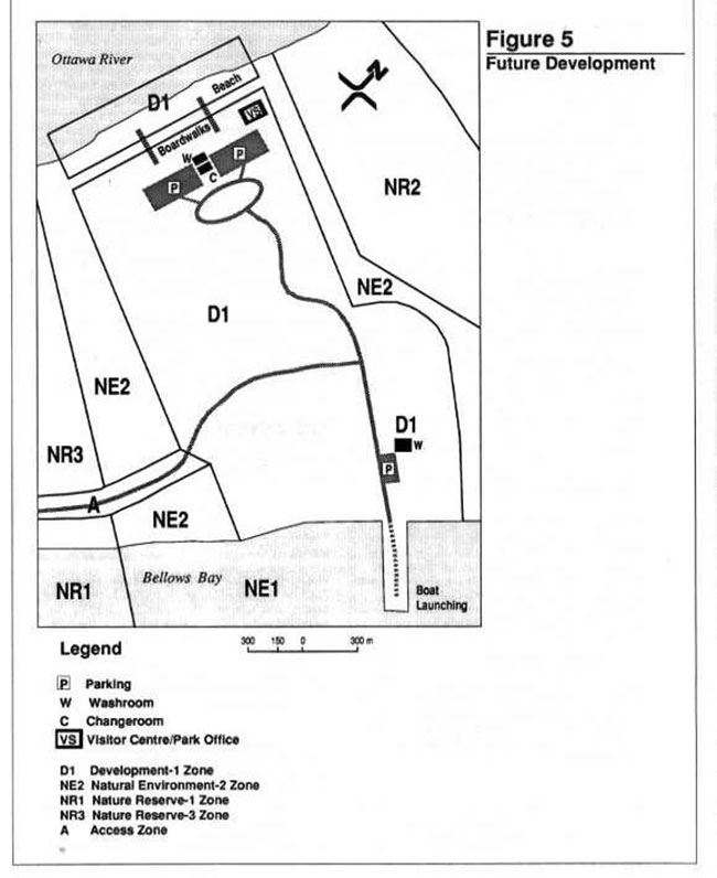
Enlarge Figure 5: Future development
13.4 Visitor services facilities
The existing buildings (cottage and garage) wi ll be renovated and used as visitor services facilities. The cottage will be converted to a visitor centre and combined park office. This park office/visitor centre will accommodate the various components of the Visitor Services Program as well as the park administrative operations. The garage may be developed as a workshop and demonstration area.
13.5 Recreation facilities
Swimming and beach activities are predicted to be the most popular activities in Westmeath Provincial Park. Development-1 Zone includes 350 metres of sand beach, which is at least 10 metres wide. The water is shallow, maintaining a depth of 1 to 1 .5 metres for several hundred metres, making Westmeath an ideal beach for young families. The beach area will be kept natural in appearance with minimal removal of aquatic vegetation. If removal of aquatic vegetation is required along the designated swimming area, it will be conducted in an environmentally safe manner. Clam shells and snails may also become a problem for swimmers and will be removed from the active beach area if necessary. It is anticipated that the frequent use of the beach area will discourage the establishment of vegetation and the presence of clams.
Change houses and washroom facilities will be constructed at the start of t he boardwalks near the parking areas. The picnic area will also be located adjacent to the parking area, facilities and park office/visitor centre. This is not only convenient for the visitor but it also ensures that all activities are contained in one are a, removed from the sensitive dune system.
Development of a cleared area on the east side of Development -1 Zone will be limited to a play field, two vault privies, and an eight vehicle parking area.
This latter facility will be available for those using the boat launch on Bellows Bay. The boat launching structure will be developed for small watercraft. It will consist of sections of boardwalk which can be attached or detached in response to changing water levels in the bay. The structure will be able to function as a wildlife observation platform as well as a boat access facility.
13.6 Heritage appreciation
Several nature trails will be developed throughout the park. A trail along the northwest shore of Bellows Bay will include observation platforms overlooking the bay. Wildlife observation structures may also be considered for the south/southwest side of Bellows Bay to view the more abundant waterfowl populations, which usually reside there. Interpretive trails, signs and boardwalks will be established in the vicinity of Sand Point and the cuspate foreland providing opportunities for visitors to appreciate the natural features of these areas without disturbing them. No other access will be provided to these Nature Reserve zones.
14.0 Implementation strategy
The Westmeath Provincial Park Management Plan will be reviewed at least once every ten years but more frequent review may occur if deemed necessary. Minor amendments to the plan may be made at any time should the need be identified, according to the prescribed planning process. Major amendments affecting the parks resource management program will be subject to full public consultation.
Data collection and environmental monitoring will be conducted regularly by Ministry staff and through research projects carried out in the park. Protection of the park’s natural features shall receive the highest priority at all times. A committee may be established, consisting of representatives from interested individuals or groups, to monitor the effectiveness of management provisions in the significant areas of the park. The committee may also assist and advise the park staff in conducting educational and interpretive programs.
The implementation of development projects will proceed according to an established priority list (below) and based on the availability and allocation of capital funding each year.
| Priority Rating | Project Description |
|---|---|
| 1 | Initiate negotiations for a conservation easement with landowners abutting the southeast shore of Bellows Bay. |
| 2 | Negotiate a conservation easement with landowners abutting the southeast shore of Bellows Bay. |
| 3 | Undertake a detailed cultural resources study of Development-1 Zone and Sand Point. |
| 4 | Prepare a Landform Management Strategy, Vegetation Management Strategy and a Wildlife Management Strategy. |
| 5 | Upgrade the existing access road which, runs along Bellows Bay to the Development-1 Zone. Rehabilitate the alternate access road below the cuspate foreland to prevent access through it. Develop a gatehouse. |
| 6 | Install hydro services to the Development Zones. Underground servicing will occur in conjunction with road development. |
| 7 | Develop the existing access road to Bellows Bay and provide a small parking area. Develop one 50 vehicle parking area and a pathway (boardwalk) to the beach. Sanitary facilities and change house will be constructed. |
| 8 | Upgrade the existing park buildings to provide a park office and visitor services centre. |
| 9 | Develop a park operating plan and emergency measures plan. |
| 10 | Initiate development of hiking and interpretive nature trails as well as the interpretive program for park visitors. |
| 11 | Initiate development of the backshore picnic area. |
| 12 | Complete development of the backshore picnic area. Develop waterfowl observation platforms and boat launching facilities on Bellows Bay for small watercraft |
| 13 | Open park for public use. |
| 14 | Develop a second fifty vehicle parking area with sanitary facilities, a change house/boardwalk access to the beach. |
| 15 | Complete development of the hiking an d nature trails. |
| 16 | Develop the group camping area near the park entrance. |
15.0 Public consultation
The planning process for Westmeath Provincial Park was initiated in December 1987. An invitation to participate in the planning process was placed in eight local newspapers and sent to the mailing list.
In March of 1988 a newsletter was produced and circulated to the mailing list outlining the background information collected on the park. This information is outlined in the Westmeath Provincial Park Management Plan - Background In formation document. The newsletter also proposed four alternative concept plans for public review and discussion. A two day public open house was held on April 15 and 16, 1988 to display this information. In addition, several meetings were held with interested groups and individuals. Fifty-four people reviewed the displayed material and thirty-three written submissions were received in response to the review.
Twenty-six people identified a preferred concept plan, eighteen of whom supported a Natural Environment Park. Strong support was also received for a Nature Reserve classification of the park area allowing minimal visitor activities. The need for additional public recreational opportunities on the Ottawa River was expressed by several area residents, the Township of Westmeath, the Ottawa Valley Tourist Association and the Ministry of Tourism and Recreation. Limited public access and the lack of public shoreline for recreation purposes were the key concerns. It was also suggested that the local school boards could make frequent use of Westmeath Park to enhance their outdoor education programs. Local tourist operators were concerned that any overnight camping in Westmeath Park could affect their businesses. In fact, very little sup port was received for overnight camping in the park.
Numerous comments were received regarding the importance of protecting the natural features within the park. Waterfowl hunting in Bellows Bay received support both for and against its continuation. Finally, concern was also expressed that park staffing should be adequate to protect these sensitive areas.
In response to the various comments and concerns raised during the review of the four concept plans, Ministry staff developed a fifth concept plan which could be described as a Restrictive-Natural Environment Park. This alternative addressed the need for public waterfront recreational opportunities while increasing the focus on environmental concerns and the importance of protecting sensitive features on the property.
The Preliminary Park Management Plan described this filth concept. The layout of the access road and development zones in the Preliminary Management Plan were altered from the previous proposals to minimize the affect of visitor activ ity on the sensitive features of the park. The beach area in Development-1 Zone was reduced in response to comments concerning disturbance of the wet beach area. Nature Reserve Zones were increased in area and buffer zones were enlarged to protect sensitive features. Traditional waterfowl hunting was permitted in a designated area under strict management guidelines to be outlined in a Wildlife Management Strategy. Car camping was excluded from the plan to reduce the level of visitor use in the park. However, the Preliminary Management Plan permitted occasional group camping within a designated area of the park with prior approval of the Ministry of Natural Resources. Finally, the impact of predominantly day use activities in the park was addressed in Landform, Vegetation and Recreation Management Strategies.
A second invitation to participate was initiated on August 8, 1989 through newspaper ads and the park mailing list. A newsletter summarizing the Westmeath Provincial Park Preliminary Management Plan accompanied this invitation. A two day open house was held on August 18 and 19, 1989, and the display was available for public review until September 30,1989. A total of sixty-nine people attended the open house, and thirty-nine letters or comment forms (attached to newsletter and available at Open House) were received in response to the plan. The majority of respondents were satisfied with the plan’s intent and its attempt to establish a balance among a variety of interests. However, some changes were made in the plan in response to expressed concerns. The location of picnic facilities and the parking area were removed further from the significant features. As well, misconceptions concerning their present location with respect to the dune system were addressed. Emphasis was placed on clarifying that development would occur predominantly on pre-existing roadways and in pre-developed areas (i.e. where the cottage is currently located) and not on the active dune system. A concern was expressed over the boundary location in Lots 4,5 and 6, North Front 'A' (this matter will be settled by a survey of the southeastern shore of Bellows Bay to be undertaken by the Ministry of Natural Resources). Revisions were also required to further explain the significance of the park in the Parks System. Clarifications in vegetative management and wildlife management sections were also required to clear up misinterpretations of intent. A complete record of all public comments received throughout the planning process is available at the Pembroke District Office.
The Westmeath Provincial Park Management Plan attempts to address the concerns raised during public consultation while still maintaining the balance between competing interests. The Plan strives to protect the significant natural features found on the site and yet develop low intensity outdoor recreation opportunities in this near urban location.
16.0 References
Cadman, M.D., P.F.J. Eagles, F.M. Helleiner. Federation of Ontario Naturalists, Atlas of the Breeding Birds of Ontario, Waterloo, 1987
Chapman, Li., and D.F. Putnam. The Physlography of Southern Ontario. Second Edition, Toronto, 1966
Hough, Staisbury and Michalski Limited, Westmeath Candidate Provincial Park, Ontario Ministry of Natural Resources, 1983
Mitchell, B., Report on the Historical and Archaeological Resources of Sand Point, Westmeath Provincial Park. Unpublished Report, Pembroke District, 1989.
Ontario Ministry of Natural Resources, Ontario Provincial Parks Management Planning Reference, Parks and Recreation Branch, 1987
Ontario Ministry of Natural Resources, Pembroke District Fisheries Management Plan, 1986 -2000, Fish and Wildlife Branch, 1988
Ontario Ministry of Natural Resources, Westmeath Provincial Par k Proposal, Huntsville, June 1979
Ontario Ministry of Natural Resources, Notes for Hearing of Necessity on the Westmeath Candidate Park, Pembroke District Office, 1984
Ontario Ministry of Natural Resources, Westmeath Park Backgroun d Report, Huntsville, 1984
Ontario Ministry of Natural Resources, Development Standards Manual, Parks and Recreation Branch, 1983
Ontario Ministry of Natural Resources, Ontario Provincial Parks, Landscape Design Principles and Guidelines, Parks and Recreation Branch, 1977
Ontario Ministry of Natural Resources, Ontario Provincial Parks Planning and Management Policies, Parks and Recreation Branch, 1978
Ontario Ministry of Natural Resources, Summary of Issues Raised During Public Consultation, Westmeath Provincial Park, Pembroke District Office, May 1988
Simpson, H., Westmeath Park Proposal - Life Science, Ontario Ministry of Natural Resources, Huntsville, 1977
Spek, C.M., Westmeath Park Proposal - Earth Science, Ontario Ministry of Natural Resources, Huntsville, 1977