White Bear Forest Conservation Reserve Management Statement
This document provides policy direction for the protection, development and management of the White Bear Forest Conservation Reserve and its resources.
Statement of Conservation Interest (CR 17)
January 2002
Ministry of Natural Resources
North Bay District
Approval statement
I am pleased to approve this Statement of Conservation Interest for the White Bear Forest Conservation Reserve (CR 17).
This Statement of Conservation Interest (SCI) will provide guidance for the management of the conservation reserve and the basis for the ongoing monitoring of activities.
Direction for establishing, planning and managing conservation reserves is defined under the Public Lands Act and current policy. "Ontario’s network of natural heritage areas has been established to protect and conserve areas representative of the diversity of the natural regions of the province, including species, habitats, features and ecological systems which comprise that natural diversity." (Policy 3.03.05, MNR 1997). The White Bear Forest offers an ecologically diverse landscape representative of the Southern Boreal Site Region. Furthermore, it contributes a richness of cultural and social values.
The management and administration of the White Bear Forest Conservation Reserve will be guided by this SCI. Should significant facility development be considered or complex issues arise requiring additional studies, further management direction or special protection measures, this SCI will be amended or a more detailed Resource Management Plan (RMP) will be prepared with full public consultation.
The direction contained in this SCI is consistent with the Ministry of Natural Resources' (MNR) 1997 Temagami Land Use Plan (TLUP). The public was consulted about this site prior to its regulation during land use planning for the Temagami Comprehensive Planning area. Comments from that planning exercise were considered during the development of this document. The TLUP provides detailed direction on future uses and resource management targets for this area. No new decisions have been made with regard to the conservation reserve since the approval of the TLUP.
The White Bear Forest Conservation Reserve will be managed under the direction of the Temagami Area Supervisor, North Bay District Ministry of Natural Resources.
Signed by:
DA. Payn
District Manager Recommendation
For Approval
Date: January 08, 2002
Signed by:
Rob Galloway
Regional Director
Date: January 15, 2002
1.0 Introduction
Ontario boasts a varied and diverse landscape. Many demands are placed on its resources for both social and economic benefit. The current planning process is committed to the protection of natural and cultural heritage values represented throughout the province. The MNR has developed strategies that will maintain the integrity and sustainability of these areas.
The Temagami Land Use Plan provides direction for the administration and management of parks and protected areas within the Temagami Comprehensive Planning Area. Included in the plan is a natural heritage objective to maintain the full spectrum of the area’s ecological and geological diversity. Specifically the TLUP protects representative "old growth" red and white pine stands, some watersheds related to Lady Evelyn-Smoothwater Provincial Park, significant wetlands and provincially significant ecological, geological and recreational features.
The White Bear Forest Conservation Reserve has been selected as a site representing old growth red and white pine forests, diverse plant species, wetland communities and significant stands of white birch and cedar. Further studies are required to identify other possible ecological associations and their significance. In addition, it fulfills many social requirements both locally and provincially.
This 1,242-hectare parcel of Crown land is located approximately three kilometers east of Temagarni Ontario at the juncture of the geographic townships of Strathcona, Strathy, Cassels and Riddell in the Northeast planning region of the MNR (see Location Map).
The purposes of this SCI are to:
- Provide background information and identify and describe the values of the White Bear Forest Conservation Reserve
- Provide guidelines for the management of current and future activities while protecting natural, social, and cultural heritage values
This document has been prepared following the format of an SCI, also called a stewardship document. The SCI format was selected since after extensive consultation, no new issues emerged. New uses may be considered, provided they meet the requirements of a Test of Compatibility (Appendix A).
This SCI governs the lands within the regulated boundary of the White Bear Forest Conservation Reserve; however, to ensure MNR protection objectives are being fully met within the conservation reserve, activities on the surrounding landscape must consider the site’s objectives and heritage values. In addition, it Statement of Conservation Interest is the intent of this SCI to create a public awareness that will promote responsible stewardship of protected areas and their surrounding lands in Ontario. With management partners such as Ontario Parks, industry, local governments, etc., MNR district offices will be able to pursue and advance sound environmental, economic and social strategies and policies related to the protection of conservation reserves and provincial parks.
2.0 Goal and objectives
2.1 Goal of the SCI
The goal of the White Bear Forest Conservation Reserve SCI is to describe and to protect natural and cultural heritage values on public lands while permitting compatible land use activities.
2.2 Objectives of the SCI
2.2.1 Short term
- To identify the State of the Resource with respect to natural heritage values and current land use activities for the conservation reserve
- To manage the conservation reserve to protect the integrity of its natural values via specific guidelines, strategies and prescriptions detailed in this plan
- To meet planning requirements by designing this SCI document to address the immediate planning and management needs of the conservation reserve
2.2.2 Long term
- To establish representative targets (e.g., future forest conditions) and validate the conservation reserve as a potential scientific benchmark
- To identify research/client services and marketing strategies
- To give direction to evaluate future new or economic ventures (i.e., through use of a Test of Compatibility evaluation)
3.0 Management planning
3.1 Planning context
3.1.1 Planning area
The planning area for this SCI is the regulatory boundary of the White Bear Forest Conservation Reserve. As noted earlier, planning for other activities on Statement of Conservation Interest the surrounding landscape must consider the protection objectives and values of the site. Any strategies noted within this plan related to the conservation reserve’s boundary or beyond, will be presented for consideration within a larger planning context such as a forest management plan (FMP).
3.1.2 Management planning context
The Comprehensive Planning Council (CPC) (a citizens advisory group, which was directed to submit land use recommendations for the Temagami Comprehensive Planning Area) recommended that the White Bear Forest be designated as a conservation reserve. This recommendation, along with others, was submitted in April 1996 and accepted in principle by the government of Ontario in June 1996. The decisions on the recommendations were ultimately reflected in the TLUP.
White Bear Forest was regulated as a conservation reserve on July 19 1997 by Ontario Regulation 259/97.
The White Bear Conservation Reserve is designated as Management Area 17, page 63 in the TLUP. By regulation under the Public Lands Act, lands within conservation reserves cannot be used for mining, commercial forest harvest, hydroelectric power development, the extraction of aggregate and peat or other industrial uses. Fifty-seven hectares along the western boundary outside of the conservation reserve are designated as a Special Management Area (SMA) to allow for mineral exploration. The impacts of mineral exploration will be minimized and the SMA restored upon the completion of exploration.
Traditional uses within the conservation reserve as noted in the permitted uses table of the TLUP will continue; however, the goal will be to resolve conflicts between uses and to ensure that identified values are protected.
When considering future permitted uses and/or development(s), there are established mechanisms in place to evaluate these proposals. These include, but may not be limited to; Procedural Guideline B - Land Uses - Test Of Compatibility Policy PL 3.03.05 (OMNR 1997). Class Environmental Assessment for MNR Resource Stewardship and Facility Development Projects (OMNR 2001), with accompanying Environmental Checklist or Exemption Order MNR 26/7 for future dispositions. Other protocols may be developed that address site specific sensitivities to identified features.
Consideration for proposals pertaining to cultural resources may be screened through Conserving a Future for our Past: Archaeology, Land Use Planning & Development in Ontario, Section 3 (MCzCR, 1997) and MNR's AOC Descriptions and Prescriptions (Cultural Heritage Resources) for the 1999-2019 Temagami FMP or its successor.
These planning tools will refine the review process once the proposal satisfies the direction and intent of the TLUP.
3.2 Planning process
Once a conservation reserve is regulated, there is a need to determine the level of management planning required to fulfil the protection targets. There are two policy documents to select from; a Statement of Conservation Interest (SCI) or a Resource Management Plan. An SCI is a stewardship document which generally applies to conservation reserves having no new issue(s), conflict(s) and or proposal(s) beyond what has been previously addressed during land use planning (i.e., TLUP) and, therefore, additional consultation is not needed. A Resource Management Plan (RMP) deals with more complex issues and conflicting demands placed upon a protected resource.
The guidelines for the preparation of these documents are outlined in Procedural Guideline A-Resource Management Planning (PL 3.03.05, Public Land Act). The appropriate plan is to be completed within three years of the regulation date.
For current planning purposes, the White Bear Forest Conservation Reserve will be managed under the directive of a SCI. The intent of this SCI is to fulfil the commitments made under the Public Lands Act, the TLUP and other associated policies.
In July 1989, in response to growing public concern with respect to the use and management of resources within the Temagami area, MNR announced the Temagami Area Comprehensive Planning program (CPP). The resulting TLUP was based on advice of the Comprehensive Planning Council (CPC). Through this process, extensive public consultation occurred. Based on past public participation and the fact that the land use direction presented within this SCI does not differ significantly from the TLUP, additional consultation at this time is not needed.
Public consultation will be solicited during the review of any future land use proposals that would require new decisions to be made beyond the intent of the TLUP. Such amendments to the TLUP and this document or its successor will also be posted on the Environmental Bill of Rights registry (EBR).
This SCI is a policy document that will provide background information, identify values to be protected and establish management guidelines for use in the administration of the conservation reserve.
The implementation of the policy will be the mandate of the MNR at the district level, however associations with various partners may be sought to assist in the delivery. It must be noted that this SCI is a working document and it will be necessary to make revisions to it from time to time. If changes are required, they will occur through a standard process of minor or major amendments (see Section 6.5).
4.0 Background information
4.1 Location and site description
4.1.1 Location
The following table describes the location and provides administrative details of the site:
| Name | White Bear Forest Conservation Reserve |
|---|---|
| Site Region-Site District (Hills 1959) | 4E Lake Temagami -4E-4 Temagami |
| OMNR Administrative Region/District/Area |
Northeast/North Bay/Temagami |
| Total Area | 1,242 ha |
| Regulation Date | July 19, 1997 (O. Reg. 259/97) |
| First Nations | Temagami First Nations (TFN), Teme- Augama Anishnabai (TAA) |
| OBM map sheets | (2017 5900) 52100, 52000 |
| UTM Coordinates | 594400, 5210800 |
| WMU | 40 |
| Municipality | Corporation of the Municipality of Temagami |
| Townships | Strathcona, Strathy, Cassels and Riddell |
| Status | 100% Crown Land |
4.1.2 Site description
4.1.2.1 Physical description
The White Bear Forest Conservation Reserve is a 1,242 ha parcel of Crown land situated in Northeastern Ontario just east of the town of Temagami. The site features stands of "old growth" red and white pine, mixedwood forest, significant plant communities and wetlands. The conservation reserve is located within Site District 4E-4 (G.A. Hills. 1959 and Crins and Uhlig 2000), and is characterized by a rolling plain of rock knob uplands covered with a shallow layer of stony and silty sands, and broken by occasional trains of sorted coarse and medium sand over granite bedrock. This bedrock is dominantly low-base and frequently moderately resistant to weathering (OMNR 1992). Numerous small cliffs and distinguishable bare rock knobs are found throughout this landscape.
Much of the boundary of the conservation reserve is defined by lake shorelines or associated creeks. Numerous small waterbodies, creeks and wetlands can also be found within the boundaries. The area contains a height of land that runs through the western section of the conservation reserve. This feature separates the French River watershed from the Ottawa River watershed. Cassels Lake and Snake Island Lake are both headwaters within these watersheds.
Provincially significant "old growth" pine stands, which are between 120 and 177 years old, dominate the forest canopy. These stands typically have a stocking of 40-90 percent. As well, there are numerous mature and old growth mixedwood stands comprised of 70-90 year old black spruce, 70-year-old jack pine, 70-year old poplar and white birch, 55-135 year old eastern white cedar and 16 year old sugar maple. The cedar in particular, is predominant along the shorelines and in much of the understory.
Overall, the conservation reserve contains 8 known landform/vegetation combinations dominated by a dense coniferous forest; however, in light of data collected more recently, it may contain a minimum of 46 landform/vegetation combinations (OMNR North Bay, 1989).
There are a variety of wetland ecosystems within the conservation reserve. Thicket swamps are the most dominant. As well, there are shore fens around lakes, treed fens and meadow marshes surrounded by cedar. Two open fens exist within the western section of the conservation reserve and a few sheltered marshes are located towards the east.
In 1994 Kershaw and Crins investigated the White Bear Fen which is situated just outside of the conservation reserve boundary to the northeast. Regionally rare plant species belonging to the orchid family (Platanthera orbiculata and Listera cordata) were found there (a total of 8). This is significant because similar landforms exist in the White Bear Forest, indicating the possibility that these species may be present in similar wetland habitats within the conservation reserve.
4.2 Administrative description
The legal boundaries of the White Bear Forest Conservation Area were certified by the Surveyor General of Ontario in the Ministry of Natural Resources at Peterborough on the 2151 of February 1997. It was passed into regulation on July 19, 1997 (O.Reg. 259/97).
4.3 History of the site
Historically, there has been little human disturbance within the boundaries of the conservation reserve. Portions of Strathcona Township located within the White Bear Forest are the only known sites to have been commercially logged. Forest fire events have generally been sporadic and of low intensity.
TFN and TAA members have had a long-term relationship with the White Bear Forest for a variety of social and economic reasons. In fact, its name is derived from Chief Francois White Bear, a prominent resident of an early settlement on Cassels Lake.
In recent years, an interest by the visiting public and the scientific community has evolved for the natural and social aspects of the site. Typically, the conservation reserve is used for outdoor recreational activities, commercial use (i.e., fur and baitfish harvesting), nature appreciation and scientific and educational pursuits.
4.4 Inventories
The following table indicates what survey work has been done in the conservation reserve and what is required:
| Survey Level | Reconnaissance | Detailed | Future Requirement |
|---|---|---|---|
| Life Science | Noble, T.N. 1983. Life Science Report for Site Region 4E. OMNR, 1999. Forest Resource Inventory (FRI) Mapping: White Bear Forest Thompson, J.E., N Avoledo, M. Lajeunesse and J. Joyce. 2001. Life Science Checksheet: White Bear Forest Conservation Reserve |
Detailed ecological survey required to determine ground vegetation and additional values assessment (i.e., VTE species) | |
| Earth Science | Aerial photography. (1988). Arnup, R. 2000 Kor P.S.G. 2001. Earth Science Checksheet: White Bear Forest Conservation Reserve |
||
| Cultural Cultural (con't) |
Preliminary Review of Heritage Resources, C.P.P 1991. MNR Archaeological Prediction Modeling, 1998 (Temagami FMU) |
Cultural Heritage lm act Assessment. Block #11 (specific sites) (Dr. J. Pollock July 1993) Historical Mapping (Craig McDonald1995). |
Additional work proposed |
| Recreational | Recreational Inventory (Trails Campsites, features, GPS) OMNR, 2001. Mutch, J., 2000. Aerial Recreational Reconnaissance. Hewitson, S., 2001. Recreational Checksheet: White Bear Forest Conservation Reserve. |
Pleasant Lake Aquatic Habitat Inventory, 1969. Snake Island Lake Aquatic Habitat Inventory 1976. Cassels Lake Aquatic Habitat Inventory 1972, & summer and winter Creel Census 1996 |
Fish stocking/aquatic habitat Assessment of Pleasant Lake Pingue Lake and other unnamed lakes Determine appropriate trails for snowmobile use. |
| Other | Aerial Moose Aquatics Survey- 1979 | Access Inventory location, type, use Develop access Zones if required Determine if permanent sample plots (FEC and Growth and Yield) are compatible. Update moose aquatic surveys. |
5.0 State of the resource
5.1 Representation
The White Bear Forest Conservation Reserve is comprised of moderately to strongly broken bedrock-dominated topography with numerous small wellexposed cliffs and vegetated ridges. This bedrock consists of conglomerate (a mixture of numerous rock types) along with associated fine-grained sedimentary rocks of the ancient Gowganda Formation (Precambrian era). This formation is represented in the conservation reserve at the eastern end of its range in Ontario. This occurrence is very complimentary to exposures found in other protected areas of the region, and may be representative of the variations exhibited across the province. The bedrock exposure is, therefore, considered to be regionally significant (Kor, 2001). Surficial soils in this area are composed mainly of stony sand till. A small esker can be found within the southern section of the conservation reserve as it falls across Snake Island Lake. As a result, several small kettle depressions have been created (Kor, 2001).
Old growth red and white pine presently dominate the northern portion of the conservation reserve. The remaining site composition is made up of a variety of mature and old growth mixedwood stands consisting of poplar, jack pine and white birch. Mature and old growth stands of eastern white cedar are prominent along the shorelines with young stands of sugar maple also present. The conservation reserve contains a diversity of wetlands ranging from thicket swamps, shore and tree fens and meadow marshes dominated by cedar. During an aerial reconnaissance survey in 2000, two open poor fens were observed on the west side of the conservation reserve and a few sheltered marshes were observed on the east side.
The review of landform vegetation type combinations indicated a dominant cover of dense conifer forest over a weakly broken ground moraine. As mentioned, a minimum of 46 landform/vegetation associations were observed during a recent aerial reconnaissance survey (Thompson et al, 2001).
Finally, the White Bear Forest Conservation Reserve contains, or is directly associated with, a number of different aquatic communities which include a variety of fish species and wetland habitats that enhance the overall representation of the site.
5.1.1 Quality of the representation
The quality of the representation or the current characteristics of the natural features found within a conservation reserve are as important as the overall representative features that are being protected. A number of factors are considered in evaluating the quality of a conservation reserve’s representative features. They include diversity, condition, ecological factors, special features and current land use activities
a) Diversity:
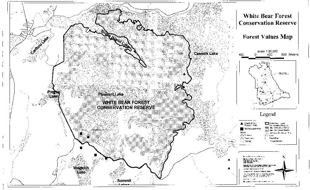
At a general landscape level, good diversity occurs with a minimum of 46 vegetation cover types distributed throughout the White Bear forest Conservation Reserve. Major cover types include white birch, eastern white pine, eastern white cedar and black spruce (see Forest Values Map). Small forest stands that occupy less than 20 ha include; jack pine/deciduous, sugar maple mixedwood, red pine/coniferous and poplar mixedwood. Old growth stands, especially northeast and southeast of Pleasant Lake and a variety of wetlands add to the diversity of the conservation reserve. Moderate plant species diversity was previously observed.
b) Condition:
The present condition of the conservation reserve is reflective of past and current trends of commercial, natural, and recreational disturbances. The conservation reserve has been affected by past commercial logging practices in Strathcona Township, the existing hydro transmission corridor that crosses the western part of the site and documented sporadic low intensity forest fire activity. There are a few canoe routes with portages in the northeast corner of the conservation reserve, with a campsite on the edge of Snake Island Lake. Many hiking, skiing and snowmobile trails pass through the conservation reserve. A forest access road and a rail line form the southern boundary. There are a few human disturbances outside the conservation reserve such as; seasonal residential development on patent land just north of Cassells Lake, a pipeline and an all-terrain vehicle (ATV) trail to the west.
c) Ecological factors:
The boundary of this conservation reserve was designed to use a number of features such as lake shorelines, creeks and human built structures (i.e., road and railway) which have helped to buffer it from adjacent land use over time. This design is also very effective in providing protection for the numerous wetlands located within the central portions of the conservation reserve.
d) Special features:
This conservation reserve contains a number of notable features, which possess varying degrees of significance. These features include:
- Sensitive wetlands and associated vegetation
- Provincially significant stands of old growth red pine, eastern white pine and eastern white cedar
e) Current land use activities:
A wide range of land use activities occur within, or are associated with the conservation reserve. Activities include the following: hunting, fur and baitfish harvesting, boating, canoeing, camping and trail use (e.g., non-motorized and motorized use).
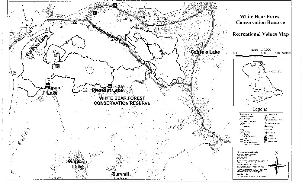
Hiking trails are a key feature of the conservation reserve and can be accessed at various entry points. From the west, the Caribou Mountain Lookout and Finlayson Point Provincial Park are primary points of access to the trails, while in the south there is an access trail departing from the Lowell Lake Road. Vehicle parking areas exist for these access points. The remaining access points, along the northern and eastern boundaries, are located on waterways, which can be reached by canoe or boat.
The trails meander through old growth red and white pine forests, provide scenic vistas of the surrounding landscape, and offer opportunities for wildlife viewing. Information and maps regarding use of these trails are available at the Visitors Center in the town of Temagami. There is evidence that hikers, mountain bikers, cross-country skiers, and snowshoers utilize these non-motorized trails. ATV and snowmobile travel have been noted on other trails that generally follow utility corridors and roads.
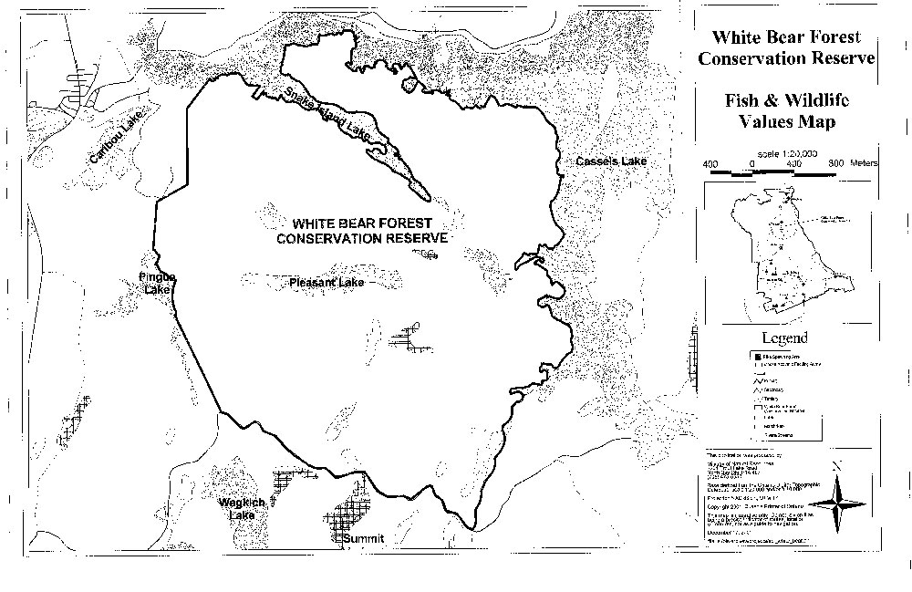
Pleasant Lake, a cold water system, provides angling opportunities for rainbow trout. Two Class 1 Moose Aquatic Feeding Areas are found in wetlands surrounded by cedar and white birch dominated forests in the central and southern portions of the conservation reserve.
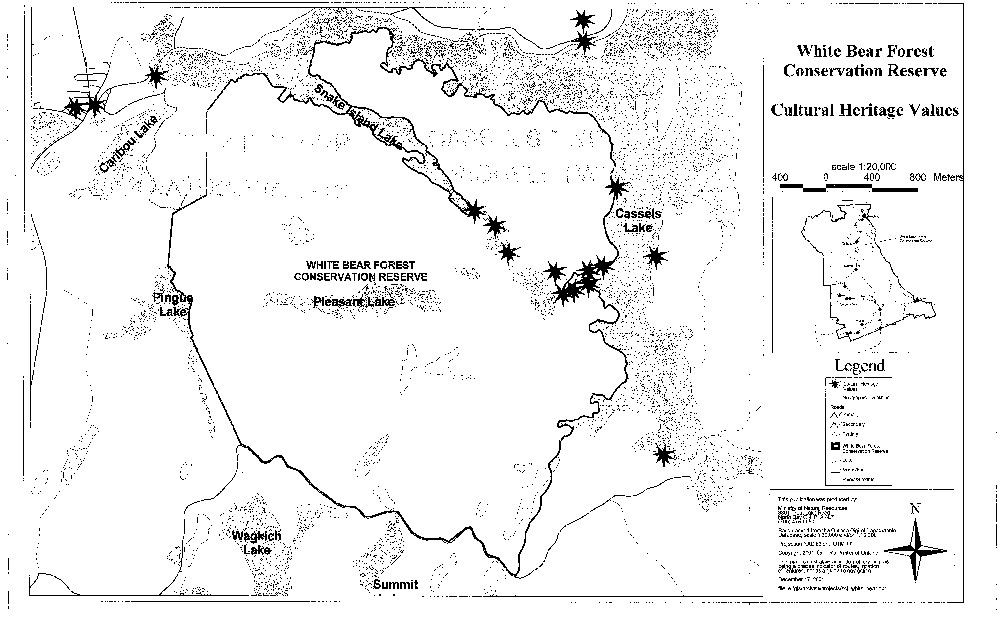
Traditional campsites and picnic areas are situated in the northeast and can be easily accessed by canoe or motor boat. An unmaintained portage traverses the conservation reserve from Snake Island Lake to Cassels Lake. This portage also provides access to Pleasant Lake. Archaeological evidence places the route to be in excess of 3000 years old with the Teme-Augama Anishnabai (TAA) having used it for centuries as a transportation and trade corridor (see Recreational Values Map).
Commercial uses such as fur and baitfish harvesting and moose and bear hunt outfitting occur in the conservation reserve. It is suspected that these activities are not intense and may have limited conflict with other interests. Recreational hunting is also permitted, with the primary game species being moose, bear and ruffed grouse.
Summary:
The White Bear Forest Conservation Reserve contains provincially significant old growth red and white pine communities and may contain significant wetland communities. The Gowganda land formation is well represented here, as it is at the end of its considerable exposure in Ontario. This is considered a regionally significant feature. The conservation reserve’s overall diversity, physical condition, design, and current and potential recreational and interpretive values are considered significant. Finally, the natural linkages connect the conservation reserve to the surrounding forested and aquatic landscapes found within the Temagami Region. This illustrates the conservation reserve importance to the provincial parks and protected areas system.
5.2 Social/Economic interest in the area
a) Linkage to local communities:
The White Bear Forest Conservation Reserve consists entirely of Crown land and is easily accessible to the public via road, rail or water. Located within the Municipality of Temagami, this conservation reserve is a popular destination for travelers and seasonal residents. As a result of the closure of the Sherman Mine and the Wm. Milne Sawmill in the early 1990s, tourism has become a major economic driver in the Temagami area, with scenic landscapes and the natural environment as major attractions.
The White Bear Forest Conservation Reserve is well suited for outdoor recreation, nature appreciation and educational opportunities. Its proximity to Cassels Lake and the town of Temagami, along with ease of access makes the conservation reserve a logical choice for a variety of back-country users. In a regional context, the conservation reserve offers natural features that generate interest in ecotourism, recreational and tourism markets.
Currently the conservation reserve is available for hunting, fishing, trapping, canoeing, hiking, camping, nature appreciation (i.e., viewing of old growth forests, wildlife observation, and photography), boating, cross-country skiing, snowshoeing, snowmobiling and ATV use.
The conservation reserve provides experiences and attractions for two adjacent land uses. Caribou Mountain located along the northwestern boundary is a high relief landform supporting an observation tower and viewing platforms. The Corporation of the Municipality of Temagami operates the site for scenic viewing opportunities. The White Bear Forest Conservation Reserve’s trail network provides a direct link permitting additional experiences for visitors wanting to observe old growth forests. Similarly, Finlayson Point Provincial Park located on Lake Temagami is a recreation class park that offers camping and dockage on the lake. It provides a hiking trail connection to both Caribou Mountain and the conservation reserve. This linkage contributes additional recreational opportunities for park visitors. Both facilities attract tourism to the area and provide benefit to the town’s economy (see Recreational Values Map).
There are several local outdoor recreational outfitting companies and resort lodges that may decide to expand their use of the White Bear Forest Conservation Reserve.
Outdoor education and scientific research potential in the conservation reserve is significant. The red and white pine old growth stands are excellent examples of a pristine forest which provide opportunities for viewing old trees, wildlife snags, regionally rare plant species, cathedral door fire scars and a succession community, to name a few. The need to develop the trail system’s interpretive potential is recognized.
b) Heritage estate contributions:
The White Bear Forest Conservation Reserve contributes to the province’s parks and protected areas system through its regulation, representation and the longterm management of its natural heritage values.
By allocating these lands to the parks and protected areas system through regulation, the province has ensured a certain level of permanence by distinguishing the conservation reserve and its values from the larger general use or more extensively managed landscape. In addition, its natural features are, and will be available for present and future generations to enjoy and explore.
The representation of the White Bear Forest Conservation Reserve’s values makes a number of contributions to the province’s natural heritage estate. Firstly, its old growth red and white pine communities and interior wetlands contribute significantly to the provincial parks and protected areas system. Secondly, the conservation reserve’s location, design and features make a distinctive contribution to quality recreational experiences that include hiking trails both within and adjacent to the site, scenic lookouts and rocky shorelines in addition to lakeshore landscapes. Thirdly, although rather small in size, traversed by a hydro corridor and affected by past logging disturbances, its circular shape and natural boundaries (e.g., shorelines) buffer adjacent land use activities and allow for a certain level of back-country opportunities and experiences. Finally its connection to Cassells Lake and regional canoe routes and waterways considerably adds to the over-all value of the conservation reserve.
Long term management must consider public access to the conservation reserve, its protection objectives, and commitments made in the Temagami Land Use Plan. Future managers will have to balance between maintaining the quality of the current natural features and the needs of recreational 'and other users.
c) Aboriginal groups
The White Bear Forest is within the ancestral homeland, known as Daki Menan, of the Teme-Augama Anishnabai (TAA). The forest is named after one of their Chiefs, Francois White Bear, who lived on Cassels Lake in the late 1800s. Approximately 150 members of the Teme-Augama Anishnabai and the Temagami First Nation (TFN) reside on the Bear Island Reserve, located on Lake Temagami. A number of pre-historic and historic archeological sites have been documented in the conservation reserve, particularly along the shoreline of Cassels Lake. These and other cultural heritage resources found within Daki Menan are of great importance to the Teme-Augama Anishnabai.
In 1999, Ontario agreed to enter into formal negotiations with the Temagami First Nation and the Teme-Augama Anishnabai on the basis of outstanding treaty obligations consistent with the Supreme Court of Canada’s 1991 Bear Island decision. These negotiations are scheduled to conclude in December 2002.
d) Mining industry:
All mining rights were withdrawn based on the boundaries established in the Temagami Land Use Plan prior to the lifting of the land caution. Minor boundary refinements were required primarily to define the site on the ground for regulation purposes. The mining rights were re-withdrawn in January 2001 to be consistent with the boundaries regulated in 1997.
e) Forest management
No commercial forest harvesting is permitted in conservation reserves. Forest activities on the adjacent landscape are guided by the Forest Management Plan (FMP). Based on the current plan (1999-2004), the following provisions apply:
Harvesting, renewal and maintenance are permitted up to the conservation reserve boundary. Where the integrity of the boundary may be affected by blowdown (e.g., based on slope, aspect relative to prevailing winds, soils, species, size and type of adjacent cuts, etc.) the need for additional protection is to be determined during the development and planning of the Annual Work Schedule.
No roads or landings are permitted within 100 m of the boundaries of nonwaterway conservation reserves, except where it can be demonstrated no alternative alignments are available and with MNR approval. Roads will be planned to minimize potential access to conservation reserves (e.g., perpendicular to conservation reserve boundaries).
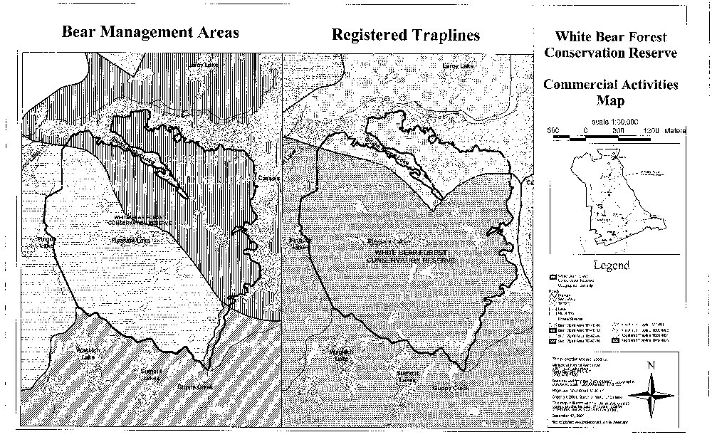
Presently there is no Sustainable Forestry License (SFL) within or adjacent to the conservation reserve. The Crown currently manages the Temagami Forest Management Unit. The North Bay District office (Temagami Area) administers Forest Resource Licensing (FRL) in this unit.
f) Utilities
There is a hydroelectric power transmission corridor, which runs in a north-south direction through the conservation reserve.
5.3 Natural Heritage Stewardship
Preliminary analysis of the life science targets based on landform/vegetation combinations have shown that the conservation reserve contains 8 such combinations, (perhaps up to 46) dominated by dense coniferous forest over weakly-broken ground moraine (OFRI, 1994) (see Forest Values Map). The most significant features include the old growth stands of red and white pine, sensitive wetlands, and additional old growth white cedar and white birch stands. In addition, bedrock exposures are considered to be regionally significant.
A recent aerial reconnaissance survey showed no wide spread forest disturbance due to forest harvesting, fire, insect, wind throw, wildlife damage, ice storms or other natural disturbances.
The MNR maintains three permanent sample plots in the conservation reserve: two Forest Ecosystem Classification plots and one Growth and Yield plot (see Forest Values Map).
As noted earlier, the conservation reserve drains into two different watersheds: the French and Ottawa Rivers. Cassels and Snake Island Lake shorelines dominate the eastern and northern boundary of the conservation reserve, while Pingue Lake’s shoreline and a number of small creeks form portions of the Statement of Conservation Interest remaining natural boundaries. Pleasant Lake is situated in the interior of the conservation reserve.
Water levels on Cassels and Snake Island Lakes are controlled by Hydro One and fluctuate significantly throughout the year.
5.4 Fisheries and wildlife
There have been no detailed wildlife studies undertaken within the conservation reserve, with the exception of some values monitoring. The importance of the conservation reserve to wildlife species has yet to be determined, particularly for those species, and habitats thereof, that may be vulnerable, threatened or endangered. Aquatic habitat inventories on some peripheral lakes have been performed. These include Cassels and Snake Island Lakes.
Should any vulnerable, threatened or endangered (VTE) wildlife and or plant species be identified within or adjacent to the conservation reserve their value will be protected. Although the species may be identified as residing within the site, their location will remain undisclosed.
Caribou Mountain was the site of a peregrine falcon release (40 chicks) in the early 1990s; however, there are no known peregrines residing in the conservation reserve.
Several Class 1 Moose Aquatic Feeding Areas are found in wetlands surrounded by cedar and white birch dominated forests in the central and southern portions of the conservation reserve. These areas have the potential to supply aquatic plants for moose during the summer months (see Fish & Wildlife Values Map).
The conservation reserve and adjacent landscapes maintain both cold and warm water fisheries. Cassels and Snake Island Lakes support a wide variety of species such as lake trout, walleye and smallmouth bass. The rainbow trout fishery in Pleasant Lake is maintained via stocking and provides a unique angling experience for the area. The Community Fisheries and Wildlife Improvement Program (CFWIP) release walleye fingerlings in Snake Island Lake.
The aquatic habitats of all interior water bodies, other than Pleasant Lake are unsurveyed.
5.5 Cultural Heritage Stewardship
There are 10 documented and registered sites (MCzCR) linked to historical travel routes and habitation in the White Bear Forest Conservation Reserve. Areas of high potential cultural heritage have been mapped through a predictive Statement of Conservation Interest modeling process. These areas are linked to shorelines and known historic travel routes (see Cultural Heritage Values Map).
5.6 Use/existing development
The Highway 11 corridor is located between the Northeast Arm of Lake Temagami and west of the western boundary of the conservation reserve. This is the major access artery to this area. Crown land recreation is very prevalent in this region. Lake Temagami supports numerous summer homes and a wide range of recreational opportunities and is also a focal point for other backcountry destinations and experiences.
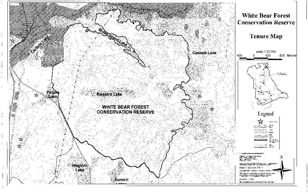
Permanent and seasonal dwellings are found on patent parcels along Highway 11, the north shore of Cassels Lake and in the town of Temagami itself. The conservation reserve’s boundaries exclude four private lots: one located on Snake Island Lake and three on Cassels Lake (see Tenure Map).
Mining claims and leases do not exist within the conservation reserve, but do exist in the surrounding area. Utility corridors for rail and hydro transmission border on or pass through the conservation reserve. The hydro transmission corridor is held under a Land Use Permit and requires routine maintenance. The rail line, that forms part of the western boundary, is owned by Ontario Northland Railway and also requires periodic maintenance work.
There is no other form of tenure in the conservation reserve other than legal agreements with registered fur trappers, bear management area operators and baitfish licensees.
Traditional uses within the conservation reserve will continue to be permitted; however, the goal will be to resolve conflicts regarding incompatibility between uses and to ensure that identified values are adequately protected. Existing uses are as defined in Section 5.2 a).
Non-motorized trails (i.e., hiking, cross-country skiing) are the only new developments in the conservation reserve in recent years. These trails are generally found in areas of old growth forest.
5.7 Commercial use
Present commercial use activities are illustrated on the Commercial Activities Map. Two fur traplines (one registered and one First Nation Co-operative) and three Bear Management Areas (BMAs) overlap the conservation reserve. Guided hunting for other species (i.e., moose) provides economic benefit to commercial hunting outfitters as well. Commercial baitfish harvesting is licensed on a Statement of Conservation Interest township basis; however, the northwest corner of the conservation reserve within Strathy Township is not available for this activity.
5.8 Tourism/recreation use/opportunities
Current uses of this conservation reserve have been described in Section 5.1(e). Presently, there is no known infrastructure supporting any recreational or commercial activity within the conservation reserve’s boundaries.
The Corporation of the Municipality of Temagami and the MNR/Ontario Parks Temagami Area, has identified specific interests for the conservation reserve. These interests relate to preserving the natural and social aspects of the site while providing ecotourism and employment type opportunities. Of primary importance, is the conservation reserve’s linkage with the local trail system that connects Finlayson Point Provincial Park, the town of Temagami and other local areas. This trail network promotes and highlights the recreational use and potential of the White Bear Forest Conservation Reserve and associated landscapes.
During the planning phase for the conservation reserve, no new recreational, ecotourism or tourism initiatives were brought forward for consideration.
5.9 Client services
Presently, client services include district responses to public inquiries. No formal information or interpretive facilities currently exist within the conservation reserve.
6.0 Management guidelines
6.1 Management planning strategies
Commitments identified in previous planning documents ( TLUP and current policy (Policy 3.03.05 PLA)) will form the basis for land use decisions within the conservation reserve. Management strategies for these uses must consider the short and long-term objectives for the reserve. For current information on permitted uses, refer to the Crown Land Use Atlas.
Proposed uses and development will be reviewed on a case-by-case basis. A Test of Compatibility, (Procedural Guideline B - Land Uses (PL 3.03.05)) must be passed before they are deemed acceptable. The emphasis will be on ensuring that the natural values of the conservation reserve are not negatively affected by current and future activities. Therefore, any application for new Statement of Conservation Interest specific uses will be carefully studied and reviewed. The Ministry, partner organizations and/or proponents may undertake such studies.
6.2 State of the resource management strategies
The development of this SCI and the long term management and protection of White Bear Forest Conservation Reserve will be under the direction of the MNR's North Bay District, Temagami Area Supervisor. The following management strategies have been created to achieve the goals and objectives stated earlier in this management document:
Social/Economic
- Management direction will aim to maintain and develop social and economic benefits to the local communities where practical
- Local partnerships may be solicited in the delivery of certain objectives identified in this SCI
- Educational opportunities will be developed and encouraged in order to create an awareness of natural systems in the Temagami area
Natural Heritage Stewardship
- With the exceptions of fire suppression and forest infestation control, the management intent for the White Bear Forest Conservation Reserve is to allow for natural ecosystems, processes and features to operate undisturbed with minimal human interference while providing educational, research and recreational activities
- Forest ecosystem renewal and maintenance as stated for this conservation reserve under the TLUP will only be entertained via a separate vegetative management plan
- All wildfire occurrences will be considered a high priority and will actively be suppressed until such time as policy directions change
- Prescribed burning will be conducted only under the direction of the provincial fire strategy and authorized for the conservation reserve under a separate vegetative management plan. Prescribed burning may be utilized if deemed necessary to emulate natural disturbances and renew forest communities, prepare seed beds for research and/or education purposes or to meet additional objectives determined within a separate vegetative management plan
- All earth and life science features will be protected by defining compatible uses, enforcing regulations and monitoring and mitigating issues
- Industrial activities such as; commercial timber harvest, prospecting and mining and new hydro generation will not be permitted within the conservation reserve
- Permits for fuel-wood will not be issued
- New energy transmission, communication and transportation corridors or resource roads or construction of facilities are discouraged within the boundaries of the conservation reserve
- Other activities that do not pass a Test of Compatibility will be prohibited (MNR Policy 3.03.05, 1997)
- The introduction of exotic and/or invasive species will not be permitted
- Programs may be developed to control forest insects and diseases where there is a concern that significant values may be compromised. Remedies must focus on the outbreak or infestation. Biological or non-intrusive solutions should be applied whenever possible. Vegetation maintenance of the existing utility corridor should be encouraged to follow this process where and when feasible
- The collection/removal of vegetation and parts thereof will not be permitted; however, subject to a Test of Compatibility, the Area Supervisor may authorize the collection of plants and/or parts for purposes of rehabilitating degraded sites within the conservation reserve or maintaining genetic stock and/or research
- Detailed ecological surveys concerning ground vegetation and additional plant values assessment - especially concerning species at risk is warranted. Additional plant science inventory should be linked to future recreational needs and possibly regional gap analysis approaches. Assessments should follow future direction and methods established through MNR's Inventory, Monitoring and Assessment Reporting (IMAR) program (see section 6.4)
- MNR will provide leadership and direction for maintaining the integrity of this conservation reserve as a heritage estate
- Research, education and interpretation will be encouraged to provide a better understanding of the management and protection of the natural heritage values and will be fostered through local and regional natural heritage programs, initiatives and partnerships
Fisheries and Wildlife
- Fish and wildlife resources will continue to be managed in accordance with policies and regulations prevailing in the area and under the direction of the Temagami Area Supervisor. Provincial legislation and policy will dictate management and enforcement objectives for this area
- Management direction will aim to verify species present, ecological function and habitat requirements
- Additional fish and wildlife population and habitat assessments, especially for species at risk, are warranted
- Any fish and wildlife inventory may require a regional gap analysis approach
- Inventories, assessments or monitoring programs should follow direction and methods established through MNR's IMAR program and be linked to district sustainability objectives and initiatives or future recreational needs. (see section 6.4)
- Moose aquatic areas should be resurveyed to update data
- Fish stocking and aquatic habitat assessment of Pleasant, Pingue and other unnamed lakes should be considered in future district assessment initiatives
- Hunting and angling will be permitted within this conservation reserve
- First Nation Treaty rights will be respected (see Aboriginal Interests)
- Pleasant Lake will be managed as a rainbow trout fishery
- Area of Concern (AOC) prescriptions for the protection of fish and wildlife values, developed for forest management purposes, will be used as a guide when considering proposed activities/developments in the conservation reserve
- The rehabilitation of damaged ecosystems will occur whenever possible (maintain bio-diversity).
Cultural Heritage
- Protection of these values will be maintained
- Documented sites will be checked periodically for signs of degradation. Additional sites will be documented as encountered
- Development, research and education proposals may be considered in accordance with the Test of Compatibility; Conserving a Future for our Past: Archaeology, Land Use Planning & Development in Ontario, Section 3 (MCzCR, 1997) and MNR's AOC Descriptions and Prescriptions (Cultural Heritage Resources) for the 1999-2019 Temagami FMP or its successor
- Research/education to provide a better understanding of the management and protection of cultural heritage values will be encouraged
Land Use/Existing Development
- Existing land uses and development within the conservation reserve that conflict with the protection objectives (Test of Compatibility) will be identified and discontinued if impacts can't be mitigated. Similarly, uses in adjacent lands will be reviewed. If they are found to impact on the conservation reserve, mitigation measures will be explored
- There will be no new motorized trail development; however, non-motorized trail development may be permitted only if the activity passes a Test of Compatibility
Commercial Use
- Existing commercial uses such as fur and baitfish harvesting and the operation of bear management areas will be permitted. Such activities will continue to be monitored in order to ensure they do not unduly deplete natural resources and that they impose a minimal impact on the features identified for protection
- Trapline cabins will not be permitted
- Commercial enterprises offering ecotourism experiences will be encouraged, providing these activities are low in intensity and are compatible with other uses
Aboriginal Interests
- Aboriginal and treaty rights will continue to be respected throughout the management of this SCI. Any future proposal(s) and or decision(s) that have potential impact(s) on individual aboriginal values and or communities will involve additional consultation with the affected aboriginal groups
Tourism/Recreation
- The earth and life science features and their protection, shall be the overall theme for tourism
- The conservation reserve should also be portrayed as providing backcountry experiences near an urban setting
- Compatible linkages between Caribou Mountain and Finlayson Point Provincial Park will be explored and encouraged
- Small-scale infrastructures for enhancing tourism and recreation (i.e., warmup shelter) may be considered, providing they pass a Test of Compatibility and other review requirements
- Main base tourism development (lodges) will not be permitted
- Conflict resolution between recreational uses will be a priority. This will be achieved by adhering to the objectives of this SCI with input from relevant user groups
- The level of safety and compatibility between activities will determine permitted uses (i.e., Test of Compatibility)
- Low-impact camping may be permitted along the waterways
- Degradation of cultural heritage sites will not be permitted and current and future use will be monitored and if deemed necessary, camping may be prohibited at certain sites in order to protect these values
Client Services
- Information regarding the White Bear Forest Conservation Reserve may be delivered from different sources, however MNR will be the lead agency for responding to inquiries regarding access, land use, values and recreation opportunities
- A management agreement may be pursued with an appropriate partner to share responsibilities for information services and the delivery of other aspects of this Statement of Conservation Interest
6.3 Specific feature/area/zone management strategies
Presently there are no specific management strategies in place for sub-zones within the conservation reserve.
With the exception of fire suppression, the old growth pine ecosystem located in the northern section of the conservation reserve will be allowed to develop in a natural, undisturbed manner. Any change in management direction for the old growth areas will be addressed within a vegetation management plan.
If, during the course of conservation reserve monitoring it is deemed necessary to regulate access or uses in certain areas, management zones may be developed. These zones will facilitate permitted/restricted activities for the protection of certain features or to resolve conflicts between uses. Zone management will endeavor to compliment linkages to areas and uses outside the conservation reserve. The creation of management zones will require additional planning beyond this SCI, public consultation and an eventual plan amendment if accepted.
6.4 Promote Inventory, Monitoring and Assessment Reporting (IMAR), and research
There are many opportunities to study and explore the natural systems in the conservation reserve. Since there has been little interference from "outside influences", some features may be observed in a relatively undisturbed state.
The MNR maintains two Forest Ecosystem Classification plots and one Growth and Yield plot (see Forest Values Map). The establishment of these permanent sample plots was based on their representation within the site region/district. These plots are monitored on an on-going basis and provide valuable Statement of Conservation Interest information regarding plant ecology and forest growth characteristics. This benchmarked information provides trend through time data that managers may use to identify and predict the effect of management strategies on similar landscapes. These types of plots exist throughout the province and to some extent, throughout the world.
The compatibility of current and future sample plots will be reviewed to ensure they conform with the protection of values and are unobtrusive to other activities conducted within the conservation reserve. Non-destructive research will be promoted as an asset for procuring an understanding of the natural features and processes in the White Bear Forest Conservation Reserve.
New recreational developments such as campsites, privies, trails or developed access points will not be considered until a Test of Compatibility is conducted. The Test of Compatibility or environmental screening process could include a review of the demand for structures or may require more detailed life or earth science or cultural information and possibly a more detailed management plan.
6.5 Implementation and plan review strategies
This Statement of Conservation Interest will be reviewed on an ongoing basis. Implementation of the SCI will include monitoring activities to ensure adherence to management guidelines. A full review will coincide with the review of the Temagami Land Use Plan (next review - 2006) and will be done every ten years thereafter.
Implementation of the SCI and management of the conservation reserve are the responsibility of the Temagami Area Supervisor. Partnerships may be pursued to address management needs. If changes in management direction are needed at any time, the significance of the changes will be evaluated. Minor changes, which do not alter the overall intent of this SCI, may be considered and approved by the District Manager without further public consultation and the SCI will be amended accordingly.
In assessing major changes, the need for a more detailed resource management plan (RMP) will first be considered. Where a RMP is not considered necessary or feasible, a major amendment may be considered with public consultation. Such amendments will also be posted on the Environmental Bill of Rights (EBR) registry. The Regional Director has approval authority for any major amendments for this SCI.
6.6 Marketing strategies
Messages should focus on the conservation reserve’s accessibility, natural heritage representation, recreation opportunities and the ''Temagami Statement of Conservation Interest Experience" in general. Finlayson Point Provincial Park and the Corporation of the Municipality of Temagami stand to benefit from the conservation reserve if marketed properly and according to its intended uses. Research and education is a theme that should be incorporated in all promotional strategies. Any future development of the trail system will include an interpretive trail' and guide.
Partnerships may be fostered to aid in the delivery of this component.
References
Crins, W.J. and P.W.C. Uhlig. 2000. Ecoregions of Ontario: Modifications to Angus Hills' Site Region and Districts- Revisions and Rationale.
Hills, G.A. 1959. A Ready Reference to the Description of the Land of Ontario and its Productivity. Ontario Department of Lands and Forests, Division of Research, Maple, Ontario. 140pp.
Kor, P.S.G. 2001. Earth Science Checksheet: White Bear Forest Conservation Reserve.
Ontario Ministry of Citizenship, Culture and Recreation. 1997. Conserving a Future for Our Past: Archaeology, Land Use Planning and Development in Ontario. 42pp.
Ontario Ministry of Natural Resources. 2001. A Draft Environmental Assessment for MNR Resource Stewardship and Facility Development Projects. 76pp.
Ontario Ministry of Natural Resources. 1999. Forest Resource Inventory (FRI) Mapping: White Bear Forest Conservation Reserve. Ontario Ministry of Natural Resources, North Bay.
Ontario Ministry of Natural Resources. 1997. Public Lands Directive Manual: Natural Heritage- PL 3.03.05.
Ontario. Ministry of Natural Resources. 1997. Temagami Land Use Plan for the Temagami Comprehensive Planning Area.
Ontario. Ministry of Natural Resources. 1991. Temagami Comprehensive Planning Program (Heritage Component)- Preliminary Review of Heritage Resources.
Ontario. Ministry of Natural Resources. 1987. Assessment of Representative and Special Earth Science Resource Features of the Temagami Planning Area. Volume 2.
Hewitson, S. 2001. Recreational Inventory Checksheet: White Bear Forest Conservation Reserve.
Rowe, J.S. 1977. Forest Regions of Canada. Canadian Forest Service Publication No. 1300. 171pp.
Thompson, J.E. 2000. Aerial Reconnaissance Survey: White Bear Forest Conservation Reserve.
Thompson,I.E., M. Lajeunesse, J. Joyce and N. Avoledo. 2001. Life Science Checksheet: White Bear Forest Conservation Reserve.
Appendix A
Procedural Guideline B - Land Uses - Test of Compatibility
Public Lands Act Policy PL 3.03.05 (procedure 3.03.05)
The Conservation Reserve policy provides broad direction with regard to the permitted uses. The policy provides only an indication of the variety of uses that will be considered acceptable in Conservation Reserves. The only caution is that "any new uses, and commercial activities associated with them will be considered on a case by case basis; they must pass a test of compatibility to be acceptable". What does a "test of compatibility" mean?
An examination of this must start from the premise of why an area is set aside - specifically, its representative natural heritage values. Criteria are then identified to guide compatibility considerations. These criteria apply to the long-term acceptability of both existing uses and new uses.
-
Conformity to SCI: SCI describe values for which an area has been set aside and the range of appropriate uses that will be permitted in the area. SCI may also speak to the acceptability of other "new" uses currently not occurring in the area.
The first "test" is: "do proposed new land uses and/or commercial activities conform to the direction of the SCI for the Conservation Reserve? Would the new use(s) depart from the spirit of appropriate indicator land uses in the SCI?"
- Impact Assessment: If the proposed use(s) pass test one it is important to determine their impact on the area before they are approved. This should include the following:
- Impact on natural heritage values: "will the new use(s) impact any natural values in the area? If so, how and to what degree? Is it tolerable?"
- Impact on cultural values: "will the new use(s) impact any historical or archaeological values in the area?"
- Impact on research activities: "will the new use(s) affect any research activities in the area?"
- Impact on current uses: "will the new use(s) have any negative impact on the array of current uses?"
- Impact on area administration: "will the new use(s) increase administrative costs and/or complexity?" (For example, the cost of area monitoring, security and enforcement).
- Impact of accommodating the use outside the Conservation Reserve: "Could the use(s) be accommodated as well or better outside the Conservation Reserve?"
- Impact on socio-economics of the area: "will the use(s) affect the community(ies) surrounding the area in a positive or negative way?" (for example, will the new use make the area less remote thereby affecting a local tourism industry that is dependant on the area for its appeal)?
- Impact on area accessibility: "does the new use(s) give someone exclusive rights to the area or a portion of the area to the exclusion of other existing uses?"
Appendix B
Glossary of terms
Annual Work Schedule: one-year schedule of forestry operations (i.e. harvest, renewal, tending, road planning etc.)
Class 1 Moose Aquatic Feeding Areas: are those wetland areas that have minimal wildlife habitat potential for this species.
Ecotourism: responsible tourism that considers the natural heritage values within the conservation reserve and their sustainability as well as taking into account the interests of local communities.
Fen: peatland with water table at or above the surface with very slow water movement through communities via seepage that results in a more mineral, nutrient and oxygen-rich environment than bogs. Generally fens contain peat accumulations greater than 40 cm deep. Sometimes floating mat with sedges, mosses, shrubs and sparse tree layer present. Indicator plants include; Larch (Larix laricina) and Eastern White Cedar (Thuja occidentalis) over Black Spruce (Picea mariana) , Speckled Alder (Alnus incana), Dwarf Birch (Betula pumila) , Bluejoint Grass (Calamagrostis canadensis), assorted sedges, Sweet Gale (Myrica gale) with ericaceous shrubs present- especially in more nutrient poor fens (Harris et al. 1996).
Poor fen wetlands generally contain greater amounts of black spruce than cedar and larch as well as ericaceous shrubs and sphagnum or peat mosses.
IMAR: An integrated, ministry-wide framework for Inventory, Monitoring, Assessment,and Reporting that supports the management of our natural resources in an ecologically sustainable way.
Land Caution: registered on 110 townships in the Temagami area in August of 1973, which prevented first registration of tenure documents by the Crown. The documents included patents, leases, and easements. A court ruling in 1996 ended the caution.
Meadow marsh: wetlands that are seasonally flooded and are associated with lakes or river s or have pools of water greater than 25 percent. Emergent vegetation is generally greater than 80% with the edge of the wetland not clearly demarcated from open water.
Thicket Swamp: areas of willow (Salix spp.) or speckled alder (Alnus incama) which typically have tall shrub cover greater than 25% and are found along shorelines, edges of beaver meadows and stream floodplains. Seasonally flooded areas.
Maps
Map 1: White Bear Forest Conservation Reserve Location Map
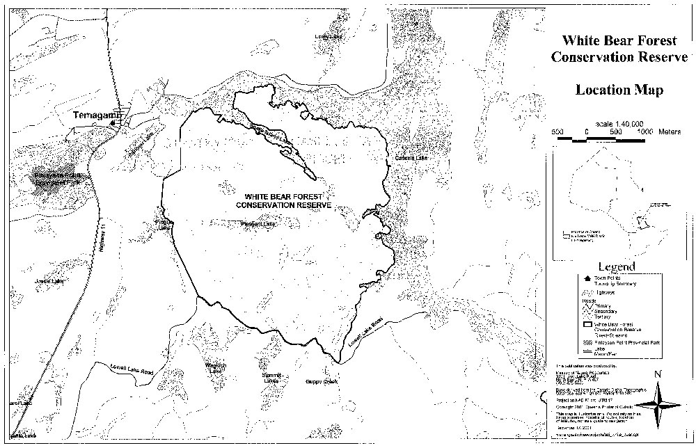
Enlarge Map 1: White Bear Forest Conservation Reserve Location Map
Map 2: White Bear Forest Conservation Reserve Forest Values Map
Enlarge Map 2: White Bear Forest Conservation Reserve Forest Values Map
Map 3: White Bear Forest Conservation Reserve Recreational Values Map
Enlarge Map 3: White Bear Forest Conservation Reserve Recreational Values Map
Map 4: White Bear Forest Conservation Reserve Fish and Widlife Values Map
Enlarge Map 4: White Bear Forest Conservation Reserve Fish and Widlife Values Map
Map 5: White Bear Forest Conservation Reserve Cultural Heritage Values
Enlarge Map 5: White Bear Forest Conservation Reserve Cultural Heritage Values
Map 6: White Bear Forest Conservation Reserve Commercial Activities
Enlarge Map 6: White Bear Forest Conservation Reserve Commercial Activities
Map 7: White Bear Forest Conservation Reserve Tenure Map
Enlarge Map 7: White Bear Forest Conservation Reserve Tenure Map
Footnotes
- footnote[1] Back to paragraph A.G. Harris, S.C. McMurray, P.W.C. Uhlig, J.K. Jeglum, R.F. Foster and G.D. Racey. 1996. Field Guide to the wetland ecosystem classification for northwestern Ontario. Ont. Min. Natur. Resour., Northwest Sci & Technol. Thunder Bay, Ont. Field Guide FG-01. 74pp. +Append.