White Lake Provincial Park Management Plan: Amendment
This document provides amended policy direction for the protection, development and management of White Lake Provincial Park and its resources.
Parks Management Plan - Minor Amendment
2007
Approval statement
I am pleased to approve this Minor Amendment to the White Lake Provincial Park Management Plan. This minor amendment is a statement of policy update to the original management plan (1987).
This minor amendment is based on the direction in Ontario’s Living Legacy Land Use Strategy (OMNR 1999) to add lands identified as the White Lake Addition (P1506) to White Lake Provincial Park. The original park management plan and this minor amendment address policies for resource stewardship, operations and development of all lands and waters now regulated as part of White Lake Provincial Park (O. Reg. 331/06).
The original management plan and this minor amendment provide guidance for resource stewardship, operations and development within White Lake Provincial Park that is consistent with Ontario Parks policies and objectives.
Signed by:
Paul Bewick
Zone Manager
Northeast Zone
Ontario Parks
Date: March 7, 2007
1.0 Introduction
White Lake Park Addition was designated in Ontario’s Living Legacy Land Use Strategy to be added to the original White Lake Provincial Park (OMNR 1999). The original park and the White Lake Addition were combined and regulated in June of 2006 under the Provincial Parks Act to encompass 4,048 hectares (O. Reg. 331/06). The Ontario Living Legacy Land Use Strategy and the subsequent regulation under the Provincial Parks Act identified the White Lake Park Addition and the original White Lake Provincial Park as a natural environment class park.
The White Lake Park Addition includes the section of the White River from the boundary of the original White Lake Provincial Park to Pukaskwa National Park, a linear distance of approximately 55 kilometres. The upstream end is approximately 60 kilometres east of the town of Marathon and 30 kilometres west of White River.
The White Lake Park Addition offers recreational canoeing opportunities along a recognized and popular canoe route (Kershaw, 2002). It follows an ancient travelway used by Aboriginal people and recorded in 1827 as the "Wabista or White River- navigable for small canoes" (The Society for the Diffusion of Useful Knowledge 1827).
1.1 Objectives
White Lake Park Addition will be managed according to the four objectives for provincial parks:
Protection: To protect provincially significant elements of the natural and cultural landscapes of Ontario.
Recreation: To provide provincial park outdoor recreation opportunities ranging from high intensity day-use to low-intensity wilderness experiences.
Heritage Appreciation: To provide opportunities for exploration and appreciation of the outdoor natural and cultural heritage of Ontario.
Tourism: To provide Ontario’s residents and out-of-province visitors with opportunities to discover and experience the distinctive regions of the Province.
2.0 Management context
Ontario’s Living Legacy Land Use Strategy identified these additions to the existing White Lake Provincial Park. The Strategy changed some of the policies for existing provincial. parks as well as introducing some different management policies for new protected areas. Also as an exception to only the White Lake Park Addition of all the new parks and park additions, there is a provision for hydro activity as a non-conforming use (OMNR 1999). These changes to policy are reflected in this minor amendment.
The purpose of this Minor Amendment is to provide direction to ensure custodial management of park Addition until future planning is undertaken, which includes Aboriginal dialogue and public consultation. At that time, significant decisions regarding resource stewardship, operations, development and permitted uses will be made.
Park management will follow policy direction from:
- Ontario’s Living Legacy Land Use Strategy (OMNR 1999), policy clarification amendments (OMNR 2000) and related direction
- Ontario Provincial Parks Planning and Management Policies (OMNR 1992) and updates
- Ontario Crown Land Use Policy Atlas (OMNR 2004), and amendments, and the
- Provincial Parks Act RSO (OMNR 1990) and regulations
Custodial management will protect values and ensure public health and safety in the park Addition. Ontario Parks will ensure that policy and environmental assessment requirements are implemented.
Figure 1: Regional Setting
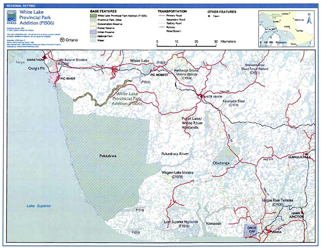
Enlarge figure 1: Regional Setting
Figure 2: Park Boundary
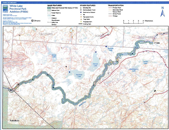
Enlarge figure 2: Park Boundary
2.1 Environmental Assessment
As part of the Ontario Ministry of Natural Resources, Ontario Parks is a public sector agency that is subject to the Environmental Assessment Act. Management of this natural environment park addition will be carried out in accordance with legislation, policies and guidelines that are required under the Class Environmental Assessment for Provincial Parks and Conservation Reserves (OMNR 2005).
3.0 Park features and values
Most of the park Addition occurs on strongly broken shallow sandy till uplands. Small representations of glaciofluvial and glaciolacustrine features occur within the site. This site contains representations of boreal forests, both smooth and turbulent flowing water, as well as abandoned oxbows and small river wetlands (Morris, 2001).
3.1 Geological features
Bedrock Geology consists of an undifferentiated, foliated to gneissic, tonalite suite of intrusive rocks which is well exposed along the length of the river in shoreline outcrops and cliffs. In Brothers Twp, bedrock consists of mafic to felsic metavolcanics and metasedimentary sequences (Kor, 2003). This rock has been assigned to the Pukaskwa Gneissic Complex, and lies in the Wawa Subprovince, Superior Province, Canadian Precambrian Shield (Kor, 2003).
Surficial Geology includes sand, silt, clay and minor boulder lags and unconsolidated bluffs, with occasional oxbows and meanders along the lower course of the river. The lower part of the river may have been instrumental in channelling glacial meltwaters off the Shield into the Superior basin, and may have been occupied by the upper reaches of glacial Lake Minong in early postglacial time (Kor, 2003).
The waterway includes that portion of the White River from the existing White Lake Provincial Park to Pukaskwa National Park- 55 kilometres. There’s a 90 metre drop in elevation in the portion of river within the White Lake Park Addition, falling an average of four metres every kilometre.
Rock outcrops are found intermittently in the park Addition. Sections that have bedrock controlled channel characteristics are prominent due to white-water that appears as swifts, rapids and falls. Swifts or chutes occur where the river surges through a bedrock constriction to create fast moving water without surface disturbance. Rapids occur where flows are obstructed by boulder deposit or by more resistant bedrock in the channel bottom that breaks the surface flow to create white water sections (Kershaw, 2002).
3.2 Biological features
This park Addition extends south along the White River providing linkage of the original park with Paukaskwa National Park. The dominant landform vegetation type that is represented here is lacustrine deposit With the minimum waterway park boundary of 200 metres there is incomplete and fragmented inclusion of upland forest types, with boreal forest that has high concentrations of conifer, especially near the Lark Superior coast. Other areas along the river contain sections of poplar, mixed deciduous and mixed deciduous/coniferous forest. In total, over 16 landform vegetation combinations are represented here. Unlike most of the interior waters in this area, the White River contains a diversity of fish species. This includes one of the few healthy walleye populations in the area (Morris, 2001).
3.3 Cultural setting
A detailed survey and analysis of the cultural history and features of the White Lake Park Addition has not been completed at this time.
Future planning will use a provincial framework, The Topical Organization of Ontario History (OMNR 1974) and updates and discussions with other agencies, Aboriginal communities and interest groups to identify cultural heritage values and features and their significance within White Lake Provincial Parks Addition. This information may be used to develop management guidelines to conserve and protect representative archaeological and historical values and features, as well as provide direction for further research.
3.4 Recreation
The 55 kilometres of the White River through the park Addition is navigable, albeit there are portages around the several rapids and falls. Great potential exists for backcountry canoeing and waterway recreation with the use of canoe/kayak routes steadily rising (Kenerknecht, 2000). 'The White River is for advanced paddlers only. Portages are difficult." (http:/www.myccr.com/canoedb/routeDetails.php?routeid=243) [link is no longer active].
The original river within the Addition included 20 sections of rapids and four falls and the White Lake Dam at the time of writing this management direction. Rapids can vary in the degree of whitewater and portages can be lengthy and rugged depending on topography, water levels, weather and experience of paddlers.
White River Canoe Route descriptions can be found in leaflets, books, on web sites and files. Collectively the descriptions are quite detailed providing accurate locations of swifts, rapids and falls and portages as wen as distances for portages with notes on changes due to seasonal water levels. Persons travelling the White River typically go all the way to Superior adding a further 14 kilometres within Pukaskwa National Park. As mentioned earlier in this document hunting and fishing opportunities exist as wen as there is potential for wildlife viewing within the White River Park Addition (Kershaw, 2002). Of particular interest on this waterway is the potential to view Caribou.
4.0 Aboriginal uses
The White Lake Park Addition is located in the Robinson- Superior Treaty of 1850. The closest Aboriginal community is Pic Mobert First Nation. The Pic Heron Bay First Nation, on the Pic River west of Pukaskwa also includes the White River in their territory.
Existing Aboriginal, treaty and/or constitutional rights can continue to be exercised within the White Lake Provincial Park Addition. Ontario Parks intends to communicate and work with Aboriginal communities during future planning and management of the park.
Any communications and cooperation between Aboriginal communities and the MNR for planning and operations purposes will be done without prejudice to any future discussions or negotiations between the Government of Ontario and Aboriginal communities.
5.0 Stewardship policies
5.1 Terrestrial ecosystems
Removal, damaging or defacing of Crown properties, natural objects, relics and artifacts is not permitted in provincial parks (Provincial Parks Act RSO 1990).
Non-native species will not be deliberately introduced into the park Addition. Where non-native species are already established and threaten values (i.e., has become invasive), a strategy to control the species may be developed (OMNR 1992).
5.1.1 Vegetation
Harvesting
Commercial forest operations are not permitted within the boundaries of the park Addition (OMNR 2004).
The commercial harvesting of other non-timber forest products (i.e., Canada yew, wild rice, etc.) will not be permitted within the boundary of the White Lake Park Addition (OMNR 2004).
In the White Lake Park Addition there are no authorized fuel wood cutting permits and as indicated by the amended Ontario Provincial Park Policy, no new permits will be issued (OMNR 2000).
Insects and disease
Insects and diseases may be managed where the aesthetic, cultural, and/or natural values of the White Lake Park Addition are threatened (OMNR 1992).
Controls will follow guidelines established by the Ontario Ministry of the Environment and the MNR. Biological control, rather than chemicals will be used whenever possible (OMNR 1992).
Fire
Fire management in Ontario is based upon a division of the Province by management objectives, land use, fire load, and forest ecology (OMNR 2002a). White Lake Park Addition is located within the Boreal Fire Management Zone. In accordance with existing provincial park policy and the Forest Fire Management Strategy for Ontario, forest fire protection will be carried out in the White Lake Provincial Park Addition as on surrounding lands (OMNR 2002).
Whenever feasible, the MNR Fire Program will use techniques which do not cause undue damage to the landscape (i.e., limiting the use of heavy equipment and/or limiting the number of trees felled during response efforts) (OMNR 2002).
5.1.2 Wildlife management
The park Addition is located within Wildlife Management Unit 33 (OMNR 2004a). Removal and harassment of non-game animals is not permitted in provincial parks (Provincial Parks Act).
Hunting and Bear Management Areas
Sport hunting is permitted to continue within the boundary of White Lake Park Addition (OMNR 1999). The Fish and Wildlife Conservation Act, as well as the Migratory Birds Convention Act, governs any hunting activity within this provincial park addition.
Hunting is not permitted within the original park boundary as per the 1987 park management plan (OMNR 1987). It is illegal to harvest Bullfrogs or Snapping Turtles in provincial parks (OMNR 2004a).
White Lake Park Addition falls within two Bear Management Areas including WA-33-016 and WA-33-002 (Figure 3).
Hunting, including commercial bear hunting, is permitted to continue in the park Addition, but not within the original White Lake Provincial Park boundaries as per the park management plan (OMNR 1987). Removal of animals that endanger the health and safety of park visitors or park facilities will be allowed (OMNR 1987, OMNR 2000, OMNR 2004).
Consideration of safety and conservation with respect to hunting will be made during future planning with Aboriginal dialogue and public consultation (OMNR 2000). This activity is subject to conditions identified during future planning (e.g., the designation of nature reserve zones).
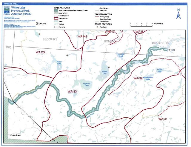
Trapping
There are portions of three licensed trap lines in White Lake Park Addition: WA-33, WA-32 and WA-09 (Figure 4).
Existing commercial fur harvesting operations may continue where the activity has been licensed or permitted since January 1, 1992. New operations, including trap cabins and trails, will not be permitted (OMNR 2000; 2003).
Transfers of active trap line licenses are permitted, subject to a review of potential impacts and the normal transfer or renewal conditions that apply
5.1.3 Industrial resources
Aggregate: There are no licensed aggregate pits, active or inactive within the White Lake Park Addition.
Specific to Crown land set aside and regulated under the Provincial Parks Act and the Crown’s legal obligations under the Environmental Assessment Act, the need for additional aggregates to be sourced in White Lake Provincial Park must be addressed as a policy statement in a management plan developed through public consultation and a regulation under the Provincial Parks Act. White Lake Provincial Park does not have a management plan developed through public consultation nor is there a regulation under the Provincial Parks Act. As such an application for any additional aggregate authorization(s) under the Aggregate Resources Act cannot proceed or be processed for sites within White Lake Provincial Park.
The Provincial Park and Conservation Reserves Act received Royal Assent on June 20. 2006 and is pending proclamation. Once the Act is proclaimed aggregate extraction in White Lake Provincial Park will not be permitted except for aggregate pits that are authorized under the Aggregate Resources Act on the day the Act is proclaimed. No additional authorizations will be permitted in the park after the proclamation of the Provincial Park and Conservation Reserve Act.
Figure 3: Bear Management Areas
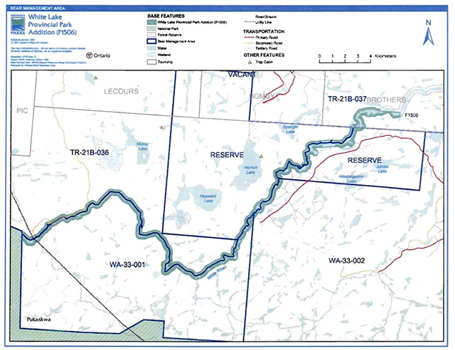
Enlarge figure 3: Bear Management Areas
Figure 4: Trap Line Areas
Enlarge figure 4: Trap Line Areas
Mineral Exploration and Mining: The mining and surface rights on ail lands within the park Addition have been withdrawn from staking under the Mining Act (1990). Mineral exploration and mining are not permitted in the park Addition.
Forest Reserves: There is one Forest Reserve (F1506) between the original White Lake Provincial Park and the White Lake Park Addition. The forest reserve in this area is part of the White River valley that is intended to be added to White Lake Provincial Park; however, preexisting mining lands - claims were given forest reserve status and thus placed under interim protection in order to remove lands from commercial forest operations, while still allowing for mineral exploration of pre-existing mining claims to continue. Policies for forest reserves are similar to the policies for new conservation reserves, except that mineral exploration, mining and related access will be permitted in a forest reserve. Commercial forest harvest and peat extraction will not be permitted, but most other resource and recreation uses will be permitted, provided they are consistent with the features and values being protected (OMNR 1999).
The intent for forest reserves is to regulate them as part of the adjacent park once the claims retire through normal processes. The forest reserve associated with White Lake Park Addition has been present here since 1981 and encompasses a total area of 1,408 hectares, split between 88 claims (Harper and Carre, 2001).
Hydro Development is a Permitted Non-conforming Use: Hydro development is permitted as a non-conforming use in three locations within the White Lake Park Addition (OMNR 1999, ) The three sites include: 1) a replacement of the existing White Lake Dam to be located at Fearless Rapids, 3.2 kilometres downstream of the existing White Lake Dam; 2) Chicagonce Falls where a two structure project will be undertaken at the falls and a location 1.6 kilometres downstream of the Chicagonce Falls; and, 3) Umbata Falls. The first two will be developed and operated by PicMobert First Nation while Umbata will be developed and operated by Pic-Heron Bay First Nation.
5.1.4 Access and crossings
Access
A forest access road occurs parallel to the river and there are two existing crossings of the park Addition. The main crossing is the CP Rail line over the White River in Laberge Township, just downstream from the original park boundary. There are several secondary and tertiary roads that enter into the park Addition from the main logging road known as Road 700. ATV users access the river using this road network, or by using the rail way right of way, where snowmobiles access the river in winter (Harper, 2002). Discussions will continue with the First Nations to determine access needs for new roads associated with the permitted non-conforming hydro use.
Roads
A forest access road parallels but is well outside the park Addition for 15 kilometres between the existing MNR dam and downstream to Domtar Rapid. Several tertiary roads branch from this forest access road which is known as Road 700. One of these, the secondary logging Road 760, crosses over the river at a temporary Domtar bridge, just upstream of Baptismon Rapid. The southern most limit of the Addition is crossed by a secondary logging road, known as the Umbata Falls Road, which is connected to a primary road to the west and north of the park Addition. A tertiary road parallels the river on the north side for six kilometres above Umbata Falls. The Umbata Falls Road follows the hydro line right of way (ROW) which crosses at a bailey bridge below Umbata Falls (Harper and Carre 2001). New roads will be developed associated with the development of permitted non-conforming hydro use at the approved sites.
Railway
There is one crossing of the boundary of the land presently classified as White River Provincial Park (upon the retiring of the mining claims in this area when they become part of White Lake Provincial Park). This corridor is not part of the White River Park addition.
Utility corridors
A utility corridor crosses the far western limit of the White River Park Addition. There will be utility corridors developed associated with the permitted non-conforming hydro use at the approved sites.
Recreational trails
Canoe Routes: The White river is an ancient canoe route with canoeing occurring throughout the park Addition. The White River Canoe Route begins outside and upstream of White Lake Provincial Park and continues to Lake Superior through the park Addition and Pukaskwa National Park.
Snowmobile Trails: The Ontario Federation of Snowmobile Clubs, Trunk Trail "D" (Superior Snow Challenge Loop) is located just north of the original White Lake Provincial Park. There is unauthorized snowmobile use along existing tertiary access roads. Snowmobile use on existing routes for access to LUPs and for recreational ice fishing may continue unless park values are threatened. Snowmobile use may be authorized on old forest access and tertiary roads. Off-trail snowmobile use is not permitted. New snowmobile trails may be considered though future planning with Aboriginal dialogue and public consultation (OMNR 2000).
ATV Trails: There are no designated all-terrain vehicle trails in the White Lake Park Addition; however there is unofficial use on Domtar Bridge at Domtar Rapid. Existing use of roads to access LUPs is permitted continue unless this use threatens park values. ATV use may be authorized on old forest access and tertiary roads; this use will be reviewed during future planning with Aboriginal dialogue and public consultation. Off-trail ATV use is not permitted (OMNR 2000).
Hiking Trails: There are no designated hiking trails in the White Lake Park Addition. New hiking trails may be developed if the need arises. Any proposed development within the park is subject to Environmental Assessment Act requirements.
5.1.5 Adjacent land management
Forestry
The lands adjacent to the White Lake Park Addition are located in the White River Forest Management Unit (unit number 60) and are managed consistent with the White River Forest Management Plan.
Forest reserves
The section of the land that runs along the White River in Laberge and Brothers townships, between the original White River Provincial Park and the White River Park Addition is the White River Forest Reserve (F1506).
Forest reserves are areas where protection of natural heritage and special landscapes is a priority, but some resource use can take place with appropriate conditions. The intention is that these lands will be added to White Lake Provincial Park when a claim or lease is retired through normal processes. Policies for forest reserves are similar to polices for new conservation reserves, except that mining and related activities will be allowed in a forest reserve. Commercial forest harvest, new hydroelectric power development, and peat extraction will not be allowed, but most other resource and recreation uses will be permitted, provided they are consistent with the features and values being protected (OMNR 1999).
Provincial parks
With the Exception of the existing portion of White Lake Provincial Park, there are no other Provincial Parks in the immediate vicinity of the park Additions (OMNR 2004).
The original White Lake Provincial Park (P1506e) is a natural environment class park. White Lake Provincial Park is located on Highway 17, and serves as a staging area for backcountry canoeing on the White River and beyond to Pukaskwa National Park. The park provides campground facilities which are popular with anglers and trans Canada travelers. White Lake Provincial Park will be managed according to Provincial Park policy and the park management plan and this amendment (OMNR 1987, 2004, 2007).
National Parks
Pukaskwa National Park is located adjacent to the western boundary of White Lake Provincial Park Addition. This national Park encompasses 187,800 ha of land and is protected under the National Parks Act.
Enhanced management areas
There are no enhanced management area in the immediate area surrounding the White Lake Park Addition (OMNR 2004).
General use area
There is only one general use area adjacent to White Lake Park Addition.
The Integrated multiple Resources Management General Use Area (G2694) encompasses 1,329,898 ha of Crown land. The primary activities in G2694 will be forest management, mineral exploration, mining, hydroelectric power generation, tourism and Crown land recreation. Lake trout lakes will be managed to protect and/or rehabilitate their respective lake trout populations and habitat Tourism lakes will be managed to protect their remote quality (OMNR 2004).
Adjacent tourism developments
There are no tourism developments immediately around the White Lake Park Addition. There are three commercial outpost camps ranging from three to five kilometres to the north of the halfway point, along the length of the White Lake Park Addition.
5.1.6 Land disposition
White Lake Park Addition is located within Brothers and Laberge townships and a large unsurveyed area.
No land disposition for private use or corporations will be permitted within the park Addition boundaries (OMNR 2000). With the exception of the hydroelectric development associated with existing commitments (OMNR 1999, 2004).
Land use permits, licenses of occupation, and unauthorized occupations
There are no known land use permits within the boundary of White Lake Park Addition.
There are no known licenses of occupation within the boundary of this park Addition. There are no known unauthorized occupations located within the boundary of White Lake Park Addition.
Patent land
There are no parcels of patent land in the White Lake Park Addition.
No new patent land will be sold in the White Lake Provincial Park Addition (OMNR 2000, OMNR 2004).
Waste disposal site
There are no authorized waste disposal sites in White Lake Park Addition or on adjacent lands.
Boat caches
There are no known authorized boat caches located within the boundary of the White Lake Park Addition. Boats are not permitted to be left unattended in the park without written permission from the superintendent under the authority of the Provincial Parks Act.
5.2 Aquatic ecosystems
Sustaining quality water resources is integral to the protection of park and adjacent lands. The MOE enforces applicable legislation and regulations for water quality.
5.2.1 Water management
Commitments have been made to Pic Mobert First Nation and Pic Heron Bay First Nations regarding potential hydro sites in this area. There are three sites; the ·first site is a replacement of the existing White Lake Dam to be located at Fearless Rapids 3.2 km downstream of the existing White Lake Dam, the second site is at Chicagonce Falls where a two structure project will be undertaken at the falls and a location 1.6 km downstream of the Chicagonce Falls; and a ·final project site at Umbata Falls. These hydro activities are as a result of existing commitments and will be treated as permitted non-conforming use (OMNR 1999 and OMNR 2004).
The removal of existing water control structures (non-hydroelectric) over time may be considered (OMNR 2004). New commercial hydroelectric developments will not be permitted (OMNR 2000).
5.2.2 Fisheries management
Fisheries management will complement the maintenance and enhancement of native, self-sustaining fish populations (OMNR 1992).
Fish habitat management may be considered through future planning (OMNR, 2004).
Fish stocking of native species may be considered through future planning, which will include Aboriginal dialogue and public consultation (OMNR 1992, OMNR 2004). Non-native fish species will not deliberately be introduced to park waters (OMNR 1992, OMNR 2004).
Sport fishing
Sport fishing is permitted within the park Addition. This activity is governed by legislation and regulations in the Fish and Wildlife Conservation Act (1997) and the Fisheries Act (1985). The Recreational Fishing Regulations Summary contains details on the applicable regulations for this area.
Commercial fishing
There are no commercial fishing operations within the boundary of the White Lake Park Addition.
New operations will not be permitted (OMNR 2004).
Commercial baitfish harvesting
Baitfish harvesting in White Lake Park Addition is located in five baitfish harvesting areas including WA0701, WA0034, WA0035, WA0033, WA0156 (Figure 5).
Figure 5: Commercial Baitfish Blocks
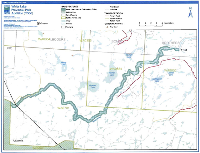
Enlarge figure 5: Commercial Baitfish Blocks
No new baitfish harvesting will be permitted within the boundary of White Lake Park Addition (OMNR 2004), however, existing baitfish harvesting units might be allocated if there is a record of activity since January 1, 1992 (OMNR 2004). If re-allocated, bait harvesting will be permitted to continue indefinitely in this park, however subject to possible conditions identified during park management planning (OMNR 2000).
Fish stocking
The stocking of native fish species may be considered through future planning, with Aboriginal dialogue and public consultation (OMNR 2004). The stocking of non-native fish species will not be considered (OMNR 2004).
6.0 Operations policies
6.1 Recreation management
6.1.1 Motorized recreation
Motorboats
The use of motorboats is permitted to continue, unless park values are threatened (OMNR 2004a). Long term management direction for motorboat use will be determined through future planning, which will include full Aboriginal dialogue and public consultation (OMNR 2004).
Aircraft
Aircraft landings are permitted in this waterway park. AU aircraft landings are subject to regulation and valid aircraft landing permits issued by the park superintendent under the authority of the Provincial Parks Act. Long-term direction for aircraft landings will be determined through future planning (OMNR 1992).
Snowmobiles
There are no authorized snowmobile trails within the park Addition. Snowmobile use on established routes for access to LUPs, and recreational ice fishing may continue unless park values are threatened. Snowmobile use may be authorized on forest access and tertiary roads. Off-trait snowmobile use is not permitted in the park. New trails may be considered during future planning, which will include Aboriginal dialogue and public consultation (OMNR 2000).
All-terrain vehicles
There are no authorized ATV trails within the park Addition. Unauthorized ATV trails that are documented may be permitted to continue until they are reviewed during future planning, with Aboriginal dialogue and public consultation. The park superintendent may discontinue existing unauthorized trails if it is determined that such trails threaten park features and values, create user conflicts or raise safety and/or liability issues. Existing use of forest and tertiary access roads is permitted to continue unless this use threatens park values. ATV use may be permitted on old forest access and tertiary roads. Off-road or off-trail use of ATVs will not be permitted. Proposals for new trails may only be considered during future planning with Aboriginal dialogue and public consultation (OMNR 2000).
6.1.2 Non-motorized recreation
Camping
The initial recreation assessment identified twelve unmanaged backcountry campsites associated with the canoe route through the park Addition (Kershaw, 2002).
Ontario Parks may assess the condition of existing backcountry campsites and may maintain, rehabilitate, or close sites as required. If there is an identified need, new backcountry campsites may be considered (OMNR 2004a). Long-term management direction for backcountry camping may be determined through future planning, with Aboriginal dialogue and public consultation.
Infrastructure will be permitted in order to protect park features and values in response to use, environmental deterioration and environmental protection requirements. Any proposed development in the park must fulfill the requirements of the Environmental Assessment Act.
Hiking
There are no authorized hiking trails within the park Addition.
Unauthorized hiking trails and other non-mechanized trails that are documented may be permitted to continue until they are reviewed in future planning, with Aboriginal dialogue and public consultation. The park superintendent may discontinue existing unauthorized trails if it is determined that such trails threaten park features and values, create user conflicts or raise safety and/or liability issues.
If there is an identified need, the development of new hiking trails may be considered through future planning which will include Aboriginal dialogue and public consultation. Trail infrastructure to protect park values and features will be permitted. Any proposed development within the park is subject to Environmental Assessment Act requirements.
Canoeing/kayaking
Existing uses may continue, unless park values are threatened (OMNR 2004a). Infrastructure to protect park features and values may be permitted and developed in response to use, environmental deterioration and environmental protection requirements.
6.1.3 Emerging recreation uses
There are emerging recreational uses for which there is limited or no policy to deal with their management (e.g., adventure racing, geocaching). The park superintendent will use legislation, policy, and guidelines which are in place to manage emerging uses.
6.2 Development
There is no existing park infrastructure located within the boundaries of White Lake Park Addition. Infrastructure to protect park features and values may be permitted and developed in response to use, environmental deterioration, and environmental protection requirements. Any proposed development within the park will be subject to future planning and the requirements of the Environmental Assessment Act.
6.3 Commercial tourism
Infrastructure for commercial tourism does not exist within the White Lake Park Addition.
New commercial tourism facilities may be considered where they would be consistent with park policy (OMNR 2004a). Any development must meet the requirements of the Environmental Assessment Act. Existing authorized tourism facilities may continue subject to management prescriptions determined through future planning. Existing tourism facilities (e.g., LUPs, leases) may be eligible for enhanced tenure, and decisions will be made in future planning.
7.0 Cultural resources
An assessment of the cultural resources specific to the White Lake Park Addition has not been completed at this time, however, upon completion; management of any cultural features and values within this park will be directed toward protection and heritage appreciation (OMNR 1992).
8.0 Heritage education
Natural Heritage Education (Visitor services) will be managed in accordance with the park management plan. A natural heritage education plan will be prepared in keeping with the direction provided in the management plan to manage education activities. This plan will provide specific operational guidelines on how to carry out natural heritage education programs.
The Park and area themes will be highlighted primarily through self-use information and facilities. Themes of the Park include:
- Logging the White River Watershed.
- The Canadian Pacific Railway.
- The Fur Trade.
- The Boreal Forest.
- Outdoor Recreation - canoe tripping.
- Glaciation and the Canadian Shield.
Basic literature and support information may be developed to describe White Lake Park Addition in the context of White Lake Provincial Park and Ontario’s provincial parks and protected areas. Boundary limits, significant heritage features and permitted uses of the natural environment park may be included in park literature.
Prospective visitors to White Lake Park Addition may be informed about the sensitivity and significance of this area through park literature.
Prospective visitors may be informed about the presence of and need to respect adjacent private lands, through park literature.
9.0 Research
Scientific research, by qualified individuals, which contributes to the knowledge of natural and cultural history and to environmental and recreational management, will be encouraged in the park. Ontario Parks will encourage institutions to undertake research projects. AU research programs will require the approval of Ontario Parks and will be subject to park policy and other applicable Legislation. Ontario Parks may approve the research of any natural, cultural and social features or values by qualified researchers. Any materials removed will remain the property of the Ontario Ministry of Natural Resources.
Approved research activities and facilities will be compatible with the park’s protection objective. Any site, which is affected, will be rehabilitated as closely as possible to its original state. Environmental assessment requirements will apply.
Research must contribute to the knowledge of natural and cultural history, and to environmental and recreational management. Research must be conducted in such a manner as to safeguard protection objectives.
10.0 References
Fisheries Act, 1985.
Harper, T. and Carre, K. 2001. Ontario Parks OLL Implementation Database, Site Name: White Lake Addition (P1506).
Kershaw, W. 2002. White Lake Provincial Park Addition- P1506, Recreational Assessment, Inventory Report- Version 1.5.
Migratory Birds Convention Act, 1994.
Morris, E. 2001. White Lake Provincial Park Addition (P1506): Life Science Checksheet.
Natural Resources Values Information System, 2004.
Ontario Ministry of Natural Resources (OMNR). 1974. A Topical Organization of Ontario History. Historic Sites Branch Division of Parks.
Ontario Ministry of Natural Resources (OMNR). 1987. White Lake Provincial Park Management Plans ·
Ontario Ministry of Natural Resources (OMNR). 1992. Ontario Provincial Parks Planning and Management Policies, 1992 Update, Parks and Natural Heritage Policy Branch.
Ontario Ministry of Natural Resources (OMNR). 1994. Park Policy, Procedure and Bulletin "PM 11.02.011 Preparation of Interim Management Statements" e Provincial Park Operations Branch.
Ontario Ministry of Natural Resources, (OMNR). 1999. Ontario’s Living Legacy Land Use Strategy, Queen’s Printer for Ontario.
Ontario Ministry of Natural Resources (OMNR). 2000. Ontario Provincial Park Policy as Amended by the Ontario Living Legacy Land Use Strategy.
Ontario Ministry of Natural Resources (OMNR). 2002. Fire Management Strategy for Ontario. (Draft). Aviation and Fire Management Branch.
Ontario Ministry of Natural Resources (OMNR). 2004. Crown Land Use Policy Atlas.
Ontario Ministry of Natural Resources (OMNR). 2004a. Hunting Regulations Summary: Fall 2004-Spring 2005.
Ontario Ministry of Natural Resources (OMNR). 2004b. Recreational Fishing Regulations Summary.
Ontario Ministry of Natural Resources (OMNR). 2005. Class Environmental Assessment for Provincial Parks and Conservation Reserves.
The Society for the Diffusion of Useful Knowledge, 1827. North America Sheet IV Lake Superior Reduced from the Admiralty Survey (#10106). http://www.raremaps.com/cgi-bin/map-builder.cgi?America+Midwest+10106 [link no longer active]
11.0 Appendix A: Background information
| Name | White Lake Park Addition (P1506) |
|---|---|
| Classification | Natural Environment |
| Ecoregion/ecodistrict | 3E-4 (Tip Top Mountain) |
| OMNR Administrative Region/District | North East Region - Wawa |
| Total Area (ha) | 4,048 |
| Regulation date and number | 331/06 |
Representation
Geological features
Bedrock Geology consists of an undifferentiated, foliated to gneissic, tonalite suite of intrusive rocks which is well exposed along the length of the river in shoreline outcrops and cliffs. In Brothers Twp, bedrock consists of mafic to felsic metavolcanics and metasedimentary sequences (Kor, 2003). This rock has been assigned to the Pukaskwa Gneissic Complex, and lies in the Wawa Subprovince, Superior Province, Canadian Precambrian Shield (Kor, 2003).
Surficial Geology includes sand, silt, clay and minor boulder lags and unconsolidated bluffs, with occasional oxbows and meanders along the lower course of the river. The lower part of the river may have been instrumental in channelling glacial meltwaters off the Shield into the Superior basin, and may have been occupied by the upper reaches of glacial Lake Minong in early postglacial time (Kor, 2003).
The waterway includes that portion of the White River from the existing White Lake Provincial Park to Pukaskwa National Park- 55 kilometres. There’s a 90 metre drop in elevation in the portion of river within the White Lake Park Addition, falling an average of four metres every kilometre.
Rock outcrops are found intermittently in the park Addition. Sections that have bedrock controlled channel characteristics are prominent due to white-water that appears as swifts, rapids and falls. Swifts or chutes occur where the river surges through a bedrock constriction to create fast moving water without surface disturbance. Rapids occur where flows are obstructed by boulder deposit or by more resistant bedrock in the channel bottom that breaks the surface flow to create white water sections (Kershaw, 2002).
Biological features
This park Addition extends south along the White River providing linkage of the original park with Paukaskwa National Park. The dominant landform vegetation type that is represented here is lacustrine deposit. With the minimum waterway park boundary of 200 metres there is incomplete and fragmented inclusion of upland forest types, with boreal forest that has high concentrations of conifer, especially near the Lark Superior coast. Other areas along the river contain sections of poplar, mixed deciduous and mixed deciduous/coniferous forest. In total, over 161 and form vegetation combinations are represented here. Unlike most of the interior waters in this area, the White River contains a diversity of fish species. This includes one of the few healthy walleye populations in the area (Morris, 2001).
The vegetation associations are:
- 65% upland white birch- poplar- Jack pine / Jack pine / black spruce- Jack pine
- 32% wetlands, riparian open to brush alder- better drained river shores have pockets of white cedar and in places with mesic conditions there are scattered white pine; and
- 3% backshore, shoreland and cliff outcrops as rock barrens
Cultural resources
An investigation and analysis of the cultural resources specific to White Lake Provincial Park Addition has not been completed at this time.
Future planning will use a provincial framework, The Topical Organization of Ontario History (OMNR 1974) and updates and discussions with other agencies, First Nations and interest groups to identify cultural heritage values and features and their significance within White Lake Provincial Park Addition. This information may be used to develop management guidelines to conserve and protect representative archaeological and historical values and features, as well as provide direction for further research.
Recreation and tourism
The White Lake Park Addition follows the White River from the original White Lake Provincial Park to Pukaskwa National Park; a 55 kilometre stretch of the White River. This length of the river is navigable although there are portages around the 20 rapids and four falls. Some of the open water in off channel ponds and oxbows can be paddled and provide viewing of very calm wetlands. Among the many features on the river Umbata Falls is striking given the height of the falls and its location as it lies within a two kilometre long gorge with a drop in excess of 40 metres. Below the falls and turbulent gorge, still above these features above the gorge is an excellent place to explore and view erosion and depositional features. Other recreational activities include hunting and fishing. Fishing occurs as travelers pass down the waterway (Kershaw, 2002).
Inventories:
| Survey level | Earth science | Life science | Cultural | Recreational |
|---|---|---|---|---|
| Reconnaissance | PSG Kor 2007 | Morris, 2001 | Kershaw, 2002 |
Footnotes
- footnote[1] Back to paragraph Transfers include situations where a license is surrendered with a request that it be immediately reissued to another individual or organization that is assuming an existing operation. Trap cabins are considered part of a trapline and would be transferred with the trapline for the purposes of trapping. If a trapline license is revoked or surrendered, all portions of the registered line within the park will be rescinded from the legal description of the trap line (OMNR 2003).