Whitesand Provincial Park Management Statement
This document provides policy direction for the protection, development and management of Whitesand Provincial Park and its resources.
Interim Management Statement
©2004, Queen’s Printer for Ontario
Printed in Ontario, Canada
Additional copies of this publication can be obtained from the:
Ontario Parks Northwest Zone
Suite 221D, Ontario Government Building
435 James Street South
Thunder Bay, ON P7E 6S8
Telephone: (807) 475-1321
Approval statement
This Interim Management Statement will provide interim direction for the management of Whitesand Provincial Park until a comprehensive Park Management Plan is prepared.
This statement will provide the basis for the subsequent preparation of the Park Management Plan.
I am pleased to approve this Interim Management Statement for Whitesand Provincial Park.
Signed by:
Tim P. Sullivan
Zone Manager, Ontario Parks
North West Zone
February 2004
Prelude
The purpose of this Interim Management Statement is to identify:
- park values, which are to be protected;
- resource management prescriptions necessary to protect these values in their current state; and
- restrictions, according to existing park policy, on use of the natural resources within the park.
This Interim Management Statement is not intended to replace a Park Management Plan. Rather it is intended to guide the use of natural resources and related activities within the park until such a time as a Park Management Plan is prepared.
The guidelines that have been developed are based upon information contained in the Ontario Provincial Parks Planning and Management Policies (1992) and Ontario’s Living Legacy Land Use Strategy (1999).
Background information
| Name | Whitesand Provincial Park |
|---|---|
| Classification | Waterway |
| MNR District | Thunder Bay |
| MNR Region | Northwest |
| Total area (ha) | 11,337 |
| Ecoregion / ecodistrict | 3W-1, 3W-3 |
| Date in regulation | 2003 |
Regional context and site maps are attached at the end of the document.
Life science representation
Site type / landscape unit
Landform/vegetation representation analysis
A representation analysis (Lipsett-Moore et al, in prep.) in 2003 of the Landform/Vegetation (L/V) Classes within the ecodistricts applicable to Whitesand Provincial Park reveals important contributions to representation benchmarks for Ecodistrict 3W-1. The park makes no important contributions in Ecodistrict 3W-3.
Ecodistrict 3W-1
The park contributes to approximately 50% (42/83) of the Ecodistrict’s L/V Classes. The following L/V types within Whitesand Provincial Park make an important contribution (i.e., at least 20%) to achieving L/V representation benchmarks within Ecodistrict 3W-1:
- Bedrock-Dense Deciduous Forest
- Glaciofluvial outwash deposits – Dense Coniferous Forest
- Bedrock – Sparse Deciduous Forest
- Glaciofluvial outwash deposits-Mixed Forest – Mainly Coniferous
- Glaciofluvial outwash deposits-Mixed Forest – Mainly Deciduous
- Glaciolacustrine deposits-Dense Deciduous Forest
- Fluvial deposits-Mixed Forest – mainly Coniferous
- Glaciofluvial outwash deposits – Mine Tailings, Quarries and Bedrock
Ecodistrict 3W-3
The small area of the park contained within ecodistrict 3W-3 contributes to approximately 6% (5/81) of the Landform/Vegetation (L/V) Classes. However all those L/V Classes are already completely represented by other parks and protected areas.
Species / communities
The park contains a diverse range of Forest Ecosystem Classification (FEC) vegetation or "V" types including:
- V9 (Trembling Aspen Mixedwood)
- V5 (Aspen Hardwood)
- V4 (White Birch Hardwood and Mixedwood)
- V32 (Jackpine-Black Spruce/Ericaceous Shrub/Feathermoss)
- V19 (Black Spruce Mixedwood/Herb Rich)
- V30 (Jack Pine-Black Spruce/Blueberry/Lichen)
- V34 (Black Spruce/Labrador Tea/Feathermoss)
- V33 (Black Spruce/Feathermoss)
- V38 (Black Spruce/Leatherleaf/Sphagnum)
See (Sims et al. 1997)
The park includes winter habitat and a travel corridor for woodland caribou and provides good habitat for moose, black bear, small furbearers, bald eagle, osprey and white pelicans. (Geowest 2001)
Earth science representation
| geological theme | feature(s) |
|---|---|
|
Bedrock Geology
|
Surficial Features
|
Cultural resource representation
| cultural resource representation | theme segment |
|---|---|
| Northern Hunters and Fishers | Late Woodland Period (800 AD) |
Recreational opportunities
| Day Use | Car Camping | Wilderness/Backcountry |
|---|---|---|
| Wildlife viewing – caribou, moose Scenic viewing – Bad Medicine Lake Angling / Hunting – Jojo, Whitesand, Ratte Lakes | N/A | Backcountry Canoe Camping (part of Pikitigushi River Canoe Route) Remote Tourism – Ratte Lake |
Inventories
| Level/type | Reconnaissance / completion date | Detailed / completion date | Required |
|---|---|---|---|
| earth science | Yes – Feb (2001) | Yes – detailed | |
| life science | Yes – Feb (2001) | Yes – detailed | |
| cultural | Yes - detailed | ||
| recreational | Checklist – Oct (2000) | August (2003) | No |
| other |
Whitesand Provincial Park Interim Management Statement
I. Introduction
Whitesand Provincial Park was established as part of Ontario’s Living Legacy, a land use strategy that guides the planning and management of Crown lands in central and portions of northern Ontario. Under this initiative, released July 1999, 378 new protected areas were identified. Whitesand Provincial Park is part of this significant expansion of Ontario’s protected areas system.
Whitesand Provincial Park includes an area of 11,337 ha, and is designated a Waterway Class Park in recognition of its representative natural features and recreational water route. The park stretches in a northeast direction, 45 km along a system of rivers and lakes from Jojo Lake to the south to Bad Medicine Lake / Dazzle Creek to the north. It is located 15 km northeast of the community of Armstrong and Whitesand First Nation.
The park serves as an important wildlife travel corridor, along the Whitesand and Pikitigushi River systems, specifically linking Wabakimi Provincial Park, Windigo Bay Provincial Park and Lake Nipigon.
II. Aboriginal interests
Whitesand First Nation has identified the area of Whitesand Provincial Park as being part of their traditional lands. Current First Nation activities within the park include seasonal occupations and natural resource harvesting (trapping, fishing, hunting, and gathering). There are currently no formal land claims regarding Whitesand Provincial Park.
Guideline:
Any management guidelines will reflect the Ontario government’s approach to aboriginal rights:
- All decisions related to the identification, planning or disposition of provincial park lands, or other lands set aside to protect significant natural or cultural heritage values, will be the subject of public consultation. Aboriginal peoples who identify traditional ties to those lands will be integral to the consultation and decision making processes. In some cases there may be a need for separate consultation or negotiation processes to address Aboriginal interest in park lands. If required, some issues regarding how a park is used may also be the subject of negotiation with Aboriginal people.
- The Government of Ontario will consider all the available options when seeking to determine the land component, if any, during negotiations involving land claim settlements with First Nations. Options for uses that involve lands, which are not to be considered for provincial park purposes, will be preferred.
- As described in the Province’s Interim Enforcement Policy (1991), aboriginal people hunting or fishing in provincial parks will be subject to all relevant treaties and However, an agreement reached between the Province and a First Nation may modify the application of those treaties and laws (Ontario Provincial Parks Planning and Management Policies, 1992).
Ontario Parks and Whitesand First Nation agree to work cooperatively and in good faith with each other and with other parties with respect to the planning and management of Whitesand Provincial Park.
III. Land tenure/acquisition/disposition
Composed of Crown land, with a boundary set at 1000 m from the high water mark, Whitesand Provincial Park contains the following lakes (from south to north): Jojo, Whitesand, Nicholls, Haile, Selassie, Derraugh, Wash, Gort, Ratte and Bad Medicine. It includes Whitesand River, Pikitigushi River and Dazzle Creek.
The park is bounded
- on the north by Wabakimi Provincial Park
- on the south by the CNR mainline right-of-way, Windigo Bay Provincial Park and the Lake Nipigon Conservation Reserve (C2247)
- on the east by Crown Land and the Pikitigushi Enhanced Management Area (E2251w) and
- on the west by Crown Land and the Pikitigushi Enhanced Management Area (E2251w)
No transmission lines or gas pipeline corridors cross the park, though the CNR mainline abuts the southern boundary. The Pikitigushi, McKinley, and East Gort Lake forest access roads pass through the park. No land disposition has occurred, with the exception of one Land Use Permit (LUP) issued for a commercial outpost camp on Ratte Lake. There are no mining claims within the park.
Guideline:
- No new land disposition for the private use of individuals or corporations will be considered within the park
- Land disposition for commercial use may occur, under the authority of a land use permit or lease, subject to approval through planning
- The existing outpost camp on Ratte Lake may be eligible for enhanced tenure
IV. Natural resource stewardship
Whitesand Provincial Park (11,337 ha) contributes to Ontario Park’s Waterway Class targets of Ecodistricts 3W-1 and 3W-3. The park has a modified continental climate typified by short, hot summers and long, cold, dry winters. Weakly broken ground and end moraines, strongly broken bedrock cliffs, lacustrine and outwash deposits characterize Whitesand Provincial Park. The park’s main value is its capacity to provide a travel corridor and winter habitat for woodland caribou.
Lands and waters
The southern portion of the park is of generally low relief whereas the northern portion, near the vicinity of Bad Medicine Lake is very rugged with a significant amount of exposed bedrock and ridges.
There is a minor height of land between Haile and Nicholls Lakes resulting in two watersheds that drain the Whitesand Provincial Park area towards Lake Nipigon and eventually the Atlantic Ocean. The northern area, including Ratte to Haile is drained via the Pikitiguishi River system and the Whitesand River drains Selassie to Jojo Lakes.
The park lies within two east-trending subprovinces of the Archaean Superior Province: the Wabigoon Subprovince that occurs south of Ratte Lake and the English River Subprovince to the north. A major fault zone (Pashkokogan) separates these two subprovinces. The English River subprovince is composed predominately of highly metamorphosed and migmatized clastic sedimentary rocks that are as young as 2.7 billion years old; felsic intrusive rocks formed between 2650 to 2700 million years ago (Breaks 1991). The area north of Ratte Lake is within the Abamasagi batholith, a peraluminous granite suite (ibid). The Wabigoon subprovince is composed of metavolcanic and subordinate metasedimentary rocks of the Caribou Lake greenstone belt, surrounded by plutonic intrusive rocks (Blackburn et al. 1991). There are two significant north-trending faults: one from Whitesand to Jojo Lakes and the other from Ratte to Derraugh Lakes. Mesoproterozoic diabase, related to the Midcontinent Rift, intrudes the Archaean rocks (Sutcliffe 1991).
The surficial geology has largely resulted from Pleistocene continental glaciation. The Whitesand River valley is in-filled with lacustrine sediments while the area north of Derraugh Lake is overlain by weakly to moderately broken ground moraine. It is believed that the Whitesand River valley was most likely a spillway for glacial Lake Agassiz. The relief is undulating with the exception of the Bad Medicine Lake area where local relief is up to 100 m. Soils are generally well-drained, sand-based and variably textured, with major organic deposits (formed in remnant meltwater channels) located around Dazzle Creek, the east side of Jojo Lake and southward. The lacustrine deposits of the Whitesand River valley may generate deep soils, whereas north of Derraugh Lake the soils are shallow and bedrock-controlled. A dune feature is prevalent between Jojo and Whitesand lakes.
Based on its bedrock geology, the park’s mineral potential is high from the west end of Haile Lake to the south end of Ratte Lake, where it is underlain by the Caribou Lake greenstone belt (hosting gold-silver, base metal and rare element-bearing pegmatite occurrences). The remaining portion, located within granitoid and related metasedimentary terranes, has a low to unknown mineral potential rating (OMNDM 1999).
Guideline:
- Aggregate extraction is not permitted
- Mineral exploration and mining are not permitted
- Commercial hydro development is not permitted
- The need for any water control structures will be determined during the park management planning process
- Peat extraction is not permitted
Vegetation management
Two eco-zones exist within the park: Big Lake-Crescent Lake and Lake Kelvin. The park contains a diverse range of Forest Ecosystem Classification (FEC) vegetation or "V" types – including poplar and birch mixedwood, coniferous mixedwood and pure jack pine and black spruce forest. The park is representative of upland areas within Site District 3W-3. In 1996 a forest fire swept through a portion of the park just south of Whitesand Lake to Nicholls Lake. In 2001, a fall storm event resulted in significant blowdown throughout the Armstrong area.
Of particular interest in the park is the vegetation type that supports woodland caribou wintering range. A woodland caribou population calves on the Lake Nipigon islands, and in winter moves into the Jojo-Wagaming-Armstrong airport triangle area. Caribou have also been documented using the frozen lake and mature forest landscape of the Whitesand River valley for travel south of Wabakimi Provincial Park (Hyer 1997).
The park is located within the Armstrong Forest Management Unit (FMU 030) under Norampac Inc. SFL# 542255. Numerous forest management activities have taken place within and adjacent to the park, with most harvesting occurring in the 1980s but beginning in late 1970s. Most stands associated with cutover and/or burns are less than 20 years old, with the remaining forest generally between 60-100 years in age. Major harvest blocks within the park are east / west of Gort Lake, and on the south side of the park between Haile and Derraugh Lakes.
Guideline:
- Commercial forest operations are not permitted
- Fuelwood cutting is not permitted
- In the absence of a Fire Management Plan for the park, the fire management objectives of the surrounding fire management zone will apply. All human caused fires will be suppressed
- The need for a Vegetation Management Plan, which will include prescriptions for fire management and caribou considerations, will be determined through park management planning
- Suppression of non-native insect/disease infestations is permitted.
- In recently harvested areas within the park, renewal plans that satisfy industry commitments and that meet park objectives may be developed and implemented subject to Class Environmental Assessment Act
- Ontario Parks will act as a plan advisor and reviewer during the Forest Management Planning Process. This process ensures that park values and park-related values are recognized and that protection and mitigation measures are addressed in the development of the forest management plan
Wildlife management
Whitesand Provincial Park is an important wildlife travel corridor between Lake Nipigon and Wabakimi Provincial Park and contains significant habitat for woodland caribou. Woodland caribou were classified as "vulnerable" by the Committee on the Status of Endangered Wildlife in Canada (COSEWIC) in 1984 and were upgraded to "threatened" in 2000. The Whitesand River corridor has been documented as a caribou migration route (Hyer 1997) and the Lake Nipigon remnant island population is known to winter in the Windigo Bay – Armstrong Airport – Jojo Lake area.
Whitesand Provincial Park is within Wildlife Management Unit 16C. Moose are present in relatively low numbers in the area, though sport hunting is a popular activity in the Jojo / Whitesand Lakes area. Haile and Nicholls Lakes are identified as aquatic feeding areas for moose.
There are four active commercial traplines (NG51, NG52, NG60, NG61) located within the park. Three trap cabins exist within the park, one on Ratte Lake and two on Jojo. Trapping harvest includes beaver, mink, pine marten, fisher, river otter, weasel, lynx, red fox and timber wolf.
Whitesand Provincial Park lies within the following active Bear Management Areas (BMAs): TB-16C-014, TB-16C-021, and TB-16C-024. BMA TB-16C-098 includes a portion of the park and is currently unallocated.
The park provides habitat for many other noteworthy species typical of the boreal forest such as: bald eagles and osprey. The provincially "endangered" American white pelicans nest in nearby Lake Nipigon and are occasionally observed within the park.
Guideline:
- Wildlife monitoring may be permitted. The need for a Wildlife Management Plan will be addressed during future park management planning processes
- Sport hunting can continue in Whitesand Provincial Park. Restrictions on hunting will be determined through park management planning
- Commercial bear hunting will be allowed to continue in areas of the park where it has traditionally occurred. When a management plan is approved, any hunting that is occurring in a nature reserve zone will be addressed through the management planning process consistent with OLL-LUS and Park Policies
- In situations where licenses have not issued and inventories have been completed that identify candidate or probable nature reserve zones, licensing should not be issued for these areas
- Existing commercial bear hunting operations are permitted to continue but the introduction of new operations will not be allowed
- The issuance of licenses or permits for commercial trapping will be allowed where the activity has been licensed or permitted since January 1, 1992 unless:
- The government has taken action to discontinue the activity
- Proceeding would create/aggravate resource sustainability issues (e.g., wildlife management reasons, impacts on values in nature reserve zones) or
- Licensing or permitting should be deferred due to Aboriginal issues
- Status Indians exercising treaty rights are permitted to continue trapping, subject to applicable legislation and regulation.
- Snowmobile trails used for access to the trap lines are permitted.
- No new commercial fur harvesting operations will be permitted, including new cabins and trails. The relocation of existing trails will be subject to ecological principles and park management planning
- Aboriginal people are permitted to continue trapping and hunting, subject to relevant treaties and laws
Fisheries management
Whitesand Provincial Park provides angling opportunities primarily for walleye and northern pike. Jojo and Whitesand Lakes have a northern pike fishery, Haile has a walleye fishery and the remaining lakes contain both. The majority of the lakes within the park are classified as cool under ARA (Aquatic Resource Areas). The Whitesand River along with one small lake between Jojo and Whitesand Lake is classified as a cold water system. Cold water systems may contain salmonid species, in this case brook trout. The majority of the lakes south of McKinley Lake Road are fairly shallow, graminoid and aquatic vegetation lined, with assorted minnow species. The lakes further north exhibit more depth and bedrock exposure. Four (4) active baitfish harvesting blocks exist within the park.
Guideline:
- Fisheries monitoring may be permitted. The need for a Fisheries Management Plan will be addressed through park management planning
- Sport fishing is permitted subject to the relevant Ontario Sport Fishing Regulations
- Treaty rights to fish are not affected
- The issuance of licenses for baitfish harvesting will be allowed where the activity has been licensed or permitted since January 1, 1992 unless:
- The government has taken action to discontinue the activity.
- Proceeding would create/aggravate resource sustainability issues (e.g., wildlife management reasons, impacts on values in nature reserve zones) or;
- Licensing or permitting should be deferred due to Aboriginal issues.
- In accordance with Ontario Provincial Parks Planning and Management Policies (1992), live baitfish should not be used or possessed in this provincial park. Until such time as a regulation is established, Ontario Parks will discourage the use or possession of baitfish in Whitesand Provincial Park
V. Cultural resources
To date, the cultural resources of Whitesand Provincial Park have not been rigorously investigated. There is one known archeological site: a campsite of the Late Woodland Period (800 AD). There is extremely high potential for pre-contact First Nation’s sites along the Pikitiguishi River system due to its association with Lake Nipigon and archeological sites within Wabakimi Provincial Park. The Whitesand River, though never formally investigated, has limited potential for historical sites (Bill Ross, personal communication, 2001).
Guideline:
- Further inventory is required to assess the cultural resources of Whitesand Provincial Park. Approved archeological fieldwork will be encouraged
- The locations of any archeological sites will not be public information. Necessary measures (access/development restrictions) to protect the integrity of any archeological sites will be implemented
- The need for a Cultural Resources Plan/Strategy for cultural features/sensitive areas will be determined through consultation and cooperation with Whitesand First Nation and park management planning
VI. Existing/proposed development
Existing development within Whitesand Provincial Park is associated with forestry, trapping, and remote tourism activities.
Guideline:
- Commercial activities within the park will be consistent with park policy
- Existing tourism facilities and related activities will remain, subject to park management planning
- New tourism facilities may be considered only through park management planning.
- Development of access zones and car/backcountry campsites will be addressed via park management planning
- Continuing custodial management for roads contained within the park and capital development of new/additional roads and trails will be determined through park management planning
- Future road crossings for forestry operations outside park boundaries may be permitted, subject to provisions of the Environmental Assessment Act including park management planning and forest management planning
- New ATV and snowmobile trails may be considered during park management planning
- Guidelines for access roads are described in Section VIII - Access
VII. Recreation activities
Whitesand Provincial Park possesses recreation values that include opportunities for remote tourism, backcountry canoeing, wildlife viewing, as well as sport angling and hunting. There are a limited number of backcountry campsites associated with canoeing and one outpost camp on Ratte Lake.
There is no continuous waterway contained within the Park. Two portions of documented canoe routes use the northern half of the park (Nipigon Canoe Country Section Sheets). The Pikitigushi River system from Wabakimi Provincial Park to Lake Nipigon is a lightly used canoe route. Its main feature is the Gooseneck Rapid and scenic terrain at Bad Medicine Lake. An alternate and much less traveled route diverges west from Gort Lake on the Big River towards Linklater and Caribou Lakes. There is no regular portage maintenance. Whitesand River is navigable pending seasonal water level variation and blowdown.
Sport fishing and hunting appear to be the most popular activities in this area. The Whitesand and Pikitiguishi River systems provide opportunities for recreational fishing, though there are currently few known details on species richness and density. Moose hunters return annually to hunt near Whitesand Lake. Hunters also use the network of old logging roads around Haile, Derraugh, Wash and Gort Lakes.
Pikitiguishi Lake, a very popular fishing lake for walleye and northern pike, abuts the eastern portion of the park. Access is gained to this lake and subsequently Whitesand Provincial Park via the Pikitiguishi Road.
A few recreationally significant beaches are found on Jojo, Whitesand and Ratte Lakes that are used for shore lunches. Of curiosity and point of interest is an abandoned bush plane (20+ years) located at the south end of Wash Lake.
There are no designated snowmobile or ATV trails in the park.
Guideline:
- Park management planning will determine policies for recreation management, including camping, boating and aircraft landing
- Self-guided nature appreciation and wildlife observation is permitted
- Sport fishing and hunting are covered under the Fisheries and Wildlife Sections
- The use of snowmachines/all-terrain vehicles on authorized trails, as designated by the Park Superintendent, will be permitted to continue subject to current road closures and prescriptions determined through park management planning
- Non-resident Crown Land Camping permit fees will apply
- Boat cache locations will be identified. No new boat caches are to be established
VIII. Access
Whitesand Provincial Park is accessed mainly via the Pikitigushi Road. Two road closures restrict vehicle access to the park, as follows:
- East Gort Lake Road (approximately 7 km from Pikitigushi Road Junction) &
- McKinley Road (approximately 11 km from the Pikitigushi Road Junction)
Both roads are closed to unauthorized vehicles to protect tourism and caribou values. There are no restrictions on walking these roads.
Guideline:
- Where alternative access does not exist or road relocation is not feasible, existing forest access roads will continue to be available for access for forest management
- The East Gort Lake Road system was formally abandoned in the 1990-1995 Timber Management Plan. This road is no longer considered an existing road. This road is closed to unauthorized vehicles at the first water crossing east of the park
- The McKinley Road is closed to unauthorized vehicles at the western boundary of the park
- Public access into the park from other existing/non-restricted roads will be permitted to continue pending park management planning
- Thunder Bay District MNR will maintain signage and provide compliance monitoring for road closures. No road maintenance will be performed
- Decisions on new roads, parking facilities and long-term management of roads abutting / crossing park lands will be addressed via park management planning
- Aircraft landing on water may be permitted under the authority of a valid aircraft landing authorization as per Reg. 952/01, s.24(2) under the Provincial Parks Act
- Access by Aboriginal people exercising their Treaty rights is not affected
IX. Client services
There are currently no client services for Whitesand Provincial Park. Canoe route information is available from local tourist outfitters.
Guideline:
- Client services will be limited to a map/brochure until an approved park management plan is completed. Development of an operations plan and a natural heritage education strategy will be considered when developing the park management plan
X. Research and inventories
Reconnaissance level earth and life science inventory reports in were completed in 2001. A detailed recreation inventory was completed in 2002.
Guideline:
- Detailed earth science and life science inventories will be undertaken when funding permits
- Additional research / inventories to document park values may be permitted
- OMNR, Ontario Parks or partnered groups and individuals may undertake research projects subject to the approval of the Park Superintendent and Zone Manager
- Discussions will be held with Whitesand First Nation to determine the need to inventory Aboriginal cultural resources, and to develop appropriate strategies to conserve and manage these resources
XI. Marketing
Marketing of Whitesand Provincial Park has to date been limited to Ontario Living Legacy (OLL) initiatives.
Guideline:
- When resources are available, Ontario Parks may promote Whitesand Provincial Park with methods consistent with other provincial parks
XII. Sources/references
Breaks, F.W. (1991). English River Subprovince. In P.C. Thurston, H.R. Williams, R.H. Sutcliffe, & G.M. Scott (Eds.), Geology of Ontario (pp.239-278). Toronto: Queen’s Printer for Ontario.
Domtar Inc. (2000). Armstrong Forest 2000-2020 Forest Management Plan.
Geowest Environmental Consultants Ltd. (2001). Earth and Life Science Inventory – Reconnaissance for Whitesand Provincial Park. Unpublished Report.
Gollat, R. (2000). A Habitat Management Strategy for the Conservation of Woodland Caribou on the Armstrong Forest. Ontario Ministry of Natural Resources (OMNR)
Hyer, Bruce T. (1997). Effects of Roads and Log Hauling on Woodland Caribou Use of a Traditional wintering Area near Armstrong, ON. (Graduate Thesis, Lakehead University, M. Forestry).
Lipsett-Moore, G., Kingston, S.
Moore, T. and J. Cameron (2000) Recreation Inventory Checksheet: Whitesand Provincial Park. OMNR Unpublished Report.
Ontario Ministry of Natural Resources (OMNR). (1999). Ontario’s Living Legacy Land Use Strategy. Queen’s Printer for Ontario, Ontario.
Ontario Ministry of Natural Resources (OMNR). (1992) (update). Ontario Provincial Parks: Planning and Management Policies.
Ontario Ministry of Natural Resources (OMNR). (2000). NRVIS – Thunder Bay District.
Ontario Ministry of Natural Resources (OMNR). (1999). Fisheries Data Capture Project for Thunder Bay District.
Ontario Ministry of Natural Resources (OMNR). (1983). Nipigon District Land Use Guidelines (DLUG).
Ontario Ministry of Natural Resources (OMNR). (1989). Nipigon District Fisheries Management Plan 1989-2000.
Ontario Ministry of Northern Development and Mines (OMNDM). (1999). Mineral Resource Assessments for the Lands for Life Process (Resident Geologist files).
Ontario Geological Survey (OGS). (1983). NOEGTS 8 – Mojikit Lake Area.
Ontario Geological Survey (OGS). (1983). NOEGTS 17– Windigo Bay Area.
Ross, B. (2001). Personal Communication. Ministry of Tourism, Culture and Recreation, Regional Archeologist.
Rowe, J.S. (1972).Forest Regions of Canada. Canadian Forestry Service
Simms, R.A., Towill, W.D., Baldwin, K.A., Uhlig, P. and G.M. Wickware (1997). Field Guide to the Forest Ecosystem Classification for Northwestern Ontario. Thunder Bay: OMNR Sci. & Technol.,
Sutcliffe, R.H. (1991). Proterozoic Geology of the Lake Superior Area. In P.C. Thurston, H.R. Williams, R.H. Sutcliffe, & G.M. Scott (Eds.), Geology of Ontario (pp.627-682). Toronto: Queen’s Printer for Ontario.
Policy Report – Whitesand Provincial Park
Commercial activities
| Activity | Permitted? | Guidelines |
|---|---|---|
| Aggregate extraction | No | |
| Bait fishing (commercial) – existing | Yes |
The issuance of licenses for baitfish harvesting will be allowed where the activity has been licensed or permitted since January 1, 1992 unless:
|
| Bait fishing (commercial) – new | No | |
| Commercial fishing – existing | Yes | None exists |
| Commercial fishing – new | No | |
| Commercial fur harvest – existing | Yes |
Existing trap line operations can continue indefinitely. New operations, including trap line cabins and trails will not be permitted. The relocation of existing trails and cabins will be subject to ecological principles and management planning. Snowmobile trails used for access to the trap lines are permitted.
Commercial bear hunting will be allowed to continue in areas of the park where it has traditionally occurred. When a management plan is approved, any hunting that is occurring in a nature reserve zone will be addressed through the management planning process consistent with OLL-LUS and Park Policies. In situations where licenses have not been issued and inventories have been completed that identify candidate or probable nature reserve zones, licensing should not be issued for these areas. Existing commercial bear hunting operations are permitted to continue but the introduction of new operations will not be allowed. |
| Commercial fur harvest – new | No | |
| Commercial hydro development | No | |
| Commercial timber harvest | No | In recently harvested areas within the park, renewal plans that satisfy industry commitments and that meet park objectives may be developed and implemented subject to Class Environmental Assessment Act. |
| Commercial Tourism (e.g. outfitting services, outpost camps, resorts/lodges) – existing | Yes | Existing authorized facilities/operations are permitted to continue, subject to management prescriptions determined through planning. Existing tourism facilities may be eligible for enhanced tenure as decided through planning. |
| Commercial Tourism (e.g. outfitting services, outpost camps, resorts/lodges) – new | Maybe | New facilities/operations may be considered through planning. |
| Energy transmission & communications corridors (new) | Maybe | Utility line crossings may be necessary to maintain essential public services. The number of new crossings will be minimized where possible and they will be managed to reduce their impact on recreational and aesthetic values. |
| Mineral exploration and development | No | |
| Commercial Wild rice harvesting – existing | Yes | |
| Commercial Wild rice harvesting – new | No |
Land and resource management activities'
| Activity | Permitted? | Guidelines |
|---|---|---|
| Crown land disposition – private use | No | No land disposition for the private use of individuals is permitted, except for minor dispositions in support of existing uses (e.g., reconstruction of a septic system). All existing tenure issued by the Crown for private use, except private recreation camps, will be phased out no later than January 1, 2010 |
| Crown land disposition – commercial use | Maybe | Land disposition for commercial use may occur, under the authority of a land use permit or lease, subject to approval through planning. Existing tourism facilities may be eligible for enhanced tenure. |
| Fire suppression | Maybe | In the absence of a fire management plan for the park, the fire management objectives of the surrounding fire management zone will apply. All human-caused fires will be suppressed. |
| Fish habitat management | Maybe | May be considered through planning. |
| Fish stocking – native species | Maybe | May be considered through planning. |
| Fish stocking – non-native species | No | |
| Insect/disease suppression | Maybe | May be considered through planning. |
| Inventory/monitoring | Yes | |
| Personal use permits for wood harvesting | Maybe | Long-term management direction will be determined through planning. Existing authorized permits may continue on an interim basis for properties that do not have road access. |
| Prescribed burning | Maybe | May be considered through planning. |
| Roads (non-park use) - existing | Maybe | Access into the park from traditionally used roads will be permitted to continue pending park management planning and current restrictions. The East Gort Lake Road system was formally abandoned in the 1990-1995 Timber Management Plan. This road is no longer considered as an existing road. This road is closed to unauthorized vehicles at the first water crossing east of the park. The McKinley Road is closed to unauthorized vehicles at the western boundary of the Park. Existing road crossings for forest management purposes are permitted. Conditions of use will be addressed in park management planning and forest management planning. |
| Roads (non-park use) - new | Maybe | New roads abutting the park are determined during forest management planning No new access to the park will be created from adjacent roads until resolved via park management planning. Crossings of waterway parks by new roads, may be necessary. The number of crossings will be minimized where possible and they will be managed to reduce their impact on recreational and aesthetic values. |
| Vegetation management | Maybe | May be considered through planning. |
| Water control structure –existing | No | No structures exist. |
| Water control structure – new | Maybe | New structures may be considered through planning for recreation enhancement. |
| Wildlife population management | Maybe | May be considered through planning. |
Science, education & heritage appreciation
| Activity | Permitted? | Guidelines |
|---|---|---|
| Demonstration areas | Maybe | May be considered through planning. |
| Historical appreciation – self-guided | Maybe | Support facilities to be identified through planning. |
| Nature appreciation – self-guided | Maybe | Support facilities to be identified through planning. |
| Photography and painting | Maybe | Support facilities to be identified through planning. |
| Research | Yes | Subject to authorization. |
| Wildlife viewing | Maybe | Support facilities to be identified through planning. |
Recreation activities and facilities
| Activity | Permitted? | Guidelines |
|---|---|---|
| Aircraft landing (water) | Maybe | Under the authority of a valid aircraft landing authorization, as per O. Reg. 952/01, s. 24(2) under the Provincial Parks Act. |
| ATV use – on trails | Yes | Existing ATV use on non-restricted roads/trails can continue, subject to management prescriptions determined through park management planning. |
| ATV use – off trails | No | |
| Camping | Maybe | Long-term management direction for camping facilities will be determined through park management planning. Existing use may continue in the interim, unless park values are threatened. |
| Horseback riding (trail) | Maybe | Long-term management direction will be determined through planning. Existing use may continue in the interim, unless park values are threatened. No authorized trails exist. |
| Hunting | Yes | Subject to regulation under the Fish and Wildlife Conservation Act. Consult the Ontario Hunting Regulation Summary for specific local details. Hunting may be restricted in certain zones as determined through park management planning. |
| Mountain bike use | Maybe | Long-term management direction will be determined through planning. No authorized trails exist. |
| Motor boat use – private | Maybe | Long-term management direction for private motor boat use will be determined through management planning. Existing use may continue in the interim, unless park values are threatened. Consult regulations under the Provincial Parks Act for specific local details. |
| Motor boat use – commercial | Maybe | Long-term management direction for commercial motor boat use will be determined through management planning. Existing use may continue in the interim, unless park values are threatened. Consult regulations under the Provincial Parks Act for specific local details. |
| Non-motorized recreation travel (canoeing, kayaking, hiking, cross-country skiing, snowshoeing) | Maybe | Long-term management direction will be determined through planning. Existing uses may continue in the interim, unless park values are threatened. No authorized trails for hiking or skiing exist. |
| Private recreation camps ("hunt camps") – existing | No | None exist. |
| Private recreation camps ("hunt camps") – new | No | |
| Rock climbing | Maybe | Long-term management direction will be determined through planning. Rock climbing is permitted only in areas designated for that purpose by the Park Superintendent as per O. Reg. 952/01, s. 5.1 under the Provincial Parks Act. No areas are currently designated. |
| Sailing and sailboarding | Maybe | Long-term management direction will be determined through planning. Existing uses may continue in the interim, unless park values are threatened. |
| Scuba and skin diving | Maybe | Long-term management direction will be determined through planning. Existing uses may continue in the interim, unless park values are threatened. |
| Snowmobiling – on trails | Maybe | Existing snowmobile use on non-restricted roads/trails can continue, subject to management prescriptions determined through park management planning. |
| Snowmobiling – off trails | No | |
| Sport fishing | Yes | Consult the Ontario Recreational Fishing Regulations Summary for specific local details. Using live baitfish is discouraged. |
| Trail development | Maybe | Certain trails may be considered through planning. |
Regional Context of Whitesand Provincial Park P2253
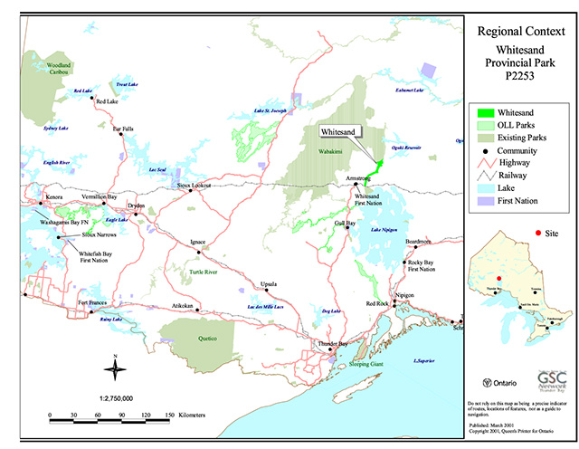
Enlarge regional context map of Whitesand Provincial Park P2253
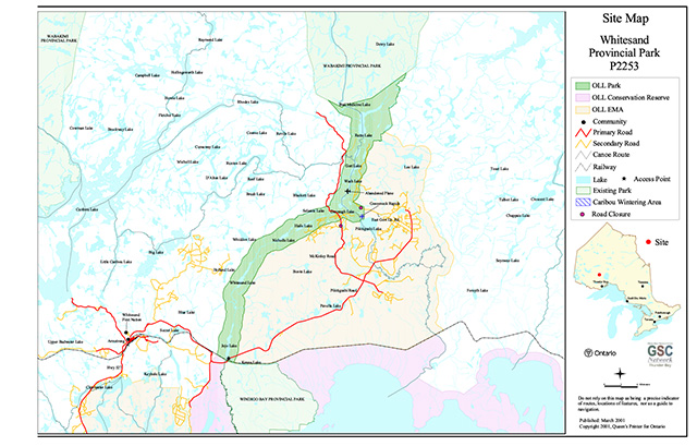
Site Map of Whitesand Provincial Park P2253
Enlarge site map of Whitesand Provincial Park P2253
Regional context of Whitesand Provincial Park P2253

Enlarge regional context map of Whitesand Provincial Park P2253
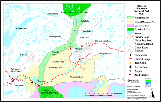
Site Map of Whitesand Provincial Park P2253