Winnange Lake Provincial Park Management Statement
This document provides policy direction for the protection, development and management of Winnange Lake Provincial Park and its resources.
1985 Government of Ontario
Additional copies of this publication are available from the Dryden District Office, P.O. Box 730, Dryden, Ontario P8N 2Z4
February, 1986
Regional Director’s approval statement
This Interim Management Statement will provide interim direction for the management of the Winnange Lake Provincial Park until a comprehensive Park Management Plan is prepared.
This statement will provide the basis for the subsequent preparation of the Park Management Plan.
I am pleased to approve this Interim Management Statement for the Winnange Lake Provincial Park.
Signed by:
D.R. Johnston
Regional Director
Northwestern Region
Introduction
The purpose of this Interim Management Statement is to identify:
- park values which are to be protected
- resource management prescriptions necessary to protect these values; and
- restrictions on use of natural resources within the park
This Interim Management Statement is not intended to replace a Park Management Plan. Rather it is intended to guide the use of natural resources and related activities within the park until such a time as a Park Management Plan is prepared.
The guidelines that have been developed are based on information contained in the Dryden District Land Use Guidelines.
Background information
| Name: | Winnange Lake |
|---|---|
| Proposed Class: | Natural environment |
| M.N.R. District: | Dryden |
| M.N.R. Region: | Northwestern |
| Total Area (ha) | 4745 |
| Land: | |
| Water: | |
| Site Region: | 4-S |
| Site District: | 4-5 |
| Date in regulation: | 85.05.30 |
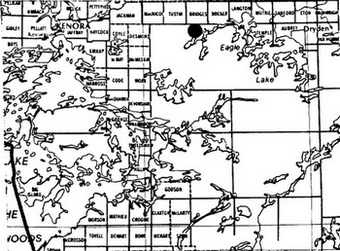
Regional setting map of Winnange Lake
Targets
1 Life science representation
| site type/ landscape unit | species/ communities |
|---|---|
|
|
2 Earth science representation
| geological theme | feature |
|---|---|
|
|
3 Cultural resource representation
| theme | theme segment |
|---|---|
| unknown | unknown |
4 Recreation opportunities
| day use | car camping | wilderness/backcountry |
|---|---|---|
| 14,000 (undeveloped) | 39,000 (undeveloped) | n/a |
Inventories
| level/type | earth science | life science | cultural | recreational | other |
|---|---|---|---|---|---|
| reconnaissance completion date | 1979 | 1980 | 1979 | n/a | |
| detailed completion date | |||||
| required? | yes | yes | yes | yes |
Management guidelines
I. Land tenure
Trans-Canada Pipeline has a right-of-way easement through the access corridor parallel to Hwy. 17.
There are two (2) Crown Reserves on the northeast side of Winnange Lake.
There is a Land Use Permit to Ontario Hydro for a transmission line through the access corridor parallel to Hwy. 17.
Guidelines:
Crown Reserves will be incorporated within the park boundary.
Further requests by Ontario Hydro for additional transmission lines will be allowed through the park access corridor, subject to negotiation. The present easement will continue and further requests for additional pipeline easements will be permitted through the park access corridor, subject to negotiation.
No further requests for land tenure will be considered pending completion of a park management plan.
II. Land acquisition/disposition
The Canadian Pacific Railway has a ballast pit within the access corridor of the park next to Hwy. 17.
There is a C.P.R. spur and mainline on railway property which cuts through the access corridor.
Guideline:
There will not be any attempt to purchase or acquire any of the above properties pending the completion of the park management plan.
Any further requests for railway right-of-way for spur lines, additional mainlines etc. will be approved, subject to negotiation with the railway.
III. Existing/proposed development
There are no existing facilities at present. Any proposed development hinges on the future of Aaron Provincial Park, or consideration of public demand.
There is no road access to the area at present.
Guidelines:
No development will take place until a park management plan is prepared; the future of Aaron Park has been resolved; or the need for additional recreational opportunities are identified within the District.
Road access will not be permitted except for mineral exploration/extraction purposes under the strict guidance of an exploratory licence of occupation.
IV. Recreation activities
Sport fishing and hunting, canoeing, boating and wildlife viewing are presently ongoing recreational activities within the park area. The park area is presently well-utilized for both bear and moose hunting.
Guidelines:
The above recreational activities, with the exception of sport hunting, will be permitted to continue and will be further addressed within the park management plan. Sport hunting is not permitted within the park area
Existing private recreational boat caches will be permitted to continue but the Ministry will not consider any form of land tenure (ie. - Land Use Permits) for those boat caches within the park boundary pending the completion of a park management plan.
V. Commercial activities
Trapping, bait fishing, mineral resources exploration/extraction, timber harvesting, and commercial boat caches are presently ongoing activities. There is no known wild rice harvesting occurring in this area and no commercial
Bait Fishing: There is one commercial bait fish licence within the park area.
Commercial Boat Caches: There are nine (9) commercial boat caches and one (1) resource user boat cache within the park area.
Timber Harvesting: This area is part of G.L.F.P. licence area and also the Kenora Crown Management Unit. There was some cutting on the northwest edge of the Candidate Park area from 1979-81. The area is included within the 20-year management plan, ending in 1991. There is no cutting approved in the present 5-year operating plan (G.L.F.P.) for the park or for the Kenora Crown Management Unit portion of the park.
Mineral Exploration/Extraction: C.P.R. have a ballast pit as previously mentioned. There are no other mining operations at present. The area is open to exploration.
Guidelines
Existing trapping activity will be permitted to continue but new trapline cabins or the relocation of existing trapline cabins will not be allowed pending the completion of a park management plan.
Existing bait fishing operations will be permitted to continue.
No new commercial boat caches will be permitted. Existing commercial boat caches will be permitted to remain and will be further addressed during the preparation of the park management plan.
Commercial timber operations will not be permitted within the the park area. An Order-in-Council will be prepared to formally withdraw the park area from the above licence areas.
Mineral exploration/extraction will be permitted to continue as per the Dryden District Land Use Guidelines. This activity will only be authorized by the issuance of an Exploratory Licence of Occupation under Section 190 of the Mining Act.
VI. Natural resources
Guidelines
Natural fires will be allowed to burn undisturbed unless they threaten human life, lands outside the park, or values for which the park was established. Fires resulting from human causes will be suppressed. Fire suppression techniques used will have as minimal effect as possible on the park environment. Such means of suppression as bulldozing and water bombing with chemical additives will not be permitted except in critical situations.
Management of wildlife will be directed to the maintenance of evolving natural communities unless alternative strategies are desirable.
Management of vegetation will be directed to the maintenance of an evolving natural succession unless alternative strategies are desirable.
Fisheries will be managed and encouraged to an extent capable with the maintenance of a healthy endemic fish population.
VII. Client services
There are none at present other than published canoe routes for Dryden District which include portions of the park area.
VIII. Native interests
There are no known Native interests or claims.
IX. Cultural resources
There are no known cultural resources.
X. Research
More complete earth and life science inventories will be necessary prior to the preparation of a park management plan.
A lake survey will be required on Winnange Lake prior to the preparation of the park management plan.
Sources
Davies, J.C. and Pryslal, A.P., 1965 - Lake of the Woods Sheet, Districts of Kenora and Rainy River, Ontario Department of Mines, Prelim. Geol. Map, P. 281, Geol. Comp. Ser., scale 1 in. = 2 mi.
Kor, P., 1979 - Earth Science Reconnaissance of the Proposed Winnange Prov. Pk.
Noble, T., 1980 -Life Science Reconnaissance of the Proposed Winnange Prov. Pk.
O.M.N.R., 1978 - Report of the Task Force on Parks System Planning
O.M.N.R.1 1981 - Regional Parks System Plan
O.M.N.R., 1983 - Dryden District Land Use Guidelines
Zoltai, S.C., 1961 - Glacial History of Park of Northwestern Ontario. Proc. Geol. Assoc. Can., V13, pg. 61-83 1965 - Map S165
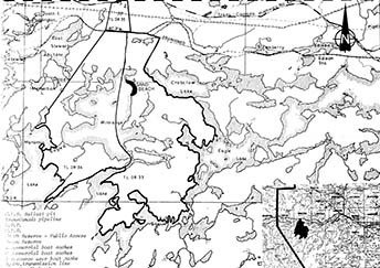
Map of Winnange Lake
13. Winnange Lake area
a. Area description
This area is located immediately south of Highway 17, in the East Stewart Lake, Winnange Lake and Crabclaw Lake area. The area forms part of the Great Lakes Forest Products' licence area and the Kenora Crown Management Unit. The area has a high quality sand beach located on Winnange Lake. Resource activity consists primarily of some timber harvesting, bait fishing, sport fishing, trapping, hunting and Crown land recreation. This area is approximately 4450 hectares in size.
b. Land use intent
This area is being recommended for park status. It will provide a minimum of 14,000 day use opportunities and 39,000 car camping opportunities. Given the variety of uses that are presently ongoing within this area, it is recommended that most activities within the area be permitted to continue. The exception would be commercial logging which is not recommended as a continuing use. An outline of ongoing activities which are recommended for continuation is given in the Land Use Activity section, however it must be realized that in some instances further refinement may be required.
c. Land use activity for area no. 13 - Winnange Lake area
| Activity | Acceptable? | Recommended guidelines |
|---|---|---|
| Aggregate Extraction | No | |
| Agriculture | No | |
| Bait Fishing | Yes | It is recommended that existing bait fishing operations be permitted to continue. |
| Commercial Fishing | No | |
| Cottaging | No | |
| Forestry | No | |
| Hunting | No | |
| Mining | Yes | It is recommended that mineral exploration/ extraction be permitted. |
| Provincial Parks | Yes | The area is recommended for park status. |
| Roads | No | |
| Rural Residential | No | |
| Sport Fishing | Yes | It is recommended that sport fishing be permitted to continue. |
| Tourism | No | |
| Trapping | Yes | It is recommended that existing trapping activity be permitted to continue. |
| Wildlife Viewing | Yes | |
| Wild Rice Harvesting | No | There is no wild rice harvesting presently occurring in this area. |
| Urban Development | No |
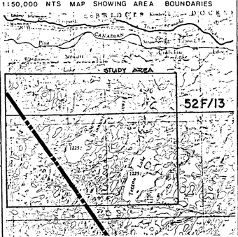
Ontario nature reserves program – Life science inventory checksheet
| Name | Winnange-Teggau Lakes |
|---|---|
| Map Name | Feist Lake; Dryberry Lake |
| Map Number | 52F/13; 52F/12 |
| UTM Ref. | 500110 |
| County, District or Regional Municipality | District of Kenora |
| Lat. | 49 44'N |
| Long. | 93 43'W |
| Alt Min. | 371m |
| Alt. Max | 490+ m |
| Township | |
| Lots | |
| Concessions | |
| Area (acres) ha | |
| Ownership | Crown |
| Administration | Ministry of Natural Resources |
| Forest Region and District | L.11 – Quetico |
| Site Region and District | 4S-5 (Manitou) |
| MNR Region and District | NWR – Dryden |
| Conservation Authority | |
| Aerial Photographs year-roll-flight line-numbers |
Base map: 497933/496933 |
Map showing area boundaries
Physical and biological features
Because of an excellent sand beach on Winnange Lake, the area was considered to have recreational potential for park purposes. Consequently, the surrounding area was briefly looked at in this reconnaissance survey for its representational value. The area looked at includes three biophysiographic units as identified in this study:
Ia-2 moderately broken sandy till (bedrock)
VIIa-3 moderately broken wave-washed bedrock (sandy till)
VIIa-4 moderately broken wave-washed bedrock (lacustrine clay, sandy till).
Extending the boundary to the east towards Delano Lake would also take in an additional unit:
VIIa-7 strongly broken wave-washed bedrock (sandy till).
These units would contribute to site type, plant community and species representation typical of bedrock-controlled sandy till and wave-washed bedrock. The relationship between fire, vegetation and landform is well-illustrated here as the area has a very short fire cycle.
Although the area has excellent representation potential, these same units can be represented elsewhere in the site region, e.g. Turtle River, Woodland Caribou.
Data sheets attached
Physical descriptions
Vegetation summary
Evaluation sheet
Community descr.
Community comp. lists
Summer species lists
Physical features map
Vegetation map
Bibliography
Photographs
Major information sources
Evaluation and priorities
This area has representation potential.
Date compiled: March 31, 1980
Compiler: T. Noble
Map showing Winnange-Teggau Lakes
Biophysiographic representation
Ia-2 – moderately broken sandy till (bedrock)
VIIa-3 – moderately broken wave-washed bedrock (sandy till)
VIIa-4 – moderately broken wave-washed bedrock (lacustrine clay, sandy till)
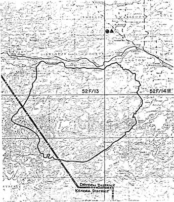
| Name | Winnange-Teggau Lakes |
|---|---|
| Map Name | Feist Lake; Dryberry Lake |
| Map Number | 52F/13 52F/12 |
| UTM Ref. | 500110 |
| County | |
| Lat. | 49 44' |
| Long. | 93 43' |
| Alt Min. | 371m |
| Alt. Max | 490+ m |
| Township | |
| Lot | About 58 km E. of Kenora and 54 km W. of Dryden, as the crow flies. |
| Concessions | |
| Area (acres) ha | |
| Ownership | Crown |
| Administration | |
| MNR Region and District | NWR – Dryden |
| Conservation Authority | |
| Aerial Photographs - Basemaps Year-Roll-Flight line-Numbers |
1965-6-4933-218-232 1965-56-4932-26-40 1965-14-4931-25-39 1965-19-4930-165-181 1965-66-4929-54-70 1965-53-4928-9-25 |
Map showing area boundaries
Earth science features
- acid intrusive igneous bedrock lying within the Wabigoon belt.
- stony sand till and minor pockets of lacustrine sediments discontinuously overlying a bedrock-controlled upland that has been extensively wave-washed by glacial Lake Agassiz.
Sensitivity
- very low to most uses.
Significance
- good example of wave-washed bedrock.
- relatively uncommon (for this area) well-developed sand beach.
Major references
Date compiled: 20 December 1979
Compiler: P. Kor
Physical features:
A large area encompassing Manomin, Winnange and Teggau Lakes was surveyed on a reconnaissance level in order to determine the potential contribution of the earth science features to the protection objective of the Earth Science Framework. Two fixed-wing aircraft flights over parts of the area supplemented the air photo review and the literature search. One landing at the north end of Winnange Lake allowed a closer look at the major beach there.
The Winnange-Teggau Lakes area encompasses a rugged topography of bedrock knolls and ridges with intervening lakes and swamps. The highest point occurs about 4 km south of Feist Lake (UTM 382122), a rock ridge trending northeast-southwest which rises to over 490 m a.s.l, or 120 m above Winnange Lake. Lakeshores are commonly steep or rugged, with abrupt breaks-in-slope a common feature of the area. The bedrock has not been mapped in detail, but it is reported to be predominantly granitic in composition, with possible rock types including strongly foliated gneiss, migmatite, and rocks containing abundant inclusions of metavolcanics or metasediments or both (Davies and Pryslak, 1965}. The study area lies within the Wabigoon Greenstone belt of the Superior Province, Canadian Shield.
The surficial deposits of the area are thin, discontinuous, and commonly non-existant. They consist predominantly of sand till deposited by the Patrician glaciers during the North Bay Interstadial roughly 11,000 to 11,500 B.P. This corresponds to Zoltai’s (1961, fig. 2) description of the area as "moderately rolling shallow till over bedrock Zoltai (1965, May S1651 notes that directly east of Winnange Lake, the generally bare, probably wave-washed bedrock terrain contains pockets of lacustrine clays and silts. These lacustrine deposits probably form the origin of the numerous small sand beaches in the northern basin of Winnange Lake, as: lacustrine sands were doubtlessly associate with the clays and silts. The largest of these beaches occurs in the very northeastern most bay of Winnange Lake (UTM 512162), a 500 m long, 10 m wide open sand beach with a fairly deep, flat, sand backs ore. Steep bedrock knolls surround this beach area.
The lacustrine deposits and large areas of wave-washed bedrock are representative of processes acting during the height of glacial Lake Agassiz. The study area was probably immersed in glacial Lake Agassiz for much of the time following the ice recession. Much of the high bedrock may have been above the water level or just below it, making it susceptible to denudatjon by wave action. A large area was so affected, from Eagle Lake west to the north end of Lake of the Woods (Zoltai, 1965, Map 5165). The lacustrine sediments in the study area probably represent the western limit of deposition within the Wabigoon River basin.
Significance:
The Winnange-Teggau Lakes area encompasses a fairly uniform, broken terrain of rock knolls and intervening wet depressions. The distinctly wave-washed bedrock is not well-represented in the parks system of Northwestern Region. Beaches of the quality exhibited by the Winnange Lake beach are not common between Lake of the Woods and Eagle Lake. Thus, the Winnange-Teggau Lake area, or at least the northern portion of it (Winnange Lake), would contribute to the representation of these elements of the Earth Science Framework.
The bedrock geology is virtually unmapped, so its contributions to the Earth Science Framework can only be guessed at. If the area is indeed underlain by relatively homogenious acid intrusive rocks (Davos and Pryslak, 1965), than the study area has little bedrock significance, as acid intrusive rocks may be represented at sites which require much less land area (outcrop size) and which are more accessible (roadside outcrops). It is emphasized that individual features of unique origin or mineralogy may exist but cannot be accounted for here. The status of the study area may change as the detail of the geological mapping increases.
The southern and western portions of the study area have been burned and logged respectively, reducing the significance of these areas somewhat. Both activities exposes the underlying soils to the elements and increases the chance of their erosion.
Recommendations:
The Winnange Lake area can contribute to those elements of the Earth Science Framework described above. Representation would be adequate, but may not necessarily be the best available as can be determined by the present level of this survey and the existing level of mapping. It is recommended that the Winnange Lake area be considered in any future evaluations of potential park areas.
References:
Davies, J.C. and Pryslak, A.P., 1965. Lake of the Woods Sheet, Districts of Kenora and Rainy River. Ont. Dept. Mines, Prelim. Geol. Map P.281, Geol. Comp. Ser., scale 1 in. equals 2 mi.
Zoltai, S.C., 1961. Glacial history of part of northwestern Ontario. Proc. Geol. Assoc. Can., V.13, p.61-83.
Additional Information: (November 1980)
An eastward expansion of the Winnange-Teggau Lakes candidate area is being proposed for recreational purposes. Such as expansion would add very little to the earth science component of the protection objective. Wave-washed terrain, areas of thin till over bedrock and a dominantly granitic bedrock component, the major landscape units in the original study area, continue to dominate the revised study area. From an earth science point of view, an area of the size proposed here is not required to adequately represent the landscape features; a smaller area would adequately provide representation and protection.
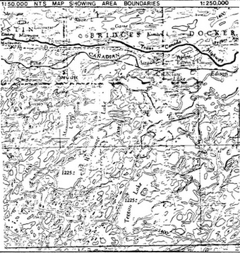
Alternate study area boundary (summer 1980), Winnange-Teggau candidate area. Scale 1:250,000
Enlarge Alternate study area boundary (summer 1980), Winnange-Teggau candidate area. Scale 1:250,000
Map
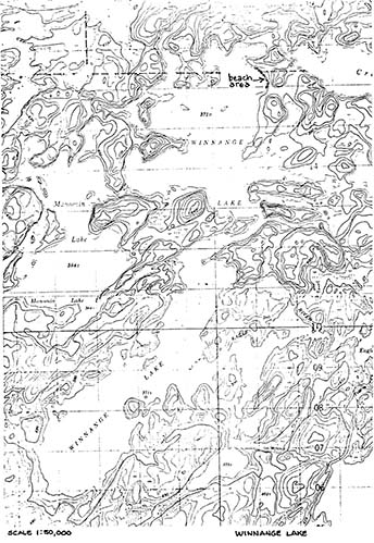
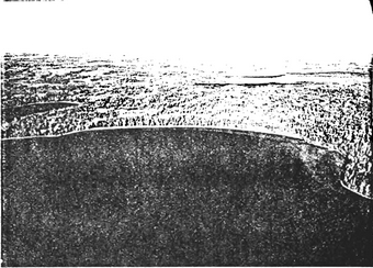
North end of Winnange Lake, looking NE. Beach at UTM 51216.
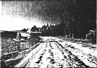
Ground view of beach at UTM 512162, Winnange Lake.
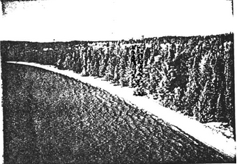
Beach on Winnange Lake. UTM 512162
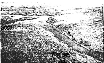
Burn area near Teggau Lake, showing thin till over bedrock.
View of bedrock ridge behind main beach area, looking westward to Winnange Lake.
