W.J.B. Greenwood Provincial Park Management Statement
This document provides policy direction for the protection, development and management of W.J.B. Greenwood Provincial Park and its resources.
© 2009, Queen’s Printer for Ontario
Electronic copies of this publication are available at:
http://www.ontarioparks.com/english/wjbg_planning.html [Link no longer active]
A print version of this publication may be requested from the Finlayson Point Provincial Park office or the Latchford Municipal Office.
Finlayson Point Provincial Park
P.O. Box 38
Temagami ON
P0H 2H0
Telephone: (705) 569-3205
52173
(0,1k 30/09/08)
ISBN 978-1-4249-6871-8 (Print)
ISBN 978-1-4249-6872-5 (PDF)
Printed on recycled paper
Cette publication est egalement disponible en frangais. http://www.ontarioparks.com/frenctl/wjbg_planning.html [Link no longer active]
Dear Sir or Madam,
I am pleased to approve the W.J.B. Greenwood Provincial Park Management Statement as Ontario Parks' policy for the management and development of this park. This management statement reflects the Ministry of Natural Resources' intent to protect the park’s features and values while maintaining and enhancing high quality opportunities for outdoor recreation and cultural heritage appreciation.
The management statement contains policies relating to resource management, operations, and development that will guide the management of W.J.B. Greenwood Provincial Park over the next 20 years.
I would like to express my appreciation to all those who participated Tn the planning process. Your valuable ideas have assisted in the completion of this plan.
Sincerely,
The Honourable Donna Cansfield
Ontario Minister of Natural Resources
Date: March 4, 2009
Statement of environmental values
The Ministry of Natural Resources' Statement of Environmental Values (SEV) under the Environmental Bill of Rights (EBR) describes how the purposes of the EBR are to be considered whenever decisions are made in the Ministry that might significantly affect the environment. This includes decisions made as a result of preparing management direction for a protected area.
The Ministry’s SEV has been considered throughout the planning process. The management direction for W.J.B. Greenwood Provincial Park will further the objectives of managing Ontario’s resources on an environmentally sustainable basis.
1.0 Introduction
1.1 Ontario’s protected areas system
The overall goal of Ontario Parks is to permanently protect a system of provincial parks and conservation reserves that includes ecosystems that are representative of Ontario’s natural regions. Provincial parks protect provincially significant elements of Ontario’s natural and cultural heritage, maintain biodiversity and provide opportunities for compatible, ecologically sustainable recreation.
The planning and management of provincial parks is guided by two key principles within the Provincial Parks and Conservation Reserves Act:
- Maintenance of ecological integrity shall be the first priority and the restoration of ecological integrity shall be considered.
- Opportunities for consultation shall be provided.
The Ministry of Natural Resources (MNR) is responsible for managing Ontario’s natural resources in accordance with the statutes it administers. As the province’s lead conservation agency, the Ministry is the steward of provincial parks, conservation reserves, natural heritage areas, forests, fisheries, wildlife, aggregates, fuel, minerals, and Crown lands and waters that make up 87% of Ontario.
This management statement has been prepared consistent with direction contained in Our Sustainable Future: Ministry of Natural Resources Strategic Direction (OMNR 2005a). The park will be managed consistent with direction in Protecting What Sustains Us: Ontario’s Biodiversity Strategy (OMNR 2005b).
The W.J.B. Greenwood Management Statement has been developed in accordance with Ontario Provincial Parks: Planning and Management Policies (OMNR 1992a) and direction outlined in the Temagami Land Use Plan (OMNR 1997). In accordance with the management statement, MNR will amend affected area-specific land use policies and mapping found in the Crown Land Use Policy Atlas.
This management statement will guide the management, development, and operation of W.J.B. Greenwood Provincial Park over the next 20 years. The management statement may be reviewed or amended as the need arises; Section 13.0 describes the process for the review and amendment of this management statement.
1.2 W.J.B. Greenwood Provincial Park
W.J.B. Greenwood Provincial Park is a 465-hectare recreational class park located within the Municipality of Latchford, 130 kilometres north of North Bay. The park is situated along the southern shores of Bay Lake, a reservoir on the Montreal River. The park is in the Temagami area, an internationally recognized ecotourism and outdoor recreation destination (Figure 1).
W.J.B. Greenwood Provincial Park was named in honour of the late Ben Greenwood, who served as Ontario’s first Chief of Parks from 1954 to 1960. Regulated as a provincial park in 1985, an interim management statement was approved for the park in 1986 (OMNR). The interim management statement directed that no park development would take place until recreational demand increased or until more detailed planning was undertaken.
In 1997 the Temagami Land Use Plan was completed by the MNR. Through this planning process, which included full public and Aboriginal consultation, the land use intent for W.J.B. Greenwood Provincial Park was identified as follows: "to protect an early succession birch dominated forest and provide walk-in camping and hiking with minimal capital infrastructure supported by partnerships with cooperating associations."
The stewardship and development of the park will complement tourism along this segment of the Highway 11 corridor. This management statement proposes limited infrastructure to support a small number of hike-in and boat-in campsites and a small day-use area. Highway travellers and touring vacationers can stop here to enjoy a low intensity recreational experience and other local attractions through day trips.
1.3 Aboriginal context
For over 6,000 years, Aboriginal people have lived in the Temagami area, travelling the interconnected system of winter and summer trails and portages. W.J.B. Greenwood Provincial Park lies within n' Daki Menan, the ancestral homeland of the Teme-Augama Anishnabai - the deepwater people. Many sacred sites are found within the area, and the landscape of Temagami continues to hold great cultural, spiritual and economic significance for First Nation communities. A strong tradition of stewardship continues today through ceremonies, culture, and language, and the spirit of the land is cared for by the original keepers of the land.
The Temagami First Nation continues to express an interest in the planning and implementation of the management statement and is sharing its knowledge by participating on the planning team.
Any communications and cooperation between the Temagami First Nation and MNR for planning and operations purposes are mutually understood to be undertaken without prejudice to any ongoing or future discussions or negotiations between the government of Ontario and the Temagami First Nation.
Nothing in this management statement shall be construed so as to abrogate or derogate from the protection provided for the existing Aboriginal or treaty rights of the Aboriginal people of Canada as recognized and affirmed in section 35 of the Constitution Act (1982).
2.0 Park classification
Ontario’s provincial parks are organized into broad classes or categories, each of which has particular purposes and characteristics. All of Ontario’s provincial parks fall into one of six classes: Wilderness, Nature Reserve, Cultural Heritage, Natural Environment, Waterway, or Recreational. Each class contributes differently towards the provincial park system while collectively ensuring that the province’s natural, cultural, and recreational environments are protected.
W.J.B. Greenwood Provincial Park is classified as a recreational class park. As described in the Provincial Parks and Conservation Reserves Act, recreational class parks "provide a wide variety of compatible outdoor recreation opportunities in attractive surroundings."
Figure 1: Regional Context
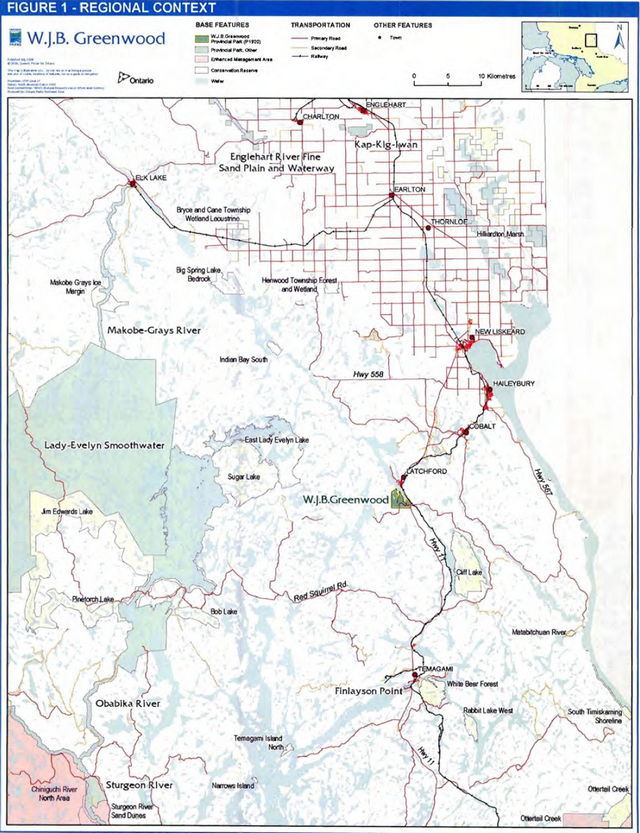
Enlarge Figure 1: Regional Context
2.1 Park goal
The goal of W.J.B. Greenwood Provincial Park is to protect its biological diversity, special beauty, and educational potential while providing a range of day-use and backcountry overnight opportunities.
2.2 Park system objectives
Ontario’s provincial park system has four objectives as stated in the Provincial Parks and Conservation Reserves Act:
- To permanently protect representative ecosystems, biodiversity and provincially significant elements of Ontario’s natural and cultural heritage and to manage these areas to ensure that ecological integrity is maintained.
- To provide opportunities for ecologically sustainable outdoor recreation opportunities and encourage associated economic benefits.
- To provide opportunities for residents of Ontario and visitors to increase their knowledge and appreciation of Ontario’s natural and cultural heritage.
- To facilitate scientific research and to provide points of reference to support monitoring of ecological change on the broader landscape.
W.J.B. Greenwood Provincial Park will contribute to these objectives by providing sustainable and compatible low-intensity recreational opportunities while ensuring that the park’s ecological integrity is maintained.
3.0 Park boundary
W.J.B. Greenwood Provincial Park lies mostly within the Municipality of Latchford, with the northern-most point of the park lying in Coleman Township (Figure 2). The park was regulated in 1985 (O. Reg. 493/85) and encompasses 465 hectares.
The park boundary is delineated by natural and cultural features as well as vectored or straight line limits. The northern boundary follows the water’s edge of Bay Lake, a flooded section of the Montreal River. This boundary, which extends south into both Sucker Gut and Gilchrist bays, is approximately eight kilometres in length. The eastern boundary of the park (one and a half kilometres in length) abuts the Highway 11 right-ofway. A small section of the park’s northeastern boundary borders private land and follows blocks 29 and 39 of the formerly unorganized Gilles Limit Township (now the Town of Latchford). The northwestern boundary follows the border with Coleman Township for approximately 800 metres. The southern and western boundaries are vectored and do not follow any noticeable landmarks.
Provincial park policies apply only to the area within the regulated boundary. Within the park, the protection of values and features will be achieved through appropriate zoning, planned use, education and monitoring of ecological impacts.
The old Fergusson Highway follows a Crown road allowance extending a short distance into the park where it bisects Anima-Nipissing Road. This road allowance is no longer required by the Ontario Ministry of Transportation and will be considered for inclusion within the park boundary through the appropriate transfer process. This process would be in accordance with Environmental Assessment Act requirements and would include a Crown Land Use Policy Atlas (OMNR 2005c) policy report amendment.
Figure 2: Planning Area Boundary
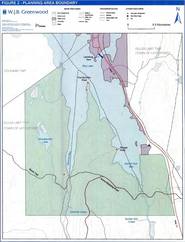
Enlarge Figure 2: Planning Area Boundary
4.0 Adjacent land uses
The Provincial Parks and Conservation Reserves Act, which governs activities within all provincial parks and conservation reserves, pertains only to the lands and waters within the park’s regulated boundaries.
Ontario Parks is committed to an ecosystem approach to park planning and management. An ecosystem approach allows management to consider the relationship between the protected area and the surrounding environment. Managers may consider potential impacts on the park’s values from activities occurring on adjacent lands. Conversely, managers may consider potential impacts from park activities on land uses in adjacent areas. Ontario Parks will co-operate with adjacent land use interests in efforts to maintain the ecological integrity of the park.
The park is entirely encompassed by the boundary of the Municipality of Latchford. The first five-kilometre section of the Anima-Nipissing Road, which lies within the municipal boundaries, is maintained during the non-winter months by the Corporation of the Town of Latchford.
The adjacent forests are managed through the Temagami Forest Management Unit 2004 -2024 Forest Management Plan (OMNR 2004a), with several operations scheduled in the vicinity of the park over the next ten years. A number of mining claims are located to the south and the east of the park. Several aggregate pits occur south of the park along the Anima-Nipissing Road. The Burns Trail, which runs westward through the park, is the remnant of an old logging road. This trail continues to allow trappers. hunters, hikers, and other recreational users access to Crown land west of the park.
The park is situated on Bay Lake, a regulated section of the Montreal River which flows eastward to the Ottawa River. The Latchford Dam, located 500 metres north of the park, is regulated by Public Works Canada. The maximum operational level for Bay Lake is 277.15 metres above sea level; the minimum navigational level is 276.96 metres.
The Corporation of the Town of Latchford operates a public boat launch and a dock, located outside of the park boundary on Bay Lake, which enables park access by water. This facility is scheduled to be upgraded in 2009.
A bed and breakfast establishment operates in Latchford year-round. Several lodges and a trailer park operate in the vicinity of the park from May to October.
A lodge operates from May to October on Anima-Nipissing Lake, 5 kilometres southwest of the park. Private cottages located on Anima-Nipissing Lake are accessed by AnimaNipissing Road, which passes through the park.
5.0 Park values
5.1 Life science
The park lies wi1hin the Great Lakes-St. Lawrence Forest/Boreal Forest transition zone. A large portion of the park consists of early successional white birch- (Betula papyrifera) and aspen- (Populus sp.) dominated forest. The second-growth forest seen on Sucker Gut Peninsula provides evidence of recent logging activity. Stands of white pine (Pinus strobus) and red pine (Pinus resinosa) are scattered throughout the park. The red pine stands dominating on the esker fragment at Woodpecker Lake are considered to be regionally significant (Morris 2006). Jack pine (Pinus banksinia) occurs on the west side of the park. Red maple (Acer rubrum), yellow birch (Betula alleghaniensis), and sugar maple (Acer saccharum) are found throughout the park.
There are several non-forest and sparsely-treed communities in the park, ranging from conifer swamps, fens, and bogs, to open marsh and exposed rock outcroppings. There is abundant evidence of beaver (Castor canadensis) activity, with most wetlands having been influenced by this species at some point in time.
A total of 166 vascular plant species have been documented in the park. Some of these species. such as marsh fern ( Thelypteris palustris), alternate-leaf dogwood (Comus alternifo/ia), and blue vervain (Verbena hastate), are either rare or undocumented elsewhere within Ecodistrict 4E-4. Areas of local diversity are associated with the Woodpecker Lake area and Sucker Gut Creek.
None of the species observed in the park are species at risk or considered provincially rare.
5.2 Earth science
Surficial deposits within the park are generally thin and characterized as neutral to acidic Precambrian Bedrock. Bedrock generally occurs at or near the surface, although the presence of old borrow-pits indicates scattered occurrences of thicker deposits. A short esker fragment occurs at Woodpecker Lake with developing organic deposits in adjacent depressions. Fluvial or alluvial deposits may be associated with Gilchrist and Sucker Gut creeks. Glacial erratics are also found scattered throughout the park. Collectively, the earth science features in the park are considered to be locally significant.
5.3 Cultural heritage
The park is located on Bay Lake of the Montreal River, opposite the town of Latchford, a significant lumber-producing community of the early 20th century. Bay Lake is a managed water body; the Latchford Dam is located immediately west of the Sgt. Aubrey Cosens Memorial Bridge at Latchford. In the 1900's, the Montreal River was an important transportation route with travel being primarily by canoe and steamboat. The use of steamboats on the Montreal River increased greatly as prospectors headed to Elk Lake for mining exploration.
Historical evidence of logging and associated activities such as log-booming can be found in the park, including artifacts such as iron rings and log cribs. The Burns Trail, which traverses the park, was originally constructed as a logging road and crosses the site of a 1906-era logging camp at the mouth of Gilchrist Creek. In the early 1900's, many lumber mills operated in the Latchford area, using Bay Lake to transport logs along the Montreal River.
Once constructed, an information kiosk will be dedicated to James Keenan, a Latchford resident who was a student of, and later a successor to, Ben Greenwood.
5.4 Recreational values
Bay Lake and the Montreal River provide recreational opportunities such as canoeing, kayaking, boating, and fishing for visitors and residents of Latchford. The Burns Trail. traditionally used for logging, is now used tor hiking, photography, wildlife viewing, and nature appreciation. The trail is also used to access areas for hunting, fishing, and trapping. In the winter, the trail Is used for snowmobiling, snowshoeing, and cross-country skiing. Local colleges use the park as a "living laboratory'' to enhance experiential learning.
Ranger Point, the site of a former Ontario Junior Ranger camp, is currently used for camping. Recreation in the park will continue to be directed toward traditional low intensity recreational activities such as hiking, camping, and canoeing. A trail plan for the park will be developed.
J.B. Greenwood Provincial Park will offer visitors access to a variety of day-use trails ranging in difficulty from gentle trails along the shoreline of Bay Lake to more challenging trails in the interior. The park also serves as the trailhead for the 100 kilometre-long Ottawa-Temiskaming Highland Trail.
6.0 Policy context
The following policies apply to the entire park area. Refer to section 11 .0 Zoning and Zone-Specific Management Policies for zone-specific policies that pertain to each individual zone.
6.1 Adaptive management
An adaptive management approach will be applied to resource management activities within the park. Adaptive management allows for the modification of management strategies in response to monitoring and analysis of the results of past actions and experiences. Adaptive management is a systematic and practical approach to dynamic and effective resource management.
7.0 Research, inventory and monitoring
7.1 Inventory and monitoring
Planning and management decisions are intended to protect the ecological integrity of parks. Ontario Parks will ensure that decisions are made by using the best available information. Where information is lacking, Ontario Parks may conduct inventories and monitoring as necessary to acquire this information. Such efforts will be based on established methodologies and best practices. This will support an adaptive management approach to protected areas management.
An assessment of the geological features within the park has not yet been conducted and is therefore an inventory and monitoring priority. Another priority is an evaluation of the snowmobile/ATV crossing of Gilchrist Creek along the Burns Trail. The Burns Trail crossing of Gilchrist Creek is used by local people for hunting and other access purposes. This site will be monitored and evaluated for the ecological impacts of this use.
7.2 Research
Scientific research by qualified individuals that contributes to the knowledge of natural and cultural history or to environmental and recreational management will be encouraged. All research will be either conducted or authorized by Ontario Parks.
Approved research activities and facilities must be compatible with the park’s protection objective or recreational uses and are subject to park management policies and pertinent legislation.
Temporary facilities and any associated dispositions of Crown resources in support of approved research and monitoring activities may be considered. Sites altered by research activities will be rehabilitated as closely as possible to their previous condition.
Potential researchers must submit an application to conduct research in provincial parks to the Ontario Parks Northeast Zone office. An electronic copy of the application form is available at www.ontarioparks.com.
Ontario Parks will encourage the publication and transfer of information and knowledge gained from research and monitoring. Priority will be given to research involving quantitative and qualitative inventories of flora and fauna, species at risk, and monitoring of ecological processes, and recreational use.
The collection of rocks, minerals, archaeological or cultural artifacts, plants, animals, and seeds is permitted only by research permit and, when necessary, a scientific collector’s permit.
8.0 Resource management policies
W.J.B. Greenwood Provincial Park will be managed in accordance with direction for recreational class parks as set out in Ontario Provincial Parks: Planning and Management Policies. The policies in the following sections will guide the management of park resources consistent with the Provincial Parks and Conservation Reserves Act and the Environmental Assessment Act. All projects will be consistent with A Class Environmental Assessment for Provincial Parks and Conservation Reserves (OMNR 2005d).
Planning and management will be consistent with the direction for management statements, defined in the Provincial Parks and Conservation Reserves Act as "a document… that provides a policy and resource management framework that addresses a limited number of non-complex issues or proposals or both for limited capital infrastructure or resource management projects…"
8.1 Land management
There are presently no land patents or leases within the park. The sale or disposition of lands for the private use of individuals or corporation’s (e.g., recreation camp or cottage) is not permitted.
8.2 Industrial/commercial uses and activities
The following uses are not permitted:
- Commercial forestry
- Prospecting, staking mining claims, developing mineral interests or mines
- Extraction of sand, gravel, topsoil or peat
- Commercial hydroelectric power development
- Commercial trapping
- Commercial baitfish harvesting
- Commercial fishing, and
- Commercial food harvesting (e.g., blueberries).
8.3 Non-native and invasive species
The term "non-native species" describes species that are not native to Ontario. Nonnative species will not be deliberately introduced to the park. The term "invasive species" describes species that are likely to spread and negatively affect native ecosystems. Where possible, actions will be taken to eliminate or reduce the threat of the introduction of invasive non-native species. Where non-native species are already established and threaten natural or cultural values, a program of control may be undertaken if feasible and practical.
Invasive species will be monitored and a control. program may be implemented as required.
8.4 Species at risk
There are currently no known species at risk within the park. Species at risk which may be found to occur in the park will be protected consistent with the Endangered Species Act and regulations as well as the Provincial Parks and Conservation Reserves Act and provincial park policies.
8.5 Forest fire management
MNR recognizes fire as an essential ecosystem process, fundamental to restoring and maintaining the ecological integrity of protected areas in the Great Lakes-St. Lawrence Forest/Boreal Forest transition zone. This region includes many fire-tolerant and fire-adapted species. such as birch and jack pine species, found within the park. Fire is considered to be the primary natural disturbance agent responsible for the regeneration of birch stands, as fire creates suitable seed beds and reduces competition, permitting this early successional species to colonize in the open burned areas (Van Sleeuwen 2006).
Forest fire management involves the protection of values and the attainment of resource management objectives through:
- Fire response: the protection of people, property and natural areas from wildfire.
- Fire use: the strategy of maintaining fire as an ecological process or meeting resource management objectives through the application or management of fire.
The Forest Fire Management Strategy for Ontario (OMNR 2004b) provides strategic direction for the management of forest fire across Ontario. W.J. B. Greenwood Provincial Park Is in the Great Lakes-St. Lawrence Fire Management Zone according to this provincial strategy.
Fires will be managed within the park in a manner that will help maintain ecological integrity while preventing personal injury, value loss, and social disruption. Basic fire management principles included in this management statement are in accordance with provincial park directive PM 11.03.03 Developing the Forest Fire Management Section in the Management Direction for Protected Areas (OMNR 2008).
8.5.1 Fire response
Fires that pose a threat to public health and safety, property and infrastructure, or other values will receive a full response and sustained action.
Fire evacuation procedures will be outlined in the park’s Emergency Plan.
Where feasible, "light on the land" fire suppression techniques will be used to minimize impacts or disturbance to natural or cultural values. Examples include:
- limiting the use of heavy equipment
- discouraging the use of foam, and
- limiting the felling of trees during fire response.
8.5.2 Fire use
Prescribed burning is the deliberate, planned, and knowledgeable application of fire by authorized personnel to a specific land area to accomplish pre-determined objectives. Prescribed burning to achieve ecological or hazard reduction objectives may be considered within W.J.B. Greenwood Provincial Park.
A plan for any prescribed burning will be developed in accordance with MNR's Prescribed Burn Policy (in prep.), A Class Environmental Assessment for Provincial Parks and Conservation Reserves, and in cooperation with MNR fire personnel.
8.5.3 Additional direction
Partial or total fire bans may be set in place and enforced at the discretion of the park superintendent following consultation with MNR fire personnel and the local municipal fire department.
Ontario Parks will work with partners to identify any areas where vegetation rehabilitation may be required.
8.6 Wildlife management
Animal populations or individual nuisance animals may be controlled when essential to human health and safety, the health of the species outside the park, or the values for which the park has been established. Where control is necessary, techniques used will have minimal effects on other components of the park’s environment.
There are no bear management areas within the park. New bear management area licenses will not be permitted (OMNR 2000; 2003).
There are no traplines within the park. New operations, including trap cabins and trails, will not be permitted (OMNR 2000; 2003).
The moose population will be monitored by the Moose Management Committee for Wildlife Management Unit (WMU) 40 and the Temagami Area Biologist.
Ontario Parks will work With MNR North Bay District to protect and manage identified important habitat (e.g., moose habitat) and manage animal populations.
8.7 Cultural heritage resources
Ontario Parks, in conjunction with partners such as the Corporation of the Town of Latchford and in consultation with the Ontario Ministry of Culture and local First Nations, may conduct studies to determine the existence of significant cultural resources within the park.
Where a project involves ground disturbance in an area with high potential for terrestrial archaeological resources, the project will be assessed for impacts on those potential archaeological resources. Where a project may impact upon structures (i.e., built heritage resources) or cultural heritage landscapes, the project will be considered for potential effects on those cultural heritage resources and appropriate mitigation measures will be determined and applied. Staff wlll consult the Technical Guideline for Cultural Heritage Resources for Planned Projects Under the Class Environmental Assessment for MNR Resource Stewardship and Facility Development Projects and the Class Environmental Assessment for Provincial Parks and Conservation Reserves (OMNR 2006).
Incompatible recreational activities will be restricted or prohibited where necessary to protect significant cultural heritage resources.
9.0 Operational policies
The park will be operational for day-use activities as well as overnight walk-in/boat in camping.
A park operations plan will be prepared to provide park staff with the necessary direction to operate the park on a day-to-day basis. In addition to operational policies, the plan will include such topics as budget, staffing, maintenance, enforcement, and emergency procedures. Park operations will be carried out consistent with Ontario Provincial Parks Minimum Operating Standards (OMNR 1992b).
9.1 Hunting
Hunting is permitted to continue within the park’s natural environment zone, with consideration for public safety and subject to regulations under the Fish and Wildlife Conservation Act. As the hiking trail system is developed, specific areas may be assessed for hunting restrictions, as required, to ensure public safety.
Hunting is prohibited in the A1 Anima-Nipissing Access Zone, which is a road, the A2
Burns Trail Access ZoneJ which is a well-travelled trail, and the D1 Bay Lake Shoreline Development ZoneJ which is a shoreline. Signs will be posted in these zones and hunters entering the park will be informed of these restrictions.
9.2 Recreational fishing
Recreational fishing is permitted, subject to provincial and federal fisher es regulations as set out in the Ontario Recreational Fishing Regulations Summary.
9.3 Trails
Hiking is permitted on designated trails. If sensitive features are threatened, actions may be taken to mitigate negative impacts or hiking trails may be closed or relocated.
9.4 Camping
Overnight camping is permitted on designated campsites only. Designated campsites will be accessible by walk-in or water access only.
9.5 Non-mechanized travel
Hiking, cross-country skiing, and snowshoeing are permitted. Mountain bikes are permitted on roads within the access zone and in the A2 Burns Trail Access Zone. Mountain bike use is permitted in the A2 Burns Trail Access Zone but not on hiking trails. If there is a demonstrated need, specific trails for mountain bike use may be considered.
9.6 Mechanized travel
Vehicular access:
The Anima-Nipissing Road will serve as the main access into and through the park. Parking lots are permitted along the Anima-Nipissing Road as well as the Ranger Point Road, which will provide vehicular access to the day-use area at Ranger Point.
Access in the A2 Burns Trail Access Zone is restricted to existing motorized use only (i.e., snowmobiles and ATVs). No other motorized vehicles will be permitted in this zone.
Access in the natural environment zone is restricted to hike-in or water access except for the snowmobile trail from Anima-Nipissing Road to Sucker Gut Bay.
Snow mobiles:
Snowmobiling is permitted on two authorized trails only: A2 Burns Trail Access Zone and the existing snowmobile access trail from Anima-Nipissing Road to Sucker Gut Bay.
Snowmobile use on authorized trails may continue as long as sensitive ecological features are not disturbed. Ontario Parks may relocate portions of the existing snowmobile trails to less sensitive areas if required to minimize impacts.
Off-trail snowmobile travel is prohibited.
All-terrain vehicles (ATV):
ATV travel is prohibited within the park except for authorized roads in the A1 Anima-Nipissing Access Zone. ATV travel may be considered in the A2 Burns Trail Access Zone, subject to an assessment of potential ecological impacts of this activity and development of mitigation strategies. Other upgrades to the Burns Trail, including construction of a bridge at Gilchrist Creek, may be required before ATV use of the trail through the park is authorized.
Off-trail ATV travel is prohibited.
Motor boats:
Motorboat access to the park via Bay Lake is permitted on designated campsites or in day-use areas only.
9.7 Geocaching
Virtual geocaching may be considered subject to approval by the park superintendent.. Physical geocaches are not permitted.
9.8 Other recreational activities
Day-use activities such as picnicking and swimming are encouraged at Ranger Point A designated swimming area, identified by buoys and signs, will be developed at Ranger Point.
9.9 Natural heritage education
The goal of the Natural Heritage Education program is to develop visitor awareness and appreciation of Ontario Parks' natural and cultural heritage, fostering a commitment to its protection for future generations. Programming will include the three components of Natural Heritage Education: information, interpretation, and outdoor recreation.
The Natural Heritage Education program will be at the self-use level with interpretive signage and displays along trails and access points. A self-serve information kiosk located on Anima-Nipissing Road will provide information on park features, campsites, and trail networks.
9.10 Partnerships
Ontario Parks may pursue partnership opportunities with other agencies and groups through formal partnership agreements to implement park operations and development. Partners may represent the local community or regional/provincial interests. Partners will work with Ontario Parks to assist with the implementation of the approved management statement and follow provincial park policies and regulations.
Ontario Parks intends to enter into a partnership with the Town of Latchford, where the Town will be the custodial manager of the park following the direction of Ontario Parks and the approved park management statement. The Town of Latchford would play a lead role in developing, operating, and promoting the park.
Ontario Parks and the Town of Latchford may explore partnerships to develop a "Friends of Greenwood Park" group to assist in park management and operations, including Natural Heritage Education opportunities.
Specific partnerships for research, monitoring, and education will be explored with community colleges, local residents and park users. To encourage research partnerships, Ontario Parks and the Town of Latchford will promote the educational role of the park. Local residents, naturalist clubs, and similar groups may be encouraged to assist with monitoring activities.
9.11 Marketing and communications
9.11.1 Marketing
Ontario Parks will collaborate with the Town of Latchford to market recreational opportunities and the natural and cultural values within the park and the surrounding area.
9.11.2 Communications
Volunteers and local partnerships will be encouraged to assist in the production of brochures, maps, web materials, and other written or audio/visual materials on the park’s natural and recreational values. Text related to the provincial park in any promotional materials prepared by partners will require prior approval from Ontario Parks. Such materials will adhere to the policy direction outlined in this management statement.
10.0 Development policies
All development undertaken by Ontario Parks or by partners on its behalf will comply with A Class Environmental Assessment for Provincial Parks and Conservation Reserves and meet site planning and development standards for provincial parks.
Areas proposed for development will be assessed for cultural and natural heritage values to ensure any significant values are identified and protected.
New development projects that may be considered include a network of day-use trails, walk-in and boat-in campsites, a day-use picnic area, parking and road upgrades, vault privies, interpretive signage, and a self-serve information kiosk. Trails will be located and designed to minimize disturbance to sensitive areas while allowing for interpretive opportunities.
A limited number of walk-in and boat-in campsites will be developed along the shores of Bay Lake. There are currently four existing campsites in the park; this number will be increased to a maximum of 30 campsites, dependent upon an assessment of the carrying capacity of the area. To ensure ecological integrity and the protection of sensitive areas, the number and location of campsites will be determined through site assessments. Each campsite will contain a fire installation, tent pads, signage, and access to a box privy. Campsites will be developed based upon site planning and will adhere to Ontario Parks' minimum operating standards.
Signage identifying the significance of park values and the location of designated access sites may be installed. Signs will' be posted restricting motorized and non-motorized vehicle use (e.g., ATVs, snowmobiles, mountain bikes) on designated trails.
11.0 Zoning and zone-specific management policies
Lands within W.J.B. Greenwood Provincial Park are zoned in accordance with their environmental and cultural values and their need for protection. Zones differentiate the sensitivity of the natural and cultural values and the permissible degree of development, recreational uses, and management practices within the park.
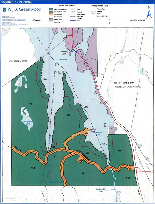
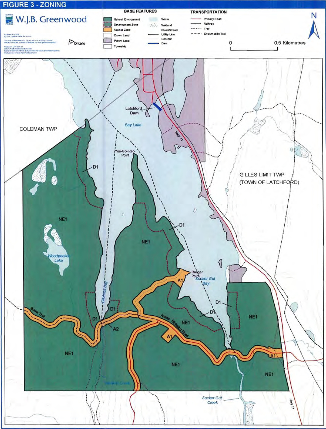
Three zone types are identified in the park: access. development, and natural environment (Figure 3).
Natural Environment zones include natural landscapes which permit the minimum level of development required to support low-intensity recreational activities. Development is generally limited to back-country campsites, portages, necessary signs, and minimal interpretive facilities.
Access zones serve as staging areas and provide for more intensive forms of recreation. Development is generally limited to roads and visitor control structures. Self-use visitor orientation or educational facilities may be provided.
Development zones typically include roads, visitor information structures, day-use areas. and car camping facilities. Within W.J.B. Greenwood Provincial Park, the development zone enables the development of walk-in and boat-in campsites along the shoreline of Bay Lake.
Specific direction for each zone is outlined below. Permitted activities in each type of zone are derived from Ontario Provincial Parks: Planning and Management Policies.
11.1 A1 Anima-Nipissing Access Zone (24 hectares)
Management intent
This zone will provide access, parking, and information to park visitors. Day-use activities are encouraged at Ranger Point. This zone will serve as a staging area for walk-in campsites in the D1 Bay Lake Shoreline Development Zone as well as trailheads for day-use hiking trails in the NE1 Natural Environment Zone.
This access zone includes two existing road corridors within the park. Proposed infrastructure will be limited to roads, parking lots, self-serve information kiosks, and a day-use area with a picnic shelter, a day-use beach, a dock, and vault privies.
Figure 3: Zoning
Policy direction
Motorized vehicles are permitted on authorized roads only. Parking is permitted only In designated areas. Motor boats and canoes are permitted to access day-use facilities at Ranger Point. A marked swimming area adjacent to the day-use area will be defined by buoys anchored to the lake bed.
Hiking, biking, skiing, and snowshoeing are permitted.
Campfires are restricted to designated fire installations in the day-use area. Hunting is prohibited in this zone.
11.2 A2 Burns Trail Access Zone (10 hectares)
Management intent
This zone includes the existing Burns Trail, which is a remnant of an old logging road. This trail is used by local people tor hunting and other access purposes. There will be no other infrastructure in this zone.
Policy direction
Travel by snowmobile is permitted on the Burns Trail. Off-trail travel is not permitted.
Non-winter motorized travel (e.g., ATV use) of the Burns Trail will not be permitted until a suitable crossing of Gilchrist Creek is developed and will be subject to an assessment of potential ecological impacts of this activity and development of mitigation strategies. Off trail travel is not permitted.
All other motorized travel is prohibited.
Hiking, mountain biking, skiing, and snowshoeing are permitted. Hunting is prohibited.
11.3 NE1 Natural Environment Zone (384 hectares)
Management intent
This is the largest zone and serves as the main backcountry recreation area within the park. This zone protects natural landscapes while permitting limited infrastructure such as backcountry trails, signs, and minimal interpretive facilities.
The western portion of the zone includes the regionally significant ecological area in the Woodpecker Lake valley.
Development is limited to the minimum amount of infrastructure required to support low intensity recreational activities. Infrastructure will be limited to day-use interpretive trails, necessary signs, and self-use interpretive information, Trails will be developed only in areas that will not impact ecologically significant features.
Policy direction
Travel by snowmobile is permitted on the access trail that connects the Anima-Nipissing
Road with Sucker Gut Bay. Oft-trail travel is not permitted. All other motorized travel is prohibited.
Hiking is permitted on designated trails only. Hiking trails will be located and designed to minimize the impacts on significant ecological features. Mountain biking on hiking trails or off-trail is prohibited.
Cross-country skiing and snowshoeing are permitted.
Hunting is permitted to continue within the zone, with consideration for public safety and subject to regulations under the Fish and Wildlife Conservation Act. As the hiking trail system is developed, specific areas may be assessed for hunting restrictions to ensure public safety.
11.4 D1 Bay Lake Shoreline Development Zone (42 hectares)
Management intent
This zone encompasses the shoreline along Bay Lake inland to a distance of 100 metres. Development in this zone will be limited to infrastructure associated with walk-in and boat-in campsites; no other development will be permitted. Currently, there are four existing campsites; this number will be increased to a maximum of 30 campsites, dependent upon an assessment of the carrying capacity of the area. The 100 metre setback allows for the location of individual campsites as well as associated backcountry privies, located at a suitable distance inland from water sources.
Policy direction
Camping and overnight docking is permitted at designated sites only with a valid camping permit. Campfires are restricted to fire installations on designated campsites. Motor boats and canoes are permitted to access docks at the day use area and at designated campsites along the shoreline.
Walk-in access to campsites will be via a proposed hiking trail network that will be developed in the NE1 Natural Environment Zone. Boat-in access is via Bay Lake (Montreal River), which is outside of the park boundary.
Motorized land vehicles are not permitted.
A limited number of campsites may be considered along the shoreline of Bay Lake if site planning determines that they will not impact upon sensitive features.
Hunting is prohibited in this zone.
12.0 Implementation priorities
This section contains a summary of priorities that will be implemented by Ontario Parks, in conjunction with partnerships, upon the approval of the park management statement.
Park development, operations. and resource stewardship will be contingent upon the availability of funding and any changes in priorities or policy.
Park operations and development shall meet the requirements of the Environmental Assessment Act, the Environmental Bill of Rights, the Provincial Parks and Conservation Reserves Act, the Endangered Species Act, and other pertinent legislation. All projects will be undertaken in accordance with the requirements of A Class Environmental Assessment for Provincial Parks and Conservation Reserves.
Implementation priorities include the following projects:
Partnerships and planning:
- Develop one or more partnership agreements.
- Develop a park business plan.
- Develop a Park Operating Plan and Park Emergency Plan.
Roads and access:
- Upgrade and maintain 0.8 km Ranger Point road to enhance access and service the day use area.
- Develop parking and trailhead information, information kiosk, and road signage.
- Develop park entrance signs.
Trails:
- Assess the 2 km section of Burns Trail within the A2 Burns Trail Access Zone for an upgrade (which may include bridge construction at Gilchrist Creek) to enable
- A TV access through the park in an environmentally sensitive manner, or maintain it as a walking/snowmobile trail only.
- Develop a day-use hiking trail system In the NE1 Natural Environment Zone and associated trailheads or staging areas in the A1 Anima-Nipissing Access Zone.
Campsites:
- Assess and develop hike-in/boat-in campsites in the D1 Bay Lake Shoreline Development zone; construct associated infrastructure (e.g., tent pads, fire installations, privies, signage, etc.).
- Construct docks for boat-in sites where required.
Day-use facilities:
- Construct picnic shelter, change room, vault toilets, a dock, and a tool shed,
- Develop day-use beach area and designated swimming area.
- Develop parking and garbage facilities and information signs.
Park boundary:
- Regulate road allowance on the old Fergusson Highway into the park boundary.
13.0 Amendment and review of this management statement
This management statement is the proposed direction tor the resource management, development, and operation of W.J.B. Greenwood Provincial Park. This management statement will provide park management direction tor the next 20 years.
A management statement can be reviewed or amended to address changing issues or conditions. In 10 years, this statement will be examined for the need for a review m amendment. A review may involve a reassessment of all or part of the statement, including classification, zoning, goal, objectives, and all resource management, development, and operational policies. An amendment can be considered to address specific changes or needs.
14.0 References
Constitution Act. (1982). Endangered Species Act, 1990.
Environmental Assessment Act, 1990.
Fish and Wildlife Conservation Act, 1997.
Freedom of Information and Protection of Privacy Act, (1990).
Morris, E., 2006. W.J.B. Greenwood Provincial Park: Life Science Checksheet.
Ontario Ministry of Natural Resources,1986. W.J.B. Greenwood Provincial Park Interim
Management Statement. Queen’s Printer for Ontario.
Ontario Ministry of Natural Resources, 1992a.Ontario Provincial Parks Planning and Management Policies.
Ontario Ministry of Natural Resources, 1992b. Ontario Parks Minimum Operating Standards.
Ontario Ministry of Natural Resources, 1997. Temagami Land Use Plan.
Ontario Ministry of Natural Resources, 2000. Ontario’s Living Legacy Land Use Strategy (Policy Clarification).
Ontario Ministry of Natural Resources. 2003. Directions for Commercial Resource Use Activities in Provincial Parks and Conservation Reserves. 5 pp.
Ontario Ministry of Natural Resources, 2004a. Temagami Management Unit 2004 - 2024 Forest Management Plan.
Ontario Ministry of Natural Resources, 2004b. Forest Fire Management Strategy for Ontario. April 2004. Queen’s Printer for Ontario.
Provincial Parks and Conservation Reserves Act, 2006.
Ontario Ministry of Natural Resources, 2005a. Protecting What Sustains Us: Ontario’s Biodiversity Strategy. Queen’s Printer for Ontario.
Ontario Ministry of Natural Resources, 2005b. Our Sustainable Future: Ministry of Natural Resources Strategic Direction. Queen’s Printer for Ontario.
Ontario Ministry of Natural Resources. 2005c. Crown Land Use Policy Atlas. Online: www.crownlanduseatlas.mnr.on.ca
Ontario Ministry of Natural Resources, 2005d. A Class Environmental Assessment for Provincial Parks and Conservation Reserves. Queen’s Printer for Ontario.
Ontario Ministry of Natural Resources, 2006. A Technical Guide for Cultural Heritage Resources for Planned Projects Under the Class Environmental Assessment for MNR Resource Stewardship and Facility Development Projects and the Class Environmental Assessment for Provincial Parks and Conservation Reserves. Queen’s Printer for Ontario.
Ontario Ministry of Natural Resources, 2008. Developing the Forest Fire Management Section in the Management Direction for Protected Areas. PM 11.03.03. July 4, 2008.
Van Sleeuwen, M., 2006. Natural Fire Regimes in Ontario. Queen’s Printer for Ontario.