Woman River Forest Provincial Park Management Statement
This document provides policy direction for the protection, development and management of Woman River Forest Provincial Park and its resources.
Interim Management Statement
2006
Approval statement
I am pleased to approve this Interim Management Statement for Woman River Forest Provincial Park (P1551). Ontario’s Living Legacy Land Use Strategy (OMNR 1999) identified this area as a natural environment class park. Woman River Forest Provincial Park was regulated under the Provincial Parks Act in June of 2003 (O. Reg. 210/03).
This Interim Management Statement provides direction for the protection and custodial management of Woman River Forest Provincial Park.
Signed by:
Paul Bewick
Zone Manager
Northeast Zone
Ontario Parks
Date: May 29, 2006
1.0 Introduction
The Woman River Forest Provincial Park, a 6,322 hectare natural environment class park, is located approximately 60 kilometres southeast of Chapleau and seven kilometres southeast of Sultan (Figure 1).
The park encompasses Woman Lake, which is actually a widening of the Woman River. The park also includes several smaller lakes (Figure 2). Approximately six kilometres of the Woman River are included in the park. The park also contains a broad array of forest and wetland types.
Natural environment parks provide high quality recreational and educational experiences in attractive outdoor settings.
1.1 Objectives
Woman River Forest Provincial Park will be managed consistent with the four objectives for provincial parks:
Protection: To protect provincially significant elements of the natural and cultural landscapes of Ontario.
Recreation: To provide provincial park outdoor recreation opportunities ranging from high-intensity day-use to low-intensity wilderness experiences.
Heritage Appreciation: To provide opportunities for exploration and appreciation of the outdoor natural and cultural heritage of Ontario.
Tourism: To provide Ontario’s residents and out-of-province visitors with opportunities to discover and experience the distinctive regions of the Province.
2.0 Management context
The purpose of this Interim Management Statement (IMS) is to provide direction to ensure the custodial management of park resources. Future park planning may be undertaken as required to provide direction on significant decisions regarding resource stewardship, development, operations and permitted uses.
Park management will follow direction from:
- Provincial Parks Act (1990)
- Ontario’s Living Legacy Land Use Strategy (OMNR 1999) and related policy clarification documents (OMNR 2000)
- Ontario Provincial Parks Planning and Management Policies (OMNR 1992)
- Ontario Crown Land Use Policy Atlas (OMNR 2004a)
In addressing custodial management obligations to protect park values and ensure public health and safety, Ontario Parks will ensure that policy and Environmental Assessment Act (1990) requirements are implemented.
The park superintendent will implement the policies, procedures and legislation that are derived from the above direction and written into this IMS for this park.
2.1 Environmental assessment
As part of the Ontario Ministry of Natural Resources (MNR), Ontario Parks is a public sector agency that is subject to the Environmental Assessment Act. Management of the park will be carried out in accordance with legislation, policies and MNR's A Class Environmental Assessment for Provincial Parks and Conservation Reserves (OMNR 2005).
3.0 Park features and values
Woman River Forest Provincial Park is located in the MNR administrative District of Chapleau.
The park protects diverse forest and wetland representations. The northern half of the park is located in Ecodistrict 3E-5 and the southern half of the park is located in Ecodistrict 4E-3.
Figure 1: Regional Setting
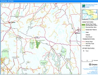
Enlarge Figure 1: Regional Setting
Figure 2: Park Boundary
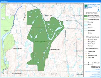
Enlarge Figure 2: Park Boundary
3.1 Geological features
Woman River Forest Provincial Park lies within the 2.75 to 2.67 billion year old western Abitibi Subprovince, in the Superior Province of the Precambrian Shield. Bedrock exposure in the park is generally poor, limited to minor lakeshore outcrops and valley train. The Woman River area is underlain for the most part by Archean granitic gneisses and migmatite batholithic rocks of the Ramsey Gneiss Domain, part of the Ramsey – Algoma granitoid complex, a widespread region of plutonic and gneissic rocks that was emplaced between ~2.70 and 2.68 billion years ago (Frey and Duba 2002).
The surficial deposits of the park are thin sandy ground moraine till, glaciolacustrine fine sand and glaciofluvial ice contact coarse sand and gravel. The till remains on the upland surfaces and in hillside pockets (Frey and Duba 2002).
3.2 Biological features
Woman River Forest Provincial Park is significant for its diverse forest and wetland representations, as well as its old growth pine on an esker complex. The wetlands found in the area are mainly shore fens, meadow marshes, and open-water marshes (Morris 2002).
The forest types represented are characteristic of the Boreal Forest and the Great Lakes St. Lawrence Forest regions. The species represented in the area include old-growth white pine, medium aged yellow birch, trembling aspen, white birch, red maple, jack pine, white spruce, black spruce, and tamarack (Crins 1996).
3.3 Cultural setting
A detailed survey and analysis of the cultural history and features of this park has not been completed to date.
Any future planning will be within the context of a provincial framework, A Topical Organization of Ontario History (OMNR 1974). In addition, updates and discussions with First Nations, other agencies and stakeholders may be carried out to identify cultural heritage values and features within the park and their significance. This information may be used to develop management guidelines to conserve and protect representative archaeological and historical values and features, or to provide direction for further research.
3.4 Recreation
Natural environment class provincial parks incorporate outstanding recreational landscapes with representative natural features to provide high quality recreational and educational experiences. This park provides an excellent opportunity for remote recreation activities (i.e. backcountry camping).
There is potential for the development of formal access, a hiking trail system, and a small self-guided interpretive program which could allow for the expansion of recreational activities.
4.0 Aboriginal uses
Woman River Forest Provincial Park lies within the Robinson Huron Treaty (1850), and southeast of the Chapleau Cree Indian Reserve.
Consultation regarding the regulation of the boundary of Woman River Forest Provincial Park was conducted with Brunswick House First Nation, Chapleau Cree First Nation, Missinaibi Cree First Nation, and the Chapleau Ojibwe First Nation.
First Nations have expressed interest in and have shared knowledge of the park and surrounding area. Aboriginal communities have used the area for hunting, trapping, fishing, gathering and travel. These uses may continue, subject to public safety, conservation and other considerations.
Any communications and cooperation between Aboriginal communities and the MNR for planning and operations purposes will be done without prejudice to any future discussions or negotiations between the government of Ontario and Aboriginal communities.
5.0 Stewardship policies
5.1 Terrestrial ecosystems
The removal, damage or defacing of Crown properties, natural objects, relics and artifacts is not permitted in provincial parks (Provincial Parks Act).
5.1.1 Vegetation
Harvesting
Commercial forest harvesting and renewal activities are not permitted within the park (OMNR 1992).
The harvest of non-timber forest products such as club moss, Canada yew etc. will not be permitted within the park.
There are no fuelwood cutting permits currently issued for the park. No new permits will be issued (OMNR 2000).
Non-native plants
Non-native plant species will not be deliberately introduced into Woman River Forest Provincial Park. Where non-native plant species are already established, and threaten park values, a strategy to control the species may be developed (OMNR 1992).
Insects and disease
Insects and diseases may be managed where the aesthetic, cultural, and/or natural values of Woman River Forest Provincial Park are threatened (OMNR 1992).
Control measures will follow guidelines established by the Ontario Ministry of the Environment (MOE) and MNR. Whenever possible, biological controls will be given preference over the use of chemicals (OMNR 1992).
Fire
Woman River Forest Provincial Park is located within the Boreal Zone for forest fire management. In accordance with existing provincial park policy and the Forest Fire Management Strategy for Ontario (OMNR 2004b), forest fire protection will be carried out in Woman River Forest Provincial Park as on surrounding lands within the Boreal Zone (OMNR 2004a)
Whenever feasible, MNR's Forest Fire Management program will use techniques which minimize damage to the landscape, such as limiting the use of heavy equipment or limiting the number of trees felled during response efforts (OMNR 2004b).
5.1.2 Wildlife management
Woman River Forest Provincial Park is located in Wildlife Management Unit (WMU) 38. The removal and harassment of non-game animals is not permitted in provincial parks (Provincial Parks Act).
Hunting
Sport hunting is permitted in Woman River Forest Provincial Park however consideration of safety and conservation with respect to hunting will be made during management planning, which includes public consultation. Any hunting activity that occurs within the park is subject to the regulations under the Fish and Wildlife Conservation Act (1997), as well as the federal Migratory Birds Convention Act (1994). The harvest of bullfrogs or snapping turtles is illegal in provincial parks.
Bear management areas
The boundary of this provincial park includes a portion of one licensed bear management area (BMA): CP31-042 (Figure 2). The majority of the park is Crown land that is not allocated to an active bear management area.
Existing commercial bear hunting operations are permitted to continue. This activity may be subject to conditions identified during future management planning (e.g. the designation of nature reserve zones). New BMA licences will not be permitted (OMNR 2000; 2003).
Trapping
The boundary of this park includes portions of five licensed trap lines: CP76, CP92, CP82, CP83 and CP75 (Figure 4).
Existing commercial fur harvesting operations may continue where the activity has been licensed or permitted since January 1, 1992. New operations, including trap cabins and trails, will not be permitted (OMNR 2000; 2003).
Transfers of active trap line licenses are permitted, subject to a review of potential impacts and the normal transfer or renewal conditions that apply.
Figure 3: Bear Management Areas
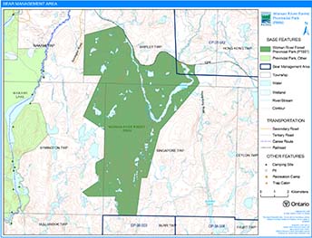
Enlarge Figure 3: Bear Management Areas
Figure 4: Trapline Areas
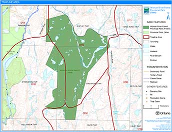
Enlarge Figure 4: Trapline Areas
5.1.3 Industrial resources
There are no licensed aggregate pits (active or inactive) located within the boundary of Woman River Forest Provincial Park. Aggregate extraction is not permitted in provincial parks (OMNR 1992; 2004a).
There are no existing mining claims within the park. All Crown land within the park has been withdrawn from mining activity under the Mining Act (1990) . Mineral exploration or extraction is not permitted (OMNR 1992; 2004a).
5.1.4 Access and crossings
Access
The park has limited road access. Logging access roads, which run to the west and east of the park, allow for access to the northern portions of the park.
The northern area of the park is also accessible by using the Canadian Pacific Railway (CPR), which travels along the northern boundary for the park.
Roads
Symington Road, a forest access road, comes within 100 metres of the northwestern part of the park boundary. Another forest access road, the Hong Kong Road, travels along the park’s eastern boundary.
Where existing forest access roads are essential for continued access beyond the park for forest management or recreation purposes, and alternative road access does not exist, or road relocation is not feasible, existing roads will continue to be available for access. Continued use will include maintenance and may include upgrade (OMNR 2004a). Ontario Parks is not responsible for the maintenance or upgrade of any roads within the park boundary.
Any proposed development, maintenance or upgrading of existing roads must meet all Environmental Assessment Act requirements.
Railway
The CPR corridor travels along the northern boundary of Woman River Provincial Park. The corridor of the railway is not included within the boundary of this park.
Utility corridors
All public utilities (e.g. gas pipelines, transmission lines, communications towers) must avoid park lands wherever possible. New utility corridor crossings may be necessary to maintain essential public services (OMNR 2004a).
Any future utility corridors proposed through the park, where park lands are unavoidable, will be reviewed on a case-by-case basis. Protection of park features and values will be priority and all requirements of the Environmental Assessment Act will be met.
5.1.5 Adjacent land management
Forestry
The lands adjacent to this park are located in the Spanish Forest management unit and the Superior Forest management unit.
The Spanish Forest is currently managed by Domtar Incorporated.
The Superior Forest is currently managed by Tembec Industries Incorporated.
Provincial parks
Wakami Lake Provincial Park is located west of Woman River Forest Provincial Park. Wakami Lake Provincial Park was regulated as a provincial park in 1973. An addition to the park was identified through Ontario’s Living Legacy. The eastern boundary of the addition to Wakami Lake is approximately three kilometres from the western boundary of Woman River Forest Provincial Park.
5.1.6 Land disposition
New land disposition for the private use of individuals or corporations will not be permitted (OMNR 1992; 2000)
Land use permits, licenses of occupation, unauthorized occupations
There is one private recreation camp land use permit (LUP) within the park located along the CPR line and the Woman River. This LUP is permitted to continue (OMNR 1999). There will be no new dispositions for private recreation camps (OMNR 1999, OMNR 2004).
Existing authorized LUPs for recreation camps may be eligible for enhanced tenure but not the purchase of land. Recreational camp LUPs cannot be changed to commercial land use permits unless this is supported during a review as part of park management planning. Enhanced tenure, is defined as a possible extension of the term of the land use permit for recreation camps up to 10 years or upgrade in tenure (i.e. land use permit to lease) (OMNR 2000a).
Enhanced tenure for an LUP for a recreation camp is not guaranteed. Requests for enhanced tenure, or to transfer recreation camps, will be reviewed based upon the following criteria:
- Continued compliance with the conditions of the land use permit for recreation camps
- Current land disposition policies for land use permits
- Consistency with park objectives to sustain values – no effects on heritage values and/or conflict with other uses
- Consistency with Aboriginal land claim negotiations or protocol agreements
- All rents, taxes, fees, rates or charges are paid and in good standing
An extension in the term of tenure for an existing private recreation camp LUP does not convey a commitment to provide for a change in the type or the standard of existing access to the private recreation camp.
There are no unauthorized occupations or licenses of occupation within the park.
Patent land
There are no patent lands within Woman River Forest Provincial Park.
5.1.7 Boat caches
There are no authorized boat caches within this provincial park. Boats are not permitted to be left unattended in the park without written permission from the superintendent under the authority of the Provincial Parks Act.
5.2 Aquatic ecosystems
Woman River Forest contains headwater sources for at least three rivers, creeks and tributaries (Woman River, Little Wakami River, and Buckshot Creek) (Crins 1996).
Sustaining high quality water resources is fundamental to the protection of park and adjacent land values. The MOE enforces applicable legislation and regulations pertaining to water quality.
5.2.1 Water management
There are no dams, water control structures, or diversions within the park boundaries, nor will any be permitted in the future (OMNR 1992).
5.2.2 Fisheries management
Fisheries management will complement maintenance and enhancement of the native, self-sustaining fish populations. Non-native fish species will not deliberately be introduced into the waters contained in the park (OMNR 1992).
The Chapleau District Fisheries Management Plan provides direction for fisheries management in this area.
Sport fishing
Sport fishing is permitted within Woman River Forest Provincial Park. Any sport fishing activity is governed by the legislation and regulations in the Fish and Wildlife Conservation Act, as well as the Fisheries Act (1985). The Fishing Regulations Summary contains more details regarding general regulations and exceptions to these regulations for the area of this park.
Commercial fishing
There are no commercial fishing operations within Woman River Forest Provincial Park. No new operations will be permitted (OMNR 1992).
Commercial baitfish harvesting
Baitfish licenses CH0152 and CH0167 (Shipley and Singapore townships) are currently allocated for use. License CH0166 (Symington Township) is not currently allocated for use.
Existing commercial baitfish harvesting may continue where the activity has been licensed or permitted since January 1, 1992. This activity may be subject to conditions identified through future park management planning or fisheries management plans. New baitfish licenses will not be permitted (OMNR 2000; 2003).
Fish stocking
The stocking of native fish species may be considered through park management planning, with full public consultation (OMNR 2004). Non-native fish species will not be deliberately introduced into park waters (OMNR 1992).
6.0 Operations policies
6.1 Recreation management
Future planning, with full public consultation, will review direction on motorized and non-motorized recreation uses.
6.1.1 Motorized recreation
Motorboats
The existing use of motorboats is permitted to continue, unless park values are being threatened. The long-term management direction for private and commercial boat use will be determined through park management planning, which includes public consultation (OMNR 2004).
Snowmobiles
There are currently no authorized snowmobile trails within the park boundary. Proposals for new trails may only be considered through future planning with public consultation (OMNR 2000).
The off-trail use of snowmobiles is prohibited unless authorized by the park superintendent under the authority of the Provincial Parks Act and is consistent with park policy.
All-terrain vehicles
There are currently no authorized all-terrain vehicle (ATV) trails in the park. Proposals fornew trails may only be considered through future planning with public consultation (OMNR 2000).
The off-road use of all-terrain vehicles is prohibited unless authorized by the superintendent under the authority the Provincial Parks Act and is consistent with park policy.
Aircraft
Aircraft landings are permitted within the park (OMNR 2004). All aircraft landings are subject to regulation and valid aircraft landing permits issued by the park superintendent under the authority of the Provincial Parks Act (1990).
6.1.2 Non-motorized recreation
Camping
There are no existing camping facilities within the boundary of Woman River Forest Provincial Park. Any existing, unmanaged use is permitted to continue unless park values are being threatened (OMNR 2004a).
Ontario Parks may assess the condition of existing campsites and will maintain, rehabilitate or close sites as required. If there is an identified need, new backcountry campsites may be considered (OMNR 2004a). Infrastructure will be permitted in order to protect park features and values in response to use, environmental deterioration and environmental protection requirements. Any proposed development in the park must fulfill the requirements of the Environmental Assessment Act.
Figure 5: Commercial Baitfish Harvesting
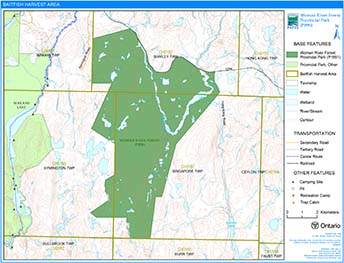
Enlarge Figure 5: Commercial Baitfish Harvesting
Hiking
There are no existing hiking trails in the park. Long-term management direction will be determined through park management planning, with full public consultation (OMNR 2004).
If there is an identified need, the development of new hiking trails may be considered. Trail infrastructure to protect park values and features will be permitted. Any proposed development within the park is subject to Environmental Assessment Act requirements.
Canoeing/kayaking
There is no known canoe route use within the park. Any existing use may continue, unless park values are threatened (OMNR 2004). Infrastructure to protect park features and values may be permitted and developed in response to use, environmental deterioration and environmental protection requirements.
6.1.3 Emerging recreation uses
There are emerging recreation uses for which there is no or limited policy to deal with their management (e.g. adventure racing, geocaching). The park superintendents will use legislation, policy and guidelines that are in place in the interim to manage emerging uses.
6.2 Development
No park infrastructure exists within the park.
Infrastructure to protect park features and values may be permitted and developed in response to use, environmental deterioration and environmental protection requirements. Any proposed development within the park is subject to the Environmental Assessment Act.
6.3 Commercial tourism
No commercial tourism infrastructure exists within the park. New commercial tourism facilities may be considered where consistent with park policy (OMNR 2004). Any development must meet the requirements of the Environmental Assessment Act.
7.0 Cultural resources
The management of any cultural resources will be directed toward identification, protection, and heritage appreciation (OMNR 1992). Cultural resource surveys of the park have not been completed to date.
8.0 Heritage education
Literature and other supporting information may be developed to describe the park in the context of Ontario’s provincial park system. Boundary limits, significant heritage features and permitted uses of the waterway park may be included in park literature.
Prospective park visitors may be informed about the sensitivity and significance of park values through park literature.
9.0 Research
Scientific research by qualified individuals which contributes to the knowledge of natural or cultural history, or to environmental or recreational management, may be encouraged in the park. Ontario Parks will encourage institutions, such as universities, to undertake research projects.
All research programs will require the approval of Ontario Parks and are subject to park policy and other applicable legislation. Any materials removed from the park will remain the property of Ontario Parks.
Approved research activities and facilities will be compatible with the park’s protection objective. Any site which is affected by research will be rehabilitated as closely as possible to its original state. Environmental Assessment Act requirements will apply.
10.0 References
Crins, W.J., 1996. Area of Natural and Scientific Interest Life Science Checksheet: Woman River Forest and Lowlands.
Fish and Wildlife Conservation Act, 1999.
Fisheries Act, 1985.
Frey, E. and D. Duba, 2002. Earth Science Checksheet: Woman River Forest Provincial Park. Ontario Ministry of Natural Resources.
Harper, T., 2003. Woman River Forest Provincial Park (P1551) Recreation Inventory Report – Version 1.3.
Migratory Birds Convention Act, 1994.
Mining Act, 1990.
Morris, E. R., 2002. Natural Heritage Area Life Science Checksheet: Woman River Forest Provincial Park (P1551).
Ontario Ministry of Natural Resources, 1974. A Topical Organization of Ontario History. Historic Sites Branch Division of Parks.
Ontario Ministry of Natural Resources, 1989. Chapleau District Fisheries Management Plan 1989-2000.
Ontario Ministry of Natural Resources, 1992. Ontario Provincial Parks Planning and Management Policies.
Ontario Ministry of Natural Resources, 1999. Ontario’s Living Legacy Land Use Strategy.
Ontario Ministry of Natural Resources, 2000. Ontario’s Living Legacy Land Use Strategy (Policy Clarification).
Ontario Ministry of Natural Resources, 2003. Directions for Commercial Resource Use Activities in Provincial Parks and Conservation Reserves. 5 pp.
Ontario Ministry of Natural Resources, 2004a. Crown Land Use Policy Atlas.
Ontario Ministry of Natural Resources, 2004b. Forest Fire Management Strategy for Ontario. Aviation and Fire Management Branch.
Ontario Ministry of Natural Resources, 2005. A Class Environmental Assessment for Provincial Parks and Conservation Reserves.
Pesticides Act, 1990.
Provincial Parks Act, 1990.
Appendix A: Background information
| Name | Woman River Forest Provincial Park (P1551) |
|---|---|
| Classification | Natural Environment Foleyet, Mississagi |
| Ecoregion/Ecodistrict | 3E-5, 4E-3 (Foleyet, Mississagi) |
| OMNR Administrative Region/District | Northeast - Chapleau |
| Total area (ha) | 6,322 |
| Regulation date & number | June 7th, 2003 (O. Reg. 210/03) |
Representation
Earth science:
Woman River Forest Provincial Park lies within the 2.75 to 2.67 billion year old western Abitibi Subprovince, in the Superior Province of the Precambrian Shield. Bedrock exposure in the park is generally poor, limited to minor lakeshore outcrops and valley train boulders. The Woman River area is almost entirely underlain by Archean granitic gneisses and migmatite batholithic rocks of the Ramsey Gneiss Domain, part of the Ramsey – Algoma granitoid complex, a widespread region of plutonic and gneissic rocks that was emplaced between ~2.70 and 2.68 billion years ago.
The surficial deposits are thin sandy ground moraine till, glaciolacustrine fine sand and glaciofluvial ice contact coarse sand and gravel. The till remains on the upland surfaces and in hillside pockets.
Life science:
Woman River Forest Provincial Park is deemed provincially significant for its diverse forest and wetland representations, as well as its old growth pine on an esker complex. The wetlands found in the area are mainly shore fens, meadow marshes and open-water marshes (Morris 2002).
The forest types represented are characteristic of the Boreal Forest and the Great Lakes St. Lawrence Forest regions. The species represented in the area include old-growth white pine, medium aged yellow birch, trembling aspen, white birch, red maple, jack pine, white spruce, black spruce, and tamarack (Crins 1996).
Cultural resources:
There has been no examination of the cultural values that may exist within Woman River Forest Provincial Park.
Recreation & tourism:
Limited access to this park hinders its recreational use. Recreation in the park is currently limited to remote backcountry activities. Development of access and a small trail system within this park could allow for potential recreational activities such as hiking, camping, nature appreciation and interpretation to be possible.
There is currently one private recreation camp land use permit located within this park boundary. There are no commercial tourism facilities located within park boundaries.
Woman Lake, which is included in the park, is classified as a tourism lake in the Chapleau District Land Use Guidelines.
Inventories
| Survey Level | Earth Science | Life Science | Cultural | Recreational |
|---|---|---|---|---|
| Reconnaissance | Frey and Duba, 2002 | Morris, 2002 | Harper, 2003 |