Fill Quality Guide and Good Management Practices for Shore Infilling in Ontario
The management goal of the Ontario Fill Quality Guide and the Good Management Practices for Shore-infilling in Ontario is to protect aquatic ecosystems by protecting the quality of the sediment and water in areas adjacent to shore-infilling activities.
Revised in 2011 by M. Gordon and T. Fletcher Standards Development Branch Ontario Ministry of the Environment
This publication may be reproduced for non-commercial purposes with appropriate attribution.
Executive summary
The management goal
Definition:
- Shore infilling
- Shore infilling is the practice of creating new land by placing rubble, stones, concrete, brick and loose earth into shallow areas in lakes and rivers. Shore filling may be undertaken to protect shores from erosion or floods and to create land for parks, marinas and wildlife preserves.
The management goal of the Ontario Fill Quality Guide (Guide) and the Good Management Practices for Shore-infilling in Ontario (Good Management Practices) is to protect aquatic ecosystems by protecting the quality of the sediment and water in areas adjacent to shore-infilling activities.
The need for such a goal was demonstrated because monitoring of some existing shore filling sites suggested that in some cases the quality of fill used degraded the quality of the water and sediment, and had deleterious effects on aquatic organisms.
Fill Quality Guide
Contaminated fill should not be placed in water along a shore or bank or adjacent to water along a shore or bank. Materials placed behind impermeable barriers on the shore or bank that can withstand a one-in-one hundred year storm are not subject to the Fill Quality Guide.
Fill Quality Good Management Practices
Good management practices explain how contaminated and uncontaminated fill can be identified, and also suggest how each can be managed.
A brief history of Fill Quality Good Management Practices
From 1976 to 1992, the quality of fill to be placed directly into the water was evaluated against criteria outlined in the Ontario Ministry of the Environment 1976 Open Water Disposal Guidelines for dredged sediment (originally Section 12 in: Persaud and Wilkins, 1976, and thereafter in several subsequent manuscript updates e.g. Appendices A – C in Environment Canada and the Ontario Ministry of the Environment, 1982). These guidelines were developed to determine whether dredged material was suitable for disposal in open water, and they were also used to evaluate potential fill of terrestrial origin. In 1992 the first version of this text, then entitled Fill Quality Guidelines for Lakefilling in Ontario - Application of Sediment and Water Quality Guidelines to Lakefilling, replaced the use of the Open Water Disposal Guidelines.
The accompanying Good Management Practices describe the quality of the fill which may be used in shore infill projects. This Guide and the related Good Management Practices, together with the Provincial Sediment Quality Guidelines (in Appendices - see Fletcher et al., 2008 for explanation) will provide enhanced protection of the aquatic environment. See Appendix A for detailed information.
Shore-infilling is regulated by provincial, federal, municipal and other agencies
Use of this Fill Quality Guide and the Good Management Practices is voluntary. The Ontario Ministry of the Environment has no approval role in shoreline management – the intent of this guide is to suggest to other agencies and proponents ways of assessing the suitability of the quality of fill so that the management goal of protecting aquatic ecosystems is attainable.
Shore-infilling activities can be subject to requirements of provincial, federal, and municipal legislation and regulations, and related policies – and to legal requirements of agencies such as Conservation Authorities. Proponents of shore infilling and regulatory agencies may choose to use this Guide and Good Management Practices as an aid when deciding what attributes best describe clean fill. A partial listing of some pertinent Provincial, Federal legislation and regulations and municipal by-laws can be found in Appendix B.
Summary of Good Management Practices
Definition:
- Fill types
- Material which may be used for shore infilling projects, is divided into two categories – contaminated or uncontaminated. To achieve the environmental management goal, contaminated fill must be confined whereas uncontaminated fill does not require confinement. Throughout this document, reflecting Good Management Practices, uncontaminated material is called unconfined fill and contaminated fill is called confined fill.
Confined fill may be used when placed within the confines of a structure, such as a dyke, which is capable of withstanding the waves of a one-in-one hundred years storm. The intent of confinement is to prevent the fill from coming into contact with the open water and, in the event of a storm or high waves, being washed away. Placing contaminated fill on a one-in-one hundred year floodplain of a stream or river system is also not considered to be a good practice, despite confinement, due in part to threats to the confinement structure arising from flood currents, and/or the effects of ice scour and catastrophic effects of ice dam failure or removal, and to the consequent potential for significant downstream dispersion of contaminants should failure of a confinement structure occur, and to the greater potential for significant unwanted aquatic effects and effects on downstream users. Placing uncontaminated fill into flowing water such as streams and rivers requires technical knowledge of fluvial geomorphology and aquatic habitat (e.g. see Ministry of Natural Resources, 2002) and is an activity regulated by a number of agencies.
Unconfined fill may be placed directly into open water.
A series of stringent tests is used to determine whether fill can be considered contaminated or not. These include:
- bulk chemical tests for 8 metals and organic compounds including polychlorinated biphenyls (PCBs), arsenic, cadmium, chromium, copper, lead, mercury, nickel, zinc, total organic carbon and total phosphorus.
- a Receiving Water Simulation Test which determines whether or not organic compounds, such as PCBs, leach from the fill.
- further tests which may be requested by a regulatory agency on a case by case basis. The tests may include additional chemical analyses for nutrients, other metals, and organic compounds listed in the Provincial Sediment Quality Guidelines (see Fletcher et. al., 2008(a)).
Definition:
- Background concentration
- This chemically describes the quality of the sediment before it was affected by human activity.
- Lowest Effect Level
- This is the level of contamination in the sediment at which testing shows there is no toxic effect on the majority of sediment- dwelling organisms.
Uncontaminated fill which can be used in an unconfined manner also satisfies the Lowest Effect Level of the Provincial Sediment Quality Guidelines for organic parameters and either the Lowest Effect Level or the background level of the sediment for metals and for organics (Tables 3 and 4 in Fletcher et. al., 2008(a)). Unconfined fill is also free of substances which could bioaccumulate in organisms and of substances which could form objectionable deposits - such as scum - or degrade the potential of the water for recreation or as a habitat for aquatic life.
Under the Good Management Practices, fill which fails the tests for Unconfined Fill may qualify as Confined Fill if it meets the requirements for Confined Fill. Material that fails the requirements for Confined Fill should not be used for shore infilling and should be managed in accordance with other policies (e.g. municipal policies such as MacMillan and Crowther, 2005) and applicable procedures developed to address the movement or disposal of excess soil such as Regulation 347 General - Waste Management.
While the shore infilling project is being built, all reasonable measures should be taken to minimize turbidity and to reduce the loss of fill. Precautions may include placing fill only during calm/low flow periods and/or protecting all exposed areas of the shore infill project from severe storms by dykes and enclosures to prevent erosion.
Foreword
This Guide and Good Management Practices are intended to aid users in evaluating the suitability of fill material for shore-infilling. The Good Management Practices are designed to help protect the aquatic environment from the physical effects of infill, and from contaminants associated with shore infill materials
Although this Guide and Good Management Practices may assist proponents and regulators in determining whether or not a proposal may result in unwanted environmental effects, use of this Guide and Good Management Practices does not exempt proponents of proposed projects from current evaluation procedures or approval requirements under legislation administered by the Ministry of the Environment, or by other Ministries or agencies. Proponents are responsible for complying with all pertinent laws and conforming with pertinent policies; federal, provincial, and/or municipal.
The Good Management Practices incorporate features of the Provincial Sediment Quality Guidelines (Fletcher et al., 2008(a)) to ensure protection of sediment and the Provincial Water Quality Objectives (Ontario Ministry of the Environment and Energy, 1994) to ensure protection of water quality and water uses. Some provisions in this document relating to the suitability of fill material for shore infilling, specifically the use of criteria in the Confined fill management practices, contain references to material in the Ministry publication Guidance on Sampling and Analytical Methods for Use at Contaminated Sites in Ontario (Ontario Ministry of the Environment and Energy, 1996). This latter reference also provides some general suggestions on sampling soil and sediment when assessing whether either are contaminated.
In addition to the protection of water and sediment quality, many other issues such as habitat alteration, alteration of current patterns, and siting and design, ought to be addressed before a shore infill is built.
Introduction (1.0)
Creation of new land through filling in the shallow nearshore littoral zone can be an appealing concept for several reasons. With waterfront property commanding a premium price, the creation of new land by shore infilling is attractive, particularly in the heavily populated western basin of Lake Ontario and in developing areas on smaller lakes and larger inland waterways and rivers such as highly valued recreational properties in “cottage country”. In many cases, shore infills provide commercial and recreational opportunities that would otherwise not exist and could not be provided through the purchase of existing shore properties. Concerns over the environmental implications of shore infilling that have been consistently raised over many years, and greatly increased during the early 1990s across western Lake Ontario, particularly in the Greater Toronto area.
The impact on the aquatic environment of building shore infills using the present methodology has not been adequately assessed. However, monitoring of existing sites has, in some cases, indicated degraded soil, water and sediment quality, and disruption of aquatic communities in the vicinity of shore infill structures. Concern has centered around the quality of the material that has been used in shore infills. Monitoring of fill quality has indicated that material with the potential to impair water and sediment quality has entered some shore infills.
Shore infilling in Ontario - Background (1.1)
Definition:
- Shore Infilling
- Shore infilling refers to the placement of solid material, such as rubble, broken concrete, stone, loose earth, and granular material in abutting surface water, such as in lakes and rivers, to:
- Create structures for flood and erosion control (such as shoreline protectior or stavlization works)
- Create land (such as, waterfront parks and recreational boating facilities, beaches, nourish shorelands)
- Confine disposal facilities for dredged material
- Enhance, rehabilitate, or create aquatic habitat
- beach nourishment.
Most of the large shore infilling conducted in Ontario to create land was centered in the western basin of Lake Ontario, especially the area adjacent to the Toronto waterfront. For instance, from 1911 to 1999, the former federally chartered Toronto Harbour Commission (succeeded in 1999 by the Toronto Port Authority) used infilling to develop the Toronto waterfront. Since the 1950's, the Commission was involved in the construction of the Eastern Toronto Harbour Headland (also known as the Leslie Street Spit) which is the largest shore infill structure in Lake Ontario. From 1911 to 1989, the Commission was responsible for shore infilling which created approximately 1,000 hectares (2,500 acres) of waterfront land (Royal Commission on the Future of the Toronto Waterfront, 1989).
During the late 1960s and 1970s, the Conservation Authorities bordering the Great Lakes and other municipal and provincial government agencies proposed Shore management plans which included coastal engineering works involving varying degrees of land creation through shore infilling. Since 2001, where they exist, Ontario Conservation Authorities were delegated responsibility for “on-the-ground” implementation of all aspects of the Ministry of Natural Resources Natural Hazards Policies (3.1) of the Provincial Policy Statement of the Ontario Planning Act (Lawrence (1995 (a, b, c), Lawrence (1998), McRae and Watt, 2006). These include policies for shoreline erosion hazards, and dynamic beach hazards (e.g. Grand River Conservation Authority, 2006)
Origin of this Guide and Good Management Practices and relationship with management of surplus fill
The Provincial Fill Quality Guide and Good Management Practices, available to those proposing to infill a shoreline, can be used to assess the relative quality of candidate fill and as a guide to managing fill of various quality. Provincial guidelines and good management practices have evolved considerably since their birth as unpublished draft working guidelines during the early 1970s. Since then, a number of related legacy guidance publications have been published and are still available and readily accessible on the world wide web. In addition, the science necessary to identify contaminated sediment and fill of terrestrial origin became intertwined with legal developments in the broader field of waste management. Understanding the evolving inter-relationships in these bodies of work can prevent confusion arising from the many legacy publications from this convergent history. An explanation of these inter-relationships is provided in Appendix A.
Fill Quality Guide (2.0)
Contaminated fill should not be placed in water along a shore or bank or adjacent to water along a shore or bank.
Materials placed behind impermeable barriers on the shore or bank that can withstand a one-in-one hundred years storm are not subject to the Fill Quality Guide.
The management goal of this Guide is to protect the quality of the sediment and water in areas adjacent to shore filling activities. Environmental protection will be achieved by preventing the loss of fill and associated contaminants during shore infilling and subsequent to infilling. It is intended that fill managed in conformance with this Guide and with the associated Good Management Practices will not significantly impair water quality, aquatic life and habitat, and adjacent aquatic uses through the loss of fill. Good Management Practices
It is intended that use of the related Good Management Practices and criteria will address aquatic environmental concerns sufficiently so that the quality of fill and method of placement will also achieve additional management goals including:
- the 1994 Ontario Ministry of the Environment and Energy water quality management goal; "To ensure that the surface waters of the province are of a quality which is satisfactory for aquatic life and recreation", and
- the 1993 Ministry of the Environment (Persaud, D., R. Jaagumagi, and A. Hayton) goal for the protection and management of aquatic sediment quality in Ontario; ”…to protect the aquatic environment by setting safe levels for metals, nutrients (substances which promote the growth of algae) and organic compounds”
Use of this Guide and Good Management Practices (3.0)
This Guide and Good Management Practices are intended for use in the zone extending from the one-in-one hundred year wave uprush high water mark toward, and into, water. They are not intended for use with materials placed landwards from the one-in-one hundred year wave uprush high water mark. Placing contaminated fill on a one-in-one hundred year floodplain of a stream or river system is also not considered to be a good practice, despite confinement, due in part to threats to the confinement structure arising from flood currents, and/or the effects of ice scour and catastrophic effects of ice dam failure or removal, and to the consequent potential for significant downstream dispersion of contaminants should failure of a confinement structure occur, and to the greater potential for significant unwanted aquatic effects and effects on downstream users.
These Good Management Practices do not deal with planning issues such as cumulative effects assessment on aquatic systems resulting from many shore infilling activities. The cumulative aquatic effect of many constructed headlands or erosion control measures can be very significant. The aquatic management objectives within a pertinent large scale environmental plan [such as a Great Lakes Lakewide Management Plan aka “LaMP” (U.S. Environmental Protection Agency, 2008), or a Conservation Authority Watershed Management Plan)] can be used when establishing the context needed to assess the significance of related aquatic effects of one or more (i.e. cumulative effects) shore infilling projects. Local agencies such as Conservation Authorities should be consulted by a proponent wanting to conduct cumulative effects assessments on an aquatic system.
These Good Management Practices also do not provide detail describing the overall design of a shore infill. Some guidance describing the design and monitoring of confined shore infill can be found elsewhere such as in Hubertz et. al. (1991), Ontario Ministry of the Environment and Energy (2010(b-e)), Ontario Ministry of the Environment and Energy (1995(b-f) and in Herbich (2000).
A proponent of a proposed shoreline infilling project ought to also determine which of the many Federal and Provincial Acts, regulations, municipal by-laws, and policies may apply to the proposed project. A partial listing of the legislation in Ontario which may affect the siting, design and construction of a shore infill can be found in Appendix B.
Types of projects where this Guide and Good Management Practices are useful (3.1)
The Fill Quality Guide and Good Management Practices could be used by a proponent for shore infill projects such as:
- shore stabilization
- construction of piers, groynes, docks, and causeways;
- construction of breakwaters and Confined Disposal Facility perimeter walls/structures;
- large-scale projects for recreational purposes (e.g., Bluffers Park); and
- beach nourishment, enhancement or creation.
It is not intended that the Fill Quality Guide and Good Management Practices be used for the following undertakings:
- contaminated material placed within a Confined Disposal Facility structure such as dredge spoils. This activity requires regulatory approval under Part V of the Environmental Protection Act and conditions of disposal will be regulated through Certificates of Approval since these structures are designed to contain specific materials for disposal;
- material placed on shorelands inshore from the one-in-one hundred year high water mark. (Such materials should be adequately stabilized or protected to prevent erosion of material into the watercourse);
- in-filling behind impermeable barriers such as concrete or sheet pile revetment walls (subject to appropriate treatment of decant water); and
- projects designated as emergency shore works (designated by a MOE Regional Director), such as repairs and maintenance to flood and beach protection works.
Good Management Practices for Fill Placement (4.0)
General conditions (4.1)
Timing: Shore filling of standing water should only take place during the defined calm period in those areas subject to storm/wave/flooding damage (e.g. typically June to August on the Ontario Great Lakes or determined using the hindcast method). Shore filling of running water should only take place during periods of low flow. Some hindcasting and forecasting guidance is provided by National Oceanic and Atmospheric Administration (2009), Baird and Associates (2003), Khandekar and Swail (1995), Hubertz et. al. (1991), and by the Ontario Ministry of Natural Resources (1988 (a, b, & c), 1989, and 2001). According to McRae and Watt, (2006), the coastal floodplain is generally accepted to be the sum of the 1:100 year water level, and an allowance for wave uprush and storm surges (Danard et al., 2003). The Ontario Ministry of Natural Resources has defined 1:100 year water levels on each part of the Great Lakes system (Ontario Ministry of Natural Resources, 1989). These boundaries are based on statistical analysis of historical levels, as well as an allowance for wind setup. Wave uprush is caused by waves breaking onto a shoreline and water spreading inland into areas that are not normally inundated. During a major storm, powerful waves may damage shore protection works, flood buildings, and quickly erode soil and pavement. Water levels and stream discharge may be affected by climate change, which may alter the volume of water (and therefore the water level) in a basin, as well as the frequency and/or severity of major storms (either more or less). For this reason, the defined 1:100 year high water levels may be adjusted in the future, as knowledge about the effects of climate change evolves. For greater certainty about flood boundaries, a proponent ought to contact the regulatory agencies (e.g. MNR, local Conservation Authority, Municipal office,…etc.) to obtain further information and confirm the definition of the 1:100 year high water mark for the area of interest.
Working Face: To reduce erosional losses, the exposed face of an infill ought to be constrained to as short a length as possible – such as 15 metres.
- Protection Against Erosion of Fill: In instances where Confined Fill will be used in a shore infill, an outer structure ought to be constructed of material satisfying the Unconfined Fill criteria (e.g., quarried stone, concrete rubble, or other similarly inert material). The outer structure must be completed to provide full protection before commencing placement of material classified as Confined Fill. Confined fill ought to be placed within a confining structure such that there will be no loss of material to the surrounding aquatic environment. Additional suggestions about some aspects of construction can be found in Ontario Ministry of the Environment and Energy, 1994(d), (e), 1995(a), (b), (c), (d), (e) (f), and in Miller, 1998 and 2003.
Siting and some design considerations (4.2)
To ensure a shore infill will not affect water uses, shore infills ought to be located to:
- not affect water intakes or outfalls;
- not affect navigation routes or shipping channels;
- ensure that eroded material will not affect the structural or functional integrity of onshore and offshore discharges or intakes or other sensitive water uses, and
Shore infills should be designed to:
- minimize the amount of semi-protected shore created;
- not create embayment areas;
- ensure that sediments are not deposited by ensuring that embayments are well flushed;
- prevent direct input of storm sewers or other discharges into embayments;
- ensure that the confinement structure is built before material classified as Confined Fill is deposited;
- ensure that the confining structure will withstand the most significant wave that could occur in storms over a 25-year period during the active filling phase;
- protect the confining structure at the end of the filling season or upon completion of the project, to withstand the estimated 100-year storm significant wave prior to the end of the calm period
footnote 3 or low flow period during which confined fill was first deposited.
Good Management Practices environmental criteria (5.0)
General (5.1)
The Good Management Practice environmental criteria
During construction of an infill, major aquatic effects are often associated with loss of fill material along with the contaminants associated with the fill. These aquatic effects may be chemical and/or physical. Unwanted changes to receiving water and sediment chemistry can occur, as can unwanted changes from suspended and deposited sediment. For instance, suspended sediment can reduce light penetration, and also result in stress and have toxic effects,while deposited sediment can reduce streambed substrate composition, permeability, and stability, and bury bottom organism to varying degrees. Such chemical and physical effects can result in impairments and in adverse effects on aquatic life and on aquatic habitat. Considerable description of aquatic effects of sediment on aquatic systems can be found in aquatic literature (for instance, see Canadian Council of Ministers of the Environment, 2002; Kerr, 1995; Ontario Ministry of the Environment, 1979).
The screening system outlined in Figures D-1 to D-3 in Appendix D is used to identify two categories of fill; Confined fill and Unconfined fill.
Definition:
- Confined fill
- This material satisfies only the initial screening criteria and ought to be used only within a confined shore infill.
- Unconfined fill
- This material satisfies the initial screening criteria as well as more restrictive criteria. More restrictive criteria are used because unconfined fill can be placed in direct contact with open water, including use in constructing a fill confining structure. A proponent can choose to determine whether candidate material which satisfies the criteria for Confined fill also satisfies criteria for use as Unconfined fill.
Fill Quality evaluation (5.2)
Suitability of materials for use as unconfined deposit, or for deposit in a confined shore infill structure, is assessed in part based on knowledge of fill history, and in part based on chemical evaluation
Material which satisfies the Unconfined Fill criteria, as well as the Receiving water simulation test is classified as Unconfined Fill and can be placed in contact with open water. Analysis ought to include all parameters identified in Table C-2 (Parameter List for Unconfined Fill). Analysis of additional parameters may be required by a regulatory agency on a case-by-case basis dependant on the history of the fill donor site.
Quarried rock, clean brick, concrete rubble, sand, gravel and excavated soils could be used for shore infilling when the quality of that material satisfies criteria described in this section. This material ought not to contain other construction debris or putrescible material, and it ought to be free of visible staining, and be free of odour. Typically there is no need to chemically assess these materials except where there may be a concern regarding the origin of the material. For instance, brick or concrete rubble coming from an installation where it may have been contaminated, such as an industrial site, ought to be tested for those parameters that a review of the site history has indicated may be of concern. Where there is visible staining by oils or other substances, the material ought not to be used for shore infilling. In the case of quarried rock, some areas of the province have naturally higher levels of some metals. Where locally high occurrences of some metals may be of concern, the rock ought to be subjected to a Receiving Water Simulation test to assess whether these metals can rapidly leach into water.
Asphalt and construction debris, chimney brick or painted brick, slag, fly ash and other industrial/ commercial wastes and/or by-products ought not to be used in an unconfined shore infill because it is likely that these materials could introduce contaminants into aquatic systems. To achieve the environmental management goals, a proponent wishing to use such materials as fill ought to scientifically determine that such candidate material will not adversely affect the aquatic environment.
Candidate fill material which satisfies the Confined fill criteria listed in Tables C-1: Confined Fill Guide Parameter List and C-2: Unconfined Fill Guide Parameter List of Appendix C, could be placed into a confined shore infill. If the material is destined to be placed into a Confined Fill area, no additional testing is needed.
Confined fill material criteria (5.2.1)
The Confined fill criteria found in Tables C-1 are primarily based on the protection of the terrestrial environment. These are intended to be used as a screening aid when deciding whether candidate fill material ought to be confined or not.
Materials of commercial or industrial origin are more likely to contain greater numbers and concentrations of unwanted contaminants than is material of residential or parkland origin. Regardless of origin, all material ought to be tested for the parameters listed in Table C-1. Where a site has historically been used for purposes other than agricultural or residential, analysis for additional parameters listed in Table C-2 ought to be conducted. The number of parameters listed in Table C-2 may be reduced if there is no history of use at the fill donor site of the parameters to be excluded, and the candidate fill materials are not likely to have been contaminated by airborne pollutants (e.g. lead).
Candidate fill materials is not suitable for confined, or unconfined fill if the concentration of a parameter in a single sample, or the arithmetic mean of the concentration of a parameter within replicate samples, is numerically greater than the criterion for that particular chemical parameter listed in Table C-1: Confined Fill Guide in Appendix C.
As already mentioned, the publication Guidance on Sampling and Analytical Methods for Use at Contaminated Sites in Ontario (Ontario Ministry of the Environment and Energy, 1996) provides some suggestions on sampling soil and sediment when assessing whether either are contaminated. The actual sampling design used for assessing and mapping soil contamination at a particular site should be determined, conducted and supervised by persons with qualifications similar to those identified for “qualified persons” in Ontario Regulation 153/04
Unconfined fill material criteria (5.2.2)
D-3 in Appendix D. Candidate material will be tested by bulk chemical analysis and results reported on a dry weight basis (Ontario Ministry of the Environment, 2004 [amended as of July 1, 2011]).
Site-specific suitability of fill
Organic compounds
The quality of proposed fill material ought not exceed the No effect level (Figure D-2) when ambient sediment quality in the vicinity of the shore infill is equal to or better than the No effect level of the Provincial Sediment Quality Guidelines (Fletcher et al. (2008)).
If ambient sediment quality exceeds the No effect level but satisfies the Lowest effect level of Table C-2: Unconfined Fill Guide, then the fill material quality ought not exceed the Lowest effect level. If concentrations of parameters in the fill material quality exceed the Lowest effect level, the material ought not be used as Unconfined fill.
Other parameters
If ambient sediment quality in the vicinity of the shore infill is equal to or better than the Lowest effect level, then the fill material quality ought not to exceed the lowest effect level (Figure D-3).
If ambient sediment quality exceeds the Lowest effect level, then the quality of candidate fill material ought to be equal to or better than ambient, provided that the quality of the fill material does not exceed background concentrations. Background levels are determined according to the procedure provided in the Guidelines for identifying, assessing and managing contaminated sediment in Ontario: An integrated approach (Fletcher et al., 2008(a) & (b)).
As well as satisfying the Site-specific suitability criteria, material being assessed for use as Unconfined fill ought to also:
- be free of substances that could form objectionable deposits. Visual screening of the material should be used to ensure it is free of substances such as vegetation, wood, paper, plastic products, metal scraps, odoriferous and colour-imparting materials;
- be free of substances that are acutely lethal to aquatic life (OMOE 1992);
- not create water quality conditions that would impair the health and well-being of aquatic life and other normal water uses. This evaluation ought to include using the Receiving water simulation test procedure described below
footnote 7 ; and - be free of substances that could result in significant bioaccumulation in aquatic organisms.
The material can be classified as Unconfined fill when all of the above criteria have been satisfied.
Receiving water simulation test
The goal of this test is to simulate water column conditions at the fill face and predict water quality impairment and also assess whether dissolved concentrations of bioaccumulative substances may result during the deposit of fill.
The water column at the fill face is simulated by placing one part of fill material into twenty parts of distilled water on a weight-to-weight basis and mechanically agitating the mixture for 24 hours. After a settling period of one hour, aliquots of the supernatant are decanted, filtered through a 045 µm glass fibre filter. The filtered supernatant is then analyzed for the presence of bioaccumulative parameters listed in Table C- 2 mandatory list, such as PCBs and mercury, and other parameters listed in Table C-2 which exceed the No Effect Level guideline in a bulk chemical analysis. The concentration of these substances in the supernatant should be below the Provincial Water Quality Objectives/Interim Objectives (PWQO/IO).
The supernatant will also be analyzed for the other parameters in Table C- 1 that are known to be present in the material based on bulk chemical analysis. With the exception of mercury (CAS No. 7439-97-6), DDT and metabolites (CAS No. 50-29-3), Benzo(a)pyrene (CAS 50-32-8), Polychlorinated biphenyls, dioxins and furans, lead (CAS No. 7439-92-1) and other bioaccumulative contaminants, the concentrations of these substances should not exceed ten times the PWQOs/IOs - or other more stringent criteria [such as those by the Canadian Council of Ministers of the Environment (CCME)] based on more recent up-to-date published science. This assumes a 10:1 dilution in the near field of the dumping operation; if the dilution is less than 10:1, the appropriate factor applies. Due to its high bioaccumulative potential, concentrations of mercury in the supernatant should not exceed the PWQO or a concentration using an objective based on more recent up-to-date published science (e.g. such as may be derived by the CCME).
Rationale - Chemical effects (5.2.3)
When contaminants in fill materials are released to the aquatic environment they will either become dissolved in water or remain associated with particulate matter which may eventually settle to the bottom.
Contaminants in the water column, either in solution or associated with suspended particulate matter, can have a wide range of effects. For instance, exceedances of O. Reg. 169/03 Ontario Drinking Water Quality Standards could have potential effects on human health. Exceedances of the Provincial Water Quality Objectives (PWQOs) could have toxicological effects on aquatic biota, result in bioaccumulation of contaminants through the food web with possible toxicological effects on predators, and/or result in management restrictions on harvest of fishes, on human consumption of fishes or on fish habitat.
Most studies related to shore infilling in standing water have concluded that water quality effects are localized, with infrequent detection of nutrients, metals and organics above the PWQOs. Though neither acute nor chronic biological effects have been documented, detecting such effects in the field can be a difficult task.
A PWQO is designed to protect the most sensitive water use whether it be for the protection of aquatic biota, recreation, or other uses. In the vicinity of lake shore infills, the PWQOs are occasionally exceeded within a plume gradient, and usually in close proximity to the working face. Since acute biological effects in these areas have not been observed, it has been assumed that lake shore infilling has not had acute toxicological effects on pelagic biota (biota ranging throughout the water column). However, chronic effects may have occurred in localized lake areas near active infilling where PWQOs have been exceeded.
Fill lost to the aquatic environment from a shore infill site is eventually deposited on the bottom. In lakes, most will be deposited in the vicinity of the shore infill, at least on a temporary basis. Studies (Jaagumagi and Persaud 1992) have found elevated levels of some contaminants in biota and sediment in the vicinity of lake shore infilling operations on the Toronto waterfront.
There is little information describing the uptake of contaminants by biota in the vicinity of shore infilling during construction – in part because it is often difficult to separate the effects of shore infilling from that caused by other point and non-point sources of contaminants in large urbanized areas.
It can be reasonably assumed that, if the sediments lost during the filling process are contaminated, and there are no other significant sources of contaminants, then aquatic biota in areas adjacent to shore infilling will have higher contaminant body burdens than in areas not influenced by lost fill. Therefore, it is prudent to minimize the loss of fill, and to ensure that any fill lost is not contaminated.
Physical effects (5.3)
Turbidity criteria (5.3.1)
Excessive turbidity levels could interfere with achieving the environmental management goals. Where sensitive water uses are identified, turbidity levels ought to be kept within the specifications of the PWQO. Site monitoring is useful to ensure conformance with PWQOs. If concentrations of substances exceed the PWQO guidelines, a proponent’s immediate use of a project contingency plan (describing controls and/or mitigative measures) should ensure that the environmental management goals continue to be achieved. Examples of some contingency measures include installations of silt curtains or filling only behind dikes constructed of erosion-resistant material, or temporarily halting filling operations until the receiving water clears.
Rationale - Turbidity (5.3.2)
Increased turbidity
- “Water used for swimming, bathing and other recreational activities … should be devoid of … any substance which would produce objectionable … turbidity”;
and for “aquatic life” it states:
- “Suspended matter should not be added to surface water in concentrations that will change the natural Secchi Disc reading by more than 10 percent” (for technical rationale see Ministry of the Environment, 1979).
Biotic, physical and chemical conditions describing aquatic ecosystems are diverse, and water quality guidelines ought to be compared to natural background levels (CCME, 2002). The components of turbidity – especially suspended solids, can affect aquatic life in direct and indirect ways which can be short term and long term. Effects from turbidity arising from the activity of infilling and from eroding shore fill materials can also occur for some distance from the source – especially in flowing water where unwanted ecological effects and effects on water users can extend far downstream. Deposition of fine sediment can reduce streambed substrate composition, permeability, and stability and can produce long term unwanted effects. Turbidity can have adverse effects on biota – particularly the component concentrations of suspended solids. However, the short-term concentrations of suspended sediment in standing water required to adversely affect biota are generally greater than concentrations resulting from infilling within very nearshore areas. Localized levels of suspended solids above 25 mg/L above background (which is the generally accepted "no effect" level) may occur close to the active fill face, however such concentrations are not expected beyond the immediate vicinity of the fill face in standing water.
Studies indicate that increases in turbidity due to shore infilling activities are usually difficult to discern over natural background levels, although exceedances of the PWQO have been documented. These studies have been carried out in Lake Ontario in the Toronto area where background turbidity levels can be high, obscuring increases from shore infilling. In areas where background turbidity levels are low, exceedances of the PWQO would be expected close to active shore infilling if loose soil were being deposited directly into the water.
Sedimentation criteria (5.3.3)
Previously described mitigative measures will reduce turbidity and sediment losses in standing water. All sensitive water uses within the area where sedimentation is likely to occur ought to be protected, and affected users immediately advised of any accidental releases/spills.
To ensure that management goals are achieved, a proponent of shore infilling ought to identify appropriate control measures prior to undertaking the project as well as remedial measures and contingency plans that will be taken if impacts do occur.
Rationale – Sedimentation (5.3.4)
Fill lost during the shore infilling process is likely to be deposited either along adjacent shores or offshore, and could affect navigation routes, water intakes and discharges, and aquatic habitat.
Deposition of fine-grained sediments and associated changes in benthic (bottom-dwelling) biota community structure have been documented in the vicinity of shore infills as a direct result of the loss of fill.
References
Baird, W.F. and Associates Coastal Engineers Ltd.. 2003. Lake Ontario WAVAD hindcast for IJC study. 52 pp. plus seven Append. (Lake Ontario WAVAD Hindcast for IJC Study .)
Canadian Council of Ministers of the Environment (CCME). 2002. Canadian water quality guidelines for the protection of aquatic life: Total particulate matter. In: “Canadian environmental quality guidelines”. Canadian Council Ministry of the Environment. Pub. No. 1299. 13 pp.
Conservation Ontario. 2004. Regulation of development, interference with wetlands and alterations to shorelines and watercourses. Brochure. 4 pp. (O. Reg. 170/06.)
Danard, M., A. Munro and T. Murty. 2003. Storm surge hazard in Canada. Nat. Haz. 28(2-3). pp. 407-434.
Edwards, B.. 2010. Soil, groundwater and sediment quality criteria in Ontario: A History of their development from the 1970s to December 2009 - Technical report. Office of the Environmental Commissioner of Ontario. (Soil, groundwater and sediment quality criteria in Ontario.)
Environment Canada and the Ontario Ministry of the Environment. 1982. Lakefill quality study – Leslie Street spit – City of Toronto. 19 pp. plus 7 Append. ( Lakefill Quality Study Leslie Street Spit City of Toronto.)
Fletcher, R., P. Welsh, and T. Fletcher. 2008(a). Guidelines for identifying, assessing and managing contaminated sediment in Ontario: An integrated approach. Ontario Ministry of the Environment Standards Development Branch. 107 pp.
Fletcher, R., P. Welsh, and T. Fletcher. 2008(b). Appendix A: Protocol and rationale for setting provincial sediment quality guidelines. pp. 89 – 107 in: “Guidelines for identifying, assessing and managing contaminated sediment in Ontario: An integrated approach”. Ontario Ministry of the Environment Standards Development Branch. 107 pp.
Grand River Conservation Authority. 2006. Grand River Conservation Authority Lake Erie shoreline protection policy. 5. pp. (Lake Erie Shoreline Protection Policy.)
Hayton, A., D. Persaud and R. Jaagumagi. 1992. Fill quality guidelines for lakefilling in Ontario – Application of sediment and water quality guidelines to lakefilling. Guideline B1-4 Ontario Ministry of the Environment & Energy. 6 pp. plus Figs. and 3 Append. ( Application of Sediment and Water Quality Guidelines to Lakefilling.)
Herbich, J.B.. 2000. Handbook of coastal engineering. McGraw-Hill Professional.
Hubertz, J. M., D.B. Driver, and R.D. Reinhard. 1991. Wind waves on the Great Lakes: A 32 year hindcast. J. Coastal Res. 7(4). pp. 945-967 (See: Hindcast Wave Information For The Great Lakes: Lake Erie.)
International Joint Commission. 1988. Procedures for the assessment of contaminated sediment problems in the Great Lakes. Report to the Great Lakes Water Quality Board. Windsor, Ontario. 140 pp. (Procedures for the assessment of contaminated sediment problems in the Great Lakes.)
Jaagumagi, R., and D. Persaud. 1992. The in-place pollutants program Vol. VII: A synthesis of the program.(2 Pt set) Ontario Ministry of Environment and Energy. Toronto. (see: Part 1 and Part 2 )
Jaagumagi, R., and D. Persaud. 1996. An integrated approach to the evaluation and management of contaminated sediments. Ontario Minsitry of the Environment and Energy. 50 pp. [replaced by Fletcher et. al. 2008] ( An Integrated Approach to the Evaluation and Management of Contaminated Sediments.)
Khandekar, M. L., and Val R. Swail. 1995. Storm waves in Canadian waters: A major marine hazard. Atmospheric ocean. 33 (2), pp. 329-357. ( Storm waves in Canadian waters: A major marine hazard.)
Lawrence, P. L., 1995(a). Development of Great Lakes shoreline management plans by Ontario Conservation Authorities. Ocean and Coastal Manage. 26(3). pp. 205 – 223.
Lawrence, P. L.. 1995(b). Great Lakes shoreline management in Ontario. Great Lakes Geog.. 2(2). pp. 1-20 (Great Lakes Shoreline Management In Ontario.)
Lawrence, P. L.. 1995(c). Land-use planning reform in Ontario: Implications for Great Lakes shoreline management. Coastal Manage. 23: pp. 295-307.
Lawrence, P. L.. 1998. Ontario-Great Lakes shoreline management: An update. Coastal Manage. 6(2). pp. 93-104.
MacMillan, G., and W.G. Crowther. 2005. Task force on the opportunities for the establishment of long term dump sites for the disposal of excess clean native soils excavated from city projects. City of Toronto Technical Services. 8 pp. (See: Ontario‐great lakes shoreline management: An update)
McRae, R. and S. Watt. 2006. Great Lakes hazards planning: Experience from Southeastern Ontario. Great Lakes Geog.. 13(1). pp. 1-13. (Great Lakes Hazards Planning: Experience from Southeastern Ontario.)
National Oceanic and Atmospheric Administration 2009. Great Lakes Coastal Forecasting System, GLCFS website. Great Lakes Environment Research Lab.
Ontario Ministry of the Environment. 1983. Handbook of analytical methods for environmental samples. Volumes I and II. (15 MB)
Ontario Ministry of the Environment and Energy. 1992. Ontario’s water quality objective development process. Ontario Water Research Branch. 77 pp.
Ontario Ministry of the Environment and Energy. 1992/3. Guidelines for the protection and management of aquatic sediment quality in Ontario. Ontario Water Research Branch. 26 pp. (published in 1992 and reprinted in 1993).
Ontario Ministry of the Environment and Energy. 1994(a). Water management; policies, guidelines and provincial water quality objectives of the Ministry of the Environment and Energy. Toronto.
Ontario Ministry of the Environment and Energy. 2010(b). Evaluating construction activities impacting on water resources Part III A - Handbook for dredging and dredged material disposal in Ontario - Legislation, policies, sediment classification and disposal options.
Ontario Ministry of Environment and Energy. 2010(c). Evaluating construction activities impacting on water resources - part III B - Handbook for dredging and dredged material disposal in Ontario - Dredging transport and monitoring. Standards Development Branch.
Ontario Ministry of Environment and Energy. 2010(d). Confined disposal facilities (CDFs) pp. 22 – 29 Section 6.0 in: “Evaluating construction activities impacting on water resources part III A - Handbook for dredging and dredged material disposal in
Ontario - Legislation, policies, sediment classification and disposal options”. Standards Development Branch.
Ontario Ministry of Environment and Energy. 2010(e). [Monitoring of] Shoreline and upland confined disposal facilities (CDFs) pp. 22 – 24 in “Evaluating construction activities impacting on water resources - Part III B - Handbook for dredging and dredged material disposal in Ontario - Dredging transport and monitoring”. Standards Development Branch. 26 pp.
Ontario Ministry of the Environment and Energy. 1995(a). Guidelines for evaluating construction activities impacting on water resources. Guideline B6. Program Development Branch. 88 pp.
Ontario Ministry of the Environment and Energy. 1995(b). Waterfront development pp. 36-39 Section 6 in ”Guidelines for evaluating construction activities impacting on water resources”. Guideline B6. Program Development Branch. 88 pp.
Ontario Ministry of the Environment and Energy. 1995(c). Marine construction .pp. 42- 57. Section 7 in “Guidelines for evaluating construction activities impacting on water resources”. Guideline B6. Program Development Branch. 88 pp.
Ontario Ministry of the Environment and Energy. 1995(d). Dredged material disposal facilities pp. 48-52 Section 7.2 in “Guidelines for evaluating construction activities impacting on water resources”. Guideline B6. Program Development Branch. 88 pp.
Ontario Ministry of the Environment and Energy. 1995(e). Lakefills and piers. pp. 52- 56. Section 7.3 in “Guidelines for evaluating construction activities impacting on water resources”. Guideline B6. Program Development Branch. 88 pp.
Ontario Ministry of the Environment and Energy. 1995(f). Lakefills. pp. 48-51. Section 7.3.1 in “Guidelines for evaluating construction activities impacting on water resources”. Guideline B6. Program Development Branch. pp.
Ontario Ministry of Environment and Energy. 1996. Guidance on sampling and analytical methods for use at contaminated sites in Ontario Standards Development Branch. Ver. 1.1. 139 pp. plus Appendices and Erratum.
Ontario Ministry of the Environment and Energy. 1996. Rationale for the development and application of generic soil, groundwater, and sediment criteria for use at contaminated sites in Ontario. 67 pp. plus 431 pp. Append. and Erratum.
Ontario Ministry of the Environment. 1997. Guideline for use at contaminated sites in Ontario. 90 pp. plus 4 Append. Last accessed August 13, 2010 (6.48 MB)
Ontario Ministry of the Environment. 1997. Sampling and analytical protocols (1996) in ”Guideline for use at contaminated sites in Ontario”.
Ontario Ministry of the Environment. 2000. Ontario Regulation 558/00.
Ontario Ministry of the Environment. 2004 [amended as of July 1, 2011]. Protocol for analytical methods used in the assessment of properties - Analytical protocol (O. Reg. 153/04) under Part XV.1 of the Environmental Protection Act. 88 pp. (see Protocol for analytical methods used in the assessment of properties under Part XV.1 of the Environmental Protection Act).
Ontario Ministry of the Environment. 2004. Soil, ground water and sediment standards for use under Part XV.1 of the Environmental Protection Act. 39 pp.
Ontario Ministry of the Environment. 2009. Soil, ground water and sediment standards for use under Part XV.1 of the Environmental Protection Act. 32 pp.
Ontario Ministry of the Environment. 2007. Rationale for the development of generic soil and groundwater standards for use at contaminated sites in Ontario. 410 pp. plus five appendices
Ontario Ministry of the Environment. 2011. Protocol for analytical methods used in the assessment of properties under Part XV.1 of the Environmental Protection Act. Ver. 2.0. (Protocol for Analytical Methods Used in the Assessment of Properties under Part XV.1 of the Environmental Protection Act.)
Ontario Ministry of the Environment. 2009. Rationale for the development of soil and ground water standards for use at contaminated sites in Ontario. 67 pp. plus append. (Rationale for the Development of Soil and Ground Water Standards for use at Contaminated Sites in Ontario.)
Ontario Ministry of the Environment. 2010. Ontario Regulation 153/04 - Records of site condition - Part XV.1 of the Act.
Ontario Ministry of Natural Resources. 1988(a). Wave hindcast database for Lake Erie and St. Clair. Sandwell Swan Wooster, Inc.. Don Mills. Ontario.
Ontario Ministry of Natural Resources. 1988(b). Wave hindcast database for Lake Ontario and Lake Superior, MacLaren Plansearch Limited, Willowdale, Ontario.
Ontario Ministry of Natural Resources. 1988(c). Wave hindcast database for Ontario’s Great Lakes: Lake Huron/Georgian Bay. Philpott Associates.
Ontario Ministry of Natural Resources. 1989. Great Lakes system flood levels and water related hazards. Conservation Authorities and Water Management Branch. 29 pp. incl. 2 Append. (Great Lakes System Flood Levels and Water Related Hazards )
Ontario Ministry of Natural Resources. 2001. Understanding natural hazards. (explanation of the Natural hazards policies (3.1) of the Provincial Policy Statement of the Planning Act.) (Rationale for the Development of Soil and Ground Water Standards for use at Contaminated Sites in Ontario.)
Ontario Ministry of Natural Resources. 2001. Great Lakes - St. Lawrence River system and large inland lakes: Technical guides for flooding, erosion and dynamic beaches in support of natural hazards policies 3.1 of the provincial policy statement. CD only.
Ontario Ministry of Natural Resources. 2002. Adaptive management of stream corridors in Ontario including natural hazards technical guides. Interactive e-copy only.
Persaud, D. and W.D. Wilkins. 1976(a). Evaluating construction activities impacting on water resources. Ontario Ministry of the Environment Water Research Branch 78 pp.
Persaud, D. and W.D. Wilkins. 1976(b). Open water disposal guideline [Section 12] incl. Dredging addenda incl. the Rationale for establishing guidelines and the Rationale for the derivation of open water disposal guidelines. in: “Evaluating construction activities impacting on water resources”. Ontario Ministry of the Environment. 78 pp.
Persaud, D., R. Jaagumagi, and A. Hayton. 1992. Guidelines for the protection and management of aquatic sediment quality in Ontario.
Persaud, D., R. Jaagumagi, and A. Hayton. 1993. Guidelines for the protection and management of aquatic sediment quality in Ontario. Ontario Minsitry of the Environment 27 pp. Guidelines for the protection and management of aquatic sediment quality in Ontario (alternative).
Persaud, D., A. Hayton, R. Jaagumagi and by G. Rutherford. 2003. Fill quality guidelines for lakefilling in Ontario. Ontario Minsitry of the Environment. 31 pp.
U.S. Environmental Protection Agency. 2008. Lakewide Management Plans (LaMPS) website. (newsletters: See: EPA Great Lakes website and Environmental Protection Act website : All Great Lakes management plans and updates)
Appendix A: Origin of the Provincial Guide and Good Management Practices, and of relationships with the management of surplus terrestrial fill
According to Persaud and Wilkins (1976 – see pp. 12-9 to 12-13) and Hayton et al. (1992), the first published 1976 Ontario guideline by Persaud and Wilkins arose from the need to distinguish between contaminated and uncontaminated dredged sediment. During the 1960s, an increasing desire to use environmentally sound management practices to confine polluted dredged materials required that contaminated sediment be identified. In 1968, the U.S. Federal Water Pollution Control Administration (FWPCA – later becoming the U.S. EPA in 1971) in Chicago, characterized light, moderate and heavy sediment pollution according to ranges of chemical concentrations. Concentration ranges were selected based on observed responses to indigenous benthic population (i.e., abundance and diversity). The FWPCA, Cleveland office, completed similar work on sewerage in l969, and the two categorizations were combined as the Jensen criteria and adopted by the U.S. EPA in l97l. Generally, these early guidelines were not based on measures of biological effects and ignored background concentrations of those parameters measured. In the early l970's, the Ontario Water Resources Commission drafted sediment guidelines based on those developed by the U.S. EPA, but modified them to reflect Ontario’s experience with sediment data from Canadian harbours on the Great Lakes. In 1976, Persaud and Wilkins developed the Ministry of the Environment Open water disposal guideline and the Rationale for the derivation of open water disposal guidelines as part of a guideline for Evaluating construction activities impacting on water resources. The Open water disposal guideline portion of that report became an evolving detached working manuscript which was periodically amended reflecting the rapidly growing knowledge about sediment pollution. During the mid-to-late 1970s, a building boom in Toronto resulted in the need to classify and manage considerable quantities of displaced waste material concurrent with the infill construction of the Leslie Street spit. As the open water disposal of sediment was only allowed for clean sediment, the 1976 Persaud and Wilkins Open water disposal guideline was also applied to materials used for infilling. Between 1976 and 1978, the number of parameters listed in the Guideline increased from 6 to 19 (Environment Canada and Ontario Ministry of the Environment, 1982) and continued to increase as more data describing the significance of contaminant form and concentration became available. In 1983, the Ministry of the Environment initiated the In-place Pollutants Program “to determine the potential impacts of contaminants in sediment on overlying water quality and on aquatic biota with the aim of developing strategies for the management of contaminated sediment" (results summarised by Jaagumagi and Persaud in 1992).
In 1992, the Ontario Materials Management Policy Committee produced a Proposed policy for the management of excess soil, rock and like materials which gave rise to waste classification criteria. According to Edwards (2010), the proposed policy was intended to apply to the disposal of soil, bricks, clay, sand, rubble, concrete, foundry sand and other soil or rock-like materials. Four categories of fill quality were proposed: inert, urban residential, urban industrial and controlled fill. Only inert fill that complied with the proposed chemical criteria would be allowed in shore infilling projects. In 1992, the evolving working copy of the Open water disposal guidelines, together with the Interim confined fill guidelines mandatory parameter list, was also published by Hayton et al. in Fill quality guidelines for lakefilling in Ontario: Application of sediment and water quality guidelines to Lakefilling. Also in 1992, MOE published the Provincial sediment quality guidelines (in Persaud et. al. Guidelines for the protection and management of aquatic sediment quality in Ontario). These sediment quality guidelines were intended to protect organisms directly affected by contaminated sediment and the food web from biomagnification of contaminants. These 1992 guidelines also supported Ontario commitments made to the International Joint Commission (IJC) in 1987 to develop criteria for identifying polluted sediments, chemical and biological criteria for assessing contaminated sediment, and programs for disposal of polluted dredgeate, and improved on procedures in the related IJC 1988 report Procedures for the assessment of contaminated sediment problems in the Great Lakes. They were also intended to support the Municipal/Industrial Strategy for Abatement (MISA), the Remedial Action Plan (RAP) Program, Operation Lifelines and the Beaches Improvement Programs, and the original 1992 version of Fill quality guidelines for lakefilling in Ontario. In 1996, Jaagumagi et. al. published An integrated approach to the evaluation and management of contaminated sediments outlining considerations that form the basis for sound decision making during sediment assessment and remediation planning. In 1998 Ontario and Canada held several workshops to discuss the development of an ecologically based sediment decision-making framework and subsequently, assembled a team of scientific experts. In 2002, a COA Sediment Task Group was formed to complete the framework. In 2008 the Fletcher et. al. Guidelines for identifying, assessing and managing contaminated sediments in Ontario: An integrated approach both revised and replaced the Jaagumagi et. al. 1996 guidelines. This guideline integrates the Canada Ontario Agreement Framework with the 1993 and 1996 Ontario Ministry of the Environment Guidelines into one contaminated sediment guidance document, and outlines risk management considerations including social and economic issues.
According to Edwards (2010), in 2004 (revised in 2007) MOE published new soil and groundwater quality standards in Soil, groundwater and sediment standards for use under Part XV.1 of the Environmental Protection Act. In 2008, MOE published an updated Rationale for the development of generic soil and groundwater standards for use at contaminated sites in Ontario, explaining why and how the new criteria were established.
Although many soil and groundwater quality criteria remained the same, standards for approximately 120 chemicals were again updated in 2009 as was the Rationale document. Ontario Reg. 153/04 was amended on December 30, 2009 to require compliance with the updated standards effective July 1, 2011 or January 1, 2013, if certain conditions are met.
Appendix B: Legislative requirements and approval processes
Use of this Guide and Good Management Practises by a proponent or regulatory agency is voluntary. It should be noted that shore infilling activities undertaken in accordance with this Guide and Good management practices do not exempt the project from any other statutory prohibitions regarding the discharge of deleterious substances under federal or provincial legislation. A proponent is advised to obtain the necessary permits and approvals from the appropriate agencies prior to commencing any shore infilling project.
Due to jurisdictional overlaps among various government agencies and levels of government, it is not uncommon that more than one permits or approvals many be needed. A proponent should note that among these agencies, some may actively dissuade shore infilling and a permit may consequently not be issued. For instance “Fisheries and Oceans Canada, Ontario - Great Lakes Area (DFO-OLGA) determines the boundary of fish habitat using historical long-term water levels, linking the habitat to the requirements of fish populations throughout their life cycles. This means that the extent of fish habitat is not determined by short-period water level fluctuations… waterfront property owners may propose to fill or excavate within these areas (e.g. shoreline protection works, additions to existing structures, berms, dredging). Although these areas appear to be dry and may have been for a year or more, historical data shows that water levels will rise again and nearshore areas will be re-submerged, providing important spawning, nursery and adult fish habitat. DFO-OLGA considers these areas to be fish habitat, and they therefore fall under the requirements of the Fisheries Act… Avoid in-filling. In-filling occurs when materials or structures are placed on fish habitat, resulting in the permanent loss of fish habitat (i.e. harmful alteration, disruption or destruction of fish habitat - a HADD)” (See: DFO-OGLA projects).
Smaller shore-infilling projects, such as the construction of erosion control structures and the placement of shore armouring materials, may be largely regulated by agencies such as by Conservation Authorities which may use permit or contracting conditions to recommend or ensure that a proponent use this Fill quality guideline and these Good management practices.
Most major shore-infilling projects proposed by ministries, municipalities or by conservation authorities, or when shore infilling is part of a larger project such as a waterfront park, may be subject to the Environmental Assessment Act. Private shore infilling proposals may also be designated under the Environmental Assessment Act, if part of a project or the whole project - a marina and waterfront recreation centre, for example - is considered potentially significant.
Various types of approval may also be required for work in running or standing water. The following is a partial listing intended to show examples of legislation and other documents that may apply to shore infilling projects (also see Fletcher et. al. (2008(a)) for further details).
Federal legislation and agreements
- Canadian Environmental Assessment Act (administered by Environment Canada)
- Canadian Environmental Protection Act (administered by Environment Canada)
- Migratory Birds Convention Act (primarily administered by Environment Canada)
- Species at Risk Act (administered by Environment Canada and Fisheries and Oceans Canada)
- International Boundary Waters Treaty Act 2002 (administered by Foreign Affairs and International Trade Canada with assistance from Environment Canada)
- Fisheries Act (administered by the Department of Fisheries and Oceans and Environment Canada)
- Navigable Waters Protection Act (administered by Transport Canada)
- Great Lakes Water Quality Agreement
Provincial legislation and municipal by-laws
6.3 Public Lands Act (administered by the Ministry of Natural Resources (MNR))
7.3 Beds of Navigable Waters Act (administered by the Ministry of Natural Resources (MNR))
8.3 Lakes and Rivers Improvement Act (administered by the Ministry of Natural Resources (MNR))
9.3 Conservation Authorities Act (the Ministry of Natural Resources (MNR) but administered by Ontario Conservation Authorities)
10.3 Conservation Authorities Act - Regulation of development, interference with wetlands and alterations to shorelines and watercourses (a Regulation administered by a Conservation Authority outlining the approval and management requirements for fill in areas designated by the local Conservation Authority – see Conservation Ontario, 2004)
11.3 Mining Act (administered by the Ministry of Northern Development, Mines and Forestry)
12.3 Municipal Planning Act (administered by the Minister of Municipal Affairs and Housing)
13.3 Municipal by-laws (such as a Site Alteration By-law)
and sometimes the
14.3 Environmental Assessment Act (administered by the Ministry of the Environment.)
15.3 Environmental Protection Act (administered by the Ministry of the Environment.)
16.3 Ontario Water Resources Act (administered by the Ministry of the Environment.)
- Large scale projects subject to the Environmental Assessment Act, and Class Environmental Assessments: All projects subject to the Environmental Assessment (E.A.) Act (either Full E.A. or Class E.A.) would typically proceed through the Environmental Assessment process. Use of these Guidelines and Good management practices and other design and construction mitigation measures could be required by the E.A. Terms and Conditions of Approval. A proponent may be asked to provide details in the initial E.A. document of how shore infilling would be done and what environmental safeguards would be followed. These procedures could then be made part of the conditions of approval of the undertaking.
In Class E.A.s, details of how shore infilling would be done would be contained in the Environmental Study Report of individual projects. It is anticipated that the proponent agency will use and conform with the Fill quality guidelines and Good management practices when Class E.A.s having shore infilling components are reviewed.
6.0 - Large-scale Projects not subject to the E.A. Act: Proponents of projects not subject to the E.A. Process can voluntarily use these Fill quality guidelines and Good management practices and other policies related to environmental protection regarding shore infilling activities. A proponent would then provide to the MOE Regional Director all pertinent information on fill quality and construction techniques (i.e. engineering design).
- Federal Projects (e.g., Confined Disposal Facilities, Small Craft Harbours): The Federal government, through agencies such as Environment Canada, has been willing to adopt Provincial guidelines/policies on federal projects and continues to use this Guideline and Good management practices.
- Small-scale Provincial and private proponents: Most small-scale projects require an Ontario Ministry of Natural Resources (OMNR) Work Permit. For instance, the OMNR administers the Public Lands Act (O. Reg. 453/96) which provides that no person shall dredge or fill shore lands, remove aquatic vegetation or place structures covering more than fifteen square metres of shore lands without a work permit. “Shore lands” are defined in the regulation as “lands covered or seasonally inundated by the water of a lake, river, stream or pond”. This definition includes both public land and private land.
Few fill applications, except for minor shore stabilization projects, are generally permitted by MNR due to habitat concerns. Instead, MNR encourages alternatives which are less ecologically detrimental. Proponents of shore infilling ought to contact their local MOE office because fill applications are not circulated by MNR to MOE offices and MOE does not routinely comment on projects under the MNR permitting system. Fill applications actively being considered by MNR are, however, sent to the Department of Fisheries and Oceans (DFO) or their delegate for review, and if approved, requirements for fill material are set out in the Authorization. Projects that could alter or destroy fish habitat fall under the federal Fisheries Act and may also require approval from DFO. Proponents should be aware that any project needing approval under federal legislation (e.g., Navigable Waters Protection Act), or being undertaken on federal land or with federal monies, may trigger the Canadian Environmental Assessment Act (CEAA), and may be required to meet the requirements of the CEAA process.
Appendix C: Fill Quality Guides
How to read this table
Table C-1 list standards for contaminants in soil which must be confined from contact with surface water. These numeric criteria are consistent with standards applied under Part XV.1 of the Environmental Protection Act. These criteria are taken from Table 2, agriculture or other property use, as described in O. Reg. 153/04 (as amended). Concentrations are shown as µg/g dry weight for soil unless otherwise indicated. Soils are divided into three textural categories – coarse, medium and fine
| Parameter | Confined Fill Guidelines (µg/g) |
|---|---|
| Acenaphthene | (29) 7.9 |
| Acenaphthylene | (0.17) 0.15 |
| Acetone | (28) 16 |
| Aldrin | 0.05 |
| Anthracene | (0.74) 0.67 |
| Antimony | 7.5 |
| Arsenic | 11 |
| Barium | 390 |
| Benzene | (0.17) 0.21 |
| Benzo(a)anthracene | (0.63) 0.5 |
| Benzo(a)pyrene | 0.078 |
| Benzo(b)fluoranthene | 0.78 |
| Benzo(g,h,i)perylene | (7.8) 6.6 |
| Benzo(k)fluoranthene | 0.78 |
| Beryllium | (5) 4 |
| Biphenyl,1,1- | (1.1) 0.31 |
| Bis(2-chloroethyl)ether | 0.5 |
| Bis(2-chloroisopropyl)ether | (1.8) 0.67 |
| Bis(2-ethylhexyl)phthalate | 5 |
| Boron (Hot Water Soluable) | 1.5 |
| Boron (Total) | 120 |
| Bromodichloromethane | (1.9) 1.5 |
| Bromoform | (0.26) 0.27 |
| Bromomethane | 0.05 |
| Cadmium | 1 |
| Carbon tetrachloride | (0.12) 0.05 |
| Chlordane | 0.05 |
| Chloroaniline, p- | (0.53) 0.5 |
| Chlorobenzene | (2.7) 2.4 |
| Chloroform | (0.18) 0.05 |
| Chlorophenol, 2- | (2) 1.6 |
| Chromium (Total) | 160 |
| Chromium (VI) | (10) 8 |
| Chrysene | (7.8) 7 |
| Cobalt | 22 |
| Copper | (180) 140 |
| Cyanide (free) | 0.051 |
| Dibenzo(a,h)anthracene | 0.1 |
| Dibromochloromethane | (2.9) 2.3 |
| Dichlorobenzene, 1,2-(o-DCB) | (1.7) 1.2 |
| Dichlorobenzene, 1,3- (m-DCB) | (6) 4.8 |
| Dichlorobenzene, 1,4-(p-DCB) | (0.097) 0.083 |
| Dichlorobenzidine, 3,3'- | 1 |
| Dichlorodifluoromethane | (25) 16 |
| DDD | 3.3 |
| DDE | (0.33) 0.26 |
| DDT | 0.078 |
| Dichloroethane, 1,1- | (0.6) 0.47 |
| Dichloroethane, 1,2- | 0.05 |
| Dichloroethylene, 1,1- | 0.05 |
| Dichloroethylene, cis-1,2- | (2.5) 1.9 |
| Dichloroethylene, trans-1,2- | (0.75) 0.084 |
| Dichlorophenol, 2,4- | (0.27) 0.19 |
| Dichloropropane, 1,2- | (0.085) 0.05 |
| Dichloropropene, 1,3- | (0.081) 0.05 |
| Dieldrin | 0.05 |
| Diethyl phthalate | 0.5 |
| Dimethyl phthalate | 0.5 |
| Dimethylphenol, 2,4- | (53) 38 |
| Dinitrophenol, 2,4- | (2.9) 2 |
| Dinitrotoluene, 2,4- & 2,6 | 0.5 |
| Dioxane 1,4 | 0.2 |
| Dioxin/furan (ng TEQ/g soil) | 0.000013 |
| Endosulfan | 0.04 |
| Endrin | 0.04 |
| Ethylbenzene | (1.6) 1.1 |
| Ethylene dibromide | 0.05 |
| Fluoranthene | 0.69 |
| Fluorene | (69) 62 |
| Heptachlor | 0.15 |
| Heptachlor epoxide | 0.05 |
| Hexachlorobenzene | 0.52 |
| Hexachlorobutadiene | (0.014) 0.012 |
| Hexachlorocyclohexane, gamma | (0.063) 0.056 |
| Hexachloroethane | 0.071 |
| Hexane (n) | (34) 2.8 |
| Indeno(1,2,3-cd)pyrene | (0.48) 0.38 |
| Lead | 45 |
| Mercury | (1.8) 0.25 |
| Methoxychlor | 0.13 |
| Methyl ethyl ketone | (44) 16 |
| Methyl isobutyl ketone | (4.3) 1.7 |
| Methyl mercury | (0.0094) 0.0084 |
| Methyl tert butyl ether (MTBE) | (1.4) 0.75 |
| Methylene chloride | (0.96) 0.1 |
| Methylnaphthalene, 2-(*1-) | (3.4) 0.99 |
| Molybdenum | 6.9 |
| Naphthalene | (0.75) 0.6 |
| Nickel | (130) 100 |
| Pentachlorophenol | 0.1 |
| Petroleum hydrocarbons F1 | (65) 55 |
| Petroleum hydrocarbons F2 | (150) 98 |
| Petroleum hydrocarbons F3 | (1300) 300 |
| Petroleum hydrocarbons F4 | (5600) 2800 |
| Phenanthrene | (7.8) 6.2 |
| Phenol | 9.4 |
| Polychlorinated biphenyls | 0.35 |
| Pyrene | 78 |
| Selenium | 2.4 |
| Silver | (25) 20 |
| Styrene | (2.2) 0.7 |
| Tetrachloroethane, 1,1,1,2- | (0.05) 0.058 |
| Tetrachloroethane, 1,1,2,2- | 0.05 |
| Tetrachloroethylene | (2.3) 0.28 |
| Thallium | 1 |
| Toluene | (6) 2.3 |
| Trichlorobenzene, 1,2,4- | (1.4) 0.36 |
| Trichloroethane, 1,1,1- | (3.4) 0.38 |
| Trichloroethane, 1,1,2- | 0.05 |
| Trichloroethylene | (0.52) 0.061 |
| Trichlorofluoromethane | (5.8) 4 |
| Trichlorophenol, 2,4,5- | (5.5) 4.4 |
| Trichlorophenol 2,4,6- | (2.9) 2.1 |
| Uranium | 23 |
| Vanadium | 86 |
| Vinyl chloride | (0.022) 0.02 |
| Xylene Mixture | (25) 3.1 |
| Zinc | 340 |
| Electrical conductivity (mS/cm) | 0.70 |
| Chloride | N/A |
| Sodium adsorption ratio (SAR) | 5 |
| Sodium | N/A |
Notes:
() Standard in bracket applies to medium and fine textured soils.
N/V = No value derived.
N/A = Not applicable.
* The boron standards are for hot water soluble extract for all surface soils. For subsurface soils the standards are for total boron (mixed strong acid digest), as ecological criteria are not considered.
** Analysis for methyl only applies when mercury (total) standard is exceeded
*** The methyl mercury naphthalene standards are appliable to both 1-methyl naphthallene and 2 - methyl naphthalene, with the provisions that if both are detected the sum of the two must not exceed the standard.
**** F1 fraction does not include BTEX; however, the proponent has the choice as to whether or not to subtract BTEX from the analytical result.
Plus: Any elements or compounds, which an examination of the history of the material indicates are likely to be of concern. In addition, material that may be considered for use as Unconfined Fill should also be analyzed for PCBs, Total Organic Carbon and Total Phosphorus. These analyses are not needed if the material is being considered only as Confined Fill
These criteria are taken from the Provincial Sediment Quality Guidelines [Fletcher, R., P. Welsh, and T. Fletcher. 2008(b)].
| Parameter | No Effect Level (µg/g - ppm) | Lowest Effect Level (µg/g - ppm) |
|---|---|---|
| Aldrin | - | 0.002 |
| Anthracene | - | 0.22 |
| Arsenic | - | 6 |
| Benz[a]anthracene | - | 0.32 |
| Benzo[a]pyrene | - | 0.37 |
| Benzo[g,h,i]perylene | - | 0.17 |
| Benzo[k]fluoranthene | - | 0.24 |
| BHC | - | 0.003 |
| Cadmium | - | 0.6 |
| Chlordane | 0.005 | 0.007 |
| Chromium (total) | - | 26 |
| Chrysene | - | 0.34 |
| Copper | - | 16 |
| DDT(total) | - | 0.007 |
| Dibenzo[a,h]anthracene | - | 0.06 |
| Dieldrin | 0.0006 | 0.002 |
| Endrin | 0.0005 | 0.003 |
| Fluoranthene | - | 0.75 |
| Fluorene | - | 0.19 |
| H epoxide | - | 0.005 |
| HCB | 0.01 | 0.02 |
| Heptachlor | 0.0003 | - |
| Indeno[1,2,3-cd]pyrene | - | 0.2 |
| Iron (%) | - | 2 |
| Lead | - | 31 |
| Manganese | - | 460 |
| Mercury | - | 0.2 |
| Mirex | - | 0.007 |
| Nickel | - | 16 |
| op+pp-DDT | - | 0.008 |
| PAH (total) | - | 4 |
| PCB | 0.01 | 0.07 |
| PCB 1016 | - | 0.007 |
| PCB 1248 | - | 0.03 |
| PCB 1254 | - | 0.06 |
| PCB 1260 | - | 0.005 |
| Phenanthrene | - | 0.56 |
| pp-DDD | - | 0.008 |
| pp-DDE | - | 0.005 |
| Pyrene | - | 0.49 |
| Total Organic Carbon % | - | 1 |
| Total Phosphorus | - | 600 |
| Zinc | - | 120 |
| α-BHC | - | 0.006 |
| β-BHC | - | 0.005 |
| γ-BHC | 0.0002 | 0.003 |
Appendix D
Figure D-1: Categorization of Fill for Lakefilling
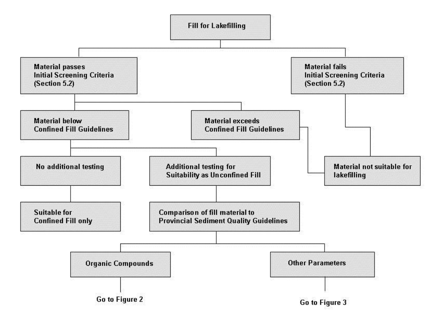
This figure provides the first part of a flow chart outlining decision points for determining the suitability of fill for identified uses. Decision pathways are as follows:
- If Material fails initial screening criteria as outlined in Section 5.2, the material is not suitable for lakefilling.
- If Material pass the initial screening criteria, but material exceeds confined fill guidelines, the material is not suitable for lakefilling.
- If Material pass the initial screening criteria, and pass the confined fill guidelines, the Material is suitable for Confined Fill, with no additional testing required.
- If Material pass the initial screening criteria, and the intent is for it to be used in Unconfined Fill, it must be compared to Provincial Sediment Quality Guidelines for Organic Compounds (See Figure D-2) and for Other Parameters (See Figure D-3).
Figure D-2: Site Specific Sediment Criteria for Organic Compounds
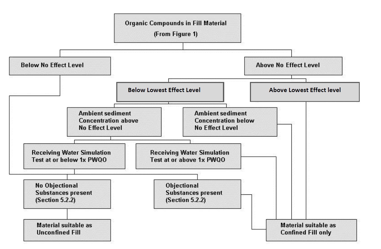
This figure is a continuation from Figure D-1, and is used to determine if fill is suitable for Unconfined Fill. Decision pathways are as follows:
- If Organic Compounds in Fill Material are below the Provincial Sediment Quality Guidelines No Effect Level and no Objectionable Substances (as per Section 5.2.2) are present, then the Material is Suitable for Unconfined Fill.
- If Organic Compounds in Fill Material are below the Provincial Sediment Quality Guidelines No Effect Level and Objectionable Substances (as per Section 5.2.2) are present, then the Material is Suitable for Confined Fill only.
- If Organic Compounds in Fill Material are above the No Effect Level, and above the Lowest Effect Level, then the Material is Suitable for Confined Fill only.
- If Organic Compounds in Fill Material are above the No Effect Level, but below the Lowest Effect Level, but Objectionable Substances (as per Section 5.2.2) are present, then the Material is Suitable for Confined Fill only.
- If Organic Compounds in Fill Material are above the No Effect Level, but below the Lowest Effect Level, and Objectionable Substances (as per Section 5.2.2) are not present, and the Material passes a Receiving Water Simulation Test where water concentrations are at or below the Provincial Water Quality Objective, then the material is suitable as Unconfined fill.
- If Organic Compounds in Fill Material are above the No Effect Level, but below the Lowest Effect Level, and Objectionable Substances (as per Section 5.2.2) are not present, but the Material does not pass a Receiving Water Simulation Test where water concentrations are at or below the Provincial Water Quality Objective, then the Material is Suitable for Confined Fill only.
Figure D-3: Site Specific Sediment Criteria for Other Parameters
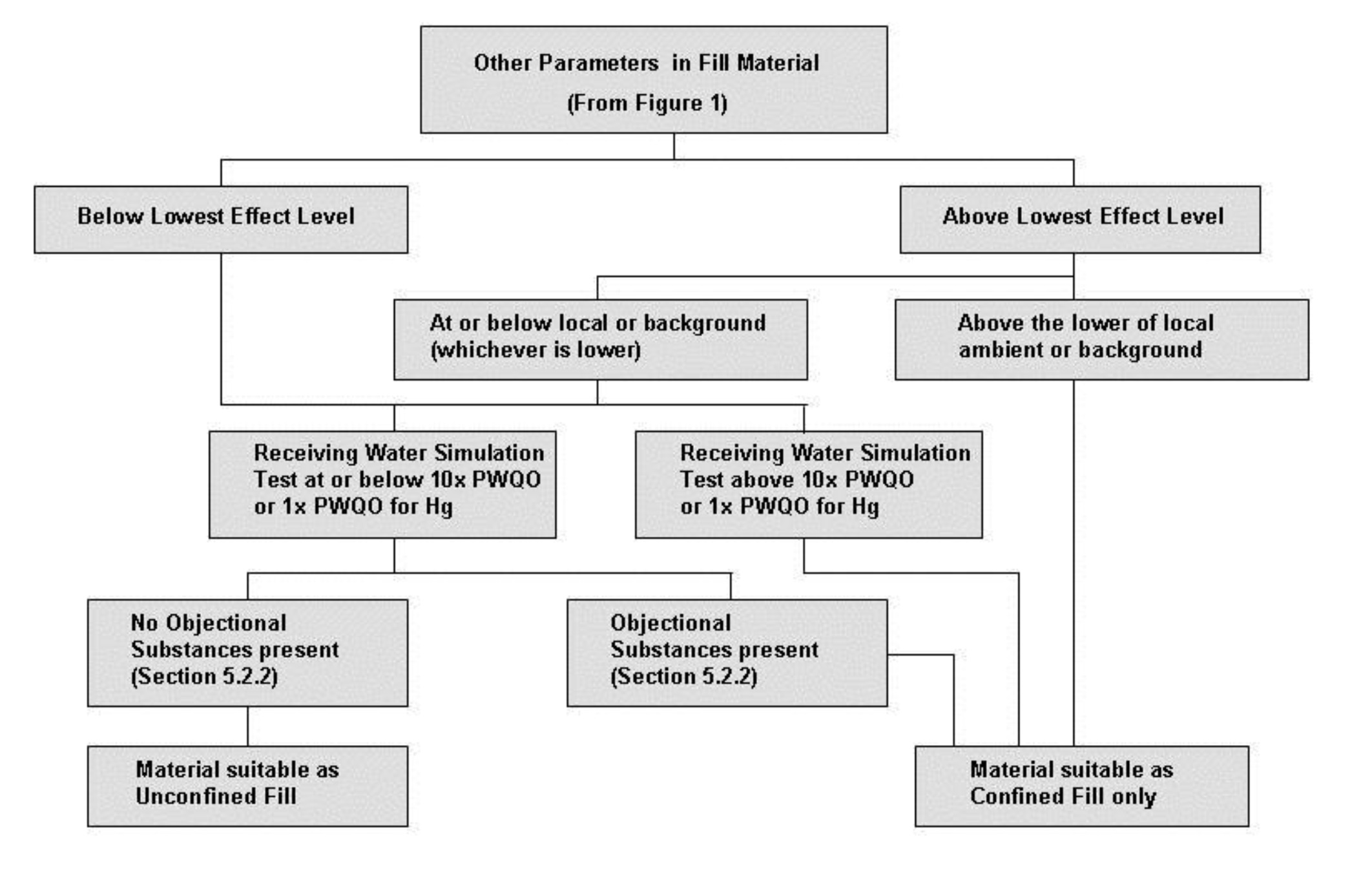
This figure is a continuation from Figure D-1, and is used to determine if fill is suitable for Unconfined Fill. Decision pathways are as follows:
- If Other Parameters in Fill Material are below the Lowest Effect Level, and Objectionable Substances (as per Section 5.2.2) are not present, and the Material passes a Receiving Water Simulation Test where water concentrations are at or below ten times the Provincial Water Quality Objective for the parameter (and below the Provincial Water Quality Objective for Mercury), then the material is suitable as Unconfined Fill.
- If Other Parameters in Fill Material are below the Lowest Effect Level, but Objectionable Substances (as per Section 5.2.2) are present, then the Material is Suitable for Confined Fill only.
- If Other Parameters in Fill Material are below the Lowest Effect Level, and Objectionable Substances (as per Section 5.2.2) are not present, but the Material does not pass a Receiving Water Simulation Test where water concentrations are at or below ten times the Provincial Water Quality Objective for the parameter (and below the Provincial Water Quality Objective for mercury), then the Material is Suitable for Confined Fill only.
- If Other Parameters in the Fill Material are above the Lowest Effect Level and above the lower of local ambient or background concentrations for that parameter, then the Material is suitable for Confined Fill only.
- If Other Parameters in the Fill Material are above the Lowest Effect Level and below the lower of local ambient or background concentrations for that parameter and the Material passes a Receiving Water Simulation Test where water concentrations are at or below ten times the Provincial Water Quality Objective for the parameter (and below the Provincial Water Quality Objective for Mercury), then the material is suitable as Unconfined Fill.
- If Other Parameters in the Fill Material are above the Lowest Effect Level and below the lower of local ambient or background concentrations for that parameter, but the Material does not pass a Receiving Water Simulation Test where water concentrations are at or below ten times the Provincial Water Quality Objective for the parameter (and below the Provincial Water Quality Objective for mercury), then the Material is Suitable for Confined Fill only.
ISBN 0-7729-9329-7 PIBs 8317
Footnotes
- footnote[1] Back to paragraph Caveat: Although this Guide and Good Management Practices may assist proponents and regulators in determining whether or not a proposal may result in unwanted environmental effects, use of this Guide and Good Management Practices does not exempt proponents of proposed projects from current evaluation procedures or approval requirements under legislation administered by the Ministry of the Environment, or by other Ministries or agencies. Proponents are responsible for complying with all pertinent laws and conforming with pertinent policies; federal, provincial, and/or municipal.
- footnote[2] Back to paragraph “Erosion hazards” in this policy means the loss of land, due to human or natural processes, that poses a threat to life and property.
- footnote[3] Back to paragraph The calm period on the Great Lakes is normally considered to extend from June through August when the climatic conditions are least likely to generate any sustained high energy waves. This period may be extended on a case-specific basis if it can be demonstrated, based on climatic records (i.e., wind and wave data) (Ontario Ministry of Natural Resources, 1988a, b, and c), that the occurrence of significant waves greater than 0.5m will occur with an expected probability of < 25%.
- footnote[4] Back to paragraph Classification criteria for fill were originally developed in conjunction with the 1997 Guideline for use at contaminated sites in Ontario and updated as Tables 1 and 2 in the 2009 Ministry of the Environment publication Soil, Ground Water and Sediment Standards for Use Under Part XV.1 of the Environmental Protection Act. A single series of analytical tests is used for material classification. Material is tested using bulk sediment analysis and results are reported on a dry weight basis (see Sampling and analytical protocols found in the 1996 Guideline for use at contaminated sites in Ontario and in the 1997 Guidance on sampling and analytical methods for use at contaminated sites in Ontario with analytical methods updated in 2004 Protocol for analytical methods used in the assessment of properties under Part XV.1 of the Environmental Protection Act.
- footnote[5] Back to paragraph A description of analytical methods and site sampling is provided in Ontario Ministry of the Environment. 2004 [amended as of July 1, 2011]. Protocol for analytical methods used in the assessment of properties under Part XV.1 of the Environmental Protection Act.
- footnote[6] Back to paragraph “Qualified persons” - as defined and described by Ontario Regulation 153/04 (i.e. Records of Site Condition - Part XV.1 of the Environmental Protection Act).
- footnote[7] Back to paragraph This test is a modification of the standard elutriate test and is used to assess whether contaminants may be released into water.
- footnote[8] Back to paragraph Turbidity is comprised of suspended particulates and colour. Though components of turbidity can be individually measured, turbidity is commonly measured using a Nephelometer and is expressed in Nephelometric Turbidity Units (NTUs) – a measure of spectral absorption. A less quantitative but rapid field method for comparatively assessing relative turbidity in still water employs a Secchi Disk with measurements expressed as a vertical depth to disappearance of the Disk.
- footnote[9] Back to paragraph The definition of soil textural types which follow are those used in Ontario Reg. 153/04 (as amended), s. 42 (2); O. Reg. 511/09, s. 19. "Coarse textured soil” means soil that contains more than 50 per cent by mass of particles that are 75 micrometres or larger in mean diameter. "Medium and fine textured soil” means soil that contains 50 per cent or more by mass of particles that are smaller than 75 micrometres in mean diameter