Advisory group report on protecting the Muskoka River Watershed
Read the Muskoka Watershed Advisory Group’s interim report on issues and priorities for protecting the watershed and supporting the local economy.
June 29 2020
The Honourable Jeff Yurek
Minister of the Environment, Conservation and Parks
777 Bay Street, 5th floor
Toronto, Ontario M7A 2J3
Re: 2020 Report of the Muskoka Watershed Advisory Group
The Muskoka Watershed Advisory Group is pleased to provide you with its report containing interim advice and recommendations in support of the development of the Muskoka Watershed Initiative. We celebrate the opportunity this Initiative offers to ensure the ecological health and sustainable future of the Muskoka River Watershed. We believe the advice and recommendations contained in this report may be used to inform work being done in other jurisdictions to help protect the province's water resources and pass on a cleaner environment to future generations.
The recommendations of the Muskoka Watershed Advisory Group are comprised of 19 distinct projects that fall into three broad categories:
- Integrated Watershed Management: The Primary Recommendation
- Flood Mitigation to Address Spring Flood Risk: The Most Pressing Need
- Specific Projects for Enhanced Watershed Health
The Advisory Group views the implementation of Integrated Watershed Management (IWM) as its most important recommendation. IWM presents the best approach for management of the complex and interrelated issues facing the Muskoka River Watershed, including spring flood risk as a specific concern. We recommend the Province take a leadership role in supporting the implementation of IWM and the collaborative approach it will require.
The Advisory Group notes the high level of interest expressed by the public in having the opportunity to read the advice and recommendations contained in this report and encourages the Minister to consider its timely release. During its outreach the Advisory Group received feedback from many entities, organizations and individuals, that there is great interest in seeing this report released in full to the public.
The Advisory Group would be pleased to offer a call or meeting with the Minister to walk through the report and answer any specific questions. We appreciate the opportunity to have contributed to the development of the Muskoka Watershed Initiative, and have recommended for your consideration a continuing role for our work including; support of the scoping, definition and implementation of any projects at the request of the Minister, assistance in identifying municipal, federal and private funding opportunities and the fulfillment of any community engagement requests at the request of the Minister.
Sincerely,
Mardi Witzel
Chair, Muskoka Watershed Advisory Group
Members of the Muskoka Watershed Advisory Group: All members served as co-authors
- Mardi Witzel, Chair
- Don Smith, Vice-Chair
- Patricia Arney
- John Beaucage
- Julie Cayley
- Chris Cragg
- John Miller
- Kevin Trimble
- Norman Yan
Acknowledgements
We are grateful for the support received from Ling Mark, Madhu Malhotra, Neil Levesque and Tahseen Chowdhury of the Ontario Ministry of the Environment, Conservation and Parks, and for the contributions provided by Dr. Andrew Paterson, Erin Cotnam, Chris Near and Dr. Barb Veale in assisting us with our work over the past ten months and in the preparation of this report.
In addition we would like to acknowledge the efforts and interest of the many local municipal representatives, First Nations, community organizations and members of the public who took the time to attend our listening sessions and provide valuable input to our process.
A special word of thanks is extended to the Honourable Jeff Yurek, Minister of the Environment, Conservation and Parks, for recognizing the importance of long-term watershed health, and inviting the Muskoka Watershed Advisory Group to provide advice and recommendations in support of the development of the Muskoka Watershed Initiative.
Disclaimer
This report has been completed in accordance with the Muskoka Watershed Advisory Group terms of reference as established by the Minister of the Environment, Conservation and Parks. This report represents the input and advice of a diverse group of individuals, and the recommendations contained within represent a consensus perspective, where consensus refers to general agreement which may not be entirely unanimous.
Executive summary
In August 2018, the Ministry of the Environment, Conservation and Parks ("Ministry" or "MECP") announced the creation of the Muskoka Watershed Conservation and Management Initiative ("Muskoka Watershed Initiative" or "Initiative"). The purpose of the Initiative is to better identify risks and issues facing the Muskoka region, allowing the community and the Province to work together to protect the environment and support economic growth. The Muskoka Watershed Initiative will help to protect the province's water resources and pass on a cleaner environment to future generations.
To assist the government in delivering the Muskoka Watershed Initiative, the Ministry created the Muskoka Watershed Advisory Group ("Advisory Group"), comprised of nine volunteers representing a cross-section of education and experience backgrounds and with deep roots in the Muskoka community. The Advisory Group is charged with providing advice and recommendations to the Minister of the Environment, Conservation and Parks regarding the Muskoka Watershed Initiative, specifically a strategic assessment of priority issues and the types of projects that could be undertaken in the Watershed.
The advice and recommendations of the Advisory Group, contained in this report, have been prepared following an extensive period of community outreach with over 60 distinct entities including municipal governments, First Nations, lake associations, stewardship organizations, economic stakeholders, waterpower producers, local planners and consultants, local educators, representatives from the local agricultural industry and members of the general public. The Muskoka Watershed Advisory Group has chosen to focus its efforts on the Muskoka River Watershed (the "Watershed") and its 15 sub-watersheds, but highlights here the belief that many of the recommended projects can be leveraged into other watersheds across the province.
The Advisory Group was announced in August 2019, on the heels of a devastating "100 year" spring flood in Muskoka. During outreach, the Initiative's aspiration for a 'broader, more comprehensive approach to watershed management in Ontario' was reinforced. The message got through. While the community had lots to say about flooding, what is striking is the number and breadth of issues raised – over 200 raw issues. These were examined and distilled into a smaller number of issue categories for discussion.
Following from the Advisory Group's terms of reference, the identification of issues and threats is understood to be for the purpose of protecting the environment while supporting economic growth. On this basis, it was determined that the group would focus on the identification of environmental and/or ecological issues, then discuss and prioritize them according to environmental, economic and social impacts.
Issues of the Muskoka River Watershed
The Muskoka River Watershed environment is changing. Evidence of this is seen in changed patterns of weather and precipitation, increases in the incidence of flooding and major storms, the presence of invasive species and diseases affecting our forests and wildlife and the challenge of new and poorly understood threats to the quality of our water. These changes are largely the result of climate change and/or human development projects that have altered the natural environment. In this sense, climate change and land use practices are viewed as causal factors or issues that create and then interact with other issues.
Four environmental issues top the list facing the Muskoka River Watershed:
- Increased incidence, severity and risk of flooding
The 2019 Watershed flood event represented the second '100 year flood' in Muskoka, and the third flood, in six years (2013, 2016 and 2019). In order to develop flood mitigation strategies to protect the existing high-value built infrastructure, there needs to be a clear understanding of the root causes of fluctuating water levels in the Muskoka River. This is important due to the extensive environmental and socio-economic costs of flooding. - Increased incidence of erosion and siltation
Erosion and siltation occur due to fluctuating water levels throughout the Watershed, and in some cases become severe enough to damage infrastructure, impede navigation, potentially harm water quality and devalue property. The root causes of erosion and siltation are not constant but reflect the varying geological conditions and patterns of water level fluctuations experienced. There is a need for both remediation and further study. - Existing and emerging threats to water quality
Both expert opinion and community input suggests water quality is generally very good in the Muskoka River Watershed, but there are existing and emerging threats. There was considerable overlap from multiple sources, highlighting five specific threats to water quality in the Watershed; widespread calcium decline, sometimes called 'ecological osteoporosis,' increasing levels of road salt in our waters, emerging contaminants, phosphorus from septic systems and hazardous algal blooms (HABs), especially blue-green algae blooms. - Existing and emerging threats to biodiversity and natural habitat
The Muskoka River Watershed is rich in natural resources and biodiversity which are key to ensuring a healthy environment, strong communities and a thriving economy. Habitat and biodiversity are interconnected with virtually all other issues facing the Watershed. After discussion and analysis of the issues, the Advisory Group identified the following existing and emerging threats: erosion, fragmentation/loss of corridors, invading species, loss of biodiversity, loss of forest health, loss of stream networks, threatened species and wetland loss.
In addition to environmental concerns, two management issues top the list:
- Watershed governance
- Land use policy
The work of the Advisory Group suggests the existing set of land use policies has contributed to the rise of environmental issues in the Watershed today. In terms of governance, the Advisory Group finds that the current fragmented approach to analysis, decision-making, programming and communications in the Watershed does not serve it optimally. There is variance in the extent to which these issues generate impacts on environmental, ecological, economic and/or social grounds, but in all cases the impact is significant.
Types of projects for the Muskoka River Watershed
The recommendations of the Muskoka Watershed Advisory Group fall into three broad categories:
- The most important recommendation: integrated watershed management
- The most pressing need: flood mitigation to address spring flood risk
- Specific projects for enhanced watershed health
Reflecting the complex and interrelated nature of issues, the Advisory Group recommends a fundamental and overarching solution is needed for the Muskoka River Watershed and this can best be provided through Integrated Watershed Management (IWM). IWM is needed to fully address the interconnected causes of our most urgent and critical issues today. IWM also offers an approach for long-term resolution, incorporating future land use practices and the ongoing effects of climate change through a coordinated watershed-wide approach.
IWM is the most important overall "project type" to initiate in order to achieve the province's goals of better identifying risks and issues facing the Muskoka River Watershed, and ultimately providing solutions. Because this is a relatively longer-term, large-scale process, and recognizing the presence of a number of urgent and pressing concerns today, in developing its advice and recommendations, the Advisory Group has taken the approach that some project types will initiate the large-scale, long-term IWM approach while other high priority project types will be geared toward more specific issues with two interrelated objectives: a) contributing to key steps in the IWM planning process and b) providing shorter-term solutions to specific issues.
Integrated watershed management: evidence-based decision-making
According to an IWM White Paper prepared by the Muskoka Watershed Council (MWC), "Typical environmental management proceeds as a set of separate, siloed tasks undertaken by different tiers of, and departments within government, and different sectors of society. Integrated Watershed Management (IWM) is organizationally more complex; introducing IWM requires significant commitment from participating levels of government, ministries, agencies, and all community sectors, if it is to be successful. At its simplest, IWM brings a science-based, ecological perspective to environmental and land use management, recognizing that the broad range of ecological processes operates across landscapes, and that management is best done on the same scales and using natural boundaries without regard to municipal boundaries."
Ultimately, IWM provides an evidence-based approach by which land use decisions, environmental projects, infrastructure projects and broader public policy options can be assessed in terms of their impacts. In this sense, IWM provides a tool by which policymakers and watershed managers can evaluate the merits of proposed interventions in both environmental and economic terms. IWM provides a best-in-class approach to facilitating management decisions that are effective at sustaining natural capital and supporting current economies and lifestyles.
Flood mitigation: the most pressing need
The Advisory Group recognizes the significant costs of flooding in the Muskoka River Watershed in recent years, and the sense of urgency around developing approaches to flood mitigation. Flooding exerts environmental, social as well as economic costs, and flood mitigation is the most pressing current need facing the Muskoka River Watershed. A set of short-term and medium-term recommendations for flood mitigation that reflect the work of the Ontario Flood Advisor are presented here.
These flood mitigation strategies build upon the plans set out in the Ontario Flood Strategy, offering recommendations specific to the Muskoka River Watershed. In particular the recommendations in this report around flood mitigation address three priorities outlined in the Ontario Flood Strategy – Understand Flood Risks, Strengthen Governance of Flood Risks and Invest in Flood Risk Reduction. Building upon these strategic provincial plans, the project types recommended in this report call for the creation of a Flood Mitigation Mandate to be assumed by a newly formed technical Water Quantity Task Force in the Muskoka River Watershed. The strategies for flood mitigation are captured in recommendation 8.
Specific projects for enhanced watershed health
A number of specific projects are recommended to enhance watershed health on a wide range of watershed issues. The Advisory Group recommends these specific types of projects be started in parallel with the large-scale undertaking of IWM, both because these issues should be addressed, and because their results will improve the ability of IWM to recommend more effective watershed management decisions. Recommendations 9 through 19 lay out the specific projects designed to enhance watershed health.
Concluding comments
The Muskoka Watershed retains many natural features, and its forests and 2000+ lakes make it a highly-valued environment, and according to National Geographic, one of the world's premier recreational destinations. Approximately 82% of the Watershed retains natural cover, with high biodiversity and functional ecological systems that support a number of species at risk. The MWC Report Card from 2018 reports that 18% of the watershed has been extensively modified for human uses. Nonetheless, it speaks to the general health of the Watershed that town residents sometimes have to sidestep deer, bear and the occasional moose in their communities.
Past scientific research on Muskoka lakes has changed the ways problems in lakes are understood and managed around the world. Without the scientific services provided by Muskoka lake scientists, our lakes and our use and appreciation of them would have suffered, dragging down our economy in consort. This is going to be even more true going forward with the pressures of climate change and development.
There's an Anishinabek teaching that speaks to the place that human beings hold in creation:
All of creation was in place before humans were put on the earth. Everything that we see walking, flying, swimming or crawling was here before us. All of creation can exist and thrive without human beings. One of the gifts that we were given was the ability to exert control over our immediate surroundings, to make life easier and more comfortable for us. In exerting that control, it is essential that we remind ourselves that if we throw our immediate environment out of balance, we may also make life impossible for ourselves and for those creatures weaker than ourselves. So as we develop, build things, change our environment to suit ourselves, we must take heed to look after the little creatures. If our actions destroy them, we are in a way destroying ourselves. If we think about how to preserve life no matter how small and insignificant, we are looking after ourselves and our descendants. All of our decisions must take into consideration how it will affect events seven generations from now.
The Advisory Group has been honoured and inspired to volunteer through this phase in support of the development of the Muskoka Watershed Initiative.
Recommendations
Integrated watershed management
Flood mitigation
Specific projects
Beyond the overarching project type aimed at streamlining the existing water quality programs, the following sub-projects are recommended for program enhancement:
Introduction
The Muskoka Watershed Initiative
In August 2018 the Ministry of the Environment, Conservation and Parks ("Ministry" or "MECP") announced the creation of the $5 million Muskoka Watershed Initiative (MWI). The purpose of the MWI is to better identify risks and issues facing the Muskoka region, allowing the community and the Province to work together to protect the environment and support economic growth. The MWI will help to protect the province's water resources and pass on a cleaner environment to future generations.
In addition to the $5 million, the Province will also match tax-deductible donations to the MWI, from individuals, businesses, and/or other levels of government up to an additional $5 million for a potential total fund of $15 million.
To assist the government in delivering the MWI, the Ministry created the Muskoka Watershed Advisory Group ("Advisory Group"). The purpose of the Advisory Group is to collaborate with and support the Ministry in the development and implementation of the Initiative.
The Muskoka Watershed Advisory Group has chosen to focus its efforts on the Muskoka River Watershed (the "Watershed"), which consists of 15 sub-watersheds located primarily within the District of Muskoka. The Watershed measures about 62 km by 120 km, and discharges into Georgian Bay via the Moon River. In conceiving the MWI, the Ministry recognized the Watershed is facing pressures due to increased development, severe weather events resulting from the changing climate, increasing contaminants such as nutrients and chloride, management of species at risk and invasive species, and shoreline erosion. There is acknowledgement that local residents are concerned about water quality and water quantity management and the impacts of flooding.
The advice and recommendations of the Advisory Group have been prepared following an extensive period of community outreach. With this report, we advance actionable recommendations that may offer short-term relief from pressures, but as importantly, we make specific recommendations toward a proactive longer-term solution – the development of a comprehensive approach to watershed management in Muskoka. The recommended approach is Integrated Watershed Management, which recognizes the Muskoka River Watershed has extensive natural infrastructure as well as man-made control systems, and that both play a critical role in the Watershed's health and functioning.
Terms of reference
The Advisory Group was established in August 2019 to provide advice and make recommendations to the Minister of the Environment, Conservation and Parks regarding implementation of the Muskoka Watershed Initiative.
Specifically, the mandate of the Advisory Group includes the following:
- Provide advice and make recommendations to the Minister regarding: priority areas, priority issues to be addressed and the types of projects that could be undertaken in the watershed
- Assist in identifying municipal, federal and private funding opportunities
- Participate with the Ministry in public and indigenous engagement efforts regarding the Muskoka Watershed Initiative, upon request from the Minister
- Communicate with local organizations and communities represented by the Advisory Group and bring these perspectives forward during Advisory Group meetings (subject to confidentiality provisions of the terms of reference)
In this report, the Advisory Group addresses the first and last of these tasks.
Background
Muskoka River Watershed
The Muskoka River Watershed retains many natural features, and its forests and 2000+ lakes make it a highly valued environment. According to National Geographic, Muskoka is one of the world's premier recreational destinations.
The Muskoka River Watershed is located in Ontario Shield Ecozone Ecoregion 5E (Georgian Bay Ecoregion). Its headwaters originate in Algonquin Park and flow southwesterly for approximately 210 km, into the southeast corner of Georgian Bay. The Watershed measures approximately 62 km in width by 120 km in length, and encompasses an area of approximately 5,100 sq km. Three main drainage areas exist within the Watershed; the North Branch, the South Branch and Lower Muskoka. The combined flow for all three drainage areas passes through Lake Muskoka at Bala, then down the Moon and Musquash Rivers and ultimately discharges into Georgian Bay.
The list below captures key development and use characteristics of the Muskoka River Watershed:
- Approximate permanent population: 61,200
- Approximate seasonal population: 82,300
- Number of municipalities (part or whole):
- 13 area municipalities
- District of Muskoka
- County of Haliburton
- Number of major towns: 3 (Bracebridge, Gravenhurst, Huntsville)
- Number of villages and hamlets: 11
- Number of municipal wastewater systems: 8
- Number of water control structures: 42
- Number of navigation locks: 3
- Number of hydro generating stations: 11
The paragraphs below provide characteristic highlights of the Muskoka River Watershed, referencing the work and reporting of the Muskoka Watershed Council.
Physiography and topography: The Muskoka River Watershed lies on the Canadian Shield and has as key features ancient, weathered, sparingly-soluble granitic bedrock, overlain by thin glacial tills. The topography is varied, ranging from the rugged highlands of the Algonquin region, to rocky knolls and ridges throughout the middle and lower portions of the Watershed, and small areas of flat, open farmland. While soils are typically sandy and shallow (typically only 10 to 30 cm) atop the bedrock foundation, smaller areas of deeper deposits of sand, silt and clay can be found in the valleys in the centre of the watershed. The Watershed is heavily forested, with second or third growth mixed hardwood and coniferous species. A few patches of old growth forest remain in inaccessible areas of Algonquin Park.
All of Canada was under ice 20,000 years ago, and glaciers receded from Muskoka about 10,000 years ago, leaving a very altered landscape. All the forests and much of the soil were removed exposing the pot-holed bedrock. This coupled with the fact that Muskoka receives about 1 metre (water equivalent) of rain and snow a year, only half of which is lost to evaporation and transpiration, meant that all the depressions filled with flowing water that supported a few arctic imports, including the lake trout. It is this glacial history and climate that gave Muskoka the lakes that have made it so popular.
Climate: The Watershed experiences cool to moderate temperatures and is one of the wetter areas in the province. The average annual precipitation is roughly 1,000 mm of water equivalent, including nearly 3,000 mm of snowfall. But these past averages may not last. Global climate change is likely to alter Muskoka climate by mid-century making it warmer and slightly wetter than at present, with the prospect of more extreme precipitation events.
Fisheries: Roughly 30 species of fish inhabit the Muskoka River Watershed, mainly cool and cold-water fish species such as Lake and Brook Trout, Yellow Perch, and the predators Smallmouth Bass, Walleye, Northern Pike, Muskellunge. Bass populations are predicted to increase with a warming climate, and pike introductions are a concern for some that prefer native fish assemblies. Many of the important fish spawning areas in the system are located below the many rapids and dams, and along lake shorelines. These critical habitats can be affected by fluctuating water levels and flows and by erosion and siltation associated with removal of riparian vegetation.
Wildlife: The Muskoka River Watershed is home to a diversity of mammal, reptile, amphibian and bird species. According to the Vital Signs Report, 250 species of birds, 50 species of mammals and 35 species of reptiles and amphibians call Muskoka home. The life cycle, health and abundance of these species is influenced by how we treat land cover in forests in riparian zones and nearshore waters. The lakes, rivers, wetlands, forests and soils comprise a linked complex on which native species are dependent for habitat and food.
Settlement: With the retreat of the last glaciers, the Muskoka region would have been cold, forbidding, and difficult to populate for quite some time. By about 5,000 years ago, before the building of the pyramids in Egypt, the Watershed was inhabited by First Nations; first the Algonquin, then Iroquois, and by the mid 18th century, the Ojibway. European settlers were drawn to the area by the timber industry in the mid-to-late 1800s, and the first sawmill was built in 1865. The first tanneries came to Muskoka at roughly the same time, and by the late 1800s, Muskoka supported some of the largest tanneries in Canada.
Settlers were also drawn to Muskoka by land grants under the 1860 Public Lands Act. Many intended to farm until they were deterred by the poor soils, abundance of rock and many swamps. They then turned to renting rooms to visiting hunters and fishermen. This led to construction of many seasonal hotels between 1880 and 1900, to accommodate the "tourists", several of which still operate today.
Muskoka is also distinguished by its many islands and – thanks to the water regulation by its many dams – by stable water levels during the summer "navigation season". This encouraged many cottagers to acquire wooden boats for personal transport and to construct boathouses for summer and winter storage of these boats. Muskoka's wooden boatbuilders are internationally famous and its boathouses make the region unique. Today Muskoka is home to approximately 60,000 permanent residents and slightly over 80,000 seasonal residents.
Hydroelectric power generation: Hydroelectric power production has been and continues to be an important part of the local economy. Today, there are eleven hydroelectric generating stations in the Muskoka River Watershed; four owned by Ontario Power Generation (OPG), three by Bracebridge Generation, two by Orillia Power and one by Swift River Energy Limited (SREL). These facilities cooperate with the Ministry of Natural Resources and Forests (MNRF) in the control and management of water levels and flows in the Muskoka River and operate under the Muskoka River Water Management Plan 2006 (MRWMP).
Economic and social: Cottaging and tourism are the two largest economic drivers in the Watershed today. Tourists, seasonal and permanent residents contribute to the economic base through the consumption of goods and services. Commercial and business operations within the Watershed are concentrated along transportation corridors, in the three town centres of Bracebridge, Gravenhurst and Huntsville and in proximity to the lakes and their shorelines. The scale of the economic impact of seasonal residents in the Muskoka Watershed is huge. The District of Muskoka acknowledges the role of seasonal residents as a significant component of the District's economic backbone, and in 2016 the economic impact of seasonal resident expenditures was estimated to be $421 million.
The Vital Signs Report reveals a study in contrasts, opportunity and challenges. A strong but mainly seasonal tourist economy is evidenced by the three million person visits to Muskoka which occurred in 2016, two-thirds of which took place between July and September. In that year total visitor spending exceeded $500 million in the District of Muskoka. The 2016 report also underscored the socio-economic challenges in Muskoka; median employment income was 21% below the provincial average, 13% of Muskoka residents were living in poverty, 25% of households were spending more than 30% of their income on shelter costs and 43% of all jobs were in sectors where the work is largely seasonal.
In addition to the two key economic drivers of tourism and cottaging, Muskoka has a long tradition of other industries and adapting to develop new opportunities. In its earliest days, Muskoka was home to a significant lumbering and wood processing industry that depended on the Watershed for harvesting logs, generating power and shipping product. Today, locally-developed industries serve not only the local population but supply other markets. Significantly, Muskoka is located just north of almost 9.25 million people – over 68% of Ontario's population – living in the Greater Golden Horseshoe region. Muskoka manufacturers ship everything from electronics products to refined aggregates throughout the country and to international markets. From 1-Gigabit fibre-optic internet to a Canada Customs Airport of Entry, Muskoka is connected to the world.
Muskoka also has a growing public service sector, strong real estate and construction sectors
In 2011 and 2012, National Geographic rated Muskoka as one of the top destinations in the world to visit. The beauty of Muskoka's physical environment and its 'over 1000 lakes' was noted, with the area being characterized as a 'natural playground' that was both accessible and capable of offering an 'unplugged pace.'
Community outreach
The Advisory Group is comprised of nine volunteers representing a cross-section of educational and experience backgrounds, all with deep roots in the Muskoka community. A first meeting was held in September 2019 in Bracebridge, Ontario. By early October 2019, a preliminary project plan had been developed including a list of community outreach targets, and initial outreach sessions were being scheduled. The Advisory Group's first outreach meeting was held on October 28, 2019.
Early-on, the Advisory Group determined it would seek to augment members' understanding and knowledge of the issues and opportunities facing the Muskoka River Watershed with those from a wide range of local organizations. Therefore, input was solicited from anyone in the community who chose to provide it. From October 2019 through April 2020, the Advisory Group held one-on-one sessions, small meetings and larger listening sessions. Outreach included meetings with representatives from municipal government, First Nations, lake associations, local stewardship organizations, economic stakeholders, waterpower producers, local planners and consultants, local educators, representatives from the local agricultural industry and members of the general public. In addition to hosting a community listening session where over 100 members of the public attended, Advisory Group members met with over 60 distinct organizations/entities.
Several listening sessions were noteworthy in this phase of our process:
Municipal listening session, November 2019
The Advisory Group held a Listening Session in Bracebridge, Ontario, where the chair of the District of Muskoka and all thirteen of the municipalities (Mayor, Chair, Reeve) that touch the Muskoka River Watershed were invited. Representatives from the District and seven municipalities attended.
Community listening session, January 2020
The Advisory Group held an open Community Listening Session in Port Carling, Ontario, where the general public was invited to attend. The event was promoted in the weeks prior through a press release to media outlets, via the District of Muskoka's 'Bang the Table' social media channel and through the efforts of two larger community organizations: the Muskoka Lakes Association (MLA) and the Federation of Ontario Cottager's Associations (FOCA). Over one hundred people attended.
First Nations listening sessions April 2020
A First Nations Listening Session arranged for March 2020 was cancelled due to COVID-19 restrictions on travel and social distancing. The Advisory Group held teleconference listening sessions with First Nations and the Metis Nations of Ontario in April 2020. Participating representatives also carried information on the work and mandate of the Advisory Group back to their communities and invited broader input.
In order to facilitate submissions from the community the email account muskokawatershed.ag@gmail.com was set-up, and subsequently promoted through a press release and social media. Local organizations and members of the public were encouraged to attend the January 2020 Community Listening Session and/or submit questions, comments or full submissions to the Advisory Group using the Gmail account.
All input received from local organizations, including emails from the general public, was made available to the Advisory Group as a whole, and one member maintained a spreadsheet cataloguing this input according to a range of analytic criteria established by the group.
A list of the organizations with whom the Advisory Group met with and/or from whom input was collected is captured in Appendix B. A summary of input received is captured in Appendix C.
Issue identification and prioritization
Issue identification
In January 2020, a working sub-group was formed to address the question of how to prioritize issues. As a starting point, it was agreed that issues should be qualified according to our terms of reference, prior to any attempt to prioritize them.
In the context of the Muskoka Watershed Advisory Group terms of reference, the identification of issues and threats is understood to be for the purpose of protecting the environment while supporting economic growth. On this basis, it was determined the group would focus on the identification of environmental and/or ecological issues and prioritizing them according to environmental, economic and social impacts.
Therefore, it was determined that a problem or threat may constitute a "qualified issue" if the issue relates to health and/or management of the Muskoka Watershed and any one of the following is true:
- The issue presents a known risk or threat to Muskoka River Watershed environmental and/or ecological health
- The issue presents a suspected risk or threat to Muskoka River Watershed environmental and/or ecological health
- The issue presents a significant departure from historical and/or desired environmental or ecological behavior such that it is deemed a "prospective threat" to the Muskoka River Watershed
- The issue presents a risk or threat to effective management of the Muskoka River Watershed
Of the many issues surfaced during outreach, most were found to be relevant to the group's mandate, but a few were determined to fall outside the terms of reference. In addition, a considerable number of issues that were raised through our outreach were eventually determined to be projects or potential solutions to problems, rather than the problems themselves. Lastly, a smaller number of issues were decreed to be true issues but were determined to be significant also as underlying causes to other issues. The work of the Advisory Group distinguishes between these two types of issues – symptoms and underlying causes – in the interest of treating both where possible.
Issue prioritization process
The working sub-group on issue prioritization developed a screening tool incorporating environmental, economic and social impact measures for review by the Advisory Group as a whole. Beginning in late February 2020 and continuing into April 2020, the Advisory Group undertook a review of all input received. Over 200 individual 'raw unqualified issues' had been raised through the outreach process. In this phase, the Advisory Group reviewed the input received, brought the perspectives of the community forward into discussions and began to identify, evaluate and prioritize the issues facing the Muskoka River Watershed.
Ultimately, issues were prioritized by qualitative methods, considering input from the community and a consideration of environmental/ecological, economic and social impacts informing the discussion of the Advisory Group.
Issues in the Muskoka River Watershed
While the Muskoka Watershed Initiative was announced by the Province in August 2018, the real activity from the public's perspective didn't start until August 2019 with the introduction of the Advisory Group. Getting to work in September 2019, on the heels of the devastating spring 2019 flood in Muskoka, the Advisory Group was mindful of the full range of emotions and frustrations around water levels and water levels management. Despite the terms of reference for the Muskoka Watershed Initiative citing the need for a "broader, more comprehensive approach to watershed management in Ontario," it was recognized many people would see the group as a flooding task force. Over the course of many months of outreach, Advisory Group members were careful to explain the mandate and solicit input reflecting its breadth. Repeatedly, it was explained issues relating to water levels and flows were an important element of the work, but not the sole focus, and matters related to water quantity would be considered as part of the Watershed's ecological system in totality.
The cumulative input from these outreach efforts indicates this message really got through. While the community had lots to say about flooding, what is striking about the input received, is the number and breadth of issues raised. Over 200 raw issues were raised by the public, by community organizations, civic leaders and First Nations and Metis Nations. The raw list of issues was examined and distilled into a smaller number of issue categories and discrete issues.
Table 1 captures the list of issues and issue categories upon which prioritization discussions were founded:
| Category | Issue |
|---|---|
| Water quantity-related |
|
| Water quality-related |
|
| Loss of natural assets |
|
| Climate change |
|
| Watershed management |
|
| Land use policy |
|
The changing Muskoka environment
The Muskoka River Watershed environment is changing. Evidence of this is seen in changed patterns of weather and precipitation, increases in the incidence of flooding and major storms, the presence of invasive species and diseases affecting our forests and wildlife and the challenge of new and poorly understood threats to the quality of our water. These changes are largely the result of climate change and human development projects that have altered the natural environment. In this sense, climate change and land use practices are Muskoka River Watershed issues of a distinct type; they are underlying causal factors, or issues that create and then interact with other issues.
A 2016 Muskoka Watershed Council (MWC) study took data from the Intergovernmental Panel on Climate Change (IPCC) to make predictions for mid-century temperature and precipitation patterns in Muskoka. The predictions suggest Muskoka will experience warmer temperatures overall, with wetter winter/springs and drier summer/falls. The impacts of these shifts on the environment in the Watershed could be significant; greater risks of spring flooding, summer drought and fire, drier soil and wetland loss, changing zones of optimal growth of key forest tree species, increased probability of water quality issues, including algal blooms, and threats to the delicate balance of native species. The prospect of these changes is a beacon call for sound science, data and the tools to monitor, diagnose and manage the Watershed.
The topic of land use policy and development arose frequently in discussions of Muskoka River Watershed issues and health. The oft-cited tension between economy and environment was typically flipped on its head, with arguments the best way to grow the Muskoka economy and grow the tax base is by doing a better job of preserving and protecting the Watershed. A prevailing theme is the community's desire for future land use decisions to be subjected to a more rigorous and comprehensive evaluation of environmental and ecological impacts, including cumulative impacts. This is not to suggest an anti-development sentiment, but rather a zealous desire to avoid doing irreversible harm to the Watershed through over-development and irresponsible development.
To the extent the changes taking place in Muskoka's natural environment are attributable to climate change and land use policy, these have been viewed as underlying or causal factors. The Advisory Group recognizes climate change as an issue for Muskoka, and in this vein acknowledges a pressing need to plan for the development of greater watershed resiliency going forward.
Four environmental issues top the list of issues facing the Muskoka River Watershed; increased incidence, severity and risk of flooding, increased incidence of erosion and siltation, existing and emerging threats to water quality, and existing and emerging threats to biodiversity and natural habitat. In all cases, both climate change and land use policy play a significant role. In addition, two management issues top the list – governance and land use policy. The work of the Advisory Group suggests the existing set of land use policies has contributed to the rise of environmental issues in the Watershed, today. The current fragmented approach to analysis, decision-making, programming and communications in the Watershed does not serve it well. There is variance in the extent to which these issues generate impacts on environmental, ecological, economic and/or social grounds, but in all cases the impact is significant. Each issue and its associated impacts are discussed below.
Priority issues in the Muskoka River Watershed
Increased incidence, severity and risk of flooding
The Muskoka Watershed Initiative and the Advisory Group were announced in August 2018 and August 2019, respectively. In the interim, the major floods of 2019 struck the Province and the Province took significant action by commissioning a Special Flooding Study by an Independent Advisor
Water levels, water level management and flooding continue to be a sensitive topic to shoreline residents of Muskoka through the spring of 2020. Despite an early and benign resolution to the 2020 year’s freshet by April 14th, considerable ire and angst were generated by the subsequent raising of water levels by 0.2 m among Lake Muskoka residents, particularly those in Bala Bay. Residents were angry because this water level rise was unexpected by them (even though levels were within the upper Normal Operating Zone (NOZ) of the MRWMP), because water levels approached those of the recent floods, and seasonal residents were unable to access their properties due to travel restrictions imposed by the COVID-19 pandemic.
In the spring of 2019, a series of heavy rains combined with rapidly melting snow from a near record snowpack to generate severe flooding conditions across much of Ontario. There was devastating flooding in Muskoka. In addition to record high water levels, sheets of ice remained on the lakes during the flood and high winds blew these into lakeside structures, intensifying the level of damage. The District of Muskoka and three local municipalities declared states of emergency as rising water levels resulted in damage to docks, shorelines, homes, boathouses and significant economic impacts to property owners and businesses. In 2013 the flooding was called the worst in a century, but the water levels in 2019 surpassed those from six years before. The 2019 flood event represented the third flood in six years.
Following a flood in 2016, the Muskoka Lakes Association conducted a survey which found hundreds of lakeshore property owners experienced damage, ranging from minor decking issues to major structural building impacts. The survey found $4M in estimated damages from 414 responses that provided damage repair estimates and projected that direct lakeside damages exceeded the $50M estimate for 2013.
An issue the Advisory Group heard repeatedly during outreach, is the lack of a "quarterback" for flooding. The Report of the Ontario Flood Advisor acknowledges this saying; 'while the MNRF generally takes the position that municipalities are exclusively responsible for identifying hazardous areas, provincial policy is unclear and at times contradictory, and has created some confusion over who is responsible for identifying hazardous areas.'
In Muskoka, there is no one entity or framework that brings together the role of hazard area identification with the liability for land use decisions. By extension, in Muskoka it is unclear who has the responsibility for investigating, developing and recommending flood mitigation strategies to protect existing infrastructure and the authority to implement such recommendations.
Understanding and addressing the root causes of flooding is important due to the extensive environmental and socio-economic costs of flooding. Flood damage to public infrastructure in urban areas – roads, bridges, buildings etc. – is costly for the municipalities. Boathouses and waterfront structures of significant value are not insured but bear the brunt of the flood damage either from water or ice or floating debris. Businesses from Huntsville to Bala were submerged, forcing closure and extensive renovations with the resultant loss of revenue and cost of repair and/or increased insurance rates.
Excellent water quality is one of the most valued natural assets of Muskoka and it is environmentally costly to have it repeatedly threatened by flooding which impacts too many septic systems, particularly older ones built closer to the shoreline than would be permitted today. Additionally, shoreline erosion and siltation caused by flooding has been identified as a significant 'issue' for this report.
In conclusion, flooding in the Muskoka River system has become more frequent and more severe in recent years. The economic and social impacts for residents and business owners are negative and profound. There are also environmental consequences to flooding in terms of shoreline erosion, siltation, disturbance of pollutants, septic system overflows and more. With the influence of a changing climate, people in Ontario can expect to see more floods and more droughts. This will be a major issue for Muskoka. Relatedly, the lack of clear leadership on the issue of flooding has resulted in growing skepticism of government agencies and other organizations involved and the communication of information about policies that may or may not be correct.
Increased incidence of erosion and siltation
The erosion of shoreline throughout the Muskoka River Watershed is a naturally occurring process, but human activity has compounded the significance of erosion in many areas, particularly on the open lakes. The recent flooding events of 2013, 2016 and 2019 have manifest new areas of concern from a perspective of erosion and siltation. In the area of the Muskoka River Delta at Bracebridge, exceptionally high water levels and flow volumes resulted in substantial erosion, damage to built infrastructure and silt deposits. The silt deposit has created navigational concerns for both recreational and commercial operators on the Muskoka River.
Since the earliest settlement of Muskoka, the Muskoka River has been a major waterway and transportation corridor. Steamships from Gravenhurst regularly travelled the river as settlement pushed northward. Today, pleasure boats are the dominant traffic on the Muskoka River from Lake Muskoka to Bracebridge Falls. However, commercial craft and tour boats also navigate the river. The shores of the Muskoka River have become well-developed and are occupied by numerous permanent homes, seasonal residences, boathouses, docks and several commercial endeavours.
In a 2019 submission to the Province of Ontario, the Town of Bracebridge advised: "As a first step in understanding the siltation problem and to assist in the development of an action plan to address issues of the Muskoka River from Bracebridge Bay Falls to Lake Muskoka, the Town held two (2) public open house events in 2015 to permit property owners, commercial operators, and others who utilize the Muskoka River to provide background information to the Town regarding its long-term future and need for potential remediation to ensure safe navigation. Approximately 81 individuals attended the meetings, and 41 questionnaires were collected at the end of the meetings."
Attendees noted substantial damage to properties during flooding of the river and the need for dredging of the river. This input was received following the 2013 flood event but prior to more severe flooding that occurred in 2019.
It is anticipated that future flooding events will continue to create erosion along the Muskoka River from Bracebridge Falls on the North Branch and South Falls on the South Branch to the mouth of the Muskoka River. This erosion will devalue property, create damage to built infrastructure, impact water quality and leave growing silt deposits.
Relatedly, while the Advisory Group finds the siltation in the Muskoka River Delta to be one of the most urgent and aggravating examples of its kind in the Watershed, feedback from the community also highlighted other situations. Interestingly, the root causes of erosion and siltation are not constant, but rather reflect the varying geological conditions and patterns of water level fluctuations experienced. Mary Lake Association, for example, reports significant shoreline erosion and associated economic and environmental costs. This is attributed to Mary Lake's 'soft shoreline' which leaves it vulnerable to long duration high water.
Existing and emerging threats to water quality
The Advisory Group used several approaches to identify priority water quality issues in the Watershed including engagement with local experts, a scan of recent scientific literature for overviews on emerging threats to global freshwater ecosystems and broad consultation with the local community. There was substantial overlap in the feedback from these sources of information. Science and technical staff from the MECP noted water quality is generally very good in Muskoka, but identified calcium decline, road salt, climate change, novel algal blooms, and their potential cumulative effects as key emerging issues for Muskoka lakes. Secondly, Reid and colleagues' (2018)
- Widespread calcium decline
- Increasing levels of road salt in our waters
- Emerging contaminants
- Phosphorus from septic systems
- Hazardous Algal Blooms (HABs), especially blue-green algae blooms
Each issue is described in brief, below. Logical linkages to climate or land use change are highlighted, along with interactions with other issues the Advisory Group is considering. Additionally, examples of the possible broader environmental, economic and social implications of the water quality issues are provided, where reasonable guesses are possible.
The five water quality issues
Calcium (Ca) Decline: Acid rain stripped roughly half a tonne of Ca per hectare from Muskoka soils over the last 50 to 100 years. Given that Ca levels in the thin, base-poor soils of Muskoka were low to begin with, this acid-induced loss means the growth of many trees in the Watershed is now limited by Ca availability. Because streams, lakes and their biota get the vast majority of their Ca from watershed soils, Ca levels in remote Muskoka waters have fallen by roughly 25% over the last forty years, and levels in about half of Muskoka lakes are now low enough that calcium-rich animals such as crayfish and Daphnia are suffering population losses. The Muskoka Watershed Council (MWC) indicated ecosystems of half of Muskoka's lakes are now suffering from Ca decline, and levels won't recover any time soon, perhaps not in centuries, according to biogeochemists, without some sort of intervention.
The link between Ca decline and climate change is also a concern in the Watershed. Calcium-limitation increases the susceptibility of trees to wind and pathogen damage. Because Ca-limitation reduces photosynthesis, tree growth slows and carbon capture is reduced, lowering the ability of Muskoka's natural landscapes to mitigate climate change. There may also be a link to flood risk, as transpiration rates of Ca-limited trees are dramatically reduced. Soils and wetlands in the Watershed may be holding more water at freeze up than they did prior to acid rain, and thus may be less able to absorb melt waters in the spring now, in comparison to a century ago.
Among tree species, sugar maple has a particularly high Ca demand, so is among the first trees to suffer from Ca-depletion of forest soils. Local sugar bush operators are very aware of this problem, having seen the health of their forests decline, and their livelihoods potentially threatened. Two local bush owners have spent tens of thousands of dollars to supplement sections of their sugar bushes with Ca. The economic threat to these residents is real.
Road Salt: Ca decline affects half of Muskoka's lakes, but its geographic distribution is completely different from the second most widespread water quality threat – chloride pollution from road salt. Road salt is currently damaging about 20% of lakes in Muskoka, and unlike Ca decline, this issue is found only in lakes near winter-maintained highways, roads, parking lots and sidewalks. The clearest example may be the iconic Muskoka Bay of Lake Muskoka. There, while Ca levels are the same as they were 40 years ago, chloride (Cl) levels are climbing yearly and now average about 15 mg/L, roughly 30 times higher than background levels. Animal plankton are damaged at between 5 and 40 mg/L of Cl in the lab, according to new research from Queen's University, and there is growing evidence from Jevins Lake, near Gravenhurst, road salt can damage entire open water food webs at a Cl level below the current Canadian Water Quality Guideline.
The cause of Cl pollution across Muskoka is clear. Almost perfect balance of sodium with chloride levels indicates it is road salt. The source is also clear – winter maintenance of roads, highways and parking lots. In addition to damaging lakes, excessive use of road salt also damages vehicles and buildings, concrete, bridges, clothing and our pets, adding enormous expenses to individuals, families and municipalities. As the total use of salt in watersheds generally increases with road density, it is up to government to reverse the trend of rising chloride pollution as Muskoka's population grows. Climate change may also worsen the problem in two ways. First, the changing climate has resulted in more lake-effect snow in Muskoka, and as winter temperatures warm, there will be more freeze/thaw cycles and more days with temperatures within a range where sodium chloride (NaCl) works as a de-icer. Therefore, both ongoing development and climate change may increase the pressure to use salt in winter road maintenance.
Contaminants: Calcium decline and road salt are quite straightforward issues is many ways, but the same cannot be said for contaminants. The European Chemicals Agency estimates there are more than 144,000 manmade chemicals, the majority of which are unregulated, and a few thousands new ones are introduced every year. Industrial chemicals are now routinely present everywhere - in food and in water, and in every habitat on earth and in the plants and animals that populate them, including us. It isn't a surprise to the Advisory Group the issue of contaminants was raised by Muskoka residents. The challenge is grappling with it.
While it did not come up during community outreach, mercury pollution does remain a sport fish contaminant of concern in Muskoka; however, dramatic reductions in coal combustion, and in reduced disposal of mercury in batteries, electronic switches, paint and other commercial products has lowered the mercury supply to the environment. However, because mercury moves very slowly through watersheds, it will take a long time before societal efforts to reduce mercury use pay major environmental dividends. The Advisory Group does not recommend including mercury pollution as a priority issue but does recommend MECP continue to track levels in fish tissue, and in the fur of fish-eating mammals such as otters.
There is a growing body of literature on water pollution from pharmaceuticals. In populated areas of the world, levels of common antibiotics, cardiovascular drugs, painkillers, contrast media and antiepileptic drugs are now found in receiving waters at levels toxic to aquatic biota, because of large rates of consumption of these drugs and their disposal via sewage in rivers.
The recent banning of the cosmetic use of several herbicides rapidly reduced their levels in Ontario streams – a clear environmental win. One herbicide that does warrant ongoing scrutiny in Muskoka is glyphosate. Glyphosate is used in Ontario to "manage" trees along hydro corridors to reduce power outages linked to storm-downed trees, and by the MNRF to select for preferred trees by killing less desired species. It would be worth reviewing what aquatic and soil concentrations of glyphosate would accompany treatment of forest blocks or power corridors, the fate and transport of glyphosate in ecosystems, its toxicity to aquatic biota, and the relevance of the toxicology methods employed in these studies to Muskoka-type lakes.
There are many other specific contaminants which could be dumped into the contaminant "bin" for consideration. Much in the news in the last few years has been reported on fluoride, engineered nano-materials, micro-plastics, and neonicotinoid pesticides. At the moment, we have little to no evidence these pose current problems in Muskoka, but some could in the near future. We should keep watch, and potentially encourage the MECP to gather some baseline data on current levels of these potential future threats.
Phosphorus (P): Canadian research has been critical to proving the primary cause for lake eutrophication is phosphorus (P), not carbon or nitrogen supply. It is P supply that limits the growth of algae in our lakes. Dramatic increases of P lead to excessive offshore and nearshore algal growth, and subsequent decreases in P inputs also rapidly lead to water quality improvements. Locally, Muskoka Bay of Lake Muskoka witnessed this sequence. This knowledge of the main cause and proven solution to lake eutrophication resulted in diverse ongoing efforts around the world to reduce anthropogenic inputs of P to lakes. Efforts have included banning phosphates from detergents, better management of diffuse loading from agricultural sources, the addition of tertiary treatment to remove P from waste water during sewage treatment, and, in Muskoka, better maintenance and inspections of septic systems around the lakes, plus limiting development pressures on them. These efforts have largely been successful, evidenced by stable or declining P levels in the majority of Muskoka lakes.
Despite these successes, there are four current concerns about P. The steps that have worked must be continued, as P inputs would rise again if management of septic systems and maintenance of tertiary treatment processes wasn't ongoing. Secondly, as more people move to Muskoka, land use planning and wastewater treatment infrastructure must ensure P inputs rates to lakes do not again increase. Thirdly, the capacity of natural infrastructure that captures and retains P should be considered when planning for development (e.g., healthy forests and vegetated riparian zones "clean" phosphorus from precipitation before it enters streams or lakes). And finally, it appears that climate change is producing conditions in lakes that might lead to hazardous algal blooms (HABs) at concentrations of P that would not historically have produced blooms (see next section).
Several local residents argued continued or perhaps improved oversight of development and land use plans was needed to ensure the low-nutrient character of our lakes. Those concerns do appear justified to the Advisory Group.
Hazardous Algal Blooms (HABs): HABs are common in both oceans and some freshwater systems. In oceans, excessive nutrient inputs commonly produce toxic red tides of marine algae called dinoflagellates. In lakes, the primary culprits are certain strains of Cyanobacteria, commonly called blue-green algae, that plague lakes around the world when supplies of phosphorus are excessive. Phosphorus is the element in shortest supply in the water, so increasing its availability increases the biomass of algae. When enough P is present, nitrogen (N) becomes limiting to further algal growth, then the blue-greens rise to dominance as only they can literally suck N out of the air. The science behind this understanding was pretty well settled a few decades ago, and it has stood the test of time on many occasions as reducing P inputs to lakes has reduced symptoms of eutrophication and dramatically reduced the incidence of blue-green blooms in lakes, including in Muskoka. However, something odd is happening in Ontario's lakes and inland waters. Despite stable or falling concentrations of P, the incidence and frequency of algal blooms has been increasing again, and blooms are now cropping up not just in more P-rich lakes, but in nutrient-poor lakes that scientists would not have deemed vulnerable to algal blooms. Blooms have appeared in completely undeveloped lakes, such in Dickson Lake in Algonquin Park.
While the underlying mechanisms of HAB formation may be unclear, the impacts are well known. Lake waters may be undrinkable during HABs and there is clear evidence property values are depressed in lakes during HABs, or in lakes known to be vulnerable to such blooms. The Advisory Group thinks research is needed to clearly identify the mechanism of HAB production in low-P waters during a time of climate change, perhaps culminating in research on mitigative interventions that could prevent the initiation of the blooms.
Concluding thoughts on water quality issues in Muskoka: Past scientific research on Muskoka lakes has changed the ways problems in lakes are understood and managed around the world. Muskoka science has contributed to the documentation and diagnosis of the causes of lake eutrophication and lake acidification, respectively, excessive phosphorus input and SO2 from fossil fuel combustion. This understanding contributed directly to the successful management of these lake problems in Ontario, and subsequent monitoring in Muskoka has proven the efficacy of management interventions suggested by the research. Muskoka-based research has also made contributions of international significance to the understanding of diverse lake problems, including mercury pollution, climate change, the invading spiny water flea, climate change, calcium decline and excessive use of road salt. Thus, what has been learned in Muskoka has benefited other freshwater resources in the Muskoka River Watershed, and has been of use around the province and the world. Without four scientific services provided by Muskoka lake scientists – ongoing monitoring to detect problems or threats, diagnosis of their causes, evaluation of possible remedial interventions, and tests of their efficacy – the use and appreciation of many lakes would have suffered, dragging down our economy in the process. The MWI provides a unique opportunity to continue learning how to best protect water resources and, hopefully even improving on the strategies that have been followed in the past.
Existing and emerging threats to natural habitat and biodiversity
The Muskoka Watershed is in Ontario Shield Ecozone, Ecoregion 5E (Georgian Bay Ecoregion)(MNR 2009). This region is rich in natural resources and biodiversity which are key to ensuring a healthy environment, strong communities and a thriving economy.
Habitat and biodiversity were prominent in all outreach and research of the Advisory Group. They are also inter-connected with virtually all other issues facing the Muskoka River Watershed. As identified in the Water Quality Issues section of this report, current threats to freshwater ecosystems include changes to habitat and biodiversity, climate change, invading species and cumulative stressors. After extensive discussion and analysis of the issues, the Advisory Group identified the following existing and emerging threats to natural habitat and biodiversity issues, the loss of natural assets:
- Erosion
- Climate change
- Fragmentation, loss of corridors
- Invading species
- Land use
- Loss of biodiversity
- Loss of forest health
- Threatened species
- Wetland loss
This list is inclusive of the input from the community and subject matter experts but the Advisory Group understands it is not comprehensive and restoration and protection efforts as well as new and emerging threats will impact the issues and priorities.
Natural habitat, the land, forest, wetland, rock barrens, grassland, and water (lakes and streams) make up Muskoka's ecosystem. These features are part of the region's critical natural infrastructure and our natural capital. They not only provide multiple benefits to the birds, fish, plants and animals that depend on them, they are individually and in combination intrinsically linked to many of the issues and opportunities facing the Muskoka Watershed.
Biodiversity is the variety and variability of life on Earth, from the tiniest microbe to the vast northern forests. Biodiversity is essential to sustaining the living systems we depend on for our health, economy, food and other vital services.
All of the features associated with natural habitat and biodiversity provide extensive and complex ecosystem services, at no cost to society.
The eight issues of watershed habitat and biodiversity
While climate change and land use (housing, infrastructure, recreation, dams, etc.) are key factors influencing habitat and biodiversity, major threats in Muskoka are wetland loss, loss of forest health, presence of invading species, threatened species, erosion, fragmentation and loss of corridors, loss of stream networks and loss of biodiversity.
The 2015 State of Ontario's Biodiversity report
Invasive Species: Invasive species can be any kind of living organism that is not native to an ecosystem and causes harm. They can be terrestrial or aquatic, include insects and algae, and harm the environment, the economy, or even human health. When combined with other issues and threats such as habitat loss and climate change, invasive species accelerate the loss of biodiversity. Their spread can negatively impact property values, the ability for people to access and safely use waterways and trails, and some pose significant human health concerns (e.g. Giant Hogweed).
According to the Ontario Invasive Species Centre the potential costs to agriculture, fisheries, forests, healthcare, tourism, and the recreation industry from invasive species are estimated to be $3.6 billion per year in Ontario. Species currently causing the most significant impact around the province include emerald ash borer, zebra and quagga mussels, round goby, gypsy moth, and invasive plants such as Phragmites and wild parsnip, which combined cost almost $20M to manage. These expenses will continue to increase if more invasive species are able to establish and spread in Ontario and Muskoka. Proactive measures to prevent the introduction of invasive species to a new area and controlling them when they are at manageable levels are the best options both financially and ecologically.
Forest Health: Forests, the "Earth's Lungs," are critical to providing and maintaining clean air and water and to the hydrological cycle, erosion control and moderating temperature. Impacts on forests include loss from harvesting, removal for development, storm and drought impacts (climate change) and the impact of calcium loss.
Species at Risk: The Muskoka River Watershed provides habitat for a relatively large number of species that are becoming rare, partially due to habitat loss. Management of habitat for threatened and endangered species has become important across Ontario and is being included in considerations of habitat protection and management.
Wetland Loss: Wetlands, the "Earth's Kidneys," filter water, absorbing nutrients and contaminants, store carbon and play a role in climate change mitigation and adaptation. Wetlands are also critical in managing flooding and drought and their loss contributes to greater floods and risks to water quality in the Muskoka lakes. Wetlands are the "gems" of green infrastructure.
Wetlands in Ontario are under threat and being lost or severely degraded and the health of those that remain is threatened.
Fragmentation, loss of corridors: Large blocks of contiguous forest, major corridors and connections are all critical to the health of forests, provision of wildlife habitat, and the maintenance of critical ecological services. Ongoing land use change is threatening habitat and biodiversity through fragmentation and loss of connections and corridors through the Watershed.
Loss of biodiversity: Loss of biodiversity will be driven by habitat loss, climate change, invasive species, and water quality and quantity change. The Muskoka River Watershed is blessed with biodiversity but continued anthropogenic pressure can erode its healthy state. During outreach, the agriculture community raised a concern around competing land pressure. They felt part of the issue is the outdated agriculture land classification mapping for Muskoka. Many types of agriculture production including pasture and forage production are critical to local biodiversity, providing habitat for many species including species at risk (e.g. Bobolink). Producers are not able to compete with development land prices including green energy projects like solar energy.
Erosion: Erosion is a natural process as climate influences the ways in which streams and landscapes evolve through time. However, as a result of climate change and ongoing land use practices (including water management, shoreline development, etc.), erosion is degrading habitats (primarily lakeshore and riverbanks) in key locations throughout the Watershed. If not mitigated and included in new land use practices, erosion will likely lead to significant property damage in certain areas (e.g. Muskoka River downstream of Bracebridge, the shoreline of Mary Lake).
Concluding thoughts on habitat and biodiversity
It is important to set targets, to know what currently exists and what extent of landscape cover by natural assets like wetlands and forests is ideal for a healthy, vital, sustainable biodiversity. For example, identifying local and regional "habitat mosaics" is referred to as critical in 'How Much Disturbance is too Much?: Habitat Conservation Guidance for the Southern Canadian Shield' (Environment Canada).
Natural capital refers to the stocks of water, land, air, and renewable and non-renewable resources (such as plant and animal species, forests, air, water, soils and minerals) which alone or combined yield or provide a flow of goods and services, benefits to humans and other species. The collective benefits provided by the resources and processes supplied by natural capital are referred to as ecosystem goods and services, or ecosystem services. These services are imperative for human health and well-being, as well as the health of Ontario's economy. The opportunity is now in the Muskoka River Watershed to show leadership in protecting the critical natural habitat and biodiversity and the associated ecosystem upon which the health of the community and economy rely.
Governance and communications
Watershed governance in Muskoka is not an issue of a lack of governance but rather one of too many governors. There is not one body providing comprehensive oversight. The Muskoka River Watershed does not have a conservation authority and does not even lie entirely within the District Municipality of Muskoka. The fragmented nature of governance in the Watershed has repercussions for both management and communications. Water, natural assets and species don't "see" municipal or political boundaries, they exist within the watershed context. A frequent comment heard by the Advisory Group centred on inadequacy of communication about how and why watershed management decisions are made and a lack of information about what is being done to address concerns of the public. Plans need to be made and implemented at the Watershed-level and include the requisite coordination between agencies and communications with the public.
Within Muskoka, the Province, the District and area municipalities each have some responsibility for the most important key elements of the region: the environment, infrastructure, natural resources and land use planning. The federal government also has overlapping responsibilities in related areas.
At the municipal level, there are considerable differences in the interpretation and application of the broad Provincial Policy Statement (PPS) which offers direction at the provincial level and provides the framework for municipal planning. Within the Watershed, in addition to the District Municipality of Muskoka, there are 13 lower tier municipalities plus the County of Haliburton.
MNRF is responsible for flood monitoring, control and warning. The municipalities are responsible for hazardous areas but the 13 lower tier municipalities, each with a different Official Plan, control what is acceptable construction within a hazardous area. Flood plain mapping was updated in 2019 within a portion of the Watershed that lies within the District of Muskoka and municipal Official Plans have yet to be updated accordingly to determine the future of development or redevelopment in identified flood plains. There is no coordinating body addressing the need for prevention and mitigation of future floods and ensuring risk to infrastructure and human safety is minimized.
Governance issues in the Watershed are not limited to flooding. Stormwater management, wetland protection, agricultural land protection, shoreline and infill development, invasive species, endangered species, forest health, economic development and infrastructure are all governed by different silos of responsibility and accountability with no overarching plan to address the issues on a watershed basis which is the way in which the ecosystem operates.
Wetlands are and will be increasingly important to the Watershed as potential attenuators of flood waters, ongoing purifiers of fresh water, and habitat for the protection of the biodiversity. The protection, or seeming lack thereof, of wetlands and biodiversity was brought forward in many listening sessions. The PPS does restrict development in or near Provincially significant wetlands but nothing triggers the prevention of infilling prior to a development proposal. Levels of acceptability of practices vary according to the lower tier municipality whether within or outside the District of Muskoka.
Agricultural community representatives identified the need for a watershed focus for the Muskoka Watershed Initiative. The lack of comprehensive soil mapping used to designate agriculture land classification was highlighted. There is no governance body to either finance or undertake such mapping, even District-wide much less Watershed-wide.
As part of creating an awareness of watershed issues, informing the general public and providing a source of information, there is a need for a clear communication strategy. As an example, during flood events MNRF issues the watch and warning messages for the general area, but it is up to the municipalities to ensure they are interpreted and communicated to residents. There is an urgent need for coordinated messaging, which a singular governance body could better manage.
In addition to the municipalities, these issues of concern are made even more complex by the number of responsible authorities – MECP over environmental assessments, MNRF over Crown Land and the land under the waterways as well as fish habitat and flood reports, the Ministry of Transportation (MTO) over major highways crossing, Environment Canada providing weather reports on which the airport and others rely, the Ministry of Municipal Affairs and Housing (MMAH) over municipal management affairs, and the Ministry of Infrastructure (MOI) over infrastructure requirements. All operate independently and communicate on a geopolitical basis, not a watershed basis.
These political silos result in gaps and delays in the protection of the environment of Muskoka. There is no one authority to oversee, coordinate and address the issues related to flooding, in either economic or environmental terms.
In 1971 in response to the Patterson report, twenty-five municipalities came together to form the District of Muskoka. In 2001, Muskoka's six area municipalities came together with the District to form Muskoka Watershed Council ¬– a community-based, District-funded body to guide the oversight of the watershed within Muskoka. It has since garnered respect from all municipalities within the Watershed despite (or likely because of) having no regulatory authority. These precedents provide the framework for all the governing parties to review the environmental governance of the Watershed.
Land use policy
Land use refers to the ways in which humans interact with, settle on and manage their use of the landscape and its inherent natural features. It is predominately comprised of planning for new or changed land uses, the building of major infrastructure and public works projects that are necessary to support communities, and site-specific land uses on individual properties. This is regulated at multiple levels of government, and results in varying implementation and varying levels of effectiveness within watersheds. The Muskoka River Watershed is significantly affected by this variability in both implementation and effectiveness.
The Provincial Policy Statement and the Planning Act, (as well as the Environmental Protection Act and the Ontario Water Resources Act) and other supporting provincial documents are the overarching guidelines for land use planning in Ontario, and are implemented through upper and lower tier municipal Official Plans. The degree to which these guidelines are balanced with other important and community driven guidelines varies widely across Ontario.
The Muskoka River Watershed crosses multiple municipal and regional boundaries, resulting in a well-intended but somewhat ineffective patchwork of authorities to manage land use changes within the Watershed. While the intent is, presumably, to always implement the most beneficial land use practices, the local interpretations of complex policies and regulations can significantly hinder the development of consistently balanced and integrated land use across a watershed. The result can be challenging to predict, difficult to determine, and comprehensively difficult to reverse if it results in watershed degradation.
A wide range of issues have been identified in the Muskoka River Watershed, but most are in some way related to a combination of climate change and land use. The Advisory Group has identified land use as a key issue in its own right, but also because it is an underlying cause of many of the other issues identified.
Many sections of the PPS identify 'integrated watershed planning' as an important part of the land use planning process, especially in rural communities. This signals a strong recognition from the Province that watershed planning is, and has been for many years, a key component in science-based land use planning.
Section 2.2.1 of the PPS states:
Planning authorities shall protect, improve or restore the quality and quantity of water by: a) using the watershed as the ecologically meaningful scale for integrated and long-term planning, which can be a foundation for considering cumulative impacts of development;
The PPS and other provincial documents support, mandate and intend that watershed-based land use planning is essential for the overall health of Ontario watersheds. The provincial intent is clear.
Regional and local official plans must adhere to, and not conflict with, the PPS. These plans also demonstrate the overarching intent that the components of watersheds must be considered in land use planning approvals. However, as with all decisions that involve communities that vary in scale and complexity, the land use decisions considered and often approved in separate but "watershed connected" local municipalities may not be "watershed based." Provincial direction and guidance may be interpreted differently at the upper tier municipal level, and then further interpreted or filtered as they are implemented to varying degrees at the lower tier municipal level. Local communities are often unable to fully explore the watershed-based implications and opportunities due to a variety of reasons. In this way, decisions are often made that meet many immediate and localized community requirements but fail to comprehensively consider the overarching role of the watershed in contributing to a vibrant and healthy economy that is fully dependent on the natural environment. In this way, the more local a decision, the greater the risk that watershed issues will be overlooked.
Here are two examples that illustrate this point:
- A municipality in the upper reaches of a watershed decides to allow the removal of a large tract of forested land for local farming activities. It would not be common to see that municipality engage other municipalities in the lower reaches of the watershed to comment on the effects of this land use change. The review may not be focused enough to ask the questions about how the reduction in forest cover can negatively impact the mitigation of spring flooding or watershed-wide ecological assets and services.
- A municipality in a watershed approves a residential waterfront development that meets the locational environmental guidelines and current flood control criteria. It would not be common for that municipality to ask for comments from a municipality in the upper reaches of the watershed to comment on upcoming changes in land use that may cumulatively affect flooding levels in future years.
These examples illustrate that, despite strong provincial guidance, regional and local official plans, and watershed-wide knowledge, watershed-based decisions are often overlooked amidst important and equally valuable community-based pressures. Without a specific focus that brings the overall watershed into local sub-watershed and community decisions, important environmental decisions can be made with significant consequences that cannot be reversed. Land use policy across all jurisdictions needs to be consistent and incorporate best-in-class approaches to watershed management.
Type of projects
One of the challenges faced by the Advisory Group has been to recognise not only key issues, but also their underlying causes so the most appropriate solutions can be recommended. Through our internal discussions as well as input received from many outside experts, it has become clear most of the issues identified in the Muskoka River Watershed are a result of some combination land use and changing climate. The fact most issues are actually symptoms of climate change and land use practices complicates the task of deriving tangible, definable project types that will bring about benefits.
Ideally recommendations would address the underlying causes to eliminate the symptoms. While it falls outside our terms of reference to recommend projects to treat global climate change, the Advisory Group does provide advice and recommendations around how to plan for climate change, focusing on the development of greater resiliency within the Muskoka River Watershed. Land use policy is viewed as an underlying cause that is much more, if not entirely, within our control. Therefore, we provide recommendations specifically related to land use policy based on evaluation through a watershed lens, guiding the municipal lens.
Another complicating variable is the interrelationships between issues. Some issues may be treated with well-defined, specific restorative interventions. However, most have interrelated causal factors that require broader solutions. For example, while there are a number of important water quality threats or issues in the Muskoka lakes, many of these are at least partially co-related. Additionally, many have an interdependent relationship with climate change, the flow regime, or with land use policies in the Muskoka River Watershed.
Reflecting the complex and interrelated nature of issues, the Advisory Group has found a fundamental and overarching solution is needed to protect the Watershed and this can best be provided through Integrated Watershed Management (IWM). IWM is needed to fully address the interconnected causes of the most urgent and critical issues today, but also offers an approach for long-term sustainability, incorporating future land use practices and the ongoing effects of climate change and most importantly a coordinated watershed-wide approach.
IWM is the most important overall “project type” to initiate in order to achieve the Province’s goals of better identifying risks and issues facing the Watershed, and ultimately providing solutions. However, this will become a relatively longer-term, large-scale process with a number of tasks that do not have measurable short-term benefits in terms of solving the issues that are immediately visible in the broader community of stakeholders.
Therefore, in developing its advice and recommendations, the Advisory Group has taken the approach that:
- some project types relate to the initiation of the larger-scale, long-term IWM process
- other high priority project types will be geared toward more specific issues with two interrelated objectives:
- contributing to key steps in the IWM planning process in a strategic way
- providing shorter-term solutions to specific issues
The call for Integrated Watershed Management
The call for Integrated Watershed Management was heard from a number of Muskoka’s most respected and subscribed to organizations:
- A Muskoka Lakes Association submission to Ministers Yurek and Yakabuski requests that a “significant portion of the $5 million Muskoka Watershed Conservation and Management Initiative (be used in) developing a Muskoka Lakes Watershed Plan, incorporating an updated Muskoka River Water Management Plan”. This position is reiterated in the MLA’s submission to the Advisory Group.
- In their submission to the Advisory Group, the Friends of Muskoka state
Muskoka needs a comprehensive, watershed based Muskoka Watershed Management Plan that maps out the key natural heritage features and functions that need protection and a strategy for doing so. A key component of this Plan will be the ability to model various scenarios for climate change, development and invasive species, and their cumulative effects on the watershed – including water quality, water quantity and levels, stormwater retention ability of lands, and other relevant indicators of watershed health. This model will provide a tool for municipal planners and Councils to determine where development should take place, what type of development is best suited to which location, and how much development is advisable by location.
- The Federation of Ontario Cottagers Association (FOCA) also endorsed a watershed approach and cited the Province’s 2016 updated guidance on watershed planning. Several smaller lake associations (e.g. Brandy and Bass lakes) echoed this view.
- The Muskoka Watershed Council has called for IWM in Muskoka, in a white paper entitled ‘The Case for Integrated Watershed Management in Muskoka.’ This white paper contains an extensive discussion of watershed hydrology, the process of doing IWM and key steps, and examples of the benefit from its practical application.
What is Integrated Watershed Management
Integrated Watershed Management is an inclusive, collaborative and continuing process for managing landscapes, fundamentally distinct from the approach formerly used in most western democracies.
footnote 25
According to the MWC White Paper,
Typical environmental management proceeds as a set of separate, siloed tasks undertaken by different tiers of, and departments within government, and different sectors of society. IWM is organizationally more complex; introducing IWM requires significant commitment from participating levels of government, ministries, agencies, and all community sectors, if it is to be successful. At its simplest, IWM brings a science-based, ecological perspective to environmental and land-use management, recognizing that the broad range of ecological processes operates across landscapes, and that management is best done on the same scales and using natural boundaries without regard to municipal boundaries.
footnote 26
Ultimately, IWM provides an evidence-based approach by which land use decisions, environmental projects, infrastructure projects and broader public policy options can be assessed in terms of their impacts. IWM provides a best-in-class approach to facilitating management decisions that are effective in sustaining natural capital and supporting current economies and lifestyles.
Examples of Integrated Watershed Management implementation
Some of the best examples illustrating the benefits of IWM are situations where it was not employed but later implemented to address an unforeseen problem. Shortcomings in flood warning and management frameworks in central Europe in 1998 are a good example with respect to water management specifically.
With IWM, land use change would not be managed on a site by site basis without consideration of the cumulative effects of any actions. IWM includes consideration of larger scale effects of land use decisions, but more importantly, the inclusion of watershed scale targets.
As an example, it is a problem – a vulnerability – that there is no examination of the effects of a land use decision on the larger scale flow patterns in the river. Right now, if we were making decisions about a single land use in a local area, there is no knowledge of the role this change plays in watershed-wide flood generation, or in a watershed-based network of interconnected natural features and functions. It is only known what features will be removed and a value placed on those individually. Under IWM there would be an ability to anticipate the contribution that an individual site and an individual land use decision might play in the ecosystem, the community, the watershed economy. There will be a better understanding if a particular land use decision in one local area will influence flooding somewhere else in the system, or whether the watershed ecosystem will benefit or be compromised.
Key steps in implementing Integrated Watershed Management
The recommended project types are either directly related to the formative steps of IWM, or are issue-specific projects that strategically link into one of the major steps of the IWM process:
The fundamental steps in the integrated watershed planning process are:
- build partnerships
- characterize the watershed, how it works
- determine what the community values or needs from the watershed and what its vulnerabilities are
- set goals for the ecosystem, economy and community
- design and implement management actions
- measure progress by comparing ecosystem, economic and community-oriented indicators with targets that reflect the goals and
- re-examine and improve the plan
The formative steps are critical for achieving buy-in from a broad base of community stakeholders and agreement on a Muskoka-specific process tailored to the needs of our communities and business interests. The characterization stage is a significant undertaking because it requires a large-scale synthesis of multi-disciplinary information on the bio-physical processes of the watershed and their integration with the community and economy. The later steps involving management actions are difficult to design or implement without a sound beginning. Finally, the plan must be iterative with ongoing re-evaluations based on evidence of the results of past management.
Outcomes of Integrated Watershed Management
A central premise of Integrated Watershed Management is its ability to deliver cost efficiencies. As an evidence-based approach to decision-making, IWM offers a mechanism for understanding which projects will provide the biggest bang for the investment buck, and these can be evaluated in terms of environmental, economic and social outcomes. IWM provides a guide in the pooling of resources, directing them where they are needed most, and where they will have the greatest impact. Ultimately, IWM enables the best decisions through the integration of watershed and land use management.
A number of recent papers, articles and presentations have discussed the need to better manage land use, adapt to climate change, or both, at the watershed scale. Watershed plans allow better consideration of broad ecological needs or goals when an economic development project (e.g. subdivision, new power projects, new businesses) is undertaken. Conversely, they allow for building economic goals and needs when considering new environmental protection measures. And both economic development and environmental management can better address community social needs when developed in an integrated fashion.
IWM allows for larger scale considerations that make sense with respect to both ecosystem and socio-economic processes and for inclusion of multi-disciplinary goals in local decisions.
Integrated Watershed Management for flood management
The MRWMP was not designed for flood control and in fact the infrastructure in the system does not provide flood control functionality. But if flood control infrastructure were to be installed, how would decisions be made about where to install it and how to manage it without watershed-wide coordination? Additionally, a benefit of IWM is its capacity to examine the merits of watershed projects that involve operational adjustments, structural investments or their combination. The scale of the Muskoka River Watershed drainage area in relation to the surface area of the lower watershed suggests when major volumes of water move through the system (i.e. after rain on snow events during the spring freshet), it will take a combination of structural investments as well as operating plan adjustments to provide an optimized approach to flood management. As importantly, IWM should permit decision-makers to understand the impacts of these changes on other elements of watershed health before they are made so as to avoid or mitigate unintended negative consequences.
Integrated Watershed Management: The primary project recommendation
Recommendation 1
Implement Integrated Watershed Management (IWM) in the Muskoka River Watershed. IWM offers a way of managing land and water resources that protects and promotes a healthy ecosystem and also achieves economic and social objectives. For the ongoing health of the Muskoka River Watershed, IWM is needed. IWM calls for a collaborative approach to governance and the establishment of broad community agreement on watershed-specific management processes and projects. IWM offers an evidence-based approach to address the interconnected causes of our most urgent and critical issues as they exist today, but also offers an approach for long-term resilience and sustainability, incorporating future land use practices and the ongoing effects of climate change and most importantly a coordinated watershed-wide approach with stakeholder input
The Advisory Group believes IWM to be the top priority for the future health of the Muskoka River Watershed. Integrated Watershed Management is presented here as a series of projects beginning with the need for a collaborative governance structure to support its implementation.
Community Round Table: A collaborative approach to watershed governance
The first type of project recommended by the Advisory Group is a critical one, calling for the establishment of a Community Round Table as an interim body to guide the implementation of IWM in the Watershed and develop the necessary governance and communications structures, practices and approaches. This is a multi-faceted initiative, with sub-projects outlined below.
Recommendation 1a
Establish a Community Round Table (CRT) as an interim body for the implementation of Integrated Watershed Management in the Watershed, with representation from provincial ministries, area and district municipalities, First Nations and local community organizations. The CRT is expected to facilitate a more integrated approach through the advice it offers to the various government and NGO entities who operate in the Watershed and sit as partners at the IWM Community Round Table. The CRT will require expertise in the implementation of IWM and support in various functional roles including administration, planning, coordination and communications. An organization such as the Muskoka Watershed Council, which has already endorsed IWM, could function as the lead from which to build a broadly-based collaborative membership to guide watershed-scale planning.
The establishment of the CRT is intended to provide a stepping-stone vehicle to inform watershed-wide planning, prior to the study of long-term options for governance in the Watershed. The formation of the CRT could be facilitated with the support of the Muskoka Watershed Advisory Group and would benefit from the province taking a leadership role.
Community Round Table
Since the first of the ‘key steps’ in the implementation of IWM is to build partnerships, a Community Roundtable (CRT) is proposed as a collaborative forum. The formation of the CRT would establish a broad base of community stakeholders whose purpose is to guide and support the initiation of IWM in the Muskoka River Watershed. This recommendation builds on the plan to establish a multi-agency team as outlined in Ontario’s Flood Strategy
Recommendation 1b
Led by the IWM CRT, develop and execute a Public Communications Plan aimed at:
- educating the public about Integrated Watershed Management in the Watershed,
- providing local watershed-related information to the public and
- creating a vehicle through which the public may raise questions and/or concerns and receive science-based answers about watershed issues.
Develop a public communications plan
The development of a public communications plan will be critical in building partnerships. IWM is not a well understood concept so it will require an education plan to ensure community commitment at all levels to the development and implementation process. Muskoka has many organizations dedicated to the maintenance and enhancement of the health of the watershed and their ongoing commitment will be significant in the success of IWM. Although not as common in Ontario, the concept of stakeholder-led watershed plans has been successfully implemented across North America, Europe and developing countries. The outcome of this type of project should be a robust communications strategy supporting public education, public input and an effective vehicle for ongoing dialogue between members of the public and decision-makers regarding matters of public concern.
Recommendation 1c
Led by the IWM CRT, undertake a study of different models for watershed-scale governance and the development of plan for long-term watershed-scale governance in the Muskoka River Watershed. This project would benefit from the involvement of parties with expertise in IWM planning and implementation and could be supported by the Muskoka Watershed Advisory Group in an advisory capacity.
Develop a plan for the long-term governance of the Muskoka River Watershed
The recommendation of a CRT in the early implementation of IWM represents an alternative to more formalized structures like Conservation Authorities which have legislative authority. There is a range of different types of river basin organizations, including advisory bodies, authorities, associations, councils, commissions, corporations, tribunals, trusts and federations.
The CRT represents a stepping-stone approach to watershed-scale governance in the Muskoka River Watershed. The Advisory Group recommends this as an initial approach because it provides a mechanism for collaborative decision-making without requiring significant structural or legislative changes but with the goal to establish watershed-scale governance supported by a broad base of community stakeholders and agencies. The CRT therefore is conceived of as an interim solution to watershed-scale governance in the Muskoka River Watershed.
The Advisory Group does not see the Community Round table as a sustainable approach to watershed management. For this reason, a critical responsibility of the CRT will be to undertake a review of different watershed-scale governance models and the development of a ‘made-for-the-Muskoka River Watershed’ governance model for the long-term. As noted in 6.2.6, there are ‘too many’ governors of the vital aspects of Muskoka; environment, infrastructure, natural resources and land use planning, but no one overall lens to ensure that decisions are guided by the environmental, social and economic health of the whole watershed.
IWM Task Forces: Early implementation of Integrated Watershed Management
Recommendation 2
Establish three IWM Task Forces as technical working groups under the direction of the CRT, to collect and synthesize existing data and undertake the first steps of IWM:
- a Water Quantity Task Force is recommended and could be led by MNRF
- a Water Quality Task Force is recommended and could be led by the District of Muskoka or MECP
- a Land/Terrestrial Task Force is recommended and could be led by the District of Muskoka, MECP or MNRF
These task forces could operate as technical advisory panels under the guidance of the CRT across a range of Watershed-wide projects and processes. The formation of the IWM Task Forces could be facilitated with the support of the Muskoka Watershed Advisory Group.
IWM Task Forces
The early phase of IWM calls for characterization of the watershed, requiring data collection and synthesis. There is a significant amount of existing data on the Muskoka River Watershed, but it exists in varying formats and across disparate organizations. Three task forces are recommended to undertake this activity.
By design, these task forces are intra-disciplinary, each with their own respective focus on either water quantity, water quality or land/terrestrial detail. This reflects the need to assemble each discipline’s data, meta-data and current understanding. The Advisory Group finds that while much data and information exist on watershed conditions, there has not been a ‘coming together’ of the various people and agencies even within a single discipline. By assembling key local experts, and pooling the overall knowledge base, a major cost-saving may be realized, since subsequent data collection can be focused on major gaps, or on assembling future data at a frequency that reflects observed variability.
In the early phase of IWM, these task forces represent objective multi-party groups tasked with developing the whole story for their discipline, be it related to water levels and flows, water quality or land and terrestrial aspects of the Watershed. This will result not only in a synthesis of technical data, but also traditional knowledge from First Nations.
Over time and following the completion of the data synthesis exercise, it is recommended the task forces be considered as expert panels to provide advice to CRT. The task forces may be recruited for involvement in specific projects and as needed and may be brought together to perform analysis and assessments, in an ‘integrated’ approach to watershed management.
Water Quantity Task Force: This is conceived as a provincially-led working group (e.g. MNRF), and should include representation from entities such as the District of Muskoka, various provincial ministries (e.g. MNRF, MOI), the local community of waterpower producers, water engineers/hydrologists and subject matter experts as needed.
Water Quality Task Force: This working group could be led by a provincial or municipal agency and should include representation from entities such as the District of Muskoka, the Dorset Environmental Science Centre/MECP, local public health units, lake and cottager associations who are involved with water quality monitoring and scientists or environmental consultants with broad Muskoka experience.
Land/Terrestrial Task Force: This working group could be led by a provincial or municipal agency and should include representation from entities such as the District of Muskoka, various provincial ministries (e.g. MNRF, MECP) and organizations like Westwind Forest Stewardship, Forest Ontario, the local timber and maple syrup producers, the agriculture industry and scientists or environmental consultants (e.g. with special expertise relating to wetlands, forest health) as needed. It is also suggested a climate scientist be placed on this task force, with the understanding this individual may be accessed as a resource by the other task forces.
Establishment of Watershed-Scale Health Indicators
Recommendation 3
Undertake a project to identify a comprehensive set of Watershed-scale health indicators that reflect environmental, economic and social goals. These indicators would provide the environmental and ecological metrics by which IWM could facilitate optimal, evidence-based decision-making among the full range of management options and their environmental, economic and social impacts. This type of project would be led by the IWM CRT.
The promise of the Muskoka Watershed Initiative is ‘to help protect the Province’s water resources and pass on a cleaner environment to future generations’. This cannot be done without monitoring the environmental and ecological health of the Watershed in a comprehensive way, and in order to do this a comprehensive set of Watershed-health indicators is needed.
The CRT, with input from various task forces and experts, should be able to develop a common vision for the future of the Watershed, enunciated as goals that reflect our environmental, economic and social values. A comparison of quantitative health indicators that reflect our goals with targets that indicate “health” would be used to evaluate management and land use actions and proposals. This type of project involves the three IWM Task Forces undertaking a determination of health indicators and targets for the long term in consideration of the changing climate and land use pressures in the Muskoka River Watershed. The MWC Watershed Report Card indicators could be used as a base starting point.
Health indicators are to be assessed using both a scientific and traditional knowledge perspective. In addition to historic scientific data, changes in watershed health can be understood through an indigenous lens. Applying an indigenous perspective, by evaluating watershed indicators and changes in the timing of established relationships, it is possible to discover new information about what is affecting the system. For example, indigenous communities note that historically when the spring peeper frogs call it is time to head to the river for the walleye harvest. However, these times do not match up as well anymore, indicating a change in watershed dynamics; shifts in spring temperature patterns, water temperature patterns, wetlands and riverways icing out at different times, and different timing in the fluctuation of water levels, all of which likely affect fish spawning times.
Modelling the watershed forevidence-based decision-making
Recommendation 4
Develop a watershed-scale ecohydrology model for the Muskoka River Watershed that reflects the ecological structure and dynamics of the watershed. A watershed-scale ecohydrology model would inform the range of IWM projects and facilitate the implementation of IWM. The CRT would lead this type of project and engage local experts who would select and modify a suitable existing watershed ecohydrology model and examine readily available data sources. An expert would be needed to tailor the model so that scenarios could be run to determine outstanding data needs.
A watershed hydrology model is a key element in IWM and in flood management. It is a critical tool used to characterize how the watershed functions, how flood flows originate and how they are distributed across the watershed, what cost-benefits are associated with watershed management actions, and the influences of various undertakings on flood potential. It will allow consideration of climate change and future land use scenarios.
The hydrology model describes how water moves and accumulates (or converges) across the landscape from the outer edges of the watershed, through headwater streams, wetlands and forests into larger river channels and lakes. It simulates the land component of the water cycle (i.e. generally not the atmospheric component) and essentially breaks the watershed into many three-dimensional grids, determines a water budget for each one, and how those individual blocks contribute to the water budget of the next blocks downstream and to the total in a river or lake. One particularly valuable application for a watershed hydrology model is to improve and expand the District of Muskoka’s floodplain mapping project. The hydrology assessment for the recent project was limited to a flood frequency analysis, using previous studies, a recent flood event and gauge data. There were very limited watershed-wide considerations.
The hydrologic cycle and the ecosystem have typically been considered separately. A watershed ecohydrology model combines them, allowing the model to evaluate interaction in the system.
Such a model provides information on the fate of snow, soil moisture content, evapotranspiration and can be queried with scenarios to determine, for example, the best locations and types of flood storage infrastructure, whether an expanded wetland area in a particular area of the watershed will influence flood attenuation enough to warrant the cost, or how much influence a specific forest block has on floods. With an ecohydrology model, the broader range of watershed elements and their interaction is considered, including for example forest health and performance and wetland capacity in addition to water levels and flows.
Integration of land use policy into watershed management
Recommendation 5
Undertake a land use policy review across all jurisdictions within the Muskoka River Watershed with the objective of generating consistent and best-in-class guidelines promoting resiliency throughout the watershed, to be incorporated into revised land use policies at the local municipal level. The CRT with its cross-jurisdictional membership, should be the lead for this type of project.
In Ontario’s Flooding Strategy, actions are identified around clarification of roles and responsibilities and the promotion of sound land use planning decisions.
- the implementation of IWM processes is ultimately incorporated into revised land use policies at the local municipal level or with an overarching independent agency or Act of legislation.
- a critical step in the IWM process will be to characterize the existing performance of land use policies for their consistency across the watershed and level of integration with watershed-based considerations and to define opportunities for consistency and demonstrating resiliency in watershed/community land use planning
Key activities in this project include:
- cataloguing local Muskoka policy priorities, major consistencies, inconsistencies and enforcement status across the relevant municipal and provincial jurisdictions,
- characterize best-in-class land use policy for watershed-scale management based on a scan of what other jurisdictions are doing and planning for today
- develop recommendations for a set of consistent and best-in-class land use policies in the Muskoka River Watershed
- Incorporate floodplain management policies
- Considerations of land use policy enforcement.
Role of the Muskoka Watershed Advisory Group and the Province
Recommendation 6
Establish a continuing role for the Advisory Group in support of the formation of the Muskoka River Watershed CRT and the IWM Task Forces, as part of the early implementation of Integrated Watershed Management in the Muskoka River Watershed.
Beyond the specific recommendation above, there may be a role for the Advisory Group to play in support of the implementation of specific projects under the Muskoka Watershed Initiative. In addition, the Advisory Group is required according to its terms of reference, to provide assistance in the identification of municipal, federal and private funding opportunities for the MWI and to participate in public, community and indigenous engagement efforts upon request from the Minister.
Recommendation 7
Reflecting the provincial mandate to protect the environment and its ability to engage and coordinate various interests within the Muskoka River Watershed, the formation of the IWM Community Round Table and IWM Task Forces requires the Province take a leadership role.
Flood mitigation: The most pressing need
Recommendation 8
Undertake a set of flood mitigation projects to understand the root causes of flooding and develop specific strategies for flood mitigation in the Muskoka River Watershed. These projects build on the recommendations of the Ontario Flood Advisor and the plans of the Ontario Flood Strategy.
The Advisory Group believes flood risk to be the most pressing threat in the Muskoka River Watershed and recommends undertaking a flood mitigation type of project as quickly as possible.
Ontario’s Flooding Strategy outlines ‘Understanding Flood Risks’ as a key priority and calls for enhanced flood mapping through the creation of multi-agency technical teams.
This type of project will inform water management plans and technical guidelines for development in flood-prone areas, thereby extending the objectives of Ontario’s Flood Strategy in a number of ways including the development of a better understanding of flood risk and the development of greater resiliency of built infrastructure in the Muskoka River Watershed.
Proposed flood mitigation sub-projects
There are several known options for flood mitigation, distinguished by whether they require a change to operating protocols (the MRWMP) or to the structural characteristics of the watershed itself. It is the opinion of the Advisory Group that options relating to changes in the operating protocols could reasonably be investigated in time to inform operations prior to spring freshet 2021, whereas options relating to structural changes in the watershed will require significantly greater consideration, supported by comprehensive and detailed ecohydrologic modelling. While investigations may likely extend beyond the known options for flood mitigation and are ultimately to be at the discretion of the Water Quantity Task Force, the Advisory Group recommends these two general areas be pursued. In addition, floodplain mapping needs to be extended to all lakeside habitation areas of the watershed as a guide to future development, renovations and Official Plan amendments. Each sub-project project is described in brief below.
Short-term flood mitigation project: Evaluate and adjust the MRWMP
Recommendation 8a
Undertake a near-term project to evaluate and potentially adjust MRWMP drawdown triggers and target spring operating levels for enhanced management of spring flood risk. This project is intended to inform operations for managing spring flood risk prior to spring 2021, including potential operating changes to the MRWMP pertaining to water levels and flows throughout the Watershed. This project could be led by the MNRF and would benefit from participation as follows: a) the hiring of a third-party consultant with water hydrology/modelling expertise to conduct the study, b) the expertise of a climate science specialist to provide input to the study, c) collaboration with local waterpower producers and d) the involvement of specialists in shorelines and species habitat. The outcome of this project should be made available to the CRT and fed into the IWM process to enable more effective watershed management decisions.
Work done by the Advisory Group shows recent and historical spring floods in Muskoka share some common features: rapid melt of significant snowpack exacerbated by at least one extreme rain event (>51 mm) plus one secondary heavy rain event (>25 mm) within a short timeframe (see Table 2). The increased frequency of flooding corresponds to an increased incidence of extreme rain events. Twice as many of these events have occurred during spring in the last 20 years as occurred in the previous 30 year period (see Table 3). It is noted that the previous 30 year weather record was used in the development of the MRWMP. Drawdown triggers in the MRWMP are made separately for snow depth, melting temperatures and rainfall but not for combined events. The MNRF Flooding Strategy
| Year | Rain > 51mm [over 2 days] |
2nd Rain > 25mm [within 6 days] |
Snow > Normal | Flooding Lake Muskoka |
|---|---|---|---|---|
| 2019 | Yes [58 mm] | Yes | Yes [187 mm] | Yes |
| 2016 | Yes [55 mm] | Yes | No [82 mm] | Yes |
| 2013 | Yes [76 mm] | Yes | Yes [134 mm] | Yes |
| 2008 | No [46 mm] | No | Yes [194 mm] | No |
| 2007 | Yes [57 mm] | No | No [87 mm] | No |
| 1998 | Yes [57 mm] | No | No [125 mm] | No |
| 1985 | Yes [59 mm] | Yes | Yes [202 mm] | Yes |
| Time period | Number of spring storms > 51 mm | Number of spring storms > 25 mm |
|---|---|---|
| 2000 – 2019 [20 years] | 6 | 31 |
| 1970 – 1999 [30 years] | 3 | 30 |
This project could be undertaken expeditiously with access to historical and current data to feed a rudimentary modelling of water levels and flows in the Watershed. In its White Paper presenting the case for Integrated Watershed Management
Medium-term flood mitigation project: Evaluate potential structural solutions
Recommendation 8b
Explore flood mitigation options involving modifications to the Watershed, including removal of natural and manmade constraints and/or the development of flood control structures, either dams or natural formations, based on eco-hydrologic modelling and considering the role of climate change. This type of project is expected to deliver recommendations for potential structural modifications to and/or infrastructure investments in the Watershed (both green and grey), in order to optimize water levels management to address flood risk in the spring, balanced with considerations of target summer operating levels, risk of drought and impacts on water quality and habitat. This type of project could be directed by the Water Quantity Task Force, and would benefit from the hiring of a third-party consultant with water hydrology/modelling expertise to conduct the study and the expertise of a climate science specialist to provide input. The outcome of this project should be made available to the CRT and fed into the IWM process to enable more effective watershed management decisions.
A review of recent flood records shows all major lakes in Muskoka were flooded during the events of 2013, 2016 and 2019 (see Table 4). The volume of flood water exceeds the storage capacity of the Watershed leaving a substantial volume to be routed through the lakes and rivers during extreme flood events
Table 4 - Peak spring water levels for major Muskoka lakes
| Lake | NOZ top elevation (m ASL) | Flood level (m ASL) |
|---|---|---|
| Muskoka | 225.75 | 225.97 |
| Rosseau | 226.25 | 226.37 |
| Lake of Bays | 315.38 | 315.50 |
| Mary Lake | 281.80 | 281.15 |
| Fairy Lake | 284.15 | 284.62 |
| Kawagama | 355.70 | 356.07 |
| Year | Muskoka | Rosseau | Lake of Bays | Mary Lake | Fairy Lake | Kawagama |
|---|---|---|---|---|---|---|
| 2019 | 226.45a | 226.44b | 315.53b | 281.58a | 284.95a | 355.80 |
| 2018 | 225.60 | 226.18 | 315.40 | 280.89 | 283.98 | 355.76 |
| 2017 | 225.91 | 226.37b | 315.47c | 281.13c | 284.26 | 355.88 |
| 2016 | 226.04b | 226.47a | 315.54b | 281.09 | 284.25 | 355.72 |
| 2015 | 225.73 | 226.27 | 315.33 | 281.18b | 284.43 | 355.74 |
| 2014 | 225.84 | 226.34c | 315.37 | 281.01 | 284.11 | 355.67 |
| 2013 | 226.15b | 226.46b | 315.57a | 281.44b | 284.80b | 356.21a |
| 2012 | 225.59 | 226.20 | 315.32 | 280.93 | 284.18 | 355.61 |
| 2011 | 225.67 | 226.26 | 315.42 | 281.00 | 284.05 | 355.73 |
| 2010 | 225.54 | 226.18 | 315.29 | 280.88 | 283.98 | 355.63 |
| 2009 | 225.74 | 226.21 | 315.37 | 280.97 | 284.15 | 355.74 |
| 2008 | 225.93c | 226.35c | 315.41 | 281.05 | 284.26 | 355.72 |
| 2007 | 225.72 | 226.21 | 315.33 | 281.09 | 284.16 | 355.61 |
| 2006 | 225.65 | 226.17 | 315.37 | 280.95 | 284.00 | 355.69 |
| 2005 | 225.59 | 226.16 | 315.32 | 280.87 | 283.83 | 355.70 |
| 2004 | 225.66 | 226.22 | 315.36 | 280.96 | 284.01 | 355.74 |
| 2003 | 225.66 | 226.17 | 315.33 | 280.95 | 284.03 | 355.65 |
a Record level flood
b Elevation level greater than flood level
c Near miss – level just below flood level
Key takeaways from the work of the Advisory Group
- The recent flood events (2013, 2016 and 2019) are all correlated to extreme rainfall events exacerbated by secondary rainfall and snow melt. These may be partially but not wholly mitigated by adjusting drawdown triggers within the MRWMP (see Recommendation 22 from the report of the Ontario Flood Advisor).
footnote 41 - Actual physical restrictions within the watershed limit the ability of the MRWMP to resolve flooding issues. In years such as 2013 and 2019, the flood volume greatly exceeded the storage capacity of the watershed. Infrastructure alterations, such as improved flow past choke points or addition of upstream storage need to be researched and implemented.
- Climate change analyses predict increasing frequency of extreme storms
footnote 42 , increased spring water volumes and decreased water in summersfootnote 43 . This creates a preference for upstream storage over improved release of spring flood flows. The best hope for more effective management of water levels and flows is to harness the power of both the natural and man-made infrastructure in the watershed; the forest, wetlands, soil and climate all influence water levels and flows, and reciprocally interact with water quality as well. - There is a significant disconnect between the MRWMP Rule Curve definition of flood levels and what the general public believes to be a “flood” (i.e. anything higher than their individual dock). The lack of municipal or township standards for elevation, location and floodproofing of waterfront structures has perpetuated this disconnect. These deficiencies need to be addressed in currently ongoing updates to local Official Plans based on the results of the recent flood plain mapping project for the District,
footnote 44 the recommendations of the Special Flood Advisorfootnote 45 and applicable provisions of the Ontario Building Code. These initiatives need to be accompanied by widespread public education efforts. - Specific flood mitigation projects need to be researched and evaluated for cost/benefit suitability. These include: dredging of the Muskoka River delta at Lake Muskoka and modification of the Huntsville Main Street bridge.
This project involves investigation of a range of flood mitigation strategies outside adjustments to the MRWMP including the creation of upstream water storage capacity and the opening of Muskoka River system chokepoints to increase flow and other options. This phase of exploration would be supported by comprehensive and detailed hydrologic modelling of the Muskoka River Watershed. Hydrologic modelling is an essential early step in IWM; the development of a spatially explicit hydrological model capable of visualizing the Muskoka River Watershed decades into the future and assessing the effectiveness of proposed management actions before they are implemented. While such a model would ultimately incorporate the full suite of watershed conditions, due to the pressing concern around flooding, this project would begin with a focus on characterization of the watershed’s flow regime and comprehensive risk assessment for floods and water levels optimization, including valuation of those terrestrial features playing the largest role in flood management. Once preferred mitigation measures have been selected for implementation, revision to the MRWMP may be required to incorporate the potential effects on Plan Rule Curves and operations.
Complete floodplain mapping in all critical areas of the watershed
Recommendation 8c
Expand and enhance the District of Muskoka flood plain mapping project to include critical areas of the Watershed that were not completed in 2019. The lead for this project should be the District of Muskoka. The outcome of this project should be made available to the CRT and fed into the IWM process to enable more effective watershed management decisions.
Following the significant flood events of 2013 and 2016, it was recognized there were substantial areas of Muskoka that were vulnerable to increased water levels and flows. With support from the Federal government, the District Municipality of Muskoka undertook flood plain mapping of some of the larger lake systems and the larger developed communities. However, much of the watershed, both inside and outside the District of Muskoka, has yet to have flood plain mapping undertaken. Building on the 2020 District Municipality of Muskoka (DMM) Floodplain mapping report
Specific projects for enhanced watershed health
The Advisory Group recommends the projects outlined below be undertaken in parallel with the early implementation of Integrated Watershed Management, including the formation of the Community Round Table and IWM Task Forces. For each recommendation a project lead is proposed, and the benefits of the project for IWM are identified. Some projects are focused on a specified geographic area of the Watershed, and otherwise the projects are envisaged as Watershed-wide.
Enhanced water quality projects
Recommendation 9
Develop a comprehensive water quality program in support of water quality protection, enhancing the existing piecemeal programs in support of long-term lake system health. It is recommended the various organizations that monitor and test water quality in the Watershed today be brought together. This project would benefit from the participation of a limnologist and will depend on the participation of a lab that specializes in the analyses of soft, nutrient-poor water. This would be a broad project type spanning monitoring, diagnostic, strategic assessment, and interventionist initiatives. The Advisory Group recommends this project begin with a review of the work that is currently in place across multiple contributors in the Watershed, with a view to identifying gaps, overlaps and the development of a plan to coordinate and streamline efforts. The overarching project could be led by the District of Muskoka, with participation from entities like the Dorset Environmental Science Centre, the Muskoka Freshwater Foundation, and lake and cottage associations. The outcome of this project should be made available to the CRT and fed into the IWM process to enable more effective watershed management decisions.
Beyond the overarching project type aimed at streamlining the existing water quality programs, the following sub-projects are recommended for program enhancement.
Recommendation 9a
Develop a plan to dramatically improve meteorological, physical and chemical data collection from the Watershed in order to improve data available for early detection of problems, baseline shifts, trends, scenario development, flood prediction, and success of remedial interventions.
Recommendation 9b
Support research on climate change with a focus on refining global models to predict impacts of climate change on air and water temperature, soil moisture, seasonality of precipitation, wind patterns and ice behaviour in the Muskoka River Watershed.
Recommendation 9c
Develop water quality health indicators that reflect emerging global threats to aquatic ecosystem health that have local relevance and develop a plan for monitoring of these indicators in Muskoka.
Recommendation 9d
Assess the presence and threats of novel contaminants including pharmaceuticals, hormones, herbicides such as glyphosate and microplastics. Initial work should target logical sources of such contaminants (e.g. sewage treatment plant effluents and hospital wastes for pharmaceuticals and human hormones and perhaps laundromat effluents for microplastics).
Recommendation 9e
Conduct a feasibility study to consider the development of a world-class limnology institute in Muskoka that would house the infrastructure needed to assess the interactive impacts of multiple stressors during a time of climate change. No such infrastructure currently exists in Canada. This represents a longer-range objective to restore or sustain water quality.
The outcome of these projects should be made available to the CRT and fed into the IWM process to enable more effective watershed management decisions.
There are a number of local bodies that have been carrying out effective water quality monitoring programs with diverse objectives for decades in the Muskoka River Watershed including the District of Muskoka, MLA, Lake of Bays Association (LOBA) and the Lake Partners Program which is run by FOCA with the Dorset Environmental Science Centre. The intent of this project is not to place responsibility for all water quality monitoring in one agency, but rather to understand the differences and find ways to align existing programs and make them complementary. The project intends to integrate and enhance the fragmented approach to water quality monitoring that exists today; addressing redundancies, filling gaps, extending the scope of initiatives and establishing a comprehensive program where methods addressing the same objectives are applied consistently across the Watershed.
The Advisory Group notes the contributions made by the Dorset Environmental Science Center and encourages the Minister to recognize the work of the Centre and the role it plays in monitoring and generating water quality and other limnological data and performing vital and specialized water quality testing.
Natural assets inventory and assessment
Recommendation 10
Inventory, identify and assess natural capital (incl. water, land, air, and renewable and non-renewable resources such as plant and animal species, forests, air, water, soils) within the Muskoka River Watershed. The highest priorities are forest health and wetland strategic assessments. The secondary priority assessments pertain to: the classification of landcover, terrestrial ecosystem needs, invasive species and threatened species. This project could be led by the District of Muskoka or a Forest Management organization. A natural capital inventory and assessment should be made available to the CRT and fed into the IWM process to enable more effective watershed management decisions.
The goal of this project is a mapped inventory of critical natural features including but not limited to woodlands, wetlands, water courses and valley lands. The project would contribute to the work of the Land/Terrestrial Task Force in completing its initial data synthesis, but would also include other natural features, a review of existing mapping tools, and potentially a financial natural assets compilation.
Such an inventory is the essential base of IWM for assessment, classification, protection and land use planning and a critical element of the characterization stage of a watershed plan. Resource inventory and valuation and gap analysis will be critical in determining risks from land use or climate change and the most efficient projects to undertake.
With the completion of the inventory, priority assessments and landcover classification can be undertaken and priorities for protection and promotion of natural heritage, green infrastructure and natural capital can be established, through municipalities, the district and the province working together (e.g. incentives for land owners, land acquisition, policy etc.).
- Forest health priority. Forest Health Task Force – local experts pool data and information and develop forest values and major threats to Muskoka’s forest resources and ecosystem services and develop Forest Health Action Plan
- Wetland assessment. Using the inventory, determine wetland evaluations (Ontario Wetland Evaluation System OWES) – critical in land use planning
- Landcover, ecological and agricultural land classification. Using the inventory, populate the GIS database through MNRF (Ecological Land Classification) and the Ontario Ministry of Agriculture, Food and Rural Affairs (OMAFRA); this has critical value in land use planning.
- Gap analysis/Terrestrial ecosystem needs assessment. Using the inventory, analyze the major terrestrial/wetland ecological resources and functions, major threats and highest management priorities.
- Invasive species assessment and management. Using the inventory, audit invasive species in the Muskoka River Watershed (use local knowledge), include assessment of risk (i.e. impact on ecosystem services), develop and implement an action plan for the management (prevention and remediation) of the incidence of these invasive species.
- Threatened species assessment. Using the inventory, addition of a layer identifying Species at Risk in Ontario (SARO), assess trend in species (at risk or recovering) predictive concern, target opportunities for protection and recovery.
Muskoka River dredging project
Recommendation 11
Undertake a project to dredge the Muskoka River Delta at Lake Muskoka, including the disposal of dredged material and the implementation of mitigation measures for the future as feasible. The Town of Bracebridge is proposed as the lead for this project. This project is expected to resolve issues of navigation and flooding in the Muskoka River Delta that have arisen due to erosion and siltation.
This type of project centers on siltation reduction in the Muskoka River Delta to address loss of property, navigation and water flow issues. This should include execution of a plan for the dredging including processes, best practices, disposal of dredged material and the implementation of mitigation measures, as feasible, to prevent or mitigate future siltation along the Muskoka River.
Watershed erosion/siltation project
Recommendation 12
Conduct a survey of locations throughout the Watershed where shoreline erosion has occurred as a result of fluctuating water levels and develop strategies or techniques to remediate and limit shoreline damage. This project is expected to generate techniques, tools and strategies for enhanced shoreline protection throughout the Watershed. This project could be led by the District of Muskoka with the support of an geomorphologist. The outcome of this project should be made available to the CRT and fed into the IWM process to enable more effective watershed management decisions.
The main purpose of this project is to develop approaches to limit shoreline damage due to erosion where it occurs throughout the Watershed. The recommendation for this project reflects the fact fluctuating water levels result in both environmental and economic cost through shoreline erosion. It is proposed to include a study of techniques and best practices resulting in a plan to limit shoreline erosion damage caused by flooding and fluctuating water levels in general throughout the Muskoka River Watershed as it relates to built infrastructure, natural infrastructure and navigation. The findings from this project are expected to emerge from detailed hydrologic modelling to capture water levels and flows at different times of year, their effects in different parts of the watershed, and recommendations for both remediation and prevention.
Road salt reduction project
Recommendation 13
Undertake a project to reduce road salt levels in Muskoka Bay of Lake Muskoka and Jevins Lake which could include an experimental management intervention. This project could include collaboration from the Town of Gravenhurst, the DMM Salt Working Group and the Friends of the Muskoka Watershed. The outcome of this project should be made available to the CRT and fed into the IWM process to enable more effective watershed management decisions.
Road salt is currently affecting about 20% of Muskoka lakes. This project would build on what is already understood about this problem, and enhance and accelerate existing work by tracking and quantifying all major salt sources, supporting Smart about Salt Certification programs for commercial property owners and salt contractors, reviewing and adapting relevant parts of the Lake Simcoe salt reduction program for Muskoka, enhancing public education programs about the damaging costs of road salt, more actively promoting the benefits of using less salt in the community and exploring engineering solutions that have reduced salt use in other places (e.g. the use of brines on the Ryerson University campus).
ASHMuskoka expansion project
Recommendation 14
Provide resources to expand the capacity of the ASHMuskoka program aimed at remediating calcium deficiency in Muskoka River Watershed forests. The geographic focus of this project would be the portions of the Watershed where calcium decline is a greater issue. Its expansion is expected to enhance current capacity to remediate calcium deficiency in the forests for the health of soil, forests and downstream waters. This project is an existing program led by Friends of the Muskoka Watershed and its enhancement could be led by the Friends of the Muskoka Watershed in collaboration with organizations such as the District of Muskoka, the Dorset Environmental Science Centre and the Ontario Maple Syrup Producers Association. This is a treatment project whose progress and results should be fed into the CRT and the IWM process.
The MWC Report Card has noted that half the lakes in Muskoka and many of our forests are currently damaged by falling levels of calcium. The provincial and federal governments have removed the main historical source of the problem – acid rain – but it appears that recovery of healthy calcium levels in our watershed will take a long time, likely centuries. The Friends of the Muskoka Watershed together with the Ontario Maple Syrup Producers Association are encouraging the recycling of residential fireplace and woodstove ash, which is 30% calcium, as a long-term solution to the problem. Funding is currently in place to determine the required doses of ash needed to correct this problem in forest soils and sugar bushes, to ensure the lack of negative side-effects, to test public uptake of this novel recycling idea, and to provide the first proof of concept at a small scale. To build on this initiative, this project would support local roll out of wood ash recycling program within the sugar bush and logging sectors, and tests to evaluate its effectiveness at reducing calcium limitation of forest growth. Strategic research associated with the project should test for two potential benefits of ash additions at a watershed scale, namely an approximate doubling of carbon capture by the forest, with implications for climate change mitigation, and a 20% increase in evapotranspiration, with potential implications for water retention in the watershed soils and wetlands.
Hazardous algal blooms project
Recommendation 15
Develop a Hazardous Algal Blooms (HABs) research study and program that will increase the capability of detecting, understanding and predicting the presence of HABs within the Watershed. Building on the MWC’s HABs pilot project, the main purpose of this project is to understand why climate change appears to worsen the threat of HABs, and gather the data to build the model that can predict where and when such novel blooms will occur. This project could be extended by testing an intervention to reduce the risk of climate-change induced blooms (e.g. by deep mixing to keep bottom waters oxygenated). This project could be led by the District of Muskoka or the Province with the support of a HABs researcher. The outcome of this project should be made available to the CRT and fed into the IWM process to enable more effective watershed management decisions.
There is a surprising rising incidence of blue-green algal blooms (HABs) in nutrient-poor Ontario lakes including in Muskoka, with underlying cause(s) that are not currently understood. Scientists suspect the blooms are linked to climate change by one of a few mechanisms that decrease bottom water oxygen levels. This permits the release of phosphorus and reduced iron from sediments that triggers a bloom. Potential links to climate change include either longer ice-free seasons providing more time for deep water oxygen loss, or reduced wind speeds, stilling and de-oxygenating bottom waters in shallow bays that can function as blue-green nurseries. Such potential mechanisms warrant study, so the most common causal mechanisms are understood, hopefully well enough, to plan interventions that could prevent the blooms. The intent of this project is to diagnose the common cause or causes of these novel blooms, understand their potential link to climate change, develop rapid assessment techniques that could be used to predict the risk of blooms, and design and test interventions that might reduce this risk. The Advisory Group does not believe current monitoring programs in Muskoka lakes are up to the task of diagnosing these novel blooms, and new monitoring programs particularly with very frequent, near-bottom measurements of oxygen levels are required. The main purpose of this project is to: i) diagnose the cause of the rising incidence of HABs in nutrient-poor Muskoka lakes, ii) develop the tools to predict the circumstances when blooms are likely, iii) assess how common this issue might become in Muskoka lakes, given climate change, and iv) design and test a non-chemical intervention strategy that could be used to prevent blooms.
Residential septic management project
Recommendation 16
Develop a Watershed-wide Residential Septic Program aimed at establishing a consistent and high-performance approach to the permitting, inspection and enforcement of residential septic system standards throughout the Muskoka River Watershed. The main purpose of this project is to bring all residential septic systems throughout the Watershed up to standard. This project will require a higher-level coordinating entity, and could be led by the Province in an oversight capacity, with the public works representatives from the 13 area municipalities whose territory overlaps with the boundaries of the Watershed. The outcome of this project should be made available to the CRT and fed into the IWM process to enable more effective watershed management decisions.
There are inconsistencies among the 13 area municipalities in the permitting, inspection and enforcement of residential septic system standards. The need to address water quality issues relating to nutrient load has been noted in relation to septic system performance.
Forest management project
Recommendation 17
Develop a Muskoka specific forest restoration project aimed at supporting long-term forest health. The project would identify and plan plantings to replace invasive species, restore aggregate pits and repair areas of wind damage. This project could be led by a forest management organization such as Forests Ontario or Westwind Forest Stewardship. The outcome of this project should be made available to the CRT and fed into the IWM process to enable more effective watershed management decisions.
Forests Ontario has established there is landowner interest in forest restoration in Muskoka. There are areas that were planted with invasive Scots pine that are abandoned, unrestored aggregate pits, and areas previously damaged by windstorms. These areas are generally less than 10 ha in size. Locations for this restoration would be identified and suitable native species for planting would be selected and sourced. The program would also aim to engage and incent landowner participation. Lessons learned would be applied to areas of forest, particularly in the Lower Watershed, that have been diminished by development or are succumbing to invasive diseases or insects.
Strategic wetlands project
Recommendation 18
Develop a strategic wetland project aimed at wetland protection and restoration. This project would include a pilot and/or research component to verify wetland functions and values in strategic wetland areas relative to achieving a combination of ecological targets (localized but in the watershed ecosystem framework) as well as flood attenuation possibilities. This project could be led by an organization like an environmental NGO or by the District of Muskoka with the support of an environmental specialist. The outcome of this project should be made available to the CRT and fed into the IWM process to enable more effective watershed management decisions.
This project provides a good example of what can be achieved through Integrated Watershed Management because it offers the opportunity to coordinate ecological and water resource goals into the development of wetland features.
Public access inventory and feasibility study
Recommendation 19
Enhance public access and support the local environment through a study that inventories public access points throughout the Watershed and provides options for policy decisions that support the balance of environmental, social and economic priorities. This project could be led by the District of Muskoka. The discovery from this project should be made available to the CRT and fed into the IWM process to enable more effective watershed management decisions.
The Advisory Group has recognized the importance of the enjoyment of the watershed by the general population and the significant role played by land use policy in public access to the watershed. This project recognizes the importance of watershed access and recommends a study of public access within the Muskoka River System. Questions around public access relate to resident and visitor access to the system of lakes and rivers within the Watershed. This has implications economically, socially and environmentally for residents and visitors, alike. An inventory of existing public access points and potential access points is recommended in combination with a study of options for their management, development and associated impacts.
Conclusions
Interventions designed to solve environmental problems succeed when they are built on a foundation of knowledge and fueled by the engine of will. In this report, the Advisory Group sought to identify the tasks and mechanisms that would both solve Muskoka’s current critical environmental problems and suggest a platform that would produce the ongoing knowledge and will needed to solve future problems.
Given the complexity, multiplicity and interconnections of current environmental problems, and their linkages with both social and economic well-being, the Advisory Group concludes these issues should be addressed within an Integrated Watershed Management framework (IWM). Such a framework does not currently exist in Muskoka; hence, its development emerged as the Advisory Group’s logical first recommendation. Only within such a framework could all the required processes in successful environmental management be addressed, along with all the required inputs and oversight from the local communities. The processes generate the necessary knowledge, while community inputs and oversight are the key to generating the necessary will.
The knowledge needed to solve environmental problems includes detection of problems or threats, diagnosis of their underlying causes, evaluations of alternative remedial strategies, and documentation of the success (or otherwise) of the selected remedial policy and/or engineering interventions. Intermingled with these technical processes are key communications with the community to determine collective values and goals, consider remedial alternatives, and compare with targets the status and trends of indicators which reflect collective values. Answers need to be found for questions such as: Are the water levels too high? Are blue-green algal blooms to frequent? Are fish safe to eat? What caused the problem, and how can and what should the response be?
All of these steps can be portrayed in a variety of simple frameworks, which help identify the sequence of necessary steps, and identify bottlenecks to success. One possible portrayal follows, with the sole purposes of showing how the recommended tasks in this report fit into overall processes of environmental management. The entire framework can be thought of as one approach to integrated watershed management. There are certainly others. Depending on the selected governance model, the Community Round Table (R1) would be the overseer of the overall process, and would choose an overall framework for its use, customizing it for particular issues. Each of the recommended tasks fits within a process of management. Some of the projects and recommended tasks occupy only a few locations in the framework. For example, the development of indicators and targets fits in two boxes in the Issue Detection loop. In contrast, the task of the Community Round Table (R1) is very broad encompassing the entire framework.
Implementing a Muskoka-specific Integrated Watershed Management approach will not be simple, but its very technical, cultural and social complexity will give it meaning and broad relevance because it reflects reality.
Identifying and solving environmental issues facing the Muskoka River Watershed is best approached using an integrated watershed management process. This figure illustrates the integrated watershed management process as having an issue detection loop on the left and an issue resolution loop on the right. Both loops have sequential steps that are repeatable and are connected by a common public engagement component that supports the evaluation of issues, goal-setting and decision-making.
This also illustrates the specific step of the integrated watershed management process where the recommendations in this report apply. The recommendations may be applicable to the issue detection loop, the issue resolution loop, or the public engagement component connecting the two.
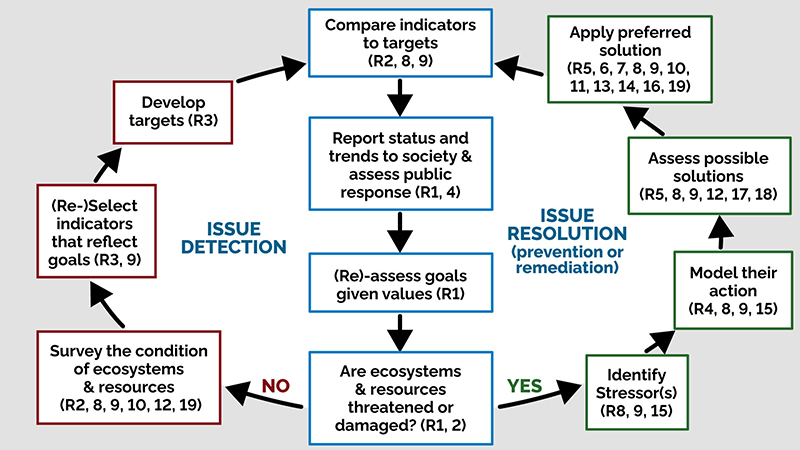
We look forward to the opportunity to work with the MECP to make the recommendations we have detailed a reality, in the next phase of development of the Muskoka Watershed Initiative starting with:
- Providing assistance in the identifying municipal, federal and private funding opportunities for the MWI and
- Participating in public, community and indigenous engagement efforts upon request from the Minister
Appendix A – Glossary
- Ca
- Calcium
- CI
- Chloride
- CRT
- Community Round Table
- DESC
- Dorset Environmental Science Centre
- DMM
- District of Muskoka
- FOCA
- Federation of Ontario Cottagers Associations
- GIS
- Geographic Information Systems
- HABs
- Hazardous Algal Blooms
- IWM
- Integrated Watershed Management
- LOBA
- Lake of Bays Association
- MECP
- Ministry of the Environment, Conservation and Parks
- MOI
- Ministry of Infrastructure
- MLA
- Muskoka Lakes Association
- MMAH
- Ministry of Municipal Affairs and Housing
- MNRF
- Ministry of Natural Resources and Forests
- MRWMP
- Muskoka River Water Management Plan
- MTO
- Ministry of Transportation
- MWC
- Muskoka Watershed Council
- MWI
- Muskoka Watershed Initiative
- NaCI
- Sodium Chloride
- N
- Nitrogen
- NGO
- Non-Government Organization
- NOZ
- Normal Operating Zone
- OBC
- Ontario Biodiversity Council
- OPG
- Ontario Power Generation
- OMAFRA
- Ontario Ministry of Agriculture, Food and Rural Affairs
- P
- Phosphorus
- PPS
- Provincial Policy Statement
- SARO
- Species at Risk in Ontario
- SREL
- Swift River Energy Limited
- TML
- Township of Muskoka Lakes
Appendix B - Summary of community outreach
Type of organization
Local government
- District of Muskoka Council
- Town of Bracebridge
- Town of Gravenhurst
- Town of Huntsville
- Township of Georgian Bay
- Township of Lake of Bays
- Township of Muskoka Lakes
- Township of Algonquin Highlands
- TML OP Review Committee
Provincial government
- Ontario Special Flood Advisor on Flooding
First Nations
- Shawanaga First Nation
- Wahta Mohawk First Nation
- Wasauksing First Nation
Metis Nations of Ontario
- Georgian Bay Traditional Territory Consultation Committee
Lake associations
- Bass Lake Association
- Brandy Lake Association
- Kawartha Lake Action Plan
- Lake of Bays Lake Association
- Leonard Lake Association
- Mary Lake Association
- Michael Hart/MLA
- Muskoka Lakes Association
Community/Stewardship
- Andrew Daniels Fish Stewardship Foundation
- Couchiching Conservancy
- Federation of Ontario Cottagers Association
- Friends of Muskoka
- Friends of the Muskoka Watershed
- Georgian Bay Biosphere Reserve
- Muskoka Community Foundation
- Muskoka Conservancy
- Muskoka Federation of Agriculture
- Muskoka Freshwater Foundation
- Muskoka Ratepayers Association
- Muskoka Watershed Council
Economic development
- Algonquin Outfitters
- Muskoka Lakes Chamber of Commerce
- Muskoka Tourism
- Explorers Edge
- J.W.Marriott, The Rosseau Resort & Spa
Planning, consulting and construction
- Bob List Planning
- French Planning
- Greenland Team
- Hutchinson Environmental
- Michalski Nielsen Associates
- Muskoka Builders Association
- Planscape
- Riverstone Environmental
Waterpower producers
- Bracebridge Generation
- Ontario Power Generation
- Ontario Waterpower Association
- Orillia Power
- Swift River Energy Limited
Agriculture sector
- Ontario Federation of Agriculture (have local/regional federations)
- Ontario Ministry of Agriculture Food and Rural Affairs
- Ontario Soil and Crop Improvement Association (have local/regional associations)
Education
- Georgian College
Appendix C - Summary of community outreach input
Summary of percentage of times a particular environmental concern or issue was raised in collective (Aggregate, n = 162 issues) or individual (n = 39 issues) responses from the Muskoka public (see Appendix B for the list of collective responders). Concerns are sorted by the number of times they were raised in the collective responses. Only concerns raised more than once are tabulated. The issues raised only once are included in the footnote, and are the reason that the sum of the values is less than 100%
| Environmental concern | Aggregate | Individual |
|---|---|---|
| Flood management | 12 | 31 |
| Inadequate public communication | 10 | N/A |
| Outdated watershed hydrology model | 9 | 5 |
| Inadequate watershed governance | 8 | N/A |
| Inadequate diagnostic or strategic research or issues | 7 | N/A |
| Climate change | 7 | 5 |
| Inadequate assessment or monitoring | 7 | N/A |
| Pressures from over-development | 7 | 8 |
| Loss of natural assets | 6 | 13 |
| Inadequate attention to economic, social, ecological balance | 4 | N/A |
| Hazardous Algal Blooms (HABs) | 4 | 8 |
| Inadequate tools to management development | 4 | N/A |
| Flooding and erosion | 2 | N/A |
| Road salt | 2 | N/A |
| Invading species | 2 | N/A |
| Impacts of calcium decline | 2 | N/A |
| Provincial models poor fit to Muskoka | 1 | N/A |
| Ice bubblers | 1 | N/A |
Footnotes
- footnote[1] Back to paragraph Sale P., Trimble K., Lammers R, Doyle C., Ross G., Yan N. & P. Arney. (2020). The Case for Integrated Watershed Management in Muskoka. A Report from the Muskoka Watershed Council, Muskoka Watershed Council, p. 10
- footnote[2] Back to paragraph Sale et al., (2020). The Case for Integrated Watershed Management. A Report from the Muskoka Watershed Council. Muskoka Watershed Council, p. 17
- footnote[3] Back to paragraph National Geographic, 2011
- footnote[4] Back to paragraph Planning for Climate Change in Muskoka, 2016, Muskoka Watershed Council, p. 5
- footnote[5] Back to paragraph Vital Signs Report, 2018, Muskoka Community Foundation, p. 4
- footnote[6] Back to paragraph Tatley,R. (1983). The Steamboat Era in the Muskokas, Vol 1, To The Golden Years, Boston Mills Press, p. 304
- footnote[7] Back to paragraph Lundell, L. (2003). Old Muskoka, Country Cottages & Summer Estates, Boston Mills Press, p. 176
- footnote[8] Back to paragraph Second Home Study, 2017, District of Muskoka
- footnote[9] Back to paragraph Vital Signs Report, 2018, Muskoka Community Foundation
- footnote[10] Back to paragraph District of Muskoka Economic Profile, 2011
- footnote[11] Back to paragraph National Geographic, 2011 and National Geographic 2012
- footnote[12] Back to paragraph McNeil, D. An Independent Review of the 2019 Flood Events in Ontario, 2019, p. 156
- footnote[13] Back to paragraph Protecting People and Property: Ontario's Flooding Strategy, 2020, p. 41
- footnote[14] Back to paragraph Hatch Engineering Report, February 12, 2020. Technical Report for Muskoka River Flood Plain Mapping Study, The District Municipality of Muskoka, H356689-00000-200-230-0002, Rev.0, Ver. 04.03, 131pp.
- footnote[15] Back to paragraph MLA briefing notes for MNRF June 2016.
- footnote[16] Back to paragraph McNeil, D. An Independent Review of the 2019 Flood Events in Ontario, 2019, p. 104
- footnote[17] Back to paragraph Reid, A. J. et al. (2019). Emerging threats and persistent conservation challenges for freshwater biodiversity. Biol. Rev. 94, pp. 849-873.
- footnote[18] Back to paragraph Hughes, S.R., P. Kay and L.E. Brown. (2013). Global synthesis and critical evaluation of pharmaceutical data sets collected from river systems. Env. Sci. Technol. 47, pp. 661-677
- footnote[19] Back to paragraph Favot E.J. et al. (2019). Climate variability promotes unprecedented cyanobacterial blooms in a remote, oligotrophic Ontario lake: evidence from paleolimnology. J. Paleolim. Doi.org/10.1007/s10933-019-0074-4
- footnote[20] Back to paragraph State of Ontario's Biodiverity 2015, Ontario Biodiversity Council
- footnote[21] Back to paragraph State of Ontario's Biodiversity 2015, Ontario Biodiversity Council
- footnote[22] Back to paragraph Environment Canada, 2010
- footnote[23] Back to paragraph Environment Canada/Beacon Environmental 2012
- footnote[24] Back to paragraph Environment Canada 2013
- footnote[25] Back to paragraph Veale, B. & Cooke, S. (2017). Implementing integrated water management: illustrations from the Grand River watershed. International Journal of Water Resources Development, 33(3), pp. 375-392.
- footnote[26] Back to paragraph Sale et al., (2020). The Case for Integrated Watershed Management. A Report from the Muskoka Watershed Council. Muskoka Watershed Council, p. 10
- footnote[27] Back to paragraph .Sale et al., (2020). The Case for Integrated Watershed Management. A Report from the Muskoka Watershed Council. Muskoka Watershed Council, p. 17.
- footnote[28] Back to paragraph Veale, B. & Cooke, S. (2017). Implementing integrated water management: illustrations from the Grand River watershed. International Journal of Water Resources Development, 33(3), pp. 375-392.
- footnote[29] Back to paragraph Calder, (2006). Forest and Floods: Moving to an Evidence-based Approach to watershed and Integrated Flood Management, p. 1.
- footnote[30] Back to paragraph Protecting People and Property: Ontario’s Flooding Strategy, 2020, p. 11.
- footnote[31] Back to paragraph Hooper (2006). Key Performance Indicators of River Basin Organizations, 2006-VSP-01. Institute of Water Resources, US Army Corps of Engineers, 86 pp.
- footnote[32] Back to paragraph Ontario’s Flooding Strategy: Protecting People and Property, 2020.
- footnote[33] Back to paragraph Ontario’s Flooding Strategy: Protecting People and Property, 2020, p. 10-11.
- footnote[34] Back to paragraph Ontario’s Flooding Strategy: Protecting People and Property, 2020, p. 38.
- footnote[35] Back to paragraph Ontario’s Flood Strategy: Protecting People and Property, 2020, p. 24
- footnote[36] Back to paragraph Ontario’ Flood Strategy: Protecting People and Property, 2020, p. 16
- footnote[37] Back to paragraph Ontario Ministry of Natural Resources and Forestry, 2020, “Protecting People and Property: Ontario’s Flooding Strategy”, 42pp.
- footnote[38] Back to paragraph Canadian Ministry of Environment and Climate Change, 2019, “Canada’s Changing Climate Report, 85pp.
- footnote[39] Back to paragraph Sale, Peter et al, 2020, The Case for Integrated Watershed Management in Muskoka, Muskoka Watershed Council, Muskoka, Canada, 25pp.
- footnote[40] Back to paragraph Sale, Peter et al, 2020, The Case for Integrated Watershed Management in Muskoka, Muskoka Watershed Council, Muskoka, Canada, 25pp.
- footnote[41] Back to paragraph McNeil,D. An Independent Review of the 2019 Flood Events in Ontario, 2019, p. 8.
- footnote[42] Back to paragraph Canadian Ministry of Environment and Climate Change, 2019, “Canada’s Changing Climate Report, 85pp.
- footnote[43] Back to paragraph Sale, Peter et al, January 2016, Planning for Climate Change in Muskoka, Muskoka Watershed Council, Muskoka, Canada, 52pp. Hackner Holden Agreement
- footnote[44] Back to paragraph Hackner Holden Agreement, 1940. Muskoka River – Notes of Conferences and Agreements Re Lake Levels and River Flow.
- footnote[45] Back to paragraph McNeil, D. An Independent Review of the 2019 Flood Events in Ontario, 2019.
- footnote[46] Back to paragraph Hatch Engineering Report, February 12, 2020. Technical Report for Muskoka River Flood Plain Mapping Study, The District Municipality of Muskoka, H356689-00000-200-230-0002, Rev.0, Ver. 04.03,
- footnote[47] Back to paragraph Concerns or issues raised once only included aging population, housing, inadequate research infrastructure, inadequate funding, inadequate public access to water, increasing pressure from transient lake users (eg. AirB&B), too little interaction with first nations, air pollution, lack of staff training, lack of transit, and bacterial pollution of water.