Algonquin land claim – additions to Ontario’s provincial park and conservation reserve system
Read about proposals related to provincial park and conservation reserve boundary amendments within the Algonquin Land Claim Settlement Area.
Background
Since 1991, the governments of Canada, Ontario and the Algonquins of Ontario (AOO) (known as the negotiation parties) have been negotiating towards a settlement of the Algonquin land claim. If successful, the negotiations will produce the province’s first modern-day constitutionally protected treaty.
These treaty negotiations include recommendations to:
- add Crown land to Lake St. Peter Provincial Park (Recreational Class)
- create Whiteduck Provincial Park (Natural Environment Class), the recommended provincial park in the area of the Crotch Lake Conservation Reserve
Consultation with the public, stakeholders and Indigenous communities was initiated in fall 2020 on the proposal to:
- amend the boundary of Lake St. Peter Provincial Park
- establish a boundary for Whiteduck Provincial Park
As a result of stakeholder feedback on the recommended boundary for Whiteduck Provincial Park, the negotiation parties agreed to consider adding certain Crown lands to the adjacent Hungry Lake Conservation Reserve instead. These Crown lands were originally proposed as part of the recommended Whiteduck Provincial Park.
The addition of these lands to Hungry Lake Conservation Reserve was not considered in the Algonquins of Ontario Agreement in Principle (2016). At the same time, unopened road allowances currently not included in the existing Hungry Lake Conservation Reserve boundary are also being considered for addition to the conservation reserve.
This resulted in an alternate proposal to add Crown land to Hungry Lake Conservation Reserve.
About the consultation
This consultation supports Canada, Ontario and the AOOs ongoing negotiations towards a modern treaty to resolve the Algonquin land claim in eastern Ontario.
In order to amend, rescind or establish boundaries by regulation under the Provincial Parks and Conservation Reserves Act, 2006 (PPCRA) we must assess the potential environmental effects associated with the projects and consult with the public, Indigenous communities and stakeholders who have an interest in, or may be affected by the projects, as provided for in the Algonquin Land Claim Declaration Order, under the Environmental Assessment Act (EAA).
These proposed additions to the provincial parks and conservation reserve system will take effect following the successful negotiation of a final agreement to resolve the Algonquin land claim.
2022 consultations
From December 8, 2022 to January 23, 2023, as part of the ongoing consultations, we will engage with the public, stakeholders and Indigenous communities on the proposal to amend the boundary of Hungry Lake Conservation Reserve.
No amendments are being contemplated to the Fish and Wildlife Conservation Act, 1997 (FWCA) as a result of this proposal.
Hunting will continue to be permitted on these Crown lands proposed for addition to the conservation reserve consistent with the rules and regulations for Wildlife Management Unit 62.
2022 Boundary amendment project notice
Public Notice for Category B Project Evaluation - Amending a Boundary by Regulation to add Crown Land to Hungry Lake Conservation Reserve
The proposal would add Crown land to Hungry Lake Conservation Reserve in Frontenac County. These lands were previously identified for inclusion within the recommended Whiteduck Provincial Park. Consultation under the Algonquins of Ontario Land Claim Declaration Order process and subsequent negotiations has resulted in this alternate proposal. The Ontario Ministry of the Environment, Conservation and Parks (MECP) invites comment from the public, Indigenous communities and agencies with an interest in this proposal.
This addition to Hungry Lake Conservation Reserve project evaluation is associated with, but separate from, a consultation process that was initiated in 2020 related to the creation of Whiteduck Provincial Park. As a result of public feedback, the subject lands are now being assessed as an addition to Hungry Lake Conservation Reserve.
This project is being evaluated as a Category B project under the Algonquin Land Claim Declaration Order made under the Environmental Assessment Act. The project area has ecological, historical, cultural and spiritual importance to the Algonquins of Ontario.
Recommendations for additions to Ontario’s provincial park and conservation reserve system were set out in the 2016 Algonquins of Ontario Agreement-in-Principle, in order to recognize their importance while providing for continued use and enjoyment by the public for present and future generations.
The proposed additions to Hungry Lake Conservation Reserve will depend on the successful negotiation of a final agreement to resolve the Algonquin Land Claim.
A Notice of Completion will be sent to those who submit comments or request further notice when the project evaluation is finished. MECP may proceed with the regulation process without issuing a further general notice.
How to participate
Comments on this proposal will be accepted for a 45 day comment period, ending on January 23, 2023.
To submit comments or to request the Notice of Completion, please contact:
Ontario Information Centre, Algonquin Land Claim
Algonquin Land Claim
31 Riverside Drive
Pembroke, Ontario
K8A 8R6
eerfeedback@ontario.ca
2022 Maps
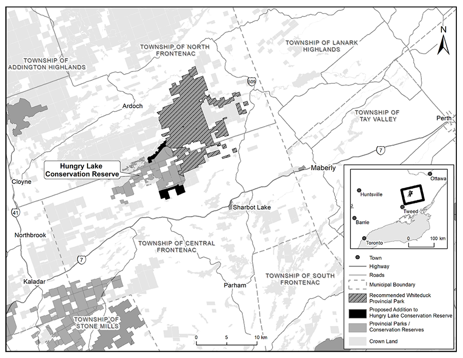
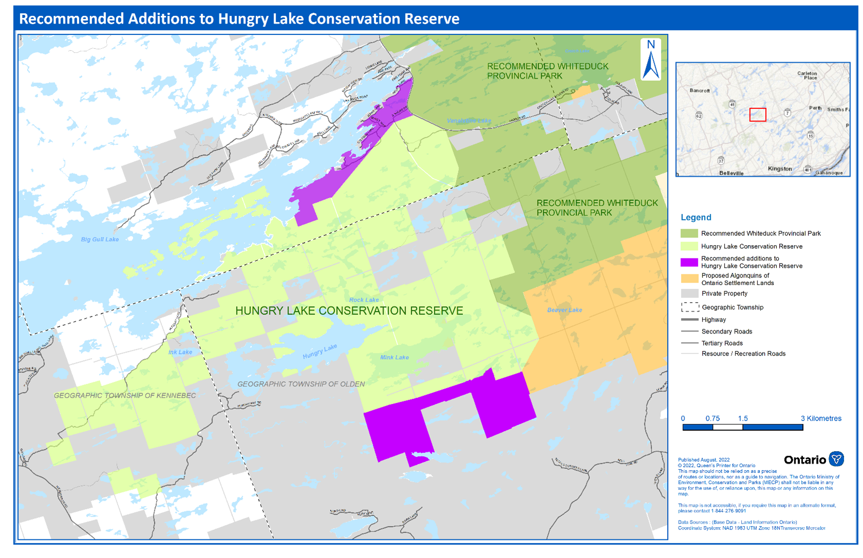
Map – Recommended Additions to Hungry Lake Conservation Reserve

This map shows the recommended additions to Hungry Lake Conservation Reserve. The reserve is located in Frontenac County, approximately 15 kilometres northwest of the town of Sharbot Lake and 45 kilometres west of the town of Perth. Map features include the boundary for the existing Hungry Lake Conservation Reserve, the proposed addition to the Hungry Lake Conservation Reserve boundary and the western part of the boundary for the recommended Whiteduck Provincial Park.
2020 Consultations
From October 26 to January 25, 2021 as part of the ongoing consultations related to the treaty negotiations with the AOO, we engaged with the public, stakeholders and Indigenous communities on the proposal to:
- amend the boundary of Lake St. Peter Provincial Park
- establish Whiteduck Provincial Park
We also consulted on sport hunting for these two recommended provincial park boundaries. Under the PPCRA, hunting is not permitted in a provincial park unless it is allowed by regulation made under the Fish and Wildlife Conservation Act, 1997 (FWCA).
We proposed amendments to the FWCA to allow sport hunting to continue in these two provincial parks after their boundaries are amended or established by regulation.
2020 Boundary amendment project notice
Consultation on the following proposal closed on January 25, 2021. New comments are no longer being considered.
The Algonquins of Ontario Land Claim negotiation process has resulted in recommendations to expand Lake St. Peter Provincial Park and create a new provincial park in Frontenac County.
The Ontario Ministry of the Environment, Conservation and Parks (MECP) invites comment from the public, Indigenous communities and agencies with a known or potential interest on the following two projects:
- Amending a boundary by regulation to add Crown land to Lake St. Peter Provincial Park (Recreational Class).
- Rescinding a boundary by regulation for Crotch Lake Conservation Reserve (the lands to be included in Whiteduck Provincial Park) and establishing a boundary by regulation to create Whiteduck Provincial Park (Natural Environment Class).
These two projects are being evaluated as Category B projects under the Algonquin Land Claim Declaration Order made under the EAA. The project areas have historical, cultural and spiritual importance to the AOO.
The recommendation for these additions to Ontario’s protected areas was set out in the 2016 Algonquins of Ontario Agreement-in-Principle (PDF) (AIP), in order to recognize their importance while providing for continued use and enjoyment by the public for present and future generations.
A Notice of Completion will be sent to those who submit comments or request further notice when the project evaluation is finished. MECP may proceed with the regulation process without issuing a further general notice.
These proposed additions to the provincial park system will depend on the successful negotiation of a Final Agreement to resolve the Algonquin Land Claim.
This map shows the recommended addition to Lake St. Peter Provincial Park
This map shows the recommended boundary for Whiteduck Provincial Park
How to participate
Comments will be accepted until January 25, 2021. To submit comments or to request the Notice of Completion, contact:
Ontario Information Centre, Algonquin Land Claim
Algonquin Land Claim
31 Riverside Drive
Pembroke, Ontario
K8A 8R6
eerfeedback@ontario.ca
We prepared a Draft Environmental Assessment Summary Report to communicate the details of these project assessments. The report identifies and evaluates all known environmental effects using the following considerations:
- natural environment
- land use and resource management
- social, cultural and economic
2020 Maps
View the maps of the recommended provincial park additions.
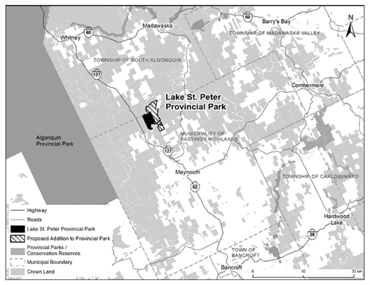
Map 1 – Recommended addition to Lake St. Peter Provincial Park
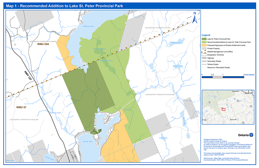
This map shows the recommended addition to Lake St. Peter Provincial Park, located in the northern part of the Municipality of Hastings Highlands and southern part of the Township of South Algonquin, approximately 30 kilometres north of the town of Bancroft and 25 kilometres south of the town of Whitney. The recommended addition borders the southeast shoreline of McKenzie Lake and is located east and southeast of the current park boundary for Lake St. Peter Provincial Park. Map features include the boundaries for Wildlife Management Units 55A and 57.
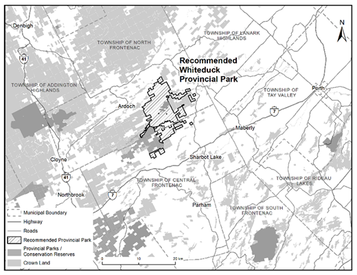
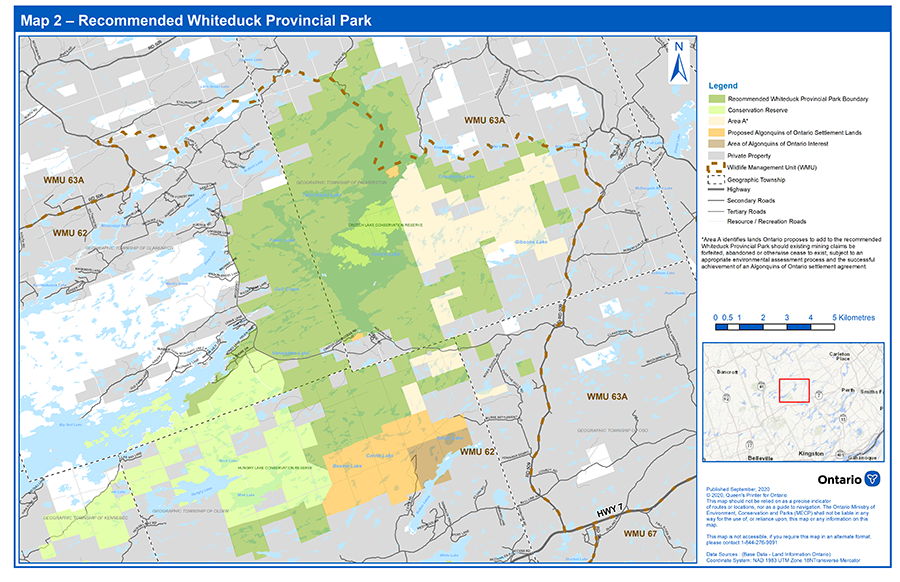
Map 2 – Recommended Whiteduck Provincial Park boundary
This map shows the recommended boundary for Whiteduck Provincial Park, located in Frontenac County, approximately 15 kilometres northwest of the town of Sharbot Lake and 45 kilometres west of the town of Perth. Map features include the boundaries for the existing Crotch Lake Conservation Reserve and Wildlife Management Units 62 and 63A. Area A describes land subject to existing mining claims that are not included in the described recommended boundary.
2020 Proposal to amend regulations under the Fish and Wildlife Conservation Act (FWCA)
Consultation on the following proposal closed on January 25, 2021. New comments are no longer being considered.
A concurrent consultation process seeking your input is also underway related to proposed changes to hunting regulations under the FWCA for these two recommended provincial park boundaries.
These proposed changes would allow hunting to continue as described in the associated proposal.
Proposal summary
We are proposing changes to hunting regulations related to:
- the recommended addition to Lake St. Peter Provincial Park
- the recommended Whiteduck Provincial Park (i.e., a new Provincial Park near the area of Crotch Lake Conservation Reserve
Background
Canada, Ontario and the AOO are working together to resolve a land claim through a negotiated Final Agreement that will take the form of a modern-day treaty. All three parties are committed to finding a balanced and shared solution that respects the rights of all Canadians.
The Agreement in Principle (AIP) was signed by the three negotiation parties in 2016, setting out elements of the proposed settlement including a provision that states that the Final Agreement will describe the boundaries for a recommended addition to Lake St. Peter Provincial Park and a recommended Provincial Park (Natural Environment Class) in the area of the Crotch Lake Conservation Reserve (AIP, Section 9.1.30).
These proposed additions to the provincial park system will depend on the successful negotiation of a Final Agreement to resolve the Algonquin Land Claim.
Presently, hunting on Crown lands negotiated for the recommended addition to Lake St. Peter Provincial Park and the recommended Whiteduck Provincial Park (i.e., where there is no regulated provincial park boundary) follow the general hunting rules associated with the wildlife management unit (WMU) the land falls within.
Under the PPCRA, hunting is not permitted in a provincial park unless it is allowed by regulation made under the FWCA. Similarly, under the FWCA, hunting is not allowed in a provincial park except in the circumstances prescribed in the regulations. In provincial parks where hunting is allowed, the allowable species (for example, game mammal, game bird, furbearing mammal, etc.) and their open seasons are typically more restrictive than what is provided for in the parts of the WMU outside of provincial parks.
Proposal details
Consistent with the policies of the Ontario's Living Legacy Land Use Strategy (1999), we are proposing to implement FWCA regulation changes as follows:
- within the recommended addition to Lake St. Peter Provincial Park hunting would be allowed consistent with the provisions outlined under section 110.1, Part XIV (Hunting in Provincial Parks and on Designated Crown Land)
- within the recommended Whiteduck Provincial Park, hunting would be allowed consistent with the provisions outlined under section 110.1, Part XIV (Hunting in Provincial Parks and on Designated Crown Land)
No change is proposed to the hunting rules as they apply to the lands associated with the existing boundary of Lake St. Peter Provincial Park (i.e., section 110 Part XIV (Hunting in Provincial Parks and on Designated Crown Land).
Should this proposal go ahead, the hunting rules within Lake St. Peter Provincial Park will be different depending on whether hunting is occurring on lands associated with the recommended addition or on lands associated with the existing regulated provincial park.
We intend to amend Ontario Regulation 665/98 (Hunting) and Ontario Regulation 663/98 (Area Descriptions) under the FWCA, concurrent with regulation changes to Ontario Regulation 316/07 (Designation and Classification of Provincial Parks) under the PPCRA.
No other opportunity for comments will be provided.
Consultation opportunity
Submit your comments on this proposal to:
Ontario Information Centre
Algonquin Land Claim
31 Riverside Drive
Pembroke, Ontario
K8A 8R6
eerfeedback@ontario.ca
Comments must be received within the 45-day comment period, which expires on January 25, 2021.