Amendments to the Growth Plan for the Greater Golden Horseshoe
Learn about changes made to the 2006 land use plan for the Greater Golden Horseshoe region.
Amendment 1 (2012) to the Growth Plan for the Greater Golden Horseshoe, 2006
6.0 Simcoe Sub-area
Definitions
Schedule 7: Distribution
Schedule 8: Simcoe Sub-area
6.0 Simcoe Sub-area
6.1 Context
The Simcoe Sub-area is comprised of the County of Simcoe and the cities of Barrie and Orillia. Section 6 provides more detailed direction on how this Plan’s vision will be achieved in the Simcoe Sub-area.
The policies in Section 6 direct a significant portion of growth within the Simcoe Sub-area to communities where development can be most effectively serviced, and where growth improves the range of opportunities for people to live, work, and play in their communities, with a particular emphasis on primary settlement areas. The City of Barrie is the principal primary settlement area. Downtown Barrie is the only urban growth centre in the Simcoe Sub-area. The policies in Section 6 recognize and support the vitality of urban and rural communities in the Simcoe Sub-area. All municipalities will play an important role in ensuring that future growth is planned for and managed in an effective and sustainable manner that conforms with this Plan. The intent of this policy is that by 2031 development for all the municipalities within Simcoe County will not exceed the overall population and employment forecasts contained in Schedule 7.
Ensuring an appropriate supply of land for employment and residential growth, and making the best use of existing infrastructure is also important to the prosperity of the Simcoe Sub-area. Section 6 identifies specific employment areas that will enable municipalities in the Simcoe Sub-area to benefit from existing and future economic opportunities. By providing further direction on where growth is to occur in the Simcoe Sub-area, it also establishes a foundation for municipalities to align infrastructure investments with growth management, optimize the use of existing, planned and new infrastructure, co-ordinate water and wastewater services, and promote green infrastructure and innovative technologies.
A more livable, compact, complete urban structure with good design and built form will support the achievement of economic and environmental benefits. Through effective growth management, municipalities will ensure that the natural environment is protected from the impacts of growth in the Simcoe Sub-area, while providing amenities for the residents and visitors to this area from across the Greater Golden Horseshoe and beyond.
6.2 Growth Forecasts
- Notwithstanding policy 5.4.2.2(a), lower-tier municipalities in the County shall use the population and employment forecasts contained in Schedule 7 for planning and managing growth in the Simcoe Sub-area. In the application of the policies of this Plan, in the Simcoe Sub-area Schedule 7 will be applied instead of Schedule 3.
- The employment forecasts in Schedule 7 include employment located in the strategic settlement employment areas and economic employment districts.
- The Minister of Infrastructure will review the forecasts contained in Schedule 7 in conjunction with the review of Schedule 3, and in consultation with municipalities in the Simcoe Sub-area, and may revise the forecasts.
6.3 Managing Growth
6.3.1 Primary Settlement Areas
- Primary settlement areas for the Simcoe Sub-area are identified in Schedule 8.
- Municipalities with primary settlement areas will, in their official plans and other supporting documents:
- identify primary settlement areas
- identify and plan for intensification areas within primary settlement areas
- plan to create complete communities within primary settlement areas
- ensure the development of high quality urban form and public open spaces within primary settlement areas through site design and urban design standards that create attractive and vibrant places that support walking and cycling for everyday activities and are transit-supportive.
- Primary settlement areas in the County will be identified in the official plan of the County of Simcoe.
- The Town of Innisfil, Town of Bradford West Gwillimbury and the Town of New Tecumseth will direct a significant portion of population and employment growth forecasted in Schedule 7 to the applicable primary settlement areas. The Town of Bradford West Gwillimbury and the Town of Innisfil, in planning to meet their employment forecasts, may direct appropriate employment to the Bradford West Gwillimbury strategic settlement employment area and the Innisfil Heights strategic settlement employment area respectively.
6.3.2 Settlement Areas
- Development may be approved in settlement areas in excess of what is needed to accommodate the forecasts in Schedule 7, provided the development:
- contributes to the achievement of the intensification targets and density targets identified by the Minister in accordance with policy 6.5.3
- is on lands for urban uses as of January 19, 2012
- can be serviced in accordance with applicable provincial plans and provincial policies.
- in accordance with the requirements of the Lake Simcoe Protection Plan, 2009, if applicable.
- The County may approve adopted official plans or adopted official plan amendments regarding lands within a settlement area that redesignate lands not for urban uses to land for urban uses that are in excess of what is needed for a time horizon of up to 20 years or to accommodate the forecasts in Schedule 7, whichever is sooner, provided it is demonstrated that this growth:
- can be serviced in accordance with applicable provincial plans and provincial policies
- contributes to the achievement of the intensification target and density target set in accordance with policy 6.5.3
- contributes to the development of a complete community
- is subject to phasing policies
- contributes to the achievement of the jobs to residents ratio in Schedule 7 for the lower-tier municipality
- is in accordance with the requirements of the Lake Simcoe Protection Plan, 2009, if applicable
- is supported by appropriate transportation infrastructure and is in accordance with any transportation guidelines and policies developed by the County of Simcoe
- is in accordance with any additional growth management policies specified by the County of Simcoe that do not conflict with the policies in this Plan.
- The sum of all population growth accommodated on lands for urban uses approved pursuant to policy 6.3.2.2 shall not exceed a total population of 20,000 for the County of Simcoe.
- Municipalities in the County of Simcoe may approve development on lands for urban uses approved pursuant to policies 6.3.2.2 and 6.3.2.3.
- Policies 6.3.2.2 and 6.3.2.3 will apply to the County of Simcoe and its lower-tier municipalities until January 19, 2017.
- The County of Simcoe Council will monitor and report annually on approvals made pursuant to policies 6.3.2.2 and 6.3.2.3.
- Settlement area boundary expansions are subject to policy 2.2.8 of this Plan, except policies 2.2.8.2(a)(i) and 2.2.8.2(i).
- In addition to policy 4.2.4 of this Plan, municipalities in the Simcoe-Sub-area are encouraged to achieve greater efficiency and conservation in energy, water and wastewater management through building and community design.
- The County of Simcoe and the lower-tier municipalities in the County shall establish and implement phasing policies to ensure the orderly and timely progression of development on lands for urban uses.
- The County of Simcoe will develop and implement through its official plan, policies to implement policy 6.3.2.
6.4 Employment Lands
- The Bradford West Gwillimbury strategic settlement employment area, the Innisfil Heights strategic settlement employment area, the Lake Simcoe Regional Airport economic employment district and the Rama Road economic employment district are identified in Schedule 8.
- The Minister of Infrastructure, in consultation with other Ministers of the Crown, and affected municipalities and stakeholders, will determine the location and boundaries of strategic settlement employment areas, and may establish as appropriate the following:
- Permitted uses, and the mix and percentage of certain uses;
- Permitted uses for specific areas within the strategic settlement employment areas;
- Lot sizes; and
- Any additional policies and definitions that apply to these areas.
- The Minister of Infrastructure, in consultation with other Ministers of the Crown, and affected municipalities and stakeholders, will determine the location and boundaries, and establish as appropriate the uses permitted in the economic employment districts.
- The Minister of Infrastructure may review and amend decisions made pursuant to policies 6.4.2 and 6.4.3. Municipalities in the Simcoe Sub-area may request the Minister to consider a review.
- The County of Simcoe and lower-tier municipalities in the County in which the strategic settlement employment areas and economic employment districts are located, will delineate the areas and districts as determined by the Minister of Infrastructure, in their official plans.
- The lower-tier municipalities in the County in which the strategic settlement employment areas and economic employment districts are located will develop official plan policies to implement the matters determined by the Minister of Infrastructure in accordance with policies 6.4.2, 6.4.3, and 6.4.4, as applicable.
- Although not settlement areas, the strategic settlement employment areas and economic employment districts are considered designated greenfield area for the purposes of policies 2.2.7.2, 2.2.7.3, and 2.2.7.5 of this Plan.
- For lands within strategic settlement employment areas and the economic employment districts the municipality can identify the natural heritage systems, features, and areas for protection.
6.5 Implementation
- The policies in Section 6 apply only to the Simcoe Sub-area.
- For the Simcoe Sub-area, where there is a conflict between policies in Section 6, Schedule 7, and Schedule 8 and the remainder of this Plan, the policies in Section 6, Schedule 7, and Schedule 8 prevail.
- Notwithstanding policies 5.4.2.2(b) and 5.4.2.2(c), the Minister of Infrastructure will identify for the County of Simcoe and the lower-tier municipalities in the County intensification targets to achieve the intensification target, and identify density targets to achieve the density target for designated greenfield areas.
Definitions
- Bradford West Gwillimbury strategic settlement employment area:
- Location set out in Schedule 8. The Bradford West Gwillimbury strategic settlement employment area boundary is determined by the Minister of Infrastructure and planned for in accordance with policy 6.4.
- Economic employment districts:
- To be planned and protected for locally significant employment uses. These are not settlement areas.
- Innisfil Heights strategic settlement employment area:
- Location set out in Schedule 8. The Innisfil Heights strategic settlement employment area boundary is determined by the Minister of Infrastructure and planned for in accordance with policy 6.4.
- Lake Simcoe Regional Airport economic employment district:
- Location set out in Schedule 8. The Lake Simcoe Regional Airport economic employment district boundary is determined by the Minister of Infrastructure and planned for in accordance with policy 6.4. Major retail and residential uses are not permitted.
- Lands for urban uses:
- Lands that are not designated for agricultural or rural uses within a settlement area identified in the approved official plan for the municipality.
- Lands not for urban uses:
- Lands that are designated for agricultural or rural uses within a settlement area identified in the approved official plan for the municipality.
- Municipalities with primary settlement areas:
- City of Barrie, City of Orillia, Town of Bradford West Gwillimbury, Town of Collingwood, Town of Innisfil, Town of Midland, Town of New Tecumseth, and Town of Penetanguishene.
- Primary settlement areas:
- Locations set out in Schedule 8. Primary settlement areas are the settlement areas of the City of Barrie, the City of Orillia, the Town of Collingwood, the Town of Midland together with the Town of Penetanguishene, and the settlement areas of the communities of Alcona in the Town of Innisfil, Alliston in the Town of New Tecumseth and Bradford in the Town of Bradford West Gwillimbury.
- Rama Road economic employment district:
- Location set out in Schedule 8. The Rama Road economic employment district boundary is determined by the Minister of Infrastructure and planned for in accordance with policy 6.4. Major retail uses are not permitted.
- Simcoe Sub-area:
- The geographic area consisting of the County of Simcoe, the City of Barrie and the City of Orillia.
- Strategic settlement employment areas:
- To be planned and protected for employment uses that require large lots of land and depend upon efficient movement of goods and access to Highway 400. These are not settlement areas. Major retail and residential uses are not permitted.
Schedule 7
| Region | Population | Employment |
|---|---|---|
| City of Barrie | 210,000 | 101,000 |
| City of Orillia | 41,000 | 21,000 |
| Township of Adjala-Tosorontio | 13,000 | 1,800 |
| Town of Bradford West Gwillimbury | 50,500 | 18,000 |
| Township of Clearview | 19,700 | 5,100 |
| Town of Collingwood | 33,400 | 13,500 |
| Township of Essa | 21,500 | 9,000 |
| Town of Innisfil | 56,000 | 13,100 |
| Town of Midland | 22,500 | 13,800 |
| Town of New Tecumseth | 56,000 | 26,500 |
| Township of Oro-Medonte | 27,000 | 6,000 |
| Town of Penetanguishene | 11,000 | 6,000 |
| Township of Ramara | 13,000 | 2,200 |
| Township of Severn | 17,000 | 4,400 |
| Township of Springwater | 24,000 | 5,600 |
| Township of Tay | 11,400 | 1,800 |
| Township of Tiny | 12,500 | 1,700 |
| Town of Wasaga Beach | 27,500 | 3,500 |
| Total Simcoe sub-area | 667,000 | 254,000 |
Schedule 8
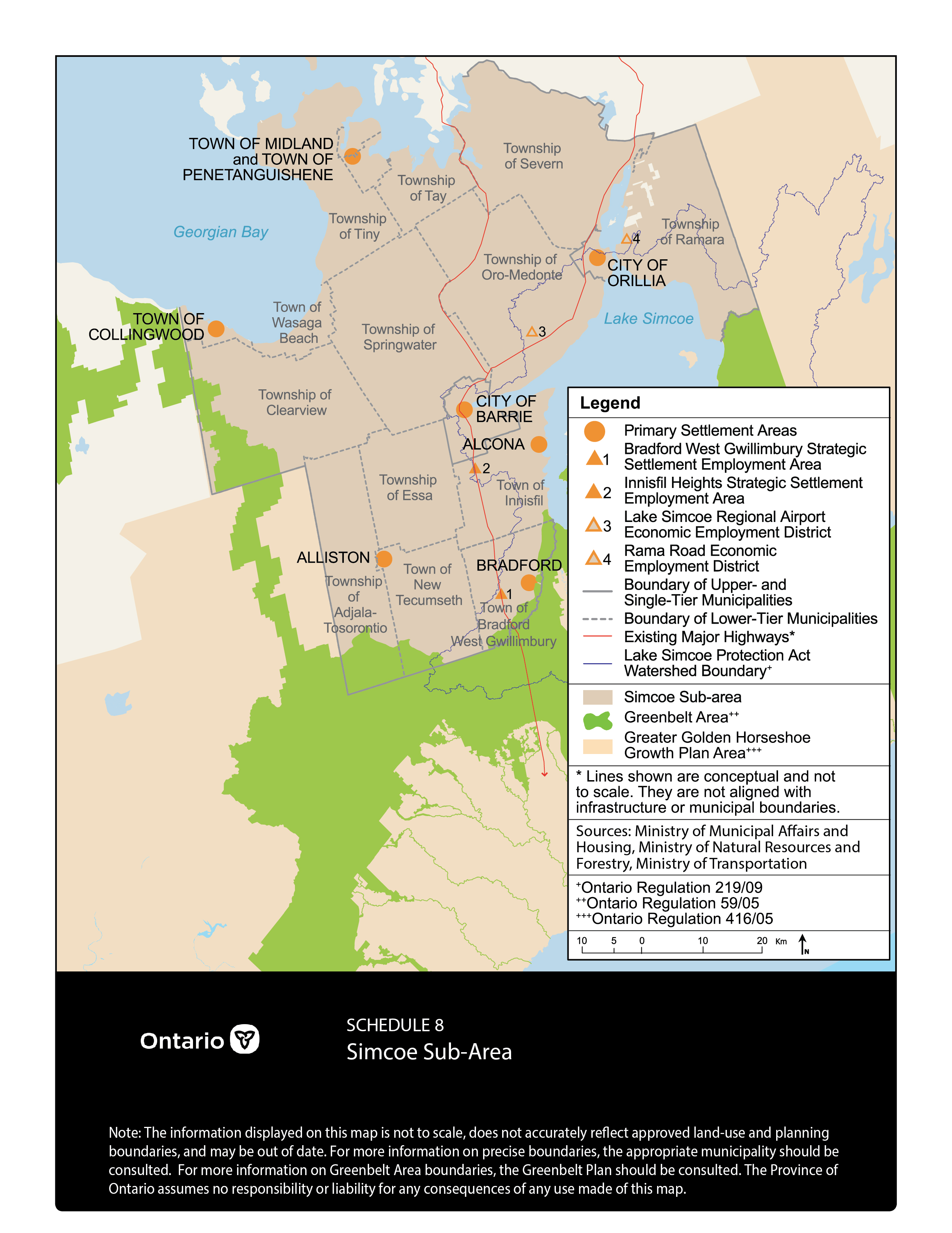
Schedule 8 - Simcoe Sub-Area
Note: The information displayed on this map is not to scale, does not accurately reflect approved land-use and planning boundaries, and may be out of date. For more information on precise boundaries, the appropriate municipality should be consulted. For more information on Greenbelt Area boundaries, the Greenbelt Plan should be consulted. The Province of Ontario assumes no responsibility or liability for any consequences of any use made of this map.
Amendment 2 (2013) to the Growth Plan for the Greater Golden Horseshoe, 2006
Introduction
5. Implementation and Interpretation
6. Simcoe Sub-area
7. Definitions
8. Schedules
Introduction
1.1 is amended by deleting “to 2031” in the second sentence of the third paragraph.
1.2 is amended by replacing “ 2031” with “ 2041” in the title.
1.2.1 is amended by replacing “ 2031” with “ 2041” in the first sentence of the first paragraph.
1.4 is amended by replacing “ 2031” with “ 2041” in the second sentence of the second paragraph.
5. Implementation and Interpretation
5.3 is amended by inserting the following after 4 f):
“5. Development of a new methodology for measuring and forecasting employment.”
5.4 is amended by inserting the following after 5.4.4.3:
“5.4.5 Transition"
- Schedule 3 forecasts shall be implemented by applying:
- Only the 2031A forecasts to:
- all upper- and single-tier municipal official plans, including amendments or requests for an amendment, commenced on or after June 16, 2006 but before June 17, 2013; and,
- all official plans, including amendments or requests for an amendment, commenced before June 16, 2006 and required to be continued and disposed of in accordance with this Plan;
- Only the 2031A forecasts, as allocated by the upper-tier municipality pursuant to policy 5.4.2.2(a) or by the Minister of Infrastructure pursuant to policy 5.4.2.3, to all lower-tier municipal official plans, including amendments or requests for an amendment, commenced before the applicable upper-tier municipal official plan is amended to conform with the Updated Forecasts;
- Only the 2031A forecasts to all zoning by-laws, including amendments, applications for an amendment to a zoning by-law, applications for approval of a plan of subdivision, and applications for the approval of, or an exemption from an approval of, a condominium, commenced before all official plans applicable to the lands affected by these matters are amended to conform with the Updated Forecasts;
- Only the forecasts contained in Schedule 7 for the Simcoe Sub-area to:
- all upper- and single-tier municipal official plans, including amendments or requests for an amendment, commenced on or after June 16, 2006 but before June 17, 2013;
- all official plans, including amendments or requests for an amendment, commenced before June 16, 2006 and required to be continued and disposed of in accordance with this Plan;
- all lower-tier municipal official plans, including amendments or requests for an amendment, commenced before the Simcoe County official plan is amended to conform with the Updated Forecasts; and
- all zoning by-laws, including amendments, applications for an amendment to a zoning by-law, applications for approval of a plan of subdivision, and applications for the approval of, or an exemption from an approval of, a condominium, commenced before all official plans applicable to the lands affected by these matters are amended to conform with the Updated Forecasts; and
- The Updated Forecasts to any planning matter other than those listed in 5.4.5.1 a), 5.4.5.1 b), 5.4.5.1 c) and 5.4.5.1d).
- Only the 2031A forecasts to:
- Notwithstanding policy 1.4, for the planning matters referred to in policy 5.4.5.1 a), 5.4.5.1 b), 5.4.5.1 c) and 5.4.5.1 d), the policies of this Plan are intended to be achieved by 2031.
6. Simcoe Sub-area
6.2.1 is amended by deleting “In the application of the policies of this Plan," in the Simcoe Sub-area
Schedule 7 will be applied instead of "Schedule 3”.
6.2.2 is amended to by deleting “in Schedule 7”.
6.3.1.4 is amended by deleting “in Schedule 7” in the first sentence.
6.5.3 is amended by adding “where this Plan allocates growth forecasts to the lower-tier municipalities in the County of Simcoe,” after " 5.4.2.2 (c)”, and by deleting “of Simcoe” in the first sentence.
7. Definitions
The list of definitions is amended by inserting the following definition after the definition of Affordable:
“Amended to Conform
An official plan is amended to conform to this Plan when a new official plan or an official plan amendment being made to bring the municipal official plan into conformity with this Plan, as required pursuant to section 12 of the Places to Grow Act, 2005, is final and the new official plan or the official plan amendment is in effect.”
It is also amended by inserting the following definition after the definition of Built Boundary:
“Commenced
For the following matters, the matter was started:
- in the case of a request for an official plan amendment under section 22 of the Planning Act, on the day the request is received;
- in the case of an official plan, an amendment to it or a repeal of it, under section 17 or section 26 of the Planning Act, on the day the by-law adopting the plan, amendment or repeal is passed;
- in the case of a zoning by-law or an amendment to it, under section 34 of the Planning Act, on the day the by-law is passed;
- in the case of an application for an amendment to a zoning by-law under section 34 of the Planning Act, on the day the application is made; and
- in the case of an application for the approval of a plan of subdivision under section 51 of the Planning Act, or an application for the approval of, or an exemption from an approval of, a condominium under section 9 of the Condominium Act, 1998, on the day the application is made.”
It is also amended by inserting the following definition after the definition of Outer Ring:
“Planning Matter
Any matter listed under commenced or:
- an application for an approval of development in a site plan control area under subsection 41(4) of the Planning Act;
- an application for a minor variance under section 45 of the Planning Act;
- an application to amend or revoke an order made under section 47 of the Planning Act; or
- an application for a consent under section 53 of the Planning Act.”
8. Schedules
Schedule 3 - Distribution of Population and Employment for the Greater Golden Horseshoe to 2041
| Region | Population 2031A | Employment 2031A | **Population 2031B | **Population 2036 | **Population 2041 | **Employment 2031B | **Employment 2036 | **Employment 2041 |
|---|---|---|---|---|---|---|---|---|
| Region or Durham | 960 | 350 | 970 | 1,080 | 1,190 | 360 | 390 | 430 |
| Region of York | 1,500 | 780 | 1,590 | 1,700 | 1,790 | 790 | 840 | 900 |
| City of Toronto | 3,080 | 1,640 | 3,190 | 3,300 | 3,400 | 1,660 | 1,680 | 1,720 |
| Region of Peel | 1,640 | 870 | 1,770 | 1,870 | 1,970 | 880 | 920 | 970 |
| Region of Halton | 780 | 390 | 820 | 910 | 1 000 | 390 | 430 | 470 |
| City of Hamilton | 660 | 300 | 680 | 730 | 780 | 310 | 330 | 350 |
| GTHA total | 8,620 | 4,330 | 9,010 | 9,590 | 10,130 | 4,380 | 4,580 | 4,820 |
| County of Northumberland | 96 | 33 | 100 | 105 | 110 | 36 | 37 | 39 |
| County of Peterborough | 61 | 18 | 70 | 73 | 76 | 20 | 21 | 24 |
| City of Peterborough | 88 | 42 | 103 | 109 | 115 | 52 | 54 | 58 |
| City of Kawartha Lakes | 100 | 27 | 100 | 101 | 107 | 29 | 30 | 32 |
| County of Simcoe | See schedule 7 | See schedule 7 | See schedule 7 | 456 | 497 | See schedule 7 | 141 | 152 |
| City of Barrie | See schedule 7 | See schedule 7 | See schedule 7 | 231 | 253 | See schedule 7 | 114 | 129 |
| City of Orillia | See schedule 7 | See schedule 7 | See schedule 7 | 44 | 46 | See schedule 7 | 22 | 23 |
| County of Dufferin | 80 | 27 | 80 | 81 | 85 | 29 | 31 | 32 |
| County of Wellington | 122 | 54 | 122 | 132 | 140 | 54 | 57 | 61 |
| City of Guelph | 175 | 92 | 177 | 184 | 191 | 94 | 97 | 101 |
| Region of Waterloo | 729 | 366 | 742 | 789 | 835 | 366 | 383 | 404 |
| County of Brant | 47 | 19 | 49 | 53 | 57 | 22 | 24 | 26 |
| City of Brantford | 126 | 53 | 139 | 152 | 163 | 67 | 72 | 79 |
| County of Haldimand | 56 | 20 | 57 | 60 | 64 | 22 | 24 | 25 |
| Region of Niagara | 511 | 218 | 543 | 577 | 610 | 235 | 248 | 265 |
| Outer ring total* | 2,880 | 1,240 | 2,940 | 3,150 | 3,350 | 1,280 | 1,360 | 1,450 |
| Total GGH* | 11,500 | 5,560 | 11,950 | 12,740 | 13,480 | 5,650 | 5,930 | 6,270 |
Note: Numbers rounded off to nearest 10,000 for GTHA municipalities, GTHA total and Outer Ring total, and to nearest 1,000 for outer ring municipalities.
* Total may not add up due to rounding.
** Updated forecasts.