Blue Lake Provincial Park Management Plan
This document provides direction on the management of Blue Lake Provincial Park.
©2012, Queen’s Printer for Ontario
Printed in Ontario, Canada
Additional copies of this publication are available from the Ministry of Natural Resources at the following location:
Blue Lake Provincial Park
c/o Ministry of Natural Resources
479 Government Road
P.O. Box 730
Dryden, ON P8N 2Z4
Cette publication hautement spécialisée Blue Lake Provincial Park Management Plan n'est disponible qu'en anglais en vertu du Règlement 411/97 qui en exempte l'application de la Loi sur les services en français. Pour obtenir de l'aide en français, veuillez communiquer avec Michele Proulx au ministère des Richesses naturelles au michele.proulx@ontario.ca.
4219-2
0.0k P.R. 20-08-12
ISBN-978-1-4435-9999-3 (PDF)
Approval Statement
I am pleased to approve the Blue Lake Provincial Park Management Plan as the official policy for the management and development of this park. The plan reflects the intent of the Ministry of Natural Resources, Ontario Parks to protect the natural and cultural features of Blue Lake Provincial Park and to maintain and develop opportunities for high quality outdoor recreation experiences and heritage appreciation for the residents of Ontario and visitors to the province.
This document outlines an implementation strategy for the plan’s elements and summarizes the Aboriginal and public involvement that occurred as part of the planning process. Consultation occurred at the terms of reference and preliminary park management plan stages. Consultation activities included direct notices, newspaper advertisements, the Ontario Parks' website and postings on the Environmental Bill of Rights, 1993 registry.
The plan for Blue Lake Provincial Park will be used to guide the management of the park over the next twenty years. During that time, the management plan may be reviewed to address changing issues or conditions, and may be amended as the need arises. This plan will be examined in accordance with the provisions of the Provincial Parks and Conservation Reserves Act, 2006 in 10 years.
I wish to extend my sincere thanks to all those who participated in the planning process.
Yours truly,
Signed by:
Michael Gravelle
Minister of Natural Resources
Date:
June 27, 2012
Provincial Parks and Conservation Reserves Act
The Provincial Parks and Conservation Reserves Act, 2006 (PPCRA) has two specific principles that guide all aspects of planning and management of Ontario’s system of provincial parks and conservation reserves:
- Maintenance of ecological integrity shall be the first priority and the restoration of ecological integrity shall be considered
- Opportunities for consultation shall be provided. 2006, c. 12, s. 3
Statement of Environmental Values and the Environmental Bill of Rights
The Ministry of Natural Resources' Statement of Environmental Values (SEV) under the Environmental Bill of Rights (EBR) describes how the purposes of the EBR are to be considered whenever decisions are made in the Ministry that might significantly affect the environment. This includes decisions made as a result of preparing management direction for a protected area.
The Ministry’s SEV has been considered throughout the planning process. The management direction for Blue Lake Provincial Park will further the objectives of managing Ontario’s resources on an environmentally sustainable basis.
Planning Context
This park management plan has been prepared consistent with direction contained in Our Sustainable Future, Ministry of Natural Resources Strategic Directions, 2011, in Protecting What Sustains Us: Ontario’s Biodiversity Strategy, 2005 and in Ontario Provincial Parks: Planning and Management Policies (1992 update). Additionally, Blue Lake Provincial Park will be managed to protect any species at risk (SAR) and their habitat in a manner consistent with the Endangered Species Act, 2007 (ESA). All activities undertaken in Blue Lake Provincial Park must comply with A Class Environmental Assessment for Provincial Parks and Conservation Reserves (Class EA-PPCR), where applicable.
All activities undertaken in Blue Lake Provincial Park must comply with A Class Environmental Assessment for Provincial Parks and Conservation Reserves (Class EA-PPCR; OMNR 2005c), where applicable.
Aboriginal Context
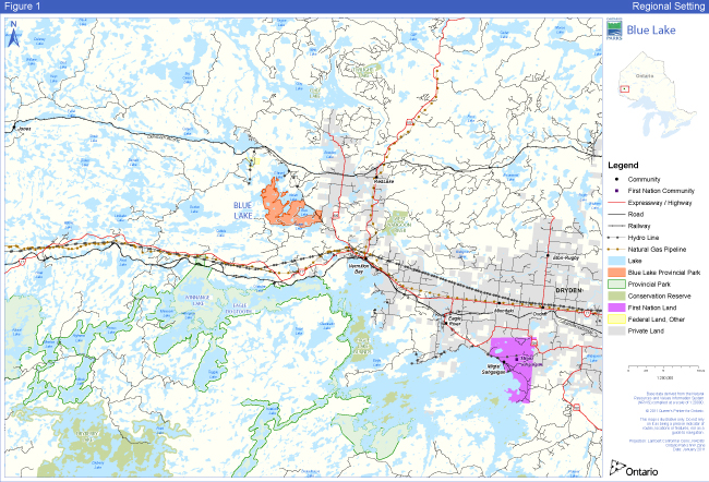
Wabigoon Lake, Wabauskang, Grassy Narrows (English River), Eagle Lake, Ojibway Nation of Saugeen, and Lac Seul First Nations are nearby and are all within the boundary described by Treaty #3 (Figure 1). Blue Lake Provincial Park overlaps traditional lands and waters of these six Aboriginal communities. These communities use the area for hunting, trapping, fishing, gathering, cultural purposes and travel and were invited to participate during the development of this management plan.
Blue Lake Provincial Park is located near two Métis Nation of Ontario (MNO) asserted harvesting territories; lake of the Woods/Lac Seul and Rainy Lake/Rainy River. The closest community councils that may have an interest include Northwest (Dryden), Kenora, Sunset Country (Fort Frances), and Atikokan Métis Councils. The Aboriginal Peoples of Wabigoon are also located in the area.
Aboriginal communities use the area for hunting, trapping, fishing, gathering and travel.
Respect for and protection of archaeological and cultural features are integral to this park management plan. The First Nations and Aboriginal communities shall be involved on related issues of concern during the implementation of this plan.
Figure 1: Regional Setting
Enlarge Figure 1: Regional Setting
1.0 Introduction
Blue Lake Provincial Park was established in 1957 and was classified as a recreation park. In 1999, an addition to Blue Lake Provincial Park (P2347) was recommended in Ontario’s Living Legacy (OLL) to increase in size by 1,960 hectares, as well as to change the park classification from recreation to natural environment. The provincial park addition was established in May 2003. The total current area included within the expanded park is approximately 2,314 hectares.
Blue Lake Provincial Park is well known for its 800-metre long sand beach and the inviting waters of Blue Lake. The expansion of the park provides a more diverse park experience and meets park size standards for natural environment parks. The site is typical Canadian Shield terrain, with a part of the Eagle-Finlayson Moraine running in a north-west by south-east direction. Dominant tree species found in the area include those typically found in the boreal forest. As a result of the naturally occurring association between vegetation and landforms, the expanded park provides a unique representation of features found within Ecodistrict 4S-5.
The OLL addition to Blue Lake Provincial Park represents an approximate five-fold increase in park size. It encompasses an area to the west and north of the existing park, surrounded by Indian Lake on the east, Edward Lake on the north and northeast, and Cobble and Brownie lakes on the west. The addition is an irregular piece of land without internal rivers or lakes. It is characterized by weakly to broken bedrock rock knobs within a flat, to very weakly broken clay plain.
Blue Lake Provincial Park is situated 50 kilometres west of Dryden, 100 kilometres east of Kenora, and nine kilometres north of the Trans-Canada Highway (17), close to the town of Vermilion Bay. Road access to Blue Lake Provincial Park is provided by Highway 647 via the main park road. Access to the park may also be gained from the waters of Blue, Corner (Langton), Whitney, Brownie, Edward, Cobble and Indian lakes. An abandoned forest access road provides limited access into the western portion of the park addition, north of Brownie Lake.
Its close proximity to the Trans-Canada Highway (17) and other settled areas on the Dryden clay plain suggests that some agricultural activities may have occurred in the past. Current uses relate principally to recreational activities on the surrounding lakes. These lakes have numerous private cottages and commercial tourist lodges, and as a result, boat traffic can be quite high. Potential impacts from these activities could include shore erosion from boat wakes (particularly given the dominance of clay banks), uncontrolled landings and camping.
Park visitors are drawn from surrounding communities including Winnipeg, who use the park as a vacation destination for camping, swimming, boating and hiking. The park experiences heavy use in July and August.
A management plan for Blue Lake Provincial Park was completed in 1991. A management plan re-write is required to address the significant OLL additions to the park’s land base.
This park management plan will guide the management, operation and development of Blue Lake Provincial Park over the next 20 years. The plan will be examined in 10 years and amended as the need arises; Section 13 describes the process for review and amendment of the plan.
The Blue Lake Provincial Park Management Plan has been developed in accordance with the Ontario Provincial Parks: Planning and Management Policies (OMNR 1992), Ontario’s Living Legacy Land Use Strategy (OMNR 1999) and approved land use policies as reflected by the Crown Land Use Policy Atlas (CLUPA; except where changes are proposed by this plan). In accordance with this plan, the MNR will amend affected area-specific land use policies and mapping found in the CLUPA.
2.0 Classification
Through park classification, Ontario’s provincial parks are organized into broad categories, each of which has particular purposes and characteristics.
When Blue Lake Provincial Park was originally established, it was classified as a recreation park because of the recreational opportunities it offers. OLL recommended the reclassification of Blue Lake Provincial Park from recreation to natural environment, in order to meet the natural environment park class target for Ecodistrict 4S-5. Natural environment parks incorporate outstanding recreational landscapes with representative natural features and cultural resources. These parks provide high quality recreational and educational experiences. Blue Lake Provincial Park fulfills the park class representation target for natural environment parks in Ecodistrict 4S-5 (Lake Wabigoon Site Region - Upper English River).
3.0 Goal
To protect the outstanding landscape and provincially and regionally significant natural and cultural features of Blue Lake Provincial Park and to provide opportunities for ecologically compatible heritage education, outdoor recreation, and scientific research activities.
Blue Lake Provincial Park is governed by the PPCRA, and Ontario Provincial Parks: Planning and Management Policies (OMNR 1992), and Ontario’s Living Legacy Land Use Strategy (OMNR 1999).
4.0 Objectives
There are four objectives for the Ontario provincial parks system: protection, recreation, heritage appreciation and scientific research.
4.1 Protection Objective
To permanently protect representative ecosystems, biodiversity and provincially significant elements of Ontario’s the natural and cultural heritage of Ontario and to manage these areas to ensure that ecological integrity is maintained.
Provincial parks play an important role in representing and conserving the diversity of Ontario’s natural features and ecosystems, across the broader landscape. Protected areas include representative examples of life and earth science features, and cultural heritage features within ecologically or geologically defined regions. Ontario’s ecological classification system provides the basis for the life science feature assessment, and the geological themes provide the basis for earth science assessment.
4.1.1 Life Sciences
Blue Lake Provincial Park is situated in Ecodistricts 4S-4 (Dryden) and 4S-5 (Manitou) and represents an area typical of the Canadian Shield of northwestern Ontario. The park is located near the southern edge of the Lower English River section of the Boreal Forest Region (Thacker 1974). This section is delineated by the influence of glacial Lake Agassiz. The forest cover is representative of the Boreal Forest Region. The forest complex is representative of pioneer and intermediate communities which have become established on dry to mesic sites after fire (Noble 1977).
The proximity of the Great Lakes-St. Lawrence forest introduces species atypical of the boreal forest. These include red maple, black ash, red pine, and white pine. The associated ground flora also reflects the Great Lakes-St. Lawrence forest to some extent and can include species such as wild ginger, nodding trillium and the large round-leaved orchid (Thacker 1974).
The area encompassed by Blue Lake Provincial Park contains plant communities and species of local significance. A black ash stand within Blue Lake Provincial Park is near the northern edge of its range. This stand occurs on deep well-drained soil on a peninsula jutting into Indian Lake. Species composition in this area ranges from almost pure black ash in nearshore areas, to a mixedwood stand, also including black spruce, balsam fir and aspen in upland areas. Also occurring with black ash is speckled alder, wild ginger, nodding trillium, hairy willow herb and northern bugleweed. This stand also has a relatively high diversity of ferns, including crested wood fern, long beech fern, oak fern, and spinulose wood fern.
Although relatively uncommon in the region, eastern white cedar exists in the park on deep clay sites. Cedar stands tend to have relatively continuous canopy, with some white spruce scattered throughout. Other species in these stands include balsam fir, lesser pyrola and sweet coltsfoot. The ground cover is typically extensive moss, dominated by stair-step moss.
Wetland communities within Blue Lake Provincial Park include floating bog mats, shrub fens, and cattail and sedge marshes. Bog mats tend to be dominated by sphagnum, with scattered black spruce and tamarack. Fens tend to be dominated by sedges and have a scattered covering of small black spruce. Marshes include various species of Carex, as well as cattails, reed canary grass, cotton grass, sweet gale and leather-leaf. The black spruce bog in the original park is more representative of the Arctic and Hudsonian zones to the north (Thacker 1974).
The wildlife of Blue Lake Provincial Park is representative of the Boreal Forest Region. Mammals include moose, white-tailed deer, black bear, timber wolf, lynx, American marten, red fox, snowshoe hare, river otter, and beaver.
More than 90 bird species have been identified in the park. The birds of the park are typical of the boreal forest and include a wide variety of songbirds, raptors, shore birds, and waterfowl.
The wetlands provide excellent habitat for amphibians and reptiles. Species identified to date include the leopard frog, boreal chorus frog, spring peeper and American toad. The eastern garter snake and the western painted turtle are also found in the park.
Blue Lake Provincial Park is located within Fisheries Management Zone 5. Alternative species such as small mouth bass have been introduced into Indian, Blue, Edward, Whitney, and Cobble Lakes.
Blue Lake is a spring fed lake with only one outlet, a creek that drains into Corner Lake to the south. There is a varied fishery in Blue Lake including lake trout, walleye, smallmouth bass and muskellunge. The Dryden District Fisheries Management Plan has identified Blue Lake as one in which the use of alternative species, such as small mouth bass, will be promoted (OMNR 1987).
Corner and Indian Lakes are eutrophic lakes containing walleye, muskellunge, and small mouth bass. A Community Fisheries Involvement Programme project was completed at the rapids between Corner and Indian lakes to prevent pike from getting from Corner Lake into the Indian Lake chain.
4.1.2 Earth Sciences
Blue Lake Provincial Park lies within the Canadian Shield. Granitic bedrock outcrops with a thin discontinuous soil cover dominate the western portion of the park, while the eastern portion is covered by an end (or recessional) moraine.
The bedrock geology of Blue Lake Provincial Park is principally massive granites with gneissic banding. The park lies within the Wabigoon Subprovince of the Superior Province. Bedrock exposures provide representation of the Archean Era of the Precambrian (Neo to Mesoarchean, 2.5 to 3.4 billion years old). Kor (1977a) noted the bedrock within the former extent of Blue Lake Provincial Park as being a "representative and excellent incorporation of a granitic terrain somewhat typical of northern Ontario" and the terrain of the Wabigoon Belt. The OLL park addition adds to this representation.
Geomorphology
The first major halt in the retreat of the Wisconsin glaciation formed the Eagle-Finlayson moraine, which occurs in the eastern portion of Blue Lake Provincial Park. The Eagle-Finlayson Moraine is one of the largest and longest moraines in Ontario. A thin layer (up to 60 cm or 2 feet) of brown, stony, sandy till overlies the moraine and a series of boulder ridges exist on its north edge. The end moraine stands as a straight, narrow ridge separating the waters of Blue and Corner lakes from the lower-lying lands to the north of the moraine.
Evidence of Glacial Lake Agassiz occurs on the gently rolling bedrock plain (i.e. the Dryden Clay Plain) to the northeast of the Eagle-Finlayson moraine. It is composed of light grey to grey-brown firm, silty clay or clay which occupies depressions in the bedrock topography. The clay plain is frequently broken by rock knobs which are either bare or are covered by a thin veneer of stony, sandy till. Granite sand and gravel occur in the elongated ridges or in isolated knolls. The poorly drained basins in the clay plain are occupied by peat deposits, which occasionally cover areas up to 25 square kilometres.
The bedrock-controlled terrain in the western area of Blue Lake Provincial Park is overlain by glacial drift. The outcrop areas usually contain a thin veneer of sandy silt. Between the outcrops, the low-lying poorly drained areas have been overburdened with a silty clay material. This fine sediment originated, in part, in the moraine and from sediment carried by glacial ice. It was carried from the beach and near shore area of the glacial lake by the energy of the runoff streams and the nearshore beach erosion.
The coarser grained sand in the beach area was also derived from the moraine. Wave action washed moraine material was deposited in the nearshore areas of the glacial Lake. Boulder concentrations can be seen along the length of the moraine. These represent the wave-washed core of the moraine.
Representative landform complexes occurring within the Blue Lake Provincial Park addition include:
- Flat to very weakly broken deep glaciolacustrine silty clay and silt;
- Weakly to moderately broken rock knob flanked by silty sand till (ground moraine); and
- Weakly to moderately broken rock knob flanked by glaciolacustrine silty clay deposits.
The glaciolacustrine deposits within the Blue Lake Provincial Park addition are considered to be representative of the Dryden Clay Plain deposited within glacial Lake Agassiz. Although represented in other parks and reserves, this occurrence is particularly significant. The relatively large extent of the clay plain, the occurrence of easily accessible rhythmite exposures (deep-water fine-grained sediments laid down in an annual cycle of freeze and thaw), and the variation in sediment grain size characteristics present over the area, suggest at least a regionally significant designation. The close proximity of these features to the existing provincial park and the recreational facilities located in the park, allow for high potential values for educational and interpretive uses. In addition, the rhythmite exposures and nature of sediment facies changes may provide scientific value, with regard to the interpretation of events associated with glacial Lake Agassiz high water and transition stages.
The eastern third of the Blue Lake Provincial Park addition, particularly adjacent to the existing park and the area between Indian Lake and Blue Lake consists of weakly to moderately broken bedrock knobs with pockets of silty sand till (ground moraine) flanking the bedrock outcrops. The terrain becomes more subdued to the west due to the presence of deep glacial Lake Agassiz silty clays and clays forming broad plains between rock knobs. These grey to brownish-grey clays form the banks of large sections of Indian, Edward and Cobble lakes, with some exposures showing well formed rhythmite
4.1.3 Cultural Heritage Resources
Cultural features are specific locations that host the physical traces, and their associated values, of past human occupation or activity.
To date, there have been no archaeological sites identified within the boundaries of Blue Lake Provincial Park or its addition.
4.2 Recreation Objective
To provide opportunities for ecologically-sustainable outdoor recreation and encourage associated economic benefits.
Blue Lake Provincial Park offers opportunities for car camping in the campground. Park-related activities enjoyed most by campers include resting/relaxing (95%), swimming /wading (88%), trail hiking (82%), fishing (76%), using playground equipment (52%), biking (50%), nature viewing/lookouts (49%), picnicking (44%), motorboating (23%), canoeing (22%) (Ontario Parks 2008).
Day-users are local residents, mostly from the Dryden and Kenora areas. Day-users visiting Blue Lake Provincial Park are primarily members of family groups participating in picnicking, relaxing, walking on the beach, swimming or wading. There are also corporate and other groups who use the park for picnics and events.
Interior camping opportunities are available in the Blue Lake Provincial Park addition. These are in association with canoe route #12, Blue Lake Loop, which begins and ends at Blue Lake Provincial Park. Canoeists use shoreline campsites on Indian, Edward and Whitney lakes (Figure 4).
The addition to Blue Lake Provincial Park also provides opportunities for hiking (Goblin Lake Loop) and All Terrain Vehicle (ATV) use on old forest access roads (west of Brownie Lake). The lakes adjacent to the addition are popular with recreational boaters. High quality sport fishing for walleye and lake trout occurs on these lakes, which are reached by designated access points on Corner, Indian, Edward and Forest.
The sand beaches on Indian and Blue lakes are popular swimming/wading areas for local residents. The cliffs that are located on the northwest shore of Blue Lake are a popular viewing and swimming destination.
Hunting in the park addition (NE2 zone) for large game and game birds, occurs in the autumn, in association with old forest access roads.
Winter day-use for Blue Lake Provincial Park is minimal, consisting of ice fishing, some use of motorized snow vehicle and cross-country skiing. Winter day-use is primarily local in origin.
There are three motorized snow vehicle trails that provide access to Goblin, Indian and Brownie lakes; these trails are also used to gain access for ice fishing on the lakes. The most popular route follows the Blue, Corner, Indian, Whitney, and Edward Lake chain.
Blue Lake Provincial Park is a destination park where most campers come to stay as part of their vacation. In response to the query regarding type of trip, 88.8% indicated that it was a vacation trip, 7.9% indicated it was one of several destinations and 2.4% said that they were stopping over en route (Ontario Parks 2008).
In 2008, most visitors to Blue Lake Provincial Park (72.3%) were from western Canada (Manitoba), 25.2% from northwestern Ontario and 0.6% from the American midwest, specifically Minnesota, Wisconsin and Michigan. The 2008 camper origins for the northwest zone show that 47.4% originated in Ontario, 46.5% originated in western provinces and 5.9% came from the United States. This is in contrast to the 2008 origins of park users on a province-wide basis where the majority of park visitors (81.3%) came from southern, eastern and central parts of Ontario (including the GTA), 9.3% originated in northern Ontario, 6.9% originated in other provinces and 2.4% of visitors came from the United States (Ontario Parks 2008).
4.3 Heritage Appreciation Objective
To provide opportunities for residents of Ontario and visitors to increase their knowledge and appreciation of Ontario’s natural and cultural heritage.
Blue Lake Provincial Park is designated as a seasonal activity program level, meaning comprehensive information / orientation services, as well as self-use facilities such as trails, are offered. Blue Lake Provincial Park has an activity building from which the Natural Heritage Education (NHE) program is administered.
4.4 Scientific Research Objective
To facilitate scientific research and to provide points of reference to support monitoring of ecological change on the broader landscape.
Ontario’s provincial parks play an important role to undertake research activities in order to: provide a better understanding of park environments, contribute to appropriate park management practices and actions, and to provide baseline ecological information that can be used to support the ecological monitoring on the broader landscape.
5.0 Boundary
Blue Lake Provincial Park was established in 1957, (Ontario regulation 144/57) and was classified as a recreation park. In 1999, Blue Lake was recommended in Ontario’s Living Legacy (P2347) to increase in size by 1,951 hectares, as well as to change the classification from recreation to natural environment. When combined, the total area included within the expanded park complex is approximately 2,314 hectares. The Blue Lake addition was regulated in May 2003 under Ontario regulation 210/03 (Figure 4).
In the original park, the boundary is generally set 91 metres from the waters' edge. In the addition, the boundary is set 91 metres from the waters edge on Blue and Corner lakes and at the water’s edge on Indian, Edward, Whitney and Brownie lakes. The following is a brief description of land tenure in the park and surrounding area:
- There are approximately 22 private cottages and twelve year-round residences on Blue Lake outside of the park and one commercial enterprise (store) which is adjacent to the north boundary of the park.
- A number of commercial tourist lodges are situated on nearby lakes.
- There are several patent land parcels adjacent to the boundary of the addition, including SRL EB 1902 (Parcel 21879), SRL EB 1731 (Parcel 20476), SRL EB 1685 (Parcel 21063), Lot 15, plan m-381 (Parcel 20360) and Ministry of Transportation Highway 647.
Park management plan policies apply only to the area within the regulated boundary of the park. Within the park boundary, the protection of park values and features will be achieved through appropriate zoning, control of land use and activities, education, and monitoring of ecological impacts.
Ontario Parks will support, in principle, the acquisition of property for addition to the park, if the acquisition will enhance the values of the park. Acquisition or securement will be subject to funding and willingness of the owners to sell or lease their properties or enter into a conservation easement.
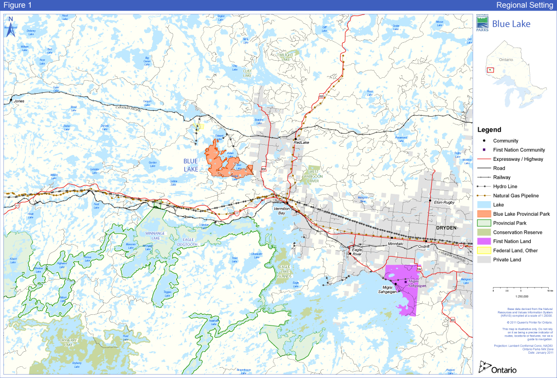
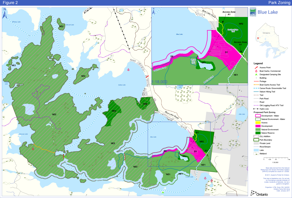
6.0 Zoning
Lands within Blue Lake Provincial Park are zoned in accordance with their environmental and cultural features and values, and their sensitivity to development. The four zoning categories designated for Blue Lake Provincial Park include nature reserve, access, development and natural environment (Figure 2) and are based on the Ontario Provincial Parks: Planning and Management Policies (OMNR 1992). The zones differentiate the sensitivity of the natural and cultural values, and the permissible degree of development, recreational uses and management practices within the park.
6.1 Nature Reserve Zones
Nature reserve zones protect the provincially significant earth and/or life science features within a park, and may include a protective buffer area in which a minimum of development is permitted. Development is generally restricted to trails, necessary signs, interpretive facilities (where warranted) and temporary facilities for research and management.
NR1 Canoe Lagoon, 12 hectares
NR1, the Canoe Lagoon nature reserve zone protects the floating poor fen, bisected by moving water between Blue and Corner Lakes. The fen also provides habitat for several orchid species and the carnivorous sundew and pitcher plant.
Figure 2: Park Zoning
NR2 Clay plain and moraine, 55 hectares
NR2 includes part of the Eagle-Finlayson moraine north east of the highway and includes a portion of the adjacent Dryden Clay Plain. Both of these features are regionally significant earth science features. This zone also protects habitat for the large round-leaved orchid, as well as typical Great Lakes-St. Lawrence forest species including wild ginger, and nodding trillium.
NR3 Black Ash Stand, 44 hectares
NR3 protects a locally significant black ash stand, which contains species such as black ash and nodding trillium that are near the northern limit of their ranges.
NR4 Bog-marsh Complex, 22 hectares
NR4 protects the locally significant shrub bog-sheltered marsh complex, which is not found elsewhere in the park.
6.2 Development Zones
Development zones contain the area(s) of the park geared towards the support of intensive day-use and car camping activities. They constitute a relatively small portion of most parks. Development may include roads, visitor control structures, beaches, picnic areas, car campgrounds, commercial service facilities, maintenance facilities, park office and orientation, interpretive, educational, research and management facilities.
D1 Campground and Day-use, 43 hectares
User activity and facility development of the original park is concentrated in D1 (campground and day-use). Development consists of campgrounds, day-use areas, the park administrative complex, and a small gravel pit that is no longer used. D1 is generally south of Highway 647, restricted to the moraine-top jack pine forest and bounded on the east and west by Blue Lake and the emergency access road respectively.
D2 South Shore of Blue Lake, 8 hectares
The D2 zone is approximately 1000 metres of shoreline of Blue Lake, with a setback of 80 metres. It is located adjacent to the D1 zone. The D2 zone was originally designated for the development of remote walk-in/boat-in campsites but this has not yet occurred.
6.3 Access Zone
Access zones serve as staging areas, a means of both providing and regulating use in areas of a park geared towards recreation. Generally, development is limited to roads, visitor control structures and group campgrounds. Provisions may be made for limited orientation, interpretive or educational facilities, though generally more for self-use rather than through structured personal service. Limited facilities for research and park management may also be present.
A1 Ontario Federation of Snowmobile Clubs (OFSC) access, 3 hectares
A 500 metre long section of the six-metre wide corridor associated with the OFSC trail which passes along the perimeter of the NR2 zone is designated access zone A1. Current use of NR2 by motorized snow vehicles is in contravention of existing park policy. This re-designation brings this activity into compliance with park policy, permitting it to continue.
6.4 Natural Environment Zones
Natural environment zones permit the minimum level of development to support low-intensity recreational activities. Development is generally limited to back-country campsites, portages, necessary signs and minimal interpretive facilities.
NE1 228 hectares
The remainder of the original park is designated as natural environment zone NE1. This zone includes a small portion of the Eagle-Finlayson moraine. It is intended to provide opportunities for nature appreciation and low-intensity day-use recreation, supported by minimum development such as trails, signs, minimal interpretative facilities, and simple facilities to support low-intensity recreational activities.
NE2 1,855 hectares
NE2 is typical Canadian Shield terrain, with additional sections of the Eagle-Finlayson Moraine. Dominant tree species include jack pine with white and black spruce, trembling aspen and some cedar. Locally significant plant species such as orchids and wild ginger are also present.
This zone will provide continued opportunities for interior camping in association with canoe route #12 (Blue Lake Loop), including the use of shoreline campsites on Indian, Edward and Whitney lakes. It is also intended to support continued opportunities for hiking (Goblin Lake Loop) and ATV use on old forest access roads (west of Brownie Lake). As well, it is intended to provide recreational boating, rock climbing, sport fishing, sport hunting, nature appreciation and low-intensity day-use recreation opportunities, supported by minimum development and interpretive facilities such as trails and signs.
7.0 Resource Stewardship Policiesfootnote 2
The stewardship of Blue Lake Provincial Park’s natural and cultural resources will conform to the policies identified for natural environment class parks in Ontario Provincial Parks: Planning and Management Guidelines (OMNR 1992) and Ontario’s Living Legacy Land Use Strategy (OMNR 1999). Additional policy direction is provided in the following section.
Resource stewardship initiatives may be accomplished through partnerships and sponsorships. All resource stewardship activities will be undertaken in accordance with requirements under the Class EA-PPCR, and Environmental Assessment Act, 1990 (EAA).
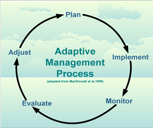
An adaptive management (Figure 3) approach will be applied to resource management activities within Blue Lake Provincial Park. Adaptive management allows for the modification of management strategies in response to monitoring and analysis of the results of past actions and experiences. Adaptive management is a systematic, practical approach to improving resource stewardship.
Figure 3: Adaptive Management Process
7.1 Aboriginal Uses of Natural Resources
Wabigoon Lake, Wabauskang, Grassy Narrows (English River), Eagle Lake, Ojibway Nation of Saugeen, and Lac Seul are nearby First Nations and are within the boundary described by the Treaty #3. Blue Lake Provincial Park overlaps the traditional lands and waters of these six First Nations, which use the area for hunting, trapping, fishing, wild rice harvesting, other gathering, and travel.
Blue Lake Provincial Park overlaps two Métis Nation of Ontario (MNO) asserted harvesting territories; Lake of the Woods/Lac Seul and Rainy Lake/Rainy River. The closest community councils that may have an interest include Northwest (Dryden), Kenora, Sunset Country (Fort Frances), Kenora and Atikokan Métis Councils. The Aboriginal Peoples of Wabigoon are also located in the area.
This plan recognizes the inherent rights of the First Nations and Aboriginal communities and acknowledges that their traditional activities in Blue Lake Provincial Park will not be affected by park policies, provided that safety and conservation concerns are not compromised.
7.2 Industrial / Commercial Uses
The following uses are not permitted within the Blue Lake Provincial Park boundary:
- Commercial forestry.
- Prospecting, staking mining claims, advanced exploration, working mines.
- Extraction of sand, gravel, topsoil or peat.
- Commercial electricity generation.
- Other industrial uses.
The following uses are permitted in the addition to Blue Lake Provincial Park (Figure 4):
- Two active traplines (DR39 and DR35).
- Three active Bear Management Areas (BMA; DR-7B-105, DR-7B-107, DR-07B-104).
- Two baitfish blocks (DR0006, DR0011), one of which is active.
7.3 Land Management
Management of the park’s land base will be directed toward maintaining the natural landscape.
- There are a number of commercial boat caches on the lakes abutting the park (Brownie Lake (1), Indian Lake (1), Forest Lake (1) and Cobble Lake (1).
- There are four formal access points that provide access to the addition (Corner, Edward, Forest and Indian lakes).
- An established canoe route (#12 Blue Lake Loop) begins and ends at Blue Lake.
MNR will not dispose of protected area land to individuals for private use.
Figure 4: Adjacent Land Use
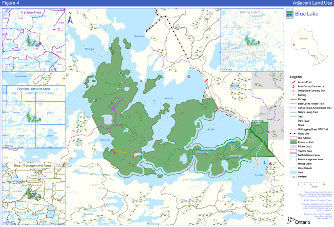
Enlarge Figure 4: Adjacent Land Use
7.4 Water Management
There are two aspects to water management in the park; natural water for fisheries and recreational purposes; and treated drinking water. Water management in the park will maintain good water quality and sufficient water flow for fisheries habitat and recreational purposes.
The potable water system for the campground was upgraded in 2003. Water quality will be monitored on a regular basis in the D1 development zone, in accordance with current Ontario Safe Drinking Water Regulations, and the Ontario Beach Management Protocol.
7.5 Forest Fire Management
Blue Lake Provincial Park is located within the Boreal West Forest Region. Fire is a major disturbance in this region and occurs more frequently and with greater severity on conifer dominated forests, compared to the less flammable deciduous forests.
Jack pine, upland white and black spruce, trembling aspen and isolated areas of cedar forests occur within Blue Lake Provincial Park. These forests are typically fire-maintained seral forests. Prior to settlement and fire protection, upland black spruce – jack pine forests likely experienced frequent, large stand replacing fires that usually killed the canopy trees and prevented the development of un-even aged stands (Van Sleeuwen 2006). Lowland areas consisting of cedar forested wetlands historically experienced infrequent to very infrequent stand replacement fires and were strongly influenced by fires intruding from adjacent ecosystems by interaction of insect and disease, blowdown and drought.
Blue Lake Provincial Park has experienced very little fire activity within the last 47 years. Since 1960, only six fires have occurred within park boundaries burning only 1.3 hectares of park area. These fires ranged in size from 0.1ha to 0.6 ha with smouldering and low intensity surface fire behaviour observed.
The Forest Fire Management Strategy for Ontario (OMNR 2004) provides strategic direction for the management of wildfire across Ontario. According to this provincial strategy, Blue Lake Provincial Park is located in the Boreal Fire Management Zone. This zone is associated with a high level of protection, with fires generally receiving aggressive initial attack and sustained action until extinguished.
Due to the size of the park, high visitor use, the close proximity to the community of Vermilion Bay, the highway 647 corridor and the number of private cottages adjacent to park boundaries, it is not feasible to allow forest fires to function freely, without putting values in and adjacent to the park at risk. As such, fire response options such as modified response or monitoring, or fire use options, such as prescribed fire, will not be used within Blue Lake Provincial Park. Any forest fire that occurs within the park will be suppressed.
To achieve park management objectives and promote and maintain ecological integrity, the fire use option of prescribed burning may be considered in order to perpetuate naturally occurring vegetation communities within the park. Opportunities for prescribed burning will be considered within the park to achieve ecological or hazard reduction objectives. Any prescribed burns will be planned and executed in accordance with MNR policy.
7.6 Species at Risk
There are no species at risk currently identified within the park. If, however, any are identified, they will be protected consistent with the ESA, 2007 and regulations.
7.7 Vegetation
Management of vegetation within the park will be directed toward maintaining an evolving natural succession of vegetation.
The vegetation of Blue Lake Provincial Park will continue to be managed as outlined in the existing Vegetation Management Plan (Ontario Parks 1997). Direction for management of the natural environment and nature reserve zones in the existing park includes the management of authorized trails, the removal of hazardous trees near trails, and visitor education regarding protection of sensitive plant communities. A similar management approach will be taken in the park addition. The Vegetation Management Plan will be amended and updated in order to explore ways to manage fire, and maintain the biodiversity and ecological integrity of the park, while balancing this with the needs of the park users.
The campground within Blue Lake Provincial Park provides additional challenges to vegetation management. The even aged jack pine forest in the campground has become susceptible to severe deterioration due to fire suppression. Compounding factors include soil compaction and lack of organic surface litter from the concentration of use at campsites, where visitors spend most of their time. There is evidence that site degradation is closely associated with site design. Development of camp site design alternatives, in relation to the above noted constraints, may mitigate some of the impacts of camping and improve the quality of recreational experiences. (OMNR 1980)
The removal of hazard trees will be permitted in all zones where safety is a concern (e.g. trails, and campgrounds). Areas experiencing adverse use impacts will be rehabilitated whenever possible, using plant species native to the park. Landscaping will be permitted in the development zones; effort will be made to incorporate natural features and exclusive use of native species to restore vegetation.
Infestations of forest insects and diseases will be monitored and assessed depending on available resources. Non-native species may be controlled in all zones, and native species may be controlled only in the development and access zones. If control measures are undertaken, they will be applied to minimize effects on the general park environment.
Brushing along primary and secondary roads, as well as along hiking trails will be permitted to improve sight lines and/or traffic flow.
Figure 5: Original Park Zoning
Enlarge Figure 5: Original Park Zoning
Herbicide applications will be discouraged for vegetation management. Mechanized or hand tending of the Hydro One corridor in the south east part of the park addition will be encouraged. Pesticides may be used to protect or enhance park values in accordance with Ministry of the Environment (MOE) regulations and MNR guidance.
Any development that requires the removal of vegetation other than hazard trees will be supported by a vegetation inventory, in accordance with approved site plans.
7.8 Wildlife
Hunting is permitted in the Blue Lake Provincial Park addition, as per Fish and Wildlife Conservation Act, 1997 (FWCA), (O. Reg. 207/03, s. 3). Hunting is not permitted in the original park (Figure 5).
There are portions of two traplines in Blue Lake Provincial Park. Licensed trapping will be permitted to continue. In the NR1 and NR2 zones in the original park, trapping by non-Aboriginal people may continue for the lifetime of the head trapper as of October 30, 2009. If a licence is revoked, surrendered or an application for transfer is received prior to that time, all portions of the registered trapline within the NR Zone will be rescinded from the trapline’s legal description. Existing traplines may be transferred to or between Aboriginal people. New operations, including trap cabins and trails, will not be permitted.
All trapping will be carried out in accordance with the FWCA. Trappers will be permitted to access their traplines by foot or mechanized travel (e.g. ATV or motorized snow vehicle).
New operations, including trapline cabins and trails, will not be permitted. The relocation of existing cabins and trails will be subject to ecological principles and management planning. In the park addition, transfer of active licences is permitted, subject to the review of potential impacts and the normal types of transfer or renewal conditions, that would apply within a protected area.
Wabigoon Area, of the Dryden District administers three BMAs licensed and operating within the park addition boundaries. BMAs are permitted to continue in natural environment zones of the park addition. BMAs in nature reserve zones will be removed from the BMA in regulation at the earliest opportunity. New BMA licences will not be issued in the park addition. An existing authorized BMA may be renewed or transferred.
Wildlife populations, mortally-wounded animals or individual animals may be controlled when essential to human health and safety, the health of the species outside the park, or the values for which the park has been established. Where control is necessary, techniques that have minimal effect on other components of the park’s environment will be used. Appropriate methods of population control may be undertaken directly by Ontario Parks, or through partnerships under the direction of Ontario Parks / MNR.
7.9 Fisheries
Recreational fishing is permitted in the park. All fishing activity is subject to provincial and federal fisheries regulations for Fisheries Management Zone 5 (e.g., the FWCA and the Fisheries Act (Canada)) as set out in the Ontario Fishing Regulations Summary.
Two commercial baitfish blocks fall within the park’s boundary. Commercial bait harvesting will be permitted to continue. In nature reserve zones in the original park however, bait harvesting will be evaluated on an annual basis. Annual extensions are conditional on the outcome of a policy review of bait use and bait harvesting in protected areas. Bait harvesting in the park addition is permitted to continue. No new operations are permitted.
Provincial park policy prohibits the use or possession of bait fish within natural environment class parks. In order to comply with provincial park policy and reduce the risk of accidental introductions, Ontario Parks will seek to establish regulations under the appropriate legislation, to prohibit the use or possession, of live bait fish within waterbodies wholly contained within the park.
The angling of alternative species such as smallmouth bass will be encouraged as specified in the Dryden District Fisheries Management Plan (1987). Promoting the use of alternative species supports the following management objectives: to provide for optimum social and economic benefits derived through sportfish while maintaining self sustaining populations, and to maximize high quality recreational angling opportunities while maintaining self-sustaining populations of lake trout.
7.10 Cultural Heritage Resource Management
The management of cultural heritage resources in Blue Lake Provincial Park will be directed towards protection, heritage appreciation and research. Cultural heritage resources that may be impacted by any park projects or activities will be identified and managed (i.e. protected, maintained, used and disposed of) in accordance with the Standards and Guidelines for Conservation of Provincial Heritage Properties (Ontario Heritage Act, Part III.1). Staff will also consult MNR's Technical Guideline for Cultural Heritage Resources.
To date, there have been no cultural heritage or archaeological features identified within the boundaries of Blue Lake Provincial Park or its addition. A comprehensive archaeological assessment of the park may be undertaken as resources permit.
Ontario Parks will involve nearby Aboriginal communities on matters pertaining to Aboriginal history, any sites found within the park associated with Aboriginal culture, interpretation of Aboriginal history, and appropriate use of cultural artefacts. The precise location of any found Aboriginal cultural sites, including burial sites, will not be disclosed to the public.
In the event of a discovery of an archaeological site, Ontario Parks will work with the Ontario Ministry of Tourism to identify and assess the significance of the site.
The removal of artefacts or destruction of historical features is illegal and is prohibited by the PPCRA.
7.11 Research
The MNR encourages scientific research by qualified individuals contributing to the knowledge of natural and cultural history and to environmental management. Ontario Parks will review proposed research to ensure adequate consideration of potential impacts on protected area resources, features, staff and visitors.
Research and monitoring activities require a research authorization letter issued under the Research Authorization Policy for Provincial Parks and Conservation Reserves Policy and must be consistent with Ontario Parks' research and information strategies. Research will be subject to development and management policies associated with the park’s classification, unless special permission is given. Research must meet all requirements under applicable provincial and federal legislation, and may require additional permits or approval (e.g., MNR Wildlife Scientific Collector authorization or ESA, 2007 permits).
Ontario Parks may consider allowing temporary facilities in support of approved research and monitoring activities. Sites altered by research activities must be rehabilitated as closely to their previous condition as possible, except where the specific intent of the research activities is disturbance for the purpose of ecological enhancement or restoration.
7.12 Inventory and Monitoring
Planning and management decisions are intended to ensure the ecological sustainability of protected areas (which includes social and economic components). Ontario Parks will ensure that these decisions are made with the best available information. Where this information is lacking, Ontario Parks may conduct inventories and monitoring, as necessary, to provide this information. Such efforts will be undertaken based on established methodologies and best practices. This will foster an adaptive management approach to protected areas management.
8.0 Operations Policies
The park operations plan provides park staff with the necessary direction required to operate the park on a day-to-day basis. In addition to addressing the operations policies that follow, the plan includes such topics as budget, staffing, maintenance schedules, enforcement, natural heritage education, and emergency services. The provisions of the plan will be consistent with the approved Ontario Provincial Parks Minimum Operating Standards, and will be reviewed annually and updated as required.
8.1 Natural Heritage Education
At Blue Lake Provincial Park, the primary interpretive themes are:
- Glaciation of the Canadian Shield with emphasis on the formation of the Eagle-Finlayson moraine and associated lacustrine features such as the Dryden Clay Plain and rhythmites
- Wetland ecology as it relates to the Spruce Fen Trail
- Ecological characteristics of the Boreal Forest and the transition between the Great Lakes-St. Lawrence Forest.
An additional interpretive theme to be incorporated into the NHE program is the presence of rythmites on Indian and Edward lakes, in the NE2 zone, that provide excellent examples of lake bed depositions of glacial Lake Agassiz. These natural heritage features provide both scientific and interpretive value to understanding events associated with the high water and transition stages of glacial Lake Agassiz.
As outlined in PM 6.02 Natural Heritage in Provincial Parks (2007), the goal of the natural heritage education (NHE) program is to develop visitor awareness and appreciation of Ontario Parks' natural and cultural heritage, and fostering a commitment to its protection for all generations. Opportunities to do so will be educational and recreational, formal and informal, and accessible to all people. NHE will reinforce the Ontario Government’s commitment to ensuring a healthy, natural environment for all Ontarians.
The objectives of the NHE program are to provide basic information in all parks; interpretation of Ontario’s natural and cultural heritage in provincial parks; and outdoor recreation in representative landscapes in Ontario. There are three levels of NHE service in the provincial park’s system: Self-use, Seasonal Activity, and Major Activity. Blue Lake Provincial Park presently offers a seasonal activity level of programming. Seasonal activity parks provide a comprehensive high quality information system and offer a full range of interpretive programs (staff-led, self-use). The amphitheatre, the activity building and park trails, provide key locations for NHE programs and self-guided heritage appreciation and recreation opportunities.
A NHE Plan and an annual NHE Operating Plan will be prepared for Blue Lake Provincial Park. Direction will be taken from provincial policy, the Northwest Zone NHE Plan, and the park management plan. The Blue Lake Provincial Park NHE Plan will be reviewed and updated as required. The scope and intent of all NHE activities will be carefully defined to ensure their compatibility with park features. Programming will include the three components of NHE: information, interpretation and outdoor recreation.
8.1.1 Information
The public information program (e.g. Parks Guide, park tabloid, park leaflet, park maps and the Ontario Parks' website) will be continued. It will provide visitors with information about the park and its resources, environment and facilities, the park system and local attractions. This information emphasizes the visitor’s role in maintaining the natural environment of the park, appropriate behaviour in the park, safety in the outdoors, and nuisance animals. Park literature will also advise visitors about commercial services and attractions in the local area and other provincial parks.
8.1.2 Park Interpretation
Self-use interpretive facilities and staff led interpretive programs will provide park visitors with a greater appreciation for and understanding of the natural features of Blue Lake Provincial Park.
Blue Lake Provincial Park has an activity building referred to as the visitor centre from which the NHE program is administered. Interpretive programs, printed material, self-use facilities and informal personal contact will be the primary means of interpretation.
The primary interpretive themes at Blue Lake Provincial Park are identified in section 4.3
8.1.3 Outdoor Recreation
Park visitors will be informed about the opportunities for recreation offered in the park and in the local area. Visitors will be encouraged to use safe boating practices through the park’s information program.
Outdoor recreation skill programs that are offered will be compatible with the park’s resource base and the park’s interpretive themes, and may include hiking, canoeing, camping, fishing and orienteering.
8.2 Recreation Management
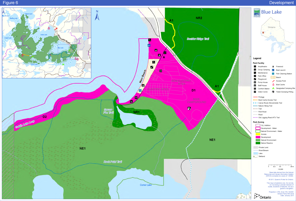
Recreation management provides a variety of recreational opportunities while aspiring to minimize negative environmental impacts. Recreational activities (Figure 6) that are incompatible with the park goal or with specific zones are prohibited or restricted. Prevention and control of such activities will be achieved through enforcement, compliance and education of park visitors concerning appropriate activities in the park in general and within specific zones.
8.2.1 Day-Use Area
Day-users visiting Blue Lake Provincial Park are families and groups from the Dryden and Kenora areas who participate in picnicking, relaxing, walking on the beach, swimming or wading. The 800-metre long beach is the park’s most outstanding and accessible natural attraction. The park’s day-use facilities (picnic shelter, potable water, playground equipment, boat launch, canoe and kayak rentals, and washrooms) are concentrated close to this natural feature. Parking and a fish-cleaning hut are also provided in the day-use area.
Winter day-use for Blue Lake Provincial Park is minimal, consisting of ice fishing, some use of motorized snow vehicles and cross-country skiing. Winter day-use is primarily local in origin.
8.2.2 Campgrounds
Blue Lake Provincial Park provides car-camping at 198 sites, 104 with electricity, from mid-May to the third week of September. Approximately one third of the sites are pull-through for trailers and recreational vehicles. Blue Lake Provincial Park has two group camping sites. The first is an electrical site that has vault privies, a fire pit, and picnic tables on site, potable water nearby and can accommodate 20 to 40 people. The second, newer site is at the southern end of the beach. This site can accommodate 50 to 300 people and provides vault privies, a fire pit, picnic tables and potable water.
Additional campground amenities include vault privies, potable water, trailer service facilities and a comfort station with shower and laundry facilities.
The comfort station (showers and flush toilets), amphitheatre, visitor centre and the Spruce Fen Trail are all barrier-free facilities.
Figure 6: Development Map
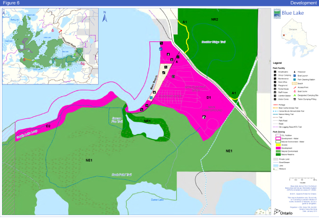
Enlarge Figure 6: Development Map
All campgrounds and campsites will be monitored to ensure their continued viability. This will include necessary improvements to bring them to Ontario Parks' operating standards.
The campground (D1) at Blue Lake Provincial Park may be expanded by as many as 50 sites, with associated infrastructure, when the demand for such facilities becomes evident.
8.2.3 Commercial Services
Blue Lake Provincial Park is located in the Sunset Country Travel Area, which spans northwestern Ontario from Fort Frances to Upsala and north to Red Lake and Pickle Lake.
The provision of private commercial tourism operations such as food and beverage services, recreation equipment rental/sales and retail sales will be determined through business planning, in conjunction with the Northwest Zone Office and park marketing plan.
8.2.4 Roofed Accommodation
The staff house may be rented in the off-season to visitors.
Ontario Parks will consider developing roofed accommodations at the southern end of the campground area (D1) or in the D2 zone along the shore of Blue Lake. These structures will be partially isolated from both the campground and the lake, in a mature jack pine forest. The development of these accommodations will be preceded by an evaluation, (including study of the type, number and location of the accommodations, impacts on other recreational and environmental values, profitability, staff resources, water source, waste disposal, access, and maintenance) in accordance with the requirements of the Class EA-PPCR.
8.2.5 Trails
There are four trails accessible from the Blue Lake Provincial Park campground (Figures 4 and 6): the Boulder Ridge Hiking Trail (1.0 kilometre), the Rock Point Hiking Trail (4.0 kilometres), and the Spruce Fen Interpretive Trail (1.0 kilometre). There is a well-established 4 kilometre long hiking trail in the addition referred to as the Goblin Lake Loop. Refer to section 10.4 for development of new trails.
Two motorized snow vehicle trails intersect the original park boundary via access zone 1 and the addition boundary via natural environment zone 2. Motorized snow vehicle access to park lakes (wholly enclosed) is via NE zones.
There is an ATV trail located within the addition that provides access to Brownie Lake.
8.2.6 Internal Roads and Parking Areas
Ontario Parks may develop new roads, bridges and parking areas. The construction of new roads, bridges and parking areas for park purposes, will be directed by approved implementation and site plans. Such projects will be permitted in the development zones only. Construction will be closely monitored. No development will be carried out prior to approved site plans.
8.2.7 Backcountry Travel
Backcountry/interior camping is not permitted within the original Blue Lake Provincial Park. Interior camping in the Blue Lake Provincial Park addition occurs in association with canoe route #12 Blue Lake Loop, which begins and ends at Blue Lake. Canoeists use shoreline campsites on Indian, Edward, Corner and Whitney lakes.
Ontario Parks will monitor the recreational use of the campsites on these lakes and may provide a minimal level of development (designated sites, pit privies, fire pits) to mitigate impacts of the use of the shoreline for camping and shore lunches. Ontario Parks will consider the implementation of a can and bottle ban if necessary. Users of the shoreline campsites will be required to purchase day-use or camping permits as per regulation under the PPCRA O. Reg. 347/07, s. 15 (1).
8.2.8 Mechanized Travel
Recreational motorized vehicle use including ATVs and motorized snow vehicles, on park hiking/interpretive trails is prohibited.
ATVs are permitted on the trails (old logging roads) in the NE2 zone of the addition and motorized snow vehicles are permitted on the OFSC trail in the original park (A1 zone) and in the addition (NE2 zone). No expansion of these trails will be considered. Refer to section 8.2.5.
Motorized snow vehicles are also permitted to access park lakes (wholly enclosed) for ice fishing via NE zones.
Mountain bikes are permitted on campground roads only and on ATV trails (old logging roads) in the NE2 zone; they are not permitted on the park hiking/interpretive trails. Refer to section 8.2.5.
8.2.9 Rock Climbing
In recent years, an area on the northwest shore of Blue Lake adjacent to the popular Diving Rocks site has been developed for rock climbing by local climbers. The area known as the Blue Lake Crag can be assessed via boat from Blue Lake Provincial Park or from a 1 kilometre walking/bike trail that joins Hwy 647. The Blue Lake Crag consists of five climbing areas with a total of thirty-one bolted climbing routes.
In 2008, a life science inventory of the site was undertaken by Ontario Parks staff to assess any threats to earth and life science features posed by the activity. Based upon this inventory work and cooperation with local climbers and park staff, existing rock climbing activity at this site will be permitted to continue, subject to the conditions listed below and in Appendix II.
Climbers are required to sign an Individual Waiver of Public Liability. Park day-use fees apply to climbers. The Park Superintendent will ensure that rock climbers comply with park policy (e.g. High Risk Activities by Organized Groups in Provincial Parks).
8.3 Partnerships
In the implementation of the approved park management plan, Ontario Parks may pursue opportunities for partnerships involving other agencies and groups through formal partnership agreements.
Partners may represent the local community, and local and provincial interests. Partners will work with Ontario Parks to assist with the implementation of the approved park management plan and follow provincial park policies and regulations.
9.0 Marketing And Communications
9.1 Marketing
Blue Lake Provincial Park will be marketed and promoted in accordance with the Ontario Parks Marketing Plan and established Ontario Parks policy.
9.2 Communications
Blue Lake Provincial Park uses the standard public information program (e.g. Parks Guide, park leaflet, park tabloid, park maps and the Ontario Parks website). This public information program will be continued.
10.0 Development Policies
All development undertaken by Ontario Parks, or by partners on its behalf, will comply with the Class EA-PPCR and will be carried out in accordance with approved site and development plans that meet development standards for provincial parks.
Areas proposed for development will require prior assessment for significant cultural heritage features and natural values-such as species at risk - to ensure these values are identified and protected at the site. Replacement and / or upgrading of park facilities will occur as required.
10.1 Campground
The campground at Blue Lake Provincial Park may be expanded by as many as 50 sites, with associated infrastructure, when the demand for such facilities becomes evident.
Roofed accommodation may be developed at the southern end of the campground area (D1) or in the D2 zone along the shore of Blue Lake.
Ontario Parks will assess the viability of existing comfort stations. The comfort stations will be upgraded and/or replaced as required, including the cost-effective development of additional comfort stations.
10.2 Roads and Utility Corridors
Ontario Parks may develop new roads, bridges and utility corridors. The construction of new roads, bridges and utility corridors for park purposes, will be directed by approved implementation and site plans. Such projects will be permitted in the development zones only. Construction will be closely monitored. No development will be carried out prior to detailed archaeological assessments and approved site plans.
10.3 Day-Use Area
Ontario Parks will continue to monitor the quality of the day-use area. Development in the day-use area will focus on:
- Re-design and re-development to improve quality and operational effectiveness; and,
- A limited amount of new development to provide additional day-use opportunities (i.e. picnic shelters).
Where user conflicts or operational inefficiencies exist, separation of day-use and camper activity will be undertaken.
10.4 Trails
- Ontario Parks may develop new trails. The construction of new trails in the development, natural environment and nature reserve zones will be subject to approved site plans. A Park Trail Plan / Strategy will be developed.
10.5 Maintenance and Administrative Areas
The park staff accommodations, warehouse, office and gatehouse will be upgraded or replaced as required.
10.6 Activity Centre
The park activity centre will be replaced as required with a facility that meets Ontario Parks standards for seasonal activity parks.
11.0 Implementation Priorities
Park development, operations and resource stewardship will be contingent upon the availability of funding and unforeseeable changes in priorities or policy. Implementation of the management plan and operation of the park will meet the requirements of the EAA, EBR, PPCRA, ESA, 2007 and other pertinent legislation.
All aspects of park management, development and operation will be undertaken in accordance with the requirements of the Class EA-PPCR.
Park development proposals will be phased in as follows:
11.1 Stage One
- Removal BMAs in nature reserve zones from the BMA in regulation.
- Establish in regulation under the appropriate legislation, prohibition of the use or possession, of live bait fish within waterbodies wholly contained within the park.
- Amend existing regulations under PPCR Act to institute a ban on non burnable food and beverage containers for back country users as more fully described in section 8.2.7.
- Amendment and update of the Vegetation Management Plan to explore ways to manage fire, and to maintain the biodiversity and ecological integrity of the park, while balancing this with the needs of the park users.
- Replacement and / or upgrading of park facilities as required.
- Preparation of a NHE Plan.
- Preparation of a Park Trail Plan / Strategy.
- Annual review of the operating plan, the business plan and the NHE Plan.
11.2 Stage Two
- Archaeological assessment.
- Inventory of interior campsites.
- Rustic cabins.
- Campground expansion.
12.0 Summary of Aboriginal Involvement and Public and Stakeholder Involvement
Public involvement was a very important part of the Blue Lake Provincial Park management planning process.
Phase 1 - Invitation to Participate; Terms of Reference, December 17, 2003 - January 31, 2004
The invitation to participate and to review the approved terms of reference stage included newspaper advertisements, distribution to the mandatory contact list as well as to Aboriginal communities and known stakeholders, posting the EBR electronic registry proposal notice, distribution to park, zone and district offices, and the Ministry of Natural Resources Information Centre in Peterborough.
Two written comments were received at the northwest zone office from December 17 to January 31. The comment from Bowater Forest Products Division addressed the role of parks in meeting landscape level objectives in forest management and the need to keep the park’s Forest Resource Inventory (FRI) up to date. The comment from the Ontario Federation of All Terrain Vehicles (OFATV) addressed the traditional use of area trails by ATVs and the need to have trail use overseen by a provincial body, so that riders are restricted to an approved, insured, signed and wardened trail system.
Phase 2 - Preliminary Management Plan, June 21, 2010 - August 05, 2010
This phase included newspaper advertisements, and distribution of a notification letter, regarding the release of the preliminary park management plan, to the mandatory contact list and to known stakeholders, as well as an update to the EBR notice listed above. The document was also available on the Ontario Parks' website. No written comments were received.
Phase 3 - Approved Park Management Plan August 20 – October 4, 2012
In Phase 3, a policy decision notice associated with the approved park management plan was posted on the EBR and a paid advertisement was inserted in local and regional newspapers. A notification letter was mailed to local Aboriginal communities, local residents, interest groups and others in August 2012. This allowed interested participants a final 45-day opportunity to determine if their concerns had been adequately considered and addressed, and to initiate an appeal of the plan contents where appropriate.
Ontario Parks will retain on file reference copies of the terms of reference, preliminary management plan and the approved park management plan.
13.0 Plan Re-write, Amendment and Examination
The park management plan can be re-written or amended to address changing issues or conditions. At ten year intervals, this plan will be examined for the need for a re-write or amendment.
A re-write may involve a reassessment of all or part of the plan, including classification, zoning, goal, objectives and all resource management, operations and development policies.
14.0 References
Dunster, J. and K. 1996. Dictionary of Natural Resource Management, UBC Press. Vancouver, British Columbia.
Kor, P. 1974. Geomorphology and Geology of Blue Lake Provincial Park, Northwestern Region, Kenora. OMNR
Kor, P. 1977a. Earth Science Inventory Checklist: Blue lake Provincial Park – Precambrian terrain. Unpublished
Kor, P. 1977b. Earth Science Inventory Checklist: Blue Lake Provincial Park – Clay plain. Unpublished.
Kor, P. 1977c. Earth Science Inventory Checklist: Blue Lake Provincial Park. OMNR.
Kor, P. 1977d. Earth Science Inventory Checklist: Blue Lake Provincial Park – Eagle-Finlayson Moraine. Unpublished
Noble, T. 1977. Ontario Nature Reserves Program –Life Science Inventory Check-Sheet Blue Lake Provincial Park – Bog. Unpublished.
Noble, T. 1977. Ontario Nature Reserves Program – Life Science Inventory Check-Sheet Blue Lake Provincial Park – Jack
North-South Environmental Inc. 2001. Earth Science and Life Science Reconnaissance Surveys 14 Provincial Parks and Conservation reserves In the Western park of Northwestern Ontario: Summary Representation to the Earth and Life Science Checksheets. Unpublished.
North-South Environmental Inc. 2000, Summary Report of the Reconnaissance Surveys. Field study undertaken October 4, 2000.
[OMNR] Ontario Ministry of Natural Resources. 1979. Regional Park Systems Plan – Phase 1 Northwest Region. Unpublished. Ontario.
[OMNR] Ontario Ministry of Natural Resources. 1980. Ontario Provincial Parks Landscape Design Principles and Guidelines. Parks and Recreational Areas Branch Outdoor Recreation Group. Ontario.
[OMNR] Ontario Ministry of Natural Resources. 1984. Planting Plan for Blue Lake Provincial Park. Unpublished. Ontario.
[OMNR] Ontario Ministry of Natural Resources. 1987. Dryden District Fisheries Management Plan 1987-2000 Draft.
[OMNR] Ontario Ministry of Natural Resources. 1989. Blue Lake Provincial Park Background Information. Queen’s Printer for Ontario.
[OMNR] Ontario Ministry of Natural Resources. 1991. Blue Lake Provincial Park Management Plan. Queen’s Printer for Ontario.
[OMNR] Ontario Ministry of Natural Resources. 1992. Ontario Provincial Parks Planning and Management Polices. Ontario.
[OMNR] Ontario Ministry of Natural Resources. 1999. Ontario’s Living Legacy Land Use Strategy. Queen’s Printer for Ontario. Toronto.
[OMNR] Ontario Ministry of Natural Resources. 2000. Blue Lake Provincial Park Expansion Fact Sheet.
[OMNR] Ontario Ministry of Natural Resources. 2001. Blue Lake Provincial Park Addition (P2347) Recreation Resource Assessment Inventory Report.
[OMNR] Ontario Ministry of Natural Resources. 2005.
[OMNR] Ontario Ministry of Natural Resources. 2006. A Technical Guideline for Cultural Heritage Resources for Projects Planned Under the Class Environmental Assessment for MNR Resource Stewardship and Facility Development Projects and the Class Environmental Assessment for Provincial Parks and Conservation Reserves.
Ontario Parks. n.d. Ontario Parks Strategy for Roofed Accommodation phase 1.
Ontario Parks. 1997. Vegetation Management Plan for Blue Lake Provincial Park.
Ontario Parks. 2002. Park Statistics.
Ontario Parks. 2003. Park Statistics.
Ontario Parks. 2005. Park User Survey 2005.
Ontario Parks. 2008. Park User Survey 2008.
Thacker, B. 1974, Ecological Inventory of Blue Lake Provincial Park. Park Planning Branch, Ministry of Natural Resources
Thurston, P.C. 1991. Archean Geology of Ontario: Introduction; in Geology of Ontario, Ontario Geological Survey, Special Volume 4, Part 1.
UCMP 2003 Glossary of Natural History Terms Volume 5 Ecological terms. http://www.ucmp.berkeley.edu/glossary/glossary.html
Van Sleeuwen, M. 2006. Natural Fire Regimes in Ontario. Ontario Ministry of Natural Resources, Queen’s Printer for Ontario, Toronto. 143 pp.
Van Wagoner, D. 2000. Tourism: trends and opportunities in the North of Superior Region. Ministry of Northern Development and Mines.
Zoltai, S.C. 1961. Glacial history of part of northwestern Ontario. Proc. Geol. Assoc. Canada, vol. 13.
Appendix I Scientific Names of Plants and Animals Referenced in the Document
Plants:
balsam fir (Abies balsamea)
black ash (Fraxinus nigra)
carnivorous sundew (Drosera rotundifolia)
cattail (Typha latifolia)
crested wood fern (Dryopteris cristata)
eastern white cedar (Thuja occidentalis)
hairy willow herb (Epiloblium ciliatum)
leather-leaf (Chamaedaphne calyculata)
lesser pyrola (Pyrola minor)
long beech fern (Phegopteris connectilis)
nodding trillium (Trillium cernuum)
northern bugleweed (Lycopus uniflorus)
oak fern (Gymnocarpium dryopteris)
pitcher plant (Sarracenia purpurea)
red maple (Acer rubrum)
red pine (Pinus resinosa)
reed canary grass (Phalaris arundinacea)
rough cotton-grass (Eriophorum tenellum)
speckled alder (Alnus incana)
spinulose wood fern (Dryopteris carthusiana)
stair-step moss (Hylocomium splendens)
sweet coltsfoot (Petasites palmatus)
sweet gale (Myrica gale)
wild ginger (Asarum canadense)
white pine (Pinus strobus)
white spruce (Picea glauca)
Mammals:
American marten (Martes americana)
beaver (Castor canadensis)
black bear (Ursus americanus)
lynx (Lynx canadensis)
moose (Alces alces)
red fox (Vulpes vulpes)
river otter (Lutra canadensis)
snowshoe hare (Lepus americanus)
timber wolf (Canis lupus)
white-tailed deer (Odocoileus virginianus)
Amphibians:
American toad (Bufo americanus)
boreal chorus frog (Pseudacris maculata)
leopard frog (Rana pipiens)
spring peeper (Pseudacris crucifer)
Reptiles:
eastern garter snake (Thamnophis sirtalis sirtalis)
western painted turtle (Chrysemys picta bellii)
Fish:
walleye (Sander vitreum vitreum)
lake trout (Salvelinus namaycush)
Appendix II
Rock Climbing At Blue Lake Provincial Park
- No new route activity.
- No new fixed protection. Permission from the Park Superintendent must be sought before replacing fixed protection.
- Do not use trees in any way, shape or form (even slinging them) for belays and rappels.
- Rappelling may only be done on designated routes equipped with rappel anchors. Climb only established routes.
- Do not leave any gear behind. If you must leave anything for emergency purposes, retrieve it as soon as possible, or notify park staff.
- Climbing waivers are required. They are available at the Blue Lake Provincial Park office or the Ministry of Natural Resources-Ontario Parks building 479 Government Rd Dryden, ON 2nd floor.
807-223-7535 - Access to the climbs is a bottom access only area, via Blue Lake Provincial Park (boat) or footpath, from Hwy 647. ATVs are strictly prohibited.
- This is a leave no trace area. Pack out what you bring in.
- No camping on site.
- No open fires.
- Notify park of any hazards (rock fall, loose bolts etc.)
Footnotes
- footnote[1] Back to paragraph A rhythmite is a sedimentary structure of rhythmically paired laminations or beds. The flat-lying, fine-grained bottomset beds of many large former glacial lakes filled in and buried all of the pre-existing relief and are now exposed, forming perfectly flat lake plains. Cuts into these sediments often reveal rhythmically interbedded silts and clays. Some of these so-called rhythmites have been shown to be the result of seasonal changes in the proglacial environment. If such lacustrine deposits have annual silt and clay ‘couplets', they are known as varves (Kipfer 2003).
- footnote[2] Back to paragraph 2. (1) No person shall, (b) damage or deface any relic, artifact or natural object or damage or deface any site of archaeological or historical interest in a provincial park. O. Reg. 347/07, s. 2 (1).