Cache Bay Wetland Conservation Reserve Management Statement
This document provides policy direction for the protection, development and management of the Cache Bay Wetland Conservation Reserve and its resources.
Statement of Conservation Interest
Ontario Ministry of Natural Resources and Forestry
North Bay District
2003
Approval statement
We are pleased to approve this Statement of Conservation Interest for the Cache Bay Wetland Conservation Reserve (C171).
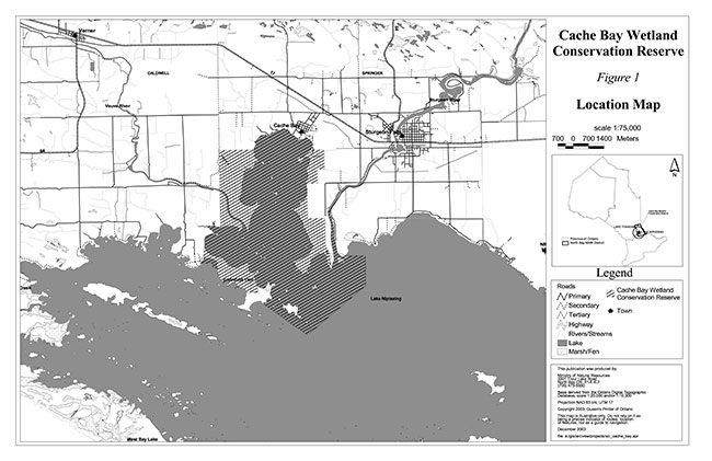
Cache Bay Wetland Conservation Reserve is a 3,926 hectare parcel of Crown land, located on the north shore of Lake Nipissing. The conservation reserve is located in Ecodistrict 5E-5 south of the village of Cache Bay. The area exhibits a wide range of habitat including swamp, marsh and fen. This diverse environment serves as an excellent breeding and staging ground for a variety of waterfowl. As well, it provides an exceptional spawning and nursery environment for the fisheries of Lake Nipissing.
Cache Bay Wetland Conservation Reserve is one of 378 protected areas approved through Ontario’s Living Legacy, a land use strategy aimed, in part, at completing Ontario’s system of parks and protected areas. The site was originally regulated under the Public Lands Act and then subsequently regulated under the Provincial Parks and Conservation Reserves Act (PPCRA) when the act came into effect in 2006.
During the Lands for Life planning process the public was widely consulted and provided valuable input into what became Ontario’s Living Legacy. Comments received during that time, and during consultation related to the formal Public Lands Act regulation of the boundaries of this conservation reserve were generally supportive of the protection of this area.
Stakeholders who expressed an interest in the planning of this site were notified regarding the draft SCI and given a one month review period. A letter was also sent to boathouse land use permit holders. Any comments, including input from previous consultation, were considered in the finalization of this document. There was limited interest expressed by the public during the review of the draft SCI. No new issues have been identified; however significant historical background information was obtained and incorporated into the SCI. This document was also reviewed by MNRF staff.
This SCI provides guidance for the management of the conservation reserve and the basis of the ongoing monitoring of activities. More detailed direction is not anticipated at this time. Should significant facility development be considered or complex issues arise requiring additional studies, more defined management direction or special protection measures, a more detailed Resource Management Plan will be prepared with full public consultation.
Cache Bay Wetland Conservation Reserve is managed under the direction of the North Bay District Manager and Resource Operations Supervisor.
Prepared by:
Klara Vodicka
OLL Planning Intern
December 15, 2003
Original signed by
Dave Payne
District Manager
North Bay District
Date: December 19, 2003
Rob Galloway
Regional Director
Northeast Region
Date: January 9, 2004
Administrative update
Approved by:
Mitch Baldwin
North Bay District Manager
Date: July 21, 2017
Corrinne Nelson
Northeast Regional Director
Date: July 24, 2017
1.0 Introduction
The following document is a Statement of Conservation (SCI) for Cache Bay Wetland Conservation Reserve (C171). The purpose of this SCI is to identify and describe the natural, recreational and cultural values of Cache Bay Wetland Conservation Reserve and to outline the Ministry of Natural Resources and Forestry’s (MNRF) management intent for this area. The first portion of this document highlights the provincial context in which it was produced, states its goal and objectives, and summarizes the planning process for conservation reserves. The remainder of this document specifically addresses Cache Bay Wetland Conservation Reserve. Management direction provided within this SCI will serve to protect the conservation reserve for the benefit of all Ontario residents. This direction will comply with the land use intent stated in the Ontario’s Living Legacy Land Use Strategy (OMNR 1999) and the Provincial Parks and Conservation Reserves Act (PPCRA) (Statutes of Ontario 2006).
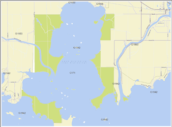
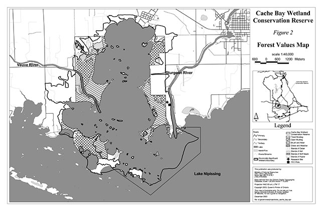
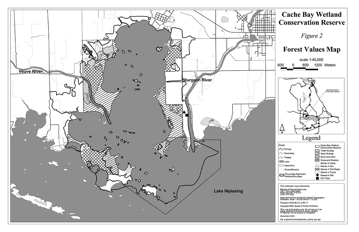
Cache Bay Wetland Conservation Reserve is located on the north shore of Lake Nipissing approximately 5 km southwest of Sturgeon Falls near the town of Cache Bay. The boundary of the conservation reserve is located in the geographic townships of Springer and Caldwell within the Municipality of West Nipissing (Figure 1). The conservation reserve encompasses the southern portions of the Veuve and Sturgeon River. The area consists of a combination of swamp, marsh, and fen, with some bog areas occupying microsites within the fen (Figure 2). The adjacent shoreline, lakebed and Crown islands are included within the conservation reserve.
Direction for establishing, planning and managing conservation reserves is defined under the Provincial Parks and Conservation Reserves Act (PPCRA) and associated regulations and guidelines. The direction for managing this conservation reserve is in the form of a SCI, which defines the area that is being planned, provides the purpose for which the conservation reserve has been proposed, and outlines the Ministry of Natural Resources and Forestry’s (MNRF) intent for the protected area. This SCI will provide both guidance for the management of the conservation reserve and the basis for ongoing monitoring of activities. More detailed direction at this time is not anticipated; however, should significant facility development be considered or complex issues arise requiring additional studies, more detailed management direction will be prepared with full public consultation.
Public and Aboriginal consultation occurred prior to the regulation of this conservation reserve during the planning for Ontario’s Living Legacy. Furthermore, there was a 15-day review period in November 2002 concerning a draft of this SCI. Comments from the review period have been considered in the development of this document.
Cache Bay Wetland Conservation Reserve was originally established by Ontario Regulation 313/02, under authority of the Public Lands Act (O. Reg. 805/94) on December 7, 2002. The CR was subsequently regulated under O. Reg. 317/07 when the PPCRA came into effect in 2006. The planning area for this SCI is the regulated boundary of the conservation reserve.
This SCI will be implemented by the North Bay District Manager and the Resource Operations Supervisor, and will be examined, updated or amended as per the PPRCA and associated guidleines.
1.1 Planning context
Ontario’s Living Legacy Land Use Strategy was approved in 1999. The objectives of the Land Use Strategy are to complete Ontario’s system of protected areas; recognize the land use needs of resource-based tourism industry; provide forestry, mining and resource industries with greater certainty around land and resource use; and enhance hunting, angling and other Crown land recreational opportunities. Cache Bay Wetland Conservation Reserve was created as part of the expansion of protected areas.
Conservation reserves protect natural heritage values on public lands, while permitting compatible land use activities. By allocating these lands to the parks and protected areas system through regulation, the province has ensured a certain level of permanence by distinguishing the conservation reserve and its values from the larger general use or more extensively managed landscape. In addition, the conservation reserve’s natural features are, and will be available for present and future generations to enjoy and explore.
The MNRF has established conservation reserves as a tool to protect natural heritage areas on public lands, while permitting traditional public land uses to continue. These uses include recreation activities, such as hunting and fishing, and the traditional activities of Aboriginal societies, as defined under applicable Aboriginal Treaties. Lands regulated as conservation reserves under the PPRCA (Statutes of Ontario 2006) are removed from the Sustainable Forest Licence, and mining and surface rights are withdrawn from staking under the Mining Act (RSO 1990 Chapter M.14).
Ontario’s Living Legacy Land Use Strategy (1999) and the PPRCA (Statutes of Ontario 2006) and associated regulations outline the general land use policy and management direction for new conservation reserves; however, each conservation reserve has a planning document, such as this SCI, which details site-specific management direction.
Comments received during the Lands for Life process, and during consultation related to the formal regulation of the boundaries of this site were generally supportive of the establishment of this area as a conservation reserve. Stakeholders who expressed an interest in the planning were notified regarding the draft SCI and given a one month review period where the draft was made available. Letters were also sent to boathouse land use permit holders. Any comments, including input from previous consultation, were considered in the finalization of this document. There was limited interest expressed by the public during the review of the draft SCI. This SCI was also reviewed by MNRF staff.
Although more detailed direction is not anticipated at this time, should significant facility development be considered or complex issues arise, requiring additional studies, more defined management direction or special protection measures, a more detailed Resource Management Plan will be prepared with full public consultation.
1.2 Background information
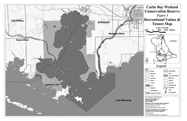
Cache Bay Wetland Conservation Reserve is one of Lake Nipissing’s largest wetlands. It is located approximately 5 km southwest of Sturgeon Falls on the north shore of Lake Nipissing south of the community of Cache Bay (Figure 1). The site encompasses a provincially significant wetland (Figure 2) which provides crucial habitat for a variety of wildlife such as various duck and fish species. The site also provides many recreational opportunities including sport fishing, hunting and cranberry picking. Access includes, but is not limited to, boat in the summer, snowmobile trail in the winter or by a trail system located along the eastern boundary of the site near the Sturgeon River House Museum (Figure 3).
The following chart summarizes administrative information for Cache Bay Wetland Conservation Reserve:
| Name and OLL ID number | Cache Bay Wetland Conservation Reserve (C171) |
|---|---|
| Ecoregion/Ecodistrict (Hills, 1959; Crins, 2000) | 5E (Georgian Bay), 5E-5 (North Bay) |
| OMNR Administrative Region/District/Area | Northeast Region/North Bay District/ Tomiko Area |
| Total area (ha) | 3,926 |
| Regulation date |
Originally regulated on December 7, 2002 (O. Reg. 805/94) under the Public Lands Act Subsequently regulated under the PPRCA when it came into effect in 2006 under O. Reg. 317/07. |
| Township(s) | Springer, Caldwell |
| First Nations | Nipissing First Nation - area of interest - through the Robinson Huron Treaty Dokis First Nation - area in which they may have interest (important native sites within the conservation reserve) |
| OBM map sheets | 2017 5700 51200 – 2017 5700 51300 |
| Topographic map name/Number | Verner 41 I/8 and Sturgeon Falls 31 L/5 |
| UTM coordinates | 576,700 m E 5,131,000 m N |
| General location, description, access | Approximately 5 km southwest of Sturgeon Falls on the north shore of Lake Nipissing. Site contains mixed wetland habitat including swamp, marsh and fen. Access is provided via trails that originate from the Sturgeon River House Museum on the east side of the wetland, by boat or by snowmobile trail. |
1.3 Historical context
Cache Bay has historically served as a logging and lumber town. Barnette and Mackie were the first logging operators in Cache Bay in the 1830's. Cockburn Lumber Company was eventually built in 1896 on the west side of the area now known as Cache Bay Trailer Park. This mill processed lumber from logging operations located along the Veuve River (LeBelle, 1998).
John Rudolphus Booth, a lumber baron, also operated in the area. Many of Booths lumberjacks cut centuries old trees and virgin pine forests that surrounded Lake Nipissing and the Sturgeon River. The logs were towed by steamboat to Callander, shipped by train to Mattawa and then sent down the Ottawa River to his saw mill near Ottawa. Mr. Booth bought up large tracts of land surrounding Cache Bay. Much of this land was sold to employees of the mill, and now makes up much of the private land that surrounds the conservation reserve today (LeBelle, 1998).
Twenty acres of shoreline was also sold to Davidson and Hay, a firm that set up a saw mill. This mill was taken over by Geo. Gordon Company, a company formed by Robert Booth and Robert Gordon, in July of 1901 after financial hardships incurred by a fire. This new company eventually bought up all of the property south of the railway along with Barnette and Mackie’s original mill now owned by Nipissing Lumber Company. Gordon’s lumber yards were considered one of the best locations for drying pine lumber in the province because of the prevailing southwesterly winds that cross the bay. The town grew and by 1905 there were 178 buildings located in and around Cache Bay (LeBelle, 1998).
Following the Great Depression, the Geo. Gordon Lumber Company ran their saw mill and planer operation night and day to meet the existing demand. Many of the wood shavings that were normally burned in the operation had to be disposed of in Cache Bay, because of the limited capacity of the boiler room. These shavings rotted and helped produce some of the nutrient rich areas that are vegetated today (LeBelle, 1998). Further nutrient inputs were achieved by agricultural use and the emptying of outhouse boxes into the Cache Bay. Fortunately the emptying of human waste directly into the Bay was abandoned for environmental and health reasons.
The Geo. Gordon Lumber Company continued to thrive into the 20th century. New structures were added and deteriorating and less modern facilities were rebuilt. Various fires also prompted the rebuilding effort as the mill burned on various occasions. This continued until operations ceased in 1965 (LeBelle, 1998).
Since this time there have not been any commercial tree cutting operations in that area. The area surrounding Cache Bay Wetland Conservation Reserve still continues to be used by local residents, farmers, hunt camp and cottage owners.
1.4 Goals
The goal of the Cache Bay Conservation Reserve is to identify and describe the natural and cultural heritage values on public lands while permitting compatible land use activities and to to provide the framework and direction to guide management decisions affecting the Cache Bay Wetland Conservation Reserve.
1.5 Objectives
The following objectives are identified as a means to achieve the above-stated goals.
- To describe the state of the resource with respect to natural heritage values and current land use activities.
- To manage the conservation reserve to protect the integrity of its natural values via specific guidelines, strategies and prescriptions.
- To meet planning requirements by addressing the management intent of the conservation reserve and addressing planning and management needs.
- To create a public awareness of the values within the conservation reserve and promote responsible stewardship of the protected area through partnerships with local stakeholders.
- To determine long-term management goals of the conservation reserve by identifying research, client services and marketing strategies.
- To identify scientific values on the site in relation to provincial benchmarks and identify the necessary monitoring and/or research to maintain the integrity of those values.
- To work with the municipality to protect private land portions of the wetland and adjacent lands.
1.6 Representation
The following sections provide a summary of the life science, earth science and cultural heritage values, as well as recreational opportunities.
Life science representation:
This conservation reserve, which encompasses a provincially significant wetland as evaluated by the Northern Wetland Evaluation System in 1993, contains 36 vegetation communities lying on clay/loam base above a humic/mesic layer. The upland portions of the conservation reserve contain 9 hardwood and mixedwood communities (Burkhardt et al., 2003).
The following landform types and vegetation associations are found:
- Lacustrine wetland is composed mainly of swamp and marsh with some fen vegetation
- Dominant vegetation includes deciduous trees, robust emergents and submerged plants.
- Less dominant vegetation includes tall shrubs, low shrubs and narrow-leaved emergents.
- Hardwood and mixedwood forest stands contain species such as red maple, poplar and black ash
- Many transitional zones are present within the conservation reserve and between Crown and patent land.
- Cranberry bog dominated by flat plain peatland and the large cranberry
- Topography flat/rolling
- Hydrologically connected to other wetland types, rivers and open water
- Catchment soil coverage thin and permeability moderate
- Temporal flooding can occur in low lying areas
- Wetland pH high, very basic
- Fish habitat present in low marsh and high marsh areas that are seasonally and permanently flooded
- Important spawning and nursery habitat for Lake Nipissing’s sport fish populations
- Important waterfowl staging and breeding ground
- Endangered species, species of provincial, regional and special significance present
Earth science representation:
Cache Bay Wetland Conservation Reserve is composed of bedrock drift complex and is part of the Grenville Province of the Canadian Shield. The bedrock is composed of an igneous granitic base of granite, granitic hornblend and biotite gneiss. Weakly broken lacustrine fine textured sand, silt and clay/loam with a mesic/humic layer make up the soil horizons. The area is at least of regional significance because it encompasses portions of two deltaic systems with distinct morphological differences including a tombolo on the southwest side (Kristjansson, 2003).
Cultural heritage values:
Cache Bay Wetland Conservation Reserve was identified as having high potential heritage areas and sites. A known cultural heritage trail runs along the Sturgeon River further enhancing the cultural value of the site. More in-depth research concerning cultural heritage values has not been completed to date.
Recreational opportunities:
The site offers a variety of recreational opportunities including; hunting, sport fishing, boating, bird watching, walking, wildlife viewing, berry picking, snowmobiling and camping. The site is commonly accessed by boat in the summer, snowmobile in the winter or by the Sturgeon River House Trail system located on the eastern shore of the wetland (Tremblay, 2002).
1.7 Survey work
The following table provides an overview of inventories completed, their level of detail, and any further inventories that are required.
| Survey level | Life Science | Earth Science | Cultural | Recreational |
|---|---|---|---|---|
| Reconnaissance | Burkhardt, B. et al., 2003, Life Science Checksheet Aerial Survey Noble, 1991, Life Science Checksheet for Cache Bay Cranberry Bog | Kristjansson, F.J.,2003, Earth Science Checksheet, Aerial Survey | First Nations Interviews, 1998 & 2003, Native Background Information Report and Values Maps, related to Forest Management Planning | Tremblay, D., 2002, Recreational Inventory Checklist, Aerial and Ground Survey |
| Detailed | Meil, Wayne, 1993, Wetland Evaluation for Cache Bay, Ground survey | None | None | None |
| Requirement | None | None | None | Monitor on on-going basis |
2.0 State of the resource
The conservation reserve is located entirely within Ecodistrict 5E-5 (Crins, 2000). Values include life science, earth science, cultural and recreational/aesthetic with an emphasis on life science values.
Significance is determined on the basis of the following criteria: representation, diversity, condition, ecological considerations and special features (Crins and Kor, 1998).
Representation:
There are six vegetation forms that dominate Cache Bay Wetland Conservation Reserve; these include submerged plants, robust emergents, deciduous trees, tall shrubs, low shrubs and narrow-leaved emergents. There are 36 wetland communities present within the conservation reserve. The inner-most portions of the wetland include a variety of marsh species. Robust and narrow-leaved emergents include bulrushes, cattails, reed grass bluejoint and wild rice. Submergents, floating and free floating plants include waterweeds, water-milfoils, pondweeds and duckweed. A few water-tolerant tree and shrub species also inhabit the area. The outer areas contain a mixture of swamp and fen communities. The swamp communities include various tree species such as trembling aspen, black ash, silver maple, eastern white cedar and various willow species. Tall and low shrub species are present in the swamp. They include northern wild raisin, speckled alder, winterberry and sweet gale. Narrow-leaved emergents such as carex and various grasses along with herb species occur in these areas as well. The fen portions of the wetland are not as numerous as the swamp and marsh areas, though they are represented. Fens are considered to be rare and thus deserve the added protection of a conservation reserve. The fen vegetation is mostly comprised of low shrubs such as sweet gale, leatherleaf and cranberry. Other species such as ferns, grasses and mosses are present as well. The upland portions of the conservation reserve contain 9 different forest communities. These communities, which are interspersed throughout the reserve, contain hardwood and mixedwood stands of red maple, poplar and black ash. Included within these small upland areas are candidate stands for old growth.
Diversity:
Diversity is a measure of the conservation reserve’s earth and life science variety. The evaluation is based on the number and range (assortment) of landscape features and landforms for earth science values and the relative richness and evenness of the site’s life science components.
The majority of this site is made up of three wetland types including marsh, swamp and fen (Figure 2). A smaller portion of the site includes hardwood and mixedwood stands of red maple, poplar and black ash. This allows for a mixture of dominant vegetation forms such as deciduous trees, robust emergents and submerged plants as well as less dominant vegetation forms such as tall shrubs, low shrubs and narrow-leaved emergents to thrive. Diversity of the surrounding landscape includes pastures, crop fields, fence rows, cottages/hunt camps, abandoned agricultural land, rock outcrops, deciduous forests and open lake or deep water. There is a great amount of interspersion or edge effect within and at the boundaries of the conservation reserve. This edge effect enhances the biodiversity within the wetland by creating various transitional areas between different habitat types. Many species depend on a variety of habitat types for survival. Open water within the conservation reserve accounts for 26-75% of the central portion of the wetland (Meil, 1993). This design is conducive to the needs of a variety of species leading to a more diverse environment. The proximity of this wetland to Lake Nipissing, the Veuve River and the Sturgeon River produces an ideal spawning and nursery ground for the Lake’s fish population. All of these combined factors make this site rich with biodiversity.
Condition:
Overall the conservation reserve is in fairly good condition despite the high intensity of use that existed in the past. The area has been moderately disturbed as it continues to be utilized by the public both recreationally and commercially. Recreational activities such as fishing, hunting and berry picking and access associated with these activities may disturb shoreline vegetation and wildlife in the area. Other disturbances include a variety of authorized land uses, including baitfishing, trapping, boathouse development, agricultural use and an educational/recreational trail. Past disturbance of the area included commercial forestry operations and the development of surrounding areas including the town of Cache Bay; this may have contributed to the features and functions that exist there today. Some infill development continues along the river. Farmer’s fields, which surround the conservation reserve, contribute to the disturbance found within the site mostly through nutrient rich runoff and possible chemical pesticide use. Any increases in input from nutrient rich runoff could have a detrimental effect on the integrity of the life science values associated with the conservation reserve.
Ecological considerations:
Included within the 3,926 hectare conservation reserve is the lakebed portion of the bay, Crown islands and surrounding Crown shoreline. Sections of the Veuve and Sturgeon River have also been included within the site (Figure 1). Approximately 80% of the Cache Bay is publicly owned through its designation as a conservation reserve, however the area is almost completely surrounded by patent land. The patent land that surrounds the site has led to the vectored boundaries along its east and west sides. Thus, the natural boundaries of site may not be included within the conservation reserve leading to a decreased buffer of the core values that are protected within the site. In addition, adjacent or upstream land uses could impact the site. Some areas have limited buffering capacity to act as a filter for pesticides, excess nutrient input and sedimentation from soil run-off. ATV and boat use could potentially impact the site. The MNRF will strive to develop partnerships with local land owners and the municipality in order to ensure that natural heritage values are protected.
Special features:
There are a variety of unique life science features associated with Cache Bay Wetland Conservation Reserve. The primary vegetative feature is the distinctive habitat that occupies the site. There are three wetland types, which include 36 different wetland communities, and small upland areas which include 9 different forest communities. One particular community, known locally as the Cache Bay Cranberry Bog, provides many recreational opportunities for cranberry picking in the fall. This same area is characterized by a sand beach storm ridge which is covered by a line of overhanging silver maple with the occasional green ash and bur oak. These species, which are of regional significance, can also be found at the western portion of the conservation reserve near the mouth of the Veuve River.
The conservation reserve is known as an important waterfowl staging and breeding ground. The site is a known traditional migration or feeding habitat for at least two endangered species, the white pelican and bald eagle. As well, there is suitable breeding habitat for the black duck a species of special status, osprey and herons. Many provincially significant species have been recorded at the site such as the least bittern, the redhead, the greater scaup and the great black-backed gull. The black tern and caspian tern, which are also considered provincially significant species, have been recorded as nesting at the site. In addition, there are known regionally significant species within the ecodistrict that may inhabit the site. Those species include the American widgeon, the marsh wren, the pintail and the three-toed woodpecker (Meil, 1993). A glossy ibis, whose native range should only extend to Maine, has also been observed within the conservation reserve (Tafel, 2003).
Cache Bay Wetland Conservation Reserve also serves as an important spawning and nursery habitat for Lake Nipissing’s fish population. This crucial habitat helps to replenish Lake Nipissing’s walleye, pike, muskellunge and bass and thus, support recreational fishing opportunities in the area.
2.1 Life Science
Gap analysis is a method of identifying gaps in representation of all landform/vegetation features within the Ecodistrict, and to identify potential sites that best fill those gaps. The objective of gap analysis is to complete representation of all vegetation community and landform types within protected areas (Bergsma, 1995). During the Lands for Life planning exercise, the emphasis for new protected areas was sites identified through gap analysis. Cache Bay Wetland was not identified through gap analysis, but was put forward as a conservation reserve based on life science representation for site region 5E (Noble, 1991).
Cache Bay Wetland Conservation Reserve provides a unique yet highly representative sample of wetland diversity. This lacustrine wetland includes swamp, marsh and fen habitats and a known cranberry bog, which help to provide habitat to a variety of wildlife. The conservation reserve provides important waterfowl staging and breeding grounds for various provincially significant and endangered bird species. Nesting platforms (Photo 2), that support some of these birds, can be found throughout the conservation reserve. The site includes parts of the Veuve and Sturgeon River, which contain important spawning and nursery habitat for Lake Nipissing’s fish population. The area is considered to be in fairly good condition despite the heavy recreational and commercial use.
2.2 Earth Science
Cache Bay Wetland Conservation Reserve is composed of bedrock drift complex and is part of the Grenville Province of the Canadian Shield. This area is made up of broken basinal plain of wave-washed bedrock, weakly broken lacustrine fine textured organic sand, silt and clay flats and a small amount of weakly broken ground moraine near Goulais Point. Much of the northwest, northeast and southwest are underlain by deltaic and/or lacustrine deposits while the northwest contains a fairly extensive area of bedrock outcrop. Deposits of lacustrine sand and gravel can be found in former beach and deltaic areas from previous glacial processes and lakes in the area. The underlying bedrock is made up of acidic granitic igneous rock such as granite, granitic hornblende and biotite gneiss. There are pockets of water-laid silty clay, silt and sand that lie between shallow covered rock ridges in the northwest. The silty clays range in lime content, while the silts contain low amounts of lime. The sands are generally granitic in nature and thus have a low base content. The area is at least of regional significance geologically. It encompasses portions of the two deltaic systems with distinct morphological differences. Interesting geologic features include a tombolo (sand spit) on the southwest side connecting former bedrock islands to the mainland. This site also provides a natural laboratory for investigating the influence of river and wave regime on delta morphology while eliminating factors related to tidal regime. In addition, because the Sturgeon River and Veuve River deltas are in close proximity to each other in the same lake basin, factors such as lake level history and isostatic rebound can be controlled (Kristjansson, 2003).
2.3 Cultural values
There are known and potential cultural values associated with Cache Bay Wetland Conservation Reserve. There is a known cultural heritage site near the conservation reserve as well as a known cultural heritage trail within the conservation reserve. Numerous high potential heritage areas were identified within the site. High potential cultural heritage areas are identified using a computer based predictive modeling program. Based on a series of pre-defined parameters, the program identifies candidate areas, which are most likely to be culturally significant.
2.4 Recreational/Aesthetic values
The conservation reserve offers a wide array of recreational opportunities in close proximity to the towns of Cache Bay and Sturgeon Falls, two population centres. As well, the site is located only 45 km from the City of North Bay making the area a very desirable destination. The recreational opportunities can be accessed by boat, using the two public boat launches located at the northern portion of the conservation reserve or by the Veuve and Sturgeon Rivers where access can be gained through the local marinas. Individuals may be admitted to the site by land through the Sturgeon River House Museum Trail System (Figure 3, Photo 3). Interpretive signs are displayed along the trail system to help identify different plant and animal species. Various lookouts and gazebos along the trail system provide resting and viewing areas for visitors (Photo 4). The site offers nature lovers a bird watching paradise. Various endangered and provincially significant species feed, migrate and nest at the site.
Hunting, sport fishing and cranberry picking are just a few of the many other recreational activities that take place in Cache Bay Wetland Conservation Reserve. A wide variety of duck species and the presence of numerous duck blinds (Photo 1) provide outstanding hunting prospects. Anglers find a great diversity of fish species in the bay and are thus continually attracted to the site. The eastern portion of the conservation reserve is known for its abundance of cranberries. Berry picking is a popular fall activity. Other activities include canoeing along the designated canoe route and camping in the summer. Snowmobiling on the Ontario Federation of Snowmobile Club (OFSC) trail occurs during the winter months (Figure 3). All of the current activities are believed to have a limited impact on the integrity of the site and thus will be permitted to continue.
2.5 Natural heritage values
Cache Bay Wetland Conservation Reserve has been set aside as a conservation reserve because of its distinctive nature and the many unique features associated with the site. This provincially significant wetland maintains a rich and diverse habitat and is now protected for future generations.
There are three different wetland types with 36 different communities included within the conservation reserve. This range of communities along with the many transitional zones between them produces optimal conditions for a wide variety of species, some of which are endangered or provincially significant.
The site also contains areas of high potential cultural heritage, important native sites and is part of a known cultural heritage trail. Thus, the area provides excellent educational opportunities in both the cultural and scientific field.
The conservation reserve is located in close proximity to two populated areas. Thus, a great deal of recreational use of the site presently exists. The uses include hunting, boating, sport fishing, bird watching, walking, wildlife viewing, canoeing, berry picking, snowmobiling and camping.
The protection provided through designation as a conservation reserve will help to ensure that the life science features and recreational uses are protected within the site. Partnerships with adjacent land owners and land use permit holders for the area will be fostered in order to encourage the protection of life science, cultural and recreational values.
3.0 Management guidelines
3.1 Management planning strategies
The land use intent outlined in Ontario’s Living Legacy Land Use Strategy provides context and direction to land use, resource management, and operational planning activities on Crown land. Commitments identified in the above strategy and current legislation (PL Procedure 3.03.05) will form the basis for land use within Cache Bay Wetland Conservation Reserve. For up-to-date information on permitted uses refer to the Crown Land Use Policy Atlas.
Existing permitted uses within conservation reserves may continue, unless they are shown to have a significant negative impact on the values protected by the site. Review/evaluation mechanisms are in place to address proposed new permitted uses, or land use proposals.The Protected Area Compatibility Test (Appendix A) and/or other standard MNRF environmental screening processes, such as the Class Environmental Assessment for Provincial Parks and Conversation Reserves (OMNR 2004), are used to screen proposals.
Management direction for a new conservation reserve must be completed within five years of the conservation reserve’s regulation date. The guidelines used for the preparation of this basic SCI was Procedural Guideline A – Resource Management Planning (Conservation Reserves Procedure PL3.03.05, Public Lands Act), which has since been replaced by Ontario’s Protected Areas Planning Manual (OMNR 2014).
3.2 Land tenure
Background:
Cache Bay Wetland Conservation Reserve consists entirely of Crown lands. The conservation reserve is entirely surrounded by either patented land or the water of Lake Nipissing (Figure 3).
There are existing land use permits in Cache Bay Wetland Conservation Reserve. These permits include approximately 30 boat houses, one area of agricultural use, one recreational camp, one marina and a permit for the Sturgeon River House Museum Trails (Figure 3).
Guideline:
The sale of Crown lands within the conservation reserve is not permitted.
New recreation camps will not be permitted however, existing recreation camps will be permitted to continue. Existing camps may be eligible for "enhanced" tenure, but are not eligible for purchase of land. There are two forms of enhanced tenure that may be considered:
- Upgrade in the nature or type of tenure (e.g. from Land Use Permit to a lease); and/or
- An extension in the term of the tenure (e.g. from 1 year to 10 years)
Applications for enhanced tenure will be approved if determined acceptable using a screening criteria. A change in tenure does not convey a commitment to provide for, or agree to, a change in the type or the standard of existing access to the recreation camp.
Unauthorized occupations of lands within the conservation reserve will be handled in accordance with approved policy, and any required structural removal will be at the owner’s expense.
3.3 Development and access
Background:
There are currently no new developments within Cache Bay Wetland Conservation Reserve. Prior developments include duck blinds and various lookouts such as the Franco-Cité Gazebo and the Cranberry Heritage Pavilion located along the Sturgeon River House Museum Trail. They will continue to exist and function in the same capacity as they have in the past. Access to the area may be gained by boat through two public boat launches located at the northern portion of Cache Bay, the Sturgeon River, the Veuve River or Lake Nipissing. Additional access can be gained by various primary and secondary roads surrounding the conservation reserve. The Sturgeon River House Museum Trails offer access to the conservation reserve through the southeastern portion of the site, as do various marinas located along the Sturgeon River. There is also an existing OFSC club trail that crosses through the centre of the conservation reserve (Figure 3). This trail links the town of Cache Bay in southeasterly direction to feeder snowmobile trail C212.
Guideline:
New roads for resource extraction and/or private use will not be permitted, nor will additions to existing roads or upgrading of existing private roads be permitted.
New trails are not encouraged, however they may be considered when compatible with other recreational uses and the maintenance of environmental integrity. Any new trail development must go through the Protected Area Compatibility Test (Appendix A) and/or other standard MNRF environmental screening processes, such as the Class Environmental Assessment for Provincial Parks and Conversation Reserves (OMNR 2004), to ensure the quality of the life and earth science representation and any additional values (e.g. aesthetics, landscape views, sensitive areas) are maintained.
Use of existing authorized snowmobile trails will be permitted to continue as long as they do not impair the natural features and values for which the area is identified and there are no significant environmental impacts. Consideration for new snowmobile trails will occur on a case-by-case basis. Public consultation will be an important part of the process.
In the case of ATV's, the demand, as well as the environmental impact of this activity, will be determined before specific trails are designated or constructed. In general, ATV trails will be strongly discouraged.
The use of existing unauthorized trails will be monitored to ensure that conservation reserve values are not being adversely impacted. Depending on the results of the monitoring, some of the unauthorized trails may need to be redirected from sensitive areas or eliminated completely.
The district may sometime in the future consider developing a trails strategy to ensure the values within the conservation reserve are fully protected while maintaining current permitted uses to occur. This may be done in partnership with the Sturgeon River House Museum, as in the past. Access to resources will include both direct access (e.g. current roads or trails) and/or more remote access (e.g. waterways) opportunities. Such planning could include public consultation.
Facility infrastructure and development for recreation may be considered in future if there is a demonstrated need for such facilities. A more detailed management plan would be required prior to construction.
Dredging to maintain an already established channel, which provides passage from Cache Bay to Baie Aubin located at the southwestern portion of the conservation reserve, will be permitted to continue.
3.4 Recreational activities
Background:
Existing recreational uses include sport fishing, hunting, berry picking, canoeing, snowmobiling, bird watching, wildlife viewing, other general nature activities and camping.
Guideline:
Most recreational activities that have traditionally been enjoyed in this area can continue provided they pose no threat to the natural ecosystems and features protected by the conservation reserve.
Mechanized travel is permitted only on existing trails. Off-trail mechanized travel is permitted for retrieval of game only.
New recreational activities will be considered on a case-by-case basis. Emphasis will be placed on activities that have a low impact on the environment of the conservation reserve.
3.5 Industrial activities
Background:
Cache Bay Wetland Conservation Reserve is located within the Nipissing Forest but has been removed from the licensed area. An examination of the possible impact of activities on adjacent lands should be evaluated in the Forest Management Plan.
There are no existing mining, timber harvesting, aggregate extraction or utility activities within the conservation reserve.
Mining and surface rights have been withdrawn from staking within the conservation reserve under the Mining Act (RSO Chapter M.14). There are no claims present within or near the conservation reserve.
Guidelines:
Conservation reserve regulations do not permit mining, commercial forest harvesting, hydroelectric power development, the extraction of aggregate and peat or other industrial uses (Public Lands Act, Ontario Regulation 805/94).
3.6 Commercial activities
Background:
The conservation reserve includes a part of a registered trapline (NB-37) and four baitfish license areas for Springer and Caldwell Townships, both including and excluding areas of Lake Nipissing. The conservation reserve does not currently include any Bear Management Areas. The MNRF authorizes these activities.
Guideline:
Existing non-industrial commercial uses such as trapping and baitfish harvesting will be permitted to continue. These activities will continue to be monitored in order to ensure they do not deplete natural resources and that they impose a minimal impact on the features identified for protection.
New non-industrial commercial activities (e.g. traplines) which overlap with the conservation reserve may be considered subject to the Protected Area Compatibility Test (Appendix A), consistent with provincial direction and an environmental assessment process. Any new trails associated with the new non-industrial commercial activities must also be considered subject to a review process.
Commercial wild rice harvesting will not be permitted.
Existing commercial bear hunting operations are permitted to continue but the introduction of new operations will not be allowed.
The issuance of Licenses to Provide Bear Hunting Services will be allowed where areas have been licensed or authorized under agreement for the activity since January 1, 1992 (there must be documentation in Ministry files that commercial bear hunting has been licensed during the period January 1, 1992 to present) unless:
- The Government has taken action to discontinue the activity; or
- Proceeding would create/aggravate resource sustainability issues (e.g., wildlife management reasons, imparts on values); or
- Licensing or permitting should be deferred due to Aboriginal issues.
Licences to Provide Bear Hunting Services will not be issued in areas where issuance has not occurred since January 1, 1992.
New trap cabins will not be permitted in the conservation reserve.
Existing uses are permitted to continue unless there are significant demonstrated conflicts. New activities will be subject to the PPCRA (Statues of Ontario 2006) and associated regulations, the Class Environmental Assessment for Provincial Parks and Conservation Reserves (OMNR 2005) and the Protected Area Compatibility Test (Appendix A), as well as appropriate MNRF policies and procedures.
3.7 Aboriginal interests
Background:
This site is located within the Robinson – Huron Treaty Area of 1850, and as such the general area of this conservation reserve is known to be of interest to various First Nations. The conservation reserve is within the area of interest for the Nipissing First Nation. As well, the Dokis First Nation may have an interest in the site.
Guideline:
All aboriginal and treaty rights will continue to be respected and are not affected by the establishment of this conservation reserve.
Any future proposals or decisions that have potential impact(s) on the individual or aboriginal or community values will involve additional consultation with the affected aboriginal groups.
3.8 Natural resource stewardship
Background:
Cache Bay Wetland Conservation Reserve is considered a provincially significant wetland. The site holds three different wetland types and provides habitat to a wide range of wildlife. This uniquely rich and diverse conservation reserve provides excellent wetland educational opportunities.
The large variety of wetland types present within the conservation reserve provides a home to 36 different wetland communities and 9 different forest communities. One of these communities includes the area known locally as the Cranberry Bog. This area becomes popular in the fall as cranberry-picking season begins and may become susceptible to vegetative trampling and soil compaction. Organic deposits, such a peatlands are highly sensitive to motorized traffic, such as ATV use. Thin soils and the primary successional vegetation that cover the bedrock portions of the conservation reserve may be adversely affected by trampling and erosion. In addition, vegetation and wildlife may also be affected by changes in runoff from agricultural fields located in close proximity to the conservation reserve.
The site is known as an important waterfowl staging and breeding ground. An assortment of avian species, including endangered and significant species use the site for feeding, breeding and nesting making the area a bird watching paradise. In the future even more regionally and provincially significant species may frequent the site as suitable habitat becomes more scarce. Various duck species also frequent the conservation reserve making it an ideal hunting area in the fall.
Cache Bay Wetland Conservation Reserve serves as an important spawning and nursery habitat for Lake Nipissing’s fish population. This crucial habitat helps to replenish Lake Nipissing’s walleye, pike, muskellunge and bass and thus, support recreational fishing opportunities in the Lake.
Guideline-Vegetation:
This conservation reserve will be managed by allowing vegetative communities to evolve naturally while existing traditional and recreational uses continue. Monitoring of the sensitive wetland communities may be necessary in order to ensure that disturbance is kept to a minimum and will not negatively affect the site.
The MNRF recognizes fire as an essential process fundamental to the ecological integrity of conservation reserves.
Fire Protection will be carried out in accordance with The Wildland Fire Management Strategy (2014), which provides direction for how the MNRF manages wildland fire across Ontario.
Whenever feasible, the MNRF fire program will endeavor to use "light on the land" techniques, which do not unduly disturb the landscape, in this conservation reserve. Examples of light on the land techniques may include limiting the use of heavy equipment or limiting the number of trees felled during fire response efforts.
Opportunities for prescribed burning to achieve ecological or resource management objectives may be considered. These management objectives will be developed with public consultation prior to any prescribed burning, and reflected in the document that provides management direction for this conservation reserve. Plans for any prescribed burning will be developed in accordance with the MNRF Prescribed Burn Planning Manual, and the Class Environmental Assessment for Provincial Parks and Conservation Reserves (OMNR 2005).
Traditional dredging activities will be permitted to continue in the channel located at the southwest portion of the conservation reserve. This channel provides a navigable route for boaters from Cache Bay into Baie Aubin.
Personal use permits for wood harvesting are not permitted.
Programs may be developed to control forest insects and diseases in the conservation reserve where these threaten significant values in or adjacent to the site. Where insects or disease threaten significant values, in or adjacent to the site, control will be directed as narrowly as possible to the specific insect or disease. Biological control will be used whenever possible. Regard shall be had for the Protected Area Compatibility Test.
The recreational human induced impacts on the conservation reserve will be monitored and may be restricted in some areas (e.g. ecologically sensitive spawning areas, sensitive vegetation and wildlife areas) if deemed necessary.
Any future trail development must consider the values found within the boundaries of the conservation reserve, the rationale for developing trails within the site and the availability of current access through the site and surrounding areas. Any new trail development will require a Protected Area Compatibility Test.
Guideline-Fish and wildlife:
Partnerships with private landowners will be supported in order to help reduce human activities that may affect fish and wildlife during critical time periods such as breeding season. As well, signs may be posted to limit the boating area used during these critical periods.
Fish and wildlife resources will continue to be managed in accordance with policies and regulations prevailing in the area. Provincial legislation and policy will dictate management and enforcement objectives for this area.
3.9 Cultural resource stewardship
Background:
There have been no specific studies or inventories undertaken by the MNRF within the conservation reserve. However, there is a known cultural heritage site near the conservation reserve. In addition, there are high potential heritage areas as well as important native sites and areas that were identified within the conservation reserve.
According to the Ministry of Tourism and Culture’s Standards and Guidelines for the Conservation of Provincial Heritage Properties (MTC 2010), cultural heritage resources include: built heritage resources, cultural heritage landscapes, and archaeological sites. There are no known built heritage resources within the CR.
Guideline:
With respect to cultural resources, proposals are screened using “A Technical Guideline for Cultural Heritage Resources for Projects Planned Under the Class Environmental Assessment for MNR Resource Stewardship and Facility Development Projects and the Class Environmental Assessment for Provincial Parks and Conservation Reserves (OMNR 2006).” If the screening process indicates that the site of a proposed activity is within an area of high cultural heritage potential, the MNRF will consult with the MTCS to determine the appropriate cultural heritage assessment requirements and will undertake a preliminary archaeological assessment if appropriate.
3.10 Client services
Background:
There are currently no client services provided by the MNRF, however there are services provided by the Sturgeon River House Museum. The museum offers additional in-depth interpretation, tours, brochures, checklists and other informational materials.
Guideline:
The focus will remain on low key information and self-interpretation of conservation reserve features. Messages should focus on the area’s natural heritage features, recreation opportunities, nature appreciation and education.
The Sturgeon River House Museum may continue to provide interpretive materials and tours as long as the vision and land use intent for the conservation reserve remains in place.
Information regarding the Cache Bay Wetland Conservation Reserve may be delivered from different sources; however, MNRF will be the lead agency for responding to inquiries. Partnerships with other environmental organizations may be considered where the goals of that organization coincide with the mandate set out for conservation reserves by the MNRF. A management agreement may be pursued with an appropriate partner to share responsibilities for information services and the delivery of other aspects of this SCI.
Consideration will be given to the strategic location of signs where roads or trails cross the conservation reserve boundary. Opportunities to further expand the already existing Sturgeon River House Museum trail may be considered. At the present time there are no other plans for structural development within this conservation reserve.
3.11 Monitoring, assessment and research
Background:
Research to date has included a wetland evaluation, an earth science, life science and recreation checksheet. Since recommendations were provided, these checksheets along with the wetland evaluation have been used in the assessment of this site. Future research initiatives may include investigating the dynamic influence of two rivers and wave regime on delta morphology. The site provides a natural laboratory for investigating this type of system. There is also an existing research plot located within the conservation reserve.
Guideline:
Consideration will be given to inventory and documentation of natural and cultural values, and the assessment of use/activity impacts. All research will be carried out in a non-destructive manner. Research proposals must follow Procedural Guideline C – Research Activities in Conservation Reserves (PL 3.03.05).
The collection/removal of vegetation and parts thereof will not be permitted; however, subject to a Protected Area Compatibility Test (Appendix A), the North Bay District may authorize the collection of plants and/or parts for purposes of rehabilitating degraded sites within the conservation reserve and collecting seeds for maintaining genetic stock or research.
Research, education and interpretation will be encouraged to provide a better understanding of the management and protection of the natural heritage values and will be fostered through local and regional natural heritage programs, initiatives and partnerships.
3.12 Marketing
Background:
There has been no marketing of this conservation reserve to date. Promotion and information about this site was primarily through the Ontario’s Living Legacy planning process and public consultation regarding the boundaries of this site. As well, marketing of the site may be undertaken by the Sturgeon River House Museum through the advertisement of their trails, which cross into the boundaries of the conservation reserve.
Guideline:
Marketing activities of this conservation reserve will be kept to a minimum.
4.0 Implementation
Implementation of the SCI and management of the conservation reserve are the responsibility of the Resource Operations Supervisor, North Bay District of the Ministry of Natural Resources.
Emphasis will be placed on awareness information highlighting conservation reserve values and appropriate uses.
Priorities will include:
- Maintaining the quality of life science representation features, such as the cranberry bog, while providing for the needs of recreation and other users
- Monitoring impacts of existing recreation use on the conservation reserve (e.g. motorized access) and mitigating any negative effects
- Working with the municipality and private land owners to protect land adjacent to the conservation reserve
- Fostering of partnerships with various organizations, such as the Sturgeon River House Museum, to further promote the educational goals of the conservation reserve
5.0 Review and revision of the Statement of Conservation Interest
The Cache Bay Wetland Conservation Reserve SCI will be examined as per the schedule outlined in the PPCRA (Statues of Ontario), to determine if the management direction is relevant, effective, and current, as well as to identify what information may require updating or amending to ensure adequate protection the site’s values.
Revisions to this document will be subject to the requirements as specified in the Protected Areas Planning Manual (OMNR 2014) and associated guidelines. If changes in management direction are needed at any time, the significance of the changes will be evaluated. Administrative updates to the SCI may be considered and approved by the North Bay District Manager and Regional Director without further consultation. In assessing amendments, public and Indigenous consultation will occur. All updates and amendments will follow the process outlined in the Protected Areas Planning Manual (OMNR 2014).
The Cache Bay Wetland SCI will be examined, as per the schedule outlined in the PPCRA (Statues of Ontario), to determine if the management direction is relevant, effective, and current, as well as to identify what information may require updating or amending to ensure adequate protection the site’s values.
Revisions to this document will be subject to the requirements as specified in the Protected Areas Planning Manual (OMNR 2014) and associated guidelines. If changes in management direction are needed at any time, the significance of the changes will be evaluated. Administrative updates to the SCI may be considered and approved by the North Bay District Manager and Regional Director without further consultation. In assessing amendments, public and Indigenous consultation will occur. All updates and amendments will follow the process outlined in the Protected Areas Planning Manual (OMNR 2014).
6.0 References
Bergsma, B. et al. 1995. Gap Analysis and Candidate Area Selection for Life Science Representation in Site District 5E-6. Ecological Services for Planning Limited.
Burkhardt, Barbara et al. 2003, Life Science Inventory Checklist Site District 5E-5, Cache Bay Wetland Conservation Reserve.
Chambers, B.A., Naylor, B.J., Merchant, B. and Uhlig, P. 1997. Field Guide to Forest Ecosystems of Central Ontario.
Crins, W.J. and Uhlig, P.W.C. 2000. Ecoregions of Ontario: Modifications to Angus Hills' Site Regions and Districts. Unpublished Paper. Peterborough: OMNR.
Crins, W. J. and Kor, P. S. G. 1998. Natural Heritage Gap Analysis Methodologies Used by the Ontario Ministry of Natural Resources. Unpublished Paper. Peterborough: OMNR.
EMR Canada. 1986. Topographic Map 1:50,000. Sturgeon Falls. Sheet 31 L/5.
EMR Canada. 1975. Topographic Map 1:50,000. Verner. Sheet 41 I/8.
First Nations Interviews. 1998 & 2003. Native Background Information Report and Values Maps related to Forest Management Planning.
Hills, G.A. 1959. A ready reference to the description of the land of Ontario and its productivity. Ont. Dept. of Lands and Forests, Division of Research, Maple, Ontario
Kristjansson, F.J., 2003. Earth Science Inventory Checklist Site District 5E-5, Cache Bay Wetland Conservation Reserve.
LeBelle, Wayne F., 1998. West Nipissing Ouest. WFL Communications. Field, Ontario.
Meil, Wayne. 1993. Northern Ontario Wetland Evaluation System Wetland Data and Scoring Record for Cache Bay Wetland Revision and Update. OMNR.
MTC, 2010. Ministry of Tourism and Culture Standards & Guidelines for Conservation of Provincial Heritage Properties. April 28, 2010. 15pp.
Noble, T.W. 1991. Assessment of Natural Areas and Features for the Northern Portion of the Southern Boreal Forest Region Site Region 5E.
Ontario Ministry of Natural Resources. 1989. Aerial Photos.
Ontario Ministry of Natural Resources. 1997. Public Lands Directive Manual: Natural Heritage-PL 3.03.05.
Ontario Ministry of Natural Resources. 1999. Ontario’s Living Legacy: Land Use Strategy. Peterborough: Queen’s printer for Ontario.
OMNR. North Bay District. 2003. C171 Cache Bay Wetland Conservation Reserve File.
OMNR, 2005. A Class Environmental Assessment for Provincial Parks and Conservation Reserves . Queen’s Printer for Ontario. Ontario. 120pp.
OMNR. 2006. A Technical Guideline for Cultural Heritage Resources for Projects Planned Under the Class Environmental Assessment for MNR Resource Stewardship and Facility Development Projects and the Class Environmental Assessment for Provincial Parks and Conservation Reserves. 45pp.
OMNR, 201409. Ontario’s Protected Areas Planning Manual. Queen’s Printer for Ontario. Peterborough, Ontario. 5033pp.
Statutes of Ontario, 2006. Provincial Parks and Conservation Reserves Act. S.O. 2006, Chapter 12
Tafel, Dick. 2003. President of Nipissing Naturalists Club. Personal Communication December 10, 2003.
Tremblay, D. 2002. Cache Bay Wetland Conservation Reserve Recreational Inventory Checklist
Photos of Cache Bay Wetland Conservation Reserve
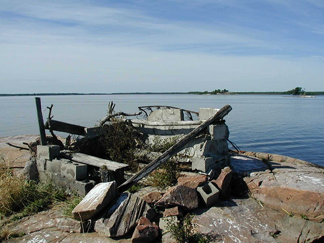
Photo 1: Duck Blind constructed of wood and cement blocks
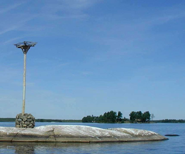
Photo 2: Man made nesting site over looking the Cache Bay Wetland Conservation Reserve
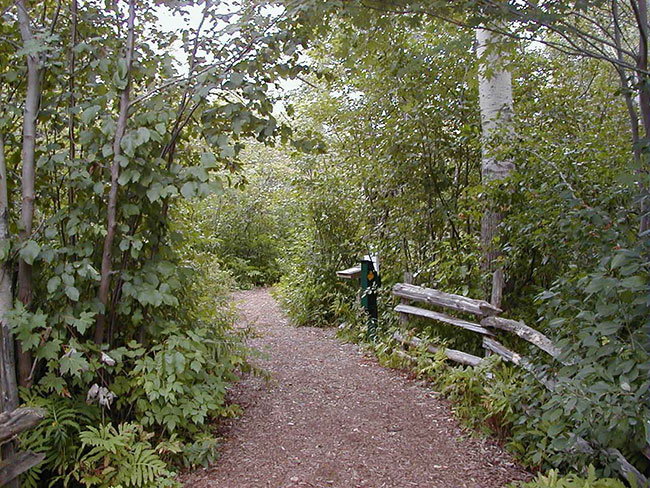
Photo 3: The upland areas of the Sturgeon River House Museum Trail
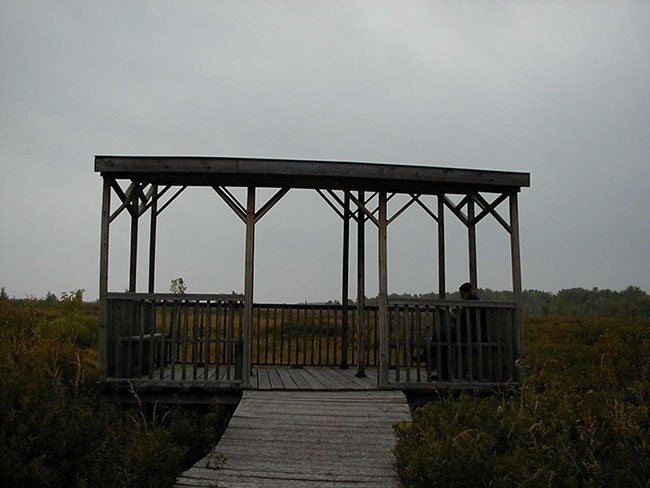
Photo 4: Sturgeon River House Museum Trail lookout over the fen portion of the conservation reserve
Appendix 1 - Procedural Guideline B – Land Uses – 'Test of Compatibility' (PL Procedure 3.03.05)
The Conservation Reserve policy provides broad direction with regard to the permitted uses. The policy provides only an indication of the variety of uses that will be considered acceptable in conservation reserves. The only caution is that "any new uses, and commercial activities associated with them, will be considered on a case by case basis, and, they must pass a 'test of compatibility' to be acceptable." What does a 'test of compatibility' mean?
An examination of this must start from the premise of why an area is set aside – specifically, its representative natural heritage values. Criteria are then identified to guide compatibility considerations. These criteria apply to the long-term acceptability of both existing uses and new uses.
The first 'test' is: "do proposed new land uses and/or commercial activities conform to the direction of the SCI/RMP for the conservation reserve? Would the new use(s) depart from the spirit of appropriate indicator land uses in the SCI/RMP?"
-
Conformity to SCI/RMP: SCI describe values for which an area has been set aside and the range of appropriate uses that will be permitted in the area. SCI may also speak to the acceptability of other 'new' uses currently not occurring in the area.
- Impact Assessment: If the proposed use(s) pass test 1 it is important to determine their impact on the area before they are approved. This should include the following:
- Impact on natural heritage values: "will the new use(s) impact any natural values in the area? If so how and to what degree? Is it tolerable?"
- Impact on cultural values: "will the new use(s) impact an historical or archaeological values in the area?"
- Impact on research activities: "will the new use(s) affect research activities in the area?"
- Impact on current uses: "will the new use(s) have any negative impact on the array of current uses?"
- Impact on area administration: "will the new use(s) increase administrative costs and/or complexity?" (For example, the cost of area monitoring, security and enforcement).
- Impact on accommodating the use outside the conservation reserve: "Could the use(s) be accommodated as well or better outside the conservation reserve?"
- Impact on socio-economics of the area: "will the new use(s) affect the community(ies) surrounding the area in a positive or negative way?" (For example, will the new use make an area less remote thereby affecting a local tourism industry that is dependent on the area’s remoteness for its appeal?"
- Impact on area accessibility: "does the new use(s) give someone exclusive rights to the area or a portion of the area to the exclusion of other existing uses?"
The following table provides a guide of indicator uses for the consideration of uses that may be permitted within conservation reserves. For any specific conservation reserve that 'test of compatibility' should be applied to determine which specific uses are acceptable.
Appendix 2 - Public Lands Act Policy (3.03.05) Conservation Reserve permitted use table
Indicator uses for conservation reserves
Recreation
| Permitted activities | Generic existing | Generic new | (C171) Specific |
|---|---|---|---|
| Sport fishing | Yes | Yes | Yes |
| Sport hunting | Yes | Yes | Yes |
| Food gathering | Yes | Yes | Yes |
| Facility infrastructure | Maybe | Maybe | Maybe |
| Non-trail snowmobiling | Maybe |
Maybe |
Maybe |
| Non-trail ATV use | Maybe |
Maybe |
Maybe |
| Rock climbing/caving | Maybe | Maybe | N/A |
| Canoeing/kayaking | Yes | Yes | Yes |
| Motorized boating | Yes | Yes | Yes |
| Picnicking | Yes | Yes | Yes |
| Camping | Maybe | Maybe | Yes |
| Trails | Yes | Maybe | Maybe |
| Hiking | Yes | Maybe | Maybe |
| X county skiing | Yes | Maybe | Maybe |
| Cycling | Yes | Maybe | Maybe |
| Horse riding | Yes | Maybe | Maybe |
| Snowmobiling | Yes | Maybe | Maybe |
Science, education & heritage appreciation
| Permitted activities | Generic existing | Generic new | (C171) Specific |
|---|---|---|---|
| Research | Yes | Yes | Yes |
| General walking | Yes | Yes | Yes |
| Photography and painting | Yes | Yes | Yes |
| Wildlife viewing | Yes | Yes | Yes |
| Outdoor education/interpretation | Yes | Yes | Yes |
| Collecting | No | No | No |
Commercial activities
| Permitted activities | Generic existing | Generic new | (C171) Specific |
|---|---|---|---|
| Food harvesting | Maybe | Maybe | No |
| Fishing | Maybe | Maybe | No |
| Baitfish harvesting | Yes |
Maybe | Yes |
| Trapping | Yes |
Maybe | Yes |
| Trap cabins | Yes | No | No |
| Resort-outpost camp | Yes |
No | No |
| Outfitting-bear management | Yes |
No | Yes |
| Wild rice harvesting | Yes | Maybe | No |
Resource management
| Permitted activities | Generic existing | Generic new | (C171) Specific |
|---|---|---|---|
| Inventory monitoring | Yes | Yes | Yes |
| Featured species management | Maybe | Maybe | Maybe |
| Natural systems management | Maybe | Maybe | Maybe |
Industrial activities
| Permitted activities | Generic existing | Generic new | (C171)Specific |
|---|---|---|---|
| Timber harvesting | No | No | No |
| Prospecting | No | No | No |
| Mining | No | No | No |
| Hydro generation | No | No | No |
| Energy transmission corridors | Yes | No | No |
| Communications corridors | Yes | No | No |
| Transport corridors | Yes | No | No |
| Resource roads (MNRF) | Yes | No | No |
| Land disposition | No | No | |
| Hunt camps | Yes |
No | No |
Appendix 3 - Glossary of terms
Biodiversity: The number and variety of organisms found within a specified geographic region2
Biological Control: Control of pests by disrupting their ecological status, as through the use of organisms that are natural predators, parasites, or pathogens. Also called biocontrol2
Biotite: A generally black or dark green form of mica that is from crystalline rocks and consists of a silicate of iron, magnesium, potassium, and aluminum3
Bog: Peat-covered areas or peat filled depressions with a high water table and a surface carpet of mosses, chiefly Sphagnum9
Canadian Shield: One of the world’s largest, low relief areas in the Earths crust that are composed of Precambrian crystalline rock, centred on Hudson’s Bay and extending for 8, 000, 000 square km1
Catchment: An area occupied by a closed drainage system, especially a region that collects surface runoff and contributes it to a stream, lake or other body of water. Also known as watershed or drainage basin9
Crown Land: Land owned by the provincial or federal government9
Cultural Heritage: Collective term describing examples of a society’s evolution (e.g. history, anthropology and archaeology) worthy of study and preservation5
Cultural Resources: Sites, features or artifacts related to the Province’s archaeology, anthropology or history, preserved in a natural setting5
Delta: A usually triangular alluvial deposit at the mouth of a river or a similar deposit at the mouth of a tidal inlet, caused by tidal currents2
Dredge: Any of various machines equipped with scooping or suction devices and used to deepen harbors and waterways2
Ecodistrict: An ecological landscape unit (ranging in resolution in hundreds of square kilometers) characterized by a distinct patterns in landform8
Ecoregion: An ecological landscape unit (ranging in resolution from hundreds of thousands to tens of thousands of square kilometers) characterized by distinct patterns of responses to climate as expressed by soils, hydrology, vegetation (species ranges and productivity), and fauna7
Ecosystem: An ecological community together with its environment, functioning as a unit2
Emergents: Herbaceous plants which rise out of the water9
Endangered Species: Species listed in regulation under Ontario’s Endangered Species Act. These species are threatened with extirpation from the province and in some cases extinction on a global basis9
Fen: Peatland characterized by surface layers of poorly to moderately decomposed peat, often with a well-decomposed peat near the base9
Gneiss: A crystalline rock, consisting, like granite, of quartz, feldspar, and mica, but having these materials, especially the mica, arranged in planes, so that it breaks rather easily into coarse slabs or flags2
Granite: A common, coarse-grained, light-colored, hard igneous rock consisting chiefly of quartz, orthoclase or microcline, and mica, used in monuments and for building2
Hornblende: A green to black amphibolic mineral, formed in the late stages of cooling in igneous rock2
Humic: Of, relating to, or derived from humus2
Hydrology: The science of water, its properties and laws, and its distribution over the earth’s surface9
Igneous Rock: Any of various crystalline or glassy rocks formed by the cooling and solidification of molten earth material1
Interspersion: The measure or degree of edge contact, or ecotone length that exists between adjacent vegetation communities9
Lacustrine: Of or relating to lakes2
Mesic: Of or relating to organisms or communities that have a moderate amount of moisture9
Northern Wetland Evaluation System: A rationale and protocol for assessing wetlands in northern Ontario in order to rate wetland function and determine its relative significance for a given area. The system considers the functional role wetlands play in maintaining critical ecosystem functions, providing social benefits, improving hydrological systems and water quality as well as protecting rare species9
OBM: Ontario Base Map, refers to a geographic division of Ontario according to lines of longitude into mapsheets based on the UTM map projection system6
Patent: An exclusive right or title2
Peatland: The extensive areas of northern Ontario having organic soils9
pH: A measure of the acidity or alkalinity of a solution, numerically equal to 7 for neutral solutions, increasing with increasing alkalinity and decreasing with increasing acidity. The pH scale commonly in use ranges from zero to fourteen2
Provincially Significant Species: The provincial rank is established by the Natural Heritage Information Center (NHIC). Listed species are based upon data and/or recommendations from a wide variety of sources including the Ontario Rare Breeding Bird Program Database, the Committee on the Status of Endangered Wildlife in Canada (COSEWIC), the Committee on the Status of Species At Risk in Ontario. A species is considered provincially significant if it is ranked as S1, S2, S3, SH or if it has been tracked by the NHIC. Species being tracked by the NHIC are generally known from fewer than 100 occurrences in Ontario and/or are COSEWIC or COSSARO designated9
Provincially Significant Wetland: Lands that are important on a provincial scale that are seasonally or permanently flooded by shallow water as well as lands where the water table is close to the surface; in either case the presence of abundant water has caused the formation of hydric soils and has favored the dominance of either hydrophytic or water tolerant plants9
Regionally Significant Species: Species that occur in a few populations or in very restricted distributions on a regional or local scale. Species selection is based on analysis of data from the Atlas of Breeding Birds in Ontario and Hills' Site Regions. Information has been updated by NHIC and specialists with expertise in breeding birds in their areas9
Silt: Mineral particles smaller than sand but greater than clay sizes4
Species of Special Status: Species that are the subject of unusual interest or unique concern. Applies specifically to wetland areas9
Staging Area: Any area where migratory birds congregate to eat and rest prior to continuing their journey9
Tombolo: A sandbar that connects an island to the mainland or to another island2
Topography: Graphic representation of the surface features of a place or region on a map, indicating their relative positions and elevations2
UTM: Universal Transverse Mercator; a cylindrical projection used for the Ontario Base Map system4 & 6
1 Encyclopaedia Britannica, Inc. 2002. Encyclopaedia Britannica Online.
2 Dictionary.com. 2003. Lexico Publishing Group. www.dictionary.com
3Merriam – Webster. 2002. Merriam – Webster Online.
4Chapman, L.J, and D.F. Putnam. 1984. The Physiography of Southern Ontario, Third Edition. Ontario Geological Survey
5OMNR. 1992. Ontario Provincial Parks: Planning and Management Policies: 1992 Update. OMNR
6OMNR. 2001. Glossary. http://www.mnr.gov.on.ca/mnr/forests/forestdoc/ebr/fimpdfs/glossary.pdf [link inactive]
7OMNR. 1996. Forest Management Planning Manual. Toronto: Queen’s Printer for Ontario
8Crins, William J and Peter W.C. Uhlig. 2002. Ecoregions of Ontario: Modifications to Angus Hills' Site Regions and Districts Revisions and Rationale.
9OMNR. 1993. Ontario Wetland Evaluation System Northern Manual.
Figure 1: Cache Bay Wetland Conservation Reserve location map
Enlarge Figure 1: Cache Bay Wetland Conservation Reserve location map
Figure 2: Cache Bay Wetland Conservation Reserve forest values map
Enlarge Figure 2: Cache Bay Wetland Conservation Reserve forest values map
Figure 3: Cache Bay Wetland Conservation Reserve recreational values & tenure map
Enlarge Figure 3: Cache Bay Wetland Conservation Reserve recreational values & tenure map
Footnotes
- footnote[1] Back to paragraph New uses will be considered on a case by case basis provided they do not impact the natural heritage values for which the area was established, and must pass a 'test of compatibility' to be acceptable.
- footnote[2] Back to paragraph For retrieval of game only
- footnote[3] Back to paragraph Transfer requests will be considered in the context of a Statement of Conservation Interest (SCI) or Resource Management Plan (RMP) for each conservation reserve.
- footnote[*] Back to paragraph Existing dispositions will continue, however, as opportunities arise the Ministry will acquire and/or remove them outside of the conservation reserve.