Constance Lake terms of reference
Terms of reference for community based land use planning in Constance Lake under the Far North Act.
Prepared in partnership by:
Constance Lake First Nation and the Ontario Ministry of Natural Resources and Forestry
February 2014
Date: July 9, 2014
Constance Lake First Nation and the Ministry of Natural Resources and Forestry are pleased to sign the Terms of Reference for the Constance Lake First Nation Community Based Land Use Plan. Approvals have been provided by:
- Constance Lake First Nation Band Council Resolution; and
- Ontario, by the Minister of Natural Resources and Forestry administering the Far North Act.
As we begin this planning process, Constance Lake First Nation and the Ministry of Natural Resources and Forestry affirm our commitment to work together with mutual respect and in good faith.
On behalf of Constance Lake First Nation
Signed by
Chief Fred Sackaney
Constance Lake First Nation
On behalf of Ontario
Signed by
Honorable Bill Mauro
Minister of Natural Resources and Forestry
Acronyms
- AOU
- Area of the Undertaking
- ATK
- Aboriginal Traditional Knowledge
- CBLUP
- Community-Based Land Use Plan
- CLFN
- Constance Lake First Nation
- LUPD
- Land Use Planning Department (CLFN)
- MNRF
- Ministry of Natural Resources and Forestry
- NBI
- Northern Boreal Initiative
- NTFP
- Non-timber Forest Products
- WGC
- Working Group Committee
- JPT
- Joint Planning Team
- MNDM
- Ministry of Northern Development and Mines
Vision statement
To provide stewardship for our lands and resources through the knowledge and guidance of our Elders and heritage. Through this vision, we will seek a balanced approach that protects community interests while also seeking sustainable development opportunities.
Mission statement
Constance Lake First Nation is dedicated to respecting the teachings and wisdom of our Elders, keeping the land, providing for our continued way of life, and seeking opportunities for Our People. Maintaining a relationship to the land to support our Native way of life in conjunction with and through community based land use planning is imperative.
Historical overview
The Constance Lake First Nation (CLFN) members are of Cree, Oji-Cree and Ojibway descent. Our ancestors inhabited the Kenogami, Kabinakagami, Nagagami, Pagwachuan, Wakashi, Awagakama, Squirrel, Fox, Pitukupi, Little Ash, Big Ash, Little Current, Drowning, Ridge, Albany and Shekak river systems and Pledger, Pitukupi, Constance, Trilsbeck, Serinack, Martison, Ridge, Melanson, Fushimi, Fox, Bannerman, Luhta (Medicine Creek) lake systems since time immemorial, as told by Elders in the eighteen hundreds and early nineteen hundreds.
In 1905, the federal government negotiated Treaty Number 9 and these people were attached to the agreement as a subdivision of the Fort Albany First Nation on James Bay. Mammamattawa (English River) is where the Kenogami River joins with the Kabinakagami and Nagagami Rivers; both the Hudson’s Bay Company and rival Revillon Frères had fur trading posts at this location. This area became the Mammamattawa (English River) Reserve and now belongs to the CLFN.
There is an abundance of lakes, rivers and creeks throughout the area with large stands of birch, poplar, jack pine, white and black spruce, tamarack and cedar continues to play a vital role in the daily lives of community members as part of their historical connection to their traditional land.
In 1945 the majority of CLFN members moved to the community’s current location, while keeping up the Mammamattawa Reserve. Today, CLFN is located in the District of Cochrane, 32 km west of Hearst, Ontario. CLFN is a progressive and rapidly growing community of 1605 members of Cree and Ojibway ancestry with approximately 820 living on reserve. The reserve is 7686 acres (3,110 hectares) in size, of which approximately 18 acres (7 hectares) are covered by water.
Introduction
Initiation of Community Based Land Use Planning
In 2002, CLFN began working with Ontario through the Northern Boreal Initiative (NBI), which focused on commercial forestry opportunities for the boreal forest north of the Area of the Undertaking (AOU). The NBI began the formal planning efforts to document Aboriginal Traditional Knowledge (ATK) in support of land use planning. The planning process has since been broadened in scope to arrive at Community Based Land Use Planning under the authority of the Far North Act, 2010.
CLFN engaged in the Community Based Land Use Planning process and worked to develop a Terms of Reference to guide the designation of a planning area and guide the development of a community based land use plan. CLFN, in partnership with Ontario, represented by the Ministry of Natural Resources and Forestry (MNRF), will work together to develop land use direction for the area indicated by CLFN as its planning area of interest (Figure 1) for portions of its traditional land north of the AOU.
CLFN has made substantial efforts to collect information on spiritual, cultural and natural values and sites present in its traditional land. Such research has allowed the First Nation to further identify traditional use areas.
The planning processes will support the further analysis of collected information as well as offer the opportunity to continue to gather and document information in order to build CLFN’s ATK of land use values and occupancy, both historical and current. This information will serve as the foundation for the CLFN CBLUP within its traditional territory.
The planning process will also provide a new framework for increasing community participation and transferring and incorporating ATK into the planning process. The planning process will also help build further internal capacity to continue to work jointly with MNRF to implement the CBLUP.
1.0 Purpose
1.1 Reasons for planning
CLFN wishes to proceed in developing a CBLUP for a planning area of interest within the Far North of Ontario. CLFN, in partnership with Ontario, represented by MNRF, will devise land use designations, supported by policy direction, for areas within CLFN’s indicated planning area of interest.
CLFN appreciates the value and importance of passing knowledge on to future generations. For this reason, CLFN will strive to undertake and complete ATK compilation, and to produce film and other visual and audio products to better expose the Community and especially the youth to CLFN’s history, culture and traditional values. The community recognizes and respects that time is of the essence in retrieving and documenting Elders’ knowledge and oral history. This information is critical to the development of CLFN’s CBLUP, and serves as a major focal point of cultural interest on which planning and management decisions are based.
Various types and forms of information will continue to be brought into the planning process from many sources. All information brought to the planning process will help to inform planning decisions made by the community and the joint planning team as the CBLUP is developed.
2.0 Goals, objectives and principles
2.1 Goal(s) for planning
Land use designations housed in the approved CBLUP for the planning area will be led by the CLFN people in partnership with the Ontario government.
2.2 Objectives of planning
Objectives under Section 5 of the Far North Act, 2010 have been considered in the preparation of the Terms of Reference, and will be continue to be considered during the creation of the draft and final CBLUP. If the Far North Land Use Strategy is in place at the time the CBLUP is prepared, it will also be taken into account.
The following considerations will also be key to the development of a Draft and Final CBLUP:
- Commitment of CLFN and Ontario as partners, to collaboratively develop a comprehensive land use plan
- Planning focus of seeking balance between protection and sustainable development opportunities
- Collective development of land use designations to enhance future abilities to build a strong economy and sustain CLFN community members for future generations
- Protection of areas of significant cultural value
- Protection of ecological systems
- Maintenance of biological diversity, ecological processes and functions including the consideration of ecological matters at local and landscape-scale
2.3 Principles for planning
- Respect traditional values and uses, and incorporate these values into the planning process wherever possible
- Follow the guidance of CLFN Elders
- Commit to learn, improve and strive for excellence on an ongoing basis in all land use planning decisions
- Consider the best available data and information
- Use base line information with regard to the physical environment and in the context of climate change to protect community health and safety
- Respect future generations and their interests
- Respect the various perspectives and information brought to the planning process
- Give respectful consideration to ATK and land uses and contemporary science, to make wise land use decisions to provide opportunities for future generations
3.0 Training and education
Local capacity building is a very high priority for CLFN, at all levels of the planning process, from initial plan development to plan implementation. Education and training opportunities are very important to CLFN and formal provisions will be put into place to help build local capacity whenever possible.
Whether a local candidate or consultant is the hired planner, this person will be required, as part of the job description, to conduct on-the-job training with local people in order to build their capacity to complete similar activities in the future and to participate and inform the planning process. Furthermore, Constance Lake representatives will be provided with formal training programs in partnership whenever possible by Colleges or Universities, or other educators who are able to deliver hands- on training and video conferencing in the Community.
The target is to engage as many local community members during the planning process as possible through the community information sessions and smaller community representative group meetings to help build CLFN capacity. This approach will enable community members to further understand community-based land use planning through direct involvement in land use planning activities during the process itself.
Capacity building is not considered a one-way flow of information into CLFN. While mutual capacity building will support opportunities for people in CLFN to learn and develop meaningful skills, it should also create opportunities for people in provincial government, private organizations and other First Nations to learn from the knowledge and experience of the community. Members of the JPT have spoken to external groups about the process and their experiences, and will continue to exchange more of this type of information into the future.
4.0 Scope of planning
4.1 Planning area
CLFN has identified a draft planning area of interest for the purpose of preparing a CBLUP. The draft Planning Area of Interest is approximately 5,651,754 acres (2,287,184 hectares) in size and is situated north of Constance Lake Reserve in the Far North.
The draft delineation of the CLFN Planning Area of interest can be found in figures 1 and 2. It is based on a number of factors including but not limited to:
- CLFN’s extensive past and present connection with the land and waters of its traditional territory;
- ongoing ATK research conducted with many CLFN community members from 1997 to the present, formally conducted through interviews with Elders, river trips and historical research, and;
- on-going dialogue with neighbouring communities.
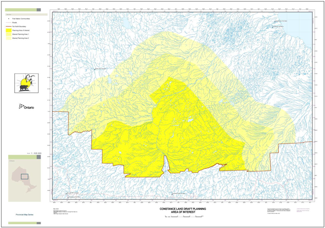
The community has focused its efforts on land use planning activities north of the AOU for the Far North land use planning initiative. The draft planning area of interest has been sectioned into three areas identified as Core area, Shared Planning Area 1 and Shared Planning Area 2.
Core area:
- The area of interest where CLFN is the sole First Nation with influence over decision making
Shared planning area #1:
- The area where CLFN and appropriate neighbouring communities have shared influence over decision making
Shared planning area #2:
- The area where CLFN has less planning influence over decision making than appropriate neighbouring communities, but would like to be informed and involved in planning discussions with neighbouring communities
Discussions with neighbouring First Nation communities concerning shared planning areas were initiated during the drafting of the Terms of Reference. CLFN intends to discuss and use best efforts to reach agreement on land use direction of shared areas with the appropriate neighbouring communities before finalizing the planning area and draft land-use plan. Once agreement has been reached between CLFN and MNRF on a final CLFN planning area, it will be formally proposed for designated under the Far North Act, 2010.
4.2 Shared lands
CLFN is committed to building relationships and consulting with adjacent First Nations to share its intended planning area of interest, and to work collaboratively with its neighbours to understand their interests in the shared planning area, where applicable. The neighbouring communities include: Long Lake #58, Ginoogaming, Marten Falls, Aroland, Moose Cree, Kashechewan, Fort Albany, Attawapiskat.
A shared areas committee will act as an informal sub-committee to the JPT. This committee will be the only group engaging in all shared areas discussions with the previously listed neighbouring communities. The committee will ensure consistent representation from CLFN and MNRF representatives as required, with the expertise to engage in the discussions about shared areas with neighbouring communities. This approach will be an effective way to enable productive and positive results, as well as enable shared areas matters to be reviewed in detail while other planning matters move forward concurrently.
Through consistent and open dialogue with the neighbouring communities identified, shared lands interests will be addressed in a manner that is suitable to parties with identified interests to collectively address a path forward and be incorporated into the planning process.
4.3 Planning subjects & objectives
Planning direction will incorporate land use zoning to support or restrict intended outcomes on the land. This direction will be housed in the Final Plan for the Planning Area and will consider, but not be limited to, the following areas of interest:
4.3.1 Culture and heritage areas
- Identify burial grounds, culturally important landscape features, and significant cultural and/or spiritual gathering sites
- Document historical use of the land and resources
4.3.2 Mineral development
- Use the best available information about the mineral and energy potential of the planning area to support the land use planning process
- Identify areas suitable for current and future mineral and energy exploration and development activities
4.3.3 Protected areas
- Designate 1 or more protected areas
- Identify and define special, sheltered and preserved areas
- Shelter areas of ecological, traditional, and spiritual significance through an interconnected network to enhance protection value
- Explore continuity of protected corridor interest with adjacent planning areas
- Identify any proposals for changes to existing parks or protected areas
- Consider designating planning areas adjacent to existing provincial parks as protected areas
4.3.4 Aggregates
- Identify potential areas for bedrock and surficial extraction for community and/or commercial opportunities
4.3.5 Waterways & waterbodies
- Determine areas of cultural and spiritual importance and traditional transportation routes
- Ensure drinking source water protection
- Identify areas of hydro-electric potential and recreational importance
4.3.6 Commercial forestry
- Identify areas that could be made available to commercial forestry activities
- Designate appropriate harvest types in enhanced management areas
4.3.7 Non-timber forest products (NTFP)
- Identify land use in which the community’s NTFP interests for traditional or commercial purposes may be pursued
4.3.8 Climate change adaptation
- Provide for flexibility and adaptation in the CBLUP for changing climatic considerations and the potential climate-induced effects on the land into the future
4.3.9 Infrastructure
- Identify potential infrastructure corridors, including water crossings, to support future access needs for the community and for resource development and related infrastructure such as power transmission, communications etc.
- Consider linear corridors, such as electrical transmission corridors, roads and pipelines, in the context of land use designations and their compatibility with other land features
- Identify areas where access restrictions may be required to preserve remoteness while enabling economic activities
4.3.10 Tourism
- Identify potential future remote tourism opportunities to support economic development for the First Nation
- Identify localized non-remote tourism opportunities
4.3.11 Renewable energy
- Assess potential renewable energy economic opportunities using the most accurate resources and information available from both internal and external sources. The opportunities could include wind, water, biomass, solar and tidal energy options, based on feasibility and community interest.
4.3.12 Existing uses
- As part of the planning process, existing uses will be identified as ongoing, where applicable (i.e. Tourism, mining claims, infrastructure)
In addition to the planning subjects listed, the JPT will seek advice for addressing consideration of cumulative effects.
4.4 Planning outcomes
Through the land use planning process, CLFN and Ontario will collaboratively address land use interests to define land use designations that are suitable to CLFN needs that will support social, economic, and environmental interests. Specific plan outcomes will include, but are not limited to the following:
- Record and analyze ATK to support the planning process
- Define a designated planning area
- Designate one or more protected areas
- Identify the goals and objectives of the plan
- Identify a review period for the Final Plan
- Identify land use designations and categories to guide what development, land uses and activities are permitted in each area
- Identify how the plan has addressed significant cultural and spiritual features and land uses
- Describe how the plan has addressed features and land uses adjacent to the planning area, and how CLFN & Ontario wishes to see these areas complement direction in the plan
- Document considerations of ecological and economic matters at both local- and landscape-scale and describe how those considerations were incorporated into planning decisions
- Consider land use direction to assist in supporting species at risk concerns
- Identify and transparently support planning decisions with appropriate supporting information
- Guide subsequent plan implementation, including directing how both CLFN and Ontario will work in collaboration to address subsequent land use planning decisions
The plan will be prepared in a manner that is consistent with the recognition and affirmation of existing Aboriginal and treaty rights in section 35 of the Constitution Act, 1982, including the duty to consult.
5.0 Land use planning process
Land use planning follows a step-by-step consensus based process for decision making that is consultative in nature. Through all stages of the planning process, social, economic and environmental considerations will be fully incorporated to guide balanced decision making.
CLFN and MNRF, as planning partners, will begin planning with a consensus on the Terms of Reference that sets out the process details for community-based land use planning. The Terms will be approved by the First Nation and Ontario, and will guide the planning process to build a community based land use plan for CLFN’s designated planning area. CLFN and MNRF may amend the Terms of Reference as needed, provided that the amendment receives the formal approval of both parties.
Components common to land use planning are the development of Terms of Reference, compilation of background information, analysis of planning options and the preparation of a draft and a final CBLUP. As planning proceeds through these components, the Joint Planning Team (JPT) will work to incorporate Ontario’s broader policy direction and emerging guidance, and if a Far North Land Use Strategy is in place at the time the CBLUP is prepared, it will also be taken into account.
5.1 Planning structure
5.1.1 Roles and responsibilities
In partnership with the Province of Ontario, CLFN has created an administrative structure to guide the community through the land use planning process. The roles and responsibilities are as follows:
- Community
The Constance Lake CBLUP will reflect information and knowledge from the community membership. The community will be invited to be involved through the entire planning process and support the plan with ongoing dialogue, information sharing and plan review during all stages of plan development.
- Chief and Council & Ontario
Key planning documents, including specifically the Terms of Reference, Draft Plan and Final Plan, will be shared with the community and Chief and Council for their periodic review. Any suggested revisions will be reviewed and incorporated by the JPT, as necessary. Final versions will be presented back to the Chief and Council and Ontario for approval.
- Joint Planning Team
Collectively, the JPT consists of individuals from the CLFN Land Use Planning Department (LUPD), MNRF Far North Branch staff, and community group representatives.
The LUPD, in cooperation with MNRF Far North Branch, is tasked with preparing CBLUP documents to the satisfaction of CLFN, in draft and then in a final version. These documents include: Terms of Reference, draft and final CBLUP in addition to any other supporting documents to inform or support the CBLUP process, as required.
The LUPD staff are employees of CLFN and are responsible for carrying out ATK collection and maintenance, data management, administrative functions and other required duties on behalf of the Community. The LUPD provides information to the Community and leadership on CBLUP efforts on an ongoing basis.
As a member of the JPT, MNRF has responsibilities in assuring that provincial interests including maintaining biological diversity and ecological processes and functions are considered during planning. MNRF will also ensure information on the subject of resource development is brought forward during the draft planning stage. MNDM will help inform these discussions with supporting geoscience and mineral development potential.
MNRF will also facilitate public notices at appropriate times during the planning process, including posting notices on the Environmental Registry for the Terms of Reference and the draft and final CBLUPs.
The JPT is made up of the following:
- Land Use Planning Department (LUPD) Staff
- Elder representative
- Youth representative
- Women representative
- Traditional user representative
- MNRF Far North Branch Staff
- Resource Support
Resource support will be sought at appropriate times within the planning process from Elders, expert consultants and technical advisors who will contribute information and knowledge to the process. This will help ensure that all available information is accessible to the community and JPT throughout the planning process, and can be used to support decision- making and policy direction. Resource support is not a formal group but rather, advisors to be accessed to gain the best available information throughout the planning process.
Figure 3. Planning structure
- Resource Support: Contributes information and knowledge for consideration
- First Nation member
- MNRF, MNDM, MOECC
- Expert consultants
- Technical advisors
- Other support as required
- Constance Lake First Nation Membership
- Provides guidance and support to inform all stages of the planning process
- Joint Planning Team
- Under the direction of the CLFN Elders/membership and Ontario, the JPT drives the development of all planning documents to support the creation of the CBLUP
- Chief and Council/Ontario
- Jointly endorse Terms of Reference, and Final Plan
5.1.2 Authority
The planning process is designed with the following understandings for authority, related responsibilities, and decision making:
The Far North Act, 2010 identifies the requirements and authority for approvals, including for:
- Terms of Reference
- Final Land Use Plan
Joint approvals for each of the above are required by:
- CLFN Chief and Council; and
- Minister of Natural Resources and Forestry
Approval of the final plan will be by Minister’s Order under the Far North Act, 2010 and by First Nation Band Council Resolution.
Prior to approval of the draft plan, the planning area will be designated under the Far North Act, 2010 via Minister’s Order.
Once a CBLUP is approved, provincial regulatory decisions on land use activities (allocation, disposition or use) and the activities themselves must be consistent with the land use designations and permitted land uses and activities specified in the plan. In addition, MNRF and other provincial agencies continue to have obligations set out in provincial policy and legislation.
5.1.3 Decision-making
A consensus-based decision-making approach will be employed at all stages in the planning process between CLFN and Ontario. This will include any and all recommendations as arrived at within the JPT.
Written records of all decisions pertaining to the draft and final CBLUP made as part of the planning process will be maintained and approved by both parties.
In the event that an issue that cannot be resolved through consensus arises, and a conflict resolution process is deemed necessary, guidance will be sought from CLFN Chief and Council and the MNR Far North Manager.
5.1.4 Planning phases
The formal process that will enable CBLUP to achieve a final plan has been categorized into phases with associated tasks and timelines for each. CLFN planning work is supported under the framework of the Far North Land Use Planning Initiative and under the authority of the Far North Act, 2010.
A variety of support mechanisms and partners have been involved to ensure the best results with the resources available.
Phase 1
Planning initiation and engagement
Timeline: 2005 – 2013
- Historical work under the NBI
- Gather ATK
- Seek funding support and approval
- Assemble CLFN WGC
- Hold discussions to advise development of a Terms of Reference
- Continue to gather ATK
- Gain a common understanding between CLFN and Ontario MNRF with respect to land use planning objectives to begin structuring the planning process
Phase 2
Terms of Reference
Timeline: 2013 – Spring 2014
- Formalize the JPT with WGC members
- Determine a draft planning area of interest
- Describe objectives
- Assemble ATK data
- Communicate with the community membership to develop awareness
- Invite participation from community membership
- Discuss shared areas of planning interest with neighbouring communities
- Seek joint approval/endorsement of Terms of Reference
- Post proposal on the Environmental Registry for the general public, industry, stakeholders and other interest groups
Phase 3
Draft Community Based Land Use Plan
Timeline: Spring 2014 – Summer 2015
- Obtain, assess and analyze ATK and western science information
- Collection of economic development and resources development potential
- Communicate with community membership to ensure awareness
- Invite participation from community membership
- Develop a preliminary draft CBLUP
- Share the preliminary draft plan with community membership both on- and off-Reserve, and invite comments
- Work with community members and Ontario to reach consensus on the preliminary draft plan
- Prepare draft recommendations describing proposed Land Use Designations (i.e. zoning) and associated direction for lands, waters and resources
- Ensure involvement opportunities for all community membership and share draft plan information with off reserve membership
- Review, consider and incorporate comments received from sharing the preliminary draft plan
- Discuss shared areas of interest and proposed land use designations with neighbouring communities
- Provide opportunities for the general public, industry, stakeholders and other interest groups to comment
- Post a proposal about the final draft CBLUP on the Environmental Registry
- Seek the final Planning Area of Interest to be formally designated
Phase 4
Final Community Based Land Use Plan
Timeline: Summer 2015 – Winter 2015
- Consider public input and summarize the JPT’s response to the input
- Make appropriate revisions and incorporate them into the final CBLUP
- Seek community and Ontario consensus
- Seek joint approval/endorsement of the final CBLUP
- Post decision notice on the Environmental Registry for the general public, industry, stakeholders and other interested groups.
Phase 5
Plan implementation
Timeline: 2016 onward
- Work in partnership to address implementation procedures consistent with the Final Plan
- Review and amend the CBLUP, when required
- Ongoing information gathering, assessing, and analyzing information, as necessary (ATK and western science)
6.0 Information management
CLFN values and appreciates the importance of collecting, documenting and sharing knowledge with community members today and also with future generations. It is recognized and respected that time is of the essence in retrieving and documenting Elders’ knowledge and oral history. Great efforts have been and will continue to be made, in preserving information for the purpose of sharing local history as well as cultural and traditional values with the community members, especially the youth. Products have been developed from previous information gathered to include: ATK work, film productions and other visual/audio products.
Information previously collected and information collected from here forward from a variety of sources, will be continuously brought forward and considered to help support and inform the joint planning process. It will also serve as a major focal point of cultural interest as the basis for preparing land use direction, planning, and management decisions. This information will serve as the grassroots basis for the development of a CBLUP that is unique to CLFN. A joint protocol between the community and MNRF will be established by the JPT that will outline what information will be brought forward by each partner and how it will be used, while respecting and protecting Indigenous Knowledge.
All Indigenous Knowledge used to support the planning process and decisions will remain with the community unless the community deems it shareable with the Province of Ontario. This would particularily apply to sensitive areas the community does not want publicly identified.
MNRF will facilitate and support the JPT with the best available Provincial information and data, to be used for the purpose of land use planning. In addition, the JPT will identify appropriate information management strategies to be used in supporting the development of the CBLUP.
The JPT will ensure compliance with requirements for information under the authority of the Freedom of Information and Protection of Privacy Act, and the Archives and Recordkeeping Act, 2006. Notices required for consultation purposes under the Environmental Bill of Rights, 1993 will primarily be the responsibility of the MNRF.
The JPT will oversee communications and delegate as required, including developing and ensuring public notices are submitted as required, compiling the appropriate mailing list, initiating mail out of planning phase information, providing notice of meetings, and sharing any other information deemed appropriate.
MNRF and CLFN will provide public notice of all supporting planning documents including the Terms of Reference, Draft Plan and Final Plan. With the exception of ATK or other information that CLFN deems to be confidential, all formal input and comments relating to the planning process and documents that are received during the planning process will be documented and available as an official planning record. Copies of all formal input and comments received during the process will be provided to the JPT.
7.0 Contacts
Constance Lake First Nation:
FN LUP Coordinator
Constance Lake First Nation
P.O. Box 4000
Constance Lake, ON
P0L 1B0
Ministry of Natural Resources and Forestry:
Director, Far North Branch
Ontario Government Complex
Highway 101 East
South Porcupine, ON
P0N 1H0
Far North Planner
Ontario Government Complex
Highway 101 East
South Porcupine, ON
P0N 1H0