Land use planning process in the Far North
The process for developing community based land use plans in the Far North of Ontario.
About the Far North
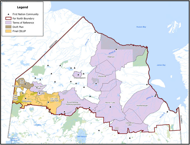
The Far North covers 42% of Ontario’s land mass. About three times the size of Lake Superior, it stretches from Manitoba in the west to James Bay and Quebec in the east (see Figure).
It is home to:
- 24,000 people (90% of them First Nations)
- 31 First Nations communities
- two municipalities (Pickle Lake and Moosonee)
- one community with a Local Service Board (Moose Factory)
The Far North has 2 distinct ecological regions, which play a key role in helping reduce global warming:
- bogs and fens of the Hudson Bay Lowlands
- boreal forest of the Canadian Shield
They also provide essential habitat for:
- more than 200 sensitive species, including species at risk like woodland caribou and wolverine
- Ontario’s only populations of polar bears, beluga whales and snow geese
Economic development
The natural resource potential in the Far North is great and demand is growing. This means there is opportunity for responsible resource development which will benefit Far North First Nation communities and Ontario. To help ensure sustainable development, the Ontario government and First Nations are working together on community based land use planning.
Learn more about community based planning
Far North of Ontario map
The Far North Act
The Far North Act came into effect on January 31, 2011. The Act provides for community based land use planning in the Far North which:
- sets out a joint planning process between First Nations and Ontario
- supports the environmental, social and economic objectives for land use planning in Ontario
- is done in a manner that is consistent with the recognition and affirmation of existing Aboriginal and treaty rights in section 35 of the Constitution Act, 1982, including the duty to consult
Community based land use planning
Community based land use planning enables joint decision making through a joint planning process.
Planning teams are composed of First Nations and Ontario representatives. The joint planning team works together to make consensus-based recommendations on which lands will be dedicated to protection and which lands will be open for potential economic development, including:
- forestry
- tourism
- mining
- renewable energy
Joint planning process
- Far North First Nations wishing to prepare a community based land use plan initiate the process.
- A joint planning team with representatives from First Nations and the ministry is established.
- A jointly approved Terms of Reference (TOR) sets out the objectives and process for developing a community based land use plan and includes the roles and responsibilities of the joint planning team.
- Aboriginal traditional knowledge, land, science, and resource information is gathered and documented to inform the development of the community based land use plan.
- Opportunities for public input (including posting on the Environmental Registry of Ontario) are provided at the TOR, Draft and Final Plan stages.
- A draft plan that proposes land uses (areas that are open for development and areas that are set aside for protection) and permitted activities is prepared.
- A final community based land use plan is prepared and approved by the First Nation and the Government of Ontario. It is posted online and on the Environmental Registry of Ontario.
Related reports
There are two published reports available which are valuable sources of information for First Nations and Ontario as we work together to develop community based land use plans:
- Far North Advisory Council: Consensus advice to the Ontario Minister of Natural Resources, developed by the Far North Advisory Council consisting of representatives from the resource industry and environmental organizations
- Science for a changing Far North, developed by the Far North Science Advisory Panel
If you would like a copy of either of these reports, email your request to the Far North Branch at FarNorthFeedback@ontario.ca.
Approved plans, draft plans and terms of reference
Pikangikum
Whitefeather Forest Land Use Strategy (2006)
Cat Lake-Slate Falls
Cat-Lake Slate Falls Community-Based Land Use Plan (2011)
Terms of Reference for Cat Lake-Slate Falls Community-based Land Use Planning (2008)
Pauingassi
Pauingassi Community-Based Land Use Plan (2011)
Pauingassi Terms of Reference (2009)
Little Grand Rapids
Little Grand Rapids Community-Based Land Use Plan (2011)
Little Grand Rapids Terms of Reference (2009)
Deer Lake
Deer Lake Draft Community-Based Land Use Plan (2015)
Deer Lake Terms of Reference (2013)
Eabametoong & Mishkeegogamang
Eabametoong & Mishkeegogamang First Nations Terms of Reference (2013)
Marten Falls First Nation
Marten Falls First Nation Terms of Reference (2013)
Wawakapewin First Nation
Wawakapewin First Nation Terms of Reference (2014)
Constance Lake First Nation
Constance Lake First Nation Terms of Reference (2014)
Webequie First Nation
Webequie First Nation Terms of Reference (2014)
McDowell Lake First Nation
McDowell Lake First Nation Terms of Reference (2016)
Kashechewan First Nation
Kashechewan First Nation Terms of Reference (2017)
Weenusk First Nation
Weenusk First Nation Terms of Reference (2017)
