Eabametoong and Mishkeegogamang First Nations Far North community based land use planning terms of reference
The terms of reference for Eabametoong and Mishkeegogamang First Nations Far North community based land use planning.

![]()
July 15, 2013
Eabametoong First Nation, Mishkeegogamang First Nation, and the Ministry of Natural Resources are pleased to sign the Terms of Reference for the Taashikaywin Community Based Land Use Plan. Approvals have been provided by:
- Eabametoong First Nation Band Council Resolution;
- Mishkeegogamang First Nation Band Council Resolution; and
- Ontario, by the Minister of Natural Resources administering the Far North Act.
As we begin this planning process, Eabametoong First Nation, Mishkeegogamang First Nation and the Ministry of Natural Resources affirm our commitment to work together with mutual respect and in good faith.
On behalf of Eabametoong First Nation
Signed,
Chief Elizabeth
Atiookan
Eabametoong First Nation
On behalf of Mishkeegogamang First Nation
Signed,
Chief Conmie Gray-MacKay
Mishkeegogamang First Nation
On behalf of Ontario
Signed,
Honourable David Orazietti
Minister of Natural Resources
Foreword
Eabametoong First Nation and Mishkeegogamang First Nation have prepared this Terms of Reference to guide the preparation of a Community Based Land Use Plan, a project jointly led by the First Nations working together with Ontario, as represented by the Ministry of Natural Resources (MNR) in the context of Ontario’s Far North Land Use Planning Initiative. The First Nations have given the name Taa Shi Kay Win (‘Taashikaywin’) to the project, which translates to “our places on the Earth and in nature’s realm”, and/or “our environment” to this planning initiative.
This document is titled Terms of Reference Taashikaywin 2013 (‘Terms-2013’). It is approved by the First Nations (via Band Council Resolution) and the Minister of Natural Resources under the Far North Act, effectively replacing a previously-approved Terms of Reference dated April 13, 2010. Commitments from the 2010-approved Terms are carried forward. The joint planning team has prepared Terms-2013 and sought new approvals primarily to adopt and incorporate Far North Act provisions and requirements for planning that came into effect in 2011 and to revise the guidance for designation of a planning area. In addition, edits have been made where needed to ensure all contents are up to date.
The Far North Act is a key component of Ontario’s Far North Land Use Planning Initiative as it provides a legal foundation for community based land use planning in the Far North that:
- sets out a joint planning process between the First Nations and Ontario;
- supports the environmental, social, and economic objectives for land use planning for the peoples of Ontario; and
- is done in a manner that is consistent with the recognition and affirmation of existing Aboriginal and treaty rights in section 35 of the Constitution Act, 1982, including the duty to consult.
Taashikaywin will be guided by the First Nations and by the emerging policies and processes established with the Far North Land Use Planning Initiative. Taashikaywin provides a framework for integrating economic, social and environmental values, and will address all land use subjects within the communities’ planning area. The resulting Community Based Land Use Plan (“The Plan”) will be agreed to by the First Nations and Ontario. Nothing in this Community Based Land Use Plan shall be construed so as to abrogate or derogate from the protection provided for the existing aboriginal or treaty rights of the aboriginal people of Canada as recognized and affirmed in section 35 of the Constitution Act, 1982.”
Figure 1: Taashikaywin reference map
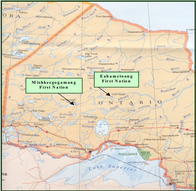
Enlarge Figure 1: Taashikaywin reference map
The communities of Mishkeegogamang and Eabametoong First Nations are located in Northwestern Ontario as shown on the reference map, Figure 1.
The planning partners of Mishkeegogamang, Eabametoong, and the MNR agree to work in good faith to provide a Community Based Land Use Plan following these Terms of Reference.
1.0 Purpose / reasons for planning
On 21 February 2002, a Memorandum of Understanding was signed between Eabametoong First Nation and Mishkeegogamang First Nation confirming our intention to work cooperatively in land use and resource development planning within our respective and contiguous Traditional Use Areas. Eabametoong and Mishkeegogamang began working together with MNR in association with the Northern Boreal Initiative, an “orderly development framework” to address community interests through planning, including the potential to seek a Sustainable Forestry Licence. Eabametoong First Nation and Mishkeegogamang First Nation are now continuing this work in partnership with Ontario in the context of the Far North Land Use Planning Initiative.
Eabametoong First Nation and Mishkeegogamang First Nation have entered into this planning partnership with the Ministry of Natural Resources to achieve:
- Community Based Land Use Planning in Their Respective Traditional Use Areas. This includes land use planning for all values within the planning area including: timber and non-timber forest values; renewable energy potential values (e.g., wind, water and transmission): mineral values; cultural values; ecological values (e.g. wildlife, plant and aquatic); water quality; recreation & tourism values; and other values that become apparent during the course of the planning process. The process will seek to provide Cultural/Social, Environmental, and Economic balance and sustainability as determined via direct input from the communities, stakeholders and the broader public. This also includes the major task of the inventory of all of these values.
- A Sustainable Forest Licence. This includes the environmental assessments and sustainable forest management plans required for the granting of such a licence. The attainment of a sustainable forest licence will necessarily identify forest products opportunities and will provide the vehicle for their pursuit. Again, this planning initiative is designed to identify and initiate partnerships to achieve such a result. All of this occurs upon the foundation of orderly development steps, beginning with community-led planning.
- Capacity Building Opportunities. During the planning process it is important to identify and take advantage of as many opportunities for capacity building as possible. These opportunities include, but are not limited to the following: professional and technical education, career development, and the involvement of First Nation members in the various phases of the further, lower level planning processes and the economic development opportunities that emerge from the planning process.
The communities have decided to use the approach called community based land use planning, as set out in the Far North Act. In response to the communities’ expressed interest in planning, MNR is engaging in this joint planning project. Planning is to be led by the respective First Nations in a manner that expresses the communities’ principals, values and direction.
Community based land use plans make decisions about where land use activities may take place. Once a land use plan is in place, activities on the landscape must be consistent with the plan’s land use designations.
2.0 Community based land use planning overview
This Community Based Land Use Plan will be informed by First Nation Aboriginal traditional knowledge and interests, the best available information from all sources, science and emerging broad scale policy direction. The plan will provide for:
- the establishment of land use areas and their designations along with identification of the development, land uses and activities that permitted or are not permitted in those areas;
- the cultural, social and economic well-being of First Nation people and Ontario;
- the protection and management of ecosystems including consideration of:
- areas of fragility/vulnerability requiring protection;
- conservation of ecological features and functions;
- species at risk (e.g. woodland caribou); and
- strategies for maintaining carbon storage and sequestration functions;
- the identification of areas of resource potential and economic development opportunities that may support forestry, mineral sector activities, tourism, renewable energy, recreation and infrastructure, including transmission and road corridors;
- the identification of one or more protected areas, including consideration of opportunities to contribute to broader interconnected network of protected areas;
- the identification of a plan review period; and
- a description of how the plan has addressed the significant features and land uses for areas adjacent to the planning area.
The Plan will serve the First Nations and Ontario in future decision-making. In addition to the description of land use areas, the plan will provide an expression of vision, philosophy, goals and objectives related to lands and resource use, thereby providing a context for decision-making in the planning area. This context is expressed by Eabametoong and Mishkeegogamang First Nation in the statement [below].
The Far North Act provides a legislative foundation to support Far North land use planning as a joint process between First Nations and Ontario. The Far North Act sets out planning matters including requirements for the planning process, contents of a plan, joint approvals and designation of the planning area. The Act also sets out objectives for land use planning:
- a significant role for First Nations in the planning;
- the protection of areas of cultural value and protection of ecological systems by including at least 225,000 square kilometres of the Far North in an interconnected network of protected areas designated in Community Based Land Use Plans;
- the maintenance of biological diversity, ecological processes and ecological functions, including the storage and sequestration of carbon in the Far North; and
- enabling sustainable economic development that benefits the First Nations.
These objectives have been taken into account in the preparation of the Terms of Reference, and will be taken into account in the preparation of the land use plan.
To enable activities which are identified in the approved Community Based Land Use Plan further requirements may exist such as an Environmental Assessment Act process, or resource management planning. In the case of forest management, new Environmental Assessment Act coverage is required, prior to the preparation of a forest management plan.
3.0 Planning area
In this Terms, Eabametoong and Mishkeegogamang First Nations have identified an Area of Interest for Planning (AIP) that encompasses 2,487,752 hectares. This AIP is defined by Eabametoong First Nation and Mishkeegogamang First Nation as a portion of the traditional land use area that lies north of the area of the undertaking (AOU), and is bordered primarily by the Albany River on the south and approximately along the height of land of the Attawapiskat watershed on the north (refer to map below). Traditional harvest areas have been used to help define the boundaries of the planning area, with respect for neighbouring First Nations.
The planning area is mapped in order for Eabametoong and Mishkeegogamang to lead preparation of a Community Based Land Use Plan for that area; the land use plan will not alter traditional understandings and relationships to the land by adjacent communities.
Dialogue between Eabametoong and Mishkeegogamang and the adjacent communities will support developing an understanding of shared areas, interests and participation in the planning process. Planning will strive to provide direction that considers the interests of and benefits for Eabametoong, Mishkeegogamang, and all First Nations.
First Nation communities located adjacent to this AIP are Cat Lake, Slate Falls, North Caribou Lake, Nibinamik, Neskantaga, Marten Falls and Aroland. Eabametoong and Mishkeegogamang have initiated dialogue with all adjacent communities and will provide for continued engagement in an ongoing dialogue during the planning process.
The planning team will confirm the final Taashikaywin Planning Area in the Draft Plan stage, document the final planning area in the Draft Plan, and will seek designation of the final planning area under the Far North Act. Approval of the Final Plan is contingent upon having a designated planning area.
The Mishkeegogamang First Nation has two reserves, Osnaburg 63A and Osnaburg 63B, and is located approximately 40 kilometres south of Pickle Lake on Highway 599. The on-reserve population in February 2007 was 851 people, while the off-reserve population was 663 people. A nursing station, a community centre, and the Missabay Community School are components of the First Nation’s infrastructure. Access to Mishkeegogamang is obtained from Highway 599, or the airport in Pickle Lake. Electricity is obtained from the provincial grid. Mishkeegogamang was the location of the initial signing of Treaty Nine in 1905.
The Eabametoong First Nation inhabits Fort Hope Reserve 64, which is located 362 kilometres north of Thunder Bay on Eabamet Lake, a portion of the Albany River. In March 2007, the on-reserve population was 1,178 people, while the off-reserve population was 1,006 people. Access to the First Nation is obtained year round by aircraft and seasonally using winter roads. A library, a community centre, a nursing station, and the John C. Yesno Education Centre are components of the First Nation’s infrastructure. Electricity is obtained from the diesel generators. Treaty Nine was signed at Eabametoong in 1905.
Eabametoong First Nation and Mishkeegogamang First Nation are members of the Nishnawbe Aski Nation. Eabametoong First Nation and Mishkeegogamang First Nation are members of the Matawa First Nation Tribal Council and the Independent First Nations Alliance, respectively.
Pickle Lake, an incorporated municipality with 425 residents according to the 2011 Census, is located entirely within the planning area. Pickle Lake is serviced by an airport and offers some services to the Mishkeegogamang First Nation. As well, Pickle Lake is an important winter road and air transportation centre for several First Nations located to the north.
A dialogue with Pickle Lake Mayor and council has been established to support the exchange of information and provide opportunities for involvement in the planning process. The Municipality of Pickle Lake has an Official Plan. Direction for Crown lands adjacent to the municipality will seek to complement the direction for Crown lands within the municipality.
While community based land use planning will focus on the traditional territories of Eabametoong First Nation and Mishkeegogamang First Nation, additional consideration will be given for landscape/eco-region planning and provincial context planning.
- Input from a provincial perspective will provide the communities with views on the broader economic, social and environmental implications of recommendations arising from the land use plan. As previously noted, the Far North Act provides objectives for planning. Additionally, the province will provide input and advice about local and broad-scale matters such as conservation of ecological features and functions, species at risk, networking of protected areas, strategies for maintaining carbon storage and sequestration functions, transmission and road corridors, and areas of high resource and economic development opportunities.
- The planning area lies within Eco-Region 3S and Eco-District 3S-4, and Ecoregion 2W and Ecodistrict 2W-3 following the Ontario’s Ecological Land Classification system. The eco-regions are defined by distinct geological and geographical features and themes, with each eco-region having a particular combination of climate, topography, land forms and soil.
Figure 2: Taashikaywin area of interest for planning
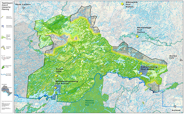
Enlarge Figure 2: Taashikaywin area of interest for planning
4.0 Desired outcomes for the Taa Shi Kay Win Land Use Plan
The Taa Shi Kay Win land use plan will provide goals, objectives, principles and direction that address the following land use subjects and outcomes:
- Traditional and Customary Use: Traditional and customary use information will be provided via both cultural inventory and input from the First Nations planning team members. Expected outcomes are:
- Documentation of information and knowledge
- Identification and protection of old grave sites and other sensitive traditional areas
- Principles to guide land and resource use decisions.
- Conservation and Protection: The two First Nation communities have lived with and on this land area for uncounted generations and view themselves as the custodians of it. They will lead the process that describes the conservation and protection measures for the area, working together with Ontario. Conservation and protection measures will take into account the objectives for planning expressed in the Far North Act including for protection of areas of cultural value and the protection of ecological systems, the maintenance of biodiversity, ecological processes and functions, including protection of species at risk and their habitat and the storage and sequestration of carbon. The expected conservation and protection outcomes for Taa Shi Kay Win are:
- Mapping of areas with high conservation/protection interest, including emphasis on areas of cultural importance and valued ecological systems
- Strategic direction regarding the areas and manner in which they must be conserved and/or protected
- Identification of areas and provision of management strategies for conservation and/or protection of their traditional and sustaining land base
- Identification of one or more protected areas (e.g., Dedicated Protected Areas, Parks or Conservation Reserves) based upon Aboriginal traditional knowledge, design principles, landform/vegetation complex representation, and additional analysis or tools provided by broad scale policy direction
- Recognition of existing protected areas (e.g., Albany River Park) and review within the planning process to determine potential recommendations concerning permitted uses and existing boundaries
- Recognition and respect for traditional uses protected by Aboriginal and treaty rights
- Provisions that will contribute to protection of Species at Risk, including woodland caribou, wolverine and lake sturgeon e.g. critical habitat protection.
- Forest Management (commercial forestry):
- Provision of Forest Resource Inventory to support planning decisions and future resource management planning
- Direction for areas desired and suitable for forest management
- Strategic level direction guiding the manner in which forestry is to proceed (with details to be determined through Environmental Assessment Act coverage and forest management planning).
- Forest Management (non-timber forest products):
- Provision of Forest Resource Inventory to support planning decisions and future resource management planning
- Direction for areas desired and suitable for non-timber forest management
- Strategic direction guiding the manner in which non-timber forest resource use is to proceed.
- Tourism (and Eco-tourism):
- Mapping of existing tourism operations
- Information on potential tourism opportunities
- Strategic direction guiding tourism as a land use
- Direction regarding overlapping uses/interests and the protection of tourism interests.
- Geoscience and the Mineral Sector (exploration and mining)
- Information relevant to mineral exploration and development (e.g., maps of bedrock geology / areas of significant mineral potential)
- Identification of existing mining claims
- Explanations of mineral exploration and development (the mining sequence) and the implications of Mining Act modernization for future activities
- Options for possible future mineral sector activities
- Information relevant to public health and safety; the current state of the environment; infrastructure needs; and economic opportunities (e.g., environmental base-line data, and maps of surficial geology / aggregate resources)
- Guidance for land use areas providing a balance of areas with access to mining sector opportunities and protected areas requiring withdrawal of mining sector activities.
- Recreation:
- Mapping of recreation potential and interests
- Strategic direction regarding the manner in which recreation interests will proceed
- Provision of land use areas supporting recreation activities.
- Water Conservation and Protection:
- Mapping of waterways and current and projected waterway developments (including, but not limited to hydroelectric power developments)
- Strategic direction regarding the manner in which water use interests will proceed
- Direction regarding overlapping uses/interests and the conservation and protection of water and waterways.
- Renewable Energy:
- Identification of potential and land use designations to support community and/or provincial interests in opportunities that may include hydroelectric power development (see water conservation and protection) and wind power.
- Access and Infrastructure:
- Mapping of existing access and infrastructure (e.g. transmission corridors)
- Recognition of overlapping, broader access and infrastructure initiatives
- Strategic direction guiding access and infrastructure interests
- Identification and safeguarding of the important relationships that exist between access and infrastructure and current and future land use.
- Climate Change:
- Consideration of opportunities to contribute to the adaptation to and mitigation of climate change, including the identification of areas that are important sources of carbon storage.
- Fire Management:
- An understanding of the relationship between the Ontario Fire Management Strategy and existing or proposed land use activities
- Land use direction and priorities for fire management (consideration of amendment(s) to the Ontario Fire Management Strategy may be needed).
5.0 Process and phases
A planning process has been designed to support the preparation of this land use plan, incorporating the principles of fairness, openness and respect. The planning partners of Mishkeegogamang First Nation, Eabametoong First Nation, and MNR will strive to reach consensus on recommendations, building from the information, input and opinion provided during consultation opportunities. The planning process will proceed with respect for Aboriginal and treaty rights.
In addition to preparing and organizing for planning, there are three formal planning phases. In all planning phases, community dialogue and meetings will take place as needed for communities to build consensus and determine readiness to move forward. As well, MNR will facilitate dialogue within the ministry and with other agencies as needed to build a provincial consensus to move forward in each phase. The planning phases are:
Phase 1: Winter 2009/spring 2013
- Prepare and approve Terms of Reference
- Assemble background information
- Prepare vision and goal statements
- Invitation to participate for adjacent communities
- Invitation to participate, sharing Terms, notification of process and public consultation opportunities on Environmental Registry posting and mail-outs
- 1st open houses and dialogue opportunities.
Phase 2: Fall/winter 2013/14
- Prepare objectives and opportunities analysis
- Continue dialogue with adjacent communities
- Confirm final planning area
- Prepare Draft Land Use Plan
- Notice of public consultation opportunities on Environmental Registry posting update and mail outs
- 2nd open houses and dialogue opportunities
- Recommend designation of confirmed planning area.
Phase 3: Spring/summer 2014
- Prepare summary of input received on Draft Plan
- Prepare Final Land Use Plan
- Recommend Final Land Use Plan for approval by the councils of Eabametoong and Mishkeegogamang First Nations and the Minister of Natural Resources
- Decision notice provided on Environmental Registry including summary of response to public input.
The planning process is supported by a decision-making framework of planning teams, a timeline and step-wise process and a number of protocols regarding information and liaison with various interests or agencies. Consultation is an essential element of the planning process.
Planning teams
The framework for planning includes a primary planning team and a planning support group:
- Primary Planning Team – community representatives of Eabametoong First Nation and Mishkeegogamang First Nation. Membership is composed of:
- Eabametoong First Nation – six members
- Mishkeegogamang First Nation – six members
- Project Management/Facilitation Consultant
- MNR/Far North Planners – Sioux Lookout District, Nipigon District
- MNR Far North Senior Planner – Northwest Region
- Planning Support Group (provides background and information support and services for the planning team). Membership is composed of:
- Eabametoong First Nation, project representative
- Mishkeegogamang First Nation, project representative
- Project Management/Facilitation Consultant
- MNR District representatives
- Sioux Lookout District, Area Supervisor
- Nipigon District, Area Supervisor
- Far North Planning Manager – Northwest Region
- MNDM Representatives –
- Northwest Regional Land Use Geologist
- Northwest Regional Manager
- MNR Natural Heritage Specialist, Northwest Region
Responsibilities
Eabametoong First Nation and Mishkeegogamang First Nation have planning responsibilities that include the following:
- Leading planning dialogue
- Supporting opportunity for community engagement in planning and decisions
- Facilitating the understanding of, information on, and direction for traditional use, traditional Aboriginal knowledge and cross-cultural dialogue with agencies, stakeholders and the public.
MNR has planning responsibilities including:
- Facilitating discussion on lands and resources capabilities
- Discussing integrated resource management principles
- Facilitating consultation opportunities in the context of community based land use planning. Ontario respects and will address its requirements for consultation with First Nations.
- Addressing policy and legislation requirements associated with the Far North Act.
MNDM has planning responsibilities including:
- Providing information related to geoscience, including mineral potential, in the planning area
- Describing the mining sequence, and identifying areas of past and current mineral sector activity
- Giving advice on using this data to identify areas that may have social or environmental implications, or offer economic opportunities
- Assessing proposals for land use designations.
Authority
The Far North Act identifies the requirements and authority for formal joint First Nation - Ontario approvals, including for:
- Terms of Reference; and
- Final Land Use Plan.
Joint approvals for each of the above are required by:
- Eabametoong First Nation Chief and Council;
- Mishkeegogamang First Nation Chief and Council; and
- Minister of Natural Resources.
Approval of the Final Plan will be by Minister’s Order under the Far North Act, 2010 and by First Nation Band Council Resolution from each First Nation.
Prior to seeking approval of the Final Plan, the planning team will request that the planning area be designated under the Far North Act via Minister’s Order.
These terms of reference can be amended if required, in accordance with the Far North Act.
The Eabametoong First Nation and Mishkeegogamang First Nation relationship to the lands and resources will continue and will be reaffirmed through this process.
Once a land use plan is in place, activities on the landscape must be consistent with the plan’s land use designations.
Following approval of the Community Based Land Use Plan, the planning partners will address community and provincial obligations required to implement direction and activities.
Dispute resolution
The land use planning process has been structured to incorporate on-going dialogue and feedback throughout the process. This offers a means to resolve issues and disputes concerning planning matters.
The approach to deliberate and offer solutions to resolve issues identified by parties external to the planning team or to resolve disagreements within the planning team, will be a step-wise process including a review of the issue by:
- The respective Chiefs of Mishkeegogamang and Eabametoong First Nations; and
- The respective District Managers of Sioux Lookout and Nipigon Districts.
A party bringing forward a dispute or issue shall provide it in writing, with a recommended solution. The Chief of each community will meet with the MNR District Managers to review and develop responses. A response may be expected within 30 days following the review of the dispute or issue.
Consultation
Consultation will be addressed by engaging all interested people and organizations in a dialogue on land use planning through a variety of mechanisms that include: meetings, environmental registry postings, open houses and mail outs. Initial efforts to invite consultation with other local First Nation communities, resource users (tourist operators, anglers, hunters, forest industry, mineral exploration/mining industry), government, municipalities and the general public having an interest in the planning area will occur by giving direct written notice of the intent to prepare this strategic land use direction.
People not included on the initial mailing list, but who wish to become involved in the planning process, will at their request have their names added to the mail out list.
A general Public Notice will be placed in the local newspapers including: Sioux Lookout Bulletin, Times Star Geraldton, Thunder Bay Chronicle-Journal and Wawatay Newspaper.
The land use plan will be a policy posting on the Environmental Bill of Rights (EBR) Environmental Registry, beginning with a proposal at the invitation to participate stage, updating at Draft Plan stage, and concluding with a decision upon approval of the Final Plan. Additionally, the Terms, Draft Plan and Final Plan will be posted on the Far North website.
After the mail outs are distributed, meetings will be held to provide information on each phase of the planning process and to solicit input into the land use plan. Comments and submissions will be collected and the requirements of the following pieces of legislation will be met: Far North Act, the Environmental Bill of Rights, and the Freedom of Information and Protection of Privacy Act. Advance notice of Open Houses will be mailed to all names on the mail out list. Documents that are produced through this planning exercise will be made available for public review and comment. A summary of comments will be available to the public at appropriate locations.
Open Houses will be held in both Eabametoong First Nation and Mishkeegogamang First Nation (including the Municipality of Pickle Lake) and Thunder Bay. These Open Houses will provide both local and regional access to the consultation opportunities.
Interim measures
The Far North Act provides for orderly development in the Far North. Under the Far North Act, Community Based Land Use Plans must be completed before most major development begins, including commercial timber harvest or opening a new mine. The Act does allow certain types of development to proceed in advance of a plan, provided certain criteria are met. A development may also be allowed to proceed if it is determined to be predominantly for community use or if it contributes directly to meeting community needs of the First Nations and takes into account the objectives of the Act.
While the Community Based Land Use Plan initiative is underway, MNR, and Mishkeegogamang and Eabametoong First Nations would expect that joint planning team input would be invited to the consideration of development proposals and that decisions would be consistent with the provisions of the Far North Act.
Information management
The planning process will require consideration of all available information to help support and inform joint planning discussions while respecting and protecting Indigenous Knowledge. A joint protocol between the community and MNR will be established that will outline what information will be brought forward by each party and how it will be used in the community based land use planning process.
All information provided by community members to support community input to the planning process (i.e., Aboriginal Traditional Knowledge) will remain with the community unless the community deems it shareable with the Province of Ontario.
Ontario will provide and support the planning team with its best available information and data, to be used for the purpose of community based land use planning.
In addition, the joint planning team will identify appropriate information management strategies for the information used to support the development of the CBLUP.
MNR will work with the joint planning team to ensure compliance with requirements for information under the authority of the Far North Act, Freedom of Information and Protection of Privacy Act and the Archives and Recordkeeping Act. Notices required for public consultation purposes under the Far North Act and the Environmental Bill of Rights will be the primary responsibility of the MNR. The subjects and results of all consultation will be considered by the planning team and incorporated into the planning process.
The joint planning team will oversee communications and delegate as required, including developing and ensuring public notices are submitted as required, compile the appropriate mailing list, initiate mail out of planning phase information, provide notice of meetings, and any other information deemed appropriate.
All formal input and comments received during the planning process will be documented and available as an official planning record. Copies of all formal input and comments received during the process will be provided to the joint planning team.
Contacts
Andy Yesno
Taashikaywin Liaison
Eabametoong First Nation
P.O. Box 298
Eabamet Lake, Ontario
P0T 1L0
David Masakeyash, Councilor
Taashikaywin Liaison
Mishkeegogamang First Nation
1-B First Nation Street, General Delivery
Mishkeegogamang, Ontario
P0V 2H0
Jill Entwistle
Far North Senior Planner,
Ministry of Natural Resources
Northwest Regional Office, Suite 221a
435 James Street South
Thunder Bay, Ontario
P7E 6S8
(807) 475-1776; e-mail jill.entwistle@ontario.ca