Pauingassi First Nation community based land use plan
A land use plan for the Pauingassi First Nation. It provides strategic direction to respect traditional and existing land uses while protecting the environment. It also identifies opportunities that can contribute to a stronger community economy.
62720
(0.04, P.R. 06 13 11)
ISBN 978-1-4435-6915-6 (Print)
ISBN 978-1-4435-6916-3 (PDF)
July 12, 2011
The Land of Fair Wind
Pauingassi First Nation and Ontario have reached an important milestone with the completion of a final Community Based Land Use Plan for the Pauingassi Ontario planning area. This accomplishment is the result of working together over several years in good faith and with mutualrespect. The foundation has been set to continue our working relationship throughout plan implementation.
Setting a course for the well-being of future generations, the plan affirms the importance of ongoing traditional use and the First Nation’s relationship to the land. Area dedications in the plan provide for protection of this outstanding landscape, while supporting the potential for sustainable economic development opportunities. In finding a balance, the plan will contribute to a stronger future for the community of Pauingassi.
In 2009, as this planning process was getting underway, Ontario introduced Bill 191, the Far North Act , to provide a for planning. We are now pleased to recognize our plan under the Far North Act , 2010, as approved by Pauingassi First Nation and Ontario. From this point forward, land use activities in the planning area must be consistent with the land use direction specified in this plan.
It is with sincere pleasure that we endorse the Pauingassi Community Based Land Use Plan, The Land of Fair Wind.
Honourable Linda Jeffrey
Minister of Natural Resources
by Minister’s Order
Far North Act 2010
Chief Harold Crow
Pauingassi First Nation
by Band Council Resolution
Preface
Pauingassi First Nation is an Ojibway-speaking community located in Manitoba, with areas of traditional use in both Manitoba and northwestern Ontario. Pauingassi has led the preparation of land use direction in a separate process with each province, in a manner that will provide seamless direction across provincial boundaries.
A primary reason for Pauingassi First Nation to engage in planning is to provide for the well being of future generations, documenting community priorities, desired land uses and opportunities, and strategic direction for the management of lands and resources.
This Pauingassi Community Based Land Use Plan addresses the area in Ontario defined by traplines held by Pauingassi community members. Pauingassi has worked together with Ontario to prepare this plan within the context of Ontario’s Far North Planning Initiative and the Far North Act 2010. Pauingassi notes that these planning areas do not necessarily define Pauingassi’s full self-described traditional land use area.
The plan has been created in good faith between Pauingassi First Nation and the Ontario Ministry of Natural Resources. Rooted in mutual faith and respect for both planning partners this plan provides guidance for future land use activities in the Pauingassi-Ontario Planning Area. Plan approval reflects a consensus among the community members and with the province. Implementation of this land use plan will continue to be guided by this good faith and mutual respect.
Acknowledgements
The Pauingassi Community Based Land Use Plan is the result of leadership, collaborative work and the support of many people - people in the community, people outside the community, people working with funding organizations, and with the province.
The plan was made possible through the leadership of Pauingassi First Nation Chief and Council, the guidance of Pauingassi Elders and the Pauingassi people who entrusted the planning team with the responsibility to develop a land use plan. The participation and support of the Ontario Ministry of Natural Resources and the Ontario Ministry of Northern Development, Mines and Forests is acknowledged. Red Lake District, Northwest Region, and advisors with Far North Branch and Ontario Parks all contributed to completion of the planning process. Funding support was provided by Ontario in association with Ontario’s Far North Planning Initiative.
And we appreciate the contribution of all people and organizations providing views, perspectives and advice, including those who have participated in consultation opportunities.
Plan summary
The Pauingassi Community Based Land Use has been produced by Pauingassi First Nation, working together with Ontario. This plan addresses trapline areas in Ontario held by Pauingassi, a Manitoba First Nation. Pauingassi is also working together with the province of Manitoba to produce a land use plan for the adjacent planning area in Manitoba.
Pauingassi has been working with Ontario Ministry of Natural Resources since 2004. Dialogue began with Pauingassi’s expression of interest in planning within the context of the community objectives and the 2002 Stewardship Accord (which led to initiation of the Pimachiowin Aki UNESCO World Heritage Site project). In 2009 Pauingassi employed community planning support workers who interviewed elders and other members of the community to document traditional land use and occupancy and identify cultural lands, values and ecological information, including detailed plant and animal information. Ontario contributed information on landforms, vegetation, fish and wildlife habitat, geology, and land use (existing and potential).
Terms of Reference were signed in 2009 to guide the formal three-year planning process. The Pauingassi-Ontario planning area (138,763 hectares) was described in the Terms of Reference and confirmed through the planning process.
Throughout the process, the joint Pauingassi-Ontario Ministry of Natural Resources planning team engaged in regular dialogue, analyzed information and sought advice. In 2010, a draft plan was produced with proposals for land use areas and strategic direction to address the goals, objectives, and principles set out by Pauingassi and Ontario (including emerging direction with the Ontario Far North Planning Initiative). The draft plan was the subject of consultation within the community, then was publicly shared in the Fall of 2010 for consideration by all interested people and organizations.
The final plan (The Pauingassi Community Based Land Use Plan 2011) is approved by Pauingassi First Nation and Ontario. This plan provides strategic direction to respect traditional and other existing land uses and to protect the environment. Furthermore, this plan identifies opportunities that can contribute to a stronger community economy. Direction in the plan has considered the significant cultural and ecological features, land uses and land use designations for areas in Ontario adjacent to the planning area.
Two land use areas are defined, one designated as a protected area and one designated as an enhanced management area. The plan identifies the development, land uses and activities that are permitted or not permitted in each area. In both land use areas, waterways are highlighted as they are particularly important for traditional use and natural heritage conservation, and have the potential to enhance recreation and tourism opportunities.
During plan implementation, Ontario shares Pauingassi’s interest in exploring arrangements to continue working together in the management of lands and resources. Pauingassi’s Community Based Land Use Plan is expected to inform the submission of the ‘Pimachiowin Aki’ UNESCO World Heritage Site nomination by providing land use direction and certainty for land use.
A review of the plan will take place once every 15 years, with the first review scheduled for 2026.
Pauingassi Dedicated Protected Area (108,493 ha):
This land use area supports protection of lands and waters, continued traditional use, existing and new tourism opportunities, and inclusion in the Pimachiowin-Aki World Heritage Site nomination. The intent is to regulate the Dedicated Protected Area as a protected area, although the specific designation and category are yet to be determined. The type of protected area and regulatory mechanism will be determined jointly by Pauingassi and Ontario following approval of the plan.
Aboriginal traditional activities protected by Aboriginal and treaty rights including (but not limited to) hunting, trapping, fishing, and gathering are ongoing and will continue to be managed by Pauingassi First Nation. Direction is provided for other land use activities.
The plan notes that the direction for other permitted uses is subject to confirmation in future management planning.
Other permitted uses:
- Travel by motorized boat, snow machine, all terrain vehicle (ATV), or airplane.
- Recreational sport fishing, hunting, research/education
- Commercial fur harvesting, commercial fishing, commercial non timber forest products, commercial tourism, wild rice harvesting.
Excluded uses:
- commercial forestry, mineral exploration, mining, commercial power generation development (hydroelectric transmission or generation, wind power), new energy transmission and communication corridors, commercial bait fishing
- road building, aggregate extraction, peat extraction.
Cherrington Lake Enhanced Management Area - cultural heritage category (30,270 ha):
This land use area supports protection of lands and waters, continued traditional use and existing and new tourism opportunities while permitting specific activities associated with potential economic development opportunities in areas having provincially significant mineral potential.
Aboriginal traditional activities protected by Aboriginal and treaty rights which include (but are not limited to) hunting, trapping, fishing, and gathering are ongoing and will continue to be managed by Pauingassi First Nation. The following direction is provided for other land use activities in the Cherrington Lake Enhanced Management Area:
Other permitted uses:
- Mineral exploration and development
- Travel by motorized boat, snow machine, all terrain vehicle (ATV), airplane
- Recreational sport fishing, hunting, research/education,
- Commercial fur harvesting, commercial fishing, commercial tourism, wild rice harvesting, commercial non timber forest products.
- Aggregate extraction is permitted for site specific needs associated with the mineral sector; extraction for export of aggregate beyond the area is not permitted; natural features are to be maintained.
- Roads are generally discouraged, but are permitted within the area if required to access mineral sector opportunities. The number of roads will be minimized. Roads would be developed in a manner that seeks to retain the integrity of the cultural and natural features and high quality remote tourism operations.
- Energy and transmission corridors are generally discouraged, but are if required to support advanced mineral sector opportunities.
Excluded uses:
- Commercial forestry
- Peat extraction
- Commercial bait fishing
Part A: Purpose and process
A.1. Introduction
Pauingassi First Nation is an Ojibway (Saulteaux) speaking community located 270 km northeast of Winnipeg. According to the regional May 2010 population statistics Pauingassi has an on reserve population of 550 and an off-reserve population of 40. Pauingassi people have managed and protected lands and resources for centuries, for spiritual and cultural practices and traditional livelihood activities including fishing, hunting and trapping.
It is through the creation of a Community Based Land Use Plan (CBLUP) that Pauingassi First Nation and Ontario are working to address protection needs and support the growth of a healthy and sustainable economy for both the community and the province by defining opportunities associated with lands and resources.
Pauingassi First Nation (Pauingassi) has been working with the Ontario Ministry of Natural Resources (OMNR) since 2004. Dialogue began with Pauingassi’s expression of interest in planning. In 2009, Pauingassi and OMNR reached consensus on and approved a Terms of Reference for preparation of a Community Based Land Use Plan. The formal planning process took two years, moving forward within the context of community objectives, the objectives of the Pimachiowin Aki UNESCO World Heritage Site initiative, and the objectives of the Ontario Far North Planning Initiative. An additional discussion of this planning context and relationships follows:
- Pauingassi has a close relationship based on historical and family ties with the adjacent community to the south, Little Grand Rapids First Nation. Both communities expressed interest in land use planning. The communities determined that planning would be undertaken separately by each community, in concurrent processes. The communities have worked closely to share information and planning dialogue, and make the most efficient use of travel and meeting arrangements.
- Pauingassi is one of 7 partners (5 First Nation Communities and two provincial governments) associated with the UNESCO World Heritage Site (WHS) nomination. The signing of the Stewardship Accord in March 2002 by Poplar River, Pauingassi, Little Grand Rapids and Pikangikum First Nations affirmed land use planning as a key component of the World Heritage Site nomination. Called Pimachiown Aki (the land that gives life), the site was placed on the Canada’s tentative list in 2004. Preparing land use direction in partnership with the associated provincial agencies (Ontario and Manitoba) will lead to formal implementation of land use designations, contribute to a strong submission and further illustrate the collaborative nature of the WHS proposal.
- When Pauingassi and OMNR began a dialogue on planning in 2004, Community-based Land Use Planning was Ontario’s policy for planning (in association with the Northern Boreal Initiative). As planning advanced, the planning team took into account emerging direction with Ontario’s Far North Land Use Planning Initiative, the introduction of Bill 191 in 2009, and approval of the Far North Act , 2010. The Pauingassi Community Based Land Use Plan is now approved as a plan under the Ontario Far North Act 2010, having taken into account the objectives of the Far North Act and met the requirements for planning.
- Pauingassi is also working together with the province of Manitoba to produce a land use plan for the adjacent planning area in Manitoba. Ontario and Manitoba have an ongoing dialogue to support planning in a manner that will lead to seamless and complementary zoning and direction across the provincial boundary.
Consultation opportunities have been provided during the planning process supporting engagement in planning by Pauingassi community members, adjacent First Nations in Ontario and all interested people and parties in Ontario.
This plan defines land use areas and strategic direction, adding to the existing framework for land and resource management in the planning area. In itself, the plan does not alter existing authority, nor does it confer new authorities. Pauingassi First Nation’s relationship to the land and traditional uses will continue and are reaffirmed through the planning process. The Far North Act 2010 (Section 14 (1)) describes that once a community based land use plan is approved, decisions respecting the allocation, disposition or use of public land and natural resources in the area must be consistent with the land use designations and permitted uses specified in the plan and the permitted uses prescribed for the purpose of the plan.
It is hoped that this land use plan will convey a sense of the people and the land. Pauingassi encourages people within and outside the community to read the plan in full, and Pauingassi welcomes dialogue at any time to share perspectives, build partnerships and understanding.
The next section, Part A.2, provides the guiding direction statements expressed as vision, goals, objectives and principles.
A.2. Guiding direction – Vision, goals, objectives and principles
Guiding direction statements were prepared to address both preparation and implementation of the land use plan. Statements are informed by Pauingassi’s historical and contemporary relationship to the land, and by provincial goals and objectives.
The Vision, Goals and Objectives were set out in the Terms of Reference and confirmed through the first consultation opportunities in November 2009. A set of principles are also described as they express underlying values to guide both preparation and implementation of the plan.
The directional statements are presented on the following two pages.
Vision
Pauingassi’s vision statement clearly communicates a picture of the future based on the relationship of its people to this area and the need to sustain this relationship for future generations.
Pauingassi First Nation – Vision statement
The people of Pauingassi First Nation have been part of the land from time immemorial (as long as the oldest elder of our community remembers). We believe and assert that we are part of the land. Our vision for the land is very much a vision for (of) ourselves. We wish to (use) manage our traditional land (in a way) so that our people as (being) part of the land are sustained into the future. For that purpose we are engaged in the steps needed to arrive at a land use plan for our traditional land in both Manitoba and Ontario.
The planning team adopted a joint Vision Statement (between Pauingassi First Nation and Ontario) expressing the commitment to continue working together in a positive relationship for implementation of the plan:
The people of Pauingassi First Nation and Ontario value their ongoing relationship, working together for the benefit and health of people, lands and waters.
Goals
The plan seeks to achieve the following goals:
- Strive to sustain and protect the natural world for present and future generations;
- Identify environmentally sustainable economic developments pursuant to the strategic land use direction;
- Pauingassi seeks to contribute to management of this planning area as it is a portion of Pauingassi’s traditional land use area, in which land use can support an improved community economy, training, and jobs for our people, while keeping the health of our traditional land;
- Support and sustain Pauingassi traditional knowledge, traditional land uses, and access to these lands now and for future generations; and
- Pauingassi First Nation will uphold and sustain our sovereign rights, both under Canada’s Constitution, including Section 35, and our rights under Treaty 5, while planning for this traditional land use area and the future of our community.
Objectives
The plan provides direction supporting achievement of the goals by addressing the following objectives:
- Prepare a land use strategy that is also a communication plan to share information about the relationship of the people of Pauingassi First Nations in all its aspects with their land so that it is understood and sustained;
- Support continued use of traditional lands and traditional uses in both a historical and contemporary context;
- Record and share traditional knowledge;
- Identify opportunities that are desired and compatible with this area;
- Harmonize objectives of Pauingassi and OMNR in land use and natural resource management;
- Determine protection zones and other land use designations;
- Take into account Ontario’s broader policy direction and Far North objectives for planning;
- Ensure local planning decisions do not preclude broader scale options development.
Principles
The following principles express underlying values to guide both preparation and implementation of the plan:
- Pauingassi First Nation has a duty and interest to protect and manage this land for future generations.
- Protect, respect and celebrate sacred and ancestral places and values
- Pauingassi First Nation respects the historical and continued shared use of its traditional territory by neighbouring communities for traditional activities of; hunting, fishing, gathering, travel etc. There has always been overlap in traditional use areas between communities.
- Recognize the area as it is part of the northern boreal forest and its ecological processes that have shaped the landscape for millennia.
- Recognize that the continuous flow of water beyond and through this land is vital to the land and its people. Protection of water sources is of the highest importance, as is management and protection of lakes and river corridors.
Additional sources of direction for OMNR’s engagement in the preparation and implementation of the land use plan include:
- OMNR Community-based Land Use Planning policy (2002);
- Our Sustainable Future (2005) and Our Sustainable Future: A Renewed Call to Action (April 2011) which outlines OMNR’s vision of sustainable development and the mission of ecological sustainability, and establishes a commitment to the conservation of biodiversity;
- OMNR’s Statement of Environmental Values under the Ontario Bill of Rights; and
- Ontario’s Far North Planning Initiative (2008) and the Far North Act 2010 provide direction on policy and planning. The objectives for land use planning in the Far North are provided in the Far North Act 2010:
- A significant role for First Nations in planning.
- The protection of areas of cultural value in the Far North and the protection of ecological systems in the Far North by including at least 225,000 square kilometres of the Far North in an interconnected network of protected areas designated in community based land use plans.
- The maintenance of biological diversity, ecological processes and ecological functions, including the storage and sequestration of carbon in the Far North.
- Enabling sustainable economic development that benefits the First Nations.
A.3. Land use planning area
3.1 Definition of the area
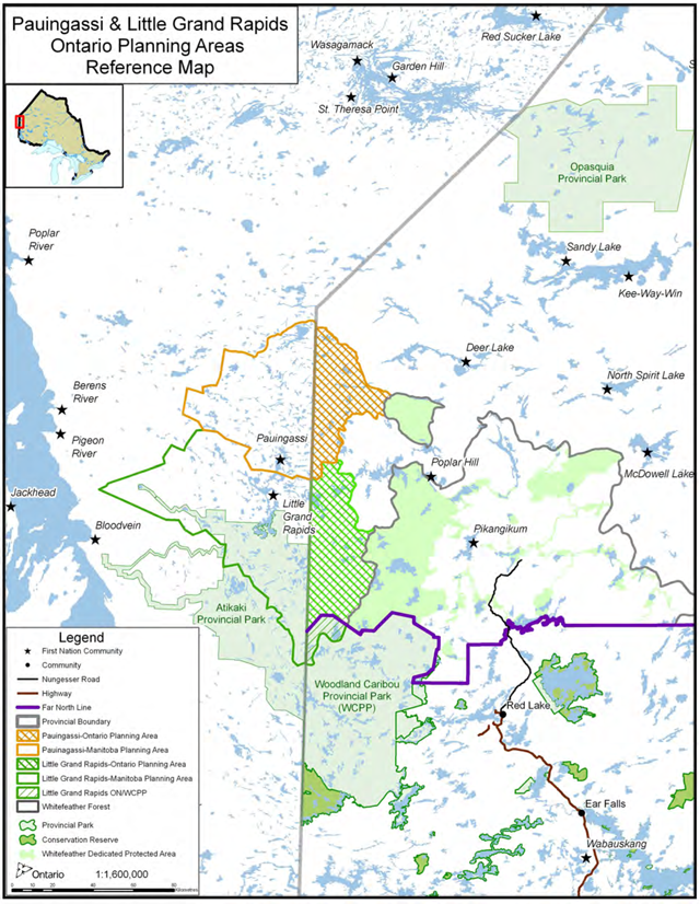
The planning area is 138,763 ha in the Far North of Ontario (See Figure 1). This area has been defined as the portion of Pauingassi First Nation’s self-described traditional territory that falls within the Far North of Ontario, defined by traplines held by the people of Pauingassi, whose relationship to the province of Ontario is established through Treaty #5 and the Constitution. Traplines do not necessarily represent the complete historical land use and occupancy by the people of Pauingassi First Nation, however, for the purpose of the land use plan, traplines provided a reasonable approach to map the planning area with respect for neighbouring communities.
3.2 Adjacent areas
The Pauingassi-Ontario planning area is northwest of the area defined as the Whitefeather Forest, north of the Little Grand Rapids-Ontario Planning Area and south and west of the trapline areas of St. Theresa Point, Deer Lake, Pikangikum and Poplar Hill. Other planning and administrative boundaries which are directly relevant to this initiative are noted in Figure 1 and include: Ontario’s Far North, Woodland Caribou Signature Site and the Manitoba border. The surrounding communities of Red Lake, Poplar Hill First Nation, Pikangikum First Nation, Deer Lake and St. Theresa Point First Nations are also noted in Figure 1.
3.3 Adjacent First Nations' ahared areas of interest
Pauingassi First Nation recognizes that the Pauingassi-Ontario planning area may include areas of ongoing traditional use by other First Nation(s); these areas are referred to as 'shared areas'. First Nations honour and respect these customary relationships with the land and with each other.
During the preparation of this plan, Pauingassi First Nation and the adjacent First Nations of Little Grand Rapids, Deer Lake, Poplar Hill, Pikangikum and St. Theresa have discussed their relationship to the planning area and interests in land use direction. In plan implementation, the First Nations will continue to discuss common interests consistent with the customary relationship between/among communities. Similarly, Pauingassi is engaged in a dialogue with other communities when they are leading preparation of a land use plan.
Deer Lake First Nation describes a particular shared interest involving the historical and present day travel of community members to the Cherrington Lake area, to hunt, fish and pursue other traditional activities. Pauingassi and Deer Lake may choose to describe a protocol to support future dialogue for the Cherrington Lake area.
3.4 Description of the Pauingassi-Ontario planning area
The next sections describe culture and history, land use, and land and resource characteristics.
3.4.1 Culture and history
The culture and history of this area is primarily informed by the relationship of Pauingassi people to the land. Historical use of the land includes Pauingassi’s customary land uses and use of travel routes to access traplines and activities carried out along the way such as camping, making fires, tea breaks, rests, berry picking, fishing, and hunting. Cultural features on the landscape such as pictographs, burial and ceremonial sites have been mapped and documented as having both historical and current relevance to the people of Pauingassi.
3.4.2 Current Pauingassi First Nation land uses
In the present day, Pauingassi First Nation members spend time on the land doing a variety of ongoing customary activities outside the community site. Customary land uses include traditional pursuits protected by Aboriginal and treaty rights (including but not limited to trapping, hunting, fishing) and other historical livelihood activities carried out in a traditional and/or contemporary manner. Activities include, but are not limited to:
- hunting and fishing (personal and shared use), commercial fishing, trapping (personal and shared community use; licensed, non licensed);
- use of travel routes to travel to traplines and activities carried out along the way such as camping, making fires, tea breaks, rests, berry picking, fishing, and hunting;
- travel by canoe, boat, motorized vehicles, snowmobile, plane, and floatplane;
- guiding, camping, staying in cabins;
- gathering medicinal plants (personal and shared use) and gathering non-timber forest products (e.g. berries, herbs, mushrooms – for personal and shared use);
- cutting firewood;
- swimming in lakes and rivers;
- sacred sites/ceremonial sites;
- wild rice harvest (for personal use); and
- ceremonies, events, gatherings.
First Nation communities adjacent or near to this planning area note that their community members also spend time in this area pursuing traditional activities. Deer Lake First Nation members in particular share an interest in the Cherrington Lake land use area. Traditional land uses of Deer Lake members include traditional pursuits protected by Aboriginal and treaty rights including but not limited to the activities listed above.
Caribou hunts are rarely planned and usually occur by chance. Moose are preferred as a food source because of the reliability of hunting success and the large quantity of meat that is obtained. The products of the kill are generally shared with members of the hunting parties’ families.
3.4.3 Other land uses and tenure (existing and/or historical)
Tourism
There are six remote outposts on five lakes. OMNR has identified that there are additional lakes that could support recreational fishing and hunting in new tourism opportunities, including Namiwan Lake and one unnamed lake west of Orono Lake. There are several boat caches in the planning area.There are 3 licensed bear management areas (areas of Crown land where bear hunting is regulated). These areas typically have potential bear habitat, and tourist outfitters or guides licensed to hunt bear.
Recreation
Several waterways support ongoing recreational use for community members (pursuing cultural and/or traditional activities) and for the public (e.g., canoeing, camping). The Bradburn and Poplar River waterways flow through the Pauingassi-Ontario planning area and are part of the Lake Winnipeg watershed. The Cherrington and Black Birch Lake areas, part of the Severn River watershed, are important waterways for both Pauingassi and Deer Lake First Nations.
3.4.4 Lands and resources
The lands and resources are described under the following headings: water and wetlands, geology, climate, forests, fish, birds, waterfowl, reptiles and wildlife.
Water, wetlands
Waters are vital to First Nation communities that have existed here for thousands of years, depending on waters for fishing, travel, wild rice plantations, and drinking water. Healthy rivers and lakes are a cultural and spiritual necessity for First Nation communities.
The planning area is characterized by its many lakes, rivers, streams and rapids. Low falls occur where there are bedrock outcrops along rivers and streams. The planning area is notable for having a secondary watershed divide in the northern portion of the planning area: north of the divide, water flows into the Severn River watershed; and south of the divide, water flows into the Lake Winnipeg watershed. Wetlands and lakes located in close proximity to the watershed divide such asCherrington Lake and Black Birch Lake are headwaters, having an important role as source water.
Geology
The geology of the planning area can be divided into bedrock and surficial components:
- Bedrock geology is dominated by 2.7 to 3 billion year old rocks of the Canadian Shield composed of granite, gneisses, and ancient volcanic rocks (e.g. basalt, gabbro). Located west of the traditional territory is a younger geological formation of 400 to 500 million-year-old rocks composed of limestone and sandstone. A greenstone belt is found in the northern portion of the planning area, near Cherrington Lake.
- Surficial geology can be generally described by:
- Organic deposits found in bogs, fens, and swamp areas where organic (plant) material settles. Organic deposits include peat, muck, and some inorganic sediment;
- ‘Undivided’ rock with minor Quaternary deposits from about 1.8 million years ago to the present;
- Till Veneer as a thin layer of till that is not continuous over the landscape and may include areas of rock outcrop. Till is sediment, generally consisting of well-compacted material that is layered and contains a mixture of sand, silt, and clay particles and coarse fragments; and
- Fine grained (glacio) lacustrine sediments generally consist of layered fine sand, silt, and clay deposited on an ancient lakebed, near lakeshore, or on a beach.
Climate
The Pauingassi-Ontario planning area falls within the Sub Humid Mid-Boreal Eco Climactic Region, with its climate classified as continental. It is characterized as cold to moderately cold and snowy during the winter and warm and moist during the summer. The area is influenced by weather systems originating over the land to west, north and south. Climate of the area is also modified by the maritime influences of Hudson Bay, Lake Superior and Lake Winnipeg which exert a moderating influence on temperatures and increase humidity.
This area experiences a warm summer with mean temperatures of 14°C and cold winters with a mean temperature of -14.5°C. Mean annual temperature is -0.4C and the average frost-free period ranges from 80-120 days. The region is considered to be sub humid to humid with 400 to 460 mm of precipitation. The growing season is between 130 and 170 days.
Forests
The Pauingassi–Ontario planning area is situated entirely in the Boreal Forest Region. The forest is conifer dominated with areas of deciduous forest occurring in areas of deeper soils. Tree species commonly encountered are black spruce, jack pine, white birch, balsam poplar and trembling aspen.
Fish
Walleye, sauger, perch, northern pike, whitefish and lake trout can be found throughout the Pauingassi-Ontario planning area. Subsistence fishing with gillnets and recreational fishing for these species continues to be important activities for the people of Pauingassi.
Birds, waterfowl and reptiles
Bird species include the spruce grouse, herring gull, double-crested cormorant, bald eagle, osprey, great horned owl, red-tailed hawk, sharp-tailed grouse, willow ptarmigan, common nighthawk, Canada warbler, olive-sided flycatcher, raven, gray jay, hawk owl, among others. Geese, ducks and other waterfowl are seasonally hunted. Bald eagles are considered sacred and their locations are noted. Bird species in the Pauingassi-Ontario planning area classified under the Endangered Species Act (2007) are: golden eagle (Endangered), and the whip-poor-will and American white pelican (Threatened); bald eagle, short eared owl, common nighthawk , Canada warbler and olive-sided flycatcher (all Species of Special Concern).
Snapping turtles are also present in the planning area. Snapping turtles are classified under the Endangered Species Act (2007) as a Species of Special Concern.
Wildlife
Wildlife typical of this area include wolf, lynx, ermine, fisher, mink, moose, black bear, woodland caribou, red squirrel, snowshoe hare, lynx, wolverine, fisher, otter, pine marten, beaver, short-tailed weasel, red-backed vole, and least chipmunk.
Prominent mammals are moose and woodland caribou. Beaver and muskrat not only provide valuable furs, but also good meat or eating, as do rabbits and “bush chickens” (spruce grouse in particular). Otters, bear, wolf, fox, mink, fisher, ermine, squirrel and marten are trapped for their furs.
Wildlife species in the planning area that are classified under the Endangered Species Act,(2007) are: woodland caribou and wolverine (both classified as threatened). Mountain lion (or cougar) (classified as Endangered) may also be present in this area.
A.4. Process and consultation
Process and consultation requirements were set out in the Terms of Reference and have been followed, with timelines revised as necessary. Four phases were addressed to complete the final land use plan over a 2-3 year timeframe. The first two phases were combined to provide sufficient information to support a meaningful consultation opportunity. Key components of each phase with updated timelines are:
Phase 1 & 2 - Fall/winter 2008/09
- Terms of Reference were endorsed on April 24, 2009.
- An Ontario Environmental Bill of Rights Environmental Registry policy proposal for the Pauingassi Community Based Land Use Plan was posted on October 16, 2009 (010-7334).
- Background information was assembled and interests and opportunities were identified.
- Pauingassi led dialogue within the Pauingassi community and with adjacent First Nation communities.
- Public consultation opportunities were provided in meetings and at open houses in Red Lake, Little Grand Rapids, and Pauingassi.
Phase 3 - Spring to fall 2010
- A Draft Plan was produced with proposed zoning and direction for activities, then shared broadly to seek input and build consensus on proposals.
- Environmental Registry posting 010-7334 was updated to provide the Draft Plan and information on consultation opportunities, including notice of open houses.
- An Environmental Registry policy proposal was posted (011-1601) addressing a proposed major amendment to the Crown Land Use Policy Atlas to incorporate the direction of the Pauingassi Draft Plan.
- Public consultation opportunities were provided in meetings and open houses in Red Lake, Little Grand Rapids and Pauingassi.
Phase 4 - Winter 2011
- The Final Plan was produced, considering comments from Phase 3.
- Endorsements proceeded through approval processes (First Nation and OMNR) reflecting a consensus on the land use plan.
- Environmental Registry decision notices for the Final Plan and the major amendment to the Crown Land Use Policy Atlas were posted.
Consultation
In this planning process, consultation opportunities are designed to provide for engagement and input by:
- Pauingassi First Nation community members;
- adjacent First Nations; and
- the Ontario public at large, interested parties and stakeholders.
A description of consultation opportunities is provided on the next two pages.
Pauingassi community consultation:
Pauingassi led consultation within the community, providing opportunities designed to encourage members to become involved and express their views and interests. Community members have also supported the planning dialogue by mapping and sharing their understanding of traditional knowledge, complementing existing information and science. Throughout 2009, interviews were held with elders and other members of the community to collect traditional land use and occupancy information.
In addition to regular dialogue on planning within the community, led by the Community Planning
Co-ordinator, two open houses and an information session were held in Pauingassi:
- On November 5th 2009 an open house was held to share the Terms of Reference, background information and analysis of capabilities and opportunities. Approximately 30 people from Pauingassi attended the community open house.
- On October 4th 2010 a second open house was held to share and discuss the proposals in the Draft Land Use Plan. Approximately 20 people from Pauingassi attended the community open house.
- On May 10th, 2011 an information session was held to share and discuss the land use plan prior to sign off. Twenty-six people from Pauingassi attended the community information session.
Pauingassi’s approval of the plan reflects a community consensus.
Adjacent community consultation:
Pauingassi led consultation with adjacent First Nations, including:
- In 2009, individuals from Pikangikum, Deer Lake, Poplar Hill and Little Grand Rapids attended the first open house in Red Lake.
- In 2010, Pauingassi met with the communities of Deer Lake, St. Theresa and Poplar Hill to discuss the Draft Plan and proposed land use designations.
- In 2010, individuals from Pikangikum, Poplar Hill and Deer Lake attended the second open house in Red Lake to view the Draft Plan.
- In 2011, Pauingassi met with individuals from Deer Lake and St. Theresa to discuss land use plan direction and reach shared understandings.
- In 2011, Pauingassi presented material on their plan to a Northern Chiefs tribal council workshop.
Public consultation:
Pauingassi and OMNR facilitated an open, consultative process to provide all interested people and organizations with the opportunity to participate, become familiar with proposals and provide input. Invitations to participate were distributed broadly, including to resource sector contacts and organizations, ENGOs, Municipality of Red Lake and local citizens, First Nations and tribal councils. Consultation opportunities were provided by:
- Notice of the project and consultation opportunities by newspaper, mail, and phone calls;
- Notice of the planning team contact information;
- Sharing of documents electronically and on request;
- Environmental Bill of Rights - Environmental Registry Policy Proposal notice 010-7334:
- Posted October 16, 2009 for a 45-day comment period at the Invitation to Participate, Terms of Reference and Objectives and Opportunities stage;
- Republished November 23, 2010 to provide for a 45-day comment period at the Draft Plan stage;
- Environmental Bill of Rights - Environmental Registry Policy Proposal notice 011-1601 posted concurrently with the Draft Plan, addressing a proposed major amendment to the Crown Land Use Policy Atlas to incorporate the direction of the Pauingassi Plan:
- Open house events in Red Lake were held at two progress points:
- November 3, 2009 to view information, contribute information and to ask questions of the planning team regarding the planning process and expected outcomes.
- December 9, 2010, to share the Draft Plan and invite comment on proposals for land use areas and strategic direction.
- Prior to the second open house an information session was offered for the following sector groups; Mineral Sector, Tourism, and Environmental Non-Government Organizations. Representatives of the tourism sector participated.
A summary of the consultation undertaken with this project is on record and available at the Red Lake District Office. A summary of the effect of consultation input on preparation of the plan is available on the Environmental Registry, EBR Registry Number 010-7334.
There were no responses provided to the Environmental Registry posting 010-7334. Comments provided to the planning team at open house events were verbal. Key messages provided verbally included support for Pauingassi’s planning process and interest in the plan development.
A.5. Information summary
Information from all sources supported the planning process. Primary information sources were
Pauingassi, OMNR and the Ministry of Northern Development of Mines and Forests (MNDMF):
- Pauingassi adopted a data collection program to support development of the plan. Local individuals were trained in indigenous data collection, documenting the land uses and occupancy of the Pauingassi First Nation members for the planning area and beyond. Indigenous data collection addressed cultural lands, values and ecological information as well as detailed plant and animal information.
- OMNR provided information on landforms and vegetation interpreted from satellite mapping, as well as the results of field surveys (e.g. fish and wildlife surveys) and available analysis of recreation potential, hydro potential and provincially significant natural heritage features. During the planning process, proposed protected areas were evaluated for their representation of landform/vegetation complexes and enduring features.
- MNDMF provided information on the bedrock and surficial geology of the planning area, including evaluation of areas of mineral potential and historical records.
A full data and map list, with sources of information is available on request. A summary of mapped information follows:
Cultural values:
Pauingassi has mapped locations and areas that the families of Pauingassi First Nation members have used for generations for fishing, trapping and hunting, and trap line areas. Cultural values information is held by Pauingassi and not provided on publicly-shared maps. With interpretation by Pauingassi, cultural values information supports decision making in the planning process.
Deer Lake First Nation has also provided cultural values information for the Cherrington Lake area to support decision making. The Deer Lake people have used this area traditionally for many generations.
Natural heritage:
Maps identify eco-regions, fire history (year and location of fires across the region), caribou and wolverine distribution, watersheds, landcover, and areas of provincial interest for the protection of natural heritage landforms and features.
Provincially Significant Mineral Potential (PSMP):
MNDMF conducted a PSMP study of the planning area to assist with definition of land use areas and designations. In a PSMP study, a qualified Professional Geologist uses all available geoscientific information to assess an area to quantify the likelihood of finding an economic mineral resource that could reasonably add value to Ontario’s economy. The Ontario Geological Survey Open File Report 6141 (2008) sets out the methodology.
MNDMF’s PSMP analysis identified an area of generally greenstone-hosted terrain in the Cherrington Lake area having significant mineral potential that can support mineral exploration and potentially, mining opportunities. The remainder of the planning area is described to have low mineral potential based on existing information.
Recreation and tourism map:
Identifies location of cottages, outposts, boat caches and potential outpost lakes.
Land tenure map:
Identifies Bear Management Areas and wild rice licence areas.
Part B: Land use plan zoning
The Pauingassi Community Based Land Use Plan provides direction for the future. The plan supports the achievement of community and provincial objectives by providing certainty for activities and by providing guidance for subsequent resource management and decision-making. The plan takes into consideration local and broad scale contexts, implications for and linkages with adjacent communities and existing land uses and plans.
Part B presents the land use plan zoning, describing:
- Preparing plan direction;
- Achieving goals and objectives;
- Zoning (land use areas, land use intent and activities for each area); and
- Strategic direction (all activities; specific activities and management of lands and resources).
B.1. Preparing plan direction
The joint planning team was entrusted with the responsibility of preparing direction to achieve goals and objectives, guided by the community and the province, and considering consultation input. Initially, the planning team developed an understanding of the process, information and planning tools, in which:
- zoning maps land use areas where land use activities are both desirable and compatible;
- strategic direction guides the manner in which activities should take place during implementation of the plan; and
- existing policy and subsequent planning processes (e.g., resource management planning, environmental assessment) also support achievement of objectives.
With that understanding, the planning team proceeded to:
- assemble information describing the planning area’s land and resource capabilities;
- map sensitive and vulnerable areas;
- identify possible activities and economic development opportunities;
- map locations suitable for activities and describes any potential conflicts;
- assign areas to a land use designation supporting those desired and compatible activities
- (dedicated protected area, enhanced management area, general use area); and
- describe strategic direction and implementation actions to achieve opportunities.
A consensus-based decision making approach was followed, including consideration of all input from engagement and consultation opportunities. The planning process relied on a positive open dialogue and engagement of the community, including advice from Pauingassi Elders and Trappers. The best available information supported decision making, including recorded and mapped Aboriginal traditional knowledge and the information and expertise brought forward by provincial agencies, OMNR and MNDMF.
The planning team provided direction in accordance with an emphasis on protection, to support ongoing traditional use, tourism activities and achievement of potential opportunities in the Pimachiowin Aki World Heritage Site nomination. Waterways were highlighted as notable landscape features supporting traditional use, tourism, recreational use. Future resource management and activities planning will continue to emphasize protection of these waterway features.
Information brought to the process from MNDMF identified a greenstone belt in the northern portion of the planning area (referred to as the Cherrington Lake area). Consistent with the objective to support economic development opportunities, it was recommended that this opportunity for mineral sector activities be kept available, while providing measures to protect the Cherrington Lake waterbody. Cherrington Lake is a headwater lake of the Severn River watershed, and has importance for Deer Lake First Nation as an area of traditional use and source water. The lake supports a lake trout population and woodland caribou habitat and is the location of several tourism operations.
B.2. Addressing goals and objectives
The plan and its implementation will contribute to the achievement of the shared goals and objectives of Pauingassi and Ontario in the following manner:
- Pauingassi First Nation has had a significant role in planning, leading the planning process contributing Pauingassi Aboriginal Traditional Knowledge and guidance, and working together with Ontario;
- The plan contributes to Pauingassi First Nation’s objective of achieving a linked network of protected areas that supports the UNESCO World Heritage Site proposal
Pimachiowin Aki
; - The planning area’s natural heritage and cultural values are highlighted, and protected.
- Protection of life on the land will support the sustainability of the provisions of the land such as medicinal plants and the harmony of people and the land.
- Opportunities for pursuit of economic developments are highlighted in this plan and also through the WHS proposal, including protected area management, tourism, NTFP, recreation, mineral exploration, research and education. Pauingassi’s interests in
- opportunities that may be associated with increased tourism and job creation are recognized.
- The Pauingassi Enhanced Management Area is designed to support economic opportunities that may be associated with a greenstone belt while protecting watershed characteristics.
- The Pauingassi Dedicated Protected Area contributes to achievement of a connected, contiguous protected area of over a million hectares supporting the interconnection of protected areas. (Woodland Caribou Provincial Park, Atikaki Wilderness Park, Lake Country),
- The plan supports protection of habitat for species at risk including summer and wintering habitat and calving areas for woodland caribou throughout the entire planning area. This landscape (planning area) is represented predominately by young jack pine and black spruce forest mix on a bedrock plateau interspersed with some large tracts of mature conifer forest. The conifer dominated forest will continue to provide valuable wintering habitat potential consistent with woodland caribou’s life history strategies that are well adapted to large scale disturbances. Interconnection of the Pauingassi-Ontario protected area within the larger complex of protected areas will also contribute to support the needs of woodland caribou in the area, providing travel corridors and substantial habitat to protect life cycle requirements for species at risk.
- The plan supports efforts in climate change mitigation and sequestration of carbon by protection of forests and peatlands.
Overall, the design seeks to focus on protection and economic development opportunities within the context of the Pauingassi First Nation relationship to this area.
Figure 2: Pauingassi community based land use plan - Land use areas
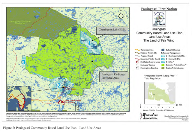
B.3. Zoning
The Pauingassi-Ontario planning area is designated as two zones (See Figure 2):
- Pauingassi Dedicated Protected Area: This zone supports protection of lands and waters, continued traditional use and existing and new tourism opportunities. The type of protected area and regulatory mechanism is to be determined jointly by Pauingassi and Ontario in a separate dialogue; and
- Enhanced Management Area: This zone supports both protection and potential economic development opportunities associated with areas of provincially significant mineral potential. This EMA is assigned to the cultural heritage category.
Several waterways flowing through the planning area are noted to be important for traditional use and natural heritage conservation. Significant cultural and ecological values are associated with these waterways and they have been identified as historical travel routes. These waterways will have continued traditional use and require a high level of protection of values. They may also offer distinct opportunities for activities such as tourism, guiding, cultural interpretation, research studies, etc., providing economic benefits.
Additional zoning at a resource management planning level (e.g., protected area planning) will be considered to emphasize the importance of waterways and promote complementary activities, and to protect special cultural sites identified by the community (These sites are not made public).
Description of zones and direction
Zone: Pauingassi dedicated protected area
Size: 108,493 hectares
Description:
This landscape includes numerous lakes such as the Namiwan, Rheaume and Palsen, each of which has associated ecological and cultural features. The area is traversed by a network of summer and winter traditional travel routes which are evidence of its rich cultural heritage. First Nation people conduct various traditional activities on this land for livelihood and cultural purposes.
No roads exist in the area. There are three remote tourism base lodges and outpost camps as well as four registered commercial boat caches. Current land use management in the area includes three bear management areas, and a commercial fishing licence. The area is within Wildlife Management Unit #2. The area is capable of supporting additional tourism and recreation opportunities focused on appreciation of boreal ecological and cultural landscapes (e.g. eco-tourism, provision of guided activities such as canoeing hiking and interpretation of features and values).
This area is notable for having several clear water lakes with healthy lake trout populations, a species that is relatively uncommon in the surrounding area. Indigenous knowledge and wildlife surveys confirm the presence of woodland caribou and wolverine, and woodland caribou winter habitat.
Land use intent:
The intent is to regulate the DPA as a protected area, although the specific designation and category are yet to be determined. The purpose of the designation is to promote protection objectives while supporting continuation of traditional uses and existing tourism, and to contribute to social and economic objectives by advancing potential for new tourism opportunities and inclusion in the Pimachiowin-Aki World Heritage Site nomination.
The land use intent recognizes the importance of waterways as historical travel routes having significant cultural and ecological values and promotes activities that are complementary to protection of those values, including protection of special cultural sites identified by the community.
This designation will protect specific values or features on the landscape that represent Ontario’s geological, aquatic and terrestrial diversity, protect landscapes of natural or cultural significance and contribute to the conservation of biodiversity and maintenance of ecological integrity.
Management Direction:
Pending confirmation of the category of protected area, this direction is interim; Additional specific direction will be provided accompanying the decision on a protected area category and by future resource management planning.
Aboriginal traditional activities protected by Aboriginal and treaty rights which include (but are not limited to) hunting, trapping, fishing, and gathering are ongoing and will continue to be managed by Pauingassi First Nation. The following interim direction is provided for other land use activities in the Pauingassi Dedicated Protected Area:
Other permitted uses:
- Travel by motorized boat, snow machine, all-terrain vehicle (ATV) or airplane.
- Recreational sport fishing, hunting, research/education,
- Commercial fur harvesting, commercial fishing, commercial non-timber forest products (NTFP), commercial tourism, wild rice harvesting.
Excluded uses:
- Commercial forestry, mineral exploration, mining, commercial hydroelectric development (transmission or generation), commercial wind power development, new energy transmission and communication corridors.
- Road building, aggregate extraction, peat extraction.
- Bait fishing
Zone: Cherrington Lake Enhanced Management Area – Natural Heritage category
Size: 30,270 hectares
Description:
The EMA includes Cherrington Lake and extends west to the Manitoba border. First Nation people conduct various traditional and customary activities for livelihood and cultural purposes. The area boundary is designed around a greenstone belt with low to moderate mineral potential. There are no roads currently in the EMA. There are three outpost operators and four registered boat caches. Management boundaries relevant to the area include one bear management area, traplines, and a wildlife management unit.
Land use intent:
The intent is to promote protection objectives including sustaining the high quality fish and wildlife resources, traditional uses and existing tourism. Land use in this EMA may contribute to social and economic objectives by encouraging the pursuit of potential new tourism opportunities and by permitting mineral sector opportunities while sustaining the cultural landscape.
The Enhanced Management Area has also been identified to protect remote recreation and tourism interests and complement protection interests of the Dedicated Protected Area. Forestry will not be pursued as an opportunity in this area.
Management direction:
Aboriginal traditional activities protected by Aboriginal and treaty rights which include (but are not limited to) hunting, trapping, fishing, and gathering are ongoing and will continue to be managed by Pauingassi First Nation.
Other permitted uses:
- Mineral exploration and development
- Travel by motorized boat, snow machine, all-terrain vehicle (ATV), airplane.
- Recreational sport fishing, hunting, research/education.
- Commercial fur harvesting, commercial fishing, commercial tourism, wild rice harvesting, commercial NTFP.
- Aggregate extraction is permitted for site specific needs associated with the mineral sector; extraction for export of aggregate beyond the area is not permitted natural features are to be maintained.
- Roads are generally discouraged, but are permitted within the area if required to access mineral sector opportunities. The number of roads will be minimized. Roads would be developed in a manner that seeks to retain the integrity of the cultural and natural features and high quality remote tourism operations.
- Energy transmission and communication corridors are discouraged, but are permitted if required to support advanced mineral sector opportunities.
Excluded uses:
- Commercial forestry
- Peat extraction
- Bait fishing
B.4. Strategic direction:
The following direction will guide how the land use plan is to be implemented and how activities and developments will take place in a manner consistent with the stated goals and objectives. Specifics of land and resource use management are considered and confirmed through subsequent processes (e.g. resource management planning, environmental assessment). Strategic level direction is not intended to address specific management actions.
B.4.1 Direction for all land uses:
Pauingassi First Nation and the OMNR acknowledge that the preparation and implementation of this lands use plan will respect Aboriginal and treaty rights and rights under the Canadian Constitution, in particular Section 35; will be consistent with/will not alter existing provincial legislation and will be within the bounds of provincial policy.
All land uses will take place in a manner that:
- respects Pauingassi’s traditional use and stewardship of these traditional lands as a recognized foundation that will help inform the use and management of these lands and waters and provide continuity in the connection of First Nation people to the land for past, present and future generations. Strategic direction is to:
- bring forward traditional use and resource stewardship traditions, teachings and practices as part of a conservation approach (providing for care of the land);
- make decisions based upon traditional values, teachings/methods and knowledge, along with science, providing the best knowledge currently available in terms of forests, land, water, wildlife, plants and fish management;
- recognizes the importance of:
- encouraging training for youth in the future lands and resources management opportunities,
- building respectful, sharing relationships; and
- relying upon the knowledge and teachings of elders;
- relies upon an ongoing knowledge base, evaluation and recommendations for best management practices and protection measures to:
- support the ongoing health of the boreal forest;
- promote healthy watersheds;
- provide a continuous supply of fish & wildlife habitat, including for species at risk;
and - protect cultural & natural heritage values from negative impacts;
- access to special sites will be solely for community members unless otherwise designated. Pauingassi will identify those special sites that require additional protection measures;
- recognizes the importance of identifying and supporting achievement of economic development opportunities that could benefit the members of Pauingassi First Nation and Ontario;
- respects existing stakeholder interests and encourage positive relationships;
- supports definition and promotion of opportunities to mitigate climate change;
- applies current/emerging science and expertise to recommend measures that can protect ecological processes and retain the value of stored carbon in the boreal forest and ground;
- recognizes the importance of ongoing learning from experience (i.e., adaptive management) for land use activities and resource management planning;
- respects the land and resources and retains the integrity of the area;
- considers local to broad scale aspects of all land uses (e.g., ecological, geographic) and cumulative effects (temporal &/or spatial); and
- in the face of uncertainty or risk, uses the precautionary principle to make decisions about land use and management. The ‘precautionary principle’ involves acting to avoid serious or potential harm to people or the environment where there is scientific uncertainty about likelihood, magnitude, or source of that harm.
B.4.2 Direction for specific land use activities:
Traditional uses
- Fishing and hunting for food by community members is a priority.
- Community members building hunting and trapping cabins in the planning area are encouraged to identify their location to OMNR, for the purpose of fire suppression and protection of natural and cultural values.
- Community members will continue to use and maintain snow machine trails for winter access to trap lines and cabins.
- Pauingassi First Nation will address direction for traditional and customary uses in all future protected areas and resource management planning.
Commercial trapping
- Commercial trapping can continue in the planning area.
- Pauingassi’s direction for commercial trapping is based on the customary stewardship approach of the community and consistent with Ontario policies, including;
- All trap lines must be held by community members. If a trap line is not held by a community member it will be held in common by the community.
- Pauingassi will pursue creation of a “Trapping Council” in the community, proposing that the trapping council will;
- develop management policies consistent with Ontario regulations.
- pursue the ability to sell commercial trapping licenses.
- review any proposed changes in head trapper for each Ontario trap line.
Renewable energy development
- Pauingassi will identify locations to be considered for community members’ energy use/needs.
- Acceptable proposals for energy development would include small scale (i.e. non commercial, stand alone) micro hydro, wind, solar and geothermal (e.g., supporting lodges, outpost camps, trap cabins, etc.).
- Additional direction may be provided within a management plan for the protected and enhanced management areas
Mineral sector activities
- Develop and encourage use of a suite of Best Management Practices for mineral sector activities.
- Encourage the consultation of Pauingassi First Nation members in mineral sector activities (e.g. training, exploration, partnerships, business opportunities).
- Support early consultation and engagement requirements with Pauingassi First Nation; Pauingassi will seek to define an impact-benefit agreement with proponent.
- Address mining withdrawals from culturally sensitive sites as identified by community leadership.
- Minimize surface disturbances near water bodies and streams to ensure healthy/intake watersheds are maintained
footnote 1 . - Emphasize the importance of rehabilitating mineral development areas in a timely manner.
- Ongoing monitoring scheduling and water quality sampling will be incorporated into resource management planning.
Recreation
- Opportunities for Pauingassi First Nation to benefit economically from recreational activities will be pursued in the planning and management of the protected and enhanced management area (e.g., partnerships, business opportunities, and participation in management).
- Sport fishing and hunting will continue as a land use activity in the planning area following Ontario regulations.
- Private motor boat use is permitted. Existing boat caches are permitted except where protected area objectives or values are threatened. New activities will be subject to review.
- Access by snowmobiles, all-terrain vehicles and aircraft is permitted, except where dedicated protected area values or objectives may be compromised.
- Long term direction will be provided through Pauingassi-Ontario dialogue, classification and management planning.
Commercial fishing
- Pauingassi can bring forward proposals for commercial fishing opportunities in the planning area.
- Proposals for new licenses will be subject to a review by OMNR, together with Pauingassi.
Forestry
- Commercial forestry is not permitted in the Pauingassi-Ontario planning area.
- Cutting trees is permitted for personal use, e.g., for camps, building cabins or fire wood; Additional direction may be provided within a management plan for the protected area.
- No trees will be harvested in specified sensitive natural and cultural areas.
Commercial Non-timber Forest Products (NTFP)
- Additional direction to support potential for commercial NTFP opportunities will be addressed in a protected area management plan.
Tourism
- Potential new opportunities will be considered jointly by Ontario and Pauingassi (in light of the objectives) to determine whether, and how the opportunity will be pursued. The jointly- developed management plan for the protection area may also provide direction on available opportunities.
- Recognize interest in planning new community-based tourism initiatives and promote First Nation owned operations for new tourism ventures.
- Encourage building new partnerships with existing tourism operations.
- Respect for existing tourism operations, encourage positive relationships and partnerships with Pauingassi.
- New and existing tourism establishments must operate in accordance with environmental standards and regulations, and in some cases incorporate enhanced Best Management Practices (BMP’s) for water quality protection (i.e. septic systems).
New commercial activities in the planning area (e.g. sale of water) are subject to review for consistency with the dedicated protected area objectives and values. Additional direction may be provided in a management plan.
Best management practices will be used to manage human waste, garbage, effluent in the protected and enhanced management areas.
For tourism and recreation, fuel caches for existing licensed operations will be maintained per the current license. In the future best practices will be reviewed and new conditions may be recommended for the operations.
B.4.3 Additional direction for the management of lands and resources
Fisheries and wildlife management
- Pauingassi will participate in dialogue with Ontario to bring forward the community’s interests in management direction for sustainable fisheries resources and wildlife management.
Species at risk (Endangered Species Act, 2007)
- Pauingassi and OMNR will work together to explore opportunities for joint research projects, gathering information and youth education projects.
- Pauingassi traditional knowledge and direction from OMNR will be applied in subsequent decision making processes to further protect habitat and the needs of species at risk.
Fire management / suppresion
- All fire fighting fuel caches will be mapped. If fuel caches are in a sensitive area they will be removed.
- Pauingassi and OMNR will develop a fire management plan for the protected area management plan. This plan can include identification of high value sites identified by PFN (e.g. cultural sites, cabins) and include identification of appropriate locations of fire fuel caches to avoid.
Protected area management
- Pauingassi will participate jointly with Ontario to prepare management plans and implement direction.
- Pauingassi will continue to participate in dialogue for opportunities associated with the Pimachiowin-Aki World Heritage Site nomination and protected areas.
Part C: Implementation
The Pauingassi Community Based Land Use Plan, 2011 is endorsed by Pauingassi First Nation under a Band Council Resolution and by a Minister’s Order under the Far North Act , 2010.
Implementation of this plan will follow direction provided, with success measured by the achievement of Pauingassi and OMNR shared objectives set out in section A.2. Implementation will take place respecting that dialogue will continue regarding Dedicated Protected Areas and the overlapping land use interests of Deer Lake First Nation. A joint plan implementation approach will be described by Pauingassi First Nation and OMNR.
The Far North Act 2010 (Section 14 (1)) specifies that once a community based land use plan is approved, decisions respecting the allocation, disposition or use of public land and natural resources in the area must be consistent with the land use designations and permitted uses specified in the plan and the permitted uses prescribed for the purpose of the plan. In itself, the plan does not alter existing authority, nor does it confer new authorities. Pauingassi First Nation’s relationship to the land and traditional uses will continue and are reaffirmed through the plan.
Subsequent to this plan, land and resource allocations, resource management planning (e.g. protected area management planning) and resource management activities will be subject to the OMNR obligations under the Environmental Assessment Act and other relevant legislation such as the Provincial Parks and Conservation Reserves Act and the Public Lands Act.
C.1 Implementation actions
Providing land use direction for the Pauingassi-Ontario planning area is an important step. To implement the plan, the following actions will be taken:
- For the Dedicated Protected Area, Pauingassi First Nation and the OMNR will:
- determine final protected area regulatory mechanism and designation category(ies) in subsequent agreements (the types of protected area designations available would include existing under the Provincial Parks and Conservation Reserves Act and may include new types associated with the Far North Planning Initiative);
- provide public consultation opportunities during the process when the protected areas are regulated and /or new policy direction is provided;
- prepare a management plan; and
- through dialogue, Pauingassi and the OMNR will pursue an arrangement for the collaborative management of the protected area in Ontario.
- Propose a joint approach for future decision making, with respect for Aboriginal and treaty rights, considering:
- development of future resource management plans;
- all information sources including Pauingassi indigenous knowledge and science; and
- new uses as they can contribute to land use plan objectives, including desire for an improved community economy, training, and jobs for Pauingassi First Nation people.
- Pauingassi First Nation and Ontario will continue to work with their partners to prepare supporting documentation for the development of the Pimachiowin Aki UNESCO World Heritage Site nomination.
- Pauingassi First Nation will pursue a dialogue with Ontario to address the creation of a Community Trapping Council (Section B.4.2).
- Working together with the MNDMF, Pauingassi and OMNR will develop a suite of Best Management Practices for mineral sector activities in the Enhanced Management Area.
- Pauingassi First Nation will continue to work together with adjacent communities through First Nation to First Nation discussions on shared interests and opportunities, including neighbours Deer Lake, Poplar Hill, St. Theresa, Little Grand Rapids and Pikangikum First Nation.
- In plan implementation, Deer Lake First Nation, Pauingassi First Nation and Ontario will continue a dialogue on interests with and considerations for Cherrington Lake. When Deer Lake proceeds with a CBLUP process, new information and clarification of interests may lead to a review of the zoning and/or strategic direction provided for Cherrington Lake within the Pauingassi Plan (Cherrington Lake EMA).
- Pauingassi will determine interest in, and may initiate a place naming (Geonaming) project with OMNR.
C.2 Monitoring plan achievement
Monitoring achievements is important to assess progress and the effectiveness of the plan, and to support formal plan review and renewal. Pauingassi and OMNR will describe a joint approach to monitor ongoing achievement of the plan objectives.
C.3 Review and renewal
The plan is a living document. It will be kept current and active by continuing to update information and providing documentation of implementation successes and issues. A consensus-based protocol between Pauingassi First Nation and the OMNR will be provided to consider requests for amendments and provide opportunities for public input, if required.
Periodically, the effectiveness of direction and decisions contained in the plan will need to be reevaluated. A formal review will take place once every fifteen years, beginning in 2026, following a joint process similar to that taken in preparation of the plan.
Thank you for your interest in our Pauingassi Community Based Land Use Plan. We encourage you to contact the community and the OMNR with your views, questions or comments on this plan.
Contact people:
Land Use Planning Coordinator
Pauingassi First Nation
Far North Planner
Red Lake District, Ministry of Natural Resources
Footnotes
- footnote[1] Back to paragraph 1 Ministry of Northern Development, Mines and Forestry will consider withdrawing aboriginal culturally significant sites in the Far North of Ontario from prospecting, staking, sale or lease.