Deer Lake Far North community based land use planning terms of reference
The terms of reference for Deer Lake First Nation community based land use planning.
![]()
Prepared by:
Deer Lake First Nation and the Ministry of Natural Resources
Contact Info:
Roland Pemmican, Land Use Planning Coordinator
Deer Lake First Nation
Michelle Schlag, Resource Liaison Specialist
Red Lake District Ministry of Natural Resources
On this day February 27, 2013 Deer Lake First Nation and the Ministry of Natural Resources are pleased to sign the Terms of Reference for the Deer Lake First Nation Community Based Land Use Plan. Approvals have been provided by:
- Deer Lake First Nation Band Council Resolution;
- and Ontario, by the Minister of Natural Resources administering the Far North Act, 2010
As we begin this planning process, Deer Lake First Nation and the Ministry of Natural Resources affirm our commitment to work together with mutual respect and in good faith.
On behalf of Deer Lake First Nation
Chief Roy Dale Meekis
Deer Lake First Nation
On behalf of Ontario
Honourable David Orazetti
Minister of Natural Resources
Deer Lake, ON, P0V 1N0
P.O. Box 39
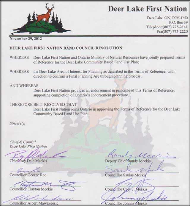
November 29, 2012
Deer Lake First Nation Band Council Resolution
Whereas Deer Lake First Nation and Ontario Ministry of Natural Resources have jointly prepared Terms of Reference for the Deer Lake Community Based Land Use Plan;
Whereas the Deer Lake Area of Interest for Planning as described in the Terms of Reference, with direction to confirm a Final Planning Are through planning process;
And whereas Deer Lake First Nation provides an endorsement in principle of this Terms of Reference, supporting completion of Ontario’s endorsement procedure.
Therefore it be resolved that Deer Lake First Nation joins Ontario in approving the Terms of Reference for the Deer Lake Community Based Land Use Plan.
Sincerely,
Chief & Council
Deer Lake First Nation
Chief Roy Dale Meekis
Signed by,
Councillor George Rae
Signed by
Councillor Clayton Meekis
Signed by
Councillor Albert Mawakeesic
Signed by
Deputy Chief Randy Meekis
Signed by
Councillor Saulas Meekis
Signed by
Councillor Cory J.Meekis
Signed by
Councillor Johnny Meekis
1.0 Background information
1.1 Context for planning
Deer Lake First Nation (“Deer Lake”, “DLFN”) is a community of 1211 people in northwestern Ontario. The Deer Lake community feels there is an urgent need to move forward with planning.
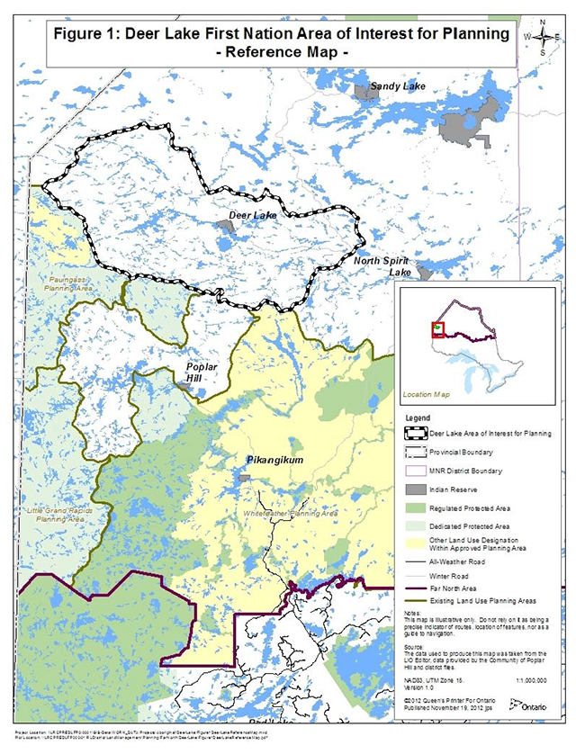
Adjacent communities to the south and west of Deer Lake are Pikangikum, Poplar Hill and Pauingassi First Nations. Pikangikum and Pauingassi have completed land use plans in 2006 and 2011 respectively, and have mapped planning areas. Poplar Hill First Nation is in the initial stages of planning. Also located adjacent to Deer Lake is Sandy Lake and St Theresa Point (Manitoba) First Nations to the north and North Spirit First Nation to the east. See Figure 1.
The Keewaytinook Okimakinak tribal council represents Deer Lake, one of six communities within their council. Keewaytinook Okimakinak has hosted, in partnership with the Ontario Ministry of Natural Resources (MNR), four land use planning workshops in which Deer Lake has actively participated. Deer Lake has received funding supporting their land use planning coordinator position from the Ministry of Aboriginal Affairs.
MNR has also provided funding through Transfer Payment Agreements to assist in the setting up of the Deer Lake planning unit, training and to initiate documentation of Aboriginal Traditional Knowledge.
Deer Lake has been involved in the Pikangikum Whitefeather Forest management planning process. The community has also participated in the development of the Pauingassi First Nation Land Use Plan.
Deer Lake recognizes the benefits of developing a community based land use plan. The interests of the community are rooted in the protection of their traditional lands and preserving their relationship to the land that they have enjoyed over time. The community would like to address their protection interests along with their resource development opportunities through this planning process.
The Far North Act, 2010 sets out the following objectives for land use planning in the Far North:
- A significant role for First Nations in the planning.
- The protection of areas of cultural value in the Far North and the protection of ecological systems in the Far North by including at least 225,000 square kilometres of the Far North in an interconnected network of protected areas designated in community based land use plans.
- The maintenance of biological diversity, ecological processes and ecological functions, including the storage and sequestration of carbon in the Far North.
- Enabling sustainable economic development that benefits the First Nations.
These objectives have been taken into account in the preparation of the Terms of Reference, and will be taken into account in the preparation of the land use plan.
Figure 1: Reference map
2.0 Purpose
The Terms of Reference is to identify a planning area and direct the preparation of a Community Based Land Use Plan for that area. The Terms describe a shared understanding between Deer Lake and MNR on the context and scope for planning, expected outcomes and steps in a consultative process. The Terms identify requirements to complete the mandatory components of a plan as specified under the Far North Act, 2010.
3.0 Expected outcomes of the plan
The land use plan is expected to define land use areas and desired and compatible activities, and provide strategic direction for the manner in which activities should take place. This plan will inform decisions on proposals for land and resource use in the future. Once a community based land use plan is approved, decisions must be consistent with the land use designations and permitted uses specified in the plan.
The planning process will provide for the following outcomes, to:
- Record and share traditional knowledge when appropriate (determined by DLFN) to communicate the relationship of Deer Lake with the land;
- Assemble and share all available information supporting planning;
- Describe goals and objectives for the plan;
- Determine desired and compatible (i.e. preferred) land uses and opportunities;
- Identify geographic areas (i.e. land use areas) and the development, land uses and activities that are permitted or not permitted within each area, consistent with goals and objectives;
- Identify the designation for each land use area (i.e. protected areas, general use areas, enhanced management areas);
- Identify at least one protected area;
- Describe how the plan has addressed the significant cultural and ecological features, land uses and land use designations for areas adjacent to the planning area;
- Provide guiding direction for the manner in which desired activities would take place, including direction to support continued use of traditional lands and enhance traditional uses by DLFN;
- Provide opportunities for input by community, adjacent communities and all interested people and organizations;
- Describe implementation of the plan, including requirements for review of the plan and how DLFN and MNR will work together in subsequent land use and natural resource management decisions; and
- Provide a Plan Review Period of 15 years, as specified by DLFN, not withstanding special requests by Deer Lake to review at earlier date.
As planning proceeds, planning will incorporate Ontario’s broader policy direction and emerging guidance (i.e. Far North Land Use Strategy).
4.0 Scope
4.1 Planning area
Location and description:
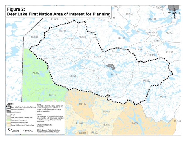
Deer Lake has identified an area of interest for planning for the purpose of preparing a Community Based Land Use Plan. The Deer Lake area of interest for planning (DLAIP) is 420,415 hectares in size, situated within the geography described by the Far North Land Use Planning Initiative and within the geography for which First Nations relationship to the province of Ontario is established through Treaty #5. The DLAIP is defined as those traplines that are currently held by, and or trapped by the members of Deer Lake (traplines 127, 123, 125, 126, 124, 120, and 122). These traplines fall within the community’s broader traditional territory in which the community continues to practise their traditional activities. See Figure 2.
The Deer Lake community and the DLAIP are situated:
- South of Sandy Lake First Nation;
- Southeast of St Theresa Point First Nations (Manitoba),
- East of Pauingassi First Nation (Manitoba) and the Ontario planning area for the 2011 Pauingassi Community Based Land Use Plan (planning area defined by currently‐held traplines);
- North of Little Grand Rapids First Nation (Manitoba) and the Ontario planning area for the 2011 Little Grand Rapids Community Based Land Use Plan (planning area defined by currently‐held traplines);
- North of Pikangikum First Nation land use planning area for the Whitefeather Forest Community‐based Land Use Strategy, Keeping the Land, 2006; and
- North of Poplar Hill First Nation and west of North Spirit First Nation.
Understanding of the planning area:
The Deer Lake area of interest for planning (DLAIP) area is defined with the following understandings:
- Deer Lake and MNR recognize that additional dialogue with adjacent First Nations is required to reach agreement on the planning area (and that changes may be required as a result of that dialogue).
- Deer Lake and MNR agree to proceed with the early stages of planning (i.e. information gathering, community promotion and public consultation, description of objectives and opportunities) while in dialogue with adjacent communities. Additional information and understanding of shared interests in the planning area can support and enhance the dialogue.
- The DLAIP will be confirmed in the Draft Plan stage, documented in the Draft Plan and recommended for designation as a planning area under the Far North Act.
Figure 2: Deer Lake First Nation areas of interest for planning - reference map
Adjacent First Nation communities:
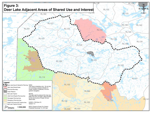
First Nations adjacent to the DLAIP are: Sandy Lake, Pauingassi, St Theresa Point, North Spirit Lake, Pikangikum and Poplar Hill. Deer Lake First Nation is providing a preliminary map of areas of shared use and interest with Pikangikum, Sandy Lake, and Pauingassi adjacent to the DLAIP (see Figure 3). A description of existing and anticipated DLAIP planning dialogue and shared use and interest areas considerations with each community follows:
North Spirit Lake:
At this time, there are no issues identified by North Spirit with the Deer Lake Planning Area. Dialogue is ongoing to share information and consider land use planning interests. This dialogue will continue throughout the planning process.
Pauingassi:
The existing Pauingassi designated planning area, established by approved plans under the Far North Act are respected. Deer Lake has a shared area of use and interest with Pauingassi in the Cherrington Lake area that has been considered through dialogue and planning in the Pauingassi land use plan. Regular dialogue will take place between the communities to consider historical and customary use in shared areas for preparation of the Deer Lake land use plan and implementation of the Pauingassi land use plans.
Pikangikum:
Deer Lake FN shares interests in the McInnes Lake area with the neighbouring community of Pikangikum. This area is located at the northern portion of the Whitefeather Forest and represents a headwater lake of Deer Lake and is accessed by the Deer Lake people through the McInnes River which flows north into Deer Lake. Deer Lake is currently engaged in the Whitefeather Forest management planning process to ensure their values are considered in this plan.
Sandy Lake:
Deer Lake has confirmed an area of shared use and interest with Sandy Lake in the Favourable Lake area. At this time, there are no issues identified by Sandy Lake with the Deer Lake Planning Area. Dialogue is ongoing to share information and consider land use planning interests. This dialogue will continue throughout the planning process.
Figure 3: Deer Lake adjacent areas of shared use and interest map
St Theresa Point:
At this time, there are no issues identified by St. Theresa with the Deer Lake Planning Area. Dialogue is ongoing to share information and consider land use planning interests. This dialogue will continue throughout the planning process.
Poplar Hill:
At this time, there are no issues identified by Poplar Hill with the Deer Lake Planning Area. Dialogue is ongoing to share information and consider land use planning interests. This dialogue will continue throughout the planning process.
4.2 Planning subjects
In the preparation of planning direction for the Planning Area, the planning team may consider:
Historical indigenous use:
- Direction will be provided to harmonize historical livelihood pursuits of First Nations in the Planning Area with strategic direction and new uses.
- The relationship of Deer Lake FN with respect to the planning area will be described, with objectives identified to address the First Nation interests.
Protected areas:
- Identify recommendations for protected areas within the Planning Area.
- Recommend direction for protected areas that is consistent with First Nation stewardship and livelihood opportunities.
- Recommend protected areas that can contribute to achievement of landscape‐scale representation, Ontario’s Far North goals, and to sustain species a risk in an ecologically‐sound approach.
- Recommend protected areas, and land use zones that complement the intended Boreal World Heritage Site goals.
Forestry:
- Describe the landbase in terms of the capability for forestry, and identify the type of forestry opportunity that would be of interest to pursue (i.e. small scale operation – saw logs supporting community projects).
- Provide compatible land use zones to support desired opportunities.
- Provide guiding direction for the use of forest resources.
Non‐timber forest products (NTFP):
- Describe the landbase in terms of non‐timber forest products.
- Identify existing use and provide direction to support future NTFP opportunities.
Mineral exploration and mining:
- Provide information on Provincially‐significant Mineral Potential (PSMP) for the Planning Area.
- Achieve consensus on balance between areas of exploration and areas excluded from exploration.
- Provide compatible zoning to support or restrict opportunities.
Recreation:
- Identify capabilities for, and recommendations for recreation opportunities in the Planning Area.
- Provide complementary land use zoning to support desired opportunities.
Tourism:
- Identify existing and potential opportunities in tourism.
- Provide complementary land use zoning to support opportunities.
- Provide recommendations for preferred tourism activities and direction to enhance tourism through definition of management objectives.
Infrastructure:
- Identify interests and needs in infrastructure development such as roads or corridors.
- Provide land use zoning that will be compatible with identified interests/needs to support future assessment of infrastructure location/corridors.
- Provide strategic direction regarding compatibility of infrastructure with proposed land use zones.
Waterways:
- Strategic direction will be provided for protection and conservation of waterways.
- Describe opportunities within waterways for recreation, tourism purposes.
- Identify strategic direction, and appropriate land use zoning for waterways.
Climate change mitigation:
- As land use planning proceeds, the planning team will discuss climate change and opportunities where the plan may contribute to the mitigation of climate change.
5.0 Planning process
5.1 First Nation community and stakeholder involvement in planning
All interested people and organizations will be invited to engage in a dialogue on land use planning through a variety of mechanisms that include; meetings, environmental registry postings, open houses and mail outs.
The community will use the local Television station and posters to invite community members to the open houses in Deer Lake. The planning team will also provide links on local Facebook pages and websites, Environmental Bill of Rights Environmental Registry and other information notices.
Initial efforts to invite consultation with other local First Nation communities, resource users (tourist operators, anglers, hunters, forest industry, and mineral exploration/mining industry), government, municipalities and the general public having an interest in the planning area will occur by giving direct written notice of the intent to prepare this strategic land use direction. Persons not included in the initial mailing list but who wish to become involved in the planning process will at their request have their names added to the mail out list.
Mail outs will be sent out and meetings held to provide resource values information at each phase of the planning process in order to solicit input into the land use plan.
A general Public Notice will be placed in the following local newspapers; Northern Sun and Wawatay.
The Deer Lake Land Use Plan will be a policy posting on the Environmental Registry with notice at Terms of Reference, updated notice at Draft Plan and decision notice at Final Plan.
Notice of open houses will be mailed to all names on the mail out list at least fifteen (15) days prior to the open house. Documents that are produced through this planning exercise will be made available for public review and comment. A summary of comments will be available to the public. Open houses will be held in both DLFN community and in the Town of Red Lake, providing both local and regional access to the consultation opportunity.
Comments and submissions will be collected, addressing the requirements of the Far North Act, the Environmental Bill of Rights, the Freedom of Information and Protection of Privacy Act. Ontario respects and will address its requirements for consultation with First Nations.
5.2 Approval mechanism
The planning team will make decisions by consensus and where they fail to reach consensus, they will seek further guidance within their respective governance structure i.e. DLFN First Nation Council, MNR senior managers.
The Far North Act identifies requirements and authority for approvals, including for:
- Terms of Reference
- Planning Area
- Final Land Use Plan
Joint approvals for each of the above are required by:
- Deer Lake First Nation Chief and Council
- Minister of Natural Resources
Approval of the final plan will be by Minister’s Order under the Far North Act, 2010 and by First Nation Band Council Resolution. Prior to approval of the final plan, and with joint endorsement, the planning area will be designated under the Far North Act, 2010 via Minister’s Order. A written record of all decisions will be maintained and agreed to for decisions pertaining to the land use plan.
Upon endorsement of a final land use plan, the partners will implement the direction in good faith.
5.3 Interim measures
Ontario’s Far North Act provides for orderly development in the Far North. Under the Far North Act, community based land use plans must be completed before most major development begins, including commercial timber harvest or opening a new mine. The Act does allow certain types of development to proceed in advance of a plan, provided certain criteria are met. A development may also be allowed to proceed if it is determined to be predominantly for community use or if it contributes directly to meeting community needs of the First Nations and takes into account the objectives of the Act.
For proposals that may come forward during the planning process MNR and DLFN expect that joint planning team input would be invited to the consideration of development proposals and that decisions would be consistent with the provisions of the Far North Act.
Upon plan completion all decisions regarding allocations, dispositions, or use must be consistent with the land use designations and permitted land uses specified in the plan and the permitted activities prescribed for the purpose of the plan. (Section 14(1) Far North Act, 2010.
5.4 Phases and timeframe
In addition to the current preparatory phase, the formal consultative process consists of three main phases, with associated timeframes as follows:
Preparation phase ‐ current
- Finalize Land Use Planning Terms of Reference (two community meetings);
- Collection of information (i.e. FN values); and
- Seek Funding Support.
Phase 1 fall/winter 2012/2013
- Share Draft Terms of Reference with community (Fall 2012);
- Community and MNR endorse Terms of Reference Dec./Jan. 2012/13;
- First Open Houses (January/February 2013);
- Compile background information;
- Invite engagement and consultation through notices, mail outs etc.;
- Provide consultation opportunities through meetings and a first open house, in addition to the Environmental Bill of Rights registry posting and mail out;
- Identify objectives, interests, and opportunities, issues of community discussion, and preliminary discussion of zoning and land use activities.
Phase 2 winter/summer 2013
- Prepare preliminary draft plan including mapping for zoning and written proposals (June 2013);
- Share preliminary draft with provincial advisory group, including Far North Branch and MNDM;
- Share preliminary draft within community;
- Based on input from the community and provincial advisors, complete the Draft Plan, including confirmed planning area;
- Provide a second public consultation opportunity, including the opportunity to provide written comments on the Draft Plan. This opportunity will include sector meetings, open house, public notices and faxes, and update to Environmental Registry with the Draft Plan (September 2013); and
- Recommend designation of confirmed planning area.
Phase 3 fall 2013
- Prepare preliminary Final Plan including discussion of how comments from phase 3 (Draft Plan) were addressed;
- Review of preliminary final plan in community;
- Review of the preliminary final version by MNR;
- Complete Final Plan document;
- Seek endorsement through approval processes (DLFN and MNR) reflecting a consensus on the land use plan (December 2013); and
- Complete decision notice for Environmental Registry posting.
5.5 Planning structure
The relationship of people and organizations to the planning process is illustrated in Figure 4. DLFN will identify representatives to act in an advisory capacity for the planning area. Representatives will attend planning team meetings and support the preparation of information and consultation needs as required.
Planning team structure

- Deer Lake Chief & Council
MNR Far North Senior Manager- Planning Team
- Community Planning Coordinator
Community Planning Assistants
Deputy Chief
Councillor
Far North Planner
District Planning Assistant - Community Advisory Group
- Chief and Councillors
Elders
KO Tribal Councillor
- Chief and Councillors
- Provincial Advisory Group
- Red Lake District Manager
MNDM planning Geologist
Far North Manager
Red Lake Information Management Supervisor
Natural Heritage Specialist
- Red Lake District Manager
- Technical Support Group
- MNR GIS Support
Consultant Support
- MNR GIS Support
- Community Planning Coordinator
- Planning Team
The planning team will be comprised of both MNR and DLFN representatives.
Members of this team representing DLFN are:
- Deer Lake Land Use Coordinator (Roland Pemmican)
- Planning Assistants:
- ATK planning assistant
- ATK planning assistant
- GIS planning assistant
- Deer Lake councillor (Clayton Meekis)
- Deer Lake Deputy Chief (Randy Meekis)
Members of this team representing Ontario MNR are:
- Far North Planner
- District planning assistant
- Far North Senior Planner, NW Region
Planning team members will be required to attend all meetings or notify absence in advance of meetings.
The Community Advisory Group will be a membership comprised of one councillor with Lands portfolio and Elders and trappers. The planning team will be responsible for providing updates to the community advisory group and present the final land use strategy to the group prior to final approval.
The Provincial Advisory Group is comprised of regional planning specialists and will be called upon to present provincial policy and planning direction and participate in workshops as required. The planning team will be responsible for updating the provincial advisory group throughout the planning process. The provincial advisory group membership will be comprised of:
- Red Lake District Manager
- Far North Manager, NW Region
- Northwest regional natural heritage specialist
- MNDM regional geologist
- Red Lake Planning and Information Management Supervisor
5.6 Dispute resolution
Issues not resolved through discussions with the planning team pertaining to the Planning Area can be addressed directly to the MNR Red Lake District Manager and Deer Lake First Nation Chief and Council. Parties bringing forward a dispute or issue shall provide it in writing to the MNR Red Lake District Manager, and Deer Lake Chief and Council, along with any proposed resolution. The District Manager will confer with the Chief, as appropriate in an effort to reach agreement on a resolution. The respective parties may also seek advice from the provincial and community advisory groups in reviewing the issue. The District Manager and Chief (or designate) will confer, as appropriate, in an effort to reach a resolution and will communicate any resolution to the Planning Team within 30 days.
6.0 Information management
Information is an important element of the Community Based Land Use Planning process.
The planning process will require consideration of all available information to help support and inform joint planning discussions while respecting and protecting Indigenous Knowledge. A joint protocol between the community and MNR will be established that will outline what information will be brought forward by each party and how it will be used in the Community Base Land Use Planning process.
All community information used to support the planning process will remain with the community unless the community deems it shareable with the Province of Ontario.
MNR will provide and support the planning team with their best available information and data, to be used for the purpose of Community Based Land Use Planning.
The primary source of information on current mining claims is MNDM’s CLAIMaps Internet site. This site maps all mining claims within Ontario. Use of information from this site is an essential part of the land use planning process.
Ontario Parks will provide information for landform/vegetation types, natural heritage features and areas and advise on the application of ecological criteria to identify, select, design, and assess candidate protected areas (representation, condition, diversity, ecological functions and special features).
In addition, the joint planning team will identify appropriate information management strategies for the information used to support the development of the CBUP. The joint planning team will oversee communications and delegate as required, including developing and ensuring public notices are submitted as required, compiling a mailing list, initiating mailings of planning phase information, notices of meetings, and any other information deemed appropriate.
The joint planning team will ensure compliance with requirements for information under the authority of the Freedom of Information and Protection of Privacy Act, the Far North Act and the Archives and Recordkeeping Act. Notices required for consultation purposes under the Environmental Bill of Rights will be the primary responsibility of the MNR. The subjects and results of consultation will be considered by the planning team and incorporated into the planning process.
All formal input and comments received during the planning process will be documented and available as an official planning record. Copies of all formal input and comments received during the process will be provided to the joint planning team.
7.0 Glossary
- Terms of reference
- Agreement between First Nations and Ontario; sets objectives and process that will guide the development of a community based land use plan.
- Community Based Land Use Planning
- It is a process to determine the most appropriate use of the land. It identifies which lands to dedicate for protection and which are to be used for potential sustainable economic development.
A community based land use plan becomes the foundation that guides future decisions on the land base.
- Land Use Designations
- Zones representing dedicated protected areas (DPA), enhanced management areas (EMA), and general use areas (GUA)
- DPA: Areas where industrial development is not permitted i.e. commercial forestry, mineral exploration.
- EMA: Areas where industrial activities may be permitted, but may have conditions in place to sustain areas of high conservation interest.
- GUA: Areas in which all activities are permitted
- Background Information
- Gathering and documenting Aboriginal traditional knowledge, science, land and resources information.
- Traditional Territory
- A traditional territory is a broad landscape area in which community members have used and continue to use to carry out their traditional and lively hood pursuits.
- Non‐timber Forest Products (NTFPs)
- NTFPs are botanical products harvested or originating from forest‐based species. They exclude primary timber products, industrial boards and composites, and paper products.
- Provincially Significant Mineral Potential (PSMP)
- PSMP Mineral Resource Assessment (MRA) methodology is a cost‐effective tool for assessing the mineral‐related values of areas of interest. It allows qualified workers to assess an area of interest using readily available geoscientific information to quantify the likelihood of finding an economic mineral resource that adds value to Ontario’s economy, or may do so within the foreseeable future.
- Environmental Bill of Rights Registry
- The Environmental Registry contains public notices about environmental matters proposed by government ministries covered by the Environmental Bill of Rights.