2016 community based land use plan terms of reference: Mishi Sakahikaniing McDowell Lake First Nation
Terms of reference for McDowell Lake First Nation community based land use planning.

On this page
- 1.0 Introduction
- 2.0 Background
- 3.0 Planning Relationship
- 4.0 Purpose
- 5.0 Scope of Planning
- 6.0 Planning Subjects
- 7.0 Planning Process
- 8.0 Planning Structure
- 9.0 Approval Mechanism
- 10.0 First Nation Community and Stakeholder Involvement in Planning
- 11.0 Interim Measures
- 12.0 Dispute Resolution
- 13.0 Information Management
1.0 Introduction
McDowell Lake First Nation (MLFN) is leading a Community Based Land Use Planning process, working jointly with the Ministry of Natural Resources and Forestry (MNRF), to prepare a Community Based Land Use Plan. The purpose of the Terms of Reference is to describe this land use planning process. The Terms of Reference describes a shared understanding between MLFN and MNRF on the context and scope for planning, expected outcomes and steps in the process, which includes both the mandatory components of a plan as specified under the Far North Act, 2010 and the vision and wellbeing of McDowell Lake First Nation people.
McDowell Lake First Nation Reasons for Planning include:
- Protection of the homeland of McDowell Lake First Nation people for future generations
- Identifying and supporting Community development and economic opportunities
- Building awareness and capacity for the people of MLFN to decide about and engage in activities on the land
MLFN and MNRF hold a mutual interest in a planning process that respects all parties and adjacent communities. Both parties recognize that our interests for planning may be different but through a respected planning process we hope to address these differences for the benefit of MLFN, MNRF and neighboring communities.
This Terms of Reference, as prepared by the MLFN-MNRF Planning Team, outlines McDowell Lake First Nation’s desired approach to planning, which is supported by MNRF and Ontario through consensus, mutual respect and good faith.
2.0 Background
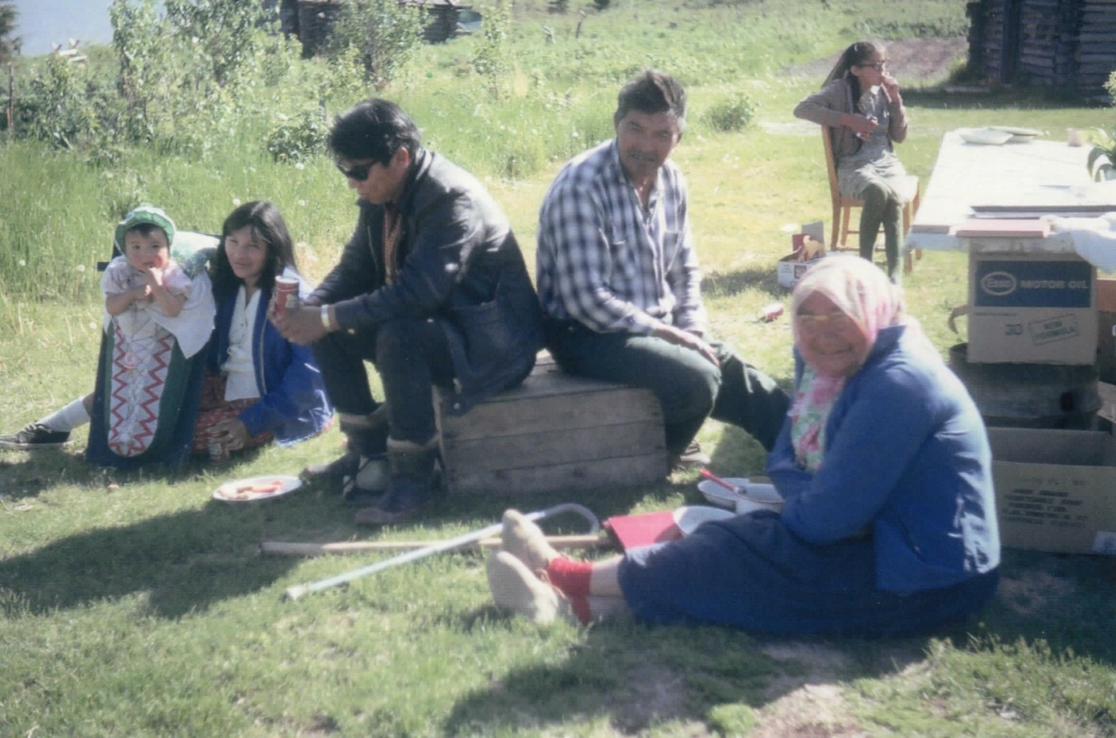
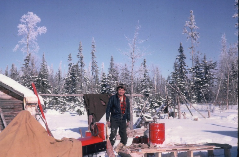
In the mid-1940s, the Community of McDowell Lake was founded by a trapper, Johnny Kenequanash, who came over from Windigo Lake. During that time, the McDowell Lake was used as a waterway by the trappers who lived in the surrounding area. McDowell Lake was rich in fur bearing animals, fish and game animals such as moose, caribou, bear and waterfowl. Known in the Oji-Cree language as Mishi Sakahikaniing (Big Lake), McDowell Lake is located 155 kilometres northeast of Red Lake.
When Johnny settled in McDowell Lake there was a white trapper here known as Mattson. After Johnny settled in McDowell Lake he invited his brother in law, Magnus James, to join him. Along with Magnus, Thomas Thompson, brother-in-law of Magnus, came and joined the group. Also, Aglaba James, son of Magnus, moved down. These people had resided around the North Spirit Lake and Sandy Lake areas before moving to McDowell Lake.
The founding Oji-Cree families of MLFN built a village and Community at McDowell Lake and made the area their homeland. At the time, the main economic base was trapping, hunting and fishing. In the late 1950s, commercial fishing also became part of the local economy. McDowell Lake people also worked in seasonal occupations, such as forest firefighting and tree planting. The 1940s to the late 1980s was a vibrant time for the Community of McDowell Lake. Many young families thrived based on traditional livelihoods, practices and economic pursuits. The village site included a small school, church, an icehouse and fish house, several residences and even some small farming activity and gardens.
In the mid-1980s, many families had to leave McDowell Lake to access education for their children. From the late 1980s to early 2000s, McDowell Lake people took up residence in Red Lake, Dryden, Thunder Bay, other surrounding communities and urban settings. It was a quiet time at the village site, with Community members returning seasonally at various points in the year to keep up their connection to their homeland.
Through the efforts of leadership and Community members, McDowell Lake was established as a First Nation in 1985. Since the early 2000s, families have been returning to the Community on a more frequent basis. As of 2015, there are now 60 MLFN band members.
McDowell Lake First Nation is a small Community with a strong connection to their homeland. MLFN has a Community development objective to establish facilities and services at McDowell Lake to enable their membership to once again inhabit the Community year round. The McDowell Lake First Nation Community Based Land Use Plan is intended to support this objective.
3.0 Planning relationship
Points of contact between MNRF and McDowell Lake must recognize and respect the importance of good relationships. The relationship between McDowell Lake people and the MNRF has generally been positive since the founding of the Community. Continued mutual respect is a key principle of maintaining this good relationship. A good planning relationship is built on continuous dialogue, open communication, reciprocity and respecting each other’s sources of knowledge.
The Community has been engaged with MNRF in the early stages of planning, values mapping and initial discussions on the scope and intent of land use planning since 2011.
The First Nation and MNRF have jointly developed this Terms of Reference for a Community Based Land Use Plan to lay out a framework for a future formal planning process.
4.0 Purpose
The purpose of the Terms of Reference is to identify an Area of Interest for planning and direct the preparation of a Community Based Land Use Plan for that area. The Terms of Reference describes a shared understanding between MLFN and MNRF on the context and scope for planning, expected outcomes and steps in the process. The Terms of Reference identifies requirements to complete the mandatory components of a plan as specified under the Far North Act, 2010.
Vision, principles and objectives for planning
The vision of McDowell Lake Community is one that our ancestors and our elders hold dear; to see their children grow up in a land they can call their own and to see their grandchildren live in harmony in a self-sustaining Community, where our descendants can be proud and carry forward these values to our future generations.
Principles for Planning:
- Planning shall proceed in a manner that respects First Nation traditional activities across all of Planning Area
- Planning shall be carried out in a way that respects and is consistent with the exercise of Aboriginal and Treaty Rights
- McDowell Lake shall continue to carry on and promote its responsibility to respect the land, water and animals
- McDowell Lake and Ontario recognize that the land and environment is continuously changing. The needs and interests of the Community also change over time. Planning is intended to be an ongoing, long-term process that promotes continuous learning and adapts to change
The Community Based Land Use Planning process takes into account the Far North Act 2010 Objectives for land use planning in the Far North:
- A significant role for First Nations in the planning.
- The protection of areas of cultural value in the Far North and the protection of ecological systems in the Far North by including at least 225,000 square kilometres of the Far North in an interconnected network of protected areas designated in Community based land use plans.
- The maintenance of biological diversity, ecological processes and ecological functions, including the storage and sequestration of carbon in the Far North.
- Enabling sustainable economic development that benefits the First Nations.
The Vision, Principles and Objectives shall be taken into account throughout the planning process.
Expected outcomes
The plan shall document the heritage, history and the story of the McDowell Lake Community. The plan shall support McDowell Lake as a self-sustaining Community by bringing forward the Community’s interests, according to the vision of the late Elders.
Through planning, McDowell Lake shall confirm a final planning area for development of a Community Based Land Use Plan.
The plan shall affirm a good working relationship with the government of Ontario.
The plan shall set out land use areas within the planning area to describe land uses and activities within those areas.
Continued involvement and dialogue with Community members is integral to the development of the McDowell Lake Community Based Land Use Plan. The plan shall express the vision and goals of all members, from Youth to Elders.
5.0 Scope of planning
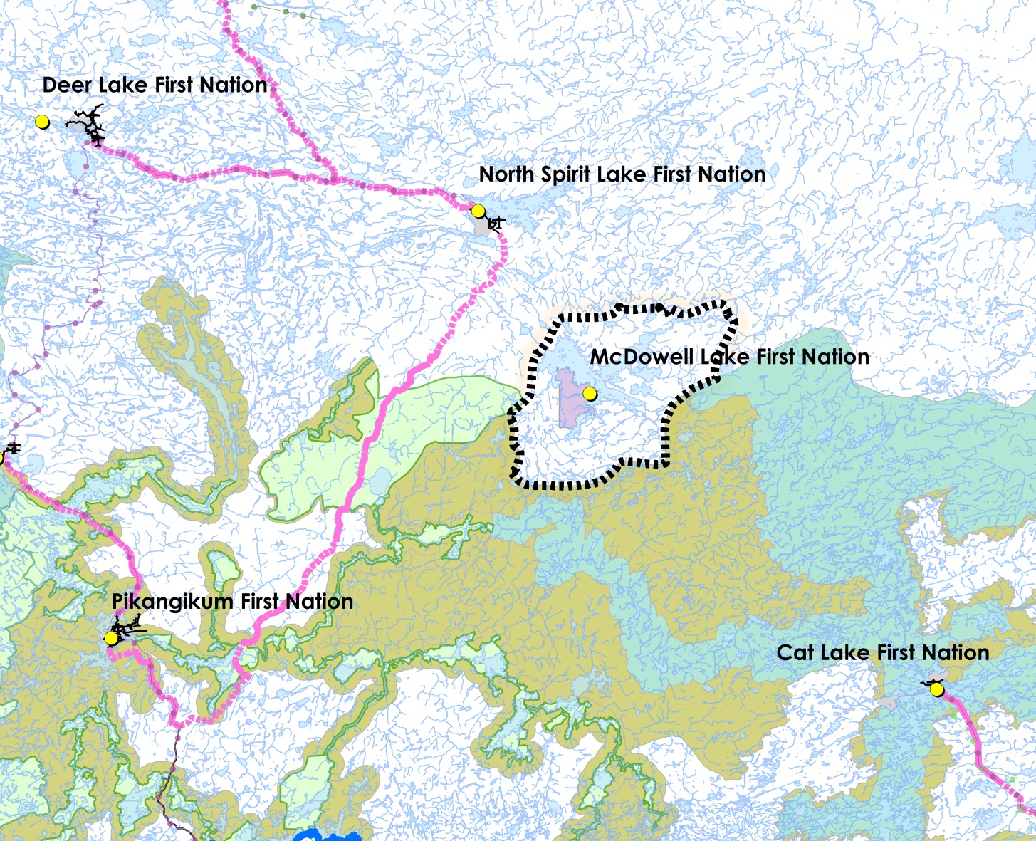
The Community has an Area of Interest for Planning based on the McDowell Lake member-held trap line RL147. This area is part of a broader traditional use area to which McDowell Lake people are connected. The Area of Interest for Planning is approximately 89,450 hectares in size.
The following communities are located around the Area of Interest for Planning:
- Pikangikum
- North Spirit Lake
- North Caribou Lake
- Cat Lake
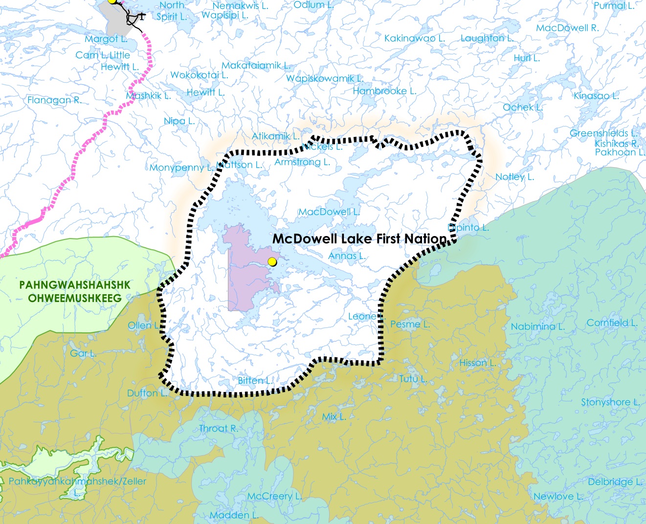
The following Planning Areas are located adjacent to the Area of Interest for Planning:
- Cat Lake and Slate Falls Community Based Land Use Plan
- Whitefeather Forest Plan
It is understood that the Area of Interest for Planning shall be discussed and confirmed with these neighboring communities. Dialogue with adjacent communities may continue throughout the planning process in order to build an understanding of shared areas and to support the designation of the planning area at the draft plan stage.
6.0 Planning subjects
The planning subject list below was created by MLFN membership through meetings and dialogue. They feel these subjects are the most important considerations at the present time for the well-being of our community and to achieve our vision. The planning team understands that this list may change as more information becomes available.
The McDowell Lake Community Based Land Use Planning process shall address the following planning subjects:
Mineral resources, aggregates and geoscience
- Review information on surficial and bedrock geology within the planning area;
- Identify existing mining claims
- Explore ways to build Community capacity relating to geosciences and the mineral sector;
- Build an understanding of the current mineral development processes;
- Identify areas with the potential to host mineral and aggregate deposits;
- Identify and support future mineral and aggregate development opportunities in the planning area
- Explore ways for McDowell Lake First Nation people to lead and benefit from mineral sector activities in the planning area; and
- Obtain other available geoscience information that is relevant to the community’s interests (e.g., landforms, groundwater, and natural hazards)
Protected areas
- Water is a primary interest for protection. While water protection across the Area of Interest is emphasized, source water is an especially high priority for protection and conservation.
- The planning process shall explore appropriate protected area opportunities within the planning area
- The planning process shall build an understanding of what protection and protected areas means to McDowell Lake First Nation People.
- Planning shall build an understanding of Community cultural values and locations that should be protected
- The land use plan will identify at least one protected area and consider contributions to an interconnected network of protected areas
- Protection of species at risk habitat will be a consideration in protected area design
Fire management
MLFN and MNRF will engage each other to:
- Understand MNRF’s Provincial Fire Management Strategy and ways it can support fire protection in the Area of Interest for Planning
- Build an understanding of community values and the impact of fire on local community resources.
- Identify Community forest-based values in order to determine appropriate fire protection approaches
- Identify Community cultural values and locations for fire protection
Renewable energy
Through the planning process, MLFN shall engage MNRF:
- To explore renewable energy potential and opportunities within the Area of Interest, such as wind, solar, waterpower, biomass, etc.
- To bring forward Community interests in renewable energy development
Forestry and non-timber forest products (NTFP)
It is understood that McDowell Lake First Nation shall lead the development of new commercial forestry and NTFP activities within the Area of Interest. MLFN intends to work with MNRF:
- To identify forest resources that are available around McDowell Lake
- To define opportunities that exist for Community based forestry activities in the Area of Interest for Planning
- To explore Community interests and opportunities in commercial harvest of plants, mushrooms or other non-timber forest products
Commercial resource harvest
- McDowell Lake has an interest in maintaining and encouraging future Community leadership in commercial resource harvesting activities, such as commercial fishing and trapping.
- Planning and Implementation shall explore ways to continue a tradition of commercial trapping by current and future generations of McDowell Lake First Nation people.
- Planning shall support the best use of the fisheries on McDowell Lake and surrounding water bodies, and identify ways to ensure the health of the resource through recreational fishing, tourism and commercial fishing as appropriate.
Linear corridors
Planning shall consider McDowell Lake First Nation future needs, neighboring community and regional connections relating to:
- All season roads
- Improved winter road access
- Transmission lines
- Fibre optic communication
Tourism
- The planning process may identify new opportunities for commercial tourism establishments
- Planning can address how tourism activities should remain respectful of residents of McDowell Lake, and how guests of tourism establishments can be respected by those who live within the Community.
Climate change
- Climate change is recognized as a significant phenomenon that may be addressed through planning
- The traditional knowledge of McDowell Lake First Nation people may be shared on the subject of climate change
- McDowell Lake First Nation and MNRF may identify climate change research and monitoring, mitigation and adaptation approaches through the planning process
Far North Land Use Strategy
McDowell Lake First Nation and MNRF recognize the Far North Land Use Strategy and will carefully consider the direction and guidance for planning provided in this document.
7.0 Planning process
Engagement between MNRF and MLFN with respect to land use planning began in 2010-11. MLFN completed Aboriginal Traditional Knowledge collection and documentation over 2011-13. MLFN began drafting a Terms of Reference in spring 2015. MLFN and MNRF anticipate joint approval of the Terms of Reference in early 2016. After the Terms of Reference is approved, next steps are:
- Stage 1: Terms of reference
- Stage 2: Draft plan
- Stage 3: Final plan
8.0 Planning structure
Elders Advisory Group
- Laura James
- Ida James
- Mary Lawson
- Margaret Lawson
- Albert James
- Eli James
- Rebecca Cromarty
- Emily James
Elders Advisory Group
Members of the Elders Advisory Group are the guiding force of the community based land use planning process. Elders are avaliable to advise the Planning Team and the younger generation to ensure that their vision for planning becomes a reality for our community.
Youth Advisory Group
The youth of the community provide insight into a changing culture and offer the Planning Team their ideas as to how the land use plan can address their interests and goals for the future and further development of the McDowell Lake community.
- Dylan Cockroft
- Hilarry Lawson
- Dakota Pelly
- Kieran Beardy
- Kaylene Lawson
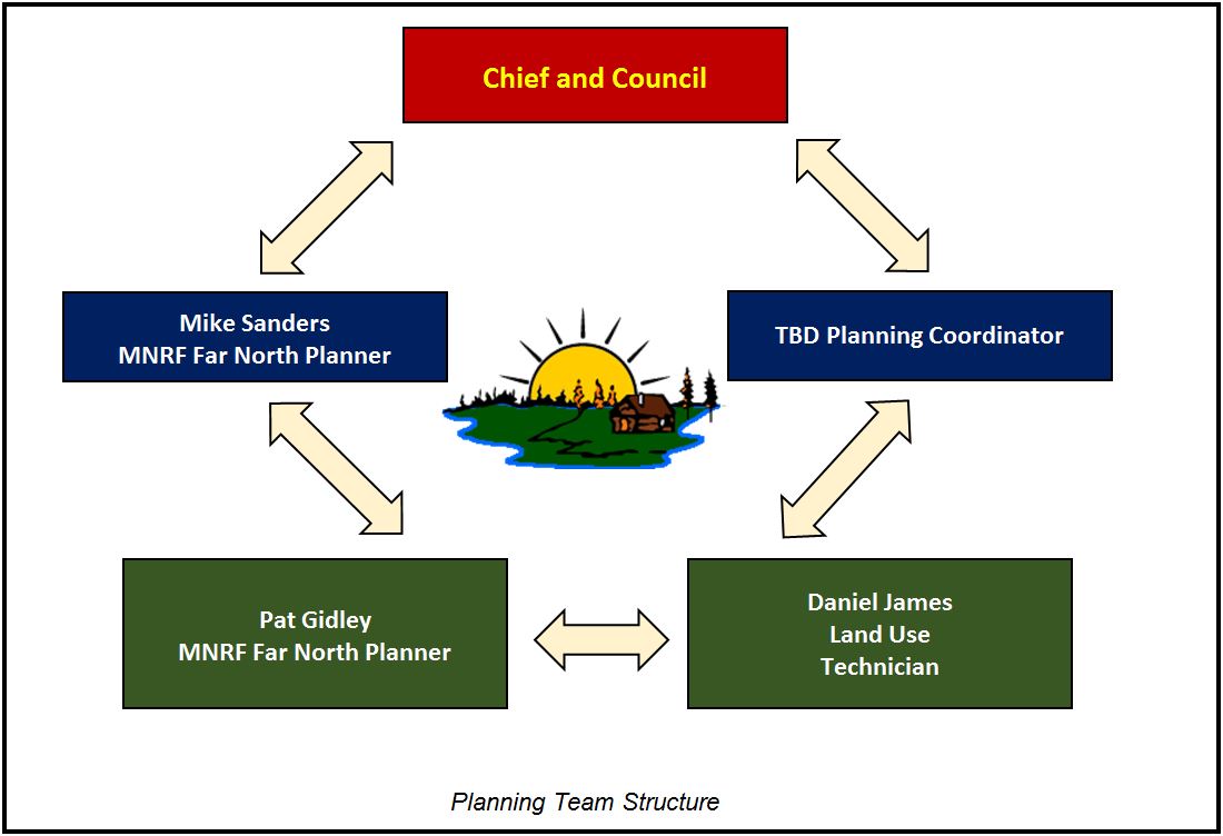
The planning team
The planning team takes a lead role in preparing the land use plan and assembling information and mapping to support planning. In addition, Planning team representatives support engagement and involvement of community members, advisors and interested parties in the planning process, while also:
- Making sure that all teams are working together effectively.
- Making sure that the plan is moving forward and on schedule.
- Ensure the the planning teams have the resources needed to complete their objectives.
- Keeping everyone up to date on current progress with bi-monthly reports
- Assigning task appropriate work to each of the teams
- Taking a lead role in preparing the Terms of Reference, the land use plan and preparing and reviewing ammendments to the plan once completed
Planning Team advisors
A number of individuals will be called upon to advise, support and provide information to assist in the preparation of the McDowell Lake First Nation Community Based Land Use Plan, such as:
- Keewaytinook Okimakanak – Donald Meekis, Armanda Cimon and Franz Seibel
- Governance Planner TBD
- Technical consultants
- MNRF Far North Planning Manager
- MNDM Planning Geologist
- Provincial Natural Heritage Specialist
- District Resource Operations Supervisor
- Others as Necessary
9.0 Approval mechanism
The planning team shall make decisions by consensus and where they fail to reach consensus, they shall seek further guidance within their respective governance structure i.e., McDowell Lake First Nation Chief and Council, Elders’ Advisory Group and Community Members and MNRF Senior Managers.
The Far North Act identifies requirements and authority for approvals, including for:
- Terms of Reference Planning Area
- Final Land Use Plan
Joint approvals for each of the above are required by:
- McDowell Lake First Nation Chief and Council
- Minister of Natural Resources and Forestry
Approval of the final plan shall be by First Nation Band Council Resolution and Minister’s Order under the Far North Act, 2010. Prior to approval of the final plan, and with joint endorsement, the planning area shall be designated by a First Nation Band Council Resolution and under the Far North Act, 2010 via Minister’s Order. A written record of all decisions shall be maintained and agreed to for decisions pertaining to the land use plan.
Upon endorsement of a final land use plan, the partners shall implement the direction in good faith.
10.0 First Nation community and stakeholder involvement in planning
All interested persons or organizations shall be invited to engage in a dialogue on land use planning through a variety of mechanisms that include; meetings, environmental registry postings, open houses and mail outs.
The Community shall use social media and direct notification to invite Community members to the open houses in Red Lake, Thunder Bay and McDowell Lake. The planning team shall also provide links on local Facebook pages and websites, Environmental Bill of Rights Environmental Registry and other information notices.
Initial efforts to invite consultation with other local First Nation communities, resource users (tourist operators, anglers, hunters, forest industry, and mineral exploration/mining industry), government, municipalities and the general public having an interest in the planning area shall occur by giving direct written notice of the intent to prepare this strategic land use direction. Persons not included in the initial mailing list but who wish to be kept aware of the planning process will at their request have their names added to the mail out list.
Mail outs will be sent out and meetings held to provide resource values information at each phase of the planning process in order to solicit input into the land use plan.
A general Public Notice will be placed in local newspapers;
The McDowell Lake Land Use Plan will be a policy posting on the Environmental Registry with notice at Terms of Reference, updated notice at Draft Plan and decision notice at Final Plan.
Notice of open houses will be mailed to all names on the mail out list at least fifteen (15) days prior to the open house. Documents that are produced through this planning exercise will be made available for public review and comment. A summary of comments will be available to the public. Open houses will be held, providing both local and regional access to the consultation opportunity.
Comments and submissions will be collected, addressing the requirements of the Far North Act, the Environmental Bill of Rights, the Freedom of Information and Protection of Privacy Act. Ontario respects and will address its requirements for consultation with First Nations.
The planning team will review all comments received through consultation opportunities and consider them in the development of the draft and final plans.
11.0 Interim measures
Community Based Land Use Plans must be completed before most major development begins, such as commercial timber harvest or opening a new mine. The Act does allow certain types of development to proceed in advance of a plan, provided certain criteria are met. A development may also be allowed to proceed if it is determined through consensus by MLFN and MNRF to be predominantly for Community use or if it contributes directly to meeting the needs of MLFN and takes into account the objectives of the Act.
For proposals that may come forward during the planning process MNRF and McDowell Lake expect that Joint Planning Team input would be invited to the consideration of development proposals and that decisions would be consistent with the provisions of the Far North Act.
Upon plan completion all decisions regarding allocations, dispositions, or use must be consistent with the land use designations and permitted land uses specified in the plan and the permitted activities prescribed for the purpose of the plan (Sect 14(1) Far North Act, 2010).
12.0 Dispute resolution
The Planning Team shall work together to prepare the land use plan through a consensus-based approach. Where the team fails to reach consensus, issues not resolved through the Planning Team pertaining to the planning process can be addressed directly to McDowell Lake First Nation Chief and Council and senior MNRF staff. The Planning Team may also seek advice from McDowell Lake First Nation’s Elders’ Advisory Group, Community members and provincial advisory groups in reviewing the issue.
Outside parties bringing forward a dispute shall address their concerns to the Planning Team. If a party feels that the Planning Team has not adequately addressed the dispute, they can provide Chief and Council and MNRF senior staff a written explanation of the issue along with any proposed resolution.
McDowell Lake and MNRF (or designate) shall confer, as appropriate, in an effort to reach a resolution and shall communicate any resolution to the Planning Team and parties within 30 days.
13.0 Information management
Information is an important element of the Community Based Land Use Planning process.
The planning process shall require consideration of all available information to help support and inform joint planning discussions while respecting and protecting Indigenous Knowledge. The Community and MNRF will outline what information will be brought forward by each party and how it will be used in the Community Base Land Use Planning process.
All Community information used to support the planning process shall remain with the Community unless the Community deems it shareable with the Province of Ontario.
MNRF will provide and support the planning team with all relevant provincial information and data, to be used for the purpose of Community Based Land Use Planning.
The primary source of information on current mining claims is MNDM’s CLAIMaps Internet site. This site maps all mining claims within Ontario. Use of information from this site is an essential part of the land use planning process.
MNRF will provide information and offer advice on landform/vegetation types, natural heritage features and areas to support ecological considerations for protected areas (e.g., representation, diversity, ecological functions and special features).
In addition, the Planning Team will identify appropriate information management strategies for the information used to support the development of the CBLUP. The Planning Team will oversee communications and delegate as required, including developing and ensuring public notices are submitted as required, compiling a mailing list, initiating mailings of planning phase information, notices of meetings, and any other information deemed appropriate.
The Planning Team shall ensure compliance with requirements for information under the authority of the Freedom of Information and Protection of Privacy Act, the Far North Act and the Archives and Recordkeeping Act. Notices required for consultation purposes under the Environmental Bill of Rights will be the primary responsibility of the MNRF. The subjects and results of consultation shall be considered by the planning team and incorporated into the planning process.
All formal input and comments received during the planning process will be documented and available as an official planning record. Copies of all formal input and comments received during the process will be provided to the Planning Team.
Prepared by
McDowell Lake First Nation and the Ministry of Natural Resources and Forestry
Contact information
Daniel James
Land Use Technician
McDowell Lake First Nation
(807) 735-1381 ext. 1198
Mike Sanders
Far North Planner
Ministry of Natural Resources and Forestry
(807) 727-1343
![]()
McDowell Lake First Nation P.O. Box 321 Red Lake, ON P0V 2M0
Telephone 807-735-1381 Ext. 1308 Fax 807-727-9494
First Nation Band Council Resolution
Whereas McDowell Lake First Nation and Ontario Ministry of Natural Resources and Forestry have jointly prepared Terms of Reference for the McDowell Lake First Nation Community Based Land Use Plan.
Whereas the Area of Interest for Planning as described in the Terms of Reference, with direction to confirm a Final McDowell Lake First Nation Planning Area, through the planning process.
Whereas McDowell Lake First Nation provides endorsement in principle of this Terms of Reference.
Therefore, be it resolved that Ontario Ministry of Natural Resources and Forestry joins McDowell Lake First Nation in approving the Terms of Reference for the McDowell Lake First Nation Community Based Land Use Plan.

Chief Vontane Keno

Councillor Lois James

Councillor Sheryl Lawson
McDowell Lake First Nation Community Based Land Use Plan Terms of Reference
On this day, July 21st, 2016, McDowell Lake First Nation and the Ministry of Natural Resources and Forestry are pleased to sign the document, McDowell Lake First Nation Community Based Land Use Plan Terms of Reference. Approvals have been provided by:
- McDowell Lake First Nation Band Council Resolution; and
- Ontario, by the Minister of Natural Resources and Forestry administering the Far North Act, 2010.
As we begin this planning process, McDowell Lake First Nation and the Ministry of Natural Resources and Forestry affirm our commitment to work together with mutual respect and in good faith.
On behalf of McDowell Lake First Nation
Chief Ellen Vontane Keno
McDowell Lake First Nation
On behalf of Ontario
Honourable Kathryn McGarry
Minister of Natural Resources and Forestry