Little Grand Rapids Far North Community Based Land Use Planning Terms of Reference
The terms of reference for Little Grand Rapids Far North community based land use planning.
April 24, 2009
Prepared by:
Little Grand Rapids First Nation, in partnership with the Ontario Ministry of Natural Resources
Contact info:
Augustine Keeper, Land Use Planning Coordinator, Little Grand Rapids First Nation.
Lee Gerrish, Far North Planner, Red Lake District Ministry of Natural Resources
Note: This Terms of Reference dated April 24th includes a correction made by the planning team on August 21, 2009 to replace the planning area map with a corrected version and to correct the size of the planning area accordingly. The Terms also includes updated language on the Far North Planning Initiative as of September 2009.
Foreward
Little Grand Rapids First Nation (LGRFN) is one of 6 proponents associated with the Boreal Forest World Heritage Site (WHS) nomination. This site, called Pimachiown Aki was placed on the WHS nomination list in 2004. The next step is to prepare for the submission. Having land use designations in place for the nomination area will contribute to a strong submission, providing clarity for objectives, goals and anticipated land uses.
Preparing land use direction in partnership with the associated provinces agencies (Ontario and Manitoba) will lead to formal implementation of land use designations and further illustrate the collaborative nature of the WHS proposal.
Thus, the WHS proposal is a strong catalyst for LGRFN and Ontario to move forward on the provision of strategic land use direction for the planning area identified by traplines held by members of the LGRFN within the First Nation’s self-described traditional territory within Ontario.
Ontario’s Far North Planning Initiative was launched in July 2008, with an announcement by the Premier of Ontario to protect more than 225,000 km2, or more than half of the Northern Boreal Region. The planning framework is to include both broad scale and local community planning, addressing the goals of conservation of ecosystems and functions, Aboriginal community involvement and environmentally sustainable economic development. In addition to the commitment for identification of protected areas, the announcement identifies that new forestry and opening of new mines in the Far North would require community land use plans supported by Aboriginal communities.
The planning process will be guided by LGRFN and the emerging policies and processes established in a Far North Planning Framework. The Ontario policy for Community- based Land Use Planning (MNR, 2002) provides the policy umbrella to enter into a planning process, in partnership with LGRFN, to consider all land uses and prepare strategic direction. This approach will be harmonized with the emerging Far North Planning Framework.
LGRFN and the Ontario Ministry of Natural Resources (OMNR) have committed to work in good faith as planning partners, and that:
- This Terms of Reference will guide the community-based land use planning process for the portion of LGRFN’s traditional use area in Ontario.
- Land use planning in Ontario will contribute to LGRFN’s long-term goal of completing land use planning for the entire area that it describes as its traditional area; and
- To achieve the objectives of the Far North Initiative.
Note: In July 2008 the government announced the Far North Land Use Planning Initiative and on June 2, 2009, Bill 191, an Act with respect to Land Use Planning and Protection in the Far North was introduced in Ontario’s Legislature.
Vision
The people of Little Grand First Nation have been part of the land from time immemorial (as long as the oldest elder of our community remembers). We believe and assert that we are part of the land. Our vision for the land is very much a vision for (of) ourselves. We wish to (use) manage our traditional land (in a way) so that our people as (being) part of the land are sustained into the future. For that purpose we are engaged in the steps needed to arrive at a land use plan for our traditional land in both Manitoba and Ontario.
Context
The Little Grand Rapids First Nation is working in partnership with OMNR within the context of the First Nation’s decision-making structure and the OMNR’s Far North Planning Initiative. OMNR participation in planning and requirements for approvals will incorporate Far North responsibilities, as they are described. Ontario’s Far North Planning Initiative has three broad policy goals: conservation of Far north ecosystems and functions, Aboriginal community involvement and environmentally sustainable economic development, plus a commitment to a land use planning system that has both broad scale and community-based planning.
This community-based planning initiative will be guided by the OMNR policy “Community-based Land Use Planning (C-LUP), October 2002”. In the planning framework, OMNR has obligations to provide a fair, open and transparent process, including public consultation opportunities for adjacent First Nation communities, interest groups and the general public.
Existing land use direction in this area of northwestern Ontario includes:
- The Bloodvein Canadian Heritage River begins in Ontario and overlaps the Planning Area. There is an existing management plan for the heritage river.
- Woodland Caribou Provincial Park in Ontario overlaps with the Planning Area. The park has a management plan in place.
- Whitefeather Forest Land Use Strategy “Keeping the Land”, 2006, prepared and approved by Pikangikum First Nation and OMNR.
A further important context is the immediately adjacent province of Manitoba. Liaison with Manitoba will take place through correspondence and scheduled meetings throughout the process to share information and ensure that cross-provincial interests are understood.
Purpose
The Terms of Reference are set out to direct a land use planning process to prepare strategic direction that will guide and/or provide input into decisions on land and resource use. All existing processes and requirements for land and resource use in Ontario will continue to apply to this area. Essentially, the purpose of the Terms of Reference is to describe a shared understanding, between LGRFN and OMNR, on the context for and scope of planning, expected outcomes and steps in a consultative process.
The land use planning process has a purpose to achieve an approved Land Use Strategy for the planning area. Strategic direction will:
- Describe goals and objectives for the planning area;
- Determine preferred land uses;
- Identify geographic areas (i.e., zones/land use designations) where defined land use activities are consistent with goals and objectives (e.g., protected areas, general use areas, enhanced management areas); and
- Provide guiding direction for the manner in which desired activities would take place.
Preparing strategic land use direction is important to LGRFN to:
- Communicate the relationship of the people of LGRFN in all its aspects with the land is understood and sustained;
- Support the continued use of traditional lands and enhance traditional uses;
- Record, and share traditional knowledge;
- Benefit from opportunities from traditional lands;
- Harmonize objectives of LGRFN and OMNR in land use and natural resource management; and
- Determine protection zones and other land use designations that will support economic, environmental and social benefits for LGRFN, who have a historical traditional land use relationship with the planning area.
In addition, land use planning is important to Ontario to:
- Support wise, orderly decision-making for lands and resources in the planning area;
- Support achievement of provincial goals, including contributing to a Far North vision; and
- Provide land use direction that will support economic, environmental and social benefits for the people of Ontario.
For both partners, planning will foster reconciliation of interests, and clarify processes, policies and structures, including recommendations for input to decision-making approaches for the future and improved operational decision-making processes for addressing the interests of the partners.
Goals, Principles, Objectives
Statements of goals, principles and objectives will be confirmed in the early stages of the planning process as part of a dialogue on planning issues, opportunities and interests.
Goals
The goals of LGRFN to be achieved by the planning process are to:
- Sustain the natural world for present and future generations;
- Identify possible economic developments pursuant to the strategic land use direction which may include but are not limited to mining, tourism, low impact energy developments and other like developments;
- Contribute to management of the Planning Area, as land use may support an improved community economy, training, and jobs for LGRFN people; and
- Support and sustain LGRFN traditional knowledge, traditional land uses, and access to these lands, while balancing competing interests.
- Uphold and sustain our sovereign rights, both under Canada’s Constitution and our rights under Treaty 5, while planning for this traditional land use area and the future of our community.
- The policy goals for Ontario’s Far North Planning Initiative provide for a balance of social, economic and environmental priorities, including:
- The conservation of Far North ecosystems, including conserving special ecological systems and functions;
- Aboriginal community involvement in land use planning and protection of significant and vulnerable cultural features; and Environmentally sustainable economic development.
Principles
- The principles that will guide the planning process are:
- The people of the LGRFN:
- Have used the land within the Planning Area since time immemorial and
- Wish to benefit from economic opportunities therefrom;
- LGRFN and OMNR have a duty and interest to use this land in a way that protects and enhances it for future generations;
- LGRFN and OMNR will work cooperatively, and collaborate to develop jointly the land use strategy;
- The land use strategy and planning process will respect the connection between the people and land, and take into account traditional and local knowledge;
- Planning products based on community knowledge belong to the community;
- Each party will only speak for themselves; and
- All interested persons and organizations will have opportunity to engage in the planning dialogue, as it is an open, respectful and fair process.
Objectives
The objectives of this process are to:
- Prepare a land use strategy that is also a communication plan to share information about the relationship of the people of LGRFN in all its aspects with their land so that it is understood and sustained;
- Support continued use of traditional lands and enhance traditional uses;
- Record and share traditional knowledge;
- Identify opportunities that are desired and compatible with this area;
- Harmonize objectives of LGRFN and OMNR in land use and natural resource management;
- Determine protection zones and other land use designations;
- Incorporate Ontario’s broader policy direction and contribute to a Far North vision for sustainability of First Nation communities, ecosystems, species at risk and environmentally sustainable economic development; and
- Ensure opportunities for synergies with Far North planning objectives, ensuring that local planning decisions do not preclude broader scale options development.
First Nation community and stakeholder involvement in planning
All interested people and organizations will be invited to engage in a dialogue on land use planning through a variety of mechanisms that include; meetings, environmental registry postings, open houses and mail outs.
Initial efforts to invite consultation with other local First Nation communities, resource users (tourist operators, anglers, hunters, forest industry, and mineral exploration/mining industry), government, municipalities and the general public having an interest in the planning area will occur by giving direct written notice of the intent to prepare this strategic land use direction. Persons not included in the initial mailing list but who wish to become involved in the planning process will at their request have their names added to the mail out list.
Mail outs will be sent out and meetings held to provide resource values information at each phase of the planning process in order to solicit input into the land use plan.
A general Public Notice will be placed in the following local newspapers; Northern Sun, and Wawatay Newspaper.
The Terms of Reference, Draft and Final land use strategy will be posted as a policy proposal on the Ontario Environmental Registry under the Environmental Bill of Rights (EBR).
Notice of open houses will be mailed to all names on the mail out list at least fifteen (15) days prior to the open house. Documents that are produced through this planning exercise will be made available for public review and comment. A summary of comments will be available to the public. Open houses will be held in both Pauingassi and LGRFN and in the Town of Red Lake, providing both local and regional access to the consultation opportunity.
Comments and submissions will be collected, addressing the requirements of the Public Lands Act, the Environmental Bill of Rights, the Freedom of Information Act and the Protection of Privacy Act.
Ontario respects and will address its requirements for consultation with First Nations.
Planning area
Figure 1: Planning Area Reference Map
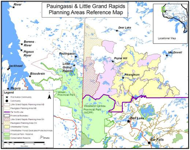
Enlarge Planning Area Reference Map
For the purpose of planning, the planning area is described as the portion of the traplines that fall within Ontario, excluding those portions that are within Woodland Caribou Provincial Park, that are held by members of the LGRFN, whose relationship to the province of Ontario is established through Treaty #5. This planning area is within the geography described with the Far North Planning Initiative. The LGRFN planning area lies to the northwest of the area defined as the Whitefeather Forest, north of Woodland Caribou Provincial Park and south of an area described by Pauingassi First Nation as part of their traditional land use area and west of an area described by Poplar Hill First Nation as part their traditional land use area.
The trapline system reflects the current use of the land and establishes respect for neighbouring First Nations’ land use. Moreover, the historical use of the land as defined by LGRFN includes customary land uses around traplines. It also includes travel routes traveling to traplines and activities carried out along the way such as camping, making fires, tea breaks, rests, berry picking, fishing, and hunting.
The process of affirming the boundary of the planning area will be through ongoing discussions with adjacent First Nations to identify overlapping interests and final planning area for LGRFN. The Ontario portion of the planning area is 189,796 ha.
Other planning and administrative boundaries which are directly relevant to this initiative are noted in Figure 1 include: Ontario’s Far North, Woodland Caribou Signature Site; the Manitoba border; and the surrounding communities of Red Lake, Pikangikum First Nation, Poplar Hill First Nation, and Deer Lake First Nation
The planning area to be considered is situated entirely in the Boreal Forest Region and is represented by ecoregions 3S and 4S. They are dominated by conifer stands, consisting primarily of jack pine and black spruce. Topography is gently rolling and drainage is generally good, though steep, rough areas of shallow soil as well as some fens and peat lands punctuate the terrain.
Planning subjects (scope of planning)
In the preparation of planning direction for the Planning Area, the planning team may consider:
Historical Indigenous use:
- Direction will be provided to harmonize historical livelihood pursuits of First Nations in the Planning Area with strategic direction and new uses.
- The relationship of LGRFN with respect to the planning area (i.e., the portion of the traditional use area in Ontario) will be described, with objectives identified to address the First Nation interests within Ontario.
Protected Areas:
- Identify recommendations for protected areas within the Planning Area.
- Recommend direction for protected areas that is consistent with First Nation stewardship and livelihood opportunities.
- Recommend protected areas contributions to achieve landscape-scale representation, Ontario’s Far North goals, and to sustain species-at-risk in an ecologically-sound approach.
- Recommend protected areas, and land use zones that contribute to the intended Boreal World Heritage Site goals for LGRFN.
Forestry:
- Describe the landbase in terms of the capability for forestry, and identify the type of sustainable forestry opportunity that would be of interest to pursue (e.g., forest resource licence, commercial licence).
- Provide compatible land use zones to support desired opportunities.
- Provide guiding direction for the use of forest resources.
- Non-timber forest products: NTFP
- Describe the landbase in terms of non-timber forest products.
- Identify existing use and provide direction to support future NTFP opportunities.
Mineral exploration and mining:
- Provide information on Provincially-significant Mineral Potential (PSMP) for the Planning Area.
- Achieve consensus on balance between areas of exploration and areas excluded from exploration.
- Provide compatible zoning to support or restrict opportunities.
Recreation:
- Identify capabilities for, and recommendations for recreation opportunities in the Planning Area.
- Provide complementary land use zoning to support desired opportunities.
Tourism:
- Identify existing and potential opportunities in tourism.
- Provide complementary land use zoning to support opportunities.
- Provide recommendations for preferred tourism activities and direction to enhance tourism through definition of management objectives.
Infrastructure:
- Identify interests and needs in infrastructure development such as roads or corridors.
- Provide land use zoning that will be compatible with identified interests/needs to support future assessment of infrastructure location/corridors.
- Provide strategic direction regarding compatibility of infrastructure with proposed land use zones.
Waterways:
- Strategic direction will be provided for protection and conservation of waterways.
- Describe opportunities within waterways for recreation, tourism purposes.
- Identify strategic direction, and appropriate land use zoning for waterways.
Climate Change Mitigation:
- As land use planning proceeds, the planning team acknowledges that climate change will be a subject of discussion, and opportunities to contribute to the mitigation of climate change through land use planning will be considered.
Planning process
Authority, Responsibilities and Decision Making
The planning process is designed with the following understandings for authority, responsibilities and decision-making:
Authority
The Far North Planning Framework will identify requirements and procedures for approval of the land use strategy.
The final land use strategy will be a guidance document. In itself, it does not alter existing authority, nor does it confer new authorities. OMNR and other provincial agencies have obligations set out in provincial policy and legislation.
LGRFN has a historical relationship to the land and customary stewardship responsibilities described by the community. All direction in this land use strategy is premised upon respect for Aboriginal and Treaty Rights.
Responsibilities
Each partner will implement these Terms of Reference in good faith, and in accordance with its laws, policies, customs, traditions and decision making processes and authorities.
LGRFN has the responsibility to lead planning dialogue and to support opportunities for community engagement in planning decisions. LGRFN also has the responsibility to facilitate the understanding of information on, and direction for traditional use, traditional knowledge and cross-cultural dialogue with agencies, stakeholders and the public.
Ontario has responsibilities to support completion of community-based land use planning in association with the Far North Planning Initiative. The planning process does not alter Ontario’s responsibilities for lands and resource management in the planning area. The Far North Planning Initiative may provide further guidance for definition of the planning relationship with Manitoba First Nations.
Decision Making
The planning team will make decisions by consensus and where they fail to reach consensus, they will seek further guidance within their respective governance structure i.e. LGRFN First Nation Council, OMNR senior managers.
Endorsement of the Land Use Strategy (the Community-Based Land Use Plan) will be required from Little Grand Rapids First Nation and the MNR.
The Far North Planning Framework will identify requirements and procedures for approval of the Community Land Use Plan. The Terms of Reference will be approved by the following signatories:
- Chief and Council
- Red Lake District Manager
- Far North Director
- Regional Director
A written record of all decisions will be maintained and agreed to for decisions pertaining to the land use strategy.
Upon endorsement of a final land use strategy, the partners will implement the direction in good faith.
Interim Measures
Ontario’s Far North Land Use Planning Initiative has provided direction that major development proposals, including new forestry or the opening of new mines, requires completion of a community based land use plan.
Development proposals will need to take into account the government’s commitments and land use planning policies. This includes meeting requirements for development activities in the Far North and specific considerations for development that contributes directly to meeting First Nation community needs or is predominantly for community use.
Phases and Timeframe
In addition to the current preparatory phase, the formal consultative process consists of four main phases, with associated timeframes as follows:
Preparation Phase -
- Finalize Land Use Planning Terms of Reference; Collection of Info (e.g. FN values, L/V,); Seek Funding Support.
Phase 1 Fall/Winter 2008/09
- Share and endorse Terms of reference
- Communicate relationship to Far North initiative
- Compile background information,
- Invite engagement and consultation through notices, mail outs, etc.
- Initiate Environmental Bill of Rights Environmental Registry policy posting
Phase 2 Fall 2009 (may be combined with Phase 1)
- Identify background information, interests and opportunities, issues of community discussion, preliminary discussion of zoning and land use activities
- Provide full dialogue in the community and with OMNR, including liaison with ongoing Far North Initiative.
- Provide consultation opportunities through meetings and a first open house, in addition to the Environmental Bill of Rights registry posting and mail out.
Phase 3 Spring 2010
- Prepare Draft land use plan including mapping for zoning and written proposals
- Provide community meetings, OMNR meetings and meeting with different sectors in Ontario,
- Provide a second open house, public notices and faxes, and update to Environmental Bill of Rights registry, with Draft Land Use Plan.
- Provide liaison with Far North to share proposed draft land use plan and review in light of ongoing Far North policy development.
Phase 4 Fall 2010
- Prepare Final land use plan including discussion of how comments from Phase 3 were addressed.
- Review of final version in community, review of the final version by OMNR,
- Provide endorsement through approval processes (First Nation and OMNR) reflecting a consensus on the land use plan.
Planning Structure
Figure 2 below describes the relationship of people and organizations to the planning process.
Figure 2: Planning teams
- OMNR Far North Director
- Provincial Advisory Group
- Red Lake District Manager
- Ontario Parks
- Natural Heritage Specialist
- MNDM – planning Geologist
- Far North Manager
- Red Lake Planning and
- Information Supervisor
- Provincial Advisory Group
- Chief and Council
- Community Advisory Group
- Councilor – planning portfolio
- LG Ontario Trappers
- Elders
- Planning Team
- Land Use Planning
- coordinator
- Youth Representative
- Far North Planner
- Far North Regional Planner
- Parks Planner
- Elder
- Two Trappers (TBA)
- Technical Support
- LG consultant
- Red Lake Information
- Management
- Technical Support
- Planning Team
- Community Advisory Group
LGRFN will identify representatives to act in an advisory capacity for the planning area. Representatives will attend planning team meetings and support the preparation of information and consultation needs as required.
The planning team will be comprised of both MNR and LGRFN representatives. Members of this team representing Ontario MNR are:
- Lee Gerrish – Far North Planner
- Doug Gilmore – Superintendent, Woodland Caribou Signature Site
- Jill Entwistle – Far North Senior Planner, NW Region
Members of this team representing LGRFN are:
- Augustine Keeper – Land Use Coordinator
- Ezra Bouchie - Elder
- Winston Keeper - councilor
- Collin Keeper – Trapper
- Scott Crow – Youth representative
Planning team members will be required to attend all meetings.
The Community Advisory Group will be a membership comprised of one councilor with Lands portfolio, and Little Grand Rapids trappers who have traplines in Ontario. The planning team will be responsible for providing updates to the community advisory group and present the final land use strategy to the group prior to final approval.
The Provincial Advisory Group is comprised of regional planning specialists and will be called upon to present provincial policy and planning direction and participate in workshops as required. The planning team will be responsible for updating the provincial advisory group throughout the planning process. The provincial advisory group membership will be comprised of:
- Roy Sidders – Far North Manager, NW Region
- Ron Leekam – Northwest regional natural heritage specialist
- Andreas Lichtblau – MNDM regional geologist
- Trevor Park – Red Lake District planning and information management supervisor
Dispute resolution
Issues not resolved through discussions with the planning team pertaining to the Planning Area can be addressed directly to the MNR Red Lake District Manager and Little Grand Rapids First Nation. Parties bringing forward a dispute or issue shall provide it in writing to the MNR Red Lake District Manager, and Little Grand Rapids First Nation, along with any proposed resolution. The District Manager will confer with the local planning co- coordinator or Chief, as appropriate in an effort to reach agreement on a resolution. The respective parties may also seek advice from the provincial and community advisory groups in reviewing the issue. A response may be expected within 30 days following the review of the dispute or issue.
Information management
Information management will be an important component of the land use planning process. This will include consideration for data sharing and use, through data sharing agreements, and include discussion of appropriate use and protection of Indigenous Knowledge.
The primary source of information on current mining claims is MNDM’s claimaps Internet site. This site maps all mining claims within Ontario. Use of information from this site is an essential part of the land use planning process.
Ontario Parks will provide information for landform/vegetation types, natural heritage features and areas and advise on the application of ecological criteria to identify, select, design, and assess candidate protected areas (representation, condition, diversity, ecological functions and special features).
The planning team will oversee communications and delegate as required, including developing and ensuring public notices are submitted as required, compiling a mailing list, initiating mailings of planning phase information, notices of meetings, and any other information deemed appropriate.
All formal input to and comments received during the process will be documented and a summary provided as a consultation record. Provincial requirements related to the collection of comments and information will be identified to the planning team. OMNR must ensure that its responsibilities are addressed, including those under the Freedom of Information and Protection of Privacy Act and the Public Lands Act.
Notices required for consultation purposes under the Environmental Bill of Rights will be the primary responsibility of OMNR. The subjects and results of consultation will be considered by the planning team and incorporated into the planning process.
Implementation
LGRFN and OMNR will implement these Terms of Reference for a land use strategy in good faith, sharing information. During the planning process, new information and/or emerging direction may require an amendment to the Terms of Reference. In this event, the planning team would prepare a recommended amendment and the amendment would require the same approvals as this document.
Bringing forward different perspectives during the planning process will not preclude continuing the dialogue and seeking to build consensus.
The land use strategy will describe mechanisms to enact approved direction including land use designations, defined opportunities and next steps.
A timeframe and mechanism for review and amending the land use strategy will be described.
Terms of reference
Little Grand Rapids Community - based Land Use Planning
Signed by:
Chief Martin Owens, Little Grand Rapids First Nations
Date: April 24, 2009
Graeme, District Manager of Natural Resources
Date: April 24, 2009
Allan Willcocks NWR Regional Director, Ministry of Natural Resources
Date: April 23, 2009
Dianne Corbett, Far North Director, Minister of Natural Resources
Date: April 23, 2009