The ecosystems of Ontario – Part 1: ecozones and ecoregions
Learn about Ontario’s ecozones and ecoregions, and what features are used to classify them.
Abstract
Ecological Land Classification (ELC) systems are used to classify and describe ecosystems. Ecosystems are recognizable because of unique interactions (functions) among the components (composition) and the patterns (structure). Organized into a spatial framework, ecosystems can be defined and characterized on the basis of common features such as bedrock geology or climatic features, which set them apart from other units.
Ecosystem classification delineates areas of similar ecology at different scales, often within a nested or hierarchical framework. In Ontario, Angus Hills developed the first comprehensive, multi-scale, hierarchical ELC describing ecosystems at two scales, distinguished by climatic patterns, physiographic differences and successional trends exhibited by the predominant vegetation type on those physiographic features (Hills, 1959). Subsequently, he revised the system as new information became available (see Hills, 1961, 1964, 1976) and demonstrated how the system could be used to provide a broad-scale ecological context for resource management and planning activities in Ontario.
Employing the same philosophical approach and ecological principles that Hills’ used, this report provides information on the approach used to classify ecosystems at the two upper levels of the ELC hierarchy; ecozone and ecoregion, and presents a brief overview of the evolution of the provincial ELC. The report also describes the characteristic features of the ecozones in Ontario and their ecoregions.
Introduction
The Earth is home to life, or in the words of Stan Rowe (1991), “Home Place.” Because it is spherical, we call this narrow band of land-water-atmosphere just below, on, and above the surface, the ecosphere. The ecosphere is Earth’s largest ecosystem, and within it, matter and energy combine and recombine in infinite ways to create unique smaller ecosystems. Ecosystems, defined as a “complex interacting system that includes all plants, animals, and their environment within a particular area” (Cauboue et al., 1996), are comprised of many interrelated parts of matter and energy – ecosystems have composition, structure, and function (King, 1993; Noss, 1990).
Composition denotes matter and energy in various forms, and represents the identity and variety of elements in a collection (Noss, 1990). For example, ecosystem matter includes surface water, ground water, ice, and snow; geological formations, surficial materials, and substrates; atmospheric gases and particulates; human-made structures; and plants, animals, and other organisms. Ecosystem structure commonly refers to the distribution and abundance of matter and energy (King, 1993), and is used to describe matter-energy relationships, or how the parts of the system fit together at a specific point in time. Structure represents the physical organization of the system reflected in the variety of shapes, forms, and patterns found in it, including wildlife habitat. Ecosystem function can be thought of as the flow and dissipation of energy and the transfer and consumption of matter through time. Therefore, ecosystem function is compositional and structurally changing second by second, hour by hour, year by year (Rowe, 1993).
An important step in understanding Earth’s ecosystems is the development of a spatial framework in which to organize knowledge of important ecosystem features, associations, and interactions. Usually, the spatial framework is hierarchical, where smaller ecosystems are nested within larger ecosystems (Figure 1). For example, an ecosystem mapped and described at a scale of 1:250,000 is seen as both a part of a larger system mapped at a scale of 1:1,000,000, and as a whole which can be subdivided into smaller ecosystems at a scale of 1:50,000. Ecosystems at each level in the hierarchy can be defined and characterized on the basis of common features that set them apart from other units. These are recognizable because of unique interactions (functions) among the components (composition) and the patterns (structure).
Ecosystems, and the factors (drivers) that lead to their establishment and functioning, exist at many different scales. Ecological Land Classification (ELC) systems are used to classify and describe these ecosystems. Classifying ecosystems allows for better description, greater understanding of controlling processes, inventory, communication, and management. In Ontario, for example, Angus Hills developed the first comprehensive, multi-scale, hierarchical ELC for the province, describing ecosystems at two scales; Ecoregions (originally referred to as Site Regions), characterized by climatic patterns, and Ecodistricts (originally referred to as Site Districts), distinguished by physiographic differences and by the successional trends exhibited by the predominant vegetation type on those physiographic features (Hills, 1959). Subsequently, he revised the system as new information became available (see Hills, 1961, 1964, 1976) and demonstrated how the system could be used to provide a broad-scale ecological context for natural asset management and planning activities in Ontario.
In the ELC presented here, the same philosophical approach and ecological principles that Hills’ employed have been used (Figure 2). The major ecosystem organizers and boundary determinants at the two upper levels in the provincial ELC hierarchy, ecozones and ecoregions, include bed rock geology at the ecozone level and climatic variables at the ecoregion level (see Appendix 1 for more details on defining characteristics for all levels of the provincial ELC hierarchy). It is important to recognize that the biotic components of ecosystems (communities of organisms as well as individual species) respond to these higher-order ecosystem drivers, as well as finer-scale features such as substrates and microclimate. Thus, the biotic components are reflected in levels of the hierarchy below that of ecoregions (in particular, at the ecosite and ecoelement levels). More detailed descriptions and discussions on modes of influence of these ecosystem organizers in the Ontario context can be found in OMNR (2005a), Chapman and Putnam (1984), Flannigan and Weber (2000), Hills (1959), Mackey et al..(1996a), and also are summarized by Baldwin et al. (2000).
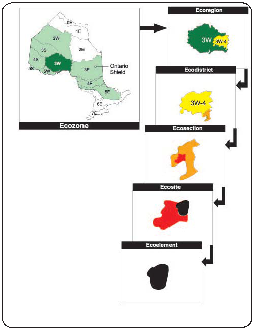
Figure 1: The levels in the Ontario Ecological Land Classification hierarchy. Starting from the ecozone, the hierarchy moves down to the ecoregion, then to the ecodistrict, then to the ecosection, then to the ecosite, and then to the ecoelement.
Enlarge The levels in the Ontario Ecological Land Classification hierarchy.
This report contains two sections. The first, introductory section provides information on the approach used to classify ecosystems at the two upper levels of the ELC hierarchy and presents a brief overview of the evolution of the provincial ELC. A table outlining all levels of the provincial ELC, how they are characterized, primary application, and common map scale can be found in Appendix 1, and a more detailed discussion of the ELC hierarchy can be found in Uhlig et al. (in prep). Section two describes the characteristic features of the ecozones in Ontario and their ecoregions. Images of representative ecosystems, landscapes, and species supplement the descriptions. In addition, a summary of ecoregional attributes such as primary bedrock, mean annual temperature, primary substrate type, etc., is presented for each ecoregion in Appendix 2.
Percent area for each substrate was derived by overlaying soil polygons (from Soil Landscapes of Ontario, Version 2) on ecoregion boundary maps.
The size (area and percentage) of each ecozone and ecoregion was determined through ArcGIS analysis of Provincial Landcover 2000 (0E – 5S) or 1990 Landcover 28 (6E – 7E) data. This area is based on the terrestrial land occupied by each and does not include the Great Lakes. Please refer to Spectranalysis Inc. (1999, 2004) for information on how each landcover class was interpreted.
Examples of some of the natural heritage areas located in each ecoregion was obtained from Gray et al. (2009). More than 40 types of natural heritage areas – some with many sub-categories – now comprise a diverse array of sites across Ontario. The phrase ‘natural heritage area’ is used to denote the family of strictly protected areas (e.g., National Parks, Provincial Parks, and Conservation Reserves) and other designations (e.g., Migratory Bird Sanctuaries) that collectively contribute to the maintenance and enhancement of Ontario’s biodiversity. A detailed description of each type of natural heritage area in Ontario is available in Gray et al.>(2009).
A glossary of scientific terms and a list of common and scientific names of the plant and animal species mentioned in this report can be found in Appendix 3 and 4. Scientific and common names are consistent with Natural Heritage Information Centre (NHIC) naming conventions.
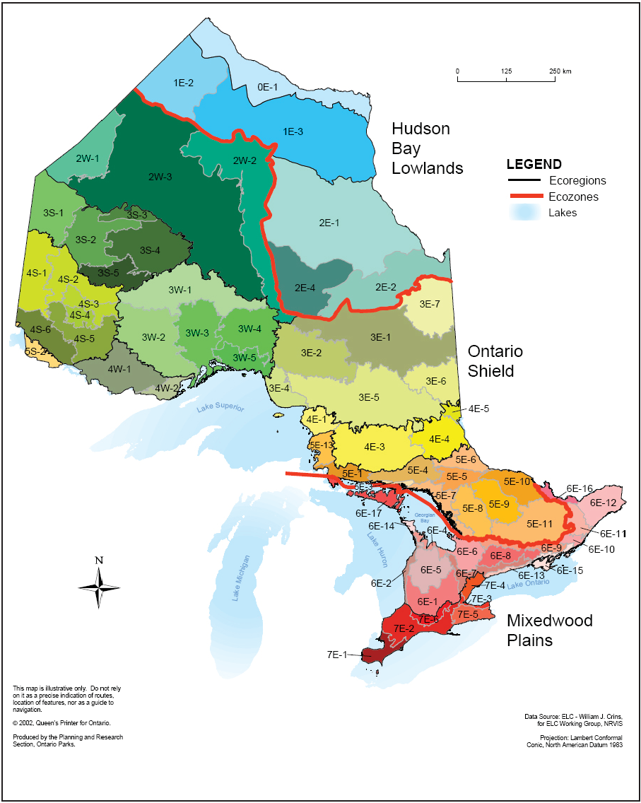
Figure 2: The ecozones, ecoregions, and ecodistricts of Ontario.
Enlarge Figure 2
Section 1
Development of Ontario’s Ecological Land Classification (ELC) Ecozones and Ecoregions, and rationale for revisions
Ecozones are the highest level of ecosystem classification in Ontario. Their boundaries are based on key abiotic processes functioning at global and continental scales within which human and ecosystem functions are defined and constrained. Based on an analysis of ecosystem composition, structure, and function at national (Wiken, 1986) and continental (Bailey, 1998; CEC, 1997) scales, the level of ecozone (with small refinements to the boundaries of the ecozones contained in the national ELC) was added to Ontario’s ELC in 2000 (Crins, 2000; Crins and Uhlig, 2000). This addition recognized the need for more explicit links to national and continental ELCs for reporting purposes, facilitated a sound ecological perspective for management and planning, incorporated a variety of information sources and expert advice from various sources, and provided a tool to describe and map at different levels in the ecosystem hierarchy. Of 15 terrestrial ecozones in Canada, the Hudson Bay Lowlands, the Ontario Shield, and the Mixedwood Plains Ecozones occur in Ontario.
Ecoregions, which capture major subdivisions in Ontario primarily identified by sub-continental climatic regimes combined with bedrock geology, were first categorized by Angus Hills in the 1950s. In 1959 Hills completed his first comprehensive version of the provincial ELC system, defining ecosystems at the ecoregional and ecodistrict levels, using macroclimate, landform, and substrate. This work was at the leading edge of ecosystem regionalization (mapping large ecosystems) in Canada at the time. He continued to revise this system until 1976. In addition to describing Ontario’s large ecosystems using regionalization techniques, he completed a sizeable body of work designed to classify and describe smaller ecosystems at the site and stand levels (Hills, 1961, 1964, 1976). Hills’ classification system (1959) was formally adopted by the Ontario Ministry of Natural Resources (OMNR) in 1978 and reaffirmed in 1989. That system (Hills, 1961; reprinted in 1966 with a revised map) continues to form the basis for ecological classification in Ontario today.
In the 1990s, Burger (1993) proposed revisions to some of the ecoregion boundaries. Based on his proposal, Ecoregion 0E along the Hudson Bay coast was added, Ecoregion 5S in the Kenora-Lake of the Woods area was decreased in size, and the boundaries of Ecoregions 3S, 3W, 4S, and 4W were modified. Like Hills, Burger placed heavy emphasis on vegetation successional patterns on similar physiographic sites.
Recent and current policies, directives, and projects employ an ecological context, including ecoregions and/or ecodistricts (e.g., Ontario’s Living Legacy Land Use Strategy, Forest Management Planning Manual, Old Growth Policy, State of the Forest Report, Oak Ridges Moraine Conservation Plan, and Natural Spaces), requiring consistent, interpretable ecosystem boundaries for natural resource management decisions. In addition, broad ministry direction includes the requirement to use the best available science and to use an ecosystem approach to resource management (OMNR, 2005b). Thus, the smooth, generalized lines used by Hills did not adequately capture the spatial resolution needed for gap analysis, protected area stratification, state of resource reporting, or GIS applications. Recently, new data and new analytical tools have become available for use in the delineation and interpretation of broad ecological units, including improved geological and remotely sensed land cover mapping and climate models. In recognition of the changing policy requirements and analytical tools that were emerging, and in order to correct earlier transcription errors, revisions to many of the ecosystem boundaries within Hills’ system began in the mid 1990s, when revisions to the ecoregion and ecodistrict boundaries in southern Ontario were completed by Jalava et al. (1997). Subsequent to that work, the remainder of the ecozone, ecoregion, and ecodistrict boundaries were revised to improve consistency within the system as a whole, and those revisions are reflected in Figure 2 (Crins 2000, with minor cartographic revisions in 2002).
Revisions to the ecozone and ecoregion boundaries will likely be necessary as new sources of data become available and the ability to interpret the data is improved. In addition, the significant and complex effects that climate change exerts at all scales of the ecosystem hierarchy will need to be represented in future iterations of the ELC.
In the present ELC, the two upper levels of the hierarchy are defined as follows (also see Appendix 1):
Ecozone: A very large area of land and water characterized by a distinctive bedrock domain that differs in origin and chemistry from the bedrock domain immediately adjacent to it. The characteristic bedrock domain, in concert with long-term continental climatic patterns, has a major influence on the ecosystem processes and biota occurring there. This scale in the ecological classification hierarchy is resilient to short-term and medium-term change, and responds to global or continental cycles and processes operating on the order of thousands to millions of years.
Ecoregion: A unique area of land and water nested within an ecozone that is defined by a characteristic range and pattern in climatic variables, including temperature, precipitation, and humidity. The climate within an ecoregion has a profound influence on the vegetation types, substrate formation, and other ecosystem processes, and associated biota that live there.
Section 2
Hudson Bay Lowlands Ecozone
This northernmost ecozone constitutes Ontario’s portion of the Hudson Plains Ecozone described in the national ELC system (Wiken, 1986). It forms the core of the third largest wetland in the world (Abraham and Keddy, 2005), encompassing about 25% (24,804,611 ha) of Ontario and its boundary (slightly refined from that in the national system), conforms to the contact zone between the Phanerozoic (Ordovician to Cretaceous) limestones and the Precambrian Shield, and includes the limestone bedrock along the coasts and inland from Hudson Bay and James Bay, but excluding the Precambrian Shield (Shilts, 1982). Moosonee, Moose Factory, Attawapiskat, Peawanuck, and Fort Severn are located in this ecozone. It also contains Ontario’s largest protected area, Polar Bear Provincial Park. Furthermore, it is the only ecozone in the province that is adjacent to, and influenced by, salt water and tides, through Hudson and James Bays (Stewart and Lockhart, 2005). At the national level, this ecozone extends north and west into Manitoba, and eastward a short distance into Quebec.
The climate is relatively cold and semi-arid, the winters are long and cold, with mean daily January air temperatures between -20 and -27.5°C, and the summers are short and cool, with mean daily July air temperatures from 12 to 16°C. Average annual precipitation ranges between 240 and 525 mm (Stewart and Lockhart, 2005). The percentage of incoming solar radiation that is reflected from the surface by snow, ice, wet surfaces, fog, and cloud over Hudson and James Bays is high (Stewart and Lockhart, 2005). The presence of permafrost (continuous permafrost in Ecoregion 0E, discontinuous permafrost in Ecoregions 1E and 2E) affects summer climate, since it prevents moisture penetration into the substrate, and energy is expended evaporating that moisture, rather than increasing air temperatures (Stewart and Lockhart, 2005). Clear evidence of climate change exists in the form of decreasing duration of sea ice cover in portions of Hudson and James Bays over the past few decades (Stewart and Lockhart, 2005).
The ecozone constitutes that portion of the province north of the Precambrian Shield where the underlying bedrock is limestone derived from ancient marine seabed deposits. This area coincides fairly closely with the Hudson Bay Lowlands Section of the Boreal Forest Region (Rowe, 1972). The topography throughout the ecozone is extremely flat. In local areas, such as the Sutton Ridges, local exposures of sandstone, shale, and Precambrian rocks rise above the predominantly limestone bedrock landscape. Minor morainal ridges and long eskers provide local relief in the otherwise subdued topography. Marine deposits of clay and beach materials continue to accumulate along the coastal margins of Hudson and James Bay. The near-coastal saline substrates are unique within the province. Over much of the landscape variable depths of glacially deposited lacustrine (fine silts, clays) and morainal materials blanket the surface. The very subdued topography has encouraged the development of vast wetlands with their associated organic substrate accumulations – often many metres deep. Large rivers (e.g., Albany and Winisk) have cut channels and gorges across the broad landscape.
This ecozone emerged from the Laurentide Ice Sheet approximately 8,500 - 6,500 years before present, with the sea flooding in to cover it almost completely. The modern landscape has slowly emerged from the sea as a result of isostatic rebound, evolving from coastal lowland to elevated interior. Along the coasts, the rates of land emergence remain the highest in North America, though far lower than in the period immediately after deglaciation. After emergence, the initial mineral weathering and accumulation of surface organics begins within about 200 years (Protz, 1982a, Stewart and Lockhart, 2005), with an initial upland vegetation of sparse tundra northward, and ridge thickets southward. These succeed generally to shrub birch, Canada buffalo-berry, heaths and willows, then after a millenium or so, to spruces, tamarack, alders, and Sphagnum spp., a pattern that has been consistent since the lowland first emerged (McAndrews et al.., 1982). Substrates (soils) are only weakly matured due to cold and saturated conditions. Most common are Orthic Regosols, Cryosols, Orthic and Humic Gleysols, and Orthic Humo-ferric Podzols (Ecoregions Working Group, 1989; Protz, 1982a, b). Discontinuous permafrost occurs in the southern portion of the ecozone. Well expressed frozen (cryosolic) substrates become increasingly common in more northerly areas (Riley, 2003).
Drainage in this ecozone is poor, with much standing or slowly moving water. Riley (2003) estimates 90% of the landscape is dominated by saturated peatland plains in the Hudson Bay Lowlands. Major river systems include the Severn, Winisk, Ekwan, Attawapiskat, Albany, Moose, Abitibi, and Harricanaw Rivers and their tributaries. There are few large lakes, except in the vicinity of bedrock outcrops (e.g., Sutton and Aquatuk Lakes).
The origin of much of the boreal forest throughout the Hudson Bay Lowland Ecoregion is through fire. Stand structure is also affected by wind, insect infestations, and beaver activity.
There are globally significant wetlands comprised of open and treed fens, bogs, and palsas in this ecozone. Marshes develop in supratidal areas. Sedge fens, sometimes with a low woody component of dwarf birch and various willow species, are evident near the coast and among the coniferous forests (dominated by tamarack and/or black spruce) inland. On drier areas, herb-moss-lichen tundra develop near the Hudson Bay coast, and open upland coniferous forests (taiga) develop along river levees and old beach ridges throughout (Riley, 2003; Rowe, 1972; Wiken et al.., 1996). Predominant fauna include woodland caribou, moose, American black bear, American marten, sandhill crane, greater yellowlegs, lesser yellowlegs, solitary sandpiper, and blackpoll warbler. Arctic fox, snow goose, Smith’s longspur, and polar bear inhabit coastal areas during the ice-free period from late spring to early fall. Representative amphibians include American toad, boreal chorus frog, wood frog, and northern leopard frog. Inland streams and lakes contain brook trout, northern pike, and walleye. Marine mammals, such as beluga whales and walrus, occur in the waters adjacent to the ecozone, and utilize the mouths of the major rivers or islands just off the coast (Stewart and Lockhart, 2005). The ichthyofauna of the fresh waters in the ecozone is limited compared to other parts of the province, probably due to the relatively short period during which these waters have been free from glaciers. The lower reaches of the major rivers support populations of sea-run brook trout and arctic char is also known from a few locations (Scott and Crossman, 1973). Threespine stickleback is found only in this ecozone and in the Mixedwood Plains Ecozone, being absent from the Ontario Shield. Other fish species found throughout the ecozone include widespread species such as lake sturgeon, fathead minnow, white sucker, burbot, and mottled sculpin.
The human population in this ecozone is small. Major occupational and economic activities include hunting, trapping, fishing, and resource-based tourism, although mineral exploration and mining, particularly for diamonds, is increasing. Some of the major river systems have been altered for hydro-electric development.
Climate change is affecting the distribution and abundance of species in this ecozone. For example, the impacts of climate warming on polar bear populations may occur first near the southern edge of the range in James Bay and Hudson Bay. Obbard et al.. (2006) have already detected a decline in body condition, which in part, has been linked to changing sea ice dynamics and access to prey.
Ecoregion 0E (Hudson Bay Coast Ecoregion)
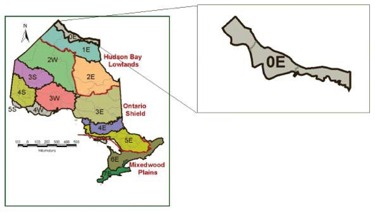
The Hudson Bay Coast Ecoregion extends from the Manitoba border east to Cape Henrietta Maria, and a variable distance inland (between 8 and 35 km) from the Hudson Bay coast. This subarctic ecoregion encompasses 2,827,893 ha (2.9% of the province).
Climate
The climate falls within the Low Subarctic Ecoclimatic Region (Ecoregions Working Group, 1989) and is characterized by short, cool summers and long, very cold winters. The growing season (frost-free period) is less than 65 days, due in part to exposure from cold northerly winds flowing over the Hudson Bay pack ice that often remains well into July (McAndrews et al.., 1982). Extensive fog results from contact between warm summer air and pack ice. The mean annual temperature ranges between -5.1 and -2.2˚C, the mean annual precipitation is 490 to 614 mm, and the mean summer rainfall is 204 to 250 mm (Mackey et al.., 1996a, b).
Geology and substrates
The underlying bedrock consists of Paleozoic (mainly Silurian, some Devonian) dolomite, limestone, siltstone, and sandstone. The surface terrain is very weakly broken, comprising a very flat plain with occasional incised river valleys running roughly perpendicular to the coast and with low raised beach ridges running parallel to the coast. This plain consists primarily of deep, calcareous, marine clay deposits originating from the post-glacial Tyrrell Sea, often overlain with fibric peat deposits (up to 4 m thick) (Riley, 2003). Sands and silts are also found here, particularly on the numerous beach ridges and strandlines resulting from isostatic recovery which continues to this day.
A diagnostic feature of this ecoregion is the presence of continuous permafrost, which controls substrate formation and hydrological dynamics on most of its landscape. Of concern is the susceptibility of permafrost to a warming climate and its potential effect on fish and wildlife habitat.
Substrate development is limited in this ecoregion due to the very young age of the parent materials and cold climate. Most substrates are Fibrisols formed from sedge and moss peats (48%). Organic Cryosols formed from sedge and fibrous Sphagnum peats (26%), Eutric Brunisols (6%) formed on calcareous well drained sites, and Regosols (5%) on silty and clayey marine sediments along the coast constitute the other major substrate types. The potential capability of mineral substrates to buffer the acidity from atmospheric deposition is high in this ecoregion due to the calcareous parent materials (Environment Canada, 1988).
Land cover
Wetlands (primarily open and treed fen, open bog, and palsa
As would be expected given the cool, humid coastal climate, occurrence of permafrost and extremely limited tree cover in the ecoregion, major fires are infrequent. However, small fires do occur from time to time in treed patches.
Water
The Hudson Bay Coast Ecoregion is dominated by water, through very poor to poor drainage of most substrates, extensive shallow lake and pond systems, and several major river systems with their dendritic tributary systems, as well as the tidal coast of Hudson Bay and the extreme northwestern coast of James Bay. Important river systems traversing the area include the Black Duck, Niskibi, Severn, Shagamu, Winisk, Sutton, and Kinushseo Rivers. The entire ecoregion is located in the Hudson Bay Watershed. The formation of large bodies of water is hindered due to the flat topography and drainage of the ecoregion.
Flora and fauna
Ecoregion 0E is contained within the Boreal Forest Region. The Forest-Tundra Forest Section and a portion of the Hudson Bay Lowlands Forest Section are also located here (Rowe, 1972). The vegetation is characterized by lichen heath with forest tundra (Bates and Simkin, 1966). Floristically, the ecoregion has mixed affinities, containing both boreal and arctic species (many of these being transcontinental in distribution). Riley (2003) referred to the larger part of this ecoregion as the Maritime Tundra (Low Arctic) Floristic Zone, with a smaller, more inland portion belonging in the Peat Plateau and Woodland Floristic Zone. Floristically, the Maritime Tundra Floristic Zone is one of the most distinct zones in the entire Hudson Bay Lowlands Ecozone (Riley, 2003).
Immediately adjacent to the coast, extensive salt marshes develop. Dominant plants include dwarf and shrub willows, sedges, blueberries and relatives, Labrador teas, avens, and various legumes (e.g., milk- and sweet-vetch and oxytropes). In many areas on river levees and sheltered beach ridges, black spruce, white spruce, and tamarack are common; these species occur in stunted form on the more exposed sites (Rowe, 1972; Stewart and Lockhart, 2005).
The fauna of this ecoregion has its main affinities with areas to the north, although like the flora, there is a mixture of boreal and arctic species. This ecoregion provides important denning and summering sites for polar bear, and the river mouths immediately off-shore in Hudson Bay are focal areas for pods of beluga whales. Woodland caribou are wide spread, and arctic species such as arctic fox inhabit the area. Breeding shorebirds such as Hudsonian godwit, whimbrel, dunlin, semipalmated sandpiper, and semipalmated plover use the peatlands and beach ridges. Pacific loon, red-throated loon, tundra swan, snow goose, long-tailed duck, greater scaup, and other waterbirds characteristic of Arctic regions breed here. This area also supports healthy populations of tundra and tree-line songbirds, such as Smith’s longspur, lapland longspur, American tree sparrow, and common redpoll. Amphibians found in the ecoregion include American toad, boreal chorus frog, wood frog, and northern leopard frog.
The river systems in the ecoregion support populations of sea-run brook trout, and this is the only part of the province in which Arctic char occur. Threespine stickleback, lake chub, pearl dace, walleye, johnny darter, and slimy sculpin are among the characteristic species inhabiting the fresh water.
Land use
The population in this ecoregion is comprised almost entirely of First Nations peoples. Fort Severn is the primary community. Hunting, trapping, fishing, and guiding/ outfitting services are primary activities. Some mineral exploration is occurring.
There are six types of natural heritage areas in Ecoregion 0E, including Polar Bear Provincial Wilderness Class Park, Cape Henrietta-Maria Wilderness Area, Pen Islands Area of Natural and Scientific Interest, and Sutton River Coastline Important Bird Area.
Ecoregion boundary delineation and rationale
Although phytogeographic and ecoclimatic regions have been recognized here for some time, and Hills (1961) recognized ecodistricts along this coast, it was first proposed as a distinct ecoregion by Burger (1993). The boundary of this ecoregion has been interpreted from high-level satellite imagery, which clearly shows the limits of the zone of continuous permafrost (Brown, 1973) and the limited amount of treed vegetation. The southern edge of the ecoregion is approximated by the 360 mm potential evapotranspiration isopleths (Ahti, 1964; Hare, 1954) and the 10°C June isotherm (Hare, 1950). The northern boundary of Ecoregion 0E is formed by the tidal coast of Hudson Bay. A very short stretch of the northwestern James Bay coast is also found in this ecoregion. The attributes that define this area coincide with floristic patterns observed on the landscape.
Ecoregion 1E (Northern Taiga Ecoregion)
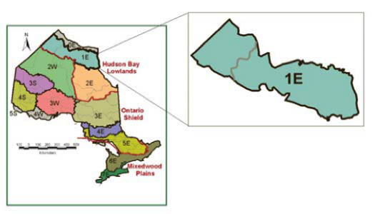
The Northern Taiga Ecoregion forms a band of land from the Manitoba border to the north-central portion of the James Bay coast. It occupies 9,482,319 ha (9.6% of the province).
Climate
The climate of this ecoregion has been classified within the Low Subarctic Ecoclimatic Region (Ecoregions Working Group, 1989). It has short, cool summers and long, very cold winters. The mean annual temperature range is -5.1 to -2.2˚C, the mean length of the growing season is 138 to 157 days, the mean annual precipitation is 490 to 614 mm, and the mean summer precipitation is 204 to 250 mm (Mackey et al., 1996a, b).
Geology and substrates
The Northern Taiga Ecoregion is underlain mainly by Paleozoic (mostly Silurian and Upper Ordovician) bedrock composed of dolomite, limestone, siltstone, sandstone, and shale. The surficial landform pattern in the ecoregion is a nearly level plain of deep drift comprised of weakly and very weakly broken calcareous glaciomarine clays, silts, and sands deposited from the post-glacial Tyrrell Sea (Barnett, 1992). There is a prominent exception to this relatively flat landscape. The Sutton Ridges are a continuous grouping of metasedimentary inliers (with some gneissic, granitic, and diabase components) in the mid-northeastern portion of the ecoregion. In addition, a few inliers occur almost as far west and north as Peawanuck.
Discontinuous permafrost is characteristic of this ecoregion. Due to the subdued topography most substrates are very poorly drained and peatlands and many small lakes exist across the entire landscape (overlying the glaciomarine deposits). Fibric and mesic peats develop over the clay, silt, and sand overburden, and generally are shallower than peat formations located further south, due to the lower annual growth increment. Substrates may be calcareous or not, depending on the source of the parent materials. Virtually all of the substrates in this ecoregion fall into two Great Groups, Fibrisols (47%) and Organic Cryosols (43%). Eutric Brunisols (4%) associated with well drained marine and till upland deposits and Mesisols (4%) that develop where drainage is impeded are also found. The substrates in most of the ecoregion have not been rated for their potential to reduce acidity from atmospheric deposition (Environment Canada, 1988). However, it seems likely that this potential is high, given the calcareous bedrock and extensive underlying clay deposits (but not necessarily at the surface) in the ecoregion.
Land cover
The predominant land cover types in this ecoregion are treed (23.9%) and open (23.8%) bog, sparse forest (15.5%), treed (11.4%) and open (9.8%) fen, and water (7.4%).
Few large fires have been recorded in this ecoregion, probably due to the cool humid climate and predominance of wet substrates. A number of the fires recorded in recent decades have occurred on or adjacent to the Sutton Ridges, where conditions are much drier and better drained.
Water
Most of the ecoregion is covered by peatlands and small lakes. Drainage is generally very poor due to the shallow gradient of the terrain and the low permeability of the substrates. Wetlands generally constitute 76 to 100% of the landscape. The ecoregion is situated within the Hudson Bay Watershed and contains major reaches of several large river systems, including the Severn, Winisk, Sutton, Kinushseo, Lakitusaki, Opinnagau, and Ekwan Rivers. Of these, it contains the mouths of only the latter three rivers at James Bay. All of the other rivers flow to Hudson Bay through the adjacent Hudson Bay Coast Ecoregion. The ecoregion contains several lakes associated with the Sutton Ridges, including Sutton, Hawley, and Aquatuk Lakes, as well as Opinnagau Lake south of the ridges.
Flora and fauna
This ecoregion forms a portion of Rowe’s (1972) Hudson Bay Lowlands Forest Section, within the Boreal Forest Region. Riley (2003) referred to the larger portion of this ecoregion as the Peat Plateau and Woodland Floristic Zone, and recognized the more southerly portion as the Peatland and Woodland Floristic Zone. The shift in floristic affinities is more gradual and less distinct compared to other floristic zones. The vegetation is predominantly open boreal forest (spruce-lichen woodland and taiga), with closed stands of black spruce along the more deeply entrenched stream courses with levees comprised of mineral substrate. Open stands of white spruce with an ericaceous shrub and lichen layer grow on some drier sites. Major shrubs in the ecoregion include dwarf birch, various willows, and Labrador tea. The region also has been described as muskeg woodland (Coombs, 1952) and northern boreal forest (Ahti, 1964). Salt marshes have formed along the James Bay coast.
The fauna in this ecoregion is similar to that in Ecoregion 0E, except that tundra and tree-line species are less prominent. Woodland caribou, snowshoe hare, Canada goose, sandhill crane, various shorebirds, yellow rail, Bonaparte’s gull, blackpoll warbler, Connecticut warbler, palm warbler, boreal chickadee, gray jay, and Nelson’s sharp-tailed sparrow are representative terrestrial vertebrates. American toad, boreal chorus frog, wood frog, and northern leopard frog are characteristic amphibian species found in this ecoregion. Fish such as pearl dace, longnose sucker, brook stickleback, and spoonhead sculpin inhabit rivers and lakes.
Land use
The primary community in this ecoregion is Peawanuck. The primary activities in this ecoregion include hunting, trapping, and fishing. Considerable mineral prospecting and some mining activity is now occurring, especially in the area north and west of Attawapiskat.
Seven types of natural heritage areas are located in Ecoregion 1E, including the Winisk River Alluvial Islands International Biological Programme Site, Winisk River Provincial Waterway Class Park, and Sutton Lake Gorge Wilderness Area.
Ecoregion boundary delineation and rationale
Burger (1993) recommended that the original ecoregion described by Hills (1959, 1964) be divided into this ecoregion and the Hudson Bay Coast Ecoregion. Burger’s (1993) proposed split, adopted here, makes the Northern Taiga Ecoregion more homogeneous. This area is characterized by discontinuous permafrost, and is bound on its southwestern end by the contact zone with Precambrian Shield, and on its southeastern end by a temperature transition with the adjacent Ecoregion 2E.
Ecoregion 2E (James Bay Ecoregion)
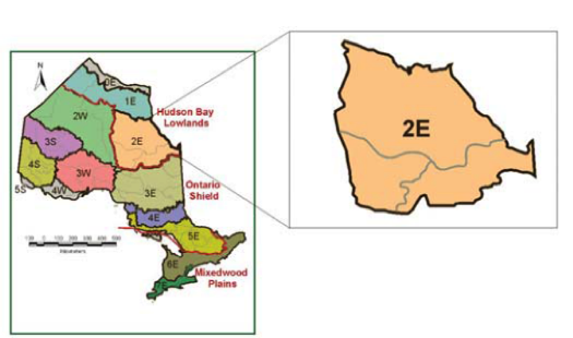
Ecoregion 2E extends from north of the Attawapiskat River south along, and inland from, James Bay to the Quebec border, including much of the lower Moose River drainage. It encompasses about 12.7% (12,494,468 ha) of the province.
Climate
The James Bay Ecoregion climate is part of the Perhumid High Boreal Ecoclimatic Region (Ecoregions Working Group, 1989). The mean annual temperature ranges from -2.6 to 0.5˚C, the mean length of the growing season is 154 to 173 days, the mean annual precipitation is between 528 and 833 mm, and the mean summer rainfall is between 221 and 286 mm (Mackey et al., 1996a, b).
Geology and substrates
The ecoregion is underlain by Phanerozoic (Ordovician, Silurian, Devonian, and to a much lesser extent, Cretaceous) dolomite, limestone, siltstone, sandstone, and shale. Landscapes tend to consist of level plains, with numerous shallow ponds interspersed among the peatlands and river systems. The overburden is comprised of deep, calcareous glaciomarine clays, silts, and sands, over which peat deposits often develop (Barnett, 1992).
Fibrisols constitute the dominant class of substrates (89% of the landscape), and Mesisols (4%) and Gleysols (3%) cover the rest of the ecoregion. Though only a small part of the ecoregion, Gray Luvisols, Dystric and Eutric Brunisols, and Humo-ferric Podzols develop where better drainage occurs. Permafrost is sporadic and discontinuous (Stewart and Lockhart, 2005). The capacity of substrates to reduce acidity from atmospheric deposition has not been rated in most of the ecoregion (Environment Canada, 1988). However, given the calcareous bedrock and clay surficial deposits, it seems likely that this capacity is high in most portions of the ecoregion.
Land cover
Treed and open fen (22.3% and 7.3%) and treed and open bog (21.2% and 17.7%) comprise the primary vegetation associations in the James Bay Ecoregion. Coniferous forest is the predominant forest class (12.6%) followed by sparse forest (7.6%). Open water covers 5.6% of the area. This ecoregion notably includes the most extensive treed fens in the ecozone and in Ontario particularly in the Moose River basin, providing some of the finest American marten habitat in Ontario.
The predominance of wet organic substrates and a cool humid climate result in very few major fires. Small fires occur from time to time.
Water
The relatively flat landscape results in very poor drainage and extensive peatlands throughout the area. Several large river systems traverse the ecoregion and drain into James Bay, part of the Hudson Bay Watershed, including the Attawapiskat, Kapiskau, Albany, Abitibi, Harricanaw, and Moose Rivers. Lakes in the ecoregion include Jog, Pledger, Missisa, and Kapiskau Lakes.
Flora and fauna
This ecoregion comprises a portion of Rowe’s (1972) Hudson Bay Lowlands Forest Section, within the Boreal Forest Region. Its vegetation is predominantly comprised of relatively stunted stands of black spruce and tamarack interspersed with open fens and bogs. More fully developed stands of coniferous and mixedwood boreal forest develop only on well-drained, but not exposed, ridges, along the levees of streams and rivers, and in protected valleys (Hills, 1959). Riley (2003) referred to the larger portion of this ecoregion as the Boreal Peatland Floristic Zone, and considered it to be quite distinct from the other floristic zones in the Hudson Bay Lowlands. However, he also recognized a distinctive narrow coastal band within the ecoregion as the Southwest James Bay Floristic Zone, characterized by species associated with salt marshes, freshwater estuaries, and coastal beach ridges (Riley, 2003; Riley and McKay, 1980).
The James Bay coastal tidal flats are globally important for staging shorebirds, particularly during their southbound fall migration. Large numbers of species such as Hudsonian godwit, semipalmated sandpiper, and white-rumped sandpiper stop here to feed on the abundant invertebrates in the coastal sediments. This ecoregion supports substantial populations of yellow rail, Connecticut warbler, Nelson’s sharp-tailed sparrow, and numerous other peatland and boreal bird species. Woodland caribou, American black bear, snowshoe hare, Canada lynx, American marten, and eastern red-backed vole are representative mammals of the ecoregion. Amphibians and reptiles include blue-spotted salamander, American toad, boreal chorus frog, wood frog, and eastern gartersnake. Characteristic fish species include white sucker, burbot, johnny darter, and logperch.
Land use
Attawapiskat, Fort Albany, Kashechewan, Moosonee, and Moose Factory are located in this ecoregion. Mining activity has increased over the past decade, with the discovery of diamonds and other minerals near the Attawapiskat River. Hunting, trapping, fishing, guiding, and remote outdoor activities, as well as support services for the communities (e.g., transportation links by water, rail, and air) are major components of the economy.
Ecoregion 2E encompasses 13 types of natural heritage areas, including the Southern James Bay Ramsar Convention Site, Kesagami Provincial Wilderness Class Park, Missinaibi Provincial Waterway Class Park, and Jog Lake Conservation Reserve.
Ecoregion boundary delineation and rationale
The western and southern boundaries of the ecoregion coincide with the Phanerozoic/ Precambrian bedrock interface (Ontario Geological Survey, 1991; Shilts, 1982). Although most of the bedrock in this ecoregion is of Paleozoic age (Ordovician, Silurian, Devonian), this is the only area in the province where bedrock of Cretaceous age exists (Baldwin et al., 2000; Shilts, 1982). Hills (1959) included the Kesagami ecodistrict within this ecoregion, but it has been re-assigned to Ecoregion 3E because it is subtended by Precambrian bedrock and climate modeling indicates closer affinities with the adjacent ecodistricts in Ecoregion 3E than with those in Ecoregion 2E (D. Joyce, pers. comm.). In addition to the sharp boundary between bedrock types at the Ecoregion 2E/3E boundary, there is a sharp difference in the estimated net primary productivity across this boundary (Baldwin et al., 1998).
Ontario Shield Ecozone
The Ontario Shield Ecozone comprises Ontario’s portion of the national Boreal Shield Ecozone (Wiken 1986). In Ontario, we use the term “Ontario Shield” because the ecozone includes true boreal forest as well as substantial portions of the non-boreal Great Lakes–St. Lawrence Forest Region (Rowe, 1972). This ecozone occupies more than half of Ontario (65,336,847 ha, 66.2%), and extends from the contact zone with the Hudson Bay Lowlands and its Paleozoic limestone in the north to the limestones and related younger rocks of the Mixedwood Plains Ecozone in the south. Nationally, the ecozone extends well into Manitoba and Quebec.
In a continental context, the climate in this ecozone is relatively cold and moist, with long, cold winters and short, warm summers. However, there is a wide range of temperature, precipitation, and humidity patterns. Precipitation ranges from about 500 mm per year in the west to 850 mm per year in the east (Ecoregions Working Group, 1989). The mean daily temperature in January is about -15 °C, and the mean daily temperature in July is around 17°C (but conditions are more moderate in the southern part of the ecozone and adjacent to the Great Lakes).
With the exception of local outliers, this ecozone contains all of the Precambrian bedrock in the province. These rocks tend to be gneisses and granites, but basalts, greenstones, and many other mineral types also occur. The surficial geology is diverse, and includes morainal, organic, and glaciolacustrine deposits, as well as numerous eskers and drumlins. Substrates are also diverse. In deeper mineral material Podzols and Brunisols dominate, but it is important to note that a significant percentage of the Ontario Shield Ecozone is comprised of exposed bedrock. The topography is varied, depending on both local bedrock and surficial deposits. Lakes and rivers are frequent in many parts of the ecozone. Drainage patterns are complex and dependant on local topography and landforms. Some of the numerous river systems found in this ecozone, in whole or in part, include the Severn, Pipestone, English, Rainy, Winisk, Attawapiskat, Pigeon, Nipigon, Albany, Missinaibi, Moose, Abitibi, Montreal, St. Mary’s, Batchawana, Goulais, Mississagi, Spanish, French, Ottawa, Mattawa, Petawawa, Madawaska, and Muskoka Rivers. Many of these river systems have their sources within the ecozone, which contains the divide between the Hudson Bay and Great Lakes Watersheds.
In the conifer-dominated boreal forests in the central and northern parts of the ecozone, as well as in pine and oak forests in the southern part, fire is a dominant force of natural change. Frequency, intensity, and size of burns vary, depending on climate, predominant forest type, and local landscape features (Thompson, 2000). Wind and insects also are important forces of change. In the tolerant hardwood forests growing in the southern part of the ecozone natural succession is facilitated through the creation of small gaps as older trees die and fall. These gaps are important in determining the composition, structure, and dynamics of the ecosystems. In aquatic ecosystems the beaver is an important ecological engineer.
Vegetation in the ecozone is diverse. Coniferous forests composed of spruce species, balsam fir, jack pine, tamarack, and intolerant hardwoods including white birch and poplars predominate in the northern part of the ecozone. In the south, mixed and deciduous forests of tolerant hardwoods (e.g., sugar maple, American beech) are more frequent. Wetlands, including peatlands, are abundant. Faunistic and floristic diversity are high, and are comprised of northern and southern elements. Woodland caribou, white-tailed deer, moose, American black bear, gray wolf, eastern wolf, Canada lynx, American marten, red squirrel, barred owl, boreal owl, white-throated sparrow, pileated woodpecker, wood warblers, blue jay, and gray jay are among the characteristic terrestrial fauna inhabiting the ecozone. Amphibians and reptiles include boreal chorus frog, American toad, spring peeper, northern leopard frog, blue-spotted salamander, western painted turtle, and northern red-bellied snake. In aquatic environments, lake trout, ninespine stickleback, northern pike, northern redbelly dace, yellow perch, and walleye are found.
Many towns and villages are located in this ecozone, but few have populations greater than 50,000 people. Thunder Bay, Sault Ste. Marie, Sudbury, Timmins, and North Bay are the largest communities. The major occupational and recreational activities in the ecozone include forestry, mining, resource-based tourism, hunting, trapping, and fishing. In terms of the spatial extent of resource management influence, forestry is by far the most extensive. Hardrock mining is a principle economic activity throughout the central and northern part of the ecozone. Hydro-electric facilities have been constructed on a number of the river systems.
It is anticipated that the range limits for southern species will expand northward in response to warmer temperatures. For example, warmer lake temperatures will reduce thermal habitat for cool and cold water fish species like walleye and lake trout in some areas and increase thermal habitat for warm water fish species like smallmouth bass (Kling et al.; 2003; Minns et al.., 2009). In terrestrial ecosystems, increased risk of higher fire severity and a longer fire season will change the natural disturbance regime in many types of forest (Wotton et al.; 2005). Changing disturbance patterns in conjunction with warmer temperatures and different precipitation patterns likely will result in the invasion and establishment of new, more southerly plant and animal species in northern ecosystems (Chiotti et al., 2007).
Ecoregion 2W (Big Trout Lake Ecoregion)

This large northwestern ecoregion encompasses 16.5% (16,303,215 ha) of Ontario. It borders Manitoba in the west, the Hudson Bay Lowlands Ecozone in the east and north, and extends south to Favourable Lake and the Albany River.
Climate
This ecoregion is located in a cold and dry part of the province. It has been classified within the Subhumid and Moist High Boreal Ecoclimatic Regions (Ecoregions Working Group, 1989). The climate is characterized by cool summers and long, cold winters, with a mean annual temperature ranging between -4.1 and -0.1˚C, a mean growing season length of 147 to 170 days, mean annual precipitation of 550 to 786 mm, and mean summer rainfall between 222 and 297 mm (Ecological Stratification Working Group, 1996; Mackey et al., 1996a, b).
Geology and substrates
Ecoregion 2W is situated on the Precambrian Shield, where the underlying bedrock is gneissic or granitic. The surficial geology is varied and includes extensive areas of exposed bedrock and ground moraine and associated terminal and interlobate moraines (Agutua-Windigo, Big Beaver House, and Sachigo). Extensive coverage of the area by portions of post-glacial Lake Agassiz has resulted in variable glaciolacustrine silt and silt clay deposits north of the Agutua-Windigo Moraine. The landscape tends to be weakly broken, with low ridges of clay and sand, and extensive peatlands in low-lying areas. It contains a mixture of acidic sandy tills and calcareous sandy to loamy, cobble tills.
On well-drained sites, base-rich Brunisols develop, but in most of the ecoregion, organic peaty substrates and Gleysols are found. The predominant substrate classes are: Mesisols (20%), Eutric Brunisols (17%), and Organic Cryosols (17%). Fibrisols (14%) and Dystric Brunisols (12%) are fairly widespread as well. Most substrates have a low to moderate capability to buffer the acidity of atmospheric deposition (Environment Canada, 1988).
Land cover
Sparse forest covers approximately 21.4% of the ecosystem. Coniferous and mixed forests grow on 19.4% and 8.4% of the area, respectively, and small pockets of deciduous forest grow along river valleys. More than 30% of the ecoregion is covered by various types of wetlands, including 12.1% water and 9.1% treed bog. Burns occupy 8.1% of the ecoregion, the highest percentage in Ontario.
This ecoregion is susceptible to fire, however they are generally smaller than those in more southerly ecosystems in northwestern Ontario. Throughout the western and central portions of the ecoregion, fires are fairly evenly distributed across the landscape, with the exception of the extreme northern fringe. However, in the eastern, wetter part of the ecoregion, burned patches are smaller and further apart. Upland coniferous forest fire cycles range between 50 and 187 years, and fires in these ecosystems tend to be stand replacing. Mixedwood and hardwood fire cycles range between 63 and 210 years, and the intensity of fires in these ecosystems tend to be much more variable (van Sleeuwen, 2006).
Water
This ecoregion is situated in the Hudson Bay Watershed. Major rivers such as the Sachigo, Severn, Fawn, Winisk, Albany, Attawapiskat, and Pipestone Rivers flow through the area en route to the coast. Several large lakes, including Sandy, Sachigo, Big Trout, North Caribou, and Wunnummin Lakes, are found in the ecoregion. With the exception of a few small deposits in the southwest portion, ground water retention in substrate overburden is limited and drainage varies from very poor to moderately well.
Flora and fauna
Portions of two forest sections of Rowe’s (1972) forest region classification are located in this ecoregion: the Northern Coniferous Forest Section (west) and the Central Plateau Forest Section (east). Both forest sections are within the Boreal Forest Region. This ecoregion comprises a substantial portion of Ontario’s boreal forest. Black spruce is the predominant forest tree on both upland and lowland sites. Jack pine and white birch are frequent associates of black spruce on upland sites. In addition, mixed stands of white spruce, black spruce, balsam fir, and poplar species develop on warmer-than-normal sites, usually on shores of lakes and large rivers (Hills, 1959). Fens and bogs with mosses, ericaceous shrubs, and graminoids predominate in lowland sites.
The fauna of this ecoregion is typically boreal, including such vertebrate species as gray wolf, American black bear, North American river otter, wolverine, American marten, beaver, woodland caribou, moose, snowshoe hare, eastern red-backed vole, spruce grouse, bald eagle, gray jay, palm warbler, white-throated sparrow, American toad, spring peeper, northern leopard frog, mink frog, and eastern gartersnake. Spottail shiner, finescale dace, fathead minnow, white sucker, brook stickleback, and mottled sculpin are among the fish species found in aquatic ecosystems in the ecoregion.
Land use
Most (about 98%) of the people in Ecoregion 2W live in First Nations communities. The largest community is Kitchenuhmaykoosib Inninuwug on the shores of Big Trout Lake. Trapping, hunting, fishing, and services associated with resource-based tourism are the primary occupations and land uses in the ecoregion. Mineral exploration is widespread and growing.
There are five types of natural heritage areas in Ecoregion 2W. Examples of natural heritage areas include Wabakimi and Opasquia Provincial Wilderness Class Parks, Kagianagami Lake Conservation Reserve, and Ogoki Provincially Significant Wetland.
Ecoregion boundary delineation and rationale
Climatic differences (particularly temperature) as well as surficial geology differ between Ecoregions 2W and 3S (Baldwin et al., 1998). The boundary between Ecoregions 2W and 3W is based primarily on temperature variables and estimated net primary productivity (Baldwin et al., 1998). There have been suggestions in the past that this ecoregion might be separable into two ecoregions, based mainly on differences in precipitation, with the western portion, adjacent to the Manitoba border, being drier. However, there are still too few data available to recognize another ecoregion here at the present time (Burger, 1993).
Ecoregion 3E (Lake Abitibi Ecoregion)
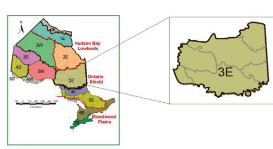
The Lake Abitibi Ecoregion is situated south of the Hudson Bay Lowlands Ecozone, from the Quebec border west to approximately Marathon. It encompasses 13,681,249 ha (13.9% of the province).
Climate
The climate in this ecoregion is included in the Humid Mid-Boreal Ecoclimatic Region (Ecoregions Working Group, 1989). Mean annual precipitation ranges between 652 and 1,029 mm, and mean summer rainfall is 220 to 291 mm. Winters are long, cold, and snowy, while summers are warm but short. The mean annual temperature range is -0.5 to 2.5˚C and the mean length of the growing season is between 167 and 185 days (Mackey et al., 1996a, b).
Geology and substrates
Ecoregion 3E is located on the Precambrian Shield, underlain by granitic or gneissic bedrock, with some areas of less acidic metavolcanic and metasedimentary rock. The surficial geology is diverse. The Clay Belt is prominent in the northeastern part of the ecoregion, and is situated on deep glaciolacustrine sediments of the former post-glacial Lake Barlow-Ojibway and on morainal calcareous clays and silts. Ground moraine is prominent in most other areas. Extensive low-lying areas of the landscape are overlain by organic deposits. In addition, end moraines, spillways, other glaciofluvial deposits, and substantial aeolian deposits are scattered throughout the ecoregion. The terrain is highly variable, ranging from weakly broken to strongly broken, depending on the surficial and bedrock features of the area, with the western portion being considerably more rugged than the eastern (especially northeastern) portion.
Substrates in the western and southeastern portions of the ecoregion are poorly developed. The varied and steep terrain in these areas yields rock outcrops with poor or no substrate development. The south-central and southeastern portions are blanketed with Humo-ferric Podzols (23%) developed on deep sands, rocky areas (13%) with forest cover, and scattered pockets of Brunisols (4%). Gray Luvisols (15%) are common in the north-central part of the ecoregion on well drained calcareous clay and silt plains, while Mesisols (24%) and Gleysols (18%) predominate in the northeastern part where drainage is poor.
A significant proportion of the substrates exhibit a high to moderate ability to buffer the impacts of acidic precipitation. However, nearly half of the ecoregion is draped in substrates with low buffering capacity, and these tend to be in the southern portion, closest to potential sources of acidification (Environment Canada, 1988).
Land cover
Mixed forest (29.5%), coniferous forest (28.1%), sparse forest (10.8%), and deciduous forest (7.2%) grow in this ecosystem. In addition, 7.8% is classified as cutover and water comprises 6.7% of the ecoregion.
The fire cycle in mixed forests ranges between 63 and 210 years, with fires in these ecosystems varying in intensity. Upland coniferous forests have a fire cycle between 30 and 187 years. Fires in these ecosystems tend to be stand replacing. Lowland coniferous forests have much longer fire cycles, ranging between 150 and 6,000 years (van Sleeuwen, 2006). These fires vary in intensity as well.
Water
The ecoregion contains a large number of meandering rivers, including the Kesagami, Abitibi, Mattagami, Groundhog, Kapuskasing, Missinaibi, White, and Michipicoten Rivers. A few large, shallow lakes, such as Lake Abitibi and Night Hawk Lake, are found in the northeastern portion of the ecoregion, and numerous small lakes are found in the western and southern portions of the ecoregion. Drainage is highly variable. The majority of the ecoregion is contained within the Hudson Bay Watershed. The south west portion of Ecoregion 3E is located in the Great Lakes Watershed.
Flora and fauna
Ecoregion 3E falls within Rowe’s (1972) Boreal Forest Region. Portions of at least four forest sections are located within this ecoregion (Northern Clay, Missinaibi–Cabonga, Central Plateau, and Superior). The vegetation in this ecoregion is boreal, with black spruce, white spruce, balsam fir, jack pine, tamarack, white birch, trembling aspen, and balsam poplar constituting the main forest species (Hills, 1959; Rowe, 1972). Species characteristic of the more southerly Great Lakes–St. Lawrence Forest Region, such as eastern white pine and red pine, grow on sandy ridges and other warmer-than-normal sites, and now tend to be found only in small, isolated pockets. American elm and eastern white cedar inhabit protected valleys (Hills, 1959).
As with the vegetation, the fauna of the ecoregion is typically boreal. Moose, gray wolf, Amercian marten, Canada lynx, snowshoe hare, red squirrel, beaver, and eastern red-backed vole are characteristic mammals. Common loon, great blue heron, bald eagle, osprey, spruce grouse, gray jay, common raven, Philadelphia vireo, Tennessee warbler, palm warbler, yellow-rumped warbler, Lincoln’s sparrow, white-throated sparrow, purple finch, and pine siskin are among the representative birds in the ecoregion. Amphibians and reptiles include spotted salamander, boreal chorus frog, wood frog, mink frog, midland painted turtle, and eastern gartersnake. Representative fish include brook trout, lake whitefish, northern pike, walleye, and yellow perch.
Land use
The larger communities within the ecoregion include Timmins, Cochrane, Chapleau, Kirkland Lake, Kapuskasing, Hearst, Iroquois Falls, Manitouwadge, Smooth Rock Falls, and Wawa. These communities depend primarily on forestry, mining, tourism, and trapping (OMNR, 1997). Timmins is the regional economic and industrial centre, with the largest population in the ecoregion.
Currently, 16 types of natural heritage areas are located in Ecoregion 3E, including Pukaskwa National Park, Missinaibi Canadian Heritage River, Nagagamisis Provincial Natural Environment Class Park, and the Chapleau Crown Game Preserve.
Ecoregion boundary delineation and rationale
The northern boundary of the ecoregion coincides with the Precambrian/Phanerozoic bedrock boundary and correlates with differences in estimated net primary productivity. The western boundary with Ecoregion 3W correlates with precipitation and temperature (Baldwin et al., 1998). The southern boundary coincides with several major end moraines (e.g., Chapleau Moraine) (Barnett et al., 1991a) and with temperature. The southern boundary also coincides approximately with the Hudson Bay Watershed, although portions of the Great Lakes Watershed are found in the western and extreme southeastern portions of the ecoregion, respectively.
Ecoregion 3S (Lake St. Joseph Ecoregion)
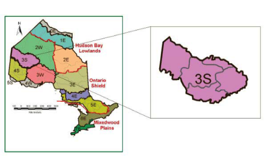
The Lake St. Joseph Ecoregion is located north of Red Lake and south of the Agutua-Windigo Moraine, including Trout Lake and Lake St. Joseph, and extends west to the Manitoba border. It encompasses 6.7% (6,625,922 ha) of the province.
Climate
The climate of the Lake St. Joseph Ecoregion is relatively dry and cold, with the mean annual temperature ranging between -1.7 and 1.0˚C, the mean length of the growing season being between 162 and 179 days, the mean annual precipitation ranging between 613 and 787 mm, and the mean summer rainfall being between 244 and 299 mm (Mackey et al., 1996a, b). It is classified as part of the Subhumid Mid-Boreal Ecoclimatic Region by the Ecoregions Working Group (1989). Significant growing season moisture deficits can occur.
Geology and substrates
This ecoregion is situated on the Precambrian Shield. The bedrock is predominantly granitic and gneissic. Some metavolcanic rocks also are found, particularly in a south-central east-west band. The landscape of the ecoregion is characterized as a gently sloping plain of relatively shallow sandy and loamy tills over bedrock, broken at broad intervals by esker and moraine ridges, with pockets of glaciolacustrine clays in lower-lying topographic positions. Exposed bedrock extends over approximately 13% of the landscape and organic deposits can be found in poorly drained areas. Topography increases in elevation and ruggedness to the south. The extensive Hartman-Lac Seul-Trout Lake Moraine systems are major features along the southern margin of the ecoregion. Lower-lying areas contain variable depth fine textured silt and clay substrates from post-glacial Lake Agassiz.
The substrate mantle is comprised primarily of low-base sands and loams, and granitic coarse and medium sands. The major substrate types in the ecoregion are Dystric Brunisols (49%), weakly developed Humo-ferric Podzols (7%), and abundant bedrock exposures (13%). In areas of lower topography, Gray Luvisols (containing silty clay that is moderate to high in lime), cover about 2% of the ecoregion. Gleysols (4%) occur in areas of saturated mineral substrate. Organic substrates, primarily Mesisols, make up the remainder (25%). The shallow bedrock sites are often covered by variable depths of folisolic (upland organic) materials. There is an increasing carbonate content towards the northeast that reflects the general direction of transport of materials from the adjacent Hudson Bay Lowlands Ecozone into this area during the last glaciation. The ecoregion is variable in its capacity to reduce acidity from atmospheric deposition, although the highest proportion of substrates have low buffering capacity (Environment Canada, 1988).
Land cover
Coniferous forest dominates the landscape, with 29.9% of the area occupied by this land cover class. Sparse forest (23.5%), water (14.8%), mixed forest (10.2%), and treed bog (4.3%) are scattered throughout this ecoregion.
Upland coniferous forest fire cycles range between 50 and 187 years, and the fires tend to be stand replacing. Mixed forest fire cycles range between 63 and 210 years, and the intensity of fires in these ecosystems tend to be much more variable (van Sleeuwen, 2006). With the landscape dominated by shallow substrates and a periodically dry climate, this ecoregion experiences intense and frequent fire disturbance.
Water
The headwaters of several major rivers are located in this ecoregion, and some, like the Berens River, flow westward into Manitoba through the Nelson Watershed. However, most (e.g., the Severn, Pipestone, Otoskwin, and Albany Rivers) flow northeastward to Hudson and James Bays through the Hudson Bay Watershed. The ecoregion is generally well drained. Many lakes are scattered throughout the area, including Lake St. Joseph, Trout, Stout, Pikangikum, McInnes, Birch, MacDowell, Cat, and Bamaji Lakes.
Flora and fauna
Ecoregion 3S is situated largely within Rowe’s (1972) Northern Coniferous Forest Section, within the Boreal Forest Region. Upland vegetation is comprised primarily of jack pine and black spruce, with admixtures of white spruce and balsam fir, depending on the time since last disturbance by fire. Dry sites often support open jack pine-lichen woodlands that are important habitat for woodland caribou. Trembling aspen and white birch can form open and closed stands, as well as forming part of jack pine- or black spruce-dominated mixed woods. Lowlands tend to be dominated by large open peatlands (fens or bogs). Treed lowlands are dominated by black spruce with tamarack. On richer, moist mineral sites, balsam poplar and black ash occur as components of lowland and riparian mixedwood forests (Maycock, 1979; Noble, 1998).
Woodland caribou is a characteristic large vertebrate in this ecoregion. Gray wolf, Canada lynx, moose, American mink, snowshoe hare, common loon, bald eagle, hermit thrush, white-throated sparrow, American toad, boreal chorus frog, wood frog, and red-sided gartersnake are also important species. Wolverine inhabit this ecoregion as well. In aquatic ecosystems, lake trout, lake sturgeon, walleye, white sucker, and northern redbelly dace are found. Goldeye, a less widely distributed fish, also occurs.
Land use
The ecoregion is sparsely settled. The First Nations communities of Cat Lake, Slate Falls, Pikangikum, and Poplar Hill are found within this area. Fishing, hunting, and trapping are the major occupations. However, there is increasing interest in the expansion of forest management activities into this area. Road access and harvesting are now spreading northwards from Red Lake (in Ecoregion 4S). There are few mining claims, leases, and patents in the ecoregion.
There are six types of natural heritage areas in Ecoregion 3S, including St. Raphael Lake Provincial Waterway Class Park, Trout Lake Conservation Reserve, and Twilight Lake Conservation Reserve.
Ecoregion boundary delineation and rationale
The boundary between Ecoregions 3S and 2W correlates with geological differences and a transition in mean annual temperature. Its southern boundary with Ecoregion 4S is related mainly to elevation and geological differences, but also to temperature and mean annual precipitation. Its southeastern boundary with Ecoregion 3W is based on July mean monthly precipitation, elevation, and geological differences (Baldwin et al., 1998). The southern and northern boundaries coincide, at least in part, with major moraines, including the Trout Lake Moraine and the Agutua-Windigo Moraine, respectively. These are prominent topographic features on an otherwise subdued landscape (Barnett et al.., 1991b; OMNR, 1981; Prest, 1963, 1976; Zoltai, 1961).
Ecoregion 3W (Lake Nipigon Ecoregion)
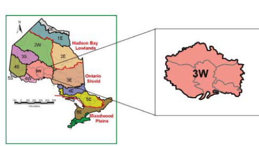
This ecoregion encompasses 8,883,560 ha (9.0% of the province) and includes Lake Nipigon. It extends west almost to Thunder Bay, north to the Agutua-Windigo Moraine, east to the Geraldton Plain, and south to the northern shore, peninsulas, and islands of Lake Superior.
Climate
The climate in this ecoregion is moist and cold, classified by the Ecoregions Working Group (1989) as the Moist Mid-Boreal Ecoclimatic Region. Annual precipitation ranges from 654 to 879 mm, and mean summer rainfall from 231 to 298 mm. Recent climate models indicate that the area of Ecoregion 3W is cooler than immediately adjacent areas of similar latitude and hence, exhibits a stronger boreal nature with lower mean annual temperatures (-1.7 to 2.1°C) and a shorter mean growing season length (161 to 182 days) (Mackey et al., 1996a, b; OMNR, 2000). The ecoregion exhibits a rapid increase in boreal climate influences in a northward direction as one moves away from the modifying effects of Lake Superior. However, both Lakes Nipigon and Superior provide modifying temperature and precipitation influences in the southern part of the ecoregion.
Geology and substrates
This ecoregion is situated on the Precambrian Shield. In addition to granitic bedrock, the Lake Nipigon Ecroregion contains substantial formations of basalt and other volcanic rocks, as well as greenstone, siltstone, and shale (Sutcliffe, 1991). Steep scarps, high mesas, and cuestas are evident throughout the southern portion and along Sibley and Black Bay Peninsulas, and cliffs are prominent along the Nipigon and Ottertooth rivers. The landscapes vary from strongly broken in the southern portion to weakly broken, more subdued topography in the north and west. Ground moraine is the prevalent surficial overburden, but there also are considerable glaciolacustrine and glaciofluvial deposits aligned with the orientation of the major morainal systems surrounding Lake Nipigon. The Nakina, Crescent, and Onaman end and interlobate moraines cross the central portion of the ecoregion, the Kaiashk Moraine extends westward from the shore of Lake Nipigon, and the major features of the Agutua-Windigo Moraine coincide with the northeastern boundary (Barnett et al.., 1991b; Zoltai, 1965a, b).
Substrates on well-drained, coarse-textured sites show brunisolic and podzolic development patterns. In areas of neutral to calcareous, fine-textured materials, luvisolic profiles dominate. Peats and Gleysols are found in poorly drained sites and bedrock depressions. Major substrate types characterizing this ecoregion include Humo-ferric Podzols (37%), Dystric Brunisols (26%), acidic rock outcrops (25%), and Mesisols (8%). Most of the substrates in the ecoregion have low to moderate buffering capacity, but a band of substrates with high capacity to reduce acidity from atmospheric deposition occurs along the north shore of Lake Nipigon (Environment Canada, 1988).
Land cover
The most frequent landcover type in the ecoregion is mixed forest (23.5%), followed by coniferous forest (23.0%), water (17.1%), sparse forest (15.1%), deciduous forest (9.0%), and cutovers (5.7%).
Deciduous forest fire cycles range between 70 and 210 years, and fires tend to be variable in intensity. Jack pine forest fire cycles are somewhat shorter, between 50 and 187 years, and fires tend to be stand replacing (van Sleeuwen, 2006). Growing season moisture deficits compounded by shallow substrates result in an intense fire regime characterized by relatively frequent and large fires.
Water
This well drained ecoregion is situated in the Great Lakes Watershed. The most prominent aquatic ecosystem is Lake Nipigon. The ecoregion is bounded on its south side by the north shore of Lake Superior, including Black Bay and Nipigon Bay. Rivers and lakes are numerous. Dog, Muskeg, Pakashkan, Caribou, Mojikit, Onaman, Esnagami, and Long Lakes exemplify the larger lakes found here. Rivers such as the Dog, Gull, Kopka, Blackwater, Nipigon, Black Sturgeon, Gravel, Steel, and Pic Rivers originate in, or flow through, the ecoregion.
Flora and fauna
Ecoregion 3W is contained mainly within two of Rowe’s (1972) forest sections, Nipigon and Superior, with small portions in the Central Plateau and Upper English River. All four forest sections are within the Boreal Forest Region. The vegetation in the ecoregion consists of black spruce, white spruce, balsam fir, trembling aspen, white birch, and jack pine on upland sites. White spruce and balsam fir are particularly well represented on the fine-textured substrates around Lake Nipigon. Large areas of pure jack pine and jack pine-black spruce conifer stands dominate on the sandy materials in the western portion of the ecoregion around Ignace, Graham, and Raith. Black spruce and tamarack predominate in conifer swamps and peatlands (fens and bogs) in low-lying areas. Great Lakes-St. Lawrence forest species such as eastern white pine and red pine occur in pockets on warmer-than-normal sites in the more southerly portions and arctic/alpine plants occur on colder-than-normal sites on the shores of Lake Superior.
Black ash, American elm, and balsam poplar occur along with other species with southern affinities on richer, finer-textured materials associated with river valleys (Noble, 1979a).
Characteristic fauna include moose, American black bear, snowshoe hare, bald eagle, common raven, hermit thrush, black-throated green warbler, yellow-rumped warbler, white-throated sparrow, blue-spotted salamander, eastern red-backed salamander, spring peeper, northern leopard frog, western painted turtle, and northern red-bellied snake. In aquatic ecosystems, shortjaw cisco, lake whitefish, fathead minnow, burbot, brook stickleback, yellow perch, lake trout, brook trout, and mottled sculpin are found.
Land use
The major communities within this ecoregion include Nipigon, Armstrong, Geraldton, Longlac, Schreiber, and Terrace Bay. Although forestry is the primary industry, resource-based tourism is also important. Hunting, trapping, fishing, and mineral exploration also are significant activities.
Fourteen types of natural heritage areas are located in Ecoregion 3W, including Wabakimi Provincial Wilderness Class Park, Lake Superior National Marine Conservation Area, Lake Nipigon Conservation Reserve, and the Gull Bay Enhanced Management Area.
Ecoregion boundary delineation and rationale
The northern boundary with Ecoregion 2W coincides with temperature and precipitation gradients and associated changes in estimated net primary productivity. Its boundary with Ecoregion 4S is strongly associated with mean January precipitation. The southwestern boundary with Ecoregion 4W is strongly correlated with numerous climatic variables (including mean annual temperature and growing season length) and with geological differences. Its eastern boundary also is related to climatic variables (Baldwin et al., 1998).
Ecoregion 4E (Lake Temagami Ecoregion)
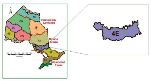
The Lake Temagami Ecoregion is situated between Lake Superior and the Quebec border, south of Wawa, the Chapleau Moraine, and the Donneganna Sand Plain, and north of the Montreal River at its western end, cutting south to include Ranger Lake, and eastward north of Elliot Lake, Sudbury, and Marten River, to include the Little Clay Belt and Temagami. It encompasses 4,057,806 ha or 4.1% of the province’s area.
Climate
The climate in this ecoregion is humid and cool. It has been classified by the Ecoregions Working Group (1989) as the Humid Low Boreal Ecoclimatic Region. Mean annual precipitation in the ecoregion ranges between 725 and 1,148 mm per year and the mean summer rainfall is between 217 and 291 mm. The mean annual temperature ranges from 0.8 to 4.3°C and the mean growing season length is 171 to 200 days (Ecoregions Working Group, 1989; Hills, 1959; Mackey et al.., 1996a, b).
Geology and substrates
This ecoregion is situated on the Precambrian Shield where the bedrock is predominantly granitic and gneissic. Ground moraine is the main surficial feature, although there are numerous north-south-flowing river systems in which valley train deposits are found, and localized areas with end moraines, aeolian deposits, lacustrine deposits, and eskers. Much of the terrain is moderately to strongly broken, although there are some weakly broken areas as well. Upland sites on glaciofluvial sands and on tills tend to have weakly developed Podzols and Brunisols, whereas peats and Gleysols develop on poorly drained sites. Over half of the ecoregion is characterized as having thinly covered acidic bedrock (61%), with very poor substrate development. Of the better developed substrates, 27% of the ecoregion is covered in Humo-ferric Podzols, 7% in Mesisols, 4% in Gleysols, and 1% in Dystric Brunisols.
The Little Clay Belt is situated at the eastern edge of this ecoregion. It differs from the rest of the ecoregion because it is underlain with Paleozoic limestone and related rocks, and as a result, has richer calcareous substrates. These generally are Gray Brown Luvisols on well drained sites, and peats and Gleysols on wetter, poorly drained sites.
Most of the ecoregion is underlain by Precambrian rocks, and the overburden is derived mainly from acidic parent materials, as a result the substrates tend to have a low buffering capacity for acidic deposition, except in the Little Clay Belt (Environment Canada, 1988).
Land cover
Mixed forest (33.2%), coniferous forest (19.9%), and deciduous forest (17.1%) are the dominant land cover types in this ecoregion. Water (10.9%), sparse forest (5.6%), and cutovers (3.6%) are scattered throughout. Agricultural lands are concentrated in the Little Clay Belt.
The fire cycle in mixed forests in the ecoregion ranges between 70 and 210 years. The cycle is shorter in forests with a higher percentage of coniferous trees. The fire cycle in jack pine systems ranges from 50 to 187 years, and fires tend to be stand replacing. In eastern white pine-red pine-jack pine ecosystems, the fire cycle ranges between 36 and 258 years, with fires burning at variable intensities. Tolerant hardwood fire cycles are much longer, ranging between 300 and 2,700 years. Lowland forests have even longer fire cycles, ranging between 150 and 6,000 years (van Sleeuwen, 2006). Fire plays an important role in forest regeneration, particularly for the pine species. Historically, fire was a more influential force but suppression has changed ecosystem dynamics. There was a substantial decrease in the number of large fires in this ecoregion during the 20th century.
Water
The Lake Temagami Ecoregion is a land of numerous lakes and rivers. The area is well to rapidly drained. Its northern boundary lies just south of the divide between the Hudson Bay and Great Lakes Watersheds, so all of its rivers ultimately drain southward to Lakes Superior and Huron and to the Ottawa/St. Lawrence Rivers. Some of the major river systems that flow from or through the ecoregion include the Montreal (two of them, one in the west and one in the east), Batchawana, Goulais, Garden, Mississagi, Spanish, Sturgeon, Blanche, and Ottawa Rivers. Water control structures have altered the hydrology of many of these rivers. In addition to numerous natural or near-natural lakes, such as Lake Timiskaming, Lake Temagami, Lady Evelyn Lake, and Wanapitei Lake, several large artificial reservoirs are found in the ecoregion, including Rocky Island, Bark, and Biscotasi Lakes.
Flora and fauna
Ecoregion 4E is situated primarily within the Great Lakes–St. Lawrence Forest Region, and a small portion is located in the Boreal Forest Region (Rowe, 1972). Three forest sections, Algoma, Timagami, and Haileybury Clay comprise the Great Lakes-St. Lawrence portion, while the Boreal portion is contained within the Missinaibi-Cabonga Section (Rowe, 1972). This ecoregion is covered in transitional forests that combine elements of the Great Lakes-St. Lawrence Forest Region to the south and the Boreal Forest Region to the north (Maycock, 1979; Rowe, 1972; Taylor et al., 2000). It contains the hardiest of the Great Lakes-St. Lawrence forest species, such as eastern white pine, red pine, sugar maple, red maple, and yellow birch. It also contains significant concentrations of boreal species on certain landform units, particularly jack pine and black spruce. Tolerant and semi-tolerant hardwoods such as sugar maple, red maple, and yellow birch tend to occur on warmer-than-normal sites (Taylor et al., 2000). Arctic/alpine relict plants occur along basaltic portions of the Lake Superior shoreline.
Characteristic fauna of this ecoregion include moose, beaver, American marten, American black bear, American black duck, broad-winged hawk, barred owl, winter wren, hermit thrush, black-throated green warbler, white-throated sparrow, eastern red-backed salamander, spring peeper, northern leopard frog, mink frog, snapping turtle, eastern gartersnake, and northern ring-necked snake. Aquatic ecosystems provide habitat for lake trout, brook trout, lake whitefish, northern pike, emerald shiner, longnose sucker, creek chub, rock bass, pumpkinseed, and many other fish species.
Land use
The major communities within this ecoregion include Temagami, New Liskeard, Earlton, Haileybury, and Cobalt. Although commercial forestry is the predominant land use activity in the ecoregion, agriculture is important in the Little Clay Belt. Wilderness and other forms of outdoor recreation, including canoe tripping, hunting, trapping, and fishing, along with supporting services, also are important activities in the ecoregion.
Currently 14 types of natural heritage areas are located in Ecoregion 4E, including Lake Superior Provincial Natural Environment Class Park, Lady Evelyn Smoothwater Provincial Wilderness Class Park, Ranger North Conservation Reserve, and areas managed by the Nickel District Conservation Authority.
Ecoregion boundary delineation and rationale
The northern boundary with Ecoregion 3E is based on climatic variables (i.e., mean July precipitation, growing season length, and mean annual temperature) and correlates strongly in some sections with major moraines and sand plains. The northern boundary also coincides roughly with the Hudson Bay Watershed.
Its southern boundary is strongly correlated with climatic variables (i.e., mean annual precipitation, mean annual temperature, and mean January temperature) and with elevation and geological differences (Baldwin et al., 1998). The boundary between Ecoregions 4E and 5E approximates the mean annual length of the growing season of about 175 days, and mean annual growing degree-days of about 2,600 (Chapman and Thomas, 1968).
Ecoregion 4S (Lake Wabigoon Ecoregion)
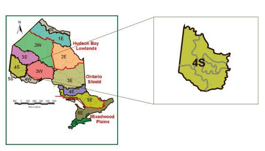
The Lake Wabigoon Ecoregion extends from the northern portion of Lake of the Woods north to Red Lake, and east to Lac Seul, Sioux Lookout, Dryden, and Rainy Lake. This ecosystem encompasses 5,958,799 ha (6.0% of the province).
Climate
The climate is relatively dry and cool. It is within the Subhumid Transitional Low Boreal Ecoclimatic Region (Ecoregions Working Group, 1989). This ecoregion is significantly influenced by the adjacent prairie climate, and seasonal weather patterns can include substantial periods of summer drought. The mean annual temperature ranges between 0.1˚ and 2.6˚C, the mean length of the growing season is 174 to 188 days, the mean annual precipitation is between 565 and 724 mm, and the mean summer rainfall is 245 to 291 mm (Mackey et al., 1996a, b).
Geology and substrates
The Lake Wabigoon Ecoregion is comprised mainly of gneissic, granitic, and metavolcanic Precambrian bedrock (Beakhouse, 1991; Breaks, 1991). Substantial areas, especially in the west, are characterized by bedrock exposures with limited unconsolidated matter. In the east, ground moraine of varying depths, as well as lacustrine deposits associated with the extensive post-glacial Lake Agassiz, occur. A large clay plain exists near Dryden (Hills and Morwick, 1944), and localized pockets of clay and silt are scattered in low-lying areas throughout the ecoregion. These lacustrine deposits form weakly broken terrain, while much of the rest of the ecoregion has moderately broken landscapes (Barnett et al.., 1991b; Zoltai, 1961, 1965a, 1965b, 1974).
Moderately well developed luvisolic substrates develop on neutral and calcareous clay or silt materials on glaciolacustrine deposits (8% of the ecoregion). On the coarser upland materials, associated with very low base morainal and glaciofluvial deposits, it is most common to find Dystric Brunisols (51%). Gleysolic substrates (1%) develop in all low-lying areas, and Mesisols (10%) predominate on wet, acidic sites. Acidic exposed rock occupies 29% of the area. The ecoregion’s bedrock and substrates have low to moderate capacity to buffer acidity (Environment Canada, 1988).
Land cover
Forests (65.3%) dominate the landscape; mixed forest occupies 25.2%, sparse forest occupies 23.8%, coniferous forest covers 14.3%, and deciduous forest covers 2.0% of this ecosystem. Water covers 24% and cutovers are located on 4.9% of the ecoregion.
There is a sizable area of bare and sparsely vegetated bedrock-dominated terrain in the western part of this ecoregion, where an intense fire regime, dry climate, and shallow substrate limit forest productivity. Upland coniferous forest fire cycles range between 50 and 187 years, and fires in these ecosystems tend to be stand replacing. Mixed forest fire cycles tend to be longer, between 63 and 210 years, and fire intensity is more variable (van Sleeuwen, 2006). Large fires have been common in the recent past, with the 1980s being a notable example.
Substantial areas of land with fertile clay and silt substrates were cleared for agriculture near Dryden, Kenora, and Fort Frances during the 20th century. While some pasture and mixed-livestock farming is practiced today, much of the cleared land has been abandoned and is reverting to early successional aspen and mixed-coniferous woodlands.
Water
Many lakes have formed in this ecoregion, including Lac Seul, Lake of the Woods (northern portion is in this ecoregion), Rainy, Umfreville, Eagle, Shoal, Minnitaki, and Wabigoon Lakes. The ecoregion is generally well drained by the Nelson Watershed westward into Manitoba and then northward via the Nelson River to Hudson Bay. River systems found include the English, Wabigoon, and Winnipeg Rivers.
Flora and fauna
In Rowe’s (1972) forest region classification, southern portions of Ecoregion 4S are located in the Quetico Forest Section within the Great Lakes-St. Lawrence Forest Region. Consistent with climatic trends, the northern portions of the ecoregion are contained within the Upper English River and Lower English River Forest Sections of the Boreal Forest Region. The vegetation in this ecoregion shows a strong boreal affinity, with jack pine, black spruce, balsam fir, trembling aspen, white birch, and some white spruce on upland sites. Black spruce and tamarack predominate in lowland habitats, with black ash and balsam poplar being the most common hardwood associates. It is important to note that the vegetation communities in this ecoregion reflect a steep climatic gradient and exemplify a zone of rapid ecological transition. On warmer and drier sites in much of the central and southern portions of the ecoregion, species such as American elm, ironwood, bur oak, large-tooth aspen, eastern white pine, and red pine are relatively abundant. Red maple, sugar maple, and American basswood are scattered in the southern part of the ecoregion and demonstrate a similarity to the adjacent western portions of the Great Lakes-St. Lawrence Forest Region extending from southern Lake of the Woods (Ecoregion 5S) into Minnesota and Wisconsin (MNDNR, 2003; Noble, 1978, 1979b; Sims et al., 1997). Some species with prairie affinities, such as bur oak, nodding onion, and big bluestem grow in the drier woodland habitats in the western part of Ecoregion 4S (Maycock, 1979).
Characteristic terrestrial fauna in the ecoregion include gray wolf, ermine, fisher, American mink, moose, snowshoe hare, bald eagle, merlin, ruffed grouse, gray jay, common raven, hermit thrush, yellow-rumped warbler, blue-spotted salamander, boreal chorus frog, green frog, western painted turtle, and red-sided gartersnake. In addition to widespread fish species such as lake trout, northern pike, and northern redbelly dace, species with more southern or western affinities, such as goldeye, muskellunge, pumpkinseed, and river darter inhabit rivers and lakes.
Land use
Dryden, Kenora, and Fort Frances are the largest communities in the ecoregion. Although forestry dominates the economy, resource-based tourism, including hunting and fishing, also are important. Agriculture is practiced in the Dryden and Fort Frances areas, which are overlain with clay and silty substrates.
Currently, 12 types of natural heritage areas are located in Ecoregion 4S, including Woodland Caribou Provincial Wilderness Class Park, Bloodvein Canadian Heritage River, Adair Lake Conservation Reserve, and Rice Lake Provincially Significant Wetland.
Ecoregion boundary delineation and rationale
There has been considerable variation in the way in which this ecoregion has been delineated in previous classifications, particularly along its southern boundary, because of the rapid climatic and geological transitions that occur there (Band et al.., 1999; Wickware and Rubec, 1989). Burger (1993) suggested that it should encompass all of Hills’ (1961) Site Region 5S. Here, Ecoregion 4S incorporates Hills’ Site District 5S-1 around the northern part of Lake of the Woods, including its rugged, rock-dominated landscapes, but excludes the geologically and climatically distinct Lake Agassiz clay plain, which extends from the southern end of Lake of the Woods to Fort Frances. This clay plain is retained as Ecoregion 5S.
The boundary between Ecoregions 4S and 3S is strongly correlated with elevation and geological differences, and is also supported by precipitation and temperature variables. The northeastern boundary with Ecoregion 3W is based on January mean monthly precipitation. The southeastern boundary with Ecoregion 4W is supported by climatic variables, and the southwestern boundary with Ecoregion 5S correlates with climatic variables, elevation, and surficial geological differences (Baldwin et al., 1998).
Ecoregion 4W (Pigeon River Ecoregion)
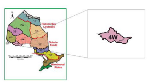
This ecoregion extends from just west of the Sibley Peninsula and Thunder Bay west to Atikokan and Quetico Provincial Park. It covers 2,035,903 ha (2.0% of the province).
Climate
The climate of this ecoregion is cool and relatively dry. It is within the Moist Low Boreal Ecoclimatic Region (Ecoregions Working Group, 1989). Annual precipitation ranges between 674 to 838 mm and the mean summer rainfall ranges from 225 to 300 mm. The eastern portion of the ecoregion is affected by Lake Superior climatic conditions. The mean annual temperature of Ecoregion 4W is 0.2 to 2.7°C and the mean growing season length is 168 to 188 days (Mackey et al.., 1996a, b; OMNR, 2000).
Geology and substrates
This ecoregion is located on the Precambrian Shield. Bedrock types are dominated by very low-base granites, with bands of base-rich, ultramafic and greenstone minerals. The terrain is irregular and, in places, quite rugged in the central and northern portions of the ecoregion (Mackey et al., 1994). There are numerous rock-rimmed lakes. The southeastern part of the ecoregion contains several massive, steep-walled, sloping cuestas locally known as the ‘Nor’westers’. At the eastern end of the ecoregion, bedrock conglomerates and slates have been covered with glaciolacustrine clays and sands (Williams, 1991; Williams et al.., 1991). The Precambrian bedrock in the remainder of the ecoregion generally is overlain with thin, coarse ground moraine (till). In the central and western portions, glaciolacustrine deposits are discontinuous and mixed with glaciofluvial deposits (Zoltai, 1961, 1963).
Dystric Brunisols (52%) and Gray Luvisols (2%) blanket well-drained sites, and Mesisols (11%) and Gleysols (2%) cover poorly drained sites. Exposed bedrock is extensive and covers 32% of the ecoregion. Of note are the distinctive red, iron-bearing clays in the eastern portion of the ecoregion which have moderate lime content (Hills and Morwick, 1944). Elsewhere in the ecoregion, the substrates and bedrock generally have low capacity to buffer acidity from atmospheric deposition (Environment Canada, 1988).
Land cover
Mixed forest is the most extensive landcover class (33.2%) in this ecoregion. Sparse forest occurs on 19.3%, water occurs on 17.5%, coniferous forest occurs on 11.5%, deciduous forest occurs on 10.6%, and cutovers occupy 3.6% of the area.
Deciduous forest fire cycles range between 70 and 210 years, and fire intensity in such ecosystems is variable. Mixed forest fire cycles tend to be shorter, because of the coniferous component, ranging between 63 and 210 years (van Sleeuwen, 2006).
Water
Numerous rock-rimmed lakes are characteristic of the landscape, especially in central and western locations. Some of these include Loch Lomond, Lac la Croix, Whitefish, Northern Light, Saganaga, Agnes, Basswood, Pickerel, Quetico, Namakan, and Marmion Lakes. Most of the ecoregion drains through the Nelson Watershed along a complex system of minor waterways that eventually connect to the Seine River in the west. The Pigeon River is one of the few major rivers in the ecoregion and flows eastward along the Ontario-Minnesota border through the Great Lakes Watershed to Lake Superior. The ecoregion is well drained.
Flora and fauna
The Pigeon River Ecoregion is located in the Quetico Section of Rowe’s (1972) Great Lakes-St. Lawrence Forest Region. Vegetation communities are comprised of a mixture of boreal and Great Lakes-St. Lawrence species. Eastern white pine, white spruce, jack pine, and red pine grow on well-drained sites. Pure or mixed stands of jack pine, trembling aspen, large-tooth aspen, white birch, balsam fir, white spruce, and/or black spruce frequent areas where fires or logging have occurred (Rowe, 1972). Sugar maple, yellow birch, American basswood, ironwood, box elder, and bur oak inhabit some warmer-than-normal sites, particularly in the southeastern and southwestern part of the ecoregion. Lowland habitats contain black spruce, white spruce, balsam fir, tamarack, and eastern white cedar, with lesser amounts of black ash, American elm, and red maple (Maycock, 1979; Noble, 1980).
Characteristic mammals, birds, amphibians and reptiles in the ecoregion include moose, American black bear, snowshoe hare, hooded merganser, ruffed grouse, pileated woodpecker, hermit thrush, magnolia warbler, white-throated sparrow, central newt, spotted salamander, gray treefrog, western painted turtle, and northern red-bellied snake. Lake trout, lake chub, northern pike, burbot, golden shiner, bluntnose minnow, and rock bass, and many other species inhabit rivers and lakes.
Land use
Predominant land uses in the ecoregion include forestry, resource-based tourism, and agriculture. Thunder Bay is a large urban area with manufacturing (e.g., railcars), transportation services (e.g., grain handling), and government.
Currently, 4W encompasses 12 types of natural heritage areas, including Quetico Provincial Wilderness Class Park, Matawin River Provincial Nature Reserve Class Park, Scenic Lake Conservation Reserve, and the Shoal Lake Wilderness Area.
Ecoregion boundary delineation and rationale
The boundary between Ecoregions 4W and 3W is strongly correlated with temperature variables and geological differences. The western boundary with Ecoregion 4S is based on precipitation and temperature variables (Baldwin et al., 1998). Generally, Ecoregion 4W has a distinctly more humid climate compared to the adjacent Ecoregion 4S to the west, and a warmer climate than Ecoregion 3W to the north.
This ecoregion is contiguous and coincident with the Northern Superior Uplands Section in Minnesota’s classification system (Hanson and Hargrave, 1996).
Ecoregion 5E (Georgian Bay Ecoregion)
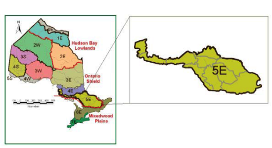
The Georgian Bay Ecoregion is situated on the southern portion of the Precambrian Shield, in south-central Ontario, extending from southeastern Lake Superior in the west to the central portion of the Ottawa River valley and the Quebec border in the east. It encompasses 7,447,869 ha (7.5% of the province).
Climate
The climate of the Georgian Bay Ecoregion is cool-temperate and humid. It is within the Humid High Moderate Temperature Ecoclimate Region (Ecoregions Working Group, 1989). The mean annual temperature range is 2.8 to 6.2˚C, and the mean length of the growing season is between 183 to 219 days (Mackey et al., 1996a, b). Mean annual precipitation ranges between 771 and 1,134 mm, and the mean summer rainfall is between 204 and 304 mm (Mackey et al., 1996a, b).
Geology and substrates
This ecoregion is situated on the southern edge of the Precambrian Shield, with the underlying bedrock being comprised predominantly of migmatitic gneisses and felsic igneous rocks, but with some substantial areas of felsic plutonic, carbonate metasedimentary, and mafic rocks, and lesser amounts of various other types of bedrock (Bennett et al.., 1991; Easton, 1992). The Sudbury Basin is composed of volcanic ultramafic rocks. Marble outcrops are scattered throughout the southeastern portion of the ecoregion. The surficial geology of the ecoregion reflects its bedrock control. Other surficial materials and landforms are highly variable. Much of the bedrock is covered with ground moraine (till) of variable depth, however glaciofluvial materials associated with spillways and outwash deposits can also be found. Aeolian deposits are rare. The terrain in the ecoregion varies considerably from weakly broken to strongly broken. There are several upland areas, including the Algonquin Dome, the Haliburton Highlands, and the Madawaska Highlands.
Substrates in the Georgian Bay Ecoregion, include Humo-ferric Podzols (59%), acidic bedrock (26%), Mesisols (6%), and Melanic Brunisols (4%). Three quarters of the substrates in the ecoregion demonstrate low capacity to buffer the impacts of acidic precipitation (Environment Canada, 1988).
Land cover
The land cover in this ecoregion is dominated by mixed forest (32.0%), deciduous forest (22.2%), coniferous forest (12.1%), and sparse forest (11.3%). A small percentage is classified as cutover or burn, because of the partial cutting systems that are used here, although the sparse forest class may account for some of the cutover area. Water and land classified as pasture comprise 11.0% and 3.0% of the area, respectively.
The fire cycle in the mixed forests in the ecoregion ranges between 70 and 210 years, the cycle being shorter with higher coniferous content. In jack pine systems, the fire cycle ranges from 50 to 187 years, and fires tend to be stand replacing. In eastern white pine-red pine-jack pine ecosystems, the fire cycle ranges between 36 and 258 years. Tolerant hardwood fire cycles are much longer, ranging between 300 and 2,700 years. Lowland forests have even longer fire cycles, ranging between 150 and 6,000 years (van Sleeuwen, 2006).
Water
The Georgian Bay Ecoregion is situated within the Great Lakes Watershed. This rapidly drained area contains portions of numerous river systems, including the Montreal, Batchawana, Goulais, Mississagi, Spanish, Ottawa, French, Mattawa, Petawawa, Madawaska, York, Nipissing, Magnetawan, Muskoka, and Severn Rivers. Several of these rivers have their source in this ecoregion. Lakes are prominent and characteristic features in most parts of the ecoregion, including large lakes like Nipissing, Muskoka, Joseph, Rosseau, Opeongo, Lake of Bays, Round, Golden, and Centennial.
Flora and fauna
This ecoregion is situated in the heart of the Great Lakes-St. Lawrence Forest Region, comprising some or all of the Algoma, Sudbury-North Bay, Algonquin-Pontiac, Georgian Bay, and Middle Ottawa Forest Sections (Rowe, 1972). It is characterized by a mixture of elements from both the south and the north, but Great Lakes–St. Lawrence forest species such as eastern white pine, red pine, eastern hemlock, and yellow birch are frequent throughout. In the past, red spruce was a much more prominent component of forests in this ecoregion, occupying similar sites to those occupied by eastern hemlock, but it has been eliminated as a major element of forest ecosystems here, due to poor silviculture (Gordon, 1994). On mesic to dry mesic sites, sugar maple is a dominant species, and other hardwoods such as American beech, wild black cherry, American basswood, and white ash may be common as well, especially in the southern part of the ecoregion. Boreal species such as black spruce, white spruce, balsam fir, jack pine, and tamarack are more localized and grow either on cooler-than-normal sites or where substrate conditions favour their growth over that of the Great Lakes-St. Lawrence species (Hills, 1959; Rowe, 1972). Balsam fir often is found in the understories, or as a lesser component in the canopies, of many forest stands (Hills, 1959).
Representative fauna include little brown bat, American black bear, moose, fisher, North American river otter, beaver, common loon, osprey, broad-winged hawk, ruby-throated hummingbird, pileated woodpecker, yellow-bellied sapsucker, winter wren, veery, Blackburnian warbler, black-throated blue warbler, yellow-rumped warbler, scarlet tanager, rose-breasted grosbeak, red-spotted newt, northern two-lined salamander, four-toed salamander, gray treefrog, pickerel frog, American bullfrog, snapping turtle, smooth greensnake, and northern ring-necked snake. In the numerous lakes and rivers, fish such as lake trout, brook trout, lake whitefish, yellow perch, walleye, bluegill, rock bass, brown bullhead, bluntnose minnow, northern redbelly dace, and golden shiner are found.
Land use
The larger communities in the ecoregion include Sault Ste. Marie, Blind River, Sudbury, North Bay, Mattawa, Parry Sound, Huntsville, Bracebridge, Gravenhurst, Deep River, Elliot Lake, Minden, Bancroft, and Barry’s Bay. Cottages have been constructed on the shoreline of many rivers and lakes in Ecoregion 5E. Commercial forestry and associated processing are important economic activities along with mining and tourism (OMNR, 1997). Sudbury is the major mining centre within the ecoregion.
Twenty-six types of natural heritage areas are located in Ecoregion 5E, including the Rideau Canal World Heritage Site, Algonquin Provincial Natural Environment Class Park, Nipissing Crown Game Preserve, and H.N. Crossley (Ontario Nature) Nature Reserve.
Ecoregion boundary delineation and rationale
The southern boundary of this ecoregion is defined by the interface between the bedrocks of the Precambrian shield (“bare rock ridges and shallow till to the south” and “shallow till and bare rock ridges”) and the Ordovician limestones and dolostones (Chapman and Putnam, 1972). In the area of the Frontenac Axis, where the Precambrian shield extends southward into a more moderate macroclimatic zone, the boundary of Ecoregion 5E has been delimited to account for the change in frequency of exposed bare rock ridges in relation to the surrounding clay plains (i.e., the “Leeds knobs and flats”), as well as to partition the predominantly gneissic bedrocks from the highly complex intermingling of Precambrian gneisses with Ordovician sandstones, dolostones, and other younger sedimentary rocks. In addition to the climatic and geological correlations with this boundary, there are concomitant floristic and faunistic correlations. Its northern boundary with Ecoregion 4E is strongly correlated with climatic variables, elevation, and geological differences (Baldwin et al.., 1998).
Ecoregion 5S (Agassiz Clay Plain Ecoregion)
The Ontario portion of the Agassiz Clay Plain Ecoregion is bounded by Manitoba in the west, Minnesota in the south, the southern shore of Lake of the Woods on the north, and Fort Frances in the east. It covers 342,520 ha or 0.3% of the province and constitutes part of an extensive clay deposit associated with post-glacial Lake Agassiz that extends into Manitoba and Minnesota.
Climate
The climate in this ecoregion is cool-temperate and dry. It is within the Subhumid Transitional Low Boreal Ecoclimatic Region (Ecoregions Working Group, 1989). It is characterized by warm, moist summers and cold winters, where the mean annual temperature is 1.4 to 2.8°C, the mean length of the growing season is approximately 182 to 190 days, the mean annual precipitation is 559 to 660 mm, and the mean summer rainfall is between 243 and 287 mm (Ecological Stratification Working Group 1996; Mackey et al., 1996a, b; Wickware and Rubec, 1989).
Geology and substrates
The area is underlain by Precambrian gneissic and metavolcanic bedrock. In addition, there are morainal deposits and relatively deep glaciolacustrine deposits of calcareous clay and silt over the bedrock resulting from deeper inundations of post-glacial Lake Agassiz in most parts of the ecoregion. Lacustrine and aeolian sands occur along the shores of Lake of the Woods. Overall, the topography of the Ontario portion of the ecoregion is very weakly broken and undulating.
Substrates generally are Gleysols, common in moist calcareous materials, Gray Luvisols with some evidence of Chernozemic development (indicative of prairie vegetation and climatic influences), and deep peats that have developed on less basic sites. Gleysols cover 38%, Gray Luvisols cover 28%, Mesisols cover 21%, and bedrock covers 11% of the ecoregion. Because of the calcareous clay deposits, most of the substrates in the ecoregion have high buffering capacity against acidity from atmospheric deposition (Environment Canada, 1988).
Land cover
Sparse forest (22.7%), deciduous forest (13.6%), mixed forest (12.8%), and coniferous forest (8.5%) grow in 57.6% of the ecoregion. Pasture (16.8%), part of Lake of the Woods, and a few major river segments (particularly Rainy River) (13.6%) are important land cover types as well.
Deciduous forest fire return intervals range between 70 and 210 years, and fires in such ecosystems are variable in intensity. Mixed forest fire cycles tend to be somewhat shorter, ranging between 63 and 210 years (van Sleeuwen, 2006).
Water
The Agassiz Clay Plain Ecoregion is a relatively wet ecosystem because its substrates are predominately clays and silts, with high water-holding capacity, and the landscape is relatively flat and poorly drained. The western portion of the ecoregion is dominated by Lake of the Woods. Rainy River flows along the southern and southwestern edges of the Ontario portion of the ecoregion. Aside from these open water bodies, most of the water is located in peatlands and swamps. The entire ecoregion is located within the Nelson Watershed.
Flora and fauna
This ecoregion comprises the Rainy River Forest Section in the Great Lakes-St. Lawrence Forest Region in Rowe’s (1972) system. The juxtaposition of Great Lakes-St. Lawrence, boreal, and prairie ecosystems results in distinctive and diverse vegetation communities. Great Lakes-St. Lawrence Forest tree species are uncommon but present, and some of these species, such as sugar maple, red maple, wild black cherry, American basswood, and green ash, approach or reach their northern range limit here. Boreal species such as white spruce, balsam fir, trembling aspen, and white birch are frequent (Ecological Stratification Working Group, 1996; Rowe, 1992). On dry clays and rock outcrops, species such as bur oak, northern pin oak, and American elm, often with graminoid understories, form glades. Extensive wetlands with black spruce, tamarack, eastern white cedar, willow, and speckled alder have evolved in low lying, poorly drained sites.
The fauna also represents a mixture of southern, northern, and western species such as sharp-tailed grouse, black-billed magpie, western meadowlark, white-tailed jack rabbit, and Franklin’s ground squirrel intermingling with species of more southern and eastern affinities, such as golden-winged warbler, scarlet tanager, blue-spotted salamander, American toad, and northern red-bellied snake, and more northern species such as American black bear, snowshoe hare, Connecticut warbler, boreal chickadee, gray jay, and boreal chorus frog. Lake trout, lake whitefish, northern pike, muskellunge, rock bass, pumpkinseed, black crappie, bluntnose minnow, and blacknose dace are characteristic species inhabiting rivers and lakes.
Land use
Fort Frances and Rainy River are the largest towns in the ecoregion, with smaller agricultural and resource-based towns such as Emo and Stratton situated between them. Forestry, agriculture, and resource-based tourism are the predominant land uses in the ecoregion.
There are six types of natural heritage areas in Ecoregion 5S, including the Blue Township Minerotrophic Peatlands International Biological Programme Site, Lake of the Woods Provincial Natural Environment Class Park, and the Agassiz Peatland Provincially Significant Wetland.
Ecoregion boundary delineation and rationale
The boundary of Ecoregion 5S with that of Ecoregion 4S to the north correlates with temperature variables, elevation, and surficial geology (Baldwin et al., 1998). It constitutes the northward extension into Ontario of the Agassiz Lowlands Subsection in Minnesota’s ELC (Hanson and Hargrave, 1996).
Mixedwood Plains Ecozone
This southern ecozone is situated on limestone and dolostone formations south of the Precambrian Shield. It encompasses 8,497,803 ha or 8.6% of the province. Ontario’s portion of the ecozone is bounded along its southern and western edges by Lakes Huron, Erie, and Ontario, and the St. Lawrence River. This ecozone extends into southern portions of Quebec along the St. Lawrence lowlands.
The climate of this ecozone is cool to mild in a continental context, with cool winters and relatively warm summers. It has one of the mildest climates in Canada. The mean daily temperatures in January range between -3 and -12°C and the mean daily temperatures in July range between 18 and 22°C. The Great Lakes provide a moderating influence. It is also a relatively moist ecozone, receiving between 720 and 1,000 mm of precipitation per year.
The bedrocks in this ecozone are primarily limestone, sandstone, and shale of Ordovician, Silurian, and Devonian ages, with outcrops of sandstone and shale. Surficial materials and landforms are varied, with moraines, lacustrine deposits, and glaciofluvial deposits predominating. Marine silt and clay deposits associated with the post-glacial Champlain Sea occur in the Ottawa and St. Lawrence River valleys.
Topographic variation is significant ranging from extremely flat terrain in the southwest and southeast to the rugged terrain of the Niagara Escarpment and numerous terminal and interlobate moraines. Substrates generally are well developed and fertile, and include Luvisols and Gleysols. Hydrology varies in relation to the surficial and bedrock features of the area, with rapid, high-gradient rivers flowing off the Escarpment, meandering slow rivers and streams in areas of low relief, and wetlands in depressions and in areas underlain by clay. Major river systems include the Grand, Humber, Credit and Thames Rivers.
The predominant type of natural disturbance in forest ecosystems is the creation of small gaps through individual trees falling down (known as gap-phase dynamics). However, major weather events (i.e., wind and ice storms) and insect outbreaks can cause more extensive forest disturbance. In wetland systems, beavers are a major force of change. In some of the more localized habitats, such as tall-grass prairies, oak savannahs, and perhaps alvars, fire is more important for habitat renewal.
Vegetation is diverse, despite the conversion of most forested land and wetlands to urban and suburban areas, road networks, and agriculture. Mixed deciduous-evergreen forests and tolerant hardwood forests (including those forests known as Carolinian forests) grow in this ecozone. Alvars and tall-grass prairies also occur here. Although many wetlands were drained during the 19th and 20th centuries, some wetland ecosystems remain. The fauna and flora are among the most diverse in Canada, and the number of species at risk is also high. Among the characteristic species in the ecozone are white-tailed deer, red fox, coyote, northern raccoon, striped skunk, beaver, eastern gray squirrel, great blue heron, red-tailed hawk, black-capped chickadee, blue jay, American robin, wood thrush, yellow warbler, Midland painted turtle, eastern red-backed salamander, smallmouth bass, walleye, yellow perch, pearl dace, and spottail shiner. Alien biota is increasingly problematic in this ecozone, because these species displace native species and alter structural and functional aspects of natural ecosystems.
This ecozone is the most densely populated area in Canada, and many of its natural ecosystems have been converted to human uses, for agriculture and infrastructure. Some of the major cities in this ecozone include Windsor, London, Hamilton, Toronto, Barrie, Oshawa, Kitchener-Waterloo, Peterborough, Kingston, and Ottawa.
Climate change will combine with other types of impacts such as habitat fragmentation and smog to affect ecosystem composition, structure, and function in southern Ontario (Chiotti et al., 2008). For example, climate model projections suggest that this ecozone will be more susceptible to drought in the 21st century, which will favour the establishment and survival of xeric (drought-loving) species (Chiotti et al., 2007).
Ecoregion 6E (Lake Simcoe-Rideau)
The Lake Simcoe-Rideau Ecoregion encompasses 6.4% (6,311,957 ha) of Ontario. It extends from Lake Huron in the west to the Ottawa River in the east, and includes most of the Lake Ontario shore and the Ontario portion of the St. Lawrence River Valley. It also includes Manitoulin, Cockburn, and St. Joseph’s Islands in Lake Huron.
Climate
The climate is mild and moist, classified in the Humid High Moderate Temperate Ecoclimatic Region (Ecoregions Working Group, 1989). The mean annual temperature range is 4.9 to 7.8°C, the mean length of the growing season is 205 to 230 days, the mean annual precipitation is 759 to 1,087 mm, and the mean summer rainfall is 198 to 281 mm (Mackey et al., 1996a, b).
Geology and substrates
The underlying bedrock is Paleozoic dolomite and limestone, mainly of Ordovician and Silurian ages, except for a complex zone of mixed bedrock types in the Frontenac Axis, where Precambrian (formed more than one billion years ago) granites and gneisses are mixed with Ordovician limestone and sandstone. The Frontenac Axis is an arch of rock between Algonquin Park and the Adirondacks (Chapman and Putnam, 1973).
The surface is gently undulating to rolling terrain of ice-laid materials deeply covering the bedrock, although in a few areas limestone plains with shallow substrates dominate. Deep ground moraine materials predominate with numerous areas showing well developed drumlins and end/interlobate moraine features such as the Oak Ridges, Wawanosh, Waterloo, and Saugeen Moraines. Local plains of smoother lacustrine deposits occur as well. The eastern portion of the ecoregion is underlain by glaciomarine deposits resulting from the brief post-glacial incursion of salt water from the Champlain Sea along the St. Lawrence valley. The Niagara Escarpment traverses the ecoregion and provides elevated rugged landscapes in the northern and central parts of this ecosystem. There are some rugged landscapes in the eastern portion as well, including the Frontenac Axis where numerous lakes and high hills provide picturesque vistas.
Mineral materials comprise more than 95% of the substrates, and are dominated by Gray Brown Luvisols (43%) and Melanic Brunisols (27%). Gleysols (14%) and Humo-ferric Podzols (5%) also are found. Most of the substrates provide a high capability to buffer the acidity of atmospheric deposition before it reaches surface waters (Environment Canada, 1988).
Land cover
More than 57% of the ecoregion exists as cropland (44.4%), and pasture and abandoned fields (12.8%). Forest cover includes deciduous (16.0%), coniferous (5.3%), and mixed forest (8.8%). Water covers 4% of the ecoregion.
Forest fire is not a significant natural force. Although fire regimes have been completely altered in the ecoregion due to fire suppression and land use change, pre-settlement fire regimes have been examined for a few ecosystems (van Sleeuwen, 2006). Deciduous forests had a fire cycle of 300 to 2,700 years, with variable fire intensity. Lowland forests had a cycle of 150 to 6,000 years. Intolerant hardwoods and mixed forests with a conifer component had fire cycles between 70 and 200 years. Some areas, for example rolling sandy plains, which originally supported prairie and savannah vegetation burned more frequently.
Water
The Ontario portion of the ecoregion is bounded by Lake Huron, Georgian Bay, Lake Ontario, the St. Lawrence River, and the Ottawa River. Other important rivers include the Grand River (a Canadian Heritage River), Rideau (a World Heritage Site), Trent, Nottawasaga, Humber, Saugeen, and Maitland Rivers. This ecoregion is located within the Great Lakes Watershed, and is generally well drained. Major inland lakes in the ecoregion include Lake Simcoe, the Kawartha Lakes, Lake Scugog, Rice Lake, and the Rideau lakes. Three major overburden aquifers (i.e., Kitchener, Alliston, and Oak Ridges) and three large bedrock aquifers (i.e., Detroit River, Guelph-Amabel, and Nepean) contain significant volumes of ground water (OMNR, 1984).
Flora and fauna
This ecoregion falls within Rowe’s (1972) Great Lakes-St. Lawrence Forest Region, including its Huron-Ontario and Upper St. Lawrence Sections, and a small part of the Middle Ottawa Forest Section. The vegetation is relatively diverse. Hardwood forests dominated by sugar maple, American beech, white ash, eastern hemlock, and numerous other species are found where substrates are well developed on upland sites. Lowlands, including rich floodplain forests, contain green ash, silver maple, red maple, eastern white cedar, yellow birch, balsam fir, and black ash. Peatlands (some quite large) occur along the northern edge and in the eastern portion of the ecoregion, and these contain fens, and rarely bogs, with black spruce and tamarack. Some of the best examples of North American alvar vegetation are located in the ecoregion.
Characteristic mammals include white-tailed deer, Northern raccoon, striped skunk, and woodchuck. Wetland habitats are used by many species of water birds and shorebirds, including wood duck, great blue heron, and Wilson’s snipe. Open upland habitats are used by species such as field sparrow, grasshopper sparrow, and eastern meadowlark. Upland forests support populations of species such as hairy woodpecker, wood thrush, scarlet tanager, and rose-breasted grosbeak. Reptiles and amphibians found in this ecosystem include American bullfrog, northern leopard frog, spring peeper, red-spotted newt, snapping turtle, eastern gartersnake, and common watersnake. Characteristic fish species in the ecoregion include the white sucker, smallmouth bass, walleye, northern pike, yellow perch, rainbow darter, emerald shiner, and pearl dace.
Land use
Ecoregion 6E is the second most densely populated ecoregion in Ontario, and encompasses a number of small to mid-size cities including Trenton, Belleville, Kingston, Cornwall, Peterborough, Ottawa, Barrie, Owen Sound, and Collingwood.
Twenty-seven types of natural heritage areas are located in Ecoregion 6E, including St. Lawrence Islands National Park, the Niagara Escarpment Biosphere Reserve, Frontenac Provincial Natural Environment Class Park, and the Oak Ridges Moraine.
Ecoregion boundary delineation and rationale
The northern boundary of this ecoregion coincides with the contact zone between Paleozoic and Precambrian bedrock, and is also correlated with precipitation and temperature variables. Its southern boundary is correlated with temperature, elevation, geological differences, and estimated net primary productivity (Baldwin et al., 1998).
Ecoregion 7E (Lake Erie-Lake Ontario)
This most southern ecoregion encompasses 2.2% (2,185,845 ha) of Ontario, and extends from Windsor and Sarnia east to the Niagara Peninsula and Toronto, with shoreline on Lakes Huron, Erie, and Ontario.
Climate
The climate in this ecoregion is one of the mildest in Canada. It has been classified in the Humid High Moderate Temperate Ecoclimatic Region (Ecoregions Working Group, 1989). The winters are cool and the summers are long, hot, and humid. The mean annual temperature range is 6.3 to 9.4°C, the mean length of the growing season is 217 to 243 days, the mean annual precipitation is 776 to 1,018 mm, and the mean summer rainfall is 196 to 257 mm (Ecoregions Working Group, 1989; Mackey et al.., 1996a, b).
Geology and substrates
Ecoregion 7E is underlain by Silurian and Devonian limestone bedrock. Except for the Niagara Escarpment from Burlington south to Queenston, and some morainal deposits and drumlin fields in the north-central part of the ecoregion, the topography is flat and overlain by deep undulating deposits of ground moraine. Most substrates in the ecoregion are comprised of calcareous mineral material with a minor component of the landscape composed of organic material. There are substantial glaciolacustrine deposits left over from historial lakes, including the Norfolk sand plain, the clay plain adjacent to Lake St. Clair, and the Haldimand clay plain.
The predominant substrates in the ecoregion include Gray Brown Luvisols (60%) and Gleysols (37%). These substrates provide high to moderate capability to buffer the acidity of atmospheric depositions before it reaches surface water (Environment Canada, 1988).
Land cover
About 78% of the ecoregion has been converted to cropland and pasture, and developed land (e.g., urban areas and road networks) encompasses more than 7% of the ecoregion. Of the remaining forest remnants, dense deciduous forest covers 10.3%, sparse deciduous forest covers 1.0%, and mixed deciduous forest covers 0.8% of the ecoregion. Forest fire is not a significant natural force. With the exception of some small fires in the 1960s, this ecosystem did not experience significant wildfire during the 20th century. However, in those areas where tall-grass prairie and oak savannahs once existed, fire was an important ecological force. Today, fire is used as a restoration tool in remnant prairie and savannah ecosystems.
Although fire regimes have been completely altered in the ecoregion due to fire suppression and land use change, pre-settlement fire regimes have been examined for a few ecosystems (van Sleeuwen, 2006). Deciduous forests had a fire cycle of 300 to 2,700 years, with variable fire intensity, and lowland forests had a cycle of 150 to 6,000 years. Intolerant hardwoods and mixed forests with a conifer component had fire cycles between 70 and 200 years. Forest fires are more frequent in areas which originally supported prairie and savannah vegetation.
Water
Ecoregion 7E is located in the Great Lakes Watershed. Several rivers have created incised valleys perpendicular to the shores of Lakes Huron, Erie, and Ontario, which add to topographic variation. The Grand, Thames, Detroit, and Humber Rivers, (all designated Canadian Heritage Rivers) are managed through activities of the Grand River Conservation Authority (CA), the Upper Thames River CA, the Essex Region CA, and the Toronto and Region CA. Other large rivers in the ecoregion include the Credit, Niagara, and Sydenham Rivers, and Big Creek. There are a few small lakes and drainage in this ecoregion is poor.
There are hundreds of small aquifers in sand and gravel deposits throughout this ecoregion. Although most wetlands have been eliminated, some coastal marshes, deciduous and coniferous swamps, and open fens remain scattered throughout the ecoregion. The Lake Erie coastal marshes (e.g., Point Pelee, Rondeau Bay, Long Point, and Turkey Point) support the largest diversity of flora and fauna in the Great Lakes (Ball et al., 2003).
Flora and fauna
Ecoregion 7E is contained within the Deciduous Forest Region, Niagara Forest Section (Rowe, 1972). The flora and fauna of this ecoregion are the most diverse in Canada. For example, remnants of Carolinian forests contain species such as the tulip-tree, black gum, sycamore, Kentucky coffee-tree, pawpaw, various oaks and hickories, and common hackberry, in addition to the more widespread sugar maple, American beech, white ash, eastern hemlock, and eastern white pine. This ecoregion also supports the largest remnants of tall-grass prairie in the province.
Typical mammals inhabiting this ecoregion include white-tailed deer, northern raccoon, striped skunk, and the Virginia opossum which has increased its distribution and abundance since the latter half of the 20th century. Characteristic birds include green heron, Virginia rail, Cooper’s hawk, eastern kingbird, willow flycatcher, brown thrasher, yellow warbler, common yellowthroat, northern cardinal, and savannah sparrow. Wild turkey has been re-introduced into the ecoregion. Herpetofauna, is diverse, including several provincially rare species (e.g., spiny softshell turtle), as well as more frequent species such as eastern red-backed salamander, American toad, eastern gartersnake, and Midland painted turtle. Longnose gar, channel catfish, smallmouth bass, yellow perch, walleye, northern hogsucker, banded killifish, and spottail shiner are among the fish species found in the lakes and rivers in this ecoregion.
This ecoregion is the most imperiled in Canada because of the amount of natural habitat that has been drained, cut, and converted into agricultural and suburban land uses. Many of Ontario’s species at risk occur here, including Acadian flycatcher, king rail, prothonotary warbler, hooded warbler, spiny softshell turtle, blue racer, and small-mouthed salamander.
Land use
This is the most heavily urbanized and industrialized ecoregion in Ontario. A number of the province’s largest cities are located here, including Toronto, Hamilton, Burlington, St. Catharines, Niagara Falls, Kitchener-Waterloo, London, and Windsor. Principal occupations include sales, finance, management, trades, manufacturing, social services, and agriculture.
Currently, 22 types of natural heritage areas are located in Ecoregion 7E, including the Long Point Peninsula Important Bird Area, Point Pelee National Park, The Pinery Provincial Natural Environment Class Park, and The Greenbelt.
Ecoregional boundary delineation and rationale
Due to its biological diversity, numerous studies have been conducted to try to accurately delineate the boundaries of Ecoregion 7E, using climatic features as well as species distribution patterns (e.g., Fox and Soper, 1952, 1953, 1954; Soper, 1956, 1962; Thaler and Plowright, 1973).
The boundary of Ecoregion 7E with Ecoregion 6E is based on climatic variables, elevation, surficial geological differences, and estimated net primary productivity (Baldwin et al., 1998). These features, and particularly climate features, also coincide with biotic differences, as described by Fox and Soper (1952, 1953, 1954), Soper (1956, 1962), and Thaler and Plowright (1973).
Literature cited:
Abraham, K.F., and C.J. Keddy. 2005. The Hudson Bay Lowland. Pages 118-148 in: L.H. Fraser and P.A. Keddy (Editors). The World’s Largest Wetlands: Ecology and Conservation. Cambridge University Press, Cambridge, U.K. 512pp.
Ahti, T. 1964. The Macrolichens and their Zonal Distribution in Boreal and Arctic Ontario, Canada. Annales Botanici Fennici, 1:1-35.
Bailey, R.G. 1998. Ecoregions Map of North America: Explanatory Note. Miscellaneous Publication 1548, USDA Forest Service, Washington D.C. 10pp.
Baldwin, D.J.B., L.E. Band, and A.H. Perera. 1998. A Quantitative Basis for Using Ontario’s Existing Eco-regionalization Systems. Forest Research Report No. 151, Ontario Forest Research Institute, Ontario Ministry of Natural Resources, Sault Ste. Marie, Ontario. 70pp.
Baldwin, D.J.B, J.R. Desloges, and L.E. Band. 2000. Physical Geography of Ontario. Pages 12-29 in: A.H. Perera, D.L. Euler, and I.D. Thompson (Editors). Ecology of a Managed Terrestrial Landscape: Patterns and Processes of Forest Landscapes in Ontario. UBC Press, Vancouver, British Columbia. 336pp.
Ball, H., J. Jalava, T. King, L. Maynard, B. Potter, and T. Pulfer. 2003. The Ontario Great Lakes Coastal Wetland Atlas: A Summary of Information (1983-1997). Environment Canada and the Ontario Ministry of Natural Resources, Peterborough, Ontario. 49pp. + appendices.
Band, L.E., F. Csillag, A.J. Perera, and J. Baker. 1999. Deriving an Eco-regional Framework for Ontario. Forest Research Report No. 149, Ontario Forest Research Institute, Ontario Ministry of Natural Resources, Sault Ste. Marie, Ontario. 30pp.
Barnett, P. J. 1992. Quaternary Geology of Ontario. Pages 1011-1088 in: P.C. Thurston, H.R. Williams, R.H. Sutcliffe, and G.M. Stott (Editors). Geology of Ontario. Special Volume 4, Part 2, Ontario Geological Survey, Queen’s Printer for Ontario, Toronto, Ontario. 810pp.
Barnett, P.J., A.P. Henry, and D. Babuin. 1991a. Quaternary Geology of Ontario, East-central Sheet. Map 2555, Ontario Geological Survey, Queen’s Printer for Ontario, Toronto, Ontario.
Barnett, P.J., A.P. Henry, and D. Babuin. 1991b. Quaternary Geology of Ontario, West-central Sheet. Map 2554, Ontario Geological Survey, Queen’s Printer for Ontario, Toronto, Ontario.
Bates, D.N., and D. Simkin. 1966. Vegetation Patterns of the Hudson Bay Lowlands, North of the 52nd Parallel in the Province of Ontario. [Map]. Research Branch, Ontario Department of Lands and Forests, Maple, Ontario.
Bates, R.L., and J.A. Jackson. 1984. Dictionary of Geological Terms. Third Edition. Anchor Press, Garden City, New York. 571pp.
Beakhouse, G.P. 1991. Winnipeg River Subprovinces. Pages 279-301 in: P.C. Thurston, H.R. Williams, R.H. Sutcliffe, and G.M. Stott (Editors). Geology of Ontario. Special Volume 4, Part 1, Ontario Geological Survey, Queen’s Printer for Ontario, Toronto, Ontario. 711pp.
Bennett, G., B.O. Dressler, and J.A. Robertson. 1991. The Huronian Supergroup and Associated Intrusive Rocks. Pages 549-591 in: P.C. Thurston, H.R. Williams, R.H. Sutcliffe, and G.M. Stott (Editors). Geology of Ontario. Special Volume 4, Part 1, Ontario Geological Survey, Queen’s Printer for Ontario, Toronto, Ontario. 711pp.
Break, F.W. 1991. English River Subprovince. Pages 239-278 in: P.C. Thurston, H.R. Williams, R.H. Sutcliffe, and G.M. Stott (Editors). Geology of Ontario. Special Volume 4, Part 1, Ontario Geological Survey, Queen’s Printer for Ontario, Toronto, Ontario. 711pp.
Bouchard, P., and T.A. Wheeler. 1997. Arthropods of Alvar Habitats. Newsletter of the Biological Survey of Canada (Terrestrial Arthropods), 16(2). Accessed October, 2007.
Brown, D.M., G.A. McKay, and C.C. Chapman. 1980. The Climate of Southern Ontario. Climatological Studies No. 5, Atmospheric Environment Service, Environment Canada, Hull, Quebec. 67pp.
Brown, R.J.E. 1973. Permafrost – Distribution and Relation to Environmental Factors in the Hudson Bay Lowland. Pages 35-68 in Proceedings: Symposium on the Physical Environment of the Hudson Bay Lowland, 30-31 March 1973, University of Guelph, Guelph, Ontario. 125pp.
Burger, D. 1993. Revised Site Regions of Ontario: Concepts, Methodology and Utility. Forest Research Report No. 129, Ontario Forest Research Institute, Ontario Ministry of Natural Resources, Sault Ste. Marie, Ontario. 25pp.
Cauboue, M., W.K. Strong, L. Archambault, and R.A. Sims. 1996. Terminology of Ecological Land Classification in Canada. Information Report LAU-X-114E. Canadian Forest Service, Natural Resources Canada, Sainte-Foy, Quebec. 62pp.
Chapman, L.J., and D.F. Putnam. 1984. The Physiography of Southern Ontario. (Third Edition). Special Volume 2, Ontario Geological Survey, Queen’s Printer for Ontario, Toronto, Ontario. 270 pp.
Chapman, L.J., and M.K. Thomas. 1968. The Climate of Northern Ontario. Climatological Studies, No. 6, Meteorological Branch, Department of Transport, Ottawa, Ontario. 58pp.
Chiotti, Q., and B. Lavender (Lead Authors), K. Abraham, J. Casselman, S. Colombo, P. Crabbé, B. Crins, R. Davis, P.A. Gray, L. Ignace, C. Lemieux, R. McAlpine, M. Obbard, C. O’Hara, J. Richard, C. Sadowski,, M. Taylor, and E. Wall (Contributing Authors). 2007. Ontario. Pages 231-274 in: D.S. Lemmen, F.J. Warren, J. Lacroix, and E. Bush (Editors). From Impacts to Adaptation: Canada in a Changing Climate Government of Canada, Ottawa, Ontario. 448pp.
Commission for Environmental Cooperation (CEC). 1997. Ecological Regions of North America: Towards a Common Perspective. Commission for Environmental Cooperation, Montreal, Quebec. 71pp.
Coombs, D.B. 1952. The Hudson Bay Lowland, A Geographical Study. M.A. Thesis, McGill University, Montreal, Quebec. 227pp.
Colombo, S.J., D.W. McKenney, K.M. Lawrence, and P.A. Gray. 2007. Climate Change Projections for Ontario: Practical Information for Policymakers and Planners. Climate Change Research Report CCRR-05, Ontario Ministry of Natural Resources, Sault Ste. Marie, Ontario. 37pp.
Crins, W.J. 2000 [Minor Modifications, 2002]. The Ecozones, Ecoregions, and Ecodistricts of Ontario. [Map] Prepared for the Ecological Land Classification Working Group. Ontario Ministry of Natural Resources, Peterborough, Ontario.
Crins, W.J., and P.W.C. Uhlig. 2000. Ecoregions of Ontario: Modifications to Angus Hills’ Site Regions and Site Districts: Revisions and Rationale. Ecological Land Classification Working Group, Ontario Ministry of Natural Resources, Peterborough, Ontario.
Easton, R.M. 1992. The Grenville Province and Proterozoic History of Central and Southern Ontario. Pages 715-886 in: P.C. Thurston, H.R. Williams, R.H. Sutcliffe, and G.M. Stott (Editors). Geology of Ontario. Special Volume 4, Part 2. Ontario Geological Survey, Queen’s Printer for Ontario, Toronto, Ontario. 810pp.
Ecological Stratification Working Group. 1996. A National Ecological Framework for Canada. Agriculture and Agri-Food Canada, Research Branch, Centre for Land and Biological Resources Research, and Environment Canada, State of the Environment Directorate, Ecozone Analysis Branch, Ottawa, Ontario and Hull, Quebec. 125pp.
Ecoregions Working Group. 1989. Ecoclimatic Regions of Canada, First Approximation. Ecological Land Classification Series No. 23, Sustainable Development Branch, Canadian Wildlife Service, Environment Canada, Ottawa, Ontario. 118 pp.
Environment Canada. 1988. The Potential of Soils and Bedrock to Reduce the Acidity of Atmospheric Deposition in Canada. Environmental Fact Sheet 88-1, Inland Waters and Lands Directorate, Environment Canada, Ottawa, Ontario. 6pp.
Flannigan, M.D., and M.G. Weber. 2000. Influences of Climate on Ontario Forests. Pages 103-114 in: A.H. Perera, D.L. Euler, and I.D. Thompson (Editors). Ecology of a Managed Terrestrial Landscape: Patterns and Processes of Forest Landscapes in Ontario. UBC Press, Vancouver, British Columbia. 336pp.
Fox, W.S., and J.H. Soper. 1952. The Distribution of Some Trees and Shrubs of the Carolinian Zone of Southern Ontario: Part I. Transactions of the Royal Canadian Institute, 29(2):65-84.
Fox, W.S., and J.H. Soper. 1953. The Distribution of Some Trees and Shrubs of the Carolinian Zone of Southern Ontario: Part II. Transactions of the Royal Canadian Institute, 30(1):3-22.
Fox, W.S., and J.H. Soper. 1954. The Distribution of Some Trees and Shrubs of the Carolinian Zone of Southern Ontario: Part III. Transactions of the Royal Canadian Institute, 30(2):99-130.
Garner, H.F. 1974. The Origin of Landscapes. Oxford University Press, Inc., Toronto, Ontario. 734pp.
Gordon, A.G. 1992. The Red Spruce Option: Red Spruce and the Hemlock Connection. Pages 99-114 in: B. Naylor and L. Thompson (Editors). Regenerating Conifer Cover in Deer Yards. Technical Report 28, Central Ontario Forest Technology Development Unit, Ontario Ministry of Natural Resources, North Bay, Ontario. 117pp.
Gray, P.A., D. Paleczny, T.J. Beechey, B. King, M. Wester, R.J. Davidson, S. Janetos, S.B. Feilders, and R.G. Davis. 2009. Ontario’s Natural Heritage Areas: Their Description and Relationship to the IUCN Protected Areas Classification System. Ontario Ministry of Natural Resources, Queen’s Printer for Ontario, Peterborough, Ontario. 356pp.
Hanson, D.S., and B. Hargrave. 1996. Development of a Multilevel Ecological Classification System for the State of Minnesota. Environmental Monitoring and Assessment, 39:75-84.
Hare, F.K. 1950. Climate and Zonal Divisions of the Boreal Forest Formation in Eastern Canada. Geographical Review, 40:615-635.
Hare, F.K. 1954. The Boreal Conifer Zone. Geographical Studies, 1:4-18.
Harris, A.G., S.C. McMurray, P.W.C. Uhlig, J.K. Jeglum, R.F. Foster, and G.D. Racey. 1996. Field Guide to the Wetland Ecosystem Classification for Northwestern Ontario. Field Guide FG-01, Northwest Science and Technology, Ontario Ministry of Natural Resources, Thunder Bay, Ontario. 74pp.
Hills, G.A. 1959. A Ready Reference to the Description of the Land of Ontario and its Productivity. Preliminary Report. Division of Research, Ontario Department of Lands and Forests, Maple, Ontario. 142pp.
Hills, G.A. 1960. Regional Site Research. Forestry Chronicle, 36(4):401-423. Hills, G.A. 1961. The Ecological Basis for Land-use Planning. Research Report 46, Research Branch, Ontario Department of Lands and Forests, Maple, Ontario. 204pp.
Hills, G.A. 1964. Revised Map of the Site Regions and Districts of Ontario. Department of Lands and Forests, Maple, Ontario.
Hills, G.A. 1976. An Integrated Iterative Holistic Approach to Ecosystem Classification. Pages 73-97 in: J. Thie and G. Ironside (Editors). Ecological (Biophysical) Land Classification in Canada: Proceedings of the First Meeting of the Canada Committee on Ecological (Biophysical) Land Classification, Petawawa, Ontario 25-28 May 1976. Ecological Land Classification Series No. 1, Environment Canada, Ottawa, Ontario. 269pp.
Hills, G.A., and F.F. Morwick. 1944. Reconnaissance Soil Survey of Parts of Northwestern Ontario. Report No. 8 of the Ontario Soil Survey, Experimental Farms Service, Dominion Department of Agriculture and the Ontario Agricultural College, Guelph, Ontario. 56pp + map.
Jalava, J.V., J.L. Riley, D.G. Cuddy, and W.J. Crins. 1997. Natural Heritage Resources of Ontario: Revised Site Districts in Ecological Site Regions 6E and 7E. Natural Heritage Information Centre, Ontario Ministry of Natural Resources, Peterborough, Ontario. 156pp.
King, A.W. 1993. Considerations of Scale and Hierarchy. Pages 19-45 in: S. Woodley, J. Kay, and G. Francis (Editors). Ecological Integrity and the Management of Ecosystems. St. Lucie Press, Delray Beach, Florida. 220pp.
Kling, G.W., K. Hayhoe, L.B. Johnson, J.J. Magnuson, S. Polasky, S.K. Robinson, B.J. Shuter, M.M. Wander, D.J. Wuebbles, and D.R. Zak. 2003. Confronting Climate Change in the Great Lakes Region: Impacts on Our Communities and Ecosystems. The Union of Concerned Scientists, Cambridge, Massachusetts and the Ecological Society of America, Washington, D.C., USA. 92pp.
Lee, H., W. Bakowsky, J. Riley, J. Bowles, M. Puddister, P. Uhlig, and S. McMurray. 1998. Ecological Land Classification for Southern Ontario: First Approximation and its Application. SCSS Field Guide FG-02, Southcentral Science Section, Science
Development and Transfer Branch, Ontario Ministry of Natural Resources, North Bay, Ontario. 203pp.
Mackey, B.G., D.W. McKenney, C.A. Widdifield, R.A. Sims, K. Lawrence, and N. Szcyrek. 1994. A New Digital Elevation Model of Ontario. NODA/NFP Technical Report TR-6, Canadian Forest Service, Natural Resources Canada, Sault Ste. Marie, Ontario. 31pp.
Mackey, B.G., D.W. McKenney, Y.-Q. Yang, J.P. McMahon, and M.F. Hutchinson. 1996a. Site Regions Revisited: A Climatic Analysis of Hills’ Site Regions for the Province of Ontario Using a Parametric Method. Canadian Journal of Forest Research, 26:333-354.
Mackey, B.G., D.W. McKenney, Y.-Q. Yang, J.P. McMahon, and M.F. Hutchinson. 1996b. Erratum: Site Regions Revisited: A Climatic Analysis of Hills’ Site Regions for the Province of Ontario Using a Parametric Method. Canadian Journal of Forest Research, 26:1112.
Maycock, P.F. 1979. A Preliminary Survey of the Vegetation of Ontario as a Basis for the Establishment of a Comprehensive Nature Reserve System. Draft Manuscript. Volume 1. Provincial Parks Branch, Ontario Ministry of Natural Resources, Toronto, Ontario.
McAndrews, J.H., J.L. Riley, and A.M.Davis. 1982. Vegetation History of the Hudson Bay Lowland: A Postglacial Pollen Diagram from the Sutton Ridge. Naturaliste Canadien, 109:597-608.
Minns, C.K., B.J. Shuter, and J.L. McDermid. 2009. Regional Projections of Climate Change Effects on Ontario Lake Trout (Salvelinus namaycush) Populations. Climate Change Research Report CCRR-14, Ontario Ministry of Natural Resources, Sault Ste. Marie, Ontario. 11pp.
Minnesota Department of Natural Resources (MNDNR). 2003. Field Guide to the Native Plant Communities of Minnesota: The Laurentian Mixed Forest Province. Ecological Land Classification Program, Minnesota County Biological Survey and Natural Heritage and Nongame Research Program, Minnesota Department of Natural Resources. St. Paul, Minnesota. 352pp.
Noble, T.W. 1978. Life Science Report: Phase II. Site Region 4S. Open File Ecological Report SR-7803, Ontario Parks, Ontario Ministry of Natural Resources, Peterborough, Ontario. 74pp.
Noble, T.W. 1979a. Life Science Report: Phase II. Site Region 3W, North Central Region. Life Science Series, Open File Ecological Report SR-7902, Ontario Parks, Ontario Ministry of Natural Resources, Peterborough, Ontario. 94pp.
Noble, T.W. 1979b. Life Science Report: Phase II. Site Region 5S. Open File Ecological Report SR-7901, Ontario Parks, Ontario Ministry of Natural Resources, Peterborough, Ontario. 63pp.
Noble, T.W. 1980. Life Science Report: Phase II. Site Region 4W. Open File Ecological Report SR-8002, Ontario Parks, Ontario Ministry of Natural Resources, Peterborough, Ontario. 94pp.
Noble, T.W. 1998. Site Region 3S Gap Analysis. Northwest Region, Ontario Ministry of Natural Resources, Thunder Bay, Ontario. 28 pp. + appendices.
Noss, R.F. 1990. Indicators for Monitoring Biodiversity: A Hierarchical Approach. Conservation Biology, 4:355-364.
Obbard, M.E., M.R.L. Cattet, T. Moody, L.R. Walton, D. Potter, J. Inglis, and C. Chenier. 2006. Temporal Trends in the Body Condition of Southern Hudson Bay Polar Bears.
Climate Change Research Information Note No. 3, Ontario Ministry of Natural Resources, Sault Ste. Marie, Ontario, Canada. 8pp.
Ontario Geological Survey. 1991. Bedrock Geology of Ontario, East-central Sheet. Map 2543, Ontario Geological Survey, Queen’s Printer for Ontario, Toronto, Ontario.
OMNR. (Ontario Ministry of Natural Resources). 1981. West Patricia Land Use Plan. Ontario Ministry of Natural Resources, Toronto, Ontario. 137pp.
OMNR. 1984. Water Quantity Resources of Ontario. Publication 5932, Ontario Ministry of Natural Resources, Toronto, Ontario. 72pp.
OMNR. 1997. Nature’s Best: Ontario’s Parks and Protected Areas: The Framework and Action Plan. Lands and Natural Heritage Branch, Ontario Ministry of Natural Resources, Peterborough, Ontario. 37pp.
OMNR. 2000. Ontario Climatic Model v.2.0. [CD-ROM]. Ontario Forest Research Institute, Ontario Ministry of Natural Resources, Sault Ste. Marie, Ontario.
OMNR. 2005a. Our Sustainable Future. Ontario Ministry of Natural Resources, Toronto, Ontario. <http://www.mnr.gov.on.ca/MNR/pubs/general/StrategicDirections.pdf > (Link no longer active). Accessed October, 2007.
OMNR. 2005b. Protecting What Sustains Us: Ontario’s Biodiversity Strategy. Ontario Ministry of Natural Resources, Toronto, Ontario. <http://www.mnr.gov.on.ca/MNR/pubs/biodiversity/OBS_english.pdf> (Link no longer active). Accessed October, 2007.
Pedosphere.com. 2004. Online Glossary. Pedosphere.com. Sherwood Park, Alberta. Accessed October, 2007.
Pidwirny, M. 2006. Physical Geography.net – Glossary of Terms: F. University of British Columbia Okanagan. Kelowna, British Columbia. Accessed October, 2007.
Prest, V.K. 1963. Surficial Geology of Red Lake-Lansdowne House Area, Northwestern Ontario. Paper 63-6, Geological Survey of Canada, Ottawa, Ontario. 23pp.
Prest, V.K., 1970. Quaternary Geology of Canada. Pages 675-765 in: R.J.W. Douglas (Editor). Geology and Economic Minerals of Canada. 5th Edition. Economic Geology Series No. 1, Geological Survey of Canada, Ottawa, Ontario. 838pp.
Protz, R. 1982a. Development of Gleysolic Soils in the Hudson and James Bay Coastal Zone, Ontario. Naturaliste Canadien, 109:491-500.
Protz, R. 1982b. Development of Podzolic Soils in the Hudson and James Bay Lowlands, Ontario. Naturaliste Canadien, 109:501-510.
Riley, J.L., and S.M. McKay. 1980. The Vegetation and Phytogeography of Coastal Southwestern James Bay. Royal Ontario Museum Life Science Contribution No. 124, Royal Ontario Museum, Toronto, Ontario. 81pp.
Riley, J.L. 2003. Flora of the Hudson Bay Lowland and its Postglacial Origins. NRC Press, Ottawa, Ontario. 236pp.
Rowe, J.S. 1972. Forest Regions of Canada. Canadian Forestry Service Publication 1300, Department of Environment, Ottawa, Ontario. 172pp.
Rowe, J.S. 1991. Home Place: Essays on Ecology. NeWest Press, Edmonton, Alberta. 256pp.
Rowe, J.S. 1993. Old Growth Forests. Pages 26-28 in: G. Blouin and R. Comeau (Editors). Forestry on the Hill: Old Growth Forests. Special Issue No. 5, Canadian Forestry Association, Ottawa, Ontario. 90pp.
Scott, W.B., and E.J. Crossman. 1973. Freshwater Fishes of Canada. Bulletin of the Fisheries Research Board of Canada 184. 966pp.
Shilts, W.W. 1982. Quaternary Evolution of the Hudson/James Bay Region. Naturaliste Canadien, 109:309-332.
Sims, R.A., W.D. Towill, K.A. Baldwin, P. Uhlig, and G.M. Wickware. 1997. Field Guide to the Forest Ecosystem Classification for Northwestern Ontario. Field Guide FG-03, Northwest Science and Technology, Ontario Ministry of Natural Resources, Thunder Bay, Ontario. 176pp.
Soil Classification Working Group. 1998. The Canadian System of Soil Classification. 3rd Edition. Agriculture and Agri-food Canada Publication 1646 (Revised), Ottawa, Ontario. 187pp.
Soper, J.H. 1956. Some Families of Restricted Range in the Carolinian Flora of Canada. Transactions of the Royal Canadian Institute, 31(2):69-90.
Soper, J.H. 1962. Some Genera of Restricted Range in the Carolinian Flora of Canada. Transactions of the Royal Canadian Institute, 34(1):3-56.
Spectranalysis Inc. 1999. Ontario Land Cover Data Base Revised User’s Manual. Spectranalysis Inc., Oakville, Ontario. 23pp.
Spectranalysis Inc. 2004. Introduction to the Ontario Land Cover Data Base. 2nd Edition. 2000. Spectranalysis Inc., Oakville, Ontario. 35pp.
State of Victoria. 2007. Victorian Resources Online – Statewide: Soil Glossary D-G. Department of Primary Industries, Victoria, Australia. Accessed October, 2007.
Stewart, D.B., and W.L. Lockhart. 2005. An Overview of the Hudson Bay Marine Ecosystem. Canadian Technical Report of Fisheries and Aquatic Sciences 2586, Fisheries and Oceans Canada, Winnipeg, Manitoba. 487pp.
Sutcliffe, R.H. 1991. Proterozoic Geology of the Lake Superior Area. Pages 627-661 in: P.C. Thurston, H.R. Williams, R.H. Sutcliffe, and G.M. Stott (Editors). Geology of Ontario. Special Volume 4, Part 1, Ontario Geological Survey, Queen’s Printer for Ontario, Toronto, Ontario. 711pp.
Taylor, K.C., R.W. Arnup, B.G. Merchant, W.J. Parton, and J. Nieppola. 2000. A Field Guide to Forest Ecosystems of Northeastern Ontario. Second Edition. NEST Field Guide FG-001, Northeast Science and Technology, Ontario Ministry of Natural Resources, South Porcupine, Ontario. 131pp.
Thaler, G.R., and R.C. Plowright. 1973. An Examination of the Floristic Zone Concept with Special Reference to the Northern Limit of the Carolinian Zone in Southern Ontario. Canadian Journal of Botany, 51:1765-1779.
Thomas, V.G., and J.P. Prevett. 1982. The Roles of the James and Hudson Bay Lowland in the Annual Cycle of Geese. Naturaliste Canadien, 109:913-925.
Thompson, I.D. 2000. Forest Vegetation of Ontario: Factors Influencing Landscape Change. Pages 30-53 in: A.H. Perera, D.L. Euler, and I.D. Thompson (Editors). Ecology of a Managed Terrestrial Landscape: Patterns and Processes of Forest Landscapes in Ontario. UBC Press, Vancouver, British Columbia. 336pp.
Thurston. P.C. 1991. Geology of Ontario: Introduction. Pages 3-25 in: P.C. Thurston, H.R. Williams, R.H. Sutcliffe, and G.M. Stott (Editors). Geology of Ontario. Special Volume 4, Part 1. Ontario Geological Survey, Queen’s Printer for Ontario, Toronto, Ontario. 711pp.
Uhlig, P.C.W., and G. Racey, H. Lee, M. Wester, J. Johnson, S. McMurray, E. Banton, and R. Lalonde. In preparation. A Provincial Ecosystem Classification, Architecture and Implementation Strategy for Ontario – With Findings from the Ecological Land Classification Program Review (1998-2001). Ontario Ministry of Natural Resources, Sault Ste. Marie, Ontario.
van Sleeuwen, M. 2006. Natural Fire Regimes in Ontario. Ontario Ministry of Natural Resources, Queen’s Printer for Ontario, Toronto, Ontario. 143pp.
Wickware, G.M., and C.D.A. Rubec. 1989. Ecoregions of Ontario. Ecological Land Classification Series No. 26, Sustainable Development Branch, Environment Canada, Ottawa, Ontario. 37pp.
Wiken, E.B. 1986. Terrestrial Ecozones of Canada. Ecological Land Classification Series No. 19, Lands Directorate, Environment Canada, Ottawa, Ontario. 19pp.
Wiken, E.B., D. Gauthier, I. Marshall, K. Lawton, and H. Hirvonen. 1996. A Perspective on Canada’s Ecosystems: An Overview of the Terrestrial and Marine Ecozones. Occasional Paper No. 14, Canadian Council on Ecological Areas (CCEA), Ottawa, Ontario. 95pp.
Wikipedia contributors. 2001 Wikipedia, The Free Encyclopedia. San Francisco, California. Accessed January, 2009.
Williams, H.R. 1991. Quetico Subprovince. Pages 383-405 in: P.C. Thurston, H.R. Williams, R.H. Sutcliffe, and G.M. Stott (Editors). Geology of Ontario. Special Volume 4, Part 1, Ontario Geological Survey, Queen’s Printer for Ontario, Toronto, Ontario. 711pp.
Williams, H.R., G.M. Stott, K.B. Heather, T.K. Muir, and R.P. Sage. 1991. Wawa Subprovince. Pages 485-539 in: P.C. Thurston, H.R. Williams, R.H. Sutcliffe, and G.M. Stott (Editors). Geology of Ontario. Special Volume 4, Part 1, Ontario Geological Survey, Queen’s Printer for Ontario, Toronto, Ontario. 711pp.
Wotton, M., K. Logan, and R. McAlpine. 2005. Climate Change and the Future Fire Environment in Ontario: Fire Occurrence and Fire Management Impacts in Ontario under a Changing Climate. Climate Change Research Report CCRR-01, Ministry of Natural Resources, Sault Ste. Marie, Ontario. 23pp.
Zoltai, S.C. 1961. Glacial History of Part of Northwestern Ontario. Proceedings of the Geological Association of Canada, 13:61-83.
Zoltai, S.C. 1963. Glacial Features of the Canadian Lakehead Area. Canadian Geographer, 7:101-115.
Zoltai, S.C. 1965a. Glacial Features of the Quetico-Nipigon Area, Ontario. Canadian Journal of Earth Sciences, 2(4):247-269.
Zoltai, S.C. 1965b. Surficial Geology, Thunder Bay. Map S265 Scale 1:506 880, Ontario Department of Lands and Forests, Toronto, Ontario.
Zoltai, S.C. 1974. Forest Site of Site Regions 5S and 4S, Northwestern Ontario. Volume II. Research Report No. 95, Ontario Ministry of Natural Resources, Maple, Ontario. 96pp.
Personal communications
D. Joyce, Ministry of Natural Resources, Sault Ste. Marie, Ontario
Acknowledgments
The authors respectfully acknowledge the many contributions of earlier authors Angus Hills, Dys Burger, Geoffrey Pierpoint, John Riley, and Stan Rowe whose work continues to provide the foundation for much of our understanding of the structure and function of Ontario’s diverse ecosystems.
Valuable discussions have been held with John Riley, Phil Kor, Ajith Perera, Dave Baldwin, Dennis Joyce, Bob Davidson, Terry Noble, Wasyl Bakowsky, Martyn Obbard, Ken Abraham, Bob Watt, Kim Taylor, Brenda Chambers, Tom Beechey, Will Kershaw, Gerry Racey, Harold Lee, Dave Kroetsch, and Derek Landry in order to draw on field expertise from various parts of the province and to obtain suggestions and advice on the interpretation of relevant physiographic, geological, climatic, and biological features bearing on the delineation of ecozones and ecoregions.
We also acknowledge the valuable contributions made by Monique Kuyvenhoven, Louis Chora, John Johnson, and George Cordiner in generating tabular and graphical summaries of large amounts of data. Their work enabled us to produce consistent descriptions of the ecosystems at the three scales dealt with in this and its companion document. In addition we would like to thank Trudy Vaittinen for creative assistance with graphics, Rachelle Lalonde for editorial feedback, Kate Johnston and Cathy Starr for editorial assistance and preparation of the document for publication. We are also grateful to those individuals who kindly provided photographs to be used in this report.
Further assistance was provided by students at Fleming College, who worked with Monique Kuyvenhoven and two of the principal authors (Crins and Gray) to generate further summaries of data useful in preparing these descriptions, as part of a co-operative project between OMNR, Ontario Parks, and Fleming College.
Appendix 1 – Ontario’s ELC hierarchy
| Ecological unit | Characteristics | Primary application | Common map scale for representation |
Typical extent/area of unit |
|---|---|---|---|---|
| Ecozone | Highest level of ecosystem classification in Ontario reflecting environmental variation at a continental scale. Primary defining characteristics may include
|
Broad applicability for national and international reporting, monitoring, certification, and meeting commitments agreed to in treaties and conventions. | > 1:3,000,000 | 1,000,000s to 100,000s km2 |
| Ecoregion | Large geographic areas, portions of an Ecozone, capturing major sub-divisions of Ontario. Primarily identified by:
|
Strategic province-wide and multi-agency planning and monitoring. Example applications include parks and protected areas planning, interprovincial communication, determining patterns of distribution and abundance, disturbance and succession, and primary productivity. | > 1: 1,000,000 | 100,000s km2 |
| Ecodistrict | Further sub-division of Ecoregions, based on more finely resolved abiotic data. Primarily identified by:
|
Appropriate units for the more local modification of provincial strategic objectives and policy and sub-regional planning needs consistent with OMNR Administrative districts, forest license areas, and watershed characterization. Can be used to set and evaluate forest inventory and planning, wildlife habitat,
wetlands, rare species, and natural heritage objectives. |
1: 1,000,000 | 100,000s to 1,000s km2 |
| Ecosection | Comprised of recurring sets of one or more ecosites. May occur in more than one closely related ecodistrict or ecoregion. Primarily defined by:
|
Ecosections represent explicit land areas. Provide a comprehensive strategic planning fabric for broad landscape-scale analyses consistent with regional and sub-regional objectives. Example applications include Old Growth, prime land, wood-supply, wildlife habitat supply, road access planning, land-use changes, restoration and rehabilitation planning, monitoring and evaluation of human impacts. |
1:500,000 to 1:50,000 |
1,000s to 100s ha |
| Ecosite | Fine-scale landscape areas defined by recurring patterns of ecoelements. May occur in more than one ecodistrict or ecoregion Include associations of:
|
Tactical and operational planning units for resource conservation and management for all land types. Intended to provide corporate ecological inventory. Facilitates stratification and reporting framework for growth and yield, succession, species at risk, and management response assessment. Required for Crown Forest Sustainability Act, Environmental Assessment. |
1: 50,000 to 1: 8,000 |
100s to 10s ha |
| Ecological unit | Characteristics | Primary application | Common map scale for representation |
Typical extent/area of unit |
|---|---|---|---|---|
| Ecoelement (Vegetation and Substrate Types) | Finest level of classification combining specific occurrences of substrate types and vegetation types. May occur in more than one ecosite or ecodistrict. |
Detailed classification units for field identification. Useful for describing, or mapping areas of special management concern, natural heritage evaluation, rare species habitat, restoration, and scientific research. |
< 1: 20,000 | 100s to 0.1 ha |
| Ecozone | Ecoregion | Primary Bedrock |
Mean Annual Temperature |
Mean Annual Precipitation |
Average Growing Season Length |
Annual Water Surplus |
Potential Evapo-transpiration |
Predominant Substrate Mineralogy |
Primary Substrate Type |
Secondary Substrate Type |
Predominant Landcover Class |
Secondary Landcover Class |
Dominant Vegetation Conditions – Normal |
Dominant Vegetation Conditions – Wet |
|---|---|---|---|---|---|---|---|---|---|---|---|---|---|---|
| Hudson Bay Lowlands | 0E | Phanerozoic Calcareous | -5.1 to -2.2 | 490 to 614 | 65 | 150 to 200 | 300 to 350 | Calcareous | Organic | Cryosolic | Open Fen | Treed Fen | Dwarf shrub, heath, lichen | Sedge, grass, moss |
| Hudson Bay Lowlands | 1E | Phanerozoic Calcareous | -5.1 to -2.2 | 490 to 614 | 138 to 157 | 150 to 230 | 410 to 430 | Calcareous | Organic | Cryosolic | Treed Bog | Open Bog | Open Sb, La | Open Sb, La |
| Hudson Bay Lowlands | 2E | Phanerozoic Calcareous | -2.6 to 0.5 | 528 to 833 | 154 to 173 | 230 to 330 | 460 | Calcareous | Organic | Gleysolic | Treed Fen | Treed Bog | Sb, Sw, Bf, Pt, Bw | Open Sb, La |
| Ontario Shield | 2W | Archean Acidic / Metamorphic | -4.1 to -0.1 | 550 to 786 | 147 to 170 | 150 to 230 | 460 | Calcareous | Organic | Brunsolic | Sparse Forest | Coniferous Forest | Sb, Bf, Pt | Open Sb, La |
| Ontario Shield | 3E | Archean Acidic / Metamorphic | -0.5 to 2.5 | 652 to 1,029 | 167 to 185 | 280 to 380 | 480 to 510 | Mixed | Organic | Podzolic | Mixed Forest | Coniferous Forest | Sb, Sw, Bf, Pt, Bw, Pb | Sb, Bf |
| Ontario Shield | 3S | Archean Acidic / Metamorphic | -1.7 to 1.0 | 613 to 787 | 162 to 179 | 130 to 180 | 480 to 510 | Acidic | Brunisolic | Organic | Coniferous Forest | Sparse Forest | Sb, Sw, Bf, Pj, Pt | Sb, Sw, Pt |
| Ontario Shield | 3W | Archean Acidic / Metamorphic | -1.7 to 2.1 | 654 to 879 | 161 to 182 | 130 to 330 | 480 to 530 | Acidic | Podzolic | Brunsolic | Mixed Forest | Coniferous Forest | Sb, Sw, Bf, Pj, Pt, Bw | Sb, La |
| Ontario Shield | 4E | Archean Acidic / Metamorphic | 0.8 to 4.3 | 725 to 1,148 | 171 to 200 | 300 to 430 | 510 to 530 | Acidic | Rock | Podzolic | Mixed Forest | Coniferous Forest | Sw, Bf, Pw, Pt, Pl, Bw, Pb | Bf, Sb, Sw, Cw |
| Ontario Shield | 4S | Archean Acidic / Metamorphic | 0.1 to 2.6 | 565 to 724 | 174 to 188 | 80 to 130 | 510 to 530 | Acidic | Brunsolic | Rock | Mixed Forest | Sparse Forest | Sw, Sb, Bf, Pw, Pj, Pt, Bw | Sw, Sb, Cw, Pb |
| Ontario Shield | 4W | Archean Acidic / Metamorphic | 0.2 to 2.7 | 674 to 838 | 168 to 188 | 100 to 180 | 510 to 530 | Acidic | Brunsolic | Rock | Mixed Forest | Water | Sw, Sb, Bf, Pw, Pj, Pr, Pt, Bw | Bf, Sw |
| Ontario Shield | 5E | Proterozoic Acidic/ Metamorphic | 2.8 to 6.2 | 771 to 1,134 | 183 to 219 | 280 to 430 | 510 to 530 | Acidic | Podzolic | Rock | Mixed Forest | Deciduous Forest | Mh, By, He, Pw, Aw, Sw, Bf, Pt, Pl, Bw, Or | Ab, Mr, Ew, Sw, Bf, Cw, Pt, Pb |
| Ontario Shield | 5S | Proterozoic Acidic/ Metamorphic | 1.4 to 2.8 | 559 to 660 | 182 to 190 | 100 | 530 | Calcareous | Gleysolic | Luvisolic | Sparse Forest | Pasture | Sw, Bf, Pt, Pl, Pb, Bw | Sw, Sb, Pb, Cw |
| Mixedwood Plains | 6E | Phanerozoic Calcareous | 4.9 to 7.8 | 759 to 1,087 | 205 to 230 | 280 to 430 | 560 to 610 | Calcareous | Luvisolic | Brunsolic | Cropland | Deciduous Forest | Mh, Be, He, Pw, Bd, Aw, Bw, Or, Cb | He, By, Ab, Ew, Cw, Sw, Bf |
| Mixedwood Plains | 7E | Phanerozoic Calcareous | 6.3 to 9.4 | 776 to 1,018 | 217 to 243 | 230 to 330 | 610 to 660 | Calcareous | Luvisolic | Gleysolic | Cropland | Deciduous Forest | Mh, Be, Bd, Or, Ow, Hs, Hb, Pd, Cb | Osw, Op, Ag, Ab, Ew, Hb |
Appendix 3 – Glossary
Glossary termsfootnote 9
- Aeolian
- Pertaining to the wind; especially referring to deposits such as loess and dune sand or of erosion and deposition accomplished by the wind.
- Alluvial
- Deposited by a stream or running water.
- Alvar
- Bedrock-controlled sites on more or less level expanses of limestone. There is a patchy mosaic of exposed limetone “pavement” and very little soil which primarily accumulates in cracks or “grykes”. There is seasonal inundation of water alternating with extreme drought in summer.
- Archean
- An eon of the precambrian representing the part of geologic time where the earliest known rocks were formed, extending from 3,800 to 2,500 million years before present.
- Basalt (basaltic)
- Dark-coloured igneous rock, commonly extrusive, composed primarily of calcic plagioclase and pyroxene.
- Bog
- Ombrotrophic peatlands generally unaffected by nutrient-rich groundwater that are acidic and often dominated by heath shrubs and mosses and that may include open-growing, stunted trees.
- Brunisol
- Soil of the Brunisolic order in the Canadian System of Soil Classification, consisting of soils that have sufficient development to be excluded from the Regosolic Order, but lack the degree or kind of horizon development specified for soils of other orders.
- Calcic
- (1) A mineral soil horizon of secondary carbonate enrichment that is >15 cm thick, has a CaCO3 equivalent of >150 g/kg, and has at least 50 g/kg more calcium carbonate equivalent than the underlying C horizon (Soil Taxonomy). (2) A horizon in which secondary calcium carbonate (CaCO3) has accumulated either in a diffuse form (calcium carbonate present only in the form of fine particles of 1 mm or less, dispersed in the matrix) or as discontinuous concentrations (pseudomycelia, cutans, soft and hard nodules, or veins). The accumulation may be in the parent material, or in subsurface horizons, but it can also occur in surface horizons as a result of erosion.
- Chernozem
- Soil of the Chernozemic order in the Canadian System of Soil Classification. A prairie soil characterized by a dark coloured surface horizon, a carbon to nitrogen ratio of < 17, and often a good structure.
- Coniferous
- A tree belonging to the division Coniferae, usually evergreen with cones, needle-shaped leaves and producing wood known commercially as ‘softwood’.
- Cretaceous
- The final period of the Mesozoic era, after the Jurassic and before the Tertiary period of the Cenozoic, between 135 and 65 million years before present.
- Cuesta
- An asymmetrical ridge, with a long gentle slope on one side and a steep or clifflike face on the other side.
- Cryosol
- Soil of the Cryosolic Order in the Canadian System of Soil Classification that has permafrost within 1 m of the ground surface or shows strong evidence ofcryoturbation within 2 m. These soils can include both organic and mineral substrates. Deciduous – A woody plant that drops all its leaves sometime during the year.
- Devonian
- A period of the Paleozoic Era, after the Silurian and before the Mississippian periods, between 400 and 345 million years before present.
- Diabase
- Dark coloured igneous rock of intermediate texture and basic composition.
- Dolomite (dolostone)
- A common rock-forming mineral consisting of mixed magnesium and calcium carbonate.
- Dystric
- Soil that has a low degree of base saturation, the term is used in definition for numerous Soil Orders in the Canadian System of Soil Classification.
- Ericaceous
- A term describing plants of the heath family (Ericaceae), which are mostly shrubby, dicotyledonous, and often evergreen plants that thrive on open, barren, unusually acidic substrates.
- Esker
- A ridge of stratified gravel and sand deposited by a stream flowing in or beneath the ice of a stagnant or melting glacier.
- Estuary
- The lower portion of a river where ocean salt water and fresh water mixing occurs.
- Eutric
- Soils that have a relatively high degree of base saturation.
- Evapotranspiration
- The loss of water through plant transpiration and ground surface evaporation.
- Felsic
- Magma that is relatively rich in silica, sodium, aluminum, and potassium.
- Fen
- Wetland with a peat substrate and nutrient-rich waters, that is primarily vegetated by shrubs and graminoids.
- Ferric
- A soil horizon containing more than 20% iron-rich nodules or concretions (also known as ironstone or buckshot) that are uncemented.
- Fibric
- Weakly decomposed organic material; fibre present can be identified as to their botanical origin. Fibres cannot be easily destroyed by rubbing.
- Fibrisol
- Organic substrate that is formed in relatively undecomposed organic materials and has a dominantly fibric middle tier.
- Fire Cycle
- Length of time necessary to burn an area equal to the area or landscape of interest and is equal to the fire rotation.
- Folisol
- Organic substrate that is formed primarily in upland organic (folic) materials, generally of forest origin, and is rarely saturated with water.
- Glaciofluvial
- Pertaining to meltwater streams flowing from glaciers, or to the deposits made by such streams.
- Glaciolacustrine
- Pertaining to, derived from, or deposited in glacial lakes. Glaciomarine – Pertaining to, derived from, or deposited in glacial seas.
- Glade
- A tract of land with few to no trees surrounded by forest. (e.g., a grassy glade ecosystem).
- Gleysol
- Soil of the Gleysolic Order of the Canadian System of Soil Classification. A soil that develops in water-saturated depressions or where water is near the ground surface for a significant period of time during the year.
- Gneiss
- Foliated rock formed by regional metamorphosis in which bands or lenticles of granular minerals alternate with bands or lenticles of minerals with flaky or elongate prismatic habit; generally, less than 50% of the minerals show preferred parallel orientation.
- Graminoid
- A plant that is grass-like. The term refers to grasses and plants that look like grasses, i.e., only narrow-leaved herbs; in the strictest sense, it includes plants belonging only to the family Poaceae.
- Granite
- Holocrystalline quartz-bearing plutonic rock.
- Greenstone
- Compact, dark-green, altered or metamorphosed, basic igneous rock.
- Growing Degree-Day
- A measure of heat accumulation to assess the suitability of an area for the growth of particular plants.
- Growing Season
- The period of each year when plants grow. Defined as the period from March 1st when the mean daily temperature is greater than or equal to 5°C for 5 consecutive days to the day (after August 1st) when the minimum temperature is less than -2°C.
- Humic
- Highly decomposed organic material; small amounts of fibre are present that can be identified as to their botanical origin. Fibres can be easily destroyed by rubbing.
- Humisol
- Organic soil that is formed in organic materials, is in an advanced stage of decomposition, and has a dominantly humic middle tier.
- Igneous
- A type of rock that forms from the solidification of magma.
- Intolerant Hardwood
- Deciduous or broad-leaved trees unable to survive or grow satisfactorily under specific conditions; most commonly used with respect to their sensitivity to shade.
- Lacustrine
- Pertaining to, produced by, or inhabiting a lake.
- Limestone
- A sedimentary rock consisting chiefly of the mineral calcite (calcium carbonate).
- Luvisol
- Soil of the Luvisolic Order in the Canadian System of Soil Classification. A soil characterized by eluvial horizons and having B horizons in which silicate clay has accumulated.
- Mafic
- Igneous rock composed chiefly of dark, ferromagnesian minerals.
- Marsh
- A wetland with a mineral or peat substrate inundated by nutrient rich water and characterized by emergent graminoid vegetation.
- Melanic
- Dark-coloured, applied to igneous rocks containing more than 60% of mafic minerals.
- Mesa
- Flat-topped hill or mountain.
- Mesic
- Moderately decomposed organic material; moderate amounts of fibre are present that can be identified as to their botanical origin. Fibres can be easily destroyed by rubbing. Intermediate state of decomposition between fibric and humic.
- Mesisol
- Organic substrate that is formed in organic materials, is in an intermediate stage of decomposition, and has a dominantly mesic middle tier.
- Mesozoic
- An era of the Phanerozoic eon, after the Paleozoic and before the Cenozoic eras, extending approximately 180 million years, from 251 to 65 million years before present.
- Metasedimentary
- Sedimentary rock that shows evidence of metamorphism.
- Metavolcanic
- Volcanic rock that shows evidence of having been subjected to metamorphism.
- Migmatitic
- A body of rock altered to granitic texture and composition.
- Mississippian
- A period of the Paleozoic Era, after the Devonian and before the Pennsylvanian, between 345 and 320 millions years before present.
- Mixedwood
- Forest stands composed of coniferous and deciduous trees each representing between 25 and 75% of the cover.
- Moraine
- Mound or ridge of unstratified glacial drift, chiefly till, deposited by direct action of glacier ice.
- Muskeg
- A popular term for peatland.
- Ombrotrophy
- Extremely low nutrient condition in peatlands, where the only source of nutrients is from rain.
- Ordovician
- A period of the Paleozoic Era, after the Cambrian and before the Silurian Periods, between 500 and 440 million years before present.
- Orthic
- Soils that have the general properties of the orthic Great Group and Group (i.e., Orthic Dystric Brunisol).
- Paleozoic
- The earliest of three geologic eras of the Phanerozoic eon, occurring between 542 and 251 years before present.
- Palsa
- Cryogenic mounds, several meters to tens of meters high, occurring mainly in the continuous permafrost zone.
- Peatland
- A general term for peat covered terrain. Permafrost – Permanently frozen substrates.
- Phanerozoic
- Current eon, which began approximately 542 million years before present, where abundant animal life exists.
- Plutonic
- Pertaining to igneous rocks formed at great depth.
- Podzol
- Soil of the Podzolic Order in the Canadian System of Soil Classification that is characterized by the accumulation of iron, aluminum, and/or organic carbon in the B horizon.
- Prairie
- An extensive area of native upland grass in a semi-arid to arid climate.
- Precambrian
- Span of time from the formation of the Earth (~4,500 million years before present) to the Cambrian period (~542 million years before present). It is divided into three eons; Hadean, Archean, and Proterozoic.
- Proterozoic
- The last eon of the precambrian period occurring between 2,500 years and 542 years before present.
- Regosol
- Soil of the Regosolic Order in the Canadian System of Soil Classification characterized by minimal profile differentiation due to the youthfulness of the site or cold climate.
- Sandstone
- A type of sedimentary rock composed of grains of sand size particles, usually consisting of quartz, set in a matrix of silt or clay and more or less firmly united by a cementing material.
- Savannah
- A grassland with scattered small or widely spaced trees.
- Scarp
- A bluff or very steep slope in bedrock due to faulting or differential erosion.
- Shale
- A fine-grained detrital sedimentary rock, formed by the compaction of clay, silt, or mud.
- Siltstone
- An indurated silt having the texture and composition of shale but lacking its fine lamination or fissility.
- Silurian
- A period of the Paleozoic Era, after the Ordovician and before the Devonian Periods, between 440 and 400 million years before present.
- Softwood
- (1) A coniferous tree (e.g., pine or spruce). (2) A forest type with a cover made up of 76 – 100% of conifers. (e.g., pine or spruce).
- Swamp
- A mineral-rich wetland characterized by a dense cover of deciduous and/or coniferous trees, or shrubs.
- Taiga
- Refers to a coniferous boreal “forest”. Often, this term is used to refer to the vegetation zone of transition between boreal forest and tundra. This vegetal formation corresponds to a forest-tundra ecosystem.
- Tolerant Hardwood
- Deciduous or broad-leaved trees with the capacity to develop or grow in the shade of other trees or plants.
- Tundra
- A level to undulating, treeless plain characteristic of arctic or alpine regions. For most of the year, the mean monthly temperature is below the freezing point.
- Ultramafic
- Igneous rock composed chiefly of mafic minerals.
- Wetland
- Land that is saturated with water long enough to promote hydric substrates or aquatic processes as indicated by poorly drained substrates, hydrophytic vegetation, and various kinds of biological activity that are adapted to wet environments.
- Valley Train Deposit
- Glaciafluvial deposits spread down a valley by meltwater.
Appendix 4 – List of species common and scientific names
| Common name | Scientific name |
|---|---|
| Arctic Fox | Alopex lagopus |
| Coyote | Canis latrans |
| Gray Wolf | Canis lupus |
| Eastern Wolf | Canis lupus lycaon |
| Red Fox | Vulpes vulpes |
| Beaver | Castor canadensis |
| White-tailed deer | Odocoileus virginianus |
| Moose | Alces alces |
| Woodland Caribou | Rangifer tarandus caribou |
| Virginia Opossum | Didelphis virginiana |
| Canada Lynx | Lynx canadensis |
| Snowshoe Hare | Lepus americanus |
| White-tailed Jack Rabbit | Lepus townsendii |
| Striped Skunk | Mephitis mephitis |
| Beluga | Delphinapterus leucas |
| Southern Red-backed Vole | Clethrionomys gapperi |
| American Marten | Martes americana |
| Fisher | Martes pennanti |
| Ermine | Mustela erminea |
| American Mink | Mustela vison |
| North American River Otter | Lontra canadensis |
| Wolverine | Gulo gulo |
| Walrus | Odobenus rosmarus |
| Northern Raccoon | Procyon lotor |
| Woodchuck | Marmota monax |
| Eastern Gray Squirrel | Sciurus carolinensis |
| Franklin’s Ground Squirrel | Spermophilus franklinii |
| Red Squirrel | Tamiasciurus hudsonicus |
| Polar Bear | Ursus maritimus |
| American Black Bear | Ursus americanus |
| Little Brown Bat | Myotis lucifugus |
| Common name | Scientific name |
|---|---|
| Cooper’s Hawk | Accipiter cooperii |
| Red-tailed Hawk | Buteo jamaicensis |
| Broad-winged Hawk | Buteo platypterus |
| Bald Eagle | Haliaeetus leucocephalus |
| Osprey | Pandion haliaetus |
| Wood Duck | Aix sponsa |
| American Black Duck | Anas rubripes |
| Greater Scaup | Aythya marila |
| Canada Goose | Branta canadensis |
| Brant | Branta bernicla |
| Snow Goose | Chen caerulescens |
| Long-tailed Duck | Clangula hyemalis |
| Tundra Swan | Cygnus columbianus |
| Hooded Merganser | Lophodytes cucullatus |
| Great Blue Heron | Ardea herodias |
| Green Heron | Butorides virescens |
| Northern Cardinal | Cardinalis cardinalis |
| Rose-breasted Grosbeak | Pheucticus ludovicianus |
| Semipalmated Plover | Charadrius semipalmatus |
| Common Raven | Corvus corax |
| Blue Jay | Cyanocitta cristata |
| Gray Jay | Perisoreus canadensis |
| Black-billed Magpie | Pica hudsonia |
| Nelson’s Sharp-tailed Sparrow | Ammodramus nelsoni |
| Grasshopper Sparrow | Ammodramus savannarum |
| Lapland Longspur | Calcarius lapponicus |
| Smith’s Longspur | Calcarius pictus |
| Lincoln’s Sparrow | Melospiza lincolnii |
| Savannah Sparrow | Passerculus sandwichensis |
| American Tree Sparrow | Spizella arborea |
| Field Sparrow | Spizella pusilla |
| White-throated Sparrow | Zonotrichia albicollis |
| Merlin | Falco columbarius |
| Common Redpoll | Carduelis flammea |
| Pine Siskin | Carduelis pinus |
| Purple Finch | Carpodacus purpureus |
| Common Loon | Gavia immer |
| Pacific Loon | Gavia pacifica |
| Red-throated Loon | Gavia stellata |
| Sandhill Crane | Grus canadensis |
| Tree Swallow | Tachycineta bicolor |
| Eastern Meadowlark | Sturnella magna |
| Western Meadowlark | Sturnella neglecta |
| Bonaparte’s Gull | Larus philadelphia |
| Brown Thrasher | Toxostoma rufum |
| Black-capped Chickadee | Poecile atricapillus |
| Boreal Chickadee | Poecile hudsonica |
| Black-throated Blue Warbler | Dendroica caerulescens |
| Yellow-rumped Warbler | Dendroica coronata |
| Blackburnian Warbler | Dendroica fusca |
| Magnolia Warbler | Dendroica magnolia |
| Palm Warbler | Dendroica palmarum |
| Yellow Warbler | Dendroica petechia |
| Blackpoll Warbler | Dendroica striata |
| Black-throated Green Warbler | Dendroica virens |
| Common Yellowthroat | Geothlypis trichas |
| Connecticut Warbler | Oporornis agilis |
| Prothonotary Warbler | Protonotaria citrea |
| Golden-winged Warbler | Vermivora chrysoptera |
| Tennessee Warbler | Vermivora peregrina |
| Hooded Warbler | Wilsonia citrina |
| Ruffed Grouse | Bonasa umbellus |
| Spruce Grouse | Falcipennis canadensis |
| Willow Ptarmigan | Lagopus lagopus |
| Wild Turkey | Meleagris gallopavo |
| Sharp-tailed Grouse | Tympanuchus phasianellus |
| Pileated Woodpecker | Dryocopus pileatus |
| Hairy Woodpecker | Picoides villosus |
| Yellow-bellied Sapsucker | Sphyrapicus varius |
| Yellow Rail | Coturnicops noveboracensis |
| King Rail | Rallus elegans |
| Virginia Rail | Rallus limicola |
| Dunlin | Calidris alpina |
| White-rumped Sandpiper | Calidris fuscicollis |
| Semipalmated Sandpiper | Calidris pusilla |
| Wilson’s Snipe | Gallinago delicata |
| Hudsonian Godwit | Limosa haemastica |
| Whimbrel | Numenius phaeopus |
| Greater Yellowlegs | Tringa melanoleuca |
| Lesser Yellowlegs | Tringa flavipes |
| Solitary Sandpiper | Tringa solitaria |
| Boreal Owl | Aegolius funereus |
| Barred Owl | Strix varia |
| Scarlet Tanager | Piranga olivacea |
| Ruby-throated Hummingbird | Archilochus colubris |
| Winter Wren | Troglodytes troglodytes |
| Veery | Catharus fuscescens |
| Hermit Thrush | Catharus guttatus |
| Wood Thrush | Hylocichla mustelina |
| American Robin | Turdus migratorius |
| Willow Flycatcher | Empidonax traillii |
| Acadian Flycatcher | Empidonax virescens |
| Eastern Kingbird | Tyrannus tyrannus |
| Philadelphia Vireo | Vireo philadelphicus |
| Common name | Scientific name |
|---|---|
| Blue-spotted Salamander | Ambystoma laterale |
| Spotted Salamander | Ambystoma maculatum |
| Small-mouthed Salamander | Ambystoma texanum |
| American Toad | Bufo americanus |
| Gray Treefrog | Hyla versicolor |
| Spring Peeper | Pseudacris crucifer |
| Boreal Chorus Frog | Pseudacris maculata |
| Northern Two-lined Salamander | Eurycea bislineata |
| Eastern Red-backed Salamander | Plethodon cinereus |
| Four-toed Salamander | Hemidactylium scutatum |
| American Bullfrog | Rana catesbeiana |
| Pickerel Frog | Rana palustris |
| Northern Leopard Frog | Rana pipiens |
| Mink Frog | Rana septentrionalis |
| Wood Frog | Rana sylvatica |
| Central Newt | Notophthalmus viridescens louisianensis |
| Red-spotted Newt | Notophthalmus viridescens viridescens |
| Common name | Scientific name |
|---|---|
| Snapping Turtle | Chelydra serpentina |
| Blue Racer | Coluber constrictor foxii |
| Northern Ring-necked Snake | Diadophis punctatus edwardsii |
| Common Watersnake | Nerodia sipedon sipedon |
| Smooth Greensnake | Opheodrys vernalis |
| Northern Red-bellied Snake | Storeria occipitomaculata occipitomaculata |
| Red-sided Gartersnake | Thamnophis sirtalis parietalis |
| Eastern Gartersnake | Thamnophis sirtalis sirtalis |
| Western Painted Turtle | Chrysemys picta bellii |
| Midland Painted Turtle | Chrysemys picta marginata |
| Spiny Softshell | Apalone spinifera |
| Common name | Scientific name |
|---|---|
| Lake Sturgeon | Acipenser fulvescens |
| Longnose Sucker | Catostomus catostomus |
| White Sucker | Catostomus commersoni |
| Northern Hog Sucker | Hypentelium nigricans |
| Rock Bass | Ambloplites rupestris |
| Pumpkinseed | Lepomis gibbosus |
| Bluegill | Lepomis macrochirus |
| Smallmouth Bass | Micropterus dolomieu |
| Black Crappie | Pomoxis nigromaculatus |
| Mottled Sculpin | Cottus bairdi |
| Slimy Sculpin | Cottus cognatus |
| Spoonhead Sculpin | Cottus ricei |
| Lake Chub | Couesius plumbeus |
| Pearl Dace | Margariscus margarita |
| Golden Shiner | Notemigonus crysoleucas |
| Emerald Shiner | Notropis atherinoides |
| Spottail Shiner | Notropis hudsonius |
| Northern Redbelly Dace | Phoxinus eos |
| Finescale Dace | Phoxinus neogaeus |
| Bluntnose Minnow | Pimephales notatus |
| Fathead Minnow | Pimephales promelas |
| Blacknose Dace | Rhinichthys atratulus |
| Creek Chub | Semotilus atromaculatus |
| Banded Killifish | Fundulus diaphanus |
| Northern Pike | Esox lucius |
| Muskellunge | Esox masquinongy |
| Burbot | Lota lota |
| Brook Stickleback | Culaea inconstans |
| Threespine Stickleback | Gasterosteus aculeatus |
| Ninespine Stickleback | Pungitius pungitius |
| Goldeye | Hiodon alosoides |
| Channel Catfish | Ictalurus punctatus |
| Brown Bullhead | Ameiurus nebulosus |
| Longnose Gar | Lepisosteus osseus |
| Rainbow Darter | Etheostoma caeruleum |
| Johnny Darter | Etheostoma nigrum |
| Yellow Perch | Perca flavescens |
| Logperch | Percina caprodes |
| River Darter | Percina shumardi |
| Walleye | Sander vitreus vitreus |
| Lake Whitefish | Coregonus clupeaformis |
| Shortjaw Cisco | Coregonus zenithicus |
| Arctic Char | Salvelinus alpinus |
| Brook Trout | Salvelinus fontinalis fontinalis |
| Lake Trout | Salvelinus namaycush |
| Common name | Scientific name |
|---|---|
| Box Elder | Acer negundo |
| Red Maple (Mr) | Acer rubrum |
| Silver Maple | Acer saccharinum |
| Sugar Maple (Mh) | Acer saccharum var. saccharum |
| Pawpaw | Asimina triloba |
| Alder spp. | Aluns spp. |
| Speckled Alder | Alnus incana ssp. rugosa |
| Yellow Birch (By) | Betula alleghaniensis |
| White Birch (Bw) | Betula papyrifera |
| Dwarf Birch | Betula pumila var. grandulifera |
| Ironwood | Ostrya virginiana |
| Common Labrador Tea | Ledum groenlandicum |
| Labrador Tea spp. | Ledum spp. |
| Blueberry spp. | Vaccinium spp. |
| Eastern White Cedar (Cw) | Thuja occidentalis |
| Sedge spp. | Carex spp. |
| Cotton-grass spp. | Eriophorum spp. |
| Black Crowberry | Empetrum nigrum |
| Milk-vetch spp. | Astragalus spp. |
| Kentucky Coffee-tree | Gymnocladus dioicus |
| Sweet-vetch spp. | Hedysarum spp. |
| American Beech (Be) | Fagus grandifolia |
| Locoweed spp. | Oxytropis spp. |
| Oak spp. | Quercus spp. |
| White Oak (Ow) | Quercus alba |
| Swamp White Oak (Osw) | Quercus bicolor |
| Northern Pin Oak (Op) | Quercus ellipsoidalis |
| Bur Oak | Quercus macrocarpa |
| Red Oak (Or) | Quercus rubra |
| Hickory spp. | Carya spp. |
| Bitternut Hickory (Hb) | Carya cordiformis |
| Shagbark Hickory (Hs) | Carya ovata |
| Nodding Onion | Allium cernuum |
| Appalachian Fir-clubmoss | Huperzia appalachiana |
| Tulip-tree | Liriodendron tulipifera |
| Black Gum | Nyssa sylvatica |
| White Ash (Aw) | Fraxinus americana |
| Black Ash (Ab) | Fraxinus nigra |
| Green Ash (Ag) | Fraxinus pennsylvanica |
| Balsam Fir (Bf ) | Abies balsamea |
| Tamarack (Lg) | Larix laricina |
| Spruce spp. | Picea spp. |
| White Spruce (Sw ) | Picea glauca |
| Black Spruce (Sb) | Picea mariana |
| Red Spruce | Picea rubens |
| Pine spp. | Pinus spp. |
| Jack Pine (Pj) | Pinus banksiana |
| Eastern White Pine (Pw) | Pinus strobus |
| Red Pine (Pr) | Pinus resinosa |
| Eastern Hemlock (He) | Tsuga canadensis |
| Sycamore | Platanus occidentalis |
| Big Bluestem | Andropogon gerardii |
| Avens spp. | Geum spp. |
| Wild Black Cherry (Cb) | Prunus serotina |
| Poplar spp. | Populus spp. |
| Balsam Poplar (Pb) | Populus balsamifera |
| Eastern Cottonwood (Pd) | Populus deltoides |
| Large-tooth Aspen (Pl) | Populus grandidentata |
| Trembling Aspen (Pt) | Populus tremuloides |
| Willow spp. | Salix spp. |
| Bluehearts | Buchnera americana |
| American Basswood (Bd) | Tilia americana |
| Common Hackberry | Celtis occidentalis |
| American Elm (Ew) | Ulmus americana |
Footnotes
- footnote[1] Back to paragraph Although the land cover classification does not have a ‘palsa’ category, it is a dominant feature in these landscapes.
- footnote[2] Back to paragraph Thurston. P.C. 1991.
- footnote[3] Back to paragraph 0E – McAndrews et al,1982. Rest - Mackey, et al, 1996b.
- footnote[4] Back to paragraph 5E, 6E, 7E - Brown, et al, 1968. Rest - Chapman, and Thomas, 1968.
- footnote[5] Back to paragraph 0E, 1E – Hare F.K., 1954. 5E, 6E, 7E - Brown, et al., 1980. Rest - Chapman, and Thomas. 1968.
- footnote[6] Back to paragraph Determined through map overlay of Soil Landscape of Canada and Ecoregions of Ontario coverages with subsequent calculations.
- footnote[7] Back to paragraph Determined through ArcGIS analysis of Provincial Landcover 2000 or 1990 Landcover 28.
- footnote[8] Back to paragraph 5S - Hills, 1960. Rest - Burger, 1993. (Tree codes are defined in Appendix 4).
- footnote[9] Back to paragraph Terms derived from Bates and Jackson 1984, Cauboue et al., 1996, Lee et al., 1998, Pedosphere.com, 2004, Pidwirney, 2006, Soil Classification Working Group, 1998, State of Victoria, 2007, Wikipedia contributors, 2001, van Sleeuwan, 2006, Garner 1974, Mackey et al., 1996a.