Ecological land classification
Learn how we classify and describe ecosystems to help manage Ontario’s natural resources and guide ecosystem-based planning.
How we use ecological land classification
Ecological land classification (PDF) describes ecosystems using geology, climate, vegetation, terrain and soil. It supports:
- Crown and private land use planning decision making
- descriptions of Ontario’s rare and unique plant communities
- forest management planning in Ontario
- identifying natural heritage systems and features in Ontario, including Significant Wildlife Habitat, Significant Woodlands, and Areas of Natural and Scientific Interest
- Ontario’s spatial inventory of landscape features for Far North Land Cover (FNLC), Forest Resources Inventory (FRI) and the Southern Ontario Land Resource Information System (SOLRIS)
Ecological land classification units
Ontario’s ecological land classification system has six units. From largest to smallest they are:
- ecozones
- ecoregions
- ecodistricts
- ecosections
- ecosites
- ecoelements
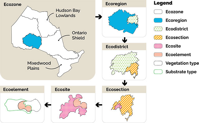
Ecozones
Ecozones are the largest of Ontario’s ecological land classification units.
Ecozones are defined by broad climate patterns and the type of underlying bedrock, which influence ecosystem processes and the plants and animals that can occur.
Examples of indicators calculated at the ecozone scale include:
For more information about ecozones read The ecosystems of Ontario — Part 1: ecozones and ecoregions.
View a map or download the boundaries of Ontario’s ecozones.
Ecoregions
Each ecozone contains many ecoregions.
Ecoregions are defined by patterns in temperature, precipitation, humidity and other climate variables.
We use ecoregions to:
- identify and assess significant wildlife habitat
- report on the status and trends of forest cover and disturbance
For more information about ecoregions read The ecosystems of Ontario — Part 1: ecozones and ecoregions.
View a map or download the boundaries of Ontario’s ecoregions.
Ecodistricts
Ecoregions are further subdivided into ecodistricts.
Ecodistricts are defined based on bedrock and topography. This determines local vegetation and habitats in each ecodistrict.
Ecodistricts are used to:
- develop natural heritage systems in municipalities
- identify ecological representation
- report on changes to total area of wetlands
For more information about ecodistricts read The ecosystems of Ontario — Part 2: ecodistricts.
View a map or download the boundaries of Ontario’s ecodistricts.
Ecosections
Ecosections are smaller than ecodistricts.
Ecosections are defined based on patterns in slope, landforms, soil texture and soil moisture. Examples of ecosections include:
- drumlin fields
- lake plains
Ecosections have not been developed or used in Ontario.
Ecosites
Ecosites are smaller than ecosections.
Ecosites are based mainly on physical features that influence what plant species are present, including:
- moisture
- slope
- soils
Each ecosite has a dominant vegetation type and substrate type. Examples of ecosites include:
- active sand dune
- rock barren
- sugar maple hardwood
Ecosites are used by sustainable forest license holders, resource managers, municipalities and conservation authorities for:
- land use planning
- sustainable forest management
- wildlife habitat management
You can access mapping through:
Ecoelements
Ecoelements are the smallest of Ontario’s land classification units. Ecosites contain many ecoelements. Each ecoelement has a single type:
- substrate
- vegetation
Ecoelements are used to understand the composition of ecosites and to support fine scale planning in southern Ontario.
Vegetation types (V-types)
Vegetation types are recurring groups of plants that grow in similar conditions. Ecologists use them to describe ecosystems. An example of a vegetation type is black spruce — feathermoss forest.
Substrate types (S-types)
Substrate types are the materials that plant species grow in. Ecologists define substrate types based on the:
- amount of water in the soil
- depth of the soil
- texture of the soil
An example of a substrate type is moderate depth, sandy coarse texture and moist.
Ecological land classification manuals
The following manuals provide detailed information on the description, identification, classification and mapping of ecological land classification in the Southern, Great Lakes-St. Lawrence and Boreal ranges:
- Ecological Land Classification for Southern Ontario: First Approximation and its Application 1998 (PDF)
- Ecosites of Ontario: Great Lakes-St. Lawrence Factsheets (PDF)
- Ecosites of Ontario: Boreal Ecosite Factsheets (PDF)
- Ecological Land Classification for Southern Ontario: Training Manual (PDF)
These manuals are for:
- land use planners
- natural resource managers
- municipalities
- other organizations or individuals
How to use the manuals
Use Figure 2 to identify the geographic range and which manual you need to use.
There are areas of overlap between geographic ranges, which means ecology determines the classification of an ecosite, rather than administrative boundaries.
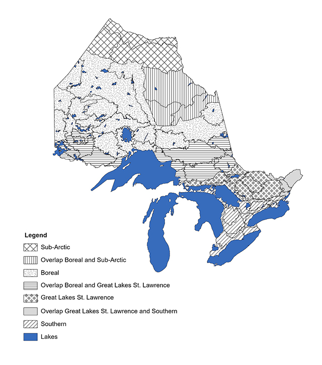
Figure 2. Geographic ranges of Ontario
Accessibility
We are committed to providing accessible customer service. If you need any of these manuals in an alternate format, contact us.
We will acknowledge emails and online messages within 2 business days and answer them within 15 business days.