Fisheries Management Zone 14 (FMZ 14)
Information about fishing and how fish resources are managed in Fisheries Management Zone 14 (Georgian Bay and North Channel of Lake Huron).
News and updates
We are currently developing a Walleye Management Plan and Non-Native Salmonid Stocking Plan with a broad base of participants including:
- FMZ 14 Council
- First Nations
- Métis
- commercial fishers
- other interested groups and individuals
Fishing rules
You can:
- find specific rules for fishing in FMZ 14
- use the Fish on-Line mapping tool
- find a complete set of fishing rules in the Ontario Fishing Regulations Summary
About this zone
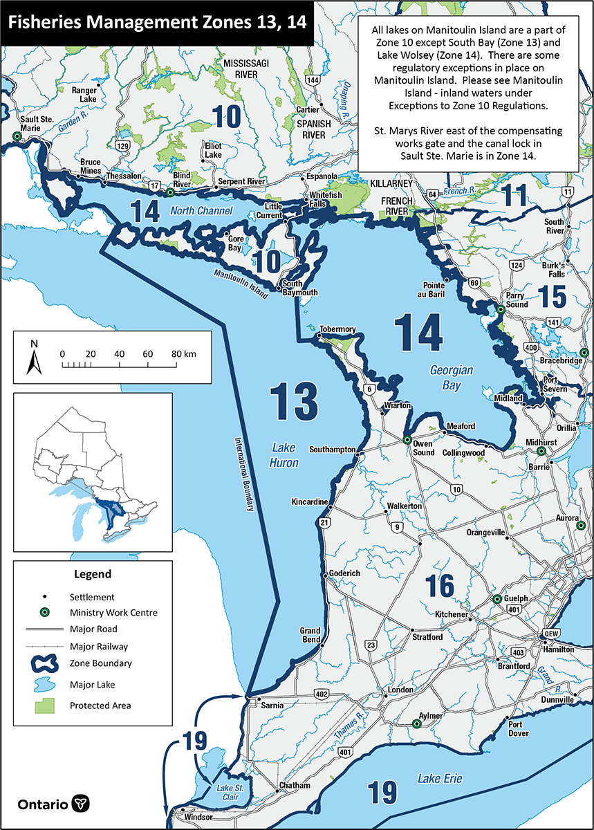
FMZ 14 includes the waters of Georgian Bay and the North Channel of Lake Huron. This zone has:
- the largest bay on the Great Lakes
- Thirty Thousand Islands, the world’s largest freshwater archipelago
- shoreline that includes Canadian Shield, glacial areas and limestone
- many tributaries draining the Canadian Shield
- farmland to the south
- near-shore fisheries for walleye, small and largemouth bass, northern pike, muskellunge, yellow perch
- offshore recreational fisheries for chinook salmon, rainbow trout and lake trout
- commercial fisheries for lake whitefish, walleye, lake trout, yellow perch
FMZ 14 is one of 20 fisheries management zones in the province.
Location
FMZ 14:
- includes the waters of Georgian Bay and the North Channel of Lake Huron
- stretches northwest to the compensation works on St. Mary’s River Sault Ste. Marie
- dividing line from FMZ 13 (the main basin of Lake Huron) begins at the tip of the Bruce Peninsula, goes through the Bruce archipelago to Manitoulin Island
- FMZ boundary extends across river mouths in most cases
- cities include Sault Ste. Marie, Blind River, Gore Bay, Little Current, Parry Sound, Midland, Collingwood, Owen Sound and Wiarton, and more than 20 First Nations communities
Legal boundary map and detail maps
Legal boundary map for FMZ 14 and detail maps 1 - 24.5 (PDF)
Regulation maps
- Beaver River – Thornbury (PDF)
- Bighead River – Meaford (PDF)
- Hog Creek – Victoria Harbour (PDF)
- LaFontaine Creek – LaFontaine (PDF)
- Nottawasaga River – Wasaga Beach (PDF)
- Nottawasaga and Boyne River – Alliston (PDF)
- Parry Sound and Surrounding Area, Georgian Bay (PDF)
- Pottawatomi River – Owen Sound (PDF)
- Pretty River – Collingwood (PDF)
- Sturgeon River – Waubaushene (PDF)
- Sydenham River (Owen Sound) (PDF)
Monitoring reports and management plans
- Joint strategic plan for Great Lakes fishery management
- Fish community objectives for Lake Huron
- The state of Lake Huron in 2018 (PDF)
Zone advisory council
The FMZ 14 council provides advice during the development of fisheries objectives and strategies.
Council members represent a broad range of views including:
- First Nation communities
- Métis Nation of Ontario
- angling groups
- commercial fishers
- scientists and researchers
- conservation groups
- interested community members
The advisory council participates in fisheries management by:
- sharing ideas and expertise with the ministry
- helping to develop and implement management strategies
- communicating with Indigenous communities, anglers, commercial fishers and other interested groups and individuals
For more information about the Fisheries Management Zone 14 advisory council, please contact the Upper Great Lakes management unit at
