Forest fires
Information about the current forest fire danger, forest fire activity and fire restrictions across the province.
Report a fire
 To report a forest fire call
 South of the French and Mattawa rivers please call 911.

Interactive fire map
Real time updates.
Our interactive map visually shows active fires, current fire danger across the province and restricted fire zones in effect.
The map now shows perimeters for some fires over 40 hectares in size. Please note that not all fires are mapped and perimeters are not updated every day (may differ from the size reported in the table).
We recommend using Google chrome as your web browser to access the map.
Ontario's fire season starts April 1.
Aviation, Forest Fire and Emergency Services would like to remind the public that during Ontario’s legislated fire season (from April 1 to October 31), Ontario’s Outdoor Burning Regulations are in effect. In order to dispose of yard waste and woody debris, we encourage you to use methods such as composting or using your local landfill. If you must burn, use caution and follow Ontario’s Outdoor Burning Regulations.
Fires are to be ignited no sooner than 2 hours before sunset and extinguished no later than 2 hours after sunrise. Always have tools/water adequate to contain the fire at the site. Know the rules for safe outdoor burning. Read the full set of Outdoor Burning Regulations.
Residents within municipal boundaries must also check with their local fire department for burning restrictions or permitting requirements prior to burning.
Forest fire updates
Northwest Region
Updated: July 14, 2025 - 6:15 p.m. CDT
New fires
Seven new fires were confirmed in the Northwest Region by the evening of July 14:
- Red Lake 103 (RED103) is located approximately 1 kilometre northeast of Windfall Creek, and approximately 14 kilometres west of Goose Lake. The 0.1-hectare fire is not under control.
- Red Lake 104 (RED104) is located near the northern shore of Lund Lake. It measures 0.3 of a hectare and is not under control.
- Red Lake 105 (RED105) is located half of a kilometre south of Lund Lake. The 0.1-hectare fire is under control.
- Red Lake 106 (RED106) is being held at 0.1 of a hectare, one kilometre north of Pipestone Bay of Red Lake.
- Red Lake 107 (RED107) measures 0.1 of a hectare and is not yet under control. It is located approximately one kilometre south of Pine Ridge road and 7 kilometres west of Hammell Lake.
- Red Lake 108 (RED108) is located near the southeastern shore of Storey Lake. The 0.1-hectare fire is not under control.
- Red Lake 109 (RED109) is located approximately 5 kilometres west of Goose Lake. It measures 0.1 of a hectare and is not yet under control.
At the time of this update, there are 54 active fires in the Northwest Region. Among them, 17 are not under control, 4 are being held, 6 are under control, and 27 are being observed.
The wildland fire hazard is low to moderate across the majority of the Northwest Region, while the Red Lake and Kenora sectors are showing a predominantly moderate to high hazard. Of note, the City of Thunder Bay and surrounding areas; an area located west of Wabigoon Lake; an area located south of Black Sturgeon Lake; as well as Slate Falls Nation and surrounding areas are showing a high hazard this evening.
For a closer look at fire hazard conditions in your area, see our Interactive Map.
Fires of note:
An Incident Management Team has been assigned to Red Lake 62 and a cluster of area fires.
Red Lake 12 - Deer Lake First Nation, Sandy Lake First Nation
- Red Lake 12 (RED012) is now being observed at 195,670.4 hectares in size.
Red Lake 62 – Pikangikum First Nation
- 10 Firefighting crews have been assigned across two divisions of the fire, supported by fire engines, heavy equipment and bucketing aircraft. Additional crews are incoming and will be added over the next few days.
- On the fire’s north division, crews are establishing hose lines and identifying new helipad locations in the northwest corner of the fire. Heavy equipment continues building fire guard along the fire’s northern perimeter.
- In Red 062’s southern division, crews are working to establish hose lines along the fire’s southeastern perimeter.
- Red Lake 62 (RED062) is 31,367 hectares in size and remains not under control.
Restrictions in effect - Red Lake 62
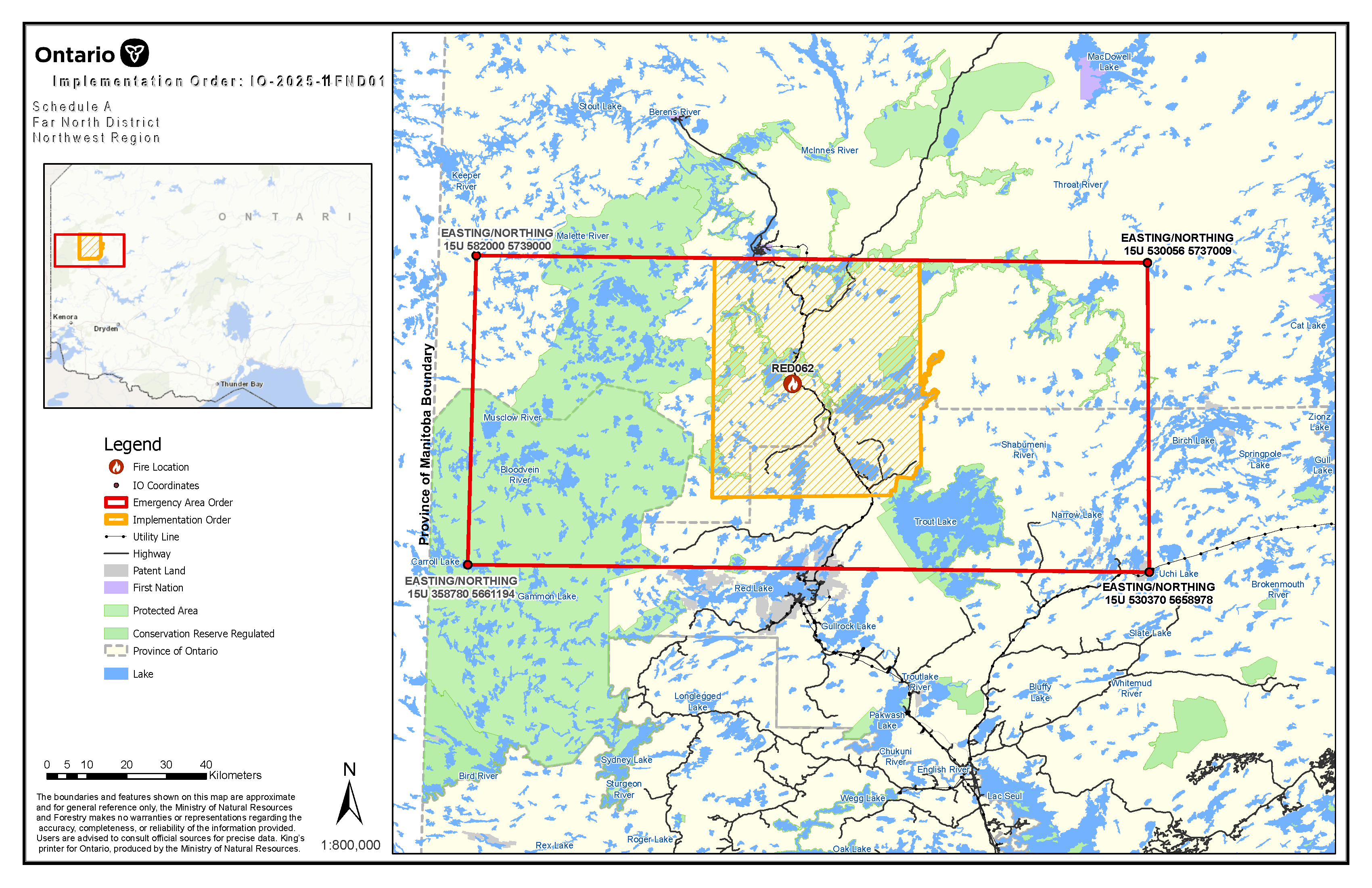
The Ministry of Natural Resources’ Far North District has invoked an Implementation Order now in effect for the purposes of public safety and/or effectual fire suppression, for areas near Red Lake 62 (RED062) Under the Emergency Area Order EAO 2025-011 declared on July 12, 2025.
Unless authorized by a travel permit issued by the Far North District office of the Ministry of Natural Resources (MNR), no person shall enter into the hatched area identified on the attached Implementation Order map, and all persons are encouraged to evacuate said area.
Specifically, all travel and use of the following areas is prohibited:
- Nungesser Road from (and including) the Coli Road junction north to Peekwatahmaewee Sahkaheekahn/Berens Lake.
- Coli Road Including the Coli Lake cottage subdivision and Coli Lake campground, Sidace Road, North Road, Caribou Road, Taxi Bay Road, Pikangikum Road.
- All other trails, winter roads, operational roads, and branch roads within the hatched area identified on the attached Implementation Order map.
All modes of travel and/or access, including aircraft, into the following areas are prohibited unless authorized by a travel permit issued by the Far North District office of the MNR:
- Nungesser Lake, Nungesser River, Coli Lake, Coli Creek, Sidace Lake, Stormer Lake, Wahshaykahmeesheeng/Kirkness Lake, Kirkness Creek, Peekwatahmaewee Sahkaheekahn/Berens Lake, Zimring Lake, Philp Lake, Pedlar lake, Pringle Lake including the Sahkeesahkahteekoh weesuhkaheegahn Dedicated Protected Area (Ontario Parks), Boughton Lake, Kavanagh Lake, Odin Lake, Kahnahmaykoosaysensikahk/Valhalla Lake, Maria Bay, Murfitt Lake, Upper and Lower Remote Lake, Dowling Lake, Dowling River, Hornblendite Lake, Harding Lake, Woodey Lake, Uren Lake, Lillycrop Lake, Baisley Lake, Minnett Lake, Treversh Lake, Sims Lake, Deebank Lake, Openshaw Lake, Lavis Lake, Teeple Lake, Rieger Lake, Sambells Lake, Peall Lake, Naylor Lake, Wyman Lake, Reigate Lake, Storey Lake, Toutin Lake, the north portion of Little Vermilion Lake, and the south portion of Peekahchekahmeewee Sahkaheekahn/Pikangikum Lake.
- All other waterbodies, Private Land, and Crown Land as outlined in the hatched area identified on the attached Implementation Order map.
Review the Implementation Order map here.
This Order is in effect at 12:01 am CDT on July 12, 2025, until such time as the order is revoked.
Requests for travel permits can be directed to Larissa Hutton, Far North District Office of the MNR at
Red Lake 40 – North Spirit Lake First Nation
- 3 crews have completed setting up sprinkler systems on critical infrastructure in the community of North Spirit Lake and are testing them for effectiveness.
- In the near term, crews will be placed on the fire’s northern perimeter to prevent its spread towards North Spirit Lake.
- Red Lake 40 (RED040) has been remapped to 8,789 hectares. The fire’s status is not under control.
Red Lake 67 – McDowell Lake First Nation
- Red Lake 67 (RED067) at a size 32,364 hectares. The fire is not under control.
- Structural protection (sprinklers) on buildings and critical infrastructure is complete at McDowell Lake First Nation and systems are being maintained.
- Structural protection efforts are also taking place south of the fire.
- At the first opportunity crews will establish hose line to secure the fire’s eastern perimeter on the peninsula nearest to McDowell Lake First Nation.
Red Lake 72 – east of Poplar Hill
- Red Lake 72 (RED072) is now measuring 4,941 hectares remains not under control.
- Four crews continue to extinguish spot fires on the east side of McInnes Lake and reclaim equipment for new hose lines.
Sioux Lookout 54 – Kitchenuhmaykoosib Inninuwug/Big Trout Lake First Nation
- Sioux Lookout 54 is currently measuring 176.0 hectares in size and is now being held.
- Crews continue to establish hose lines working along side bucketing helicopters to suppress the fire in priority areas.
Northeast Region
Updated: July 14, 2025 - 5:35 p.m. EDT
No new wildland fires were confirmed in the Northeast Region by the evening of July 14.
At the time of this update there are 8 active wildland fires in the Northeast Region. All 8 fires are being observed.
The wildland fire hazard ranges from low to high across the Northeast Region.
To view the fire hazard conditions in your area, see our Interactive Map.
Restricted fire zones
There are currently no restrictions in effect.
Contact information
Northeast Region
Evan Lizotte
Fire Information Officer
Northwest Region
Isabelle Chenard
Fire Information Officer
Red Lake 40, 62, 67 and 72
Chris Marchand
Fire Information Officer
Social media
Check out our Facebook, Instagram and X (formerly Twitter) accounts for safety tips and other forest fire related information.
For highway conditions, including road closures:
For air quality in your area, please visit:
public weather alerts for Canada
For smoke drift conditions across North America, visit:
smoke drift across North America
For information about forest fire smoke and your health, consult:
smoke and your health
Fires: year to date
The figures below represent the year-to-date total number of forest fires inside Ontario’s fire region for the 2025 fire season, as they compare to the 2024 season and to the 10-year average.
- 349fires in 2025
- 164fires in 2024
- 34810-year average
Fire bans in provincial parks
For all park fire bans see:
Ontario parks alerts
You are responsible for fires you light
From April through October, people using outdoor fires must follow strict guidelines under the Forest Fires Prevention Act of Ontario to ensure their fires are properly managed.
Anyone who starts a fire outdoors must take all necessary steps to tend the fire, keep it under control, and make sure the fire is out before leaving the site. A person failing to burn safely could be fined and held responsible for the cost of putting out the fire. People living in municipalities should check with local fire officials for bylaws on outdoor fires.
Hunters
- check the interactive fire map to find out where the active wildland fires are in Ontario.
- be aware of FireRangers who may be working in forested areas.
- check your surroundings for FireRanger activity before discharging your firearm to help keep everyone safe.
About Aviation, Forest Fire and Emergency Services (AFFES)
Visit our forest, wildland and outdoor fires page for more information on AFFES and wildland fire management, including: