Forest management: cultural heritage
Provides the direction for preparing and implementing forest management plans.
Acknowledgements
The Ontario Ministry of Natural Resources (OMNR) thanks the individuals on the revision team for their work to prepare this Guide: Dean Assinewe, RPF (North Shore Tribal Council – Forest Unit), Heather Barns, RPF (Forest Policy Section OMNR), Renée Carrière (Forest Management Planning Section, OMNR), Andrew Hinshelwood (Regional Archaeologist, Ministry of Culture), Susan Collins Lindquist, RPF (Chapleau District, OMNR), and Peter Street, RPF (Ontario Forest Industries Association). The Forest Policy Section and the revision team also sincerely appreciated:
- the Provincial Forest Technical Committee, particularly Dr. John Pollock and former committee member Dr. Jean-Luc Pilon for their time and advice on the review and development process, content, and pilot testing approaches for this forest management guide;
- those who attended and shared their experience at the Aboriginal workshops in June 2004 and Summer 2005;
- the Ontario Ministry of Culture staff who provided input;
- individuals and forest management planning teams who participated in pilot testing and socio–economic impact analysis of the guide to make it a better product for all planning teams;
- Dr. Emmanuel Asinas who did the socio-economic impact analysis;
- archaeologists who provided input based on their experience; and the many others who provided advice for the project and feedback on the drafts.
Preface/executive summary
This Guide replaces the previous guide: Timber Management Guidelines for the Protection of Cultural Heritage Resources (1991) (see section entitled Application of Guide). This new Guide gives an overview of what cultural heritage values are, their importance to society, and how they can be protected from potential impacts from forest management operations. For the purpose of this Guide, cultural heritage values have five classes: archaeological sites, archaeological potential areas, cultural heritage landscapes, historical Aboriginal values, and cemeteries. For each of these value classes, the Guide describes where to find information about the values, how to proceed when a value might be in more than one class, classified data awareness, roles in confirmation and verification of the values, and protection from forest management operations. The necessary monitoring to determine the effectiveness of the protection measures described in the Guide are discussed in the final section. The appendices deal with items such as the model used by the Ontario Ministry of Natural Resources to determine archaeological potential areas, integration of this Guide into forest management planning, and examples of how operational prescriptions might be documented in the applicable table in forest management plans. This Guide must be considered by forest managers when preparing forest management plans and carrying out forest management operations. The Ontario Ministry of Culture, through the Ontario Heritage Act, ensures that values like archaeological sites and archaeological potential areas receive the proper protection. Their legislation and policies must also be followed.
Summary of pilot testing
Condition 38e of the Declaration Order MNR-71 regarding MNR’s Class Environmental Assessment Approval for Forest Management on Crown Lands in Ontario requires new revised forest management guides to be pilot tested to assess their effectiveness and efficiency where feasible, with the advice of the Provincial Forest Technical Committee. Pilot testing of a draft version of this Guide was done on three forest management units: French Severn, Spanish, and Trout Lake Forests. Selected members of the planning teams for those management units received some general training on the draft Guide, read the draft Guide, and responded to scenarios they were given using the draft Guide. Based on this feedback a number of changes were incorporated into the Guide that make it clearer and easier to use. Ideas for training approaches were another important result of the pilot testing. Pilot testing on this Guide benefits all those who will use this Guide in the preparation of their forest management plans.
Summary of socio-economic impact analysis
The Ontario Ministry of Natural Resources is committed to doing a socio-economic impact analysis of all new forest management guides, as may be appropriate to the content of the guide. Socio-economic impact analysis has been undertaken in support of the draft Forest Management Guide for Cultural Heritage Values (Cultural Heritage Guide). The analysis is intended to quantify the wood supply impacts and give an indication of the wood costs, in order to consider the social and economic impacts of forest management guides.
The same three forest management units were used as for the pilot testing of the guide: French Severn, Spanish, and Trout Lake Forests.
A comparative impact analysis was undertaken to estimate the social and economic benefits and associated costs if the revised Cultural Heritage Guide (revised guide) is implemented in comparison to the current Timber Management Guidelines for the Protection of Cultural Heritage Resources (current guide) and to the what-if scenario of not having a guide at all (no guide). Hence, the scenarios of current guide, no guide and revised guide were used to compare and analyze the potential impacts of instituting cultural heritage values in forest management. The no guide scenario is not a realistic undertaking as there are statutory obligations that must be met. However, this scenario does assist in quantifying the basic benchmark of implications of cultural heritage protection measures.
There is no defined way to assess the value of cultural heritage values. Generally they are not considered in a monetary sense, but rather as their worth to the understanding of our history and to those who have an interest in them. Cultural heritage represents the subjective historical experience of the many diverse groups, cultures, institutions, and people of Ontario. It is an important part of cultural identity, and identity, in turn is often closely linked to cultural landmarks, economic interests, and contemporary cultural practice. Although the identification of values is key in providing information to planning teams for protection from forest management operations, the resources (e.g. people, time, money) to do this is often limiting. However there is great benefit in doing this work not only for the protection of the values, but also to the Aboriginal community in terms of capacity building.
Although there are social benefits to protecting values, there is also a cost to the industry using the resource. The provincially-approved Socio-Economic Impact Model was used to simulate the no, current, and revised guide scenarios for each forest management unit to obtain the social and economic impacts. The key difference between the Socio-Economic Impact Model runs and therefore the results, is the wood volume available for each of the three scenarios. The wood volumes are lower for the revised guide compared to the current guide. The annual differences are as follows: French Severn 137m3, Spanish 711 m3, and Trout Lake 306 m3.
With the implementation of the revised guide, the mills that depend on Trout Lake, Spanish and French-Severn forests will tend to lose total provincial sales of approximately $52,000, $70,000 and $18,000, respectively. These losses however, are quite insignificant; representing merely 0.03% (Trout Lake), 0.05% (Spanish) and 0.1% (French-Severn) of gross sales. The reductions for employment and tax revenues are correspondingly small.
These values are the potential net impacts that to anticipate by using the revised guide instead of the current guide. These net impacts represent the opportunity costs of not using the wood in order to maintain the cultural heritage values. These costs also represent the proxy value, in dollar terms that we can attribute to the value or price of cultural heritage values within our forests. Thus, in the perspective of people and entities concerned with cultural heritage preservation (such as Aboriginal communities and cultural institutions) these net impacts are social or cultural benefits rather than costs. Under a scenario of no guide versus current guide, the opposite holds true: the forestry industry will tend to gain in terms of gross sales, employment and tax revenues, while important cultural heritage values will not be preserved. However, the anticipated gains for the forestry industry are quite small and as previously indicated, the no guide scenario is not a viable option. To gather the information for the section regarding the effect of the Guide on wood costs, planning team staff for the three forest management units were asked to provide data on what types of increased costs there were for each of four value types and what those costs were. Briefly their findings were as follows. Archaeological sites and historical Aboriginal values showed little difference in cost between the no, current, and revised guide scenarios. Both of these value types would likely be protected in the same manner regardless of the existence of a guide. Archaeological potential areas did not show much difference between the current and revised guide scenarios, assuming that the area identified as a value is the same. However, there are higher costs for either of the scenarios compared to the no guide. If the no guide scenario was an option, there would still be costs of archaeological assessment, less operational flexibility, and possible relocation of operations. For cultural heritage landscapes Spanish Forest staff felt that the current guide causes larger reserves to be left which also substantially increases road building costs. Therefore their comment was that the new guide would have less cost to implement in this respect and the no guide scenario the least. It should be noted that under the no guide scenario, it is not realistic to assume that archaeological sites, archaeological potential areas, historical Aboriginal values, and cemeteries would not have similar or the same areas of concern prescriptions. There are very small wood supply and wood cost impacts due to this version of the Cultural Heritage Guide. This is due to the low number of cultural heritage values the relatively small size of reserves that protect them.
Based on the socio-economic impact analysis for the three pilot test sites, the implications on wood supply and costs appear negligible (0.03 to 0.1%). The opportunity costs of cultural heritage preservation therefore are miniscule in comparison to societal benefit in preserving these values. In a policy context, pursuing this revised guide is therefore beneficial in meeting our social, economic and ecological sustainability objectives. The complete Socio-Economic Impact Analysis Report for the Forest Management Guide for Cultural Heritage Values, December 2006 is on file with Forest Policy Section, Forests Division, Ontario Ministry of Natural Resources in Sault Ste. Marie, Ontario.
Application of guide
The application of this Guide is effective as of April 1, 2007. It must be used in the preparation of ten-year forest management plans (Phase I) beginning with plans scheduled for implementation in 2008 and planned operations for the second five- year terms (Phase II) beginning with planned operations scheduled for implementation in 2012 in accordance with the requirements of the Forest Management Planning Manual (2004). For plan amendments categorized by the OMNR district manager beginning April 1, 2007, to the extent reasonably possible, those amendments will be prepared in accordance with this Guide. For contingency plan proposals provided to the Ministry of the Environment for endorsement beginning April 1, 2007, the contingency plan will be prepared in accordance with this Guide. Section 3.8, Non-Compliance Remedies, will be used when dealing with situations of non-compliance found beginning April 1, 2007. The Notice of Decision is posted on the Ontario Environmental Registry.
Forest managers on all forest management units are encouraged to begin to use appropriate parts of the guide (e.g. data practices and non-compliance remedies). Maps of archaeological potential areas will be prepared and provided to planning teams in accordance with the schedule for forest management plan renewal.
OMNR’s strategic directions and statement of environmental values
The Ontario Ministry of Natural Resources (OMNR) is responsible for managing Ontario’s natural resources in accordance with the statutes it administers. As the province’s lead conservation agency, OMNR is the steward of provincial parks, natural heritage areas, forests, fisheries, wildlife, mineral aggregates, fuel minerals, and Crown lands and waters that make up 87 per cent of Ontario. In 1991, the Ontario Ministry of Natural Resources released a document entitled OMNR: Direction ‘90s which outlined the ministry’s goal and objectives. They are based on the concept of sustainable development, as expressed by the World Commission on Environment and Development. This document was updated in 1994 with a new publication, Direction ‘90s…Moving Ahead 1995, Beyond 2000, and updated again in 2005 with Our Sustainable Future. Within OMNR, policy and program development take their lead from Direction ‘90s, Direction 90s…Moving Ahead 1995, Beyond 2000, and Our Sustainable Future. Those strategic directions are also considered in ministry land use and resource management planning. In 1994, the OMNR finalized its Statement of Environmental Values under the Environmental Bill of Rights. The ministry’s Statement of Environmental Values describes how the purposes of the Environmental Bill of Rights are to be considered whenever decisions that might significantly affect the environment are made in the Ministry. The Statement of Environmental Values is based on the goals and objectives of the OMNR as described in Direction ‘90s, Direction ‘90s…Moving Ahead 1995 , Beyond 2000 , and Our Sustainable Future since the strategic direction provided in these documents reflects the purpose of the Environmental Bill of Rights.
During the development of Forest Management Guide for Cultural Heritage Values, the ministry has considered Direction ‘90s, Direction ‘90s…Moving Ahead 1995, Beyond 2000, Our Sustainable Future, and its Statement of Environmental Values. This Guide is intended to reflect the directions set out in those documents and to further the objectives of managing our resources on a sustainable basis.
Cultural heritage values overview
Flow chart showing the Cultural Heritage Values Guide The chart is divided into three columns where the last two columns showing examples and information for the question in column one which is titled “Which value class(es) (A cultural heritage value may be more than one class. Section 1.4 describes this in more detail.) does the cultural heritage value belong?
- Archaeological site: A location that is registered with the Ministry of Culture.
- Examples:
- Aboriginal village, pictograph
- For more information in this Guide:
- Description p. 9, data p. 18, and protection p. 28.
- Examples:
- Archaeological potential area: The output of the archaeological potential model, prepared by MNR and provided to planning teams by the provincial cultural heritage specialist.
- Examples:
- Maps provided by OMNR
- For more information in this Guide:
- Description p. 9, data p. 19, and protection p. 31.
- Examples:
- Cultural heritage landscape: A defined geographical area of heritage significance which has been modified by human activities and is valued by a community.
- Examples:
- Point: building or work,
- Linear: trail, portage, road, railway, traditional travel corridor,
- Polygon: fur trade post, logging camp.
- For more information in this Guide:
- Description p. 10, data p. 19, and protection p. 36.
- Examples:
- Historical Aboriginal value: Mapped places with cultural heritage value to an Aboriginal community.
- Example:
- Aboriginal brutal site, pictograph, fur trade post.
- For more information in this Guide:
- Description p. 12, Data p. 20, and Protection p. 42.
- Example:
- Cemetery: Where human remains have been buried and could contain grave markers, fences, mausoleums, or other structures.
- Examples:
- Cemetery, Aboriginal burial site
- For more information in this Guide:
- Description p. 16, data p. 20, and protection p. 44.
- Examples:
1.0 Cultural heritage values
1.1 Legislative framework
Ontario’s forest management planning system for Crown forests is based on a legal and policy framework that has sustainability, public consultation, Aboriginal peoples’ involvement, and adaptive management as key elements.
The Environmental Assessment Act and the Crown Forest Sustainability Act are the primary statutes that provide the legislative framework for forest management on Crown lands in Ontario. The Environmental Assessment Act defines the environment to include, among other things, “the … cultural conditions that influence the life of humans or a community, any building, structure, machine or other device or thing made by humans, … or any … interrelationships between … them”. This Act also has, as its purpose, “the betterment of the people of … Ontario by providing for the protection, conservation and wise management … of the environment.”
The Crown Forest Sustainability Act is Ontario’s key forestry legislation that provides for the sustainability of the Crown forest and governs forest management on Crown land. The Crown Forest Sustainability Act requires a forest management plan (FMP) to be prepared in accordance with the requirements of the Forest Management Planning Manual. The Forest Management Planning Manual, which incorporates the forest management planning requirements of the Crown Forest Sustainability Act and the provisions of the environmental assessment approval under the Environmental Assessment Act, contains the direction for preparing and implementing forest management plans. Consistent with forest management planning, forest managers plan to ensure the long-term health of Ontario’s forests, provide for a sustainable supply of benefits (e.g. timber and other commercial products, recreation opportunities, and wildlife habitat), while minimizing the adverse effects on forest values, including cultural heritage values.
The Forest Management Planning Manual (2004) requires that forest management guides, identified in the Forest Operations and Silviculture Manual (1995), be used in the preparation and implementation of a forest management plan. The Forest Information Manual (2001), currently under revision, prescribes the mandatory information and information products required by the Ontario Minister of Natural Resources and the forest industry.
The Ontario Heritage Act is administered by the Ontario Ministry of Culture. The legislation provides for the protection of properties of cultural heritage value or interest. Part VI of the Act speaks to the conservation of resources of archaeological value. According to the Act, an archaeological site must not be altered unless the work is conducted under the terms of a valid archaeological licence issued by the Ontario Minister of Culture. As permitted by Part VI of the Act, standard terms and conditions are attached to all archaeological licences issued. Among these conditions is a requirement that all archaeological field work conform to Ontario Ministry of Culture’s current standards and guidelines for consultant archaeologists. The Act also states that a detailed report of all archaeological fieldwork undertaken is to be submitted to Ontario Ministry of Culture for review. The Act and archaeological licensing terms and conditions direct matters such as the registration of archaeological sites, recommendations for protection, and mitigation of impacts to archaeological sites in development contexts and disposition of archaeological collections. Part III.1 of the Act states that standards and guidelines for provincial heritage properties will be developed. These standards and guidelines were being written by the Ontario Ministry of Culture at the time of this Guide’s approval. Any Ontario Ministry of Culture standards and guidelines that are developed for Crown land pertaining to the forest management context will need to be followed. This Guide does not supersede any legislation, regulation or order in council developed by the Ontario Ministry of Culture (e.g. Ontario Ministry of Culture Provincial Standards and Guidelines, Part III.1).
The experience with implementing the Timber Management Guidelines for the Protection of Cultural Heritage Resources (1991) and the work by and expertise of the revision team were key in preparing this Guide. This Guide was primarily written for planning teams to use when preparing and implementing forest management plans. However, others who are involved in the protection of culture heritage values in the forest management context (e.g. Aboriginal community members, Ontario Ministry of Culture staff, archaeologists performing archaeological assessments for Crown land forest operations, and Ontario Ministry of Natural Resources (OMNR)forest management planning specialists) will also find it helpful.
1.2 Cultural heritage values defined
Cultural heritage is defined in relation to the community which derives some sense of its identity from a shared history of beliefs, behaviours, or practices. For the purposes of this guide, the communities defined may be broad, such as the people of Ontario or members of Grand Council Treaty #3, or specific, such as farm pioneers of Jones County. Many communities that express an interest in cultural heritage are actively engaged in practices that are derived from the shared history and the actions of individual members of the community derive their sense of belonging through this practice. However, while cultural heritage is based on activities or beliefs of their forbearers, it is not necessary that the community continue to practice these traditions actively. Many heritage practices continue only in a ritualized form. One example would be an agricultural society which expresses a strong interest in preserving the cultural heritage of farming in a region, but whose members are largely engaged in non-agricultural professions, where the group preserves its identity through an annual “fall fair” or similar event.
Currently, the Ontario Heritage Act and regulations do not define cultural heritage, but in reviewing a number of Ontario Ministry of Culture documents the following definition is provided: cultural heritage is the memory, tradition and evidence for the historical occupation and use of a place, and the consideration of this evidence in contemporary society in developing group identities. Aboriginal people may view cultural heritage as an activity that continues to be practised, but in a different place from the past. This is not part of the definition for this Guide.
This Guide attempts to address the cultural heritage interests of diverse cultural groups. Their history of creating or using a landscape, and the physical features or structures that, through time, are important in the traditions, beliefs or institutions of the group constitute a cultural heritage value. This Guide includes provisions for the protection of cultural heritage values, as defined by this Guide, from potentially adverse impacts by forest management activities, in order that current and future members of the groups or students of cultural heritage might learn from or reflect upon them. Cultural heritage values for the purpose of this Guide are divided into five classes. Section 1.4 describes them.
1.2.1 Cultural heritage resources: Fragile, non-renewable and rare
Cultural heritage values are unique to the people who created them and the time they were created; therefore, they are non-renewable. For example, fur trading activity might be reflected in the archaeological record by the remains of subsoil building foundations and artifacts around them. Similarly, abandoned early community sites might hold significance for the individuals who occupied them or their families, descendants, or communities; abandoned railway towns or Aboriginal villages have fragile, intangible components that might not be recognized by others.
Most cultural heritage sites have experienced some level of deterioration from the time of abandonment. In the case of archaeological sites, cultural context might have become obscured through time, and much of the physical context might also have deteriorated. Nevertheless, the spatial relationships of materials on the site can provide considerable information on both cultural and physical context. It is critical that cultural materials (objects, artifacts, features, and sites) be viewed and valued in context.
1.2.2 Visibility of values
An important consideration in planning for cultural heritage values protection is the concept of visibility. The visibility of a value is related to how readily an individual could identify traces of the past occupation or activity undertaken at the site. Figure 1 demonstrates this through pictures of two building sites: one visible and the second invisible to most. For most archaeological sites, visibility increases with the abundance of material. Visibility, in terms of the number of objects present, may stand as a measure of archaeological significance, but for many historical Aboriginal values, significant cultural activities might have left limited physical traces. Visibility can also be described in terms of how well it can be seen under normal conditions. As an example, buried archaeological sites are not usually visible, while the visibility of abandoned mine headframes is obvious. For most values, visibility is affected by season of observation and vegetation cover.
Figure 1: Visibility of cultural heritage values
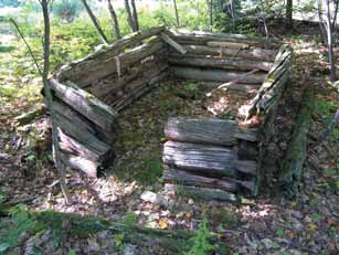
These two pictures demonstrate the range in visibility of values. The top one is a derelict milk house which is a few feet above ground. In the background of the other photo there is a small rise, caused by the foundation of an old building. This is an example of how cultural heritage values can be invisible to the untrained eye.
1.3 Possible effects of forest management activities on cultural heritage values
Forest management activities can be planned and carried out in a manner to prevent or minimize adverse effects on cultural heritage values. Although there may be a monetary cost to the forest industry in doing this, benefits are derived for all the participating parties. These benefits are listed along with possible adverse effects if this Guide did not exist or its standards and guidelines were not followed.
Potential beneficial effects
There are beneficial effects related to careful consideration of cultural heritage values in the planning and implementation of forest management activities.
Forest industry benefits:
- improved protection of cultural heritage values in forest management;
- improved relationship and trust between industry and Aboriginal community; and
- contribution to addressing conditions for most forest certification systems.
Aboriginal benefits:
- improved opportunity for Aboriginal communities to participate in forest management planning;
- information gathered from Elders before more knowledge is lost forever;
- continued development of historical Aboriginal values maps and databases; and
- improved relationship and trust between planning team and Aboriginal communities and individuals.
Public benefits:
- conservation of Ontario’s rich heritage;
- improved communication among forest users;
- increased awareness of local and regional cultural heritage; and
- increased understanding of forest management planning and forest operations.
Potential adverse effects
Forest management activities have the potential to cause a range of adverse impacts to cultural heritage values. Many of these impacts are considered to be long-term, permanent, and irreparable. Use of this Guide will prevent or minimize these effects.
Physical impacts:
- damage or destruction of physical or material features;
- loss of context information by damage to the relative horizontal or vertical location of artifacts with each other or to natural or cultural soil layers;
- changes to physical environment, accelerating natural rates of deterioration; and
- loss of plant, animal or forest cover associated with spiritual or ceremonial locations (e.g. medicinal plants).
Social impacts:
- interference with spiritual or ceremonial activities; and
- increased access to sites for artifact collecting and other inappropriate uses.
1.4 Classes of cultural heritage values
Five classes of cultural heritage values are defined for the purpose of this Guide. The five classes are:
- archaeological sites,
- archaeological potential areas,
- cultural heritage landscapes,
- historical Aboriginal values, and
- cemeteries.
The classes have been designed partially to reflect the group or agency which has the authority for their protection. The Ontario Ministry of Culture has authority over the protection of archaeological sites and archaeological potential areas. Historical Aboriginal values are gathered and protected in cooperation with an Aboriginal community. The Cemeteries Act governs how cemeteries must be registered and protected. For the most part cultural heritage landscapes can be identified by anyone and do not have legislation determining how they will be protected. Built heritage values, which are a component of cultural heritage landscapes, are protected by the Ontario Heritage Act, but at the writing of this Guide, the details are still being developed for Crown land.
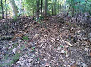
Figure 2: Venn diagram of cultural values relationships
The Venn Diagram in Figure 2 shows how a specific value, for example a fur trade post, could belong to two or three value classes.
This diagram illustrates how individual values may be described as belonging to more than one class. The overlap of values between classes is an important consideration in determining consultation requirements and developing protection measures. Other overlaps are possible (e.g. a cemetery may be part of a cultural heritage landscape.)
Five examples of cultural heritage values are placed within the Venn diagram to illustrate how specific sites may occupy a position within more than one values class.
Example 1: both a cultural heritage landscape, such as a nineteenth century farm community, and associated registered archaeological sites containing the remains of the farm house.
Example 2: a pictograph site might be identified as a historical Aboriginal value, as well as being registered as an archaeological site.
Example 3: a significant spiritual location identified as a historical Aboriginal value, which also appears as a nationally renowned work of art, is therefore a cultural heritage landscape.
Example 4: an early road (i.e. cultural heritage landscape) might follow a traditional Aboriginal peoples’ travel route and be associated with a number of registered archaeological sites.
Example 5: an Aboriginal peoples cemetery that is also a registered archaeological site and also is under the jurisdiction of the Cemeteries Act.
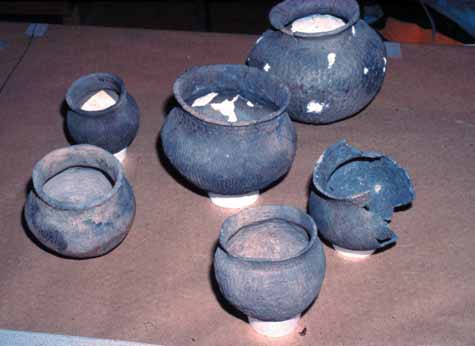
1.4.1 Archaeological sites
Regulations to the Ontario Heritage Act define archaeological sites as: any property that contains an artifact or any other physical evidence of past human use or activity that is of cultural heritage value or interest.
Sites are, therefore, defined on the basis of the presence of physical traces of past occupation. Specifically, artifacts are defined in the regulations as: any object, material or substance that is made, modified, used, deposited or affected by human action and is of cultural heritage value or interest.
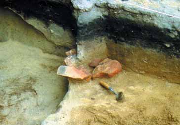
Figure 3: Archaeological site
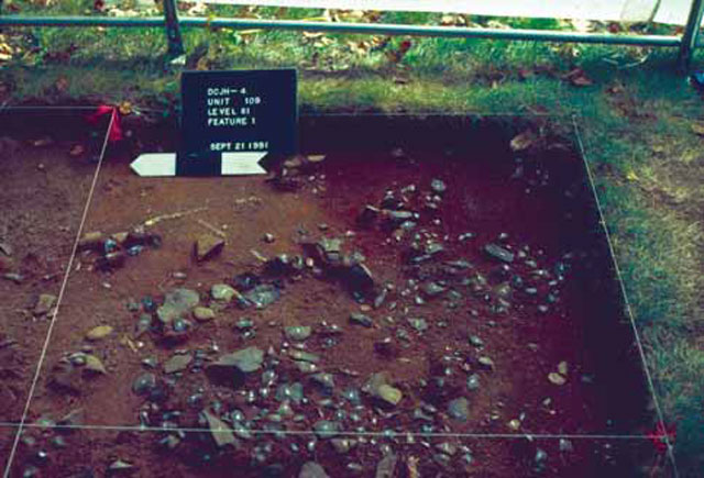
Archaeological sites generally have artifacts found only in the soil.
Figure 3 shows an archaeological site that is being excavated. Archaeological sites are found through the discovery of artifacts either on the surface of disturbed soil (e.g. beaches) or through excavation. For the purpose of this Guide, archaeological sites are defined as archaeological sites or marine archaeological sites registered with the Ontario Ministry of Culture. It is assumed that Ontario Ministry of Culture data is sufficiently accurate to support forest management planning and forest operations. All registered sites have a centre point. Sites that have been investigated in more detail will have established boundaries. The established boundaries will be found in the registration document or the associated report.
1.4.2 Archaeological potential areas
Archaeological potential areas are determined through the use of an archaeological potential area modelling tool. An example of a map showing the tool’s output is found in Figure 4. Archaeological potential area models identify areas that might contain archaeological sites based on the presence of specific landscape features that resemble the location and site conditions of known sites on the forest management unit.
Figure 4: Archaeological potential areas
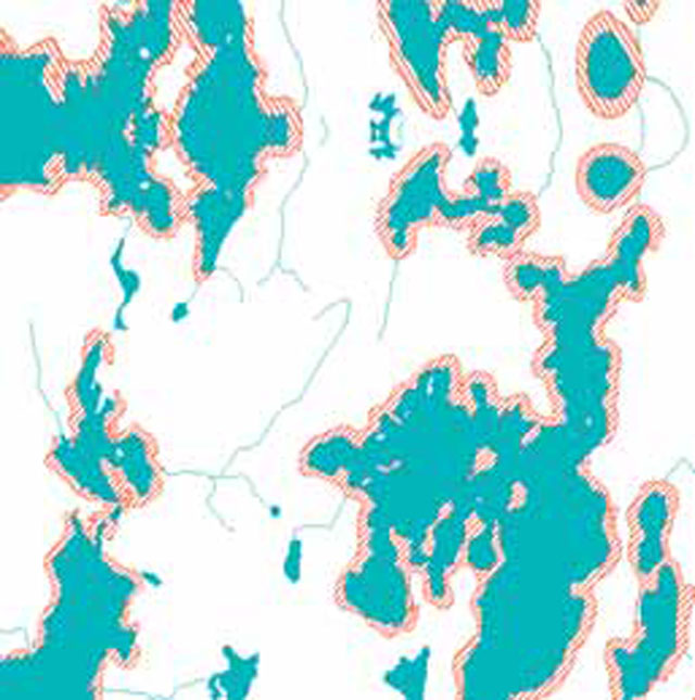
Archaeological potential areas that meet the data requirements of the Forest Information Manual are treated as known values in forest management planning.
Figure 5: Cultural heritage landscape
It is important to note that areas not shown as having potential might still have an archaeological site contained within them which, when discovered, would become a known value to be protected from forest management operations.
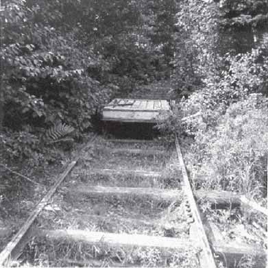
1.4.3 Cultural heritage landscapes
In this Guide, cultural heritage landscapes include both built heritage (i.e. structures) and larger areas of cultural heritage interest. This operational definition excludes individual registered archaeological sites or historical Aboriginal values, but does allow for cultural heritage landscapes that may be identified based on groupings of these values, or combinations of archaeological or historical Aboriginal values with other cultural landscape attributes. A cultural heritage landscape is a defined geographical area which has been modified by human activities and is valued by a community. Individual buildings, structures or travel routes (among other things) represent individual cultural heritage landscape features. Where these also occur in combination and/or along with archaeological sites, historical Aboriginal values, and cemeteries require treatment as one cultural heritage landscape value polygon. It is also common for discrete values to be nested within a cultural heritage landscape. For example, structural remains (e.g. buildings, partial walls or chimneys, stone piles, mining headframes, and wrecks) may be found in association with archaeological values. A cultural heritage landscape is a relatively small polygon area compared to the landscapes referred to in the Forest Management Planning Manual .
Typically, cultural heritage landscape values are grouped according to the cultural mechanism which has brought them into being. Designed landscapes are the result of planned human action, and include town sites, dams, mining sites, and transportation corridors. Evolved landscapes are the result of on-going or past use of the land, and include past forest operations, farm landscapes, and habitations that developed along road or railway corridors. Associate landscapes are those that have not been altered by human use, but have acquired cultural meaning through their connection to a notable person or a nationally renowned work of art. For the purpose of this Guide, cultural heritage landscapes are subdivided by whether they are mapped as points (e.g. buildings and wrecks), lines (e.g. roads and railway beds) or polygons (e.g. logging camp and abandoned townsite). The Ontario Heritage Act, Regulation 9/06 identifies criteria to be used in determining cultural heritage value or interest of built heritage values and cultural heritage landscapes. Under this Guide protection measures are provided for all of cultural heritage landscapes, but these criteria should assist in deciding when an expert is needed to help determine the protection needs. The defined area has design value or physical value because it, is rare, unique, representative or an early example of a style, type, expression, material, or construction method, displays a high degree of craftsmanship or artistic merit, or demonstrates a high degree of technical or scientific achievement.
The defined area has historical value or associative value because it, has direct associations with a theme, event, belief, person, activity, organization, or institution that is significant to a community yields, or has the potential to yield, information that contributes to an understanding of a community or culture, or demonstrates or reflects the work or ideas of an architect, artist, builder, designer, or theorist who is significant to a community. The defined area has contextual value because it is, important in defining, maintaining, or supporting the character of an area, physically, functionally, visually, or historically linked to its surroundings, or a landmark.
Figure 6: Historical Aboriginal value
1.4.4 Historical Aboriginal values
The Forest Management Planning Manual describes the requirement for the collection and consideration of Aboriginal values information to be considered in the preparation of forest management plans. Table 1 has a number of strategies to help OMNR and forest company staff identify and protect Aboriginal values in a manner that should help all parties understand each others concerns better. Members of the planning team and other involved OMNR staff will work in collaboration with participating Aboriginal communities to ensure that the objectives, scope, methodology and end use for data collected are agreed upon and documented. Methods used in gathering and collecting data should be decided with the Aboriginal community’s input. It is also vital that the planning team recognize the importance of working with Aboriginal communities to obtain the best possible data from the correct source and that there may be capacity issues for Aboriginal communities to participate.
Table 1: Best management practices for Aboriginal values identification
The approach for values identification must be established with each of the participating Aboriginal communities. The following strategies might prove effective in the identification and protection of Aboriginal values:
- Determine if there is an existing consultation policy at the local or regional level that will form the basis for this process;
- Remember that the relocation of some Aboriginal communities means that they are now located a distance from their original site. Many Aboriginal communities will be interested in participating in areas where their community was historically;
- Provide advance notice of the planning schedule and interest in Aboriginal values.
- Propose a timeframe for discussion;
- Work towards building long-term and continuous relationships with the community.
- Recognize that good relations will result in more comprehensive values data; this is of benefit to the OMNR, the forest industry, and the Aboriginal community;
- It may be helpful to have agreement with Chief and Council as to how the values collection and protection work will be done (e.g. who, when, and resources available);
- The establishment of an Aboriginal Advisory Committee as a sub-committee of the forest management planning team might be helpful. It would be comprised of members from participating Aboriginal communities;
- Recognize that a number of shorter community visits to discuss a specific item will build better relationships and yield better information than one or two “road show” type community visits. Visits can be timed to coincide with community events where a larger number of members are present;
- Recognize that multiple requests for values information might be made to the communities. MNR should try to coordinate requests from varying program areas;
- Develop strategies with the community to assist them in responding to requests for values data to other government initiatives;
- Develop a data loan or memorandum of understanding with the community. Establish a protocol for ensuring the security of classified data;
- Understand that few communities have the capacity to provide “plan-ready” data, so have a strategy in place to deal with this issue. As with all values, Aboriginal values may be identified at any time;
- Values that were identified during a previous plan term might now have more information available;
- Previous forestry issues and other issues beyond the scope of the Forest Management Plan (FMP) might be brought into the discussion. Discuss with the community whether to gather values at the community, family and/or individual level(s). Often traditional land use within a traditional territory follows clan or family lines; therefore, the local knowledge for many areas might be found within families;
- Skilled interpreters are needed in data collection to ensure that the values presented in the
- Aboriginal language are not lost in translation;
- Values, interests, historic uses, and rights are inseparable to many Aboriginal communities.
- Ensure that issues outside of the scope of forest management are referred to the appropriate
- OMNR staff person to discuss further with the Aboriginal community;
- Due to cultural tradition, some values, for example medicinal plants, may not be identified even to other community members despite their importance;
- Some Aboriginal values might have been lost from the collective memory of an Aboriginal community, for example, if they were not passed on by an Elder. The discovery of an artifact might be the only way that this missing piece of memory is retrieved;
- Remain aware that point values often represent one set of cultural activities nested within a larger area representing a related set of cultural activities. For example, the area surrounding a ceremonial site that is described as supporting the ceremonial action should be considered as part of the value;
- Endeavour to understand the value and all that it entails. This understanding will help in the determination of the appropriate protection requirements for it;
- Levels and approaches to values protection proposed for particular classes of cultural heritage values should be developed in cooperation with the Aboriginal community or individual reporting the value; and
- Field examinations to locate values and establish Aboriginal values site boundaries should be conducted by a person designated by the community (e.g. Elder or person reporting value).
The Aboriginal Background Information Report, as required by the Forest Management Planning Manual, includes an Aboriginal values map which identifies values of importance to the participating community including historical Aboriginal values. These sites might include those of local archaeological, historical, religious, and cultural heritage significance (e.g. Aboriginal cemeteries, spiritual sites, and burial sites.)
Aboriginal values are important. However, only historical Aboriginal values are addressed by this Guide. Other Aboriginal values may be addressed through other guides or even perhaps through the forest management planning process. Some Aboriginal values are best addressed in the forest management planning process when the planning team is deciding on the long term management direction and landscape level matters concerning access and landscape pattern development. Other Aboriginal values may be addressed by other forest management guides such as those dealing with culturally significant species and their habitat (e.g. eagle nests). Therefore, for the purpose of this Guide, historical Aboriginal values are those which can be mapped and fit the cultural heritage definition in Section 1.2. Nevertheless, it is important to recognize from the outset that the range of historical Aboriginal values and interests can be diverse and interconnected and need not contain physical remains (as discussed in the caption for Figure 6). When these values are outside of the scope of this Guide, it is important that they are identified to the appropriate OMNR staff person so that they can further discuss them with the Aboriginal community.
Historical Aboriginal values may be point, line or polygon values. In rare cases, there will be times when historical Aboriginal values will be described in general terms at the start of planning, with the understanding that additional detail about the values will be provided at the annual work schedule stage so that specific protection measures can be determined and amended to the forest management plan for implementation.
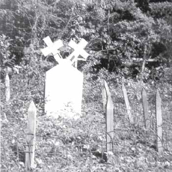
Figure 7: Cemetery
The Aboriginal language used in describing the value might convey a level of subtlety or cultural meaning that is absent in an English translation of the terms used. Traditional geographic names within the forest management unit might also provide insight into historical Aboriginal values.
1.4.5 Cemeteries
Burial sites and cemeteries are locations where human remains have been interred, usually accompanied by attendant ritual or ceremony at the time of burial. The Cemeteries Act distinguishes between cemeteries and burial sites. A cemetery is land set aside to be used for the interment of human remains. A registered or approved cemetery is one which has been approved for use by the Registrar of Cemeteries.
A burial site is defined as land containing human remains that has not been approved or consented to as a cemetery in accordance with legislation. As a consequence of the investigation process described in the Cemeteries Act there may be approved cemeteries, unapproved cemeteries, or irregular burials within a forest management unit. For the purpose of this forest management guide cemeteries and burial sites are both referred to as cemeteries.
Not many registered cemeteries are present on Crown lands; however, abandoned cemeteries associated with early settlements, Aboriginal cemeteries, and burial sites should be expected on all forest management units.
Cemeteries may be accompanied by a range of markers (Figure 7 showing two types) that identify the location of individual interments, the boundaries of the site or serve other related functions. According to the Cemeteries Act, “marker means any monument, tombstone, plaque, headstone, cornerstone, or other structure or ornament affixed to or intended to be affixed to a burial lot, mausoleum crypt, columbarium niche or other structure or place intended for the deposit of human remains”, and is integral to the cemetery.
2.0 Cultural heritage values data
The protection of cultural heritage values begins with the development of comprehensive datasets. Developing the necessary datasets will be an on-going task since few complete datasets currently exist. It is expected that there will be more and better quality information for each successive forest management plan.
As data for each of the five classes of cultural heritage values are compiled, it is necessary to review them for completeness and accuracy, identifying gaps in the available data, noting specific issues surrounding classified data, and providing the data for incorporation into the forest management plan (FMP). Since some of this data is provided by agencies other than Ontario Ministry of Natural Resources (OMNR), it is important that data requirements and FMP timelines are communicated to those agencies providing information (e.g. Ontario Ministry of Culture) at the start of planning. The roles and responsibilities for identifying and confirming the values information by the various parties are described for each values class.
Appendices II and III describe when data are collected and assessed and by who during the forest management planning process.
2.1 Data sources
Sources for data to build a comprehensive cultural heritage values inventory are diverse; however, OMNR is not the principal custodian for much of this data. For example, registered archaeological site records are maintained by Ontario Ministry of Culture and historical Aboriginal values information resides with the Aboriginal community or individuals. Some data can be gathered from primary and secondary historical sources as part of the assembly of background information by OMNR, although developing comprehensive data in this way represents a long-term project. Table 2 identifies sources for data on cultural heritage values.
New values identified during plan implementation will be added to the database.
2.1.1 Archaeological site data
Ontario Ministry of Culture maintains a database of registered archaeological sites. Data for any given management unit is to be provided to the OMNR prior to the start of planning in support of site protection and archaeological potential area modelling.
Table 2: Some sources of cultural heritage values
Converted to list for accessibility
Ontario Ministry of Culture
- Ontario archaeological sites database,
- unverified site files, and
- archaeological fieldwork reports.
Ontario Ministry of Natural Resources / Sustainable forest licence holders 19
- archaeological potential area mapping,
- FMP related archaeological assessment reports,
- district Sensitive Area files,
- Crown Land Use Atlas,
- old forest management maps, records, and reports,
- district cultural heritage information in the Natural Resource Values Information System;
- Ontario Parks – park management plan background studies, park libraries and archives,
- information from district or company staff and local citizen committee members, and
- old forest inventory and topographic maps, and aerial photos.
Aboriginal communities
- Aboriginal values mapping (e.g. Aboriginal Background Information Report), and
- Aboriginal community consultations, individual or family interviews.
Other sources
- primary and secondary historical sources (e.g. books, journals, maps, and atlases),
- original Crown survey maps and notes,
- Ontario Bureau of Mines Reports,
- Ontario Ministry of Northern Development and Mines
- closed/abandoned mines database,
- community museum societies, historical societies, local historians or residents, Women’s Institutes, etc., and
- internet .
2.1.2 Archaeological potential area data
The archaeological potential area data is provided by OMNR. The archaeological potential area maps are developed using a variety of geospatial map layers as base data for modelling, and includes consideration of both the Ontario Ministry of Culture registered site information and the available cultural heritage landscapes and historical Aboriginal values data as the basis for calibrating the model. The methodology OMNR currently uses in developing the final archaeological potential area maps is described in more detail in Appendix I. There is a role for the FMP team in this process.
2.1.3 Cultural heritage landscapes data
There are few formally defined cultural heritage landscapes in central and northern Ontario, and no comprehensive planning databases for cultural heritage landscapes are available. Some information sources have been assembled under the Ontario
Heritage Properties Database which is available via the Ontario Ministry of Culture’s web site. This database lists properties designated at the municipal level under the Ontario Heritage Act, properties that are owned, protected or recognized by the Ontario Heritage Trust, and other formally recognized properties (e.g. the Ontario Heritage Bridge List and National Historic Sites.) It should not be regarded as a comprehensive list. Additional cultural heritage landscape data might be derived from primary and secondary historical sources: books, journals, maps, and atlases. Forest company and OMNR (including Ontario Parks) records might also contain information on important cultural heritage landscape values, such as early logging camps. Local organizations, such as heritage societies and community museums or individuals, might also have information. Generally, no one owns the data, but it is stored by the OMNR.
2.1.4 Historical Aboriginal values data
Aboriginal Background Information Reports include a values map showing Aboriginal values and therefore is the key source of the historical Aboriginal values data pertinent to this Guide. Historical Aboriginal values that are provided must be considered in the planning process. The OMNR planning team member assigned the role of contact with Aboriginal communities will likely be the primary contact for this data. Although historical Aboriginal values data can be submitted at any time, the earlier that such data are provided in the planning process the better, to ensure consideration during the development of the plan. OMNR can work with Aboriginal communities to ensure the data collection and documentation are in a form easily utilized in the forest management planning process.
2.1.5 Cemetery data
Cemetery data can be compiled from three sources:
- Information on registered cemeteries, including unapproved cemeteries within the forest management unit may be obtained from the Registrar of Cemeteries of the Ministry of Consumer and Business Services. The Cemeteries Regulation Unit maintains a database of registered cemeteries. This information may also include incomplete records or reports of other unapproved cemeteries that are located on Crown land.
- Local information from individuals, Aboriginal communities, historical societies, and other groups with historic connections to areas within the forest management unit.
- Early land records and surveys may provide indications of where cemeteries are located.
2.2 Classified information
OMNR is responsible to ensure that classified data (i.e. sensitive) are protected, secure, and managed in accordance with the Ontario Ministry of Natural Resources Policy for the Management of Classified Data in the Ontario Land Information Warehouse (in preparation). Classified data are only to be made available for specific purposes to specific people on a need to know basis. OMNR should also determine if additional data loan/sharing agreements are needed to cover information provided from other sources such as an Aboriginal community.
The OMNR district staff person who has access to cultural heritage values data should review all proposed forest management activities during the preparation of the forest management plan and any plan amendments to ensure that the values in areas of operations are protected.
The specific locations of classified values are not to be shown on the public versions of maps used for forest management purposes. Documented protection measures for classified values must be done in such a manner as to not disclose the value.
2.2.1 Archaeological sites
Ontario Ministry of Culture is the custodian for all registered archaeological site data and therefore sets conditions to access this data. Archaeological sites are classified data.
2.2.2 Archaeological potential areas
Archaeological potential areas are not considered classified information even though unknown classified sites might be contained within their boundaries. Archaeological potential areas are required to be shown on values maps and on maps showing proposed forest management activities.
2.2.3 Cultural heritage landscapes
Most cultural heritage landscape data is unclassified, although occasionally a cultural heritage landscape may be classified due to specific classified values found within it. Locations for individual structures, such as buildings or constructed landmarks might be highly susceptible to damage and should be considered classified information. For example, colonization roads might be associated with known classified sites; therefore, sections of the colonization road may also be considered as classified information. Determining whether a cultural heritage landscape should be considered as classified must be done on an individual basis.
2.2.4 Historical Aboriginal values
All historical Aboriginal values information is owned by the Aboriginal community that provides it. The data are considered classified unless indicated otherwise by the Aboriginal community. Therefore, the information will not be shared within anyone other than the persons indicated in a data loan agreement or memorandum of understanding between the Aboriginal community and the OMNR district. These agreements should include:
- term of the agreement;
- description of the data being loaned or shared, its format, etc.;
- contact names for OMNR and the community;
- who has access to the data (e.g. other OMNR program areas to avoid more requests for the same information);
- how data will be protected and used, including specific provisions for
- Aboriginal community participation in the field lay out of areas of concern;
- how to proceed if a value cannot be located in the field; and
- proper instruction of field staff regarding the values.
2.2.5 Cemeteries
Records of registered cemeteries are on file with both the landowner and the Registrar of Cemeteries and therefore are public records. Cemetery locations are not considered classified and should be shown on values maps and maps showing proposed forest operations.
2.3 Data standards
The Forest Information Manual identifies the criteria that values data are required to meet in order to be considered known values for the purposes of forest management planning. For a value to be considered a known value, sufficient information must be available to describe its geographic location and basic features. Data which do not meet the standards of the Forest Information Manual are not considered as known values for the purpose of planning. In such cases, the OMNR will ask the provider for the necessary information. The basic description information required for known values includes: identification of the value by class or category (sub-class), information source, accurate location, description of the physical characteristics of the site, and any other specific information required to decide on the appropriate protection.
2.4 Identifying values and ensuring location accuracy
The Forest Information Manual describes the process for identifying and confirming values. It is expected the current terminology of confirmation and verification will change once the new Forest Information Manual comes into effect (expected spring 2007). The terminology and responsibilities described in the Forest Information Manual take precedence over the explanation included in this Guide.
At the time of preparing this Guide, the term confirm describes the roles and responsibilities of the data provider. The provider of values information must confirm that information provided is accurate and meets the standards described in the Forest Information Manual. Verify describes the roles and responsibilities of the receiver (i.e. generally for this Guide, the sustainable forest licence holder). The receiver of values information must verify that the information received is accurate and conforms to the Forest Information Manual.
2.4.1 Archaeological sites
For archaeological sites, no confirmation or verification is necessary. However, there might be times when the receiver of the information wishes to do more investigation.
2.4.2 Archaeological potential areas
OMNR is responsible for confirming archaeological potential area maps. Confirming archaeological potential areas includes analysis to ensure that the modelling output conforms to the base landscape data and assumptions of the model calibration. Additional information, detailed mapping, photography, and descriptions provided by field staff familiar with the area, can assist in identifying areas that do not conform to the definition of potential. Confirmation does not determine the presence or absence of archaeological site locations within the potential areas, since this is part of the archaeological assessment.
Appendix I provides detailed information on the confirmation of potential modelling results.
Verification, when necessary, is the responsibility of the receiver of the information and must be completed by a licensed archaeologist. Verification may be completed as an archaeological assessment when the objective is to document archaeological sites within the area of concern.
2.4.3 Cultural heritage landscapes
OMNR is responsible for confirming any cultural heritage landscapes data. Cultural heritage landscape values verification does not need to be completed as archaeological assessments. However, certain cultural heritage landscape values could require investigation by a specialist (e.g. buildings and cultural heritage landscape level features that might be associated with archaeological sites).
If a value cannot be located because of insufficient positional accuracy, the OMNR district should be contacted per the Forest Information Manual. If after further checking the site still cannot be found regular operations can proceed, with a provision to stop operations if the value becomes evident.
Where the data provided by OMNR are from an outside party, that party is responsible for confirming and documenting that the data provided meets Forest Information Manual data standards. As cultural heritage landscapes are identified, the information should be reviewed to determine whether they have been described in sufficient detail to meet the data requirements of the Forest Information Manual and can be considered as known values for the purpose of forest management planning. The most effective method for confirming the values is through additional discussion and review of detailed mapping of the value with the provider. In addition, the information received should be reviewed by the planning team to determine whether there is sufficient information to allow specific protection measure(s) for the value to be developed, or, if this information is not immediately available, whether it can be readily obtained.
2.4.4 Historical Aboriginal values
Verification of historical Aboriginal values is usually done as part of the discussions with the participating Aboriginal community and with the active participation of the qualified individual as identified by the Aboriginal community (see Section 3.0). The Aboriginal community may wish to document boundaries or the core areas of the value and/or evaluate the significance and sensitivity of the value to help determine the protection needed. Those involved in the process will decide on a timeline for this that will fit with the schedule for preparing the forest management plan.
2.4.5 Cemeteries
Cemetery data from the Registrar of Cemeteries do not need to be confirmed or verified. If during forest operations it becomes apparent that the cemetery location is incorrect then the proper location must be protected.Where the data provided to OMNR are from a party other than the Registrar of Cemeteries, that party is responsible for confirming and documenting that the data provided meet Forest Information Manual data standards or are sufficient for planning.
3.0 Protection of cultural heritage values
The principal focus for the protection of cultural heritage values should be to prevent or minimize physical damage to values through planning of reserves and modified operations. Indirect impacts, such as changes in visibility or accessibility of values as a result of operations, also need to be considered in the planning of operations. Other forest management guides deal with forest site damage issues, such as mitigating against potential soil erosion and rutting. Besides the negative effects to forest health, site disturbance can also damage or destroy cultural heritage values.
For those values for which specific protection measure(s) are given in this guide and the protection measure(s) are used in the forest management plan, a qualified individual will normally not need to be involved. Archaeological sites and archaeological potential areas must be protected per Ontario Ministry of Culture requirements. Therefore the Guide’s sections that discuss the protection of these areas refer to archaeological assessments. There are four stages of archaeological assessment. Most common for forest management, Stage 2 is conducted to ascertain whether there are any archaeological artifacts within a specific area. A summary of all of the stages can be found in the glossary under Archaeological Assessment. For a full explanation, see the Ontario Ministry of Culture’s current standards and guidelines for consultant archaeologists. Prescriptions for operations in areas of concern are recorded in forest management plans in a table referred to as FMP-14. Appendix IV provides examples of completed
FMP-14 tables based on the standards, guidelines, best management practices, and information presented in this section. Any new cultural heritage values in areas of planned operations identified during plan implementation (e.g. by a member of the public or during forest operations) will be protected as prescribed by this Guide. In the case of a new value being found during forestry operations, work must cease in the area of the find immediately. Section 3.7 gives advice regarding who must be contacted and protection of the value. Usually protection of cultural heritage values is in the form of a reserve or modified operations. There are cases where some values, for example old road beds, do not require an area of concern, but documentation must take place instead. This documentation may be in the form of photographs and notes about the state of the value, what it looks like, what materials make it up, its proximity to other objects in the area, notes of interest, etc. This documentation should be shared with the Ontario Ministry of Natural Resources (OMNR) district office and the OMNR provincial cultural heritage specialist.
Standards and guidelines are bolded. Standards are mandatory direction. Guidelines also provide mandatory direction, but require professional judgement to be applied appropriately at the local level. Best management practices, defined as practices at an exemplary level of performance, are also included in this Guide. Forest managers are encouraged to adopt those best management practices that are pertinent to their area.
3.1 Protection –general
The following guidelines and best management practice apply to all five classes of cultural heritage values.
Guidelines
- Marking the area of concern boundaries of classified sites must not draw attention to the purpose for which the area of concern is established (e.g. use the same flagging tape as for other nearby areas of concern).
- In developing protection measures,
- be aware that a value might belong to more than one value class, (e.g. a historical Aboriginal Value that is also an archaeological site as in Figure 8 or the archaeological component of a cultural heritage landscape.) In such cases, the protection strategies for the other value class(es) must also be
- applied and more than one qualified individual might need to be involved.
- There will be consideration of visual aesthetics, which may include the use of viewscape analysis techniques, in the development of the protection measure(s) where mature forest is integral and adds further meaning to the value (e.g. where a view at the location forms a nationally renowned work of art, provides context for the actions of a well known historical figure, or is integral to contemporary use of a traditional spiritual site.)
Figure 8: Value belonging to two value classes
Best management practice
- Sometimes the layout of the harvest area can be altered to avoid a cultural heritage area (e.g. leaving a cultural heritage to meet direction provided in another Guide).
3.2 Archaeological sites
The planning team may choose to accept the Ontario Ministry of Culture’s archaeological site data and apply the reserve dimensions in the standards. Alternately a licensed archaeologist can be hired to:
- review additional information which might be available in the Ontario Ministry of Culture archaeological site registration forms and published and unpublished archaeological reports; and/or
- conduct an archaeological assessment as prescribed by the Ontario Ministry of Culture.
This is outlined in some of the following standards and in Figure 9.
In any case where an archaeologist has made a recommendation for protection of the site, the supporting report must be sent to and reviewed by Ontario Ministry of Culture staff. Archaeologists recommendations will normally be followed, at a minimum, since they are made to ensure their clients’ projects comply with the Ontario Heritage Act.
The following standards, guideline, and best management practice apply to archaeological sites.
Standards
- The reserve must extend at least 200 metres from the defined centre of the site unless:
- the boundary of a site has been delineated through a Ontario Ministry of Culture Stage 3 archaeological assessment, in which case the reserve is a minimum of 10 metres from the boundary; or
- a Stage 4 excavation has been completed to meet Ontario Ministry of Culture standards and a recommendation has been made by a licensed archaeologist that no further archaeological work is required in which case a reserve is no longer required; or
- the sustainable forest licence holder chooses to engage a licensed archaeologist to collect and report on information from the Ontario Ministry of Culture. Then one of the following three situations could occur:
- If the review suggests that the archaeological site is possibly large or has great cultural heritage value or interest, then keeping the 200 metre radius reserve or creating a larger reserve will likely be recommended. An Ontario Ministry of Culture archaeological assessment can be done to establish the boundaries of the site and from this, a 10m buffer can be established from the boundary.
- If the review suggests that the site is small or registers the location of an isolated find (e.g. arrowhead), and this conclusion is supported by documentation such as field notes, a report, or the results of an archaeological assessment, then the archaeologist could make a recommendation to remove the reserve since it does not provide protection of a tangible material resource.
- If the review shows that the site is of another class of cultural heritage value for which direction is provided in this Guide (e.g. cabin), then the archaeologist could make a recommendation to substitute more appropriate protection.
- The following are not permitted within archaeological site reserves:
- harvest, renewal and tending activities,
- new roads, landings, or water crossings.
- Maintenance and use of existing roads is permitted.
Figure 9: Key for alternative protection possibilities for archaeological sites
- Receive registered archaeological site data from Ontario Ministry of Culture.
- Accept data and protect with prescription as required by standards in the Guide.
- Hire an archaeologist to do a Stage 3 and/or Stage 4 archaeolgical assessment.
- Hire a licensed archaeologist to contact Ontario Ministry of Culture for site forms and reports.
- Archaeological Site.
- Established boundary-10m reserve.
- Non-established boundary -200m reserve or larger dependingon site
- Building or other above ground built feature (e.g. retired aircraft land strip).
- If no further investigation, then evaluation by qualified individual.
- If further investigation previously and boundaries determined, then use appropriate protection.
- Isolated archaeological find (e.g. lone arrowhead).
- If no further investigation previously, then a Ministry of Culture Stage 2 is done.
- If nothing found - no protection required. Document work in FMP.
- If more archaeological features found - protect as recommended by licensed archaeologist.
- If further investigation previously, then no protection required. Document.
- If no further investigation previously, then a Ministry of Culture Stage 2 is done.
- Archaeological Site.
Download Figure 9: Key for alternative protection possibilities for archaeological sites (PDF)
When a licensed archaeologist is hired to review additional information which might be available in the Ontario Ministry of Culture’s archaeological site registration forms and reports, then there are several possible outcomes. These possibilities are summarized in this figure and discussed further on pages 29 and 31.
Guideline
- Data that indicate that a site has greater cultural heritage value or interest will require individual protection measure(s) based on specific site features. The protection measure(s) will be determined through discussions among Ontario Ministry of Culture staff and OMNR’s provincial cultural heritage specialist. In those cases where a licensed archaeologist found the site while working for the sustainable forest license holder, they will also be engaged in the discussions.
Best management practice
- Reserve dimensions should be increased if there is an identified risk of:
- archaeological site disturbance resulting from windthrow of residual trees; or
- increased access to the archaeological site.
3.3 Archaeological potential areas
Archaeological potential areas are identified since their characteristics (e.g. soil, topography) indicate there is a higher probability that an archaeological site(s) exists within in them. Therefore, the top 30 cm of mineral soil must be protected since most archaeological sites contain subsurface features lying within this depth. Protection of archeological potential areas centres on the ability to minimize mineral soil disturbance while conducting forest operations.
For the purpose of this Guide, mineral soil disturbance is defined as mineral soil displacement through excavation, rutting, and mixing by equipment used in forest operations. Mineral soil exposure, through the displacement of the organic soil layer, is not considered to be mineral soil disturbance.
Where there will be mineral soil disturbance above the threshold described in the standards and guidelines then an archaeological assessment is required. As described in the Forest Information Manual, archaeological assessment is the responsibility of the sustainable forest licence holder.
Figure 10: Distinct symbology for archaeological potential areas of concern
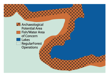
It is important that archaeological potential areas of concern are distinct from overlapping areas of concern for other values (e.g. fish habitat and water quality) since the type of operations that can occur will most likely differ.
Assessment reports completed by a licensed archaeologist engaged by a sustainable forest licence holder must meet Ontario Ministry of Culture reporting requirements. Appendix V describes how the Ontario Ministry of Culture reporting requirements should be met in the Crown land forestry context. The Ontario Ministry of Culture has identified that archaeological assessment reports may contain classified information about archaeological site values on Crown land. Therefore, a summary list of completed archaeological assessments should be filed with the forest management plan (FMP). Archaeological assessment reports represent work completed during the preparation of the forest management plan (FMP). Therefore, copies of the reports must be provided to the OMNR district and provincial cultural heritage specialist.
The OMNR determines the archaeological potential area by running a predictive model for the management unit. Appendix I gives background information about the model that is currently used by OMNR . The model was developed to replace the Ontario Ministry of Culture’s Checklist for Determining Archaeological Potential which was developed for smaller parcels of land and therefore is not well suited for the forestry context. Planning teams can choose which they prefer to use. Section 2.4.2 discusses the confirmation and verification process.
The archaeological potential area, as mapped by the archaeological potential model or the Ontario Ministry of Culture’s Checklist for Determining Archaeological Potential, is the area of concern. Areas of concern for archaeological potential areas must be distinguished from other overlapping areas of concern on the areas selected for operations maps, such as through the use of a distinct symbology (e.g. dashes or hatching as shown in Figure 10).
The following standards, guidelines, and best management practices apply to archaeological potential areas.
Figure 11: Disturbance of mineral soil within archaeological potential areas of concern
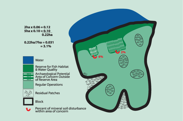
Although there is 6% mineral soil disturbance in one part of the archaeological potential area of concern, the other part of the area of concern (in the same block) only has 2%. As a weighted average this is 3.1%. Since this is less than 5% for this block the block is in compliance.
Standards
Within the archaeological potential area one of the following must occur:
- there is a reserve equivalent to the dimensions of the area of concern;
- regular operations following Ontario Ministry of Culture’s Stage 2 archaeological assessment where nothing has been found, the recommendation is that no further archaeological work is required, and the Ontario Ministry of Culture has reviewed the report;
- operations where the harvest, skidding, and renewal activities do not cause more than 5% mineral soil disturbance (on a weighted average basis) within the harvested portion of the archaeological potential area of concern within the block, as shown in Figure 11; and/or,
- for salvage operations within blowdown areas, the mineral soil disturbance is allowed to exceed 5% within the area of concern due to the previous disturbance of mineral soil by uprooted root mats on the site as shown in Figure 12.
- The FMP or compliance plan must state that “if the protection measures for an area of archaeological potential are not complied with, operations must immediately cease within the area of concern, and a Stage 2 archaeological assessment per Ontario Ministry of Culture’s current standards and guidelines for consultant archaeologists shall occur.”
- Use and maintenance of existing roads (i.e. previously disturbed right of ways) do not represent a new disturbance and therefore do not require archaeological assessment.
- All new primary and branch roads, water crossings, and landings identified in archaeological potential areas require an archaeological assessment prior to construction.
Figure 12: Forest blowdown
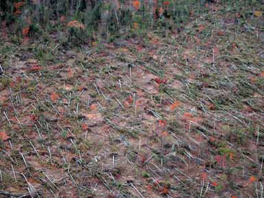
Forest areas that have had blowdown typically have many root mats lying perpendicular to the ground. Therefore a lot of mineral soil disturbance occurred prior to forest operations.
Guidelines
Harvest and skid trails, renewal and tending
Harvest operations result in varying levels of mineral soil disturbance; however, it is expected that most operations in archaeological potential areas can be conducted without causing mineral soil disturbance. Factors affecting mineral soil disturbance include season of harvest, harvest method, logging method, soil strength, slope, and operator skill.
The design of the harvest block is integral to achieving the goal of minimizing soil disturbance. The operational prescription should identify the requirement to limit skid trails within the area of concern, and to ensure that skid trails avoid areas where mineral soil disturbance might result. Areas to avoid having skid trails include areas of weaker soil, steep slopes, and low wet areas.
The following types of operations usually would meet the criterion of less than 5% mineral soil disturbance:
- winter harvest on frozen ground (i.e. frozen to >20cm);
- site preparation to align slash and/or expose (but not disturb) mineral soil; and
- tree planting, aerial seeding, and tending with herbicides.
Operational roads
Situations where operational roads can be constructed with no mineral soil disturbance might include:
- winter roads and landings constructed over packed snow and when the ground is frozen >20cm;
- water crossings constructed using snow, ice or a temporary bridge which do not require grubbing, filling or ditching, and only used while the ground is frozen >20cm
- minor alterations to the water course for culvert placement (e.g. removing a rock); and
- water crossings constructed using temporary bridges without in-ground footings. In winter, this provision applies to roads with approaches constructed using packed snow on frozen ground (>20cm). For other seasons, this provision applies to roads with approaches constructed using less than 2 metres of fill; the fill must be placed over geotextile, corduroy or brush mats; and there must be no grubbing or ditching.
Figure 13: Skid trails
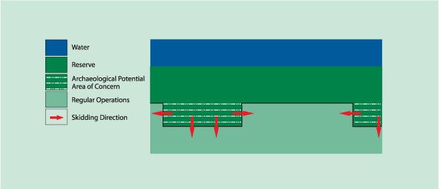
Best management practices
- When an archaeological assessment is required, only that part of the potential archaeological potential area where mineral soil disturbance might occur needs to be assessed;
- Aboriginal community member(s) should be invited to participate in archaeological assessments. A copy of the report should also be submitted to those Aboriginal communities that have an interest in the site;
- If an archaeological assessment clears an area for normal operations, then the Aboriginal community(s) that have indicated interest in the general area should be checked with to ensure there are not any historical Aboriginal values in the specific area of concern;
- In blowdown salvage harvest operations upended root mats should be put back onto the ground in order to retain the archaeological context; and
- Mapped archaeological potential areas that do not meet the assumptions of the modelling (e.g. beaver ponds and steep slopes) when they are visited in the field may change to regular operations. These areas should be documented and provided to the provincial cultural heritage specialist to support future improvements to modelling.
Figure 14: Cultural heritage landscape example
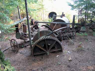
The equipment is an alligator wreck. Alligators were side- wheel, flat-bottomed steam tugs that pulled large log rafts across lakes. Using a cable and its powerful winch the tug could pull itself across a portage onto the next lake. The site would be protected in accordance with the cultural heritage landscape point feature requirements.
3.4 Cultural heritage landscapes
For the purpose of this Guide, the cultural heritage landscape values class is sub- divided. These sub-divisions are points and lines & polygons. Some point values will require protection of the local context that might include the surrounding landscape or an associated linear or polygon cultural heritage feature. For example, a cluster of buildings or wrecks might be treated collectively as a small polygon cultural heritage landscape.
3.4.1 Cultural heritage landscapes –Point features
Structural remains include features such as buildings, bridges, docks, and dams, while wrecks include old wrecked or abandoned vehicles and machines such as what is shown in Figures 14 and 15. Large artifacts such as mining equipment or abandoned vehicles (railway equipment, aircraft, boats, barges, early harvesting equipment, automobiles, and trucks) are sometimes present. The decision to protect these as cultural heritage landscape features or to remove them to an alternate location should be made in consultation with the Ontario Ministry of Culture.
It must be recognized that some cultural heritage point values, such as farm buildings or rivers modified for log drives, can signal that a larger cultural heritage polygon value is present. In the example of farm buildings, they might be nested within a recognizable pattern of fields and fences, while the modified river might be associated with a dam, a shoreline logging camp, or an early sawmill. Protection of cultural landscape polygon values should be based on a sound understanding of the key characteristics of the value. Built heritage can be defined as one or more significant buildings, structures, monuments, installations, or remains associated with architectural, cultural, social, political, economic, or military history and identified as being important to a community. Significant built heritage resources must be valued for the important contribution they make to the understanding of the history of a place, an event, or a people. An inventory mapping of properties that contain significant built heritage resources can be compiled by local, provincial, or federal jurisdictions.
Figure 15: Examples of cultural heritage landscape structures
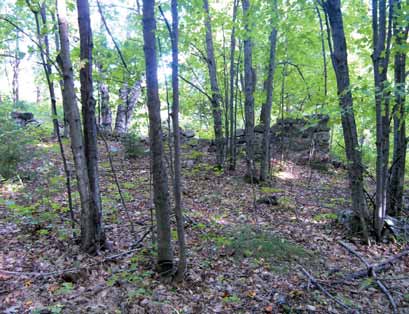
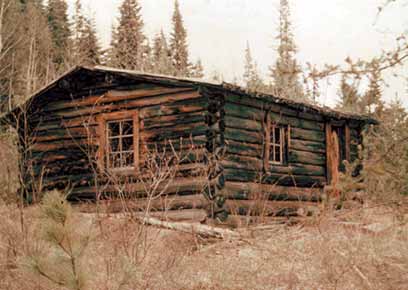
Here are examples of two cultural heritage landscape point values : an overgrown barn foundation and a former forest ranger cabin. Each of these structures would require a minimum 10 metre reserve measured from the outside walls.
The Ontario Ministry of Culture cautions against the demolition of built heritage values. They are most concerned with the destruction of a built heritage value, but also façadism (the removal of the heritage property and interior fabric of a building and retention of all of part of its façade), moving or relocation, dismantling and reassembly, and salvage of individual components. Due to the nature of forestry operations a built heritage feature can be protected by being avoided and having a reserve put around it. If circumstances arose that caused some harmful effects to a built heritage feature then the Ontario Ministry of Culture built heritage experts should be contacted.
The following standards, guideline, and best management practices apply to cultural heritage landscapes, point values.
Standards
- Protection of known values will be in the form of a reserve unless:
- the value is fully documented in a manner that conforms to the professional standards of a qualified individual; and
- any associated archaeological concerns have been addressed through the completion of the appropriate stage of archaeological assessment, and the Ontario Ministry of Culture has reviewed the report.
- Reserves for structural remains, must be established by encircling all associated remains and features with a minimum 10 metre reserve. Reserves for wrecks must be a minimum 10 metres from edges of the wreck.
Guideline
- Sites identified as having greater cultural heritage value or interest, or with potential for associated archaeological remains, will require protection measure(s) specific to that value.
Best management practices
- If the value has been identified by an individual or group, that individual or group should be invited to participate in the development of the protection measure(s); and
- The reserve dimensions should be increased when there is an identified risk of site disturbance due to the increased visibility of and access to the site area during and after forest operations.
3.4.2 Cultural heritage landscapes: Line and polygon features
Cultural heritage landscapes include physical features and patterns resulting from the intentional or traditional human use of the land. Planning of operations needs to consider the protection of both the physical features and the patterning.
Abandoned roads or railways may be documented and then reused. By documenting things like the alignment, surface treatment, edge, grade, materials, and infrastructure and condition of the linear feature this information can be preserved. Reuse of these alignments might actually provide the best protection of the landscape patterns of the earlier use. At the same time, it is important to understand that the presence of these types of features indicates a potential for associated structural heritage or archaeological values to be present in adjacent areas. In a similar fashion, many polygon features can be protected by planning operations to ensure that the pattern created by past use of the land is preserved while protecting areas with reserves where structural or unique landscape features are known or can reasonably be expected to be present.
For protection measure(s) to be effective, additional detailed planning in operational layout and scheduling might be necessary. It is important to watch while operations are proceeding for any new values that may become apparent. Generally, cultural heritage landscape values can be protected through modified operations rather than engaging a specialist.
The following standards, guidelines, and best management practices apply to linear and polygon cultural heritage landscape values.
Standards
- For cultural heritage landscape polygon values, the mapped area is the minimum for the area of concern (e.g. including the 10m reserve around buildings) as shown in Figure 16.
- For abandoned roads and railways:
- documentation and mapping of the feature is sufficient;
- the linear features may be reused (this protects the landscape pattern); and
- if you are aware of any other cultural heritage values along it, they must be protected.
- Renewal and tending operations for cultural heritage landscape polygon values can only be prescribed:
- in areas where no structural remains or associated archaeological values are anticipated; or
- where a study by a qualified individual has concluded that no additional cultural heritage landscape point values are present.
- Traditional travel routes across lakes or on rivers do not require the protection of the adjacent shoreline.
Figure 16: Example of cultural heritage landscape polygon value area of concern
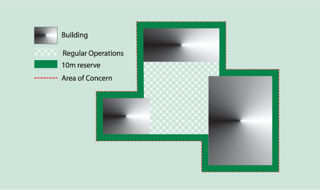
Figure 17: Cultural heritage trail
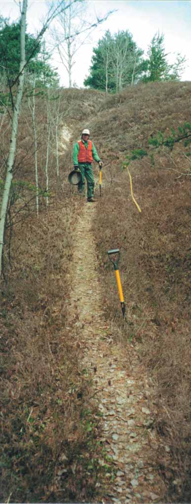
Some cultural heritage trails are ancient summer and winter pathways established by Aboriginal peoples for overland travel and canoe portaging hundreds and in some cases thousands of years ago. In the Temagami area these traditional travel routes are called Nastawgan trails.This trail is in a remote area south of Shining Tree, over the height of land at the headwaters between the Vermilion 40 River and the Wanapitei River.
Guidelines
- Protection measures for operations must consider:
- the scale of the cultural heritage landscape features and their expression on the landscape;
- the extent of the feature relative to the areas of operation;
- operation layout; and
- operator skill and familiarity with the value and protection measure(s).
- When the key defining elements of the value are visible on the ground or on aerial photography, use this information to create protection measure(s). If the planning team is not sure what the protection
- measure(s) should be, then they must consult with the Ontario Ministry of Culture and/or others who might have more information.
- For trails, portages, and other traditional travel corridors, the value plus an appropriate buffer to protect the context of the cultural feature is the area of concern. Figure 17 shows an example of a trail.
- For cultural heritage landscape polygon values possible protection measures include:
- regular operations where the proposed operations will not compromise the cultural heritage landscape pattern created by the earlier cultural use of the land; and
- modified harvest to protect the physical context or associated landscape pattern of the value.
- Operations must be laid out to conform to the general pattern of the cultural heritage landscape wherever possible (i.e. operate within fence lines of former agricultural areas).
- The number of new roads must be minimized and their layout must conform to the general patterns of the cultural heritage landscape feature to protect the landscape level pattern of the value.
- If new roads are proposed to cross linear cultural heritage landscape
- values, such as the old stone fence found in Figure 18, the crossing must be approximately perpendicular and with the area of disturbance resulting from the intersection of the road and value minimized.
- When an existing alignment is used for a new road, any existing bridges, or visible evidence or earlier structures, such as the dam shown in
- Figure 19 and cribs and foundations, must be documented.
For some features a narrower reserve but an additional area of modified operations (e.g. partial harvest) may be an appropriate prescription.
For example, a portage, trail or farmstead might have a reserve and a partialharvest zone around the reserve.
Figure 18: Old stone fence
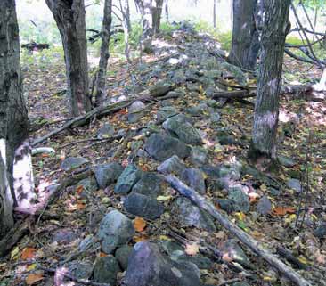
Forest operations in this area can occur up to the boundaries of the old fence, but not cross it unless absolutely necessary.
Figure 19: Timber dam remnants
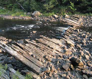
Best management practices
- If the value has been identified by an individual or group, then that individual or group should be consulted in the development of the protection measure(s).
- In some cases it might be appropriate to engage a qualified individual to identify or evaluate the principal components of a value, and to determine the location and extent of any point values within the landscape requiring protection.
Figure 20: Culturally modified tree
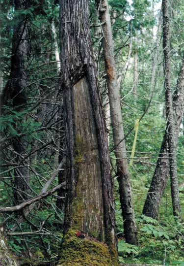
The picture is an example of a tree used by Aboriginal people for planks for building. These trees have been found in a number of locations within Northeastern Ontario.
3.5 Historical Aboriginal values
Representatives of participating Aboriginal communities play a critical role in ensuring that historical Aboriginal values are identified for the planning process. Figure 20 is an example of what some Aboriginal communities might identify as an historical Aboriginal Value. On-going discussions between the planning team and the participating communities will contribute to the development of appropriate protection measures and ensure that classified information is protected.
Protection measures should be sensitive to the fact that many values are nested or have a high reliance on context within the landscape for their cultural meaning. For example, an area of spiritual value might be positioned to take advantage of a viewscape or the sound of a waterfall or rapid. The principal components inherent to the value will determine whether the protection measure(s) should be a reserve, seasonal restrictions on operations, proper planning of road locations, modified operations, and/or some other approach.
Examples of modified operations determined through discussion could include:
- seasonal restrictions to reduce noise and traffic in a spiritual or ceremonial area;
- protection of viewscapes or adjacent forest cover for spiritual locations;
- extended return periods for strip clearcuts to ensure tree cover; and
- road decommissioning to limit access to the historical Aboriginal value.
When values provided by Aboriginal communities are stored in a data base these values must be identified as Aboriginal values to prevent inadvertently removing a value which also belongs to another value class and is later believed to be non-existent.
For values that have been identified, but which cannot be verified in the field, additional information must be requested from the qualified individual on the location and characteristics of the value.
This might include a request to participate in a field visit to assist in prescription layout. If the field visit fails to locate the value, then the value may be removed or another protection measure(s) determined for the general location of the value through discussion with the participating Aboriginal community.
Aboriginal community(s), as identified during the FMP process, will be invited to discuss the annual work schedule operations for the coming year, in order to identify new values. Completion of an Ontario Ministry of Culture archaeological assessment does not remove existing historical Aboriginal values.
The following standards, guideline and best management practices apply to historical Aboriginal values.
Standards
- Member(s) of the planning team will work with the qualified individual to help determine the protection appropriate for that value.
- Concerns about changes in the accessibility of the value must be addressed.
- The FMP or compliance plan must state that “if the protection measure(s) for an historical Aboriginal value are not complied with, operations must immediately cease within the area of concern, and the appropriate Aboriginal community must be contacted to determine if any damage can be mitigated.”
Guideline
- Historical Aboriginal values will be protected by an area of concern, the size of which will be determined on a case by case basis.
Best management practices
- Prior to operations, the qualified individual should be invited to assist in marking or verifying the marked area of concern boundaries to ensure that the boundaries are accurate.
- When discussing protection measures for historical Aboriginal values it might be helpful to look at the protection of similar values on the management unit or on adjacent units where discussions have occurred.
- Consensus between the planning team and the Aboriginal community is the preferred method for deciding on the protection measure(s) for the area of concern.
- It may be helpful to document the discussions that led to the approved protection measure(s).
- The annual work schedule should be made available to Aboriginal communities so that any additional values can be identified and protected.
3.6 Cemeteries
Cemeteries must be reported to the Registrar of Cemeteries to ensure compliance with the Cemeteries Act. Note that the Cemeteries Act will soon be replaced by the revised Funeral, Burial and Cremation Services Act. When the Registrar of Cemeteries is contacted about previously unknown cemeteries (whether they were reported to the OMNR or following a police investigation of human remains where the site was determined not to be of forensic interest) the Registrar of Cemeteries may:
- direct that an investigation be undertaken to determine, among other things, the boundaries, the cultural origin and cultural affiliation of the site; and/or
- make a formal declaration according to the Cemeteries Act pertaining to the type of burial site or cemetery; and/or
- give direction as to how wide the reserve around the cemetery must be.
When the Registrar of Cemeteries does not direct that an investigation be undertaken or only provides a recommendation to the width of the reserve, a site investigation may still be undertaken to establish the extent of the cemetery in order to better place the reserve boundary. With the consent of the Registrar of Cemeteries, a qualified individual may also conduct an investigation to identify the cultural origin and association of the cemetery.
The following standards apply to cemeteries.
Standards
- Cemeteries must be protected with a reserve.
- If the Registrar of Cemeteries gives direction on the width of the reserve, this direction must be followed at a minimum.
- Protection measures must include the protection of cemetery markers as well as the land in which the interments are located.
3.7 Discovery of cultural heritage values during forest operations
Occasionally, despite best efforts during FMP preparation to determine locations of cultural heritage values and archaeological potential areas, a cultural heritage value may be found while forest operations are proceeding. If a cultural heritage value is discovered during operations (e.g. an arrowhead, cemetery, or old logging camp) then operations must immediately stop and the district OMNR staff will be contacted as per the Forest Information Manual. The value class of the discovery will determine who of the following will be contacted: Ontario Ministry of Culture staff, the local Aboriginal community, Registrar of Cemeteries, and/or the provincial cultural heritage specialist. When the class of cultural heritage value is established, the appropriate protection measure(s) will be applied.
When human remains are discovered, work at the site must be suspended and the police notified. It is also appropriate to notify the OMNR district staff. The police will investigate the report to determine if the human remains are of forensic interest or represent a burial site as defined by the Cemeteries Act. All involved parties must act to safeguard the location until the police attend the site, and to limit media contact or display. OMNR’s provincial cultural heritage specialist can provide a list of best practices described in the Cemeteries Act to help the involved parties understand their responsibilities.
3.8 Non-compliance remedies
Since a FMP states what forest operations may occur and all operating standards, any non-compliance with the FMP may result in a remedy ranging from a warning to enforcement action such as charges. The application of a remedy will be based on guidelines set out in the Forest Compliance Handbook. In addition to Crown Forest Sustainability Act remedies, non-compliance pertaining to cultural heritage values may also induce further requirements prescribed by other legislation including the Ontario Heritage Act, the Cemeteries Act, and/or mitigation or repairs identified by an Aboriginal community. Therefore, other individuals may need to be involved if a non-compliance situation occurs concerning a cultural heritage value. The following four situations highlight when additional expertise, beyond what is prescribed by the Crown Forest Sustainability Act, must also be invited to assess possible damage to a cultural heritage value. Immediately upon recognizing that non-compliance has occurred operations must cease within the area in question and a compliance inquiry will take place per the Forest Operations Compliance Handbook or its replacement.
- Archaeological sites are protected under the terms of the Ontario Heritage Act. That Act requires anyone carrying out fieldwork or altering (which includes damage from forest operations) a known archaeological site must be licenced under the Ontario Heritage Act. Violations of the Act are subject to penalty. Therefore, the Ontario Ministry of Culture regional archaeologist shall be contacted immediately in such situations. Charges under the Ontario Heritage Act are usually laid by the Ontario Provincial Police.
- When compliance inspections of an archaeological potential area of concern determine mineral soil disturbance in excess of 5% as described in Section 3.3, the sustainable forest licence holder shall immediately arrange for a Ontario Ministry of Culture archaeological assessment to be conducted. The results of the archaeological assessment will be sent to the Ontario Ministry of Culture and OMNR.
- If there is non-compliance with a protection measure(s) for a historical Aboriginal Value then the appropriate Aboriginal community must be contacted to determine if damage can be mitigated.
- Cemeteries are protected under the terms of the Cemeteries Act. Compliance issues regarding cemeteries must be referred to the Registrar of Cemeteries for direction. Offences and penalties under the Cemeteries Act are described in Section 79 of the Act. Penalties may include fines as well as restitution.
4.0 Future development and research needs
As required by Condition 38(c) of Declaration Order MNR-71 regarding MNR’s Class Environmental Assessment Approval for Forest Management on Crown Lands in Ontario, forest management guides must be reviewed within five years of approval, and thereafter at least every five years. This section identifies a number of items that are recommended for further attention during the next five years. The information and insight obtained is intended to assist during the next scheduled review of this Guide. Also, information gathered as a result of new research and implementation experience with this Guide will assist in considering further need for revisions to this Guide. Ontario Ministry of Natural Resources (OMNR) will provide training on this Guide. Development of training materials for field staff to help recognize cultural heritage sites is recommended.
4.1 Historical Aboriginal values
Recognizing and attempting to resolve issues and clarifying processes described in this Guide will be important, but might also be outside the scope of forest management planning. Among the more important issues to be addressed are:
- Aboriginal community capacity relative to funding and community expertise to participate in values collection;
- Aboriginal community concerns regarding data sensitivity and distribution;
- Aboriginal community concerns over multiple agency values requests;
- Aboriginal cultural awareness of OMNR and forest industry staff; and
- Aboriginal community understanding of the forest management planning process.
- Improvement to the implementation of the forest management planning process as it relates to historical Aboriginal values includes:
- incorporating historical Aboriginal values and community knowledge into the archaeological potential area modelling;
- increased opportunity for Aboriginal communities to review and comment on cultural heritage values data; and
- improved understanding of the sensitivity of historical Aboriginal values
- information and developing responsive planning processes and protection measures.
4.2 Effectiveness monitoring
As required by Condition 38(f) in the Declaration Order MNR-71 regarding MNR’s Class Environmental Assessment Approval for Forest Management on Crown Lands in Ontario, this section describes the approach to be undertaken to monitor the effectiveness of the Guide.
Generally, the Guide revision team considered the questions and uncertainties raised during the preparation of the Guide and has proposed an approach to effectiveness monitoring that focuses on the intent of the protection measures described in this Guide. There are three areas that are recommended to be examined.
Wind firmness, survival, and non-disturbance of reserves:
In order for a reserve to be effective in protecting the value, it is important that the integrity of the reserve remain until the surrounding forest has regenerated. A live and intact reserve meets this objective. There will be unusual events (e.g. windstorms) that may cause changes to some reserves, but it should not be the normal situation. Information on windfirmness of standing reserves would be helpful in future considerations of the next version of this Guide.
Archaeological potential areas provide appropriate protection:
More work needs to occur to determine the threshold of acceptable mineral soil exposure and/or what forestry operations are acceptable within archaeological potential areas. It is important to allow normal forestry operations and/or establish mitigation measures which will allow forestry operations without damage to artifacts. Ontario Ministry of Culture’s standards and guidelines for consultant archaeologists play an integral role as to how the forest industry is affected by archaeological assessment. Information on practical mitigation measures would be beneficial in future revisions of this Guide.
Objectives met by historical Aboriginal values/cultural heritage landscape values prescription:
Historical Aboriginal values and most cultural heritage landscape values are not given a specific reserve in this Guide, but rather left to be determined based on an understanding of the value. A qualified individual determines the protection measure(s) in conjunction with the planning team. A review of this process should be undertaken to better assess how well the protection measure(s) meet their intended purpose. This review may assist in future versions of the guide by providing more specific direction or best practices advice on protecting these values, if or where appropriate. Information from an effectiveness monitoring program which focuses on these three areas will assist the authors of future versions of this Guide.
4.3 Archaeological potential area modelling
During the last stages of the preparation of this Guide, the Heritage Assessment Tool, which is the model currently used by the Ontario Ministry of Natural Resources to identify archaeological potential areas, was reviewed by consultants and OMNR staff. Based on the recommendations the model was improved which will result in increased efficiencies as the Guide is implemented during forest management planning. Periodic review of the model should continue in the future to make improvements through measures such as the integration of improved databases. Some of the improvements to be considered in the modelling, depending on availability, would include the application of:
- Light Detection and Ranging (lidar) data;
- Northern Ontario Engineering Geological Terrain Study (NOEGTS) coverages
- (focusing on best available terrain and soils information);
- forest resource inventory;
- information about modifications to waterways (e.g. beaver ponds, dams);
- integration of air photography high-resolution satellite imagery into the prepared dataset (layer/coverage in the model and not a manual exercise);
- improved and verified archaeological site location information (e.g. categorizing archaeological sites into chronological and site type categories);
- improved calibrations (e.g. using results of Ontario Ministry of Culture Stage 2 archaeological assessment); and
- archaeological potential areas that have been removed as the result of a Stage 2 archaeological assessment (e.g. using the information gained about where sites are not being identified).
In addition to these considerations, maintaining a close relationship between the FMP team and Heritage Assessment Tool operator is also important to the process. This will ensure that additional information, perhaps not available to the operator that could contribute to output refinement, can be made available. In addition, this working relationship will also be fundamental to the protection and management of archaeological potential areas.
Because the Heritage Assessment Tool uses those datasets with information that correspond to modelling of pre-contact archaeological sites, it was recommended that the moose, beaver, and deer capacity coverages be removed from the modelling process. Due to the variation of vegetation and drainages across the landscape over time, this information may be obsolete. As a result, those information sources deemed most significant for modelling the past use of the landscape includes:
- lakes;
- streams;
- topography;
- soil texture;
- drainages;
- forest resource inventory;
- information on productive fisheries and abundant gaming areas; and
- historic information and air photography.
As well, the Heritage Assessment Tool operator may also benefit from datasets that provide information on navigable waterways and areas avoided for settlement (e.g. wetlands, steep slopes, poor soil drainage, high elevation above water).
4.4 Cultural heritage values inventory
As noted in Section 2.1, a range of data sources are available for the identification of cultural heritage values to be protected in forest management planning. During the implementation of this Guide, it is expected that new data will be added.
Identification of new data might require:
- review and change, as necessary, data classes and categories currently defined in OMNR’s Natural Resource Values Information System;
- adding new data sources to be used in identifying values; and
- add unclassified data to Natural Resource Values
Information System as data become available. It is expected that improvements to the database and information systems will be ongoing and will be a consideration in the next review of this guide.
Appendix I: Archaeological potential area modelling
Overview
The archaeological potential area modelling for forest management planning is developed using the Heritage Assessment Tool, which uses a series of scripts, to determine the geographical areas, based on statistical testing and operator experience.
The operator is either the provincial cultural heritage specialist or an archaeologist with similar expertise, hired by OMNR to assist the provincial cultural heritage specialist with archaeological potential modelling.
Archaeological potential modelling using the Heritage Assessment Tool can be described as a 3-step process:
- Pre-processing
- Calibration
- Post-processing of data
1. Pre-processing
Pre-processing is, for the most part, applied by the Peterborough Geomatics Service Centre in the preparation of the datasets used in the modelling. This data is then provided in a ready-to-use format, as a prepared view to be used in an ArcView project (also see Configuring the Data).
2. Calibration
The calibration process, which follows the pre-processing of the data, allows the operator to calibrate individual layers based on landscape characteristics. This involves a weighted value process whereby weights, and buffer distances are combined to provide a weighted value (also see Calibration).
3. Post-processing
Finally, the post-processing feature is used to generate the comparative distribution of the values that are statistically evaluated, where the operator can examine the landscape value of the archaeological site for the different layers used (also see Setting Archaeological Potential).
Data
The Heritage Assessment Tool uses both raster and vector datasets in the archaeological potential modelling. The vector data are the shapefiles while the 54 raster data refer to the grids used. The shapefiles and grids provided by the Provincial Geomatics Information Centre are in NAD 83 and include the following:
Grids:
- 20m Digital Elevation Model
- 20m Quaternary Geology, Ministry of Northern Development & Mines
- 20m Quaternary Geology Age
- 20m Bedrock Geology, MNDM
- 20m Surficial Geology, Ontario Forest Research Institute
- 20m Ontario Land Inventory Site Moisture
- 20m Ontario Land Inventory Soil Texture
- 20m Ontario Land Inventory Parent Material
- 20m Ontario Land Inventory Moose Capability
- 20m Ontario Land Inventory Beaver Capability
- 20m Ontario Land Inventory Deer Capability
Note: 20m is the ground area represented by each grid cell.
Shapefiles:
- Natural Resources and Values Information System Waterbodies (Lakes and Rivers)
- Natural Resources and Values Information System Waterbodies (Wetlands) Corrected Natural Resources and Values Information System Waterflow – Strahler Stream Ordered
- Natural Resources and Values Information System Rapids/Falls Points and Lines
- Natural Resources and Values Information System Landownership Indian Reserves
- Ministry of Northern Development and Mines Quaternary Geology Lines
- Natural Resources and Values Information System Railway Lines Borden Units (i.e. locations of archaeological sites)
Other data used include: Ontario Ministry of Culture’s registered archaeological sites, Forest Resource Inventories, Northern Ontario Engineering Geological Terrain Study (NOEGTS) datasets, as well as Light Detection and Ranging (lidar)-based 5-m Digital Elevation Models.
Configuring the data
The configuration data is simply the preparation of the datasets to be used for archaeological potential modelling using the Heritage Assessment Tool. Not all datasets will necessarily be used for the archaeological potential modelling (e.g. Ontario Land Inventory Deer Capability), and this is the step where such refinements are made. Configuration of the data involves basically a series of automated scripts used by Peterborough Geomatics Service Centre to clip the various available datasets to a forest management unit. The prepared view is then provided to the operator who assembles these scripts into an ArcView project prior to calibrating the model.
Calibration
The calibration process allows the operator to calibrate individual data layers based on landscape characteristics, involving a weighted value approach. The operator is able to place a weight on a selected script based on the statistical strength of the feature that was derived from testing the fit between a theoretical frequency distribution and a frequency distribution of observed data.
For example, proximity to waterbodies will have a greater weight in the modelling for pre-contact settlements, so that at a distance of 0-100m from the water, the weighted value (WV) will be higher than at distances further from the water. For certain scripts, such as slope, a negative value can be used to reduce the possibility of capturing areas improbable of archaeological potential. The following is an example of slope weights and values for the 2008 Red Lake Forest Management Plan.
| Theme | Degrees | Weight | Value | WV |
|---|---|---|---|---|
| Slope | 0-5° | 3 | 4 | 12 |
| Slope | 5-10° | 3 | 3 | 9 |
| Slope | 10-25° | 3 | 0 | 0 |
| Slope | 25-50° | 3 | 0 | 0 |
| Slope | 50-75° | 3 | -2 | -6 |
| Slope | 75-90° | 3 | -3 | -9 |
Setting archeological potential
To set the archaeological potential, the Heritage Assessment Tool uses the Ontario Ministry of Culture registered archaeological site locations and incorporates this information into the ArcView project. The known archaeological site locations provided by Ontario Ministry of Culture help determine the characteristics of the landscape that have greater archaeological potential. Based on this determination, the weights and values are established for calibrating the Heritage Assessment Tool to generate an initial output. Using this output in a statistical analysis, the distribution of sites across the landscape is examined to determine whether the initial weights and values are suitable. Quite often, multiple runs are required prior to attaining a successful output that is statistically sound. The successful output will show a lower frequency of land cells being captured and a higher frequency of archaeological sites.
Confirming archaeological potential
Confirming the output from the Heritage Assessment Tool preliminary maps involves the following steps.
- Modelling results are not treated as known values until the OMNR provincial cultural heritage specialist has conducted further investigation or analysis. This is achieved by re-examining the model assumptions, the resulting output and refining archaeological potential areas requiring protection. This might involve a manual cleanup of the map and/or multiple runs of the model and results in the production of a second map showing archaeological potential areas which will be made available to the planning team.
- The planning team will review this second map to identify areas where local knowledge can provide additional information. Planning teams identify where potential areas could be further reduced, including their rationale and supporting information (e.g. updated forest resource inventory showing alder).
- The final archaeological potential area map will be produced once planning teams have had the opportunity to review the potential map. This final map reflects where the OMNR provincial cultural heritage specialist concurs with the proposed changes to the archaeological potential areas. Normally, the review period is 30 days from receipt of the initial map. If the archaeological potential areas are accepted as mapped, the second map will constitute the final values map. The final archaeological potential areas will be the areas to be used for area of concern planning.
- If it is observed in the field that the features do not match the data used in the predictive model, or the assumptions of the model, then these values will be refined through communication between the planning team and the provincial cultural heritage specialist. These assumptions address landscape values not archaeological sites. The intention of this step is to ensure that areas identified as archaeological potential match the modelling assumptions defined in the calibration of the final runs.
The process of confirmation of archaeological potential areas is concluded when these steps have been completed.
Appendix II: Integration with forest management planning
The protection of cultural heritage values from forest management activities is part of the forest management planning process. This section is intended to help planning teams understand at what stages of the forest management planning process steps need to be taken in order to fulfill the intent of this Guide. The Forest Management Planning Manual for Ontario’s Crown Forests (June 2004) or its successor describes the forest management planning and amendment process in detail.
Forest management planning schedule
The following is an overview of the stages for the two phases of the ten year forest management plan based on the 2004 Forest Management Planning Manual. The remainder of this appendix discusses each of these stages in more detail regarding cultural heritage protection.
Stage of the Forest Management Planning Manual: Phase one
- Stage 1: Organizing for planning-
- Item to be completed to fulfill protection of aitural heritage values obligations
- Contact cultural heritage reviewers and advisors and add to the mail list and/or terms of reference as necessary;
- send completed planning inventory and locally known cultural heritage sites to provincial cultural heritage specialist (as allowed by any data loan agreements);
- provincial cultural heritage specialist ensures archaeological potential area modelling is completed and sent to planning teams;
- contact Ontario Ministry of Culture for registered archaeological sites data;
- contact Registrar of Cemeteries for cemeteries located on Crown land within the management unit;
- assess OMNR values database for gaps or poor information; steps required to correct these gaps identified; and
- contact Aboriginal communities to discuss participation in updating Aboriginal Background Information Reports, including the values maps.
- Item to be completed to fulfill protection of aitural heritage values obligations
- Stage 2: Proposed long-term management direction
- Item to be completed to fulfill protection of aitural heritage values obligations
- prepare draft Aboriginal Background Information Report(s), including values maps; and
- ensure expected amount of forest in reserves due to cultural heritage values protection is reflected In wood supply modelling.*
- Item to be completed to fulfill protection of aitural heritage values obligations
- Stage 3: Planning of proposed operations
- Stage 4: Preparation, submission and review of draft FMP
- Item to be completed to fulfill protection of aitural heritage values obligations
- ensure final Report on Protection of Identified Aboriginal Values is written*; and
- ensure draft forest management plan is reviewed, ensuring cultural heritage values are properly identified and protection requirementsaddressed.
- Item to be completed to fulfill protection of aitural heritage values obligations
- Stage 5: Revision and approval of the FMP
- Item to be completed to fulfill protection of aitural heritage values obligations
- ensure required alterations regarding cultural heritage have been completed prior to forest management plan approval.
- Item to be completed to fulfill protection of aitural heritage values obligations
Stage of the Forest Management Planning Manual: Phase two
- Stage one: Planning of proposed operations
- Item to be completed to fulfill protection of aitural heritage values obligations
- discuss with provincial cultural heritage specialist whether necessary to rerun model to determine archaeological potential areas. Do so if needed;
- make plan reviewers and cultural heritage advisors aware of preparation for second five year period of the forest management plan;
- update mail list and terms of reference accordingly;
- check values maps that updates have been Included*;
- contact Aboriginal communities to discuss participation in updating Aboriginal Background Information Reports, Including the values maps*; and
- contact Ontario Ministry of Culture for registered archaeological site data.
- Item to be completed to fulfill protection of aitural heritage values obligations
- Stage two: Preparation, submission and review of the draft planned operations
- Item to be completed to fulfill protection of aitural heritage values obligations
- ensure existing protection measures are still valid. Change as required;
- do area of concern planning for any new value types*
- do roads planning as required; and
- review draft forest management plan ensuring cultural heritage values are properly identified and protection requirements addressed.
- Item to be completed to fulfill protection of aitural heritage values obligations
- Stage three: Revision and Approval of Planned Operations
- Item to be completed to fulfill protection of aitural heritage values obligations
- ensure required alterations regarding cultural heritage have been completed prior to forest management plan approval.
- Item to be completed to fulfill protection of aitural heritage values obligations
- Forest Management Plan implementation
- Item to be completed to fulfill protection of aitural heritage values obligations
- General
- ensure that values requiring development of specific protection measures at the annual work schedule stage are complete prior to forest management activities in indicated area*
- ensure that all amendments consider possible effects on known cultural heritage values;* and
- ensure that compliance inspections include assessment of the implementation of cultural heritage protection.*
- General
- Item to be completed to fulfill protection of aitural heritage values obligations
*These items are not discussed in any more detail in this appendix. The Forest Management Planning Manual for Ontario’s Crown Forests (June 2004) should be consulted for a more detailed explanation.
Forest management planning manual
Phase 1 –stage 1 –organizing for planning
Step 1: Notification
Data providers and others who might be asked to provide background cultural heritage information or planning support, as well as plan reviewers or advisors need to be aware when forest management planning will commence. The OMNR district manager should provide notice prior to the start of planning. At a minimum, the following staff need to be contacted and added to the mail list:
- OMNR provincial cultural heritage specialist;
- Ontario Ministry of Culture regional archaeologist; and
- Ontario Ministry of Culture data coordinator.
The advisors are listed in the terms of reference for the forest management plan along with the portions of the plan they will provide advice and/or review.
Step 2: Update of cultural heritage information
OMNR district and head office staff assemble available values data and the planning team reviews the data for accuracy, sensitivity, and the need for special consideration in planning. This cultural heritage data are the basis for area of concern planning. The data on these maps come from several sources which the following describes in more detail.
The appropriate planning team member will request to review the Aboriginal Values map(s) and the Native or Aboriginal Background Information Report with members of the participating Aboriginal community, including:
- review history of data collection, methods and products;
- identify classified data, or data of special value to planning; and
- identify data gaps and possible effects of these gaps on planning.
This will help identify where effort can be made in the preparation of the draft and final Aboriginal Background Information Reports for the new forest management plan. Consideration also needs to be given to the Aboriginal community to develop these reports and identify what additional resources may be required.
Cultural heritage landscape data will be compiled from available sources at the OMNR district, such as those listed in Section 2. The historic data sources should be reviewed in order to:
- identify and map key historical themes in the forest management unit;
- identify and map any available cultural heritage landscape source data; and
- identify data gaps and possible effect on planning.
If a review of this data identifies gaps or shows available information is incomplete, then the planning team should determine how these concerns will be addressed in the plan. The OMNR provincial cultural heritage specialist will incorporate this data into the archaeological potential area modelling for the forest management unit.
- Once the planning inventory has been deemed complete and accurate a digital copy should be forwarded to the OMNR provincial cultural heritage specialist for use in archaeological potential area modelling. If archaeological assessments have been done for any archaeological potential areas in the current plan, then the results of these should also be forwarded to help in the calibration of the archaeological potential area modelling tool.
- Registered archaeological site data will be requested from the Ontario Ministry of Culture data coordinator. This data will be assembled and reviewed prior to use in archaeological potential area modelling. This review will include the identification of data gaps and their possible effect on planning.
Output from the modelling and other applicable datasets will be transferred to the planning team to form part of the background information available during the FMP process. Confirming and verifying the values can commence at this point in 60 planning, as discussed in Section 2.4.
Phase 1 –stage 2 –proposed long-term management direction
Step 3: Draft Aboriginal background information report(s)
At the end of this stage, there will be a draft Aboriginal Background Information Report with a values map available for each participating Aboriginal community. It is advisable to have a data loan or sharing agreement in place at this point. This agreement will direct how values data contained in the reports and maps must be treated in planning.
Phase 1 – stage 3 – planning of proposed operations
Step 4: Operational planning
Area of concern and roads planning will be done for the areas selected for operations in accordance with this Guide. As part of this planning, the planning team must determine how classified information will be treated, including how this cultural heritage data will be portrayed on planning or operations maps and in area of concern and road planning documentation.
The OMNR planning team member responsible for working with Aboriginal communities can assist the planning team and participating Aboriginal community(ies) in developing a process(es) for developing protection measures.
Phase 1 – stage 4 – preparation, submission and review of draft Forest Management Plan
Step 5: Draft plan review
Notice that the draft FMP has been submitted to OMNR for review and comment should be circulated per the terms of reference. The normal review process will be followed.
Phase 1 – stage 5 – revision and approval of the Forest Management Plan
Step 6: Final plan review
Notice that the final FMP has been submitted should be circulated per the Terms of Reference. The final plan review will ensure that items in the required list of alterations identified during the draft plan review have been addressed.
Phase 2 – stage 1 – planning of proposed operations
Step 7: Archaeological potential area modelling
Any additional modelling required for the archaeological potential areas should be completed prior to refining any proposed areas of concern within harvest blocks. All additional modelling should be completed as directed by the OMNR provincial cultural heritage specialist.
Step 8: Notification
Notification that preparation of the second five year period of the forest management plan should include those listed in Step 1, plus any other individuals that were identified by the planning team as having relevant data or a particular interest in cultural heritage protection. This notification needs to include a request to Ontario Ministry of Culture for any additional registered archaeological site information reported in the preceding five years. These contacts will be part of the mail list and the terms of reference will include those who will provide advisory and review roles for cultural heritage protection.
Phase 2 – stage 2 – preparation, submission and review of the draft planned operations
Step 9: Area of concern and roads planning
Existing cultural heritage values protection measures must be reviewed to ensure they are still valid, and whether protection measures for other categories of values need to be developed and added. Conditions for affected roads need to be determined.
Step 10: Draft plan review
Notice that the draft FMP has been submitted to OMNR for review and comment will be circulated per the terms of reference. The normal review process will be followed.
Phase 2 – stage 3 – revision and approval of planned operations
Step 11: Final plan review
Notice that the final FMP has been submitted needs to be circulated to those listed in Step 1. These individuals should identify to the OMNR contact which sections of the draft plan, if any, they wish to review. The final forest management plan will be reviewed to ensure that items in the required list of alterations identified during the draft plan review have been addressed.
Appendix III: Roles and responsibilities
The protection and stewardship of Ontario’s cultural heritage values is a provincial responsibility. In the FMP, the responsibility for ensuring that the provincial interest is addressed in planning and in operations is distributed among a number of agencies. Understanding the roles and responsibilities for cultural heritage protection can ensure that values are protected, the provincial interest is addressed, and that forest management planning and operations proceeds smoothly.
Ministry of Culture
- Agency/staff position/planning team member
- Data coordinator area of responsibility
- provide registered site data for archaeological potential area modelling; provide registered site data for area of concern planning; and data and support for cultural heritage landscape maps.
- Regional archaeologist area of responsibility
- support review of archaeological potential area modelling, cultural heritage landscape maps and protection measures; and support identification of data sources, gaps, future data needs.
- Data coordinator area of responsibility
Ministry of Natural Resources
- Agency/staff position/planning team member
- Provincial cultural heritage specialis area of responsibility
- archaeological potential area modelling; direction to planning teams on confirming and verifying values; FMP training on operational planning for cultural heritage values; and support for developing cultural heritage values protection measures.
- MNR planning team member assigned the role of Aboriginal liaison area of responsibility
- facilitate Aboriginal community participation in planning; coordinate Aboriginal Background Information Report and associated values mapping; and identification of issues relating to operational planning and discussion with participating Aboriginal communities.
- Provincial cultural heritage specialis area of responsibility
Others
- Agency/staff position/planning team member
- plan author with planning team area of responsibility
- develop appropriate area of concern prescriptions and road planning; discuss protection strategies and protection measures with participating Aboriginal communities; and ensure protection of classified information as agreed with provider.
- Local citizens committee heritage member
- Area of responsibility
- aid in the identification and collection of cultural heritage information.
- Area of responsibility
- Aboriginal planning team members(s)
- Area of responsibility
- assist in identification and collection of Aboriginal values; and support identifying values locations and mapping and in determining protection measures.
- Registrar of Cemeterie
- provide known cemetery data respond to inquiries about previously unknown cemeteries give direction regarding reserves around cemeteries
- Area of responsibility
- plan author with planning team area of responsibility
Appendix IV: Example FMP tables
These completed sample Tables FMP-14, written in accordance with direction from the Forest Management Planning Manual (2004), are for illustration purposes only. Each table is prefaced with a situation that the table is intended to apply to. Contents of the table are not generic enough to apply to individual management units. Each forest management planning team must determine protection measures and use these sample tables only as guidance when completing Table FMP-14. Section 3 must be read in order to understand the standards, guidelines, and best management practices that must be considered for each value.
Background:
This is a straightforward example of an operational prescription for a registered archaeological site when: no other values class must also be addressed, there is no indication from the Ministry of Culture or an archaeologist that the sites are significant,and there are no established boundaries. The planning team has decided to protect the classified nature of the values' information by not showing the sites and the protection measures for the site on the operations maps, rather the information will Cl only appear on maps that specific field staff will be using. In this table it is identified only as a confidential value. The same is done for all other confidential values in this FMP.
Sample #1: FMP-14 operational prescriptions for areas of concern
- Management unit name: Ever Green Forest
- Plan period: 2008 to 2018
- Phase I (Year 1- 5)
- AOC or AOC Group Identifier: CV10217
- Description of natural resource feature, land use or value: Confidential Value
- Individual or group AOC: Group
- Operational prescription: 200m reserve from site centre. No harvest, renewal,or tending activities. Marking of the reserve boundaries must not draw attention to the value.
- SGR Code:
- Source: Forest Management Guide for Cultural Heritage Values (2006) pp. 27, 29-31
- Exception:
- Objedion:
- Roads, Primary or Branch Road Crossing: n/a No new roads permitted.
Notes to guide users: Location of these values is not included on values maps and operations maps in the FMP. Locations will be available for tree markers and logging supervisors so that they may identify the area of concern boundary on the ground.
Background:
This operational prescription applies to a registered archaeologicalsite that an Aboriginal community has also identified as a historical value,and therefore, has been involved in the determination of the protection measures. This site has an established boundary indicated in the Ministry of Culture records. The Aboriginal community has explained why this site needs to have more protection than the 10m directed in this guide. The Aboriginalcommunity and the planning team have agreed that an additional reserve (25 metre radius in total) is appropriate. The planning team has decided to protect the classified nature of the values information by not showing the site on the operations maps, rather the information will only appear on maps that specific field staff will be using. In this table it is identified only as a confidential value. The same is done for all other confidential values in this FMP.
Sample #2: FMP-14 operational prescriptions for areas of concern
- Management unit name: Ever Green Forest
- Plan Period: 2008 to 2018
- Phase I (Year 1- 5)
- AOC or AOC Group Identifier: CV10367
- Description of Natural Resource Feature, Land Use or Value: Confidential Value
- Individual or Group AOC: Individual
- Operational Prescription:
- 25m reserve from established boundary of the site. No harvest, renewal,or tending activities. Marking of the reserve boundaries must not draw attention to the value. Manitou Aboriginal community willbe invited to help mark the reserve boundary. Any change in the prescription will first be discussed with Manitou Aboriginal community.
- SGR Code
- Source: Forest Management Guide for Cultural Heritage Values (2006) pp. 27-28, 29-31 and discussion with Manitou Aboriginal Community.
- Exception
- Objection
Roads:
- Primary or Branch Road Crossing: n/ No new roads permitted.
- Conditions on Operational Roads: n/a No new roads permitted.
Notes to guide users: Location of these values is not included on values maps and operations maps in the FMP. Locations will be available for tree markers and logging supervisors so that they may identify the area of concern boundary on the ground. A standard on page 43 gives the specific wording that must be put in the FMP which explains the process to follow if the protection measures are not followed.
Background:
This is the standard operational prescription for archaeological potential areas identified by the Heritage Assessment Tool. It might be decided that a future Ministry of Culture Stage 2 archaeological assessment will occur or the forest company might decide they can operate while adhering to the maximum standards for mineral soil disturbance. This information is not considered classified data and therefore,will be shown on maps and discussed in the plan.
Sample #3: FMP-14 Operational prescriptions for areas of concern
- Management unit name: Ever Green Forest
- Plan Period: 2008 to 2018
- Phase I (Year 1- 5)
- AOC or AOC group identifier: AP
- Description of Natural Resource Feature, Land Use or Value:
- Archaeological Potential Area Archaeological potential area is the area from the predictive model, as mapped.
- Individual or Group AOC: Group
- Operational Prescription:
- Within each mapped area one ofthe following will be done:
- a reserve
or - operations where the harvest, skidding, and renewal activities do not cause more than 5% mineral soil disturbance (on a weighted average basis) within the harvested portion ofthe area of concern within the block.
- skid trails will minimize the skid distance out of the area of concern and sharp corners will be avoided.
or - within blowdown areas the mineral soil disturbance (weighted average) may exceed 5% within the area of concern. Root mats are to be put back into place wherever possible.
or - if a Ministry of Culture Stage 2 archaeological assessment is completed, nothing is found and the recommendation is that no further archaeologicalworks is required and Ministry of Culture has reviewed the report Then regular operations can proceed in the assessed area.
- Copies of any archeologicalassessment reports will be provided to the MNR area forester and provincialcultural heritage specialist.
- a reserve
- SGR Code:
- Source:
- Forest Management Guide for Cultural Heritage Values (2006) pp.33-35 and FMP supplementary documentation
- Roads,
- Primary or Branch Road Crossing: Yes, refer to FMP 23
- Conditions on Operational Roads: Yes, refer to FMP 23
Notes to guide users: Roads are allowed in this area of concern under certain conditions therefore other FMP documentation is required.
Area of concern supplementary documentation and FMP-23 would reflect the following as appropriate:
primary, branch and operational roads are pennitted if the road currently exists or if a Ministry of Culture Stage 2 archaeological assessment is done and the archaeologist’s recommendations are followed. Also permitted are operational roads that must go through the area of concern and can be designed with no mineralsoil disturbance, otherwise an archaeological assessment must be completed and the reports' recommendations followed Maintenance of all existing roads is permitted. New landings require a Ministry of Culture Stage 2 archaeological assessment prior to creation. A standard on page 33 gives the specific wording that must be put in the FMP which explains the process to follow if the protection measures are not followed.
Background:
This operational prescription has been developed for a value that was identified by an Aboriginal community. A qualified individual designated by the community worked with the planning team to determine the protection measures. The planning team has complied with the terms ofthe data sharing agreement by not portraying the site in stand listings or on the operations maps. In this table it is identified only as a confidential value. The same is done for all other confidential values in this FMP.
Sample #4: FMP-14 Operational prescriptions for areas of concern
- Management unit name: Ever Green Forest
- Plan Period: 2008 to 2018
- Phase I (Year 1- 5)
- AOC or AOC Group Identifier: CV10334
- Descriptionof Natural Resource Feature, Land Use or Value: Confidential value
- Individual or Group AOC: Individual
- Operational Prescription
- Variable res erve area as identified on operations maps. Manitou Aboriginalcommunity will be invited to help mark the reserve boundary. Marking of the reserve boundaries must not draw attention to the value.
- Prior to any change in the prescription a discussion will occur with Manitou Aboriginal community.
- SGR Code
- Source:
- Discussion with Manitou Aboriginal Community and Forest Management Guide for Cultural Heritage Values (2006) pp. 27, 43 and FMP supplementary documentation.
- Exception
- Objection
- Roads:
- Primary or Branch Road Crossing: n/a No new roads permitted.
- Conditions on Operational Roads: n/a No new roads permitted.
Notes to guide users: Location of these values is not included on values maps and operations maps in the FMP. Locations will be available for tree markers and logging supervisors so that they may identify the area of concern boundary on the ground. Since there are not specific standards and guidelines giving the appropriate protection measures for this value in the guide they were developed by the planning team andarea of concern supplementary documentation was completed. A standard on page 43 gives the specific wording that must be put in the FMP which explains the process to follow if the protection measures are not followed.
Background:
This operational prescription has been developed for a cultural heritage landscape polygon value. It is an old logging camp with old machinery still on site amongst the building foundations.
Sample #4: FMP-14 Operational prescriptions for areas of concern
- Management unit name: Ever Green Forest
- Plan Period: 2008 to 2018
- Phase I (Year 1- 5)
- AOC or AOC Group Identifier: CL24681
- Description of Natural Resource Feature, Land Use or Value: Cultural Heritage Landscape Polygon
- Individual or Group AOC: Individual
- Operational Prescription: 10 metre reserve around relict machinery and foundation of buildings: Ensure harvesting in area adjacent to reserve is done so that trees, branches etc. don't fall on known values.
- SGR Code:
- Source: Forest Management Guide for Cultural Heritage Value (2006) p.37 and Dunn Historical Committee.
- Objection:
- Roads:
- Primary or Branch Road Crossing: Yes. Refer to FMP 23.
- Conditions on Operational Roads: Yes. Refer to FMP 23.
Notes to guide users: Roads are allowed in this area of concern therefore other FMP documentationis required. Area of concern supplementary documentation would reflect that the number of new roads must be they must conform to the general patterns of the culturalheritage landscape feature to the landscape levelpattern of the value.
Background:
This operational prescription applies to a cemetery using the direction from the Registrar of Cemeteries
Sample #5: FMP-14 operational prescriptions for areas of concern
- Management unit name: Ever Green Forest
- Plan Period: 2008 to 2018
- Phase I (Year 1- 5)
- AOC or AOC Group Identifier: CM
- Description of Natural Resource Feature, Land Use or Value: Cemetery
- Individual or Group AOC: Individual
- Operational Prescription: No forest management operations within 1Sm of cemetery boundary.
- SGR Code
- Source: Forest Management Guide for Cultural Heritage Values (2006) p.4 Sand the Registrar of Cemeteries.
- Exception
- Objection
- Roads:
- Primary or Branch Road Crossing: n/a No new roads permitted.
- Conditions on Operational Roads: n/a No new roads permitted.
Appendix V: Requirements for archaeological assessment reports
Archaeological fieldwork and assessment completed by a licensed archaeologist must be reported to the Ontario Ministry of Culture in the form set out in Ontario Ministry of Culture’s current standards and guidelines for consultant archaeologists. When archaeological fieldwork or assessment is conducted to meet a requirement of an area of concern prescription or road planning, it is advised that additional summary information be set apart from the main text and included in the final report. This facilitates compliance or audit reviews, and may expedite review by Ontario Ministry of Culture. It should be noted that archaeological assessment alone is not sufficient to address protection requirements for other classes of cultural heritage values. Information that should be presented in this summary includes the following.
Identification
- Forest Management Unit name and number
- Forest Management Plan year and author
- Sustainable Forest Licence holder
- Contact information for the sustainable forest licence holder (name, address, phone and email)
Purpose of assessment
- Cultural heritage value class(es) present within area of concern
- Proposed operations within area of concern
- Extent of proposed operations within area of concern (including dimensions)
- Extent of assessment (including dimensions)
- A copy of FMP-14 for the value(s) should be included as an appendix to the report
Location/h3>
- Area of concern identifier (area of concern number)
- Associated forest stand identifier
- An operational scale map, in colour, should also be included in the report
Results
- Summarize results of the assessment relative to the prescription in FMP-14
- Summary of recommendations made in the report (page reference)
- List of all cultural heritage values identified through fieldwork
- List of all archaeological sites registered/to be registered with Ontario Ministry of Culture
- If no values were identified, a statement to this effect should be made
Glossary of terms
The purpose of this glossary is to define and to explain terms which appear and are of importance in the text of this Guide. This glossary reflects how the terms are used in forest management, which might be different from other users (e.g. Aboriginal people and archaeologists). Some of these differences have been noted in the definitions. The definitions provided in this glossary have been taken fully, modified, or adapted from an already existing source, as indicated. References for these entries are abbreviated as follows:
- AITCM
- Archaeological Inventory Training for Crew Members – Workbook, Government of British Columbia, 1999
- CA
- Cemeteries Act, 1990
- EPA
- Environmental Protection Act, 1990
- FIM
- Forest Information Manual, 2001
- FMPM
- Forest Management Planning Manual, 2004
- OHA
- Ontario Heritage Act, 1990
- PPS
- Provincial Policy Statement, 2005
- Aboriginal Value
- for the purpose of this Guide, historical Aboriginal values are those which can be mapped and fit the cultural heritage definition in Section 1.2.
- Adverse Effect
- it includes: impairment of the quality of the natural environment for any use that can be made of it; injury or damage to property or plant and animal life; and/or loss of enjoyment of normal use of property. (EPA)
- Alteration
- In the sense of the Ontario Heritage Act an alteration is a change to an archaeological site in any manner such as to restore, renovate, repair, or disturb. For the purpose of this Guide, an alteration is to mitigate the disturbance of an archaeological site.
- Archaeology
- The study of humans by examining and interpreting the physical objects of the everyday lives of people in the past. (AITCM)
- Archaeologist
- A scientist professionally trained to study the human pattern through the study of past material culture. (AITCM)
- Archaeological Assessment
- A licensed archaeologist using the process described in the current Ontario Ministry of Culture’s current standards and guidelines for consultant archaeologists. Currently for forest management activities the most common assessment types are Stage 1 and Stage 2 assessments, which are done to determine and then evaluate archaeological potential areas. There are four stages in total: Stage 1 evaluates the archaeological potential of an area; Stage 2 has actual field examination; Stage 3 assesses the cultural heritage value or interest of the archaeological sites, and Stage 4 recommends how to properly unearth and move a site prior to work being done that would be detrimental to it.
- Archaeological Potential Areas
- Areas with the likelihood to contain archaeological resources. Criteria for determining archaeological potential are established by Ontario Ministry of Culture. Archaeological potential areas are confirmed through a prescribed process, such as described in the Forest Information Manual. It is verified through archaeological fieldwork undertaken in accordance with the Ontario Heritage Act.
- Archaeological Resources
- Includes artifacts, archaeological sites, and marine archaeological sites. The identification and evaluation of such resources are based on archaeological fieldwork undertaken in accordance with the Ontario Heritage Act. In forest management planning archaeological resources are referred to as archaeological values.
- Archaeological Site
- Any property that contains an artifact or any other physical evidence of past human use or activity that is of cultural heritage value or interest (OHA). See also registered archaeological site.
- Area of Concern
- A geographic area within an area of operations which is adjacent to an identified natural resource feature, land use or value that could be affected by forest management activities. (FMPM)
- Artifact
- Any object, material or substance that is made, modified, used, deposited or affected by human action and is of cultural heritage value or interest. (OHA) An object or product of cultural significance that has been modified by human activity or use, and that differs from a similar object produced without human input; e.g. a stone tool. They are typically considered to be portable items, though they could also be boulders or rock faces. (AITCM)
- Best Management Practice
- a component of a Guide that suggests a practice at an exemplary level of performance. Forest managers are encouraged to adopt those that are pertinent to their area.
- Borden Number
- The identification number given by the Ontario Ministry of Culture for each registered archaeological site.
- Built Heritage Resources
- One or more significant buildings, structures, monuments, installations, or remains associated with architectural, cultural, social, political, economic, or military history and identified as being important to a community. These resources might be identified through designation under the Ontario Heritage Act, or listed by local, provincial, or federal jurisdictions. (PPS)
- Burial Site
- Land containing human remains that has not been approved or consented to as a cemetery in accordance with this Act or a predecessor of this Act (CA). For the purpose of this guide they are referred to as cemeteries.
- Calibration
- The Heritage Assessment Tool is calibrated based on the known archaeological sites in terms of their place on the landscape with relation to water, geological features, soil, slope and other items. Appendix 1 has more information.
- Cemetery
- Land set aside to be used for the interment of human remains and includes a mausoleum, columbarium or other structure intended for the interment of human remains. For the purpose this guide burial sites are referred to as cemeteries. (CA)
- Classified Information and Data
- Some values may be harmed if their location and/or existence were commonly known. Therefore only those people who need to know about them in order to protect them have access to what they are and where they are.
- Confirm
- The process that the data provider does (e.g. OMNR) to ensure that the information about a value meets the minimum standards of Forest Information Manual so that it can be considered a value.
- Conserved
- The identification, protection, use, and management of cultural heritage and archaeological resources in a responsible manner. This may be addressed through a heritage impact assessment.
- Cultural Heritage
- The memory, tradition, and evidence for the historical occupation and use of a place, and the consideration of this evidence in contemporary society in developing group identities.
- Cultural Heritage Value or Interest
- Since 2002, the Ontario Heritage Act has referred to the identification of property of “cultural heritage value or interest”. Previously this was referred to as “historical or architectural significance”. Criteria for determining cultural heritage value or interest are detailed in Ontario Reg. 10/06 to the Ontario Heritage Act.
The criteria are:
- The property represents or demonstrates a theme or pattern in Ontario’s history.
- The property yields, or has the potential to yield, information that contributes to an understanding of Ontario’s history.
- The property demonstrates an uncommon, rare or unique aspect of Ontario’s cultural heritage.
- The property is of aesthetic, visual or contextual importance to the province.
- The property demonstrates a high degree of excellence or creative, technical or scientific achievement at a provincial level in a given period.
- The property has a strong or special association with the entire province or with a community that is found in more than one part of the province. The association exists for historic, social, or cultural reasons or because of traditional use.
- The property has a strong or special association with the life or work of a person, group or organization of importance to the province or with an event of importance to the province.
- The property is located in unorganized territory and the Minister determines that there is a provincial interest in the protection of the property.
- Cultural Heritage Landscape
- A defined geographical area of heritage significance which has been modified by human activities and is valued by a community. It involves grouping(s) of individual heritage features such as structures, spaces, archaeological sites, and natural elements, which together form a significant type of heritage form, distinctive of that of its constituent elements or parts. Examples include heritage conservation districts designated under the Ontario Heritage Act, a heritage village, historic parks and gardens, battlefields, and heritage main streets and neighbourhoods.
- Custodian
- The OMNR data custodian is responsible for defining and implementing the maintenance, access, use, retention, and data protocols associated with a particular data set that is owned by OMNR or OMNR has the express permission of the owner to store and edit.
- Designated Heritage Properties
- Real property designated under the Ontario Heritage Act. Property designation can apply to buildings or structures, cemeteries, natural features, cultural landscapes or landscape features, ruins, archaeological and marine archaeological sites or areas of archaeological potential. Restrictions to activities carried out at designated properties may apply.
- Forest Operations
- The harvesting of a forest resource, the use of a forest resource for a designated purpose, or the renewal or maintenance of a forest resource, and includes all related activities. This includes road building. (FMPM)
- Guideline
- A component of a Guide that provides mandatory direction, but requires professional judgement for it to be applied appropriately at the local level.
- Heritage Assessment Tool
- The Heritage Assessment Tool is the OMNR’s processing tool that was developed for predictive modelling of archaeological potential areas. It operates as an ArcView or ArcMap geographic information system extension, and the results are used by planning teams for forest management planning purposes. Heritage Attributes – The principle features, characteristics and appearance of designated heritage properties that contribute to its cultural heritage value or interest.
- Licensed Archaeologist
- (Or consultant archaeologist) An archaeologist who enters into an agreement with a client to carry out or supervise archaeological fieldwork on behalf of 74 the client, produce reports for or on behalf of the client and provide technical advice to the client. (OHA) Line – A feature on a map that resembles a line, in that it is long and relatively narrow. Therefore it is not a point or polygon.
- Marine Archaeological Site
- An archaeological site that is fully or partially submerged or that lies below or partially below the highwater mark of any body of water. (OHA) Mitigation – Long-term protection strategies for a particular site to ensure that cultural heritage values suffer no adverse impacts as a result of forest operations (e.g. avoidance or excavation). Archaeological mitigation, in the form of a Ontario Ministry of Culture Stage 4 excavation is required when conflicts between proposed operations and archaeological values cannot be resolved. In determining a preferred alternative (i.e. excavation or avoidance) the sustainable forest licence should consider such factors as the nature of the operations proposed for the area of concern, the significance of the heritage value present, protection afforded by a reserve, potential water crossings and the value of the fibre available relative to the cost of the required archaeological salvage excavation.
- Modified Operations
- Harvest, renewal, and tending operations where prescriptions have been developed to protect or manage specific natural resource features, land uses or values. Modified operations may be regular operations with conditions (e.g. timing, equipment), or unique prescriptions to protect or manage specific natural resource features, land uses or values. (FMPM)
- Petroglyph
- Symbols or designs pecked, carved, or incised on rock surfaces. (AITCM)
- Pictograph
- Symbols or designs painted on rock surfaces. (AITCM)
- Planimetric Base Feature
- Geographic features are represented in two planes (two- dimensional representation), therefore, do not provide indications or measure of relief. Planimetric base features are static features of geology, landscape, water, legal administrative boundaries like ownership, parks, reserves, etc. (FIM)
- Polygon
- A place on a map that is two dimensional, and therefore is not defined by a line or a point.
- Precautionary Principle
- In the absence of conclusive information to confirm or verify the presence or features of a value, this principle requires the consideration of the value in the planning of road locations and area of concern prescription in order to ensure that the value is protected, based on the probability of its presence and the potential that it may be affected by forest management operations in a significant and negative way. (FIM)
- Prescription
- Operational prescriptions are found in forest management plans. A prescription is developed for areas of concern to prevent, minimize or mitigate adverse effects of forest management operations on the natural resource feature, land use or value. (FMPM)
- Professional Judgment
- Advice based on the education, training, and experience that an individual has in their area of competency.
- Qualified Individual
- The term is used in this Guide to denote who is considered to have the proper experience, credentials, and/or legal or community support for the different classes of values. The qualified individual is dependent on the value class being assessed. For archaeological sites and archaeological potential areas, the qualified individual is a person licensed under the Ontario Heritage Act. For cultural heritage landscape values, a qualified individual is a person who has knowledge and experience with the specific landscape or similar ones, or has specialist skills (e.g. regarding built heritage structures). A qualified individual for historical Aboriginal values is an Elder or another individual who the community recognizes (e.g. chief and council appointed) as the person best able to provide information and guidance on their community’s values. The Registrar of Cemeteries is the qualified individual for cemeteries.
- Raster
- A spatial data model that defines space as an array of equally sized cells arranged in rows and columns. Each cell contains an attribute value and location coordinates.
- Registered Archaeological Site
- A site containing artifacts that is in the Ontario Ministry of Culture database with a Borden (site locator) number. Ontario Ministry of Culture refers to these as ‘verified sites’. See also archaeological site.
- Reserve
- An operational prescription for an area of concern where forest management operations are prohibited. (FMPM)
- Sacred Site
- A place of religious or spiritual value for Aboriginal communities. There might be archaeological deposits. (AITCM)
- Scripts
- A set of computing instructions executed by the computer that returns a data value in the form of either a number, string, list, or another data type. These instructions are usually stored in a file and interpreted at run time. In ArcView 3.x, one of five types of documents that can be contained within a project file (e.g. .dbf, .shp, .shx, .sbn, and .sbx files). An ArcView 3.x script contains Avenue code, which can be used to automate tasks, add new capabilities, and build complete applications.
- Site
- When used without an adjective in this Guide, it is used in reference to forest sites, not archaeological sites.
- Soil Disturbance
- For the purpose of this Guide, it is defined as mineral soil displacement by forest operations equipment (including through excavation, rutting, and mixing). Mineral soil exposure, through the removal of the organic soil layer, is not considered soil disturbance.
- Standard
- A component of a Guide that provides mandatory direction.
- Unregistered Sites
- A known site containing artifacts that is not part of the official Ontario Ministry of Culture database. The Ontario Ministry of Culture uses the term unverified sites instead.
- Value
- A term used to describe known features with value to someone, which may be affected by forest management activities. (FMPM). It is common for archaeologists to refer to cultural heritage values as cultural heritage resources.
- Vector
- A coordinate-based data model that represents geographic features as points, lines, and polygons. Each point feature is represented as a single coordinate pair, while line and polygon features are represented as ordered lists of vertices. Attributes are associated with each feature, as opposed to a raster data model, which associates attributes with grid cells.
- Verify
- Something that the data receiver (e.g. sustainable forest licence for archaeological potential areas) does to ensure that the known values are present and the information about them is correct. (FIM)
4k P.R. 12 03 07
ISBN: 978-1-4249-2551-3 (Print)
ISBN: 978-1-4249-2552-0 (PDF)