Komoka Provincial Park Management Plan
This document provides direction on the management of Komoka Provincial Park.
Park Management Plan
©2010, Queen’s Printer for Ontario
Printed in Ontario, Canada
Additional copies of this publication are obtainable from:
Port Burwell Provincial Park
P.O. Box 9
Port Burwell, Ontario N0J 1T0
Telephone: 519-874-4691
or from:
http://www.OntarioParks.com/planning (link no longer working)
52191
(0.1k P.R. 10 05 07)
ISBN 978-1-4249-7869-4 (Print)
ISBN 978-1-4249-7870-0 (PDF)
Ministry of Natural Resources
Office of the Minister
Room 6630, Whitney Block
99 Wellesley Street West
Toronto ON M7A 1W3
Tel: 416-314-2301
Fax: 416-314-2216
Dear Sir or Madam:
I am pleased to approve the Komoka Park Management Plan as Ontario Parks' policy for the protection and management of this park. This plan is consistent with the requirements of the Provincial Parks and Conservation Reserves Act and reflects the Ministry of Natural Resources' and Ontario Parks' commitment to manage Komoka for the people of Ontario as a natural environment class provincial park, protected from the impacts of human activity, now and in the future. The plan summarizes the consultation that occurred as part of the planning process.
The plan for Komoka Provincial Park (Natural Environment Class) will be used to guide the management of the park. It may be amended to address changing issues or conditions.
Sincerely,
Signed by:
The Honourable Linda Jeffrey
Ontario Minister of Natural Resources
Date: May 5, 2010
Summary
Komoka Provincial Park is a valued natural and recreational area in the Thames River valley on the western edge of the City of London. Established in 1989, this 198 hectare (ha) area has been managed as a recreational class park with minimal facilities.
This park management plan contains the approved policies that will direct the long-term management of Komoka Provincial Park. It outlines the park’s classification, goal, objectives, boundaries, and zoning. It also presents resource and recreation management policies, development and operations policies, and implementation priorities for the park. When necessary, further evaluation of projects may be required and carried out in accordance with the Class Environmental Assessment for Provincial Parks and Conservation Reserves. As well, the plan summarizes the public consultation that has occurred since management planning started in 2001.
The following highlights of the park management plan are approved policies and have been subjected to public review and comment.
The park’s classification will be changed to natural environment. The goal for the park will be to protect Komoka’s significant natural and cultural heritage, and provide high quality recreational and educational experiences appropriate to and sustainable within the park’s environment.
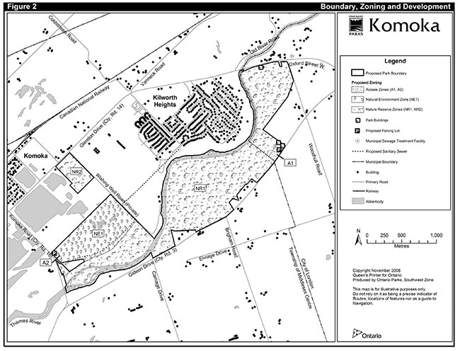
The park will be expanded to include two parcels previously acquired for park purposes (see Figures 1 and 2), bringing the area of the park to 324 ha. Other lands may be acquired and added to the park in the future, provided they meet the criteria described in the plan.
Most of the park’s significant natural heritage features will be protected in nature reserve zones (261 ha). The rest of the park will be zoned as natural environment (59 ha) or access (4 ha). A new access point will be developed in Zone A1 and will replace the existing access points on Gideon Drive and Oxford Street (see Figures 1 and 2).
Ontario Parks will evaluate projects for the management and restoration of landforms, vegetation, and wildlife. Aquatic life in the Thames River will be managed in partnership with other responsible agencies.
Horseback riding and mountain biking will be permitted on designated trails only for a two year period following the approval of the Komoka Park Management Plan. During this period Ontario Parks will monitor trail use to determine user compliance with park rules and to assess trail impacts and user compatibility. Based upon the results of the two year monitoring period Ontario Parks will develop a recommended long term policy for trail use. Ontario Parks will consult with interest groups and stakeholders on the recommended policy. Any recommended change in policy will be processed as an amendment to the management plan. During the consultation period and plan amendment process, all trail uses will be permitted to continue with the same conditions as applied during the two year monitoring period.
No off-road vehicle use will be permitted. Dogs will be required to be on leash at all times. Non-compliance with park rules could result in enforcement action or curtailment of access immediately for the offending user.
Development in access zones will be limited to roads and parking, picnic sites and privies, and basic interpretive and management facilities. In the rest of the park, the only development will be trails and minimal interpretive facilities. Ontario Parks will undertake a trail system review to determine which existing trails should be closed or relocated and what new trails should be developed.
Self-service collection of fees may be introduced if and when revenues would justify the cost of collection.
For more information in French, please contact the Natural Resources Information and Support Centre at 1-800-667-1840.
1.0 Context
1.1 Provincial Parks and Conservation Reserves Act
The Provincial Parks and Conservation Reserves Act (PPCRA) is the legislation that guides the planning and management of the protected areas system. The PPCRA has two specific principles that guide all aspects of planning and management of Ontario’s system of provincial parks and conservation reserves:
- Maintenance of ecological integrity shall be the first priority and the restoration of ecological integrity shall be considered.
- Opportunities for consultation shall be provided. 2006, c. 12, s. 3.
1.2 Statement of Environmental Values and the Environmental Bill of Rights
The Ministry of Natural Resources' Statement of Environmental Values (SEV) under the Environmental Bill of Rights (EBR) describes how the purposes of the EBR are to be considered whenever decisions are made in the Ministry that might significantly affect the environment. This includes decisions made as a result of preparing management direction for a protected area.
The Ministry’s SEV has been considered throughout the planning process. The management direction for Komoka Provincial Park will further the objectives of managing Ontario’s resources on an environmentally sustainable basis.
1.3 Aboriginal peoples
A number of artifacts have been recovered within the study area including Woodland pottery and several spear points from along the north shore of the Thames River. South of the river, found artifacts suggest that the Komoka area was occupied by at least five different cultures during a span of 7,000 years. Today, local Aboriginal communities include the Chippewas of the Thames, Muncee-Delaware Nation, Oneida Nation of the Thames and Delaware Nation and Bkwejwanong Territory (Walpole Island).
1.4 Planning context
This park management plan has been prepared consistent with direction contained in Our Sustainable Future, Ministry of Natural Resources Strategic Directions (2005). The Ministry’s vision is "sustainable development"; and the Ministry’s mission is "ecological sustainability". The Ontario Parks program contributes mainly to the goal of "Healthy Natural Environment for Ontarians", but contributes to other strategic elements as well. The mandate of the Ministry for Ontario Parks is to deliver Ontario’s parks and protected areas program, which includes: the protection and management of provincially significant natural, cultural, and recreational environments; provincial parks operations; provision of tourism opportunities and natural heritage education; planning and management of parks and protected areas; policy leadership on conservation reserves; and monitoring, auditing, and public reporting on Ontario’s parks and protected areas.
This document has also been prepared consistent with direction contained in Protecting What Sustains Us: Ontario’s Biodiversity Strategy (2005). Ontario Parks supports both the first goal "Protect the genetic, species and ecosystem diversity of Ontario", and the second goal "Use and develop the biological assets of Ontario sustainably, and capture benefits from such use for Ontarians". In particular Komoka Provincial Park will be managed to protect any species at risk
1.5 Consultation
1.5.1 Summary and results of Aboriginal consultation
Aboriginal consultation for the Komoka park management planning process consisted of:
- representation from the Chippewas of the Thames First Nation on the Komoka Provincial Park Management Plan Advisory Committee;
- the direct mailing of notices and draft documents, in advance of initiating the formal public consultation process, to a number of Aboriginal groups inviting them to review and comment and to attend public open houses (January 2004 and February 2008);
- additional correspondence was subsequently sent to the Chiefs of the Chippewas of the Thames, Muncee-Delaware Nation, Oneida Nation of the Thames and Delaware Nation to provide an update on the status of the planning process and to reiterate that Ontario Parks is prepared to consult directly with their communities on this planning project.
1.5.2 Summary and results of public consultation
The public was first invited to participate in management planning for Komoka Provincial Park in July 2001, through a mailing of notices and Park Management Plan Terms of Reference to 170 individuals and groups then known to be interested, advertisements in three area newspapers, and posting on the Environmental Registry web site under the Environmental Bill of Rights. The Terms of Reference document was also posted on the Ontario Parks web site. Comments on the Terms of Reference were invited until September 6, 2001.
An Advisory Committee was also established, to provide advice and recommendations to Ontario Parks and its consultants throughout the planning process. Terms of reference for the advisory committee are included in the Park Management Plan Terms of Reference. The advisory committee consists of 12 persons knowledgeable about the park, including representatives of municipal and Aboriginal governments, conservation authorities, environmental groups, recreational user groups, community groups, and the scientific research community.
In December 2003, the document and notices of an upcoming open house were circulated through a mailing to the 317 individuals and groups on the mailing list, and 41 additional mailings in response to individual inquiries.
Komoka Provincial Park Background Information, Issues and Options and the open house were also publicized through a posting on the Environmental Registry web site, and advertisements in two area newspapers in January 2004. The document itself was posted on the Ontario Parks web site.
The open house was held at the Komoka Community Centre on January 28, 2004 and was attended by about 160 people.
Comments on Komoka Provincial Park Background Information, Issues and Options were invited until February 27, 2004. Ontario Parks received 129 responses. Highlights are provided in Komoka Background Information, Issues and Options: Summary of Public Response, available from Ontario Parks.
The Komoka Preliminary Park Management Plan was published in January 2008. In late January 2008, the document, and notices of an upcoming open house were circulated through a mailing to the 457 individuals and groups then on the mailing list.
The Komoka Preliminary Park Management Plan was also publicized through a posting on the Environmental Registry web site, and advertisements in three area newspapers in January/February 2008. The document itself was posted on the Ontario Parks' web site.
An open house was held at the Delaware Community Centre on February 7, 2008 and was attended by about 120 people.
As a follow up to the open house, a meeting with 57 supporters of horseback riding was held in London on March 18, 2008. Another meeting was held with 11 members of the McIlwraith Field Naturalists (now Nature London) and Thames Valley Trail Association near London on April 9, 2008. Ontario Parks staff also accepted an invitation to attend a Middlesex County Council meeting on May 13, 2008.
Comments on Komoka Preliminary Park Management Plan were invited until March 10, 2008 as indicated in local newspaper advertisements and mailings. The due date for comments was extended to March 25, 2008, in the Environmental Registry notice for the project. Further extensions were offered to several groups which requested additional time to comment. Ontario Parks received 131 written submissions. Of these, the two most common responses were to allow horseback riding in the park (47 responses) and to prohibit horseback riding/mountain biking/change classification of the park to nature reserve (59 responses). A petition with 862 signatures was also submitted in support of horseback riding in the park while four Minister’s letters were received requesting a change in proposed park classification from natural environment to nature reserve thus excluding uses such as horseback riding and mountain biking from the park.
All comments received on the preliminary park management plan were reviewed by Ontario Parks. The Ontario Parks planning team prepared the final park management plan for Komoka Provincial Park, taking these comments into account.
The Komoka Park Management Plan was published in May 2010. Subsequently, the document and notices of an upcoming open house were circulated through a mailing to the 585 individuals and groups on the mailing list. The Komoka Park Management Plan was also publicized through a policy decision notice posted on the Environmental Registry web site, and advertisements in four area newspapers in June 2010. The document itself was posted on the Ontario Parks' web site.
1.6 Summary of significant management topics
The Komoka Provincial Park Background Information, Issues and Options document:
- outlined 21 planning and management issues that should be addressed by the park management plan; and
- described four alternative concepts for the park’s future, including the most appropriate classification, boundaries, and management and development direction for each alternative.
This section of the park management plan discusses the issues that were most commented on during public review of the Komoka Provincial Park Background Information, Issues and Options document, and summarizes how the plan will deal with those issues. The issues are listed in the order they appear in Section 5 of Komoka Provincial Park Background Information, Issues and Options. For more information on how the plan responds to each issue, please refer to the sections indicated. For details on the public consultation conducted, see Section 1.5.
There was not enough comment on the four alternative concepts to indicate a clearly preferred alternative.
Komoka Background Information, Issues and Options: Summary of Public Response (June 2004) provides more detail on public response and is available from Ontario Parks.
1.6.1 Classification
Comments: Most respondents on this issue felt that Komoka should no longer be classed as a recreational park, but were divided between natural environment and nature reserve as a preferred alternative.
Response: Komoka will be classed as a natural environment park (Section 3.0).
1.6.2 Boundaries
Comments: Few comments were received on this issue, but the greatest support was for maintaining the existing park boundary. Some respondents advocated various scenarios involving adding the acquired lands and, in some cases, private lands.
Response: The park will be expanded, but only to include those lands already acquired by MNR for park purposes. Any other lands that MNR may acquire in future, in accordance with the criteria in Section 6.0, would be added to the park at that time (Section 6.0).
1.6.3 Access
Comments: There was no clear preference for any approach.
Response: There will be two formal access points to the park. The existing access points south of the Thames, on Oxford Street and Gideon Drive, will be closed over time and replaced with an improved access area farther east on Gideon Drive. A single access south of the Thames will be more efficient to manage, and the Oxford Street access is not ideally located in terms of traffic safety. To provide access to the lands to be added to the park north of the Thames, the existing access off Komoka Road will be improved (Section 9.3).
1.6.4 Uses
Comments: Respondents urged that trail uses which they felt were in conflict should be better separated or not permitted.
Response: The park management plan will attempt to reduce conflicts and enhance public safety by prohibiting all-terrain vehicle use within the park and requiring that a trail system review be undertaken.
1.6.5 Development
Comments: There was a strong "keep the park as it is" sentiment among respondents. In particular, major day use facilities, camping facilities, and a golf course were mentioned as inappropriate.
Response: Development will be limited to facilities necessary to better support existing low intensity day use activities: trail recreation, canoeing, fishing, and nature appreciation (Table 1, Section 8.6).
1.6.6 Trails
Comments: Respondents recommended that the trail network be improved, particularly by eliminating duplicate trails and removing trails from locations where they may impair park values. Most of those commenting on horseback riding endorsed continuing this activity with no or some restrictions. Most of those commenting on mountain biking advocated prohibiting this activity, or continuing it with restrictions.
Response: A trail system review will ensure that trails are located so as to provide better circulation, allow for more efficient maintenance, and better protect park values. Conditions will be placed on horseback riding and mountain biking within the park (Section 8.4).
1.6.7 Prohibited uses
Comments: Most respondents urged that activities currently prohibited in provincial parks be more effectively enforced, specifically dogs off-leash and off-road vehicle use. Many also advocated partial or complete prohibition of dogs on-leash.
Response: Existing prohibitions under Ontario’s Provincial Parks and Conservation Reserves Act and its regulations, will be more effectively communicated and enforced. The plan will also indicate that the park superintendent has the authority to restrict or prohibit any use (which includes dogs on-leash) at any time, if required to protect park values or public safety (Table 1).
1.6.8 Natural heritage protection
Comments: Respondents strongly emphasized the need to better protect the park’s natural heritage values. Though not mentioned in Komoka Provincial Park Background Information, Issues and Options, white-tailed deer overpopulation and its impact on vegetation was identified as an associated issue by a number of respondents.
Response: Almost all of the provincially significant Areas of Natural and Scientific Interest (ANSI) which encompass the park’s most significant natural heritage features will be included in nature reserve zones. Natural heritage protection will also be accomplished through a variety of management plan measures, including the trail system review, more effective prohibition of nonconforming uses, and restoration plans for currently disturbed areas. A park operating plan will ensure that staffing and enforcement are consistent with provincial standards. There is not yet sufficient evidence for the management plan to require deer population reduction. However, the management plan will indicate that the park superintendent has the general authority to control overabundant animal populations when essential to protect natural heritage values, and will encourage further research into deer overpopulation (Sections 8.3, 8.5, and 9.1).
2.0 Introduction
"The land is much more interesting than may appear (on a map) because of the grandness of the relief within it and the geomorphological history of it. The [Thames] river is deeply entrenched and forms therefore a beautiful valley with steeply sloping and heavily wooded valley sides interspersed with raw and exposed cliff like banks to 125 feet in height. To add to the interest of this wilderness river core, the land to the southeast of the river is higher than that to the north by as much as 60 feet offering contrasting impressions depending on which side of the river one is on. Looking south across the river one is looking into a forested wall. Looking north across the river, one has the long birds eye view of the land and the feeling of great height, a rather unique aspect in the flat lands of South-western Ontario." - Osmond Langtvet, A Proposal for the Establishment of a Wilderness Park Straddling the Thames River between the Kilworth and Komoka Bridges, Delaware and Lobo Townships, Middlesex County, Ontario, 1964.
These attributes of what is now Komoka Provincial Park inspired Dr. Langtvet, a University of Western Ontario geography professor, to make this first known proposal for protecting Komoka. Dr. Langtvet knew that Komoka was significant in several ways, which have become better understood and appreciated over the 40 years since:
- The Thames valley is the park’s most significant landscape feature. The park contains the best example of the valley’s distinct topography southwest of London. The raised (former) beaches of the glacial lakes that preceded the Thames are a provincially significant earth science feature
- The Thames River is one of Southern Ontario’s major rivers. In 2000, it was designated a Canadian Heritage River following submission and acceptance of The Thames Strategy: Managing the Thames as a Canadian Heritage River
- The naturally vegetated corridor along the river includes a variety of shoreline, wetland, forest, and meadow habitats, which together constitute a provincially significant life science feature, (see Section 9)
- The park is, or has the potential to be, home to several plant, butterfly, reptile, bird, mammal, and fish species at risk. (In this plan, "species at risk" are as listed on the Species at Risk in Ontario List regulation. Species observations cited are as of April 2004 and are subject to change.)
- The park is a key natural core along the Thames River corridor and is the largest remaining natural area within 15 kilometres (km) of downtown London
- It has been a valued natural recreation area for London area residents since the 1970s
- The park is one of the major remaining stretches of riparian forest and adjoining upland forest in southwestern Ontario, and plays a crucial role as a corridor for plant dispersal and wildlife migration
Osmond Langtvet’s 1964 proposal caught the interest of the County of Middlesex and eventually the Ontario Government. In 1974, the province announced that a near-urban recreational class provincial park would be established, and began to acquire land.
Although several near-urban provincial parks were considered in the early 1970s, only one was actually developed, Bronte Creek in Oakville. As a result of financial constraints, landowner opposition, and changing priorities, land acquisition at Komoka was slow, and no major facilities were developed.
In 1989, Komoka Provincial Park was legally established, to include the Thames River between the Oxford Street/Glendon Drive and Komoka Road bridges, and all the lands acquired south of the Thames, totalling 198 ha. Lands acquired for park purposes north of the Thames are not part of the current regulated park, but are recommended for regulation (Section 6). Komoka has since been managed as a non-operating park, with minimal facilities and no fee collection. Current estimated park visitation is 50,000 users per year.
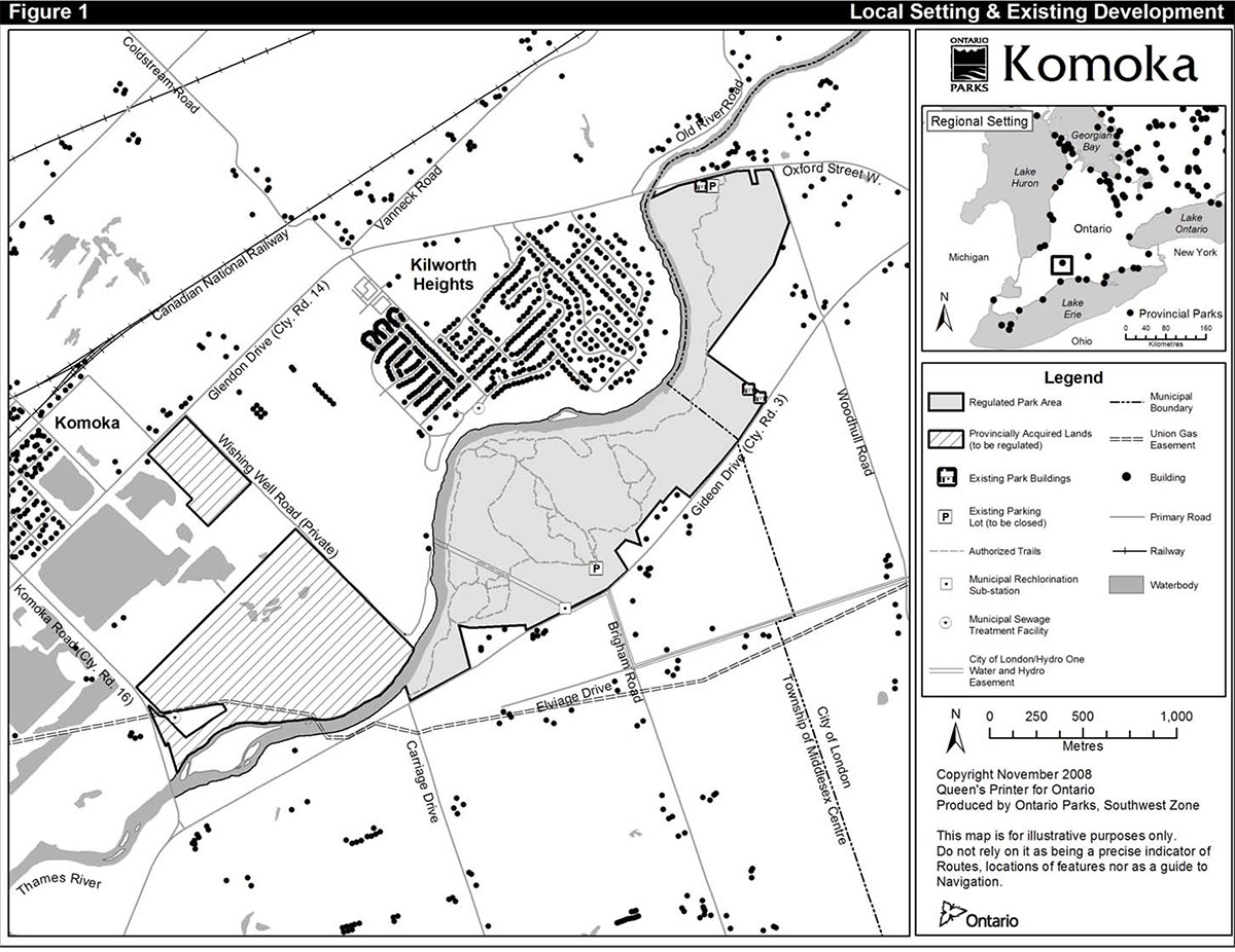
Most of the park is adjacent to the Municipality of Middlesex Centre, while the easternmost part abuts the City of London. Figure 1 shows the park’s setting within southwestern Ontario, and its relationship to other provincial parks.
Detailed information on the park’s setting, facilities, natural and cultural heritage, market area, and current uses is provided in the Komoka Provincial Park Background Information, Issues and Options document, available from Ontario Parks.
The approved park management plan supersedes the 1979 Kilworth/Komoka Public Lands (Park Reserve) Interim Management Statement, and will guide the long-term protection, development, management, and operation of Komoka Provincial Park. Section 11 describes the process for review and amendment of the approved management plan.
Figure 1: Local Setting and Existing Development

Enlarge Figure 1: Local Setting and Existing Development
3.0 Park classification
Through park classification, Ontario’s provincial parks are organized into broad categories, each of which has particular purposes and characteristics. Komoka Provincial Park, formerly classed as a recreational park, will now be classed as a natural environment park, one of six classes of parks in the Ontario provincial parks system.
The change in classification reflects Komoka’s significance in that the park protects 13
Natural environment parks protect outstanding recreational landscapes, representative ecosystems and provincially significant elements of Ontario’s natural and cultural heritage and provide high quality recreational and educational experiences.
4.0 Goal
The goal for the park is:
- To protect Komoka Provincial Park’s significant natural and cultural heritage, and provide high quality natural heritage educational experiences and only those recreational activities appropriate to and ecologically sustainable within the park’s environment
Komoka Provincial Park is governed by the Provincial Parks and Conservation Reserves Act and Ontario Provincial Parks: Planning and Management Policies (1992).
5.0 Objectives
Ontario’s Protected Areas system has four objectives for establishing and managing provincial parks, as stated in Ontario’s Provincial Parks and Conservation Reserves Act:
- to permanently protect representative ecosystems, biodiversity and provincially significant elements of Ontario’s natural and cultural heritage and to manage these areas to ensure that ecological integrity is maintained
- to provide opportunities for ecologically sustainable outdoor recreation opportunities and encourage associated economic benefits
- to provide opportunities for residents of Ontario and visitors to increase their knowledge and appreciation of Ontario’s natural and cultural heritage; and
- to facilitate scientific research and to provide points of reference to support monitoring of ecological change on the broader landscape
As a natural environment park, Komoka will contribute to all four objectives. Komoka contributes to these objectives in the following ways.
5.1 Protection objective
In Ontario, the Ministry of Natural Resources delineates natural regions to enable landscape planning and monitoring. Ontario is divided into 71 Ecodistricts (formerly known as ecological site districts) based on landforms and biological productivity. For protected area system planning purposes, protected areas establishment is designed to be representative of the Ecodistricts in which they are found. The target is to establish at least one natural environment park in each Ecodistrict. Komoka and The Pinery Provincial Parks are the two natural environment parks in Ecodistrict 7E-2, and protect natural environments representative of this Ecodistrict. The specific significant features protected in the park’s nature reserve zones are described in Section 9.1.
Protection will not be limited to provincially significant features. The entire park will be maintained as a healthy, diverse, and sustainable natural environment, consistent with achieving the park’s other objectives. Degraded environments will be restored wherever possible.
Protection will also be accomplished through an ecosystem approach that recognizes the ecological, social, and economic influence that the surrounding area has on the park. This is particularly important at Komoka given the park’s proximity to London and the increasing urbanization of the surrounding landscape. Policies of this plan that address issues beyond the park boundary will be based on cooperation and partnership. These policies will not intervene in local affairs or restrict private property rights beyond the mandate of the Planning Act.
5.2 Recreation objective
Walking, fishing, and canoeing are expected to continue to be the principal recreational activities in the park. Horseback riding and mountain biking will be allowed to continue, on designated trails only, for a two year review period following approval of this plan. Ontario Parks will seek to increase day use in an ecologically sustainable manner by improving trail and access facilities. Sub-section 8.4 outlines the recreation management policies for the park.
5.3 Heritage appreciation objective
To the extent that it is compatible with the park’s protection objective, Ontario Parks will provide self-guided facilities and programs to enhance existing and future opportunities for unstructured individual exploration and appreciation.
5.4 Scientific research objective
Research by qualified individuals that contributes to knowledge of natural and cultural history and to environmental and recreational management of the park will be encouraged. Inventories and monitoring may be conducted, as necessary, to provide information to support planning and management decisions intended to ensure the ecological sustainability of the park.
6.0 Boundary
Park management plan policies apply only to the area within the regulated boundary of the park. Within the park boundary, the protection of park values and features will be achieved through appropriate zoning, the control of land use and activities, education, and monitoring of ecological impacts. Any boundary change, land acquisition, or land disposition will be undertaken in accordance with the requirements of A Class Environmental Assessment for Provincial Parks and Conservation Reserves approved under the Environmental Assessment Act.
Figure 1 shows the boundary of Komoka Provincial Park as established in 1989 by Ontario Regulation 290/89 under the former Provincial Parks Act
Amending the boundary will add to the park two parcels acquired by MNR for park purposes:
- a former gravel pit immediately north of the Thames River; and
- a woodlot on Glendon Drive, separated from the rest of the park
With the addition of these parcels the expanded park will be approximately 324 ha in area.
Engineering reviews conducted in 2001 of the Municipality of Middlesex Centre and City of London water supply systems determined that drinking water for the community of Delaware should be provided from London, through existing mains along Gideon Drive. It was also determined that a rechlorination facility was needed, and that it would be best located on park lands abutting the Gideon Drive road allowance. Ontario Parks agreed to this proposal, which would require removing from the park about 100 m² abutting Gideon Drive west of Brigham Road (see Figure 1), and conveying it to the Municipality. This will be reflected in the amended boundary. With authorization from Ontario Parks, the Municipality built the facility in 2003.
MNR will consider acquiring other land and adding it to the park, subject to the following criteria:
- the seller is willing
- funds are available
- the land abuts the park or is separated from it only by a municipal road allowance or is otherwise nearby and is a part of a natural system of benefit to the park; and
- the land is one or more of the following:
- within a provincially significant ANSI
- habitat for species at risk
- as a result of how its resources are managed, adversely affecting natural heritage values in the park
- a potential buffer that would better protect natural heritage values in the park
- a potential link between the Glendon Drive woodlot and the rest of the park
- a potential link in a natural heritage corridor; and/or
- a potential contributor to improving public access to the park
Figure 2: Boundary, Zoning and Development
Enlarge Figure 2: Boundary, Zoning and Development
The bed of the Thames River is Crown land. MNR will consider adding portions of the river above Oxford Street/Glendon Drive and below Komoka Road to the park to protect habitat for aquatic species at risk.
As shown on Figures 1 and 2, there is an area of land just east of Komoka Road that is almost entirely surrounded by, but is not part of, the former gravel pit to be added to the park. This is owned by the Municipality of Middlesex Centre, and consists of a municipal sewage treatment facility and a road allowance providing access to it. If at some point the Municipality no longer needs this land for this purpose, MNR will consider acquiring it subject to the above criteria.
Where development or site alteration is proposed for abutting lands, as part of its input to the planning review process Ontario Parks may seek conditions of approval requiring applicants to mitigate potential adverse impacts by, for example, setting development back from the park boundary and/or providing appropriate fencing along the boundary.
Otherwise, the park superintendent will clearly define the park boundary by signage, planting, fencing or other method as appropriate, where needed to protect park values and achieve the policies of this plan, or where requested by abutting owners, all in accordance with any applicable requirements of the Line Fences Act. Fencing will be designed so as to minimize interference with wildlife movement. Open pedestrian access will be maintained to the Thames Valley Trail as described in Section 8.4.
The former gravel pit and woodlot to be added to the park are bounded on the east by a private road, known as Wishing Well Road. This private road forms the western edge of lands that will be developed as the community of Kilworth Heights grows. As part of its input to the planning review process for these lands, Ontario Parks may seek a condition of approval requiring the applicant to provide an easement or right-of-way over Wishing Well Road giving Ontario Parks access to the park for management purposes. Public access will not be provided from Wishing Well Road.
This plan recognizes the following continuing uses of park lands, as shown on Figure 1:
- Union Gas holds an easement for a gas transmission pipeline right-of-way that crosses the west end of the park
- The City of London holds an easement for a water main from wells on the north side of the Thames River, to Gideon Drive
- Hydro One Networks Inc. holds an easement for a power line along the same route, to provide electricity to the wells
- The wells, main, and power line may be decommissioned, and if this happens, the easements would be surrendered and rehabilitated
Ontario Parks and the Municipality of Middlesex Centre have been discussing since 1995 the location of a new sanitary sewer, from Kilworth to the sewage treatment facility east of Komoka Road. This sewer would cross the former gravel pit being added to the park (see Figure 2). Ontario Parks has agreed to provide an easement to the Municipality for this purpose. The easement would be located so as to minimize adverse effects on natural and cultural heritage values, and the Municipality would be required to undertake all appropriate rehabilitation.
Disposition of park land for public benefit (e.g. municipal drainage, water or sewer easements) may be considered subject to review and approval by Ontario Parks. Dispositions carried forward for consideration will undergo project screening and evaluation (including consultation) as per the Class Environmental Assessment for Provincial Parks and Conservation Reserves. Ontario Parks may impose terms and conditions on authorized dispositions. Dispositions for private or commercial use will not be permitted.
7.0 Adjacent land uses
In 1964, when Osmond Langtvet first proposed a park at Komoka, the City of London’s population was about 185,000, and that of Middlesex County including the City, about 240,000. Both are now within sight of doubling their populations. By 2021, the City is expected to reach about 425,000, and the County plus City, about 515,000. The landscape around the park, essentially rural in 1964, will continue to urbanize.
Other public infrastructure developments expected over the next 20 years in the area include:
- widening of Oxford Street to Commissioners Road
- a possible ring road expressway that would extend north from Highway 402 and pass just east of the park; and
- expansion of the sewage treatment facility east of Komoka Road, and construction of a new sewer to it as described in Section 6.0
In this context, it is essential to recognize that Komoka Provincial Park may progressively become more insular as surrounding developments proceed. In this case, Komoka Provincial Park’s role as a core area within a broader landscape level ecosystem becomes increasingly more important. Figure 4 in Komoka Provincial Park Background Information, Issues and Options shows Komoka in relation to existing and potential natural cores and corridors in central Middlesex. Ontario Parks will support partnerships that build upon landscape strategies, such as Carolinian Canada Coalition’s The Big Picture Project, to secure, restore or enhance the natural heritage system that Komoka Provincial Park is part of.
Most of the park contains natural heritage features and areas defined by the Provincial Policy Statement (2005) under the Planning Act. Municipalities are required to be consistent with provincial policy that natural heritage features and areas are to be protected from incompatible development on adjacent lands. Provincial policy also requires municipalities to consider the impacts of planning decisions on provincial parks. MNR will provide the necessary information and with the assistance of the Ministry of Municipal Affairs and Housing work with the Municipality of Middlesex Centre and the City of London to ensure that their official plans fully identify the park’s lands, waters, and natural heritage features, so that new development near the park is assessed with regard to any potential impacts on the park and its natural heritage values in accordance with provincial policy.
Also, the Provincial Policy Statement requires municipalities to be consistent with the policy that "the diversity and connectivity of natural features in an area, and the long-term ecological function and biodiversity of natural heritage systems, should be maintained, restored or, where possible, improved, recognizing linkages between and among natural heritage features and areas, surface water features and ground water features". Natural heritage systems may include lands that have been restored and areas with the potential to be restored to a natural state, as well as currently identified natural heritage features. MNR will work with other ministries and municipalities to promote planning policies that, by implementing this Provincial Policy Statement direction in the park’s surrounding area, will enhance Komoka’s contribution to the biodiversity of the deciduous (Carolinian) forest region of Ontario.
8.0 Park policies
The following policies apply to the whole park.
8.1 Industrial uses
The following commercial/industrial activities are prohibited in Komoka Provincial Park according to the Provincial Parks and Conservation Reserves Act.
- commercial timber harvest
- prospecting, staking of mining claims, developing mineral interests, or working mines are not permitted
- extracting aggregate, topsoil or peat
- generation of electricity; and
- other industrial uses
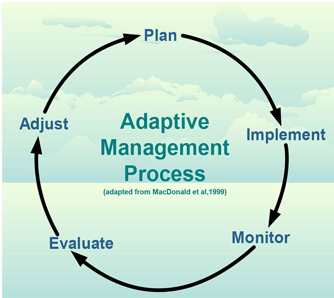
8.2 Adaptive management
An adaptive management approach will be applied to resource management activities within Komoka Provincial Park.
Adaptive management allows for modification of management strategies in response to monitoring and analysis of the results of past actions and experiences. Figure 3 shows adaptive management as a systematic, practical approach to improving resource management.
Figure 3: Adaptive management process
8.3 Resource management policies
Ontario Parks will evaluate projects for the management and restoration of landforms, vegetation, species at risk, and fish and wildlife habitat. The evaluations will specify appropriate techniques, and identify priority areas for their application. Along with the policies in Section 8.3, specific principles to be adhered to in preparing project evaluations will include the following:
- The aim of management and restoration will be to:
- in nature reserve zones, perpetuate the natural heritage values which the zone has been established to protect
- in natural environment zones, protect significant natural heritage values that are present, and in the long term, restore natural features and ecological functions; and
- in access zones, protect significant natural heritage values that are present
- "Management and restoration" will generally mean maintaining natural environments in, or restoring them to, their historic
footnote 4 condition as nearly as possible, at which point those environments will be left to evolve naturally and without human interference, except as specifically prescribed in this plan. In some cases, continuing active management to maintain a particular habitat condition or stage of natural succession that does not represent original conditions (for example, an old field) may be justified if it contributes to the park’s overall biodiversity. - Natural processes will be used except where other approaches are specifically prescribed by this plan
- Priority will be given to restoration techniques that are judged to be most likely to succeed and to have the most substantial positive impact relative to cost
- Visitor education will be fundamental to successful implementation
This plan recognizes the inherent rights of the Aboriginal communities and acknowledges that their traditional activities in Komoka Provincial Park will not be affected by the following park policies, provided that safety and conservation concerns are not compromised.
8.3.1 Land management
Old post and wire farm fences within the park boundary pose a potential safety hazard and will be removed, starting with those nearest trails and other higher use areas.
Wherever possible, new development or redevelopment will be undertaken so as not to disrupt natural drainage. Management will focus on restoring natural drainage where it has been disrupted by past or present development. Ontario Parks may consider reconfiguring the landforms and water features in Zone NE1 so as to better restore natural features (e.g., grassland and wetland habitats) and ecological functions.
Waste consisting of natural materials will be reused or composted inside the park where feasible and appropriate. Otherwise, all solid waste will be removed from the park for recycling or disposal.
8.3.2 Alien and invasive species
Alien species are plants, animals, and micro-organisms that have been accidentally or deliberately introduced by human activity into habitats outside their normal range. Invasive species are those harmful alien species whose introduction or spread threatens the environment, the economy and/or society, including human health. Alien species may originate from other continents, adjacent countries or from other ecosystems within Ontario or Canada. Free from predation and competition that would normally limit their distribution and abundance in their natural habitats; many of these invasive species reproduce quickly. Invasive species may negatively affect native species and/or habitats, as well as agricultural crops, causing significant ecological and economic damage. Alien species will not be deliberately introduced into the park.
Alien species associated with historical agricultural uses are present in the park. Horse manure is a documented vector of invasive species seeds in natural areas. Garlic mustard is an invasive plant that displaces native forest flora which is having an adverse impact on the ecological integrity of the park. White tailed deer avoid eating garlic mustard and browse native plants. The high population of deer gives garlic mustard an advantage over native flora in competition for the forest floor.
Where practical and feasible, actions will be taken to eliminate or reduce the threat of invasive species which may be affecting the diversity of naturally occurring populations. Prescribed burns may be used to encourage native flora to establish or expand in the meadow habitat and discourage alien species from expanding their range.
8.3.3 Extirpated and existing native species
Extirpated native species may be reintroduced, and existing populations replenished, if biologically feasible and acceptable, and desirable for perpetuating park values. This park-wide policy does not apply to the Thames River fisheries. Existing stands may also be replenished where necessary to rehabilitate disturbed areas expected to sustain continuing heavy use (such as trails). Planting will use seed stocks native to the park, or local seed zone, wherever possible.
8.3.4 Insects and diseases
Native insects and diseases affecting vegetation will be allowed to progress naturally, except where they threaten significant natural heritage values, in which cases they will be controlled where feasible. Alien insects and diseases will be controlled where feasible. Where control is undertaken, it will be directed as narrowly as possible to the specific insect or disease so as to have minimal effects on the rest of the park’s environment. Biological controls will be used whenever possible.
Chemical fertilizers will not be used in the park. Chemical herbicides, pesticides, and suppressants will not be used for any vegetation management purpose except:
- insect and disease control and fire suppression under the conditions set out in this section of the plan
- eradication of alien species, where it has been demonstrated that other methods with less residual impact on the park’s environment are not feasible; and
- control of poison ivy in access zones
Management of vegetation within the park will be directed to support the evolving natural succession of plant communities.
Emergency measures may be considered to protect the park’s features and values and would be subject to appropriate MNR approval.
8.3.5 Forest Fire Management
The Forest Fire Management Strategy for Ontario (OMNR 2004) provides strategic direction for the management of wildfire across Ontario. Komoka Provincial Park is in the Southern Ontario Fire Management Zone according to this provincial strategy. The City of London Fire Department and/or the Township of Middlesex Centre Fire Department are responsible for fire protection and response in the park. Ontario Parks will pursue an agreement with the municipalities for managing forest fires that occur within the park in accordance with MNR policy FM 2.04 (Fire Management South of the Fire Regions). The use of "light on the land" suppression techniques to reduce the impacts of fire response on park values will be negotiated with the responsible municipalities.
Komoka Provincial Park is located in a part of the province where tallgrass prairie and savannah communities were once more common. Fire plays an important role in developing and maintaining these communities, and in the absence of fire they will succeed to woodland and eventually be lost to forest. Komoka Provincial Park contains old field habitats that have been colonized by prairie species, and could be managed to promote prairie or savannah in these locations. Periodic fire in the form of prescribed burns would assist in achieving this goal.
Fire response within Komoka Provincial Park will focus on preventing personal injury, value loss and social disruption. Fires that pose a threat to public health and safety, property and infrastructure, or other values are a priority for suppression. Prescribed burning to promote the conversion of old fields to prairie or savannah habitats may be considered. Plans for any prescribed burning will be developed in accordance with MNR policy.
8.3.6 Species at risk
The park is home to several species at risk, as highlighted in Section 9.1.1. Species at risk will be protected consistent with the Endangered Species Act (ESA) and regulations.
Habitat for species at risk may be enhanced through the installation of artificial habitat features such as nesting boxes and hibernacula. Where this or any other active management is required for the recovery of a species at risk, it will be undertaken in accordance with any recovery strategy for the species developed under the ESA or the federal Species at Risk Act.
8.3.7 Vegetation management
In the part of Zone NR1 that is within the Komoka Park Reserve and Adjacent Lands life science ANSI, removal of planted conifers will be a long-term objective. In the rest of the park, further planning will determine whether planted conifers should be removed, thinned, or left alone.
Fields formerly utilized for agricultural purposes may be managed e.g., via prescribed burning, to maintain or enhance prairie/grassland habitat.
Except where they threaten public safety, dead trees will be left standing to serve as important homes for cavity-nesting birds and mammals. Live or dead trees and brush may be cut, pruned, or removed only:
- to enable resource management or facility development specifically authorized by this plan or by an approved implementation plan
- to ensure public safety; and
- in the utility easements specified in Section 6.0
Trees and brush cut in nature reserve and natural environment zones outside of conifer plantations will be left to deteriorate naturally as close as possible to where they have been felled. Trees and brush cut in conifer plantations and access zones will be left to deteriorate naturally as close as possible to where they have been felled, or used for wood chips in the park.
8.3.8 Wildlife management
Animal populations or individual nuisance (displaced) animals may be controlled when essential to human health and safety, the health of the species, or the values for which the park has been established. The reduction of overabundant populations, such as white-tailed deer, may be undertaken if population numbers exceed the park’s carrying capacity. Ontario Parks will manage deer numbers in the park at a level that represents the best scientific judgement as to what the habitat can sustainably support. If required, the population will be reduced as quickly as possible to within carrying capacity, and then maintained as required to keep population numbers stable. Wildlife population reduction will be undertaken directly by Ontario Parks, or through partnerships under the supervision of Ontario Parks. Where control is necessary, techniques which have minimal effects on other components of the park’s environment will be used.
Commercial trapping is not permitted in the park.
8.3.9 Fisheries management
The fisheries of the Thames River within the park will be managed by MNR in accordance with the recognized legislation, regulations, policies, plans, initiatives or programs prevailing for the river as a whole. Wherever possible, fisheries management will seek to maintain native, self-sustaining fish populations (in this plan, "fisheries" and "fish" have the same meanings as in the federal Fisheries Act, which refers to all marine animal life).
An aquatic ecosystem recovery strategy and action plan is currently being developed for the Thames River by a partnership of the Governments of Ontario (led by MNR) and Canada, the Upper Thames River and Lower Thames Valley conservation authorities, and the river’s Aboriginal governments. Ontario Parks will do its part in implementing the approved strategy and action plan within Komoka, subject to the requirements of A Class Environmental Assessment for Provincial Parks and Conservation Reserves, and will ensure that all management projects complement and support it.
8.3.10 Cultural resources management
Where a project involves ground disturbance in an area with archaeological potential, the project will be considered for impacts to archaeological resources. Where a project may impact on structures or cultural heritage landscapes, the project will be considered for potential effects to cultural heritage resources and appropriate mitigation measures will be considered. Staff will consult MNR's Technical Guideline for Cultural Heritage Resources.
Cultural features, if found, will be evaluated and their significance determined. Those features deemed significant will be protected from incompatible development wherever they occur in the park. Incompatible resource uses and recreational activities will be restricted or prohibited where necessary in accordance with the cultural heritage guidelines in order to protect significant cultural heritage values. Archaeological and historical artifacts may only be removed as part of approved cultural heritage research or management projects by qualified experts and subject to applicable legislation, guidelines, policies and procedures and the Class Environmental Assessment for Provincial Parks and Conservation Reserves.
The former Kilworth post office has been determined not to be a significant cultural feature and has been declared surplus to park needs. The Ontario Realty Corporation is now responsible for its disposition.
Ontario Parks will continue to work cooperatively with the Upper Thames River Conservation Authority toward supporting the Canadian Heritage River designation of the Thames River in areas associated with Komoka Provincial Park.
Although a preliminary archaeological survey of the park was carried out in 1974, further study is required and will be encouraged. Management strategies for any archaeological sites found in the future may range from allowing the sites to evolve without human interference, to research, excavation, and rehabilitation. All research, protection, and management will be undertaken in consultation with the Ministry of Culture and nearby Aboriginal communities.
8.3.11 Scientific collecting
The collection of fossils, rocks, minerals, archaeological/cultural artifacts, plants and seeds is only permitted by research permit and/or scientific collector permit.
8.3.12 Research
Scientific research by qualified individuals which contributes to the knowledge of natural and cultural history and to environmental management will be encouraged. All research will be conducted by, or authorized by, Ontario Parks.
Research projects will be administered through park policy directive PM 2.45 (Research Activities in Provincial Parks) and requires a research permit. Research must also meet all requirements under applicable provincial and federal legislation. Direction for research activities in the park should be consistent with the Research and Information Strategy, Ontario Parks, Southwest Zone (2009-2013). Approved research and monitoring activities must be consistent with Ontario Parks' Research and Information Strategy (1997).
Temporary facilities in support of approved research and monitoring activities may be considered.
Approved research activities and facilities will be compatible with protection values and/or recreational uses in the park, and will be subject to development and management policies associated with the park’s classification unless special permission is given.
Sites altered by research activities will be rehabilitated as closely to their previous condition as possible.
The following general fields of research are particularly appropriate for Komoka and will be encouraged:
- landforms, vegetation, fish, wildlife, and archaeology of the park
- the status and life history requirements of species at risk and other rare species and communities
- the status and possible overabundance of deer; and
- environmental restoration and management
8.3.13 Inventory and monitoring
Planning and management decisions are intended to ensure the ecological integrity of protected areas. Considerations will be given to social and economic components. Ontario Parks will ensure that these decisions are made with the best available information. Where this information is lacking, Ontario Parks may conduct inventories and monitoring, as necessary, to provide this information. Such efforts will be undertaken based on established methodologies and best practices. Inventory and monitoring will foster an adaptive management approach to protected areas management. Some broad approaches for identifying inventory and monitoring needs are management actions identified in this management plan, public input, routine park maintenance activities, staff knowledge and experiences and environmental scans.
Priority monitoring projects include:
- trail use and impacts to adjacent natural values
- species at risk populations and specific threats
- non-permitted uses and impacts to park values
- ash trees in the park in response to emerald ash borer (EAB)
- management efforts in the former gravel pit; and
- old field succession (to determine if active management is required, for instance, for alien species control and/or management of prairie/grassland habitat)
8.4 Recreation management policies
There are about 11 km of authorized trails in the park; all south of the Thames River (see Figure 1). This includes the end-to-end 4.4 km "white" trail, which is the Thames Valley Trail link within the park, and the "orange", "blue", and "yellow" systems. There are also about 15 km of unauthorized trails on both sides of the Thames. If the park boundaries are fenced where the Thames Valley Trail enters the park, stiles or similar facilities will be installed that will maintain access for pedestrians only.
Ontario Parks will undertake a trail system review to:
- determine which authorized trails should be closed and which should be relocated south of the Thames in order to better protect natural and cultural heritage values, improve circulation, reduce duplication and allow for more efficient maintenance
- confirm the continuing role of the trails system in providing a Thames Valley Trail link through the park
- design an appropriate system of authorized trails north of the Thames
- determine how unauthorized trails can be most effectively closed and rehabilitated; and
- specify appropriate trail development standards
Trail prescriptions that involve the Thames Valley Trail link will be prepared in partnership with the Thames Valley Trail Association.
Cross-country skiing will be permitted on all appropriate trails, although trails will not be managed for skiing.
Horseback riding and mountain biking will be permitted on designated trails only for a two year period following the approval of the Komoka Park Management Plan. During this period Ontario Parks will monitor trail use to determine user compliance with park rules and to assess trail impacts and trail user compatibility. Based upon the results of the two year monitoring period Ontario Parks will develop a recommended long term policy for trail use. Ontario Parks will consult with interest groups and stakeholders on the recommended policy. The final recommended change in policy will be processed as an amendment to the management plan. During the consultation period and plan amendment process, all trail uses will be permitted to continue with the same conditions as applied during the two year monitoring period.
The following minimum conditions must be obeyed by all riders to minimize ecological impacts and protect natural heritage values:
- riders must stay on designated trails
- riders must yield to pedestrian trail users (e.g., stop on trail to allow pedestrians to pass)
- riders must comply with seasonal trail restrictions (March – April) to avoid excessive trail damage through erosion and rutting
- horseback riders must outfit horses with manure bags
- horseback riders must appropriately dispose of manure outside of the park; and
- group rides must obtain the permission of the Park Superintendent.
No off-road vehicle use will be permitted
Dogs on-leash will be permitted within the park. No area will be established in the park for dogs off-leash.
Camping and camp fires are prohibited in the park.
Mooring of watercraft within the park will not be permitted in order to protect sensitive natural heritage features.
Ontario Parks will annually review park rule compliance. Non-compliance could result in enforcement action or curtailment of access immediately for the offending user.
8.4.1 Fees
Self-service collection of day use fees may be introduced in the access zones if and when the potential revenues would justify the collection costs. Fee collection may also be introduced at the existing interim access points before they are replaced by the Zone A1 access.
8.4.2 Sport hunting
Sport hunting is not permitted in the park.
8.4.3 Recreational fishing
Angling will continue to be subject to federal and provincial recreational fishing regulations.
8.4.4 Mechanized travel
No area will be established in the park for snowmobiling or all-terrain vehicle use.
Ontario Parks' staff may use motor vehicles and motorboats in the park to the extent necessary for efficient park management and operations. In approving research applications (see Section 8.3.12); Ontario Parks may authorize researchers to use motor vehicles and motorboats to the extent necessary for research to be conducted safely and efficiently. Both Ontario Parks' staff and approved researchers will conform wherever possible to the restrictions applicable to recreational users. Any other public agency may use any craft or vehicle for emergency services in the park, subject to the approval of the park superintendent.
8.5 Operations policies
Komoka Provincial Park will continue to be administered from Port Burwell Provincial Park. Specific direction for the management of all facilities and services at Komoka will be incorporated into the Port Burwell Provincial Park Operating Plan.
In addition to the policies that follow, the operating plan will address such topics as budgets, staffing, maintenance, enforcement, and emergency services. The operating plan will be consistent with this plan and the Ontario Provincial Parks Minimum Operating Standards, and will be reviewed annually and updated as required.
Park operations will depend on available funding. To ensure that operations continue to meet the standards of the operating plan, self-serve facilities may be developed, and individual volunteers and partner organizations may be involved in park programs.
8.5.1 Natural heritage education
Natural heritage education in provincial parks is intended to develop visitors' awareness and appreciation of Ontario’s natural and cultural heritage, fostering a commitment to protecting that heritage for current and future generations. Heritage education opportunities are meant to be educational and recreational, formal and informal, and accessible to all. There are three components of heritage education in parks: information, interpretation, and outdoor recreation. The level of service each park provides depends on its significance and visitation. At Komoka, heritage education will be at the self-use level, however personal service programs (e.g., guided walks) will be considered from volunteer groups upon the Superintendent’s approval.
Natural heritage education will be provided through:
- a park leaflet that will inform visitors about Komoka’s natural heritage values and their management and restoration, and the park’s recreational and self-guided interpretive opportunities. The leaflet may also provide additional information on park specific management topics (e.g., invasive species)
- provision of display panels and/or interpretive leaflets on some trails
- installation of viewing platforms and/or display panels at heritage sites of particular interest elsewhere in the park; and
- commemoration of Osmond Langtvet’s contribution to Komoka at an appropriate location in the park
Natural heritage education about Komoka may also be provided offsite, at any nearby public facilities that provide visitor contact opportunities beyond those available in the park.
Opportunities for fish and wildlife viewing will be encouraged in the park.
8.5.2 Partnerships
In the implementation of the approved park management plan, Ontario Parks may pursue opportunities for partnerships involving other agencies and groups through formal partnership agreements. Partners may represent the local community, and local and provincial interests. Partners will work with Ontario Parks to assist in the implementation of the approved park management plan and will follow provincial park policies and regulations.
Ontario Parks will encourage and assist the development of a Friends of Komoka Park organization, if there is sufficient public interest. A Friends organization could be an important partner in implementing plan initiatives such as producing interpretive and marketing materials, improving resource management, and improving trails. Partnerships for these purposes will also be explored with municipalities, Aboriginal communities, other public agencies, community and interest groups, and the private sector.
Existing partnerships to be continued include:
- advisory role in developing Thames River aquatic ecosystem recovery strategy (Government of Canada, conservation authorities, Aboriginal governments); and
- Thames Valley Trail link location and management (Thames Valley Trail Association)
8.5.3 Marketing
Opportunities to partner with other provincial and regional tourist agencies, chambers of commerce, business improvement associations and other organizations may be considered. A marketing plan may be prepared for the park if required and will be reviewed at three year intervals or as necessary.
8.6 Development policies
All development undertaken by Ontario Parks, or by partners on its behalf, will comply with A Class Environmental Assessment for Provincial Parks and Conservation Reserves, and will be carried out in accordance with approved site and development plans that meet development standards for provincial parks.
Areas proposed for development will require prior assessment for significant cultural heritage features and natural values such as species at risk to ensure these values are identified and protected at the site.
The location, design, and materials of all facilities will as much as possible reflect the natural environment character of the park. Durable, low maintenance, and energy-efficient designs and materials will be used wherever possible.
Ontario Parks will seek to ensure that any alterations by easement holders to the utility easements specified in Section 6.0 and to the utilities within them reflect the natural environment character of the park as much as possible.
Figure 2 shows the specific new developments authorized by this plan, except for trails, which will be authorized by the trail system review. Within the limits established by this plan, the final location and extent of all development will be determined through site and development planning.
In addition to the parking lots shown in Figure 2, and the access roads to them, the following facilities may be developed in Zones A1 and A2:
- self-service entry control and fee collection
- bicycle racks
- individual picnic sites
- privies
- display panels and other interpretive facilities
- garbage disposal; and
- basic management facilities (such as site office, maintenance shed)
The existing park buildings in Zone A1 may be used, renovated, or relocated for these purposes.
Signs will be erected where required, to indicate the basic rules that apply to park use.
9.0 Zoning and zone management policies
Lands within Komoka Provincial Park are zoned in accordance with their environmental and cultural values, and their need for protection. Zones differentiate the sensitivity of the natural and cultural values, and the permissible degree of development, recreational uses and management practices within the park. There are two nature reserve, one natural environment, and two access zones in the park, as shown on Figure 2.
A natural environment class park may include all six zone types. However, Komoka is far too small to accommodate a wilderness zone, does not have known cultural heritage features currently requiring distinct management in a historical zone, and will not support recreational development intensive enough to warrant a development zone. Care has been taken to ensure that the paramount objective of protecting park heritage is achieved by zoning the park predominantly nature reserve, with some natural environment and very limited access zoning. This will recognize the park’s significant features, provide protection for any undiscovered cultural values as well as ensure accountability for their management.
The following sections briefly describe each zone. The resource uses, recreational uses, and types of development permitted in each type of zone are shown in Table 1. All resource and recreational uses and facility development will be subject to the legislation and policies governing provincial parks and public lands and resources, as well as the policies in Sections 8.3, 8.5, and 8.6.
9.1 Nature reserve zones
Nature reserve zones protect the provincially significant earth and/or life science features within a park, and may include a protective buffer area in which a minimum of development is permitted. The park’s two nature reserve zones include about 261 ha (81%) of the total park area.
9.1.1 Zone NR1 - Thames Valley (246 ha)
This zone protects over three-quarters of the park and includes most of the park’s significant natural heritage features. The park includes portions of two provincially significant ANSIs, all of which are included in Zone NR1:
- Komoka Park Reserve and Adjacent Lands life science ANSI; and
- Komoka Shorelines earth science ANSI (referred to in Komoka Provincial Park Background Information, Issues and Options as Komoka Provincial Park earth science ANSI)
Zone NR1 protects the following species at risk:
- one endangered mammal species
- one threatened fish species and two of special concern, which are found in the stretch of the Thames River within the park
- one plant species of special concern and one threatened
- one butterfly species of special concern, which breeds in the park
- three threatened reptile species and one of special concern; and
- one endangered bird species and one of special concern, which used to nest in the park and could return.
Table 1 Permitted Uses And Development
| Recreational uses permitted 1 | Nature reserve zones | Natural environment zone | Access zones |
|---|---|---|---|
| Canoeing | Yes | Yes | |
| Motorboating | Yes/NR1 2 | ||
| Walking | Yes | Yes | Yes |
| Cross-country skiing | Yes | Yes | Yes |
| Sport fishing | Yes | Yes | |
| Heritage appreciation | Yes | Yes | Yes |
| Horseback riding | Yes/NR1 3/7 | Yes7 | Yes7 |
| Mountain biking | Yes/NR1 3/7 | Yes7 | Yes7 |
| Development permitted | Nature reserve zones | Natural environment zone | Access zones |
|---|---|---|---|
| Walking trails | Yes | Yes | Yes |
| Basic day use facilities 4 | Yes | ||
| Interpretive facilities | Yes 5 | Yes 5 | Yes |
| Park research and management facilities | Yes 5 | Yes 5 | Yes 5 |
| Visitor information and service facilities | Yes 5 | ||
| Access roads and parking | Yes | ||
| Union Gas easement | Yes 6 | Yes 6 | |
| Municipal water main easement | Yes | ||
| Municipal sanitary sewer easement | Yes |
Notes to Table 1
Yes Permitted.
Yes/xx/ Permitted in zone xx only.
Yes/xx/n Permitted in zone xx only, and only under the conditions in note n.
blank Not permitted or not possible.
1Only those recreational uses of interest to the largest numbers of people are listed here. Other uses will be permitted or prohibited by analogy to the uses listed, or in accordance with the planning and management policies for natural environment class parks. For example, kayaking will be treated in the same way as canoeing; snowshoeing, in the same way as cross-country skiing.
2Recognized as a continuing non-conforming use on the Thames River.
3Recognized as an existing, non-conforming use within the nature reserve zone.
4 Individual picnic sites, privies, etc.
5Minimal facilities only.
6Recognized as a continuing non-conforming use.
7Compliance by all park users with park rules will be monitored.
This zone also provides good habitat for migrating birds. Several bird species at risk have been known to visit the park.
Zone NR1 includes recently cultivated areas that may be suitable for continued active management as meadows. These areas provide suitable habitat for a number of significant wildlife and insect species in addition to possibly providing critical habitat for at least one species at risk.
The zone also includes all of the park’s several tufa deposits (porous rock formations produced by the deposition of excess calcium carbonate in hard spring water). Some of these deposits are continuing to form, and all are quite fragile. Tufa deposits are uncommon in the provincial park system and merit protection.
Zone NR1 includes all of the Thames River within the park. The Thames portion of the park will be freely accessible from upstream and downstream and will continue to be used by canoeists and motorboaters. The zone also includes all of the Thames Valley Trail within the park, which will continue to be accessible to hikers.
This zone also includes the existing park access points on Gideon Drive at Brigham Road and on Oxford Street just east of the Thames River. Both parking lots will be closed when the Zone A1 access point is developed. These are recognized as nonconforming facilities for as long as they are required.
Pedestrian access will continue to be allowed from both Oxford Street and Gideon Drive where the Thames Valley Trail connects to the park’s system of trails.
9.1.2 Zone NR2 - Glendon Drive Woodlot (15 ha)
Zone NR2 protects a healthy black oak woodlot and a small area of old field meadow. While it is not known to protect any species at risk, it is suitable habitat for woodland species such as red-shouldered hawk, red-headed woodpecker, and southern flying squirrel. This zone also has potential value as a natural core for landscape restoration if any of the lands between it and the rest of the park are ever acquired.
9.2 Natural environment zone
Natural environment zones include natural landscapes which permit the minimum level of development required to support low-intensity recreational activities. The park’s one natural environment zone includes about 59 ha (18%) of the total park area.
9.2.1 Zone NE1 - The Ponds (59 ha)
This zone, the unforested portion of a former gravel pit, consists of meadows, and some ponds where gravel excavations have naturally refilled. Although an interesting aquatic community has developed in the ponds, the ponds reflect the state of rehabilitation when the pit closed, and they may not be optimally located in terms of overland drainage from outside the park or long-term restoration objectives. The zone also provides a buffer between Zone NR1 and Zone A2.
9.3 Access zones
Access zones serve as staging areas, a means of both providing and regulating use in areas of a park geared towards extensive recreation. Generally development is limited to roads, visitor control structures and group campgrounds. Provisions may be made for limited orientation, interpretive or educational facilities, though generally more for self-use rather than through structured personal service. Limited facilities for research and park management may also be present. The park’s two access zones include about 4 ha (1%) of the total park area. There is no water surface in the access zones.
Development that may take place in the access zones is described in Section 8.6.
9.3.1 Zone A1 - Gideon Drive (3 ha)
This zone will provide for development of a new access point, which would be the only formal access to the park south of the Thames River. When this facility is developed, the two existing access points, both within Zone NR1, will be closed.
9.3.2 Zone A2 - Komoka Road (1 ha)
This zone includes the existing informal access to the former gravel pit, and will provide for its improvement. This will be the only formal access to the park north of the Thames River.
The park superintendent has the authority under Ontario’s Provincial Parks and Conservation Reserves Act to close any part of the park, land or water, to any use, or to restrict any use, for any period of time. In public use areas, this authority would only be used to protect species at risk or other park values, to repair or replace park facilities, or to ensure public safety.
10.0 Implementation priorities
Park management, development, and operations will depend upon the availability of funding, and could be affected by unforeseeable changes in Ontario Parks or Ontario Government priorities or policies.
In implementing the park management plan and operating the park, Ontario Parks will meet the requirements of the Environmental Assessment Act, the Environmental Bill of Rights, and all other applicable legislation. All specific management, development, and operating activities will be undertaken in accordance with the requirements of A Class Environmental Assessment for Provincial Parks and Conservation Reserves.
Ontario Parks will give priority to completing the following initiatives. These initiatives are listed in order of their appearance in this plan, not in any order of rank. Except where indicated otherwise in this plan, or as required by A Class Environmental Assessment for Provincial Parks and Conservation Reserves, no further public consultation will be required for the following developments to proceed.
- survey and regulate new boundary and update park classification (Section 6.0)
- update the Port Burwell Provincial Park Operating Plan to include direction specific to Komoka (Section 8.5)
- define boundary on the ground where required (Section 6.0)
- remove old internal farm fences (Section 8.3.1)
- implement Thames River aquatic ecosystem recovery strategy and action plan as required in the park (Section 8.3.9)
- develop park leaflet (Section 8.5.1)
- install appropriate viewing platforms and/or display panels, including appropriate commemoration of Osmond Langtvet (Section 8.5.1)
- install self-service fee collection if and where justified (Section 8.4.1)
- install information signs at access/entry points (Section 8.6)
- evaluate resource management projects (Section 8.3)
- prepare trail prescriptions (Section 8.4)
- prepare site and development plans for Zones A1 and A2 (Section 8.6); and
- develop a site and development plan for Zone A2 in consultation with the Municipality of Middlesex Centre as it abuts a municipal sewage treatment facility and associated property
11.0 Plan examination and amendment
This park management plan will be examined by MNR every 10 years to determine the need for amendments to, or a re-write of the document.
An amendment can be considered to address specific issues or needs.
12.0 Key references
Resource background studies
All studies except that by Murray and Hammond were published by or for MNR and are available for inspection at Ontario Parks, Southwest Zone, London.
Ambrose, John, Gerry Waldron, Lindsay Rodger, and Dave Martin, 2003. An Updated Survey and Evaluation of the Life Science Resources of Komoka Provincial Park and Selected Adjacent Areas.
Campbell, Lisa M. and Andrew Kesteloot. 2002. Komoka Provincial Park Use Survey: Summary of Results. (Provided as Appendix 3 to Komoka Provincial Park, Background Information, Issues and Options - see below for Internet availability.)
Harvey, E.T. 1976. Earth Science Inventory Checklists: Komoka, Kilworth Shoreline, Komoka Shorelines.
Ian Seddon Planning Services. 2001. Komoka Provincial Park Management Plan: Summary of Background Information Sources.
Klinkenberg, R. 1985. A Reconnaissance Life Science Inventory of the Komoka Park Reserve and the Komoka Park ANSI.
Ontario’s Endangered Species Act, 2007. /laws/statute/07e06
Ontario’s Provincial Parks and Conservation Reserves Act, 2006. /laws/statute/06p12
Murray, John and Vicki Hammond. 1987. Wetland Data Record - Komoka Park Reserve and Adjacent Lands. Upper Thames River Conservation Authority.
Wolfe, Brian, Paul Lennox and D.M. Stothers. 1974. A Preliminary Archaeological Survey of the Proposed Komoka Park Area.
Planning documents
All documents were prepared by or for MNR except as noted, and are available for inspection at Ontario Parks, London. Some documents are also available on the Internet at the addresses given.
Dobbyn, Sandy. 2008. Research and Information Strategy, Ontario Parks, Southwest Zone (2009-2013). Ontario Parks, Southwest Zone.
Ian Seddon Planning Services and Anthony Usher Planning Consultant. 2004. Komoka Background Information, Issues and Options: Summary of Public Response.
Ian Seddon Planning Services and Anthony Usher Planning Consultant. 2003. Komoka Provincial Park Background Information, Issues and Options. http://www.ontarioparks.com/english/komo_planning.html (link no longer active)
Langtvet, Osmond. 1964. A Proposal for the Establishment of a Wilderness Park Straddling the Thames River between the Kilworth and Komoka Bridges, Delaware and Lobo Townships, Middlesex County.
Ontario Ministry of Municipal Affairs and Housing. 2005. Provincial Policy Statement. Queen’s Printer for Ontario, Toronto. http://www.mah.gov.on.ca/Page1485.aspx
Ontario Ministry of Natural Resources. 2005. A Class Environmental Assessment for Provincial Parks and Conservation Reserves. http://www.ontarioparks.com/english/planning_pdf/class_ea.pdf (link no longer active)
Ontario Ministry of Natural Resources. 2006. Cultural Heritage Guidelines, A Class Environmental Assessment for Provincial Parks and Conservation Reserves.
Ontario Ministry of Natural Resources. 2004. Fire Management Policy for Provincial Parks and Conservation Reserves. Queen’s Printer for Ontario, Toronto.
Ontario Ministry of Natural Resources. 2004. Forest Fire Management Strategy for Ontario. Queen’s Printer for Ontario, Toronto.
Ontario Ministry of Natural Resources. 2006. Guidelines for Modified Response and Monitoring during Managed Fire Operations. Queen’s Printer for Ontario, Toronto.
Ontario Ministry of Natural Resources. 1979. Kilworth/Komoka Public Lands (Park Reserve) Interim Management Statement.
Ontario Ministry of Natural Resources. 2008. Komoka Preliminary Park Management Plan. http://www.ontarioparks.com/english/komo_planning.html (link no longer active)
Ontario Ministry of Natural Resources. 2001. Komoka Provincial Park Management Plan Terms of Reference. http://www.ontarioparks.com/english/komo_planning.html (link no longer active)
Ontario Ministry of Natural Resources. 1997. Ontario Parks, A Research and Information Strategy. Part One: Setting Priorities. Queen’s Printer for Ontario, Toronto.
Ontario Ministry of Natural Resources. 2009. Ontario Protected Areas Planning Manual. Queen’s Printer for Ontario, Peterborough. http://www.ontarioparks.com/english/planning_manual.html (link no longer active)
Ontario Ministry of Natural Resources. 1992. Ontario Provincial Parks: Planning and Management Policies, 1992. Queen’s Printer for Ontario, Toronto. http://www.ontarioparks.com/english/pdf/bluebook.pdf (link no longer active)
Ontario Ministry of Natural Resources. 1994. Ontario Provincial Park Management Planning Manual. Queen’s Printer for Ontario, Toronto.
Ontario Ministry of Natural Resources. 1992. Ontario Provincial Parks Minimum Operating Standards. Queen’s Printer for Ontario, Toronto.
Ontario Ministry of Natural Resources. 2005. Our Sustainable Future – Ministry of Natural Resources Strategic Directions. Queen’s Printer for Ontario, Toronto. http://www.mnr.gov.on.ca/MNR_E000002.pdf
Ontario Ministry of Natural Resources. 2005. Protecting What Sustains Us: Ontario’s Biodiversity Strategy. Queen’s Printer for Ontario, Toronto. http://www.mnr.gov.on.ca/MNR_E000066.pdf
Ontario Ministry of Natural Resources. 2009. Species at Risk in Ontario List. periodically revised. http://www.mnr.gov.on.ca/en/Business/Species/2ColumnSubPage/246809.html
Ontario Ministry of Natural Resources. 2008. Statement of Environmental Values. http://www.ebr.gov.on.ca/ERS-WEB-External/content/sev.jsp?pageName=sevList&subPageName=10002
Thames River Coordinating Committee. 2000. The Thames Strategy: Managing the Thames as a Canadian Heritage River. Available from Upper Thames River Conservation Authority.
Uhlig, P., A. Harris, G. Craig, C. Bowling, B. Chambers, B. Naylor, and G. Beemer. 2001. Old- growth forest definitions for Ontario. Ontario Ministry of Natural Resources, Queen’s Printer for Ontario, Toronto.
Van Sleeuwen, M. 2006. Natural Fire Regimes in Ontario. Ontario Ministry of Natural Resources, Queen’s Printer for Ontario, Toronto.
Appendix A – Species list footnote 5
| Common Name | Scientific Name |
|---|---|
| white-tailed deer | Odocoileus virginianus |
| garlic mustard | Alliaria petiolata |
| poison ivy | Rhus radicans |
| red-shouldered hawk | Buteo lineatus |
| red-headed woodpecker | Melanerpes erythrocephalus |
| southern flying squirrel | Glaucomys volans |
Footnotes
- footnote[1] Back to paragraph Species at risk are defined as those species listed on the Species at Risk in Ontario (SARO) List regulation. In addition, Ontario Parks manages protected areas for the benefit of provincially significant species (S1-S3) as defined by Ontario’s Natural Heritage Information Centre (NHIC)
- footnote[2] Back to paragraph The 13 species at risk include seven threatened and endangered species protected under the Endangered Species Act (ESA), 2007, six species of special concern as listed on the SARO List regulation, in addition to 19 provincially tracked (S1-S3) species.
- footnote[3] Back to paragraph Now Ontario’s Provincial Parks and Conservation Reserves Act.
- footnote[4] Back to paragraph "Historic condition" means natural conditions before European settlement (sometimes described in original township sur vey notes). It embodies not only natural succession and an absence of post-settlement human interference, but also the original quality, integrity, and diversity of the environment.
- footnote[5] Back to paragraph As highlighted in this plan. Additional species observations are provided in sources identified in Section 12.0 References.