Lake Abitibi Islands Provincial Park Management Statement
This document provides policy direction for the protection, development and management of Lake Abitibi Islands Provincial Park and its resources.
Interim Management Statement
Ontario 2007
Approval statement
I am pleased to approve this Interim Management Statement for Lake Abitibi Islands Provincial Park. Ontario’s Living Legacy Land Use Strategy (OMNR 1999) identified this area as a nature reserve class provincial park. This park was regulated under the Provincial Parks Act in May of 2005 (O.Reg.180/05).
This Interim Management Statement provides direction for the protection and management of Lake Abitibi Islands Provincial Park.
Signed by:
Paul Bewick
Zone Manager
Northeast Zone
Ontario Parks
Date: February 12, 2007
1.0 Introduction
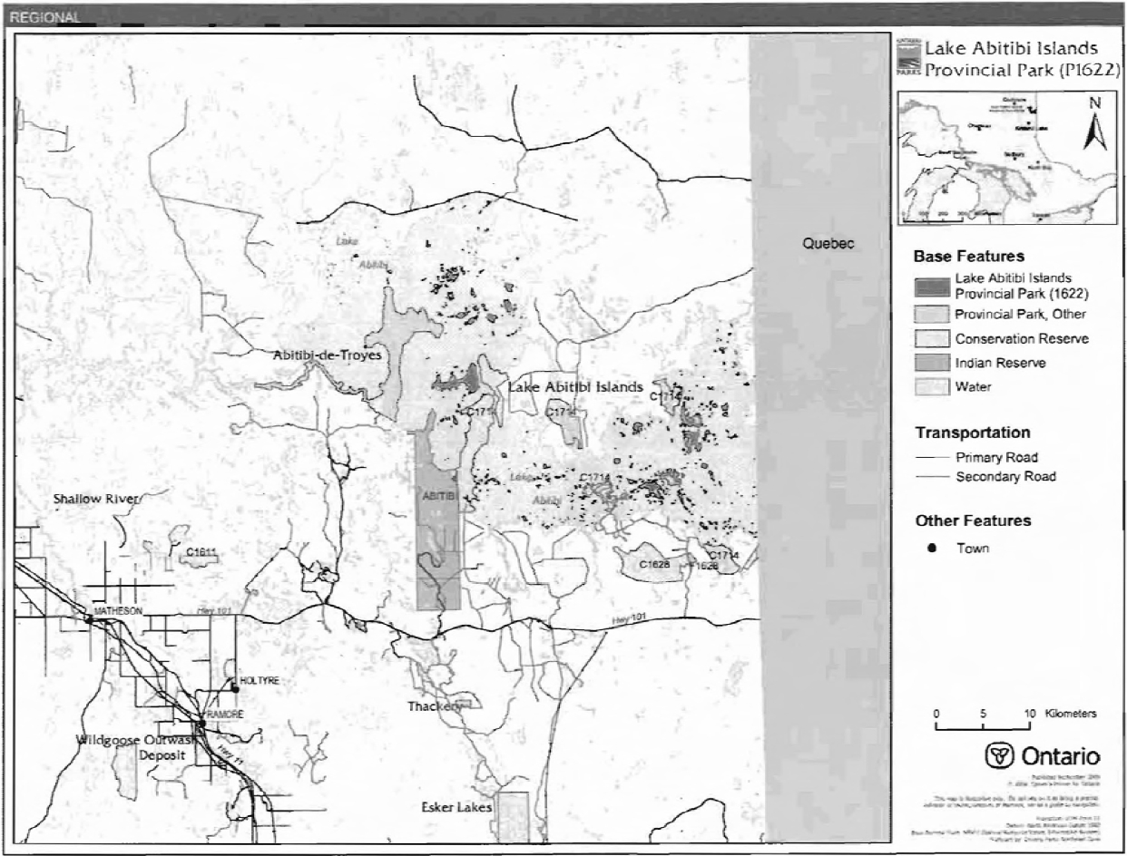
Lake Abitibi Islands Provincial Park is located in Lake Abitibi in northeastern Ontario. The park is 2,721 hectares in size and incorporates 786 islands. The islands range in size from tiny shoals and islets to large islands of up to 550 hectares. The nearest community is the town of Iroquois Falls which is about 40 kilometres to the west. The park is in Berry, Steele, Stoughton, Frecheville, Lamplugh and Rand townships as well as in unsurveyed territory.
The islands provide important waterfowl staging and nesting areas as well as nesting habitat for osprey, bald eagles, cormorants and great blue herons. Also associated with the islands are spawning areas for many fish species.
1.1 Objectives
Lake Abitibi Islands Provincial Park will be managed consistent with the two main objectives for nature reserve class provincial parks:
Protection: To protect provincially significant elements of the natural and cultural landscapes of Ontario.
Heritage Appreciation: To provide opportunities for exploration and appreciation of the outdoor natural and cultural heritage of Ontario.
2.0 Management context
The purpose of this Interim Management Statement (IMS) is to provide direction to ensure the custodial management of park resources. Future park planning may be undertaken as required to provide direction on significant decisions regarding resource stewardship, development, operations, and permitted uses.
Park management will follow direction from:
- Provincial Parks Act (1990) and regulations
- Ontario Provincial Parks Planning and Management Policies (OMNR 1992)
- Crown Land Use Policy Atlas (OMNR 2004a)
- Ontario’s Living Legacy Land Use Strategy (OMNR 1999) and policy clarifications (OMNR 2000), amendments, and related direction
In addressing custodial management obligations to protect park values and ensure public health and safety, Ontario Parks will ensure that policy and Environmental Assessment Act (1990) requirements are implemented.
Figure 1 - Regional Setting

Enlarge Figure 1 - Regional Setting Map.
Figure 2 - Park Boundary (west section)
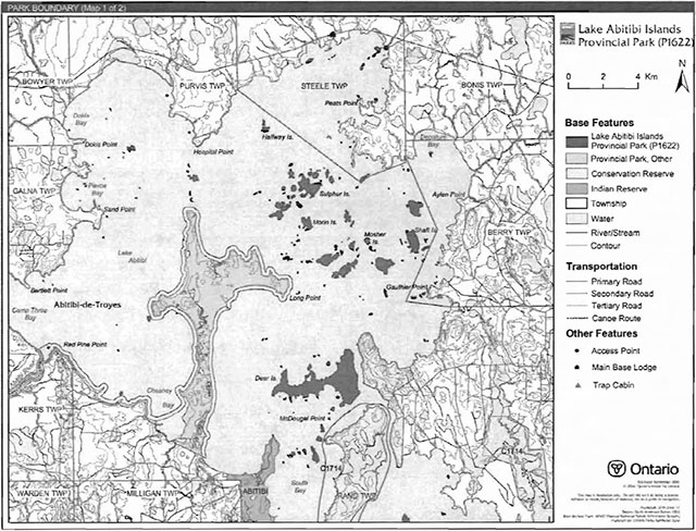
Enlarge Figure 2 - Park Boundary (west section).
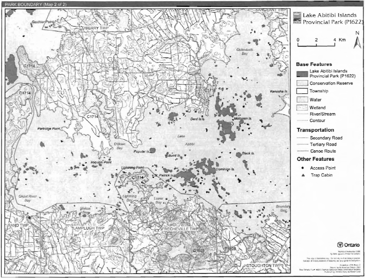
Figure 2 - Park Boundary (east section)
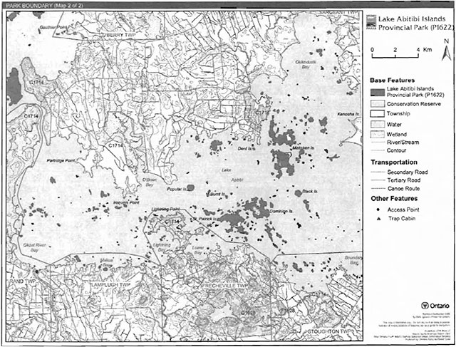
Enlarge Figure 2 - Park Boundary (east section).
2.1 Environmental Assessment
As part of the Ontario Ministry of Natural Resources (MNR), Ontario Parks is a public sector agency that is subject to the Environmental Assessment Act. Park management will be carried out in accordance with legislation, policies and guidelines as required under MNR's A Class Environmental Assessment for Provincial Parks and Conservation Reserves (OMNR 2005).
3.0 Park features and values
The Lake Abitibi Islands Provincial Park incorporates 786 islands covering 2,721 hectares on Lake Abitibi.
3.1 Geological features
The islands of Lake Abitibi Islands Provincial Park are predominantly underlain by granitic, volcanic and sedimentary rocks of the Archean age Abitibi Subprovince of the Superior Province. The Archean rocks, in this case granitic rocks of the Abitibi batholith, volcanic rocks of the Staughton-Roquemaure assemblage and sedimentary rocks of the Scapa assemblage, are considered to be of at least regional significance.
The surficial geology of Lake Abitibi Islands Provincial Park shows quaternary deposits of glaciolacustrine clays and silts of Pleistocene, Wisconsinan age, laid down in glacial lakes Ojibway and Barlow. These deposits are part of the Great Clay Belt that stretches from the west of the city of Timmins into the province of Quebec.
3.2 Biological features
The Islands of Lake Abitibi provide important nesting habitat for many species of birds. Great blue heron, bald eagles, osprey and double-crested cormorants are just a few of the species that nest or feed in and around the Lake Abitibi Islands.
The islands of Lake Abitibi support intolerant hardwood and mixedwood forests. Black spruce, white spruce and white birch are common tree species. It is possible that ancient eastern white cedar are present on some of the islands in the park (Harper 2003). Large cedar have been observed on some of the islands.
3.3 Cultural setting
A cultural heritage investigation of Lake Abitibi Islands Provincial Park has not been completed.
Any future planning will be within the context of a provincial framework, A Topical Organization of Ontario History (OMNR 1974). In addition, updates and discussions with First Nations, other agencies and stakeholders may be carried out to identify cultural heritage values and features within the park and their significance. This information may be used to develop management guidelines to conserve and protect representative archaeological and historical values and features, or to provide direction for further research.
3.4 Recreation
The recreation uses of Lake Abitibi Islands Provincial Park have been limited to camping associated with sport fishing and recreational boating on Lake Abitibi.
The park could also be utilized for other recreational activities such as landscape/wildlife viewing.
4.0 Aboriginal uses
Lake Abitibi Islands Provincial Park lies within the 1905 AE treaty boundary. The nearest First Nation is Wahgoshig First Nation. The Wahgoshig First Nation Reserve is on the southwestern side of Lake Abitibi.
First Nations have expressed interest in and have shared knowledge of the park and surrounding area. Aboriginal communities have used the area for hunting, trapping, fishing, gathering and travel. These uses may continue, subject to public safety, conservation and other considerations.
Any communications and cooperation between Aboriginal communities and the MNR for planning and operations purposes will be done without prejudice to any future discussions or negotiations between the government of Ontario and Aboriginal communities.
5.0 Stewardship policies
Non-native species will not be deliberately introduced into the park. Where non-native species are already established and threaten park values (i.e., has become invasive), a strategy to control the species may be developed (OMNR 1992).
The removal, damage or defacing of Crown property, natural objects, relics and artefacts is not permitted in provincial parks (Provincial Parks Act).
5.1 Terrestrial ecosystems
5.1.1 Harvesting
Commercial forest operations and renewal activities are not permitted within the park (OMNR 1992).
The harvest of non-timber forest products, such as club moss and Canada yew, will not be permitted (OMNR 1992).
Existing authorized wild rice harvesting may continue. New operations will not be permitted.
There are no fuelwood cutting permits currently issued for the park. New permits will not be issued (OMNR 2000).
5.1.2 Insects and disease
Insects and diseases may be managed where the aesthetic, cultural, or natural values of the park are threatened (OMNR 1992). Control measures will follow guidelines established by the Ontario Ministry of the Environment (MOE) and MNR. Whenever possible, biological control measures will be given preference over the use of chemicals (OMNR 1992).
5.1.3 Fire
Lake Abitibi Islands Provincial Park is located within the Boreal Fire Management Zone. In accordance with existing provincial park policy and the Forest Fire Management Strategy for Ontario, forest fire protection will be carried out in the park as on surrounding lands. Whenever feasible, MNR's Forest Fire Management program will use techniques that minimize damage to the landscape, such as limiting the use of heavy equipment or limiting the number of trees felled during response efforts (OMNR 2004b).
5.1.4 Wildlife management
Lake Abitibi Islands Provincial Park is located within Wildlife Management Unit 27. The removal or harassment of non-game animals is not permitted (Provincial Parks Act).
Hunting
Sport hunting is not permitted. There will be education efforts regionally to identify the extent of the nature reserve and the prohibition of hunting.
Trapping
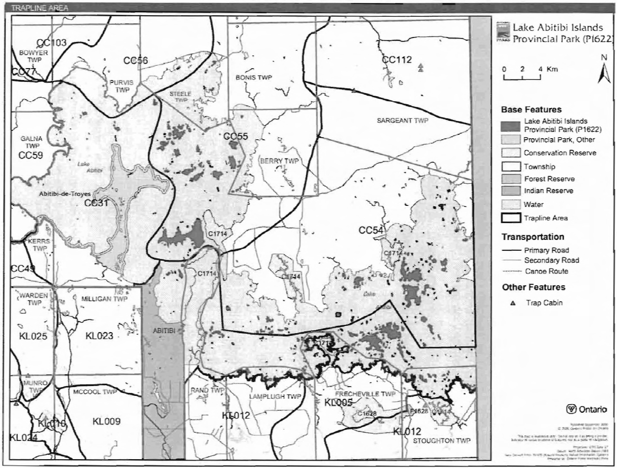
There are portions of four licensed trap lines which are included in the area of this park: CC31, CCS4, CCSS, COS6 (Figure 3).
Trapping in this OLL nature reserve class park is not a permitted use (OMNR 1999, 2000). However, Status Indians exercising treaty rights are permitted to continue commercial fur harvesting in all parks. The transfer of trap lines in nature reserve class parks inside the OLL planning area will be permitted only between Status Indians (OMNR 2000).
Commercial fur harvesting by persons other than Status Indians will be phased out of this nature reserve park by December 31, 2009 (OMNR 1992, 2000, 2004). No new operations, including trap line cabins and trails, will be permitted (OMNR 2003).
5.1.5 Industrial resources
There are no existing mining claims within the park. The mining and surface rights on all lands within the park have been withdrawn from staking under the Mining Act (1990). Mineral exploration and mining are not permitted within the park.
5.1.6 Access and crossings
Access
The park is accessible by water only.
Lake Abitibi is accessible on its north side at an access point on Northeast Bay, near Eades on the Canadian National Railway. This access point is accessible by a secondary road branching from a primary road to the north. A second access point is directly south on the southern shore of Lake Abitibi on Ghost River Bay at the mouth of the Ghost River. This access point is accessible by a secondary road branching from Highway 101 to the south (Harper 2003). Lake Abitibi is also accessible from the Abitibi River. Twin Falls Marina is located approximately 38 kilometres from Lake Abitibi on the Abitibi River.
Recreational trails
Canoe Route: Lake Abitibi and the Abitibi River were part of a traditional canoe route for fur traders and natives. Access and hazardous conditions limit canoeing on Lake Abitibi.
Other Trails: There are currently no other authorized recreational trails within the park boundary. New trails (e.g., hiking) may be developed if the need arises. Any proposed development within the park is subject to Environmental Assessment Act requirements.
Figure 3 - Trap Line Areas
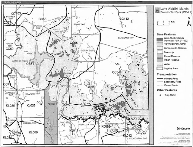
Enlarge Figure 3 - Trap Line Areas.
5.1.7 Adjacent land management
Forestry
Lake Abitibi Islands Provincial Park is surrounded by the Iroquois Falls Forest Management Unit (#012). This unit is managed according to the 2005-2025 Forest Management Plan for Iroquois Falls Forest which includes forest harvesting and renewal operations.
Conservation Reserves
There are two conservation reserves (CR) in the immediate vicinity of the Lake Abitibi Islands Provincial Park. They are McDougal Point Peninsula CR, and the Trollops Lake Burnt Hill Poplar Spruce CR.
Provincial Parks
Provincial Parks near the Lake Abitibi Islands Provincial Park include Abitibi De Troyes and Thackeray.
5.1.8 Land disposition
New land disposition for the private use of individuals or corporations will not be permitted (OMNR 1992; 2000).
Land Use Permits, licenses of occupation, and unauthorized occupations
There are no Land Use Permits (LUP) within the park.
There are no known licensed occupations within the park.
There are suspected unauthorized occupations (UOs) on several of the islands within the park; however information regarding the location and purpose of these occupations is not readily available. The unauthorized occupations will be dealt with by enforcement officers. New unauthorized occupations will be dealt with as they are discovered.
Patent land
Private lands are not included in the park and, as such, the policies and legislation of the Provincial Parks Act do not apply.
Boat caches
There are no known authorized boat caches located within the boundary of Lake Abitibi Islands Provincial Park. Boats are not permitted to be left unattended in the park without written permission from the superintendent under the authority of the Provincial Parks Act.
5.2 Aquatic ecosystems
Sustaining quality water resources is integral to the protection of park and adjacent land values. The MOE enforces applicable legislation and regulations for water quality.
5.2.1 Water management
The Twin Falls Dam on the Abitibi River is outside of the park but influences water levels on Lake Abitibi. The dam is owned and operated by Abitibi Consolidated Inc.
New commercial hydroelectric development will not be permitted in the park (OMNR 2000).
5.2.2 Fisheries management
Fisheries management will complement the maintenance and enhancement of native, self-sustaining fish populations. Non-native fish will not be deliberately introduced in the waters contained in this park (OMNR 1992).
Sport fishing
Sport fishing is permitted within the park. This activity is governed by legislation and regulations in the Fish and Wildlife Conservation Act (1997) and the Fisheries Act (1985). The Recreational Fishing Regulations Summary contains details on regulations which are applicable to this area.
Commercial fishing
There are no commercial fishing operations within Lake Abitibi Islands Provincial Park. New operations will not be permitted (OMNR 2000).
Commercial baitfish harvesting
There are no commercial baitfish harvesting licenses allocated in Lake Abitibi Islands Provincial Park.
Fish stocking
The stocking of native fish species may be considered through park management planning, with full public and Aboriginal consultation. Non-native fish species will not be deliberately introduced into park waters (OMNR 1992).
6.0 Operations policies
6.1 Recreation management
Future planning with full public and Aboriginal consultation will review direction on motorized and non-motorized recreation activities.
6.1.1 Motorized recreation
Motorboats
The use of motorboats is permitted to continue, unless park values are threatened (OMNR 2004a).
Aircraft
Aircraft landings are not permitted in the park (OMNR 2004a).
Snowmobiles
Snowmobile use on established routes for recreational ice fishing may be permitted to continue unless such trails threaten park features and values, create user conflicts or raise safety/liability issues.
Proposals for new trails may only be considered through future planning with public and Aboriginal consultation (OMNR 2000).
Off-trail snowmobile use is not permitted.
6.1.2 Non-motorized recreation
Camping
There are no managed campsites within Lake Abitibi Islands Provincial Park. However, there are a number of existing sites where recreational users have traditionally camped.
Camping can be prohibited under the Provincial Parks Act (RSO 1990) to protect natural heritage features and values within a nature reserve class park. However, existing use may be evaluated and sites that do not affect natural heritage features and values may be allowed to continue as a non-conforming use, subject to future planning. Existing campsites that are found to negatively affect park values will be closed. Camping use will be reviewed during future planning with full public and Aboriginal consultation.
Hiking
There are no developed hiking trails within this park.
If there is an identified need, the development of new hiking trails may be considered. Trail infrastructure to protect park values and features will be permitted. Any proposed development within the park is subject to Environmental Assessment Act requirements.
Canoeing/kayaking
Existing uses may continue, unless park values are threatened (OMNR 2004a). Infrastructure to protect park features and values may be permitted and developed in response to use, environmental deterioration, and environmental protection requirements.
6.1.3 Emerging recreational uses
There are emerging recreational uses for which there is limited or no policy to deal with their management (e.g., adventure racing, geocaching). The park superintendent will use legislation, policy and guidelines that are in place in the interim to manage emerging uses.
6.2 Development
There is no existing park infrastructure located within the park. Infrastructure to protect park features and values may be permitted and developed in response to use, environmental deterioration, and environmental protection requirements. Any proposed development within the park is subject to the Environmental Assessment Act.
7.0 Cultural resources
An assessment of the cultural resources specific to Lake Abitibi Islands Provincial Park has not yet been completed. The management of any cultural values within this park will be directed toward protection and heritage appreciation (OMNR 1992).
8.0 Heritage education
Literature and other supporting information may be developed to describe the park in the context of Ontario’s provincial park system. Boundary limits, significant heritage features and permitted uses of the waterway park may be included in park literature.
Prospective park visitors may be informed about the sensitivity and significance of park values through park literature.
9.0 Research
Scientific research by qualified individuals which contributes to the knowledge of natural or cultural history, or to environmental or recreational management, may be encouraged in the park. Ontario Parks will encourage institutions, such as universities, to undertake research project.
All research programs will require the approval of Ontario Parks and are subject to park policy and other applicable legislation. Any materials removed from the park will remain the property of Ontario Parks.
Approved research activities and facilities will be compatible with the park’s protection objective. Any site which is affected by research will be rehabilitated as closely as possible to its original state. Environmental Assessment Act requirements will apply.
10.0 References
Canadian Environmental Protection Act, 1999.
Environmental Assessment Act, 1990.
Fisheries Act, 1985.
Fish and Wildlife Conservation Act, 1997.
Frey, E. and D. Duba., 2002. Earth Science Checksheet-P128 West Montreal River Provincial Park. Ontario Ministry of Natural Resources (OMNR).
Harper, T., 2003. Lake Abitibi Islands Provincial Park P1622 Recreation Inventory Report Version 1.1. OMNR
Migratory Birds Convention Act, 1994.
Mining Act, 1990.
Morris, E. R., 2002. Natural Heritage Area Life Science Checksheet West Montreal River (OLL pp 128). OMNR
OMNR, 1974. A Topical Organization of Ontario History. Historic Sites Branch Division of Parks.
OMNR,1992. Ontario Provincial Parks Planning and Management Policies.
OMNR, 1999. Ontario’s Living Legacy Land Use Strategy.
OMNR, 2000. Ontario’s Living Legacy Land Use Strategy (Policy Clarification).
OMNR, 2003a. Public and Aboriginal Consultation Document Form Ontario’s Living Legacy Protected Area Boundary Refinement Review: West Montreal River Provincial Park (pp128).
OMNR, 2003b. Directions for Commercial Resource Use Activities in Provincial Parks and Conservation Reserves. 5 pp.
OMNR, 2004a. Crown Land Use Policy Atlas.
OMNR, 2004b. Forest Fire Management Strategy for Ontario. Aviation and Fire Management Branch.
OMNR, 2005. A Class Environmental Assessment for Provincial Parks and Conservation Reserves.
Pesticides Act, 1990.
Provincial Parks Act, 1990.
11.0 Appendix A: Background information
| Name | Lake Abitibi Islands (P1715) |
|---|---|
| Classification | Nature Reserve |
| Ecoregion/Ecodistrict | 3E-6, 3E-1 |
| OMNR Administrative Region/District | Northeast Region - Cochrane |
| Total Area (ha) | 2, 721 |
| Regulation date & Number for Park | May 2005 (O.Reg.#180/05) |
Detailed information for site P1622 Lake Abitibi Islands
Protection History
The site was identified under the provincial Lands for Life - Ontario’s Living Legacy Program as containing "the islands of Lake Abitibi which provide important waterfowl and heron nesting sites." (OMNR 1999).
Setting
The park incorporates all 786 islands on Lake Abitibi, comprising 547 hectares of Crown land. The reserve is located approximately 70 kilometres east of the Town of Cochrane and 40 kilometres east of the Town of Iroquois Falls. The part of Lake Abitibi in Ontario is naturally divided into to two more or less equal portions, a northwest portion and a southeast portion, separated by The Narrows, a channel at McDougal Point and Deer Island. The site lies within Cochrane MNR District, and comprises 2, 721 hectares taking into account lake waters. Elevations range from 868± ft above sea level (a.s.l.) at Lake Abitibi Lake level to >950 m a.s.l. on a number of the larger islands.
Earth science features
Bedrock geology
The islands of Lake Abitibi Islands Provincial Park are predominantly underlain by granitic, volcanic and sedimentary rocks of the Archean age Abitibi Subprovince of the Superior Province. Proterozoic age diabase dikes (Osmani 1991) that cross-cut the Archean rocks occur on a few islands. The park is located in the east central part of the Ontario portion of the Abitibi greenstone belt, marginal to and including a small portion of the Lake Abitibi granitic batholith. Volcanic and sedimentary sequences in the Ontario portion of the Abitibi greenstone belt have been assigned to a number of tectonic assemblages: two are represented in the islands, the Stoughton-Roquemaure assemblage and the Scapa assemblage (Frey and Duba 2002).
The southeast portion of Lake Abitibi in Ontario, east of The Narrows, was included in mapping at detailed, 1:15 840 scale, resulting in a compilation at a scale of 1:63 360. No recent geological mapping by government surveys of the islands in the northwest portion of the lake, to the west of The Narrows, has been published. Mapping of adjacent townships of Steele, Bonis and Scapa throws some light on the geology of this northwest portion of the lake. All this mapping has been more recently compiled into a regional map of the major part of the Ontario portion of the Abitibi greenstone belt at 1:100 000 scale (Frey and Duba 2002).
The islands in the northwest portion of Lake Abitibi are underlain by rocks of the greenstone belt, except for a few islands in the east that are underlain by rocks of the Abitibi batholith. The greenstones in turn are almost entirely volcanic rocks of the Stoughton-Roquemaure assemblage. A major northeast-trending fault at the north end of the lake separates the Stoughton-Roquemaure from the Scapa assemblage. The latter assemblage is dominantly comprised of sedimentary rocks. It underlies seven very small islands in Northwest Bay, and one island in Northeast Bay. None of the islands were visited thus it is not known if there are any bedrock outcrops on them. Scapa assemblage rocks in this very small portion of the assemblage are likely sandstones of turbidite origin, though some conglomerate may be present since Lumbers (1962) noted layers of this rock type along the shoreline of Lake Abitibi in this area (Frey and Duba 2002).
To the south of the major fault, volcanic rock units of the Stoughton-Roquemaure assemblage in this northwest portion of the lake strike in a northeasterly direction. They are dominantly mafic flow rocks intruded by subvolcanic mafic and ultramafic sills. A unit of intermediate to felsic flow rocks underlies islands in the centre of the lake, grouped around Sulphur Island and Morin Island, while those to the south of them, between Mosher Island and Long Point, are comprised of the more dominant mafic flow rocks. All but the southeast corner of Deer Island, adjacent to The Narrows, is underlain by mafic volcanic flow rocks. During the present inventory, only one helicopter landing (station 1) was made in the park, due to inclement weather. This station was on a small island immediately adjacent to the southwest side of Morin Island. Here altered volcanic rocks, probably of intermediate composition, were intruded by quartz veins. Small pits that had been opened up on the veins provided evidence of mineral exploration (photo 1). Minor amounts of pyrite were seen in the quartz and in the surrounding volcanic rock (Frey and Duba 2002).
The islands in the southeast portion of Lake Abitibi are underlain almost equally by rocks of the greenstone belt, and by rocks of the Abitibi batholith. None of the islands in this portion were visited during this present helicopter-facilitated inventory, due to inclement weather. The greenstones are entirely volcanic rocks of the Stoughton-Roquemaure assemblage, and occur on the more southerly islands (St. Patrick, Dominion, Black, and adjacent islands). Although folded in detail, rock units strike in a general east-west direction. They are dominantly mafic flow rocks, mostly of tholeiitic affinity, but some are komatiitic (Frey and Duba 2002).
Granitic rocks of the Abitibi batholith occur on the more northerly islands in this southeast portion of the lake (Poplar, Burnt, Mistaken, Kenosha, and adjacent islands). The intrusive contact between the rocks of the batholith and the greenstones is a sinuous but predominantly east trending line that mostly lies beneath the waters of the lake. However, it passes through a number of islands and headlands, including from west to east Partridge Point, an island west of Iroquois Point, Iroquois Point, Lightning Point, an island northwest of St. Patrick Island, the southern island of the Mistaken Islands, and a number of smaller islands east of them. Rocks of the batholith belong to a number of granitic phases that vary from massive to gneissic in texture, but are predominantly trondhjemites in composition. In the northwest portion of the lake, a more mafic phase of the batholith, of dioritic composition, occurs on an island south of Departure Bay and west of Aylen Point (Frey and Duba 2002).
Proterozoic age diabase occurs on a number of islands as parts of regionally extensive, northeast-trending dikes that belong to the Abitibi swarm. Four such major dikes that extend southwestward across the Abitibi greenstone belt and to the northeast into Quebec cross the park area. Two of the dikes are represented on islands, one in the northwest portion of the lake on Gauthier Point and islands that extend southwest from the point. The other occurs in the southeast portion of the lake at two places, one on an island at its west end, the other on an island in Okikodosik Bay (Frey and Duba 2002).
Surficial geology
Quaternary deposits are glaciolacustrine clays and silts of Pleistocene. Wisconsinan age, laid down in glacial lakes Ojibway and Barlow. They are part of the "Great Clay Belt" that has been mapped from west of Timmins eastward into Quebec. Mapping of the southeastern portion of the lake and surrounding area shows the distribution of clay and bedrock outcrops, making it quite clear that clay predominates as a thick blanket: from the south shore northward the ratio of clay and lake to bedrock outcrop is about 20:1. Engineering geology maps also show this distribution of glaciolacustrine deposits (Frey and Duba 2002).
A number of very long esker ridges and trains fan out across northeast Ontario southward from the James Bay lowlands into Sudbury and Timiskaming Districts. One of these underlies the long, narrow peninsula of Long Point extending from the south shore of the northwest portion of Lake Abitibi. Although insignificant on Lake Abitibi islands, a small remnant of one of the eskers is shown on Map 2651 on an island lying between the Mistaken Islands and Kenosha Island in the northeast part of the southeastern portion of the lake (Frey and Duba 2002).
Significance
Significance is assigned here with regard to the objectives of the earth science conservation program, as generally expressed in the Earth Science Framework document (Davidson 1981).
Lake Abitibi Islands Provincial Park is one of the few protected areas in the Ontario Parks system that incorporates rocks of the Abitibi greenstone belt, and in particular the major central portion (the western portion, which includes the Swayze and Belford-Strachan greenstone belts gets better representation). For this reason alone, any representation of Archean rocks is of considerable significance to the conservation program. Archean rocks, in this case granitic rocks of the Abitibi batholith, volcanic rocks of the Staughton-Roquemaure assemblage and sedimentary rocks of the Scapa assemblage, are considered to be of at least regional significance. They may be of greater significance, but comparison with those in other protected areas would have to be made to justify raising to provincial status.
Quaternary glaciolacustrine deposits are representative of the "Great Clay Belt", and are at least regionally significant.They may be of greater significance, but comparison with those in other protected areas would have to be made to justify raising to provincial status. The esker remnant in the southeastern portion of the lake is insignificant to the earth science conservation program.
Life science features
The majority of the 786 islets and islands in Lake Abitibi are small, wave-washed bedrock outcrops. Larger islands may retain a cover of glaciolacustrine sediment. The shores of the islands may be surrounded by smaller, rounded boulders of country rock and occasional glacial drop stones. Some of these bedrock dome islands have been sculpted by glaciers into classic roche-montane.
The islands range in size from tiny shoals and islets to approximately 550 ha (Deer Island). Many of the smallest islets are essentially free of vegetation, while large islands may support several intolerant hardwood-mixedwoods vegetation types.
- Mixed coniferous forests-B, Sb, Sw
- Mixed IH forests-mainly Bw
The islands have not been logged recently, nor have there been significant impact from mineral exploration. There have been no cottage developments on the islands. Winter recreation and traditional uses have affected some islands-cleared campsites, non-biodegradeable refuse-but these impacts are local, thanks in part to the remoteness of the site and enforcement of unauthorized occupations by MNR conservation officers.
The overall condition of the islands is excellent. Alien species are infrequently seen (Morris 2002).
Cultural resources:
There has been no examination or documentation of cultural values that may exist within Lake Abitibi Islands Provincial Park.
Recreation & tourism:
This park is a nature reserve class which protects representative natural areas within the southern Boreal forest and Lake Abitibi. Potential recreational activities in this park include nature study, exploring, boating and canoeing-travel on this lake can be hazardous due to changeable lake conditions caused by weather (Harper 2003).
Inventories
| Survey Level | Earth Science | Life Science | Cultural | Recreational |
|---|---|---|---|---|
| Reconnaissance | Frey and Duba, 2002 | Morris, 2002 | Harper, 2003 |