Lowland Toothcup Recovery Strategy
This document is the recovery strategy for Lowland Toothcup, a species of plant at risk in Ontario.
Cover photo: Sam Brinker
About the Ontario recovery strategy series
This series presents the collection of recovery strategies that are prepared or adopted as advice to the Province of Ontario on the recommended approach to recover species at risk. The Province ensures the preparation of recovery strategies to meet its commitments to recover species at risk under the Endangered Species Act, 2007 (ESA) and the Accord for the Protection of Species at Risk in Canada.
What is recovery?
Recovery of species at risk is the process by which the decline of an endangered, threatened, or extirpated species is arrested or reversed, and threats are removed or reduced to improve the likelihood of a species' persistence in the wild.
What is a recovery strategy?
Under the ESA a recovery strategy provides the best available scientific knowledge on what is required to achieve recovery of a species. A recovery strategy outlines the habitat needs and the threats to the survival and recovery of the species. It also makes recommendations on the objectives for protection and recovery, the approaches to achieve those objectives, and the area that should be considered in the development of a habitat regulation. Sections 11 to 15 of the ESA outline the required content and timelines for developing recovery strategies published in this series.
Recovery strategies are required to be prepared for endangered and threatened species within one or two years respectively of the species being added to the Species at Risk in Ontario list. Recovery strategies are required to be prepared for extirpated species only if reintroduction is considered feasible.
What’s next?
Nine months after the completion of a recovery strategy a government response statement will be published which summarizes the actions that the Government of Ontario intends to take in response to the strategy. The implementation of recovery strategies depends on the continued cooperation and actions of government agencies, individuals, communities, land users, and conservationists.
For more information
To learn more about species at risk recovery in Ontario, please visit the Ministry of Natural Resources and Forestry Species at Risk webpage.
Recommended citation
Ontario Ministry of Natural Resources and Forestry. 2016. Recovery Strategy for the Lowland Toothcup (Rotala ramosior) in Ontario. Ontario Recovery Strategy Series. Prepared by the Ontario Ministry of Natural Resources and Forestry, Peterborough, Ontario. iv + 6 pp. + Appendix 20 pp. + Annex. Adoption of Recovery Strategy for the Toothcup (Rotala ramosior) in Canada. (Environment Canada 2015).
© Queen’s Printer for Ontario, 2016
ISBN 978-1-4606-7679-0 (HTML)
ISBN 978-1-4606-7688-2 (PDF)
Content (excluding the cover illustration) may be used without permission, with appropriate credit to the source.
Cette publication hautement spécialisée « Recovery strategies prepared under the Endangered Species Act, 2007 », n'est disponible qu'en anglais en vertu du Règlement 411/97 qui en exempte l'application de la Loi sur les services en français. Pour obtenir de l'aide en français, veuillez communiquer avec recovery.planning@ontario.ca.
Declaration
The recovery strategy for the Lowland Toothcup was developed in accordance with the requirements of the Endangered Species Act, 2007 (ESA). This recovery strategy has been prepared as advice to the Government of Ontario, other responsible jurisdictions and the many different constituencies that may be involved in recovering the species.
The recovery strategy does not necessarily represent the views of all of the individuals who provided advice or contributed to its preparation, or the official positions of the organizations with which the individuals are associated.
The goals, objectives and recovery approaches identified in the strategy are based on the best available knowledge and are subject to revision as new information becomes available. Implementation of this strategy is subject to appropriations, priorities and budgetary constraints of the participating jurisdictions and organizations.
Success in the recovery of this species depends on the commitment and cooperation of many different constituencies that will be involved in implementing the directions set out in this strategy.
Responsible jurisdictions
Ontario Ministry of Natural Resources and Forestry
Environment and Climate Change Canada – Canadian Wildlife Service, Ontario
Parks Canada Agency
Executive summary
Executive summary of Ontario’s recovery strategy
The Endangered Species Act, 2007(ESA) requires the Minister of Natural Resources and Forestry to ensure recovery strategies are prepared for all species listed as endangered or threatened on the Species at Risk in Ontario (SARO) List. Under the ESA, a recovery strategy may incorporate all or part of an existing plan that relates to the species.
The Lowland Toothcup (Rotala ramosior) is listed as endangered on the SARO List. The species is also listed as endangered under the federal Species at Risk Act (SARA). Environment Canada adopted the "Recovery Strategy for the toothcup (Rotala ramosior) in British Columbia and Ontario" (Part 2), included an addition (Part 1) to meet its requirements under SARA, and published the federal strategy entitled "Recovery Strategy for the Toothcup (Rotala ramosior) in Canada" in 2015. The federal recovery strategy is hereby adopted under the ESA. With the additions indicated below, the enclosed strategy meets all of the content requirements outlined in the ESA.
The federal recovery strategy refers to only a single population; however, two populations for Toothcup are described in a new COSEWIC status report: the Great Lakes Plains population in Ontario and the Southern Mountain population in British Columbia.
Being an annual plant that is reliant on dynamic flood regimes, population numbers of Lowland Toothcup can fluctuate widely from year to year. This has been observed for the Sheffield – Long Lake / Claire River subpopulation. No large fluctuations have been observed for the Puzzle Lake subpopulation.
The new COSEWIC status report provides some additional information on threats. Shoreline disturbance and human activities associated with waterfront development and recreation are considered to be the most immediate threats.
The Critical Habitat section of the federal recovery strategy provides an identification of critical habitat (as defined under the SARA). Identification of critical habitat is not a component of a recovery strategy prepared under the ESA. However, it is recommended that the approach used to identify critical habitat in the federal recovery strategy be considered when developing a habitat regulation under the ESA.
Adoption of federal recovery strategy
The Endangered Species Act, 2007(ESA) requires the Minister of Natural Resources and Forestry to ensure recovery strategies are prepared for all species listed as endangered or threatened on the Species at Risk in Ontario (SARO) List. Under the ESA, a recovery strategy may incorporate all or part of an existing plan that relates to the species.
The Lowland Toothcup (Rotala ramosior) is listed as endangered on the SARO List. The species is also listed as endangered under the federal Species at Risk Act (SARA). Environment Canada adopted the "Recovery Strategy for the toothcup (Rotala ramosior) in British Columbia and Ontario" (Part 2), included an addition (Part 1) to meet its requirements under SARA, and published the federal strategy entitled "Recovery Strategy for the Toothcup (Rotala ramosior) in Canada" in 2015. The federal recovery strategy is hereby adopted under the ESA. With the additions indicated below, the enclosed strategy meets all of the content requirements outlined in the ESA.
Species assessment and classification
Table 1. Species assessment and classification of the Lowland Toothcup (Rotala ramosior). The glossary provides definitions for the abbreviations within, and for other technical terms in this document
|
Assessment |
Status |
|---|---|
|
SARO list classification |
Endangered |
|
SARO list history |
Endangered (2008), Endangered – Not regulated (2004) |
|
COSEWIC assessment history |
Toothcup (Great Lakes Plains population) – Threatened (2014) Toothcup – Endangered (2000, 1999) |
|
SARA schedule 1 |
Endangered (2003) |
|
Conservation status rankings |
GRANK: G5 NRANK: N1N2 SRANK: S1 |
Species description
The federal recovery strategy refers to only a single designatable unit (DU) or population; however two designatable units or populations for Toothcup are described in the new status report (COSEWIC 2015). These are the Great Lakes Plains designatable unit in Ontario and the Southern Mountain designatable unit in British Columbia. The Great Lakes Plains DU includes the extirpated Rotala Field subpopulation in Norfolk County and the Puzzle Lake and Sheffield – Long Lake / Claire River subpopulations. The latter two subpopulations technically occur in the Boreal Ecozone, but, because of their proximity to the Great Lakes Plains Ecozone and because Toothcup is not a boreal species, they are included in the Great Lakes Plains DU.
Being an annual plant that is reliant on dynamic flood regimes, population numbers of Lowland Toothcup can fluctuate widely from year to year. This has been observed for the Sheffield – Long Lake / Claire River subpopulation. At one particular site, there were 1,000 – 3,000 plants in 2004; in 2011, no plants were observed. At another site, 1,400 plants were counted in 2004; only 305 were counted in 2011. No large fluctuations have been observed for the Puzzle Lake subpopulation.
Threats to survival and recovery
COSEWIC (2014) provided additional information on threats which were identified in the federal recovery strategy. Shoreline disturbance and human activities associated with waterfront development and recreation are considered to be the most immediate threats to Lowland Toothcup in the Puzzle Lake and Sheffield – Long Lake areas. Current impacts at Puzzle Lake and Sheffield – Long Lake / Claire River appear to be minor; however there is the potential for ongoing long term impacts.
Limited backcountry campsite development within Puzzle Lake Provincial Park may occur that could slightly reduce the amount of potential suitable habitat. Given this possibility, the presence of any existing occupied Lowland Toothcup habitat will be considered in future management decisions regarding campsite development (COSEWIC 2014).
Area for consideration in developing a habitat regulation
Under the ESA, a recovery strategy must include a recommendation to the Minister of Natural Resources and Forestry on the area that should be considered in developing a habitat regulation. A habitat regulation is a legal instrument that prescribes an area that will be protected as the habitat of the species. The recommendation provided below will be one of many sources considered by the Minister, including information that may become newly available following completion of the recovery strategy, when developing the habitat regulation for this species.
The Critical Habitat section of the federal recovery strategy provides an identification of critical habitat (as defined under the SARA). Identification of critical habitat is not a component of a recovery strategy prepared under the ESA. However, it is recommended that the approach used to identify critical habitat in the federal recovery strategy be considered when developing a habitat regulation under the ESA.
Glossary
Committee on the Status of Endangered Wildlife in Canada (COSEWIC): The committee established under section 14 of the Species at Risk Act that is responsible for assessing and classifying species at risk in Canada.
Committee on the Status of Species at Risk in Ontario (COSSARO): The committee established under section 3 of the Endangered Species Act, 2007 that is responsible for assessing and classifying species at risk in Ontario.
Conservation status rank: A rank assigned to a species or ecological community that primarily conveys the degree of rarity of the species or community at the global (G), national (N) or subnational (S) level. These ranks, termed G-rank, N-rank and S-rank, are not legal designations. Ranks are determined by NatureServe and, in the case of Ontario’s S-rank, by Ontario’s Natural Heritage Information Centre. The conservation status of a species or ecosystem is designated by a number from 1 to 5, preceded by the letter G, N or S reflecting the appropriate geographic scale of the assessment. The numbers mean the following:
1 = critically imperilled
2 = imperilled
3 = vulnerable
4 = apparently secure
5 = secure
NR = not yet ranked
Endangered Species Act, 2007 (ESA): The provincial legislation that provides protection to species at risk in Ontario.
Species at Risk Act (SARA): The federal legislation that provides protection to species at risk in Canada. This act establishes Schedule 1 as the legal list of wildlife species at risk. Schedules 2 and 3 contain lists of species that at the time the Act came into force needed to be reassessed. After species on Schedule 2 and 3 are reassessed and found to be at risk, they undergo the SARA listing process to be included in Schedule 1.
Species at Risk in Ontario (SARO) List: The regulation made under section 7 of the Endangered Species Act, 2007 that provides the official status classification of species at risk in Ontario. This list was first published in 2004 as a policy and became a regulation in 2008.
References
COSEWIC. 2014. COSEWIC status assessment and status report on the toothcup Rotala ramosior in Canada. Committee on the Status of Endangered Wildlife in Canada. Ottawa. xv + 39 pp.
Appendix 1. Recovery strategy for the Toothcup (Rotala ramosior) in Canada
Federal cover illustration : Jennifer Anderson
Document information
Recommended citation:
Environment Canada. 2015. Recovery strategy for the Toothcup (Rotala ramosior) in Canada. Species at Risk Act Recovery Strategy Series. Environment Canada, Ottawa. 20 pp. + Annex.
Other document information
For copies of the recovery strategy, or for additional information on species at risk, including COSEWIC Status Reports, residence descriptions, action plans, and other related recovery documents, please visit the Species at Risk (SAR) Public Registry.
Également disponible en français sous le titre « Programme de rétablissement du rotala rameux (Rotala ramosior) au Canada »
© Her Majesty the Queen in Right of Canada, represented by the Minister of the Environment, 2015. All rights reserved.
ISBN 978-0-660-02285-7
Catalogue no. En3-4/195-2015E-PDF
Content (excluding the illustrations) may be used without permission, with appropriate credit to the source.
Recovery strategy for the Toothcup (Rotala ramosior) in Canada, 2015
Under the Accord for the Protection of Species at Risk (1996), the federal, provincial, and territorial governments agreed to work together on legislation, programs, and policies to protect wildlife species at risk throughout Canada.
In the spirit of cooperation of the Accord, the Government of British Columbia has given permission to the Government of Canada to adopt the "Recovery Strategy for the toothcup (Rotala ramosior) in British Columbia and Ontario" (Part 2) under Section 44 of the Species at Risk Act (SARA). Environment Canada has included an addition (Part 1) which completes the SARA requirements for this recovery strategy, and excludes the section on Socio-Economic Considerations. Socio-economic factors are not part of the consideration process for federal recovery strategies developed under SARA.
The federal Recovery Strategy for the Toothcup (Rotala ramosior) in Canada consists of two parts:
Part 1: Federal Addition to the Recovery Strategy for the toothcup (Rotala ramosior) in British Columbia and Ontario, prepared by Environment Canada.
Part 2: Recovery Strategy for the toothcup (Rotala ramosior) in British Columbia and Ontario, prepared by the National Toothcup Recovery Team, for the British Columbia Ministry of Environment and the Ontario Ministry of Natural Resources.
Part 1: Federal Addition to the Recovery Strategy for the toothcup (Rotala ramosior) in British Columbia and Ontario, prepared by Environment Canada
Preface
The federal, provincial, and territorial government signatories under the Accord for the Protection of Species at Risk (1996) agreed to establish complementary legislation and programs that provide for effective protection of species at risk throughout Canada. Under the Species at Risk Act (S.C. 2002, c.29) (SARA), the federal competent ministers are responsible for the preparation of recovery strategies for listed Extirpated, Endangered, and Threatened species and are required to report on progress within five years.
The federal Minister of the Environment is the competent minister for the recovery of the Toothcup and has prepared the federal component of this recovery strategy (Part 1), as per section 37 of SARA. It has been prepared in cooperation with the Province of British Columbia (B.C.) and the Province of Ontario (ON). SARA section 44 allows the Minister to adopt all or part of an existing plan for the species if it meets the requirements under SARA for content (sub-sections 41(1) or (2)). The Province of British Columbia provided the attached recovery strategy for the Toothcup (Part 2) as science advice to the jurisdictions responsible for managing the species in British Columbia. It has been prepared in cooperation with Environment Canada.
Success in the recovery of this species depends on the commitment and cooperation of many different constituencies that will be involved in implementing the directions set out in this strategy and will not be achieved by Environment Canada, or any other jurisdiction, alone. All Canadians are invited to join in supporting and implementing this strategy for the benefit of the Toothcup and Canadian society as a whole.
This recovery strategy will be followed by one or more action plans that will provide information on recovery measures to be taken by Environment Canada and other jurisdictions and/or organizations involved in the conservation of the species. Implementation of this strategy is subject to appropriations, priorities, and budgetary constraints of the participating jurisdictions and organizations.
Acknowledgements
Many people are to be acknowledged for their involvement in the preparation of this federal recovery strategy addition. This document was prepared by Kella Sadler (Environment Canada, Canadian Wildlife Service - Pacific and Yukon Region). Substantial input and collaborative support was provided by Lesley Dunn, Krista Holmes, Kathy St. Laurent, and Madeline Austen (CWS - Ontario Region). Recent information on populations in Canada was provided by the Committee on Status of Endangered Wildlife in Canada, with clarification on extant populations in British Columbia from Terry McIntosh (consultant), and in Ontario from Michael Oldham, Sam Brinker, Todd Norris, and Robert Craig (Ontario Ministry of Natural Resources and Forestry, OMNRF). Helpful comments on the manuscript were provided by the B.C. Ministry of Environment (Leah Westereng), as well as from OMNRF (Eric Snyder, Species at Risk Branch). Allison Haney, Pablo Jost, Angela Darwin, Marie-Claude Archambault, Richard Post, and Clare O'Brien provided assistance with mapping and figure preparation.
Additions and modifications to the adopted document
The following sections have been included to address specific requirements of SARA that are either not addressed, or which need more detailed comment, in the "Recovery Strategy for the toothcup (Rotala ramosior) in British Columbia and Ontario" (Part 2 of this document, referred to henceforth as "the provincial recovery strategy"). In some cases, these sections may also include updated information or modifications to the provincial recovery strategy for adoption by Environment Canada.
Under SARA, there are specific requirements and processes set out regarding the protection of critical habitat. Therefore, statements in the provincial recovery strategy referring to protection of survival/recovery habitat may not directly correspond to federal requirements, and are not being adopted by Environment Canada as part of the federal recovery strategy. Whether particular measures or actions will result in protection of critical habitat under SARA will be assessed following publication of the federal recovery strategy.
1. Species status information
Legal Status: SARA Schedule 1 (Endangered) (2003)
Table 1. Conservation Status (from NatureServe 2013, B.C. Conservation Data Centre 2013, B.C. Conservation Framework 2013, and Ontario Natural Heritage Information Centre 2012)
|
Global (G) Rank |
National (N) Rank |
Sub-national (S) Rank |
COSEWIC |
B.C. List |
B.C. Conservation Framework |
ON Status - SARO |
|---|---|---|---|---|---|---|
|
G5 |
Canada (N1N2) United States (N5) |
Canada: British Columbia (S1), Ontario (S1); United States: multiple states |
Endangered (2000) |
Red |
Highest priority: 1, under Goal 3 |
Endangered |
It is estimated that less than 1% of the species' global range occurs in Canada.
2. Socio-economic considerations
The provincial recovery strategy contains a short statement on socio-economic considerations. As a socio-economic analysis is not required under Section 41(1) of SARA, the Socio-economic Considerations section of the provincial recovery strategy is not considered part of the federal Minister of the Environment’s recovery strategy for this species.
3. Recovery feasibility
This section replaces the "Recovery Feasibility" section in the provincial recovery strategy.
Recovery of the Toothcup (Rotala ramosior) is considered technically and biologically feasible based on the following four criteria outlined in the draft SARA Policies (Government of Canada 2009):
- Individuals of the wildlife species that are capable of reproduction are available now or in the foreseeable future, to sustain the population or improve its abundance.
Yes, reproductively capable individuals are available at extant
footnote iii sites. This species is an annual plant, and therefore subject to fluctuating population size from year-to-year; the available data are insufficient to determine naturally sustainable range in population size, and/or related trends, at any of the sites. - Sufficient suitable habitat is available to support the species or could be made available through habitat management or restoration.
Yes, there is sufficient suitable habitat at the currently occupied sites, and habitat at some of the previously occupied sites could be restored to support the species. Additional suitable habitat (i.e., currently not occupied by Toothcup) may be available.
- The primary threats to the species or its habitat (including threats outside of Canada) can be avoided or mitigated.
Yes, stewardship and cooperation with landowners and land managers can prevent or mitigate major threats through recovery methods including habitat protection, inventory and monitoring, invasive species management, and habitat restoration/rehabilitation.
- Recovery techniques exist to achieve the population and distribution objectives, or can be expected to be developed within a reasonable timeframe.
Yes, general recovery methods and techniques are known. Standard propagation techniques exist for raising new stock for translocation.
4. Population and distribution
This section replaces the "Population distribution – Canadian range" and "Population abundance – Canadian abundance" subsections in the provincial recovery strategy. The information summarized below incorporates 2011 COSEWIC field survey data (Brinker et al. 2011), as well as information provided in 2011 by the British Columbia Conservation Data Centre, and the Ontario Natural Heritage Information Centre (Ontario Ministry of Natural Resources and Forestry).
Population distribution and abundance information for this species indicates there are ten confirmed or potentially extant populations
Table 2. Toothcup population areas and sizes in British Columbia and Ontario
The most recent survey data are shown for each population ("Popn #"; combined totals are provided where subpopulations exist); refer to the provincial recovery strategy for data on previous surveys, sub-populations, and/or extirpated
|
Province |
Popn # |
Location |
Population Name |
Survey Year |
Area Occupied by Plants |
Number of Plants |
|---|---|---|---|---|---|---|
|
British Columbia |
1 |
East shore of Osoyoos Lake |
Mica Spit |
2006 |
100 m² |
5,000 |
|
British Columbia |
2 |
East Osoyoos, small lake |
East Osoyoos |
2004 |
3,000 m² |
12,000 |
|
British Columbia |
3 |
North Osoyoos, along river channel |
North Osoyoos Oxbows |
1995 |
- |
10 |
|
British Columbia |
4 |
Kamloops, east shore McArthur Isl. |
Kamloops – McArthur Island |
2004 |
1 m² |
3 |
|
British Columbia |
5 |
Kamloops, south shore Rabbit Isl. |
Kamloops – Rabbit Island |
2011 |
20 m² |
250 |
|
British Columbia |
6 |
Kamloops, Mission Flats area |
Kamloops – Mission Flats |
2011 |
610 m² |
5,150 |
|
Ontario |
1 |
Sheffield Long Lake / Clare River |
Clare River |
2011 |
5 m² |
305 |
|
Ontario |
2 |
Sheffield Long Lake / Clare River |
Sheffield Long Lake |
2004 |
5 m² |
215 |
|
Ontario |
3 |
Puzzle Lake |
Puzzle Lake West |
2011 |
35 m² |
1,059 |
|
Ontario |
4 |
Puzzle Lake |
Puzzle Lake East |
2011 |
1 m² |
80 |
There are six confirmed or potentially extant populations of Toothcup in British Columbia. Three populations are located near Osoyoos, at Mica Spit on Osoyoos Lake (last observed 2006), at East Osoyoos (last observed 2004), and in the North Osoyoos Oxbows (last observed 1995), and three populations are located near Kamloops, at McArthur Island (last observed 2004), Rabbit Island (new population as of 2011), and Mission Flats (observed 2011). The "North Osoyoos Oxbows" population was documented in 1995 but was not referenced in the provincial recovery strategy, or the COSEWIC (2000) assessment and status report. Although some potentially suitable habitats persist at the North Osoyoos Oxbows site, Toothcup has not been reconfirmed there since 1995 despite targeted recent surveys (2011, 2013, 2014), and therefore its current status as extant is unknown. The Kamloops "Mission Flats" population existed in historical records (collected in 1948) but this record was associated with high location uncertainty until 2011 field survey observations, and was not referenced in the provincial recovery strategy, or the COSEWIC (2000) assessment and status report. One population, recorded at Haynes Point (Osoyoos Lake) is considered to be extirpated in British Columbia; it has not been observed since 1953, despite intensive search efforts between 1991 and 2014. The previously occupied habitat at this site has been altered, where the natural substrate was removed and replaced with coarse sand for beach management purposes (Douglas and Oldham 1999).
There are four extant populations of Toothcup in Ontario; all north of Kingston in Lennox and Addington county. Two populations are in the Sheffield Long Lake / Clare River area, located at Clare River (last observed 2011), and Sheffield Long Lake (last observed 2004), and two populations are in the Puzzle Lakes area, located at Puzzle Lake West (observed 2011), and Puzzle Lake East (observed 2011). One population, recorded near St. Williams, is considered to be extirpated in Ontario; it has not been observed since 1987, although the area was surveyed in 1989, 1997, and 2011. The previously occupied habitat at this site has been rendered permanently unsuitable through conversion of remnant sand prairie to pasture and cropland (Douglas and Oldham 1999, Brinker et al. 2011).
5. Population and distribution objectives
This section replaces the "Recovery Goal" section in the provincial recovery strategy.
Environment Canada has determined the Population and Distribution Objective for Toothcup to be:
To maintain the distribution, and to maintain or (where feasible and appropriate) increase the abundance, of all extant populations of this species in Canada, including any extant populations which may be identified or re-established in the future.
Rationale:
Abundance and distribution information for this species show ten confirmed or potentially extant populations in British Columbia and Ontario. Canadian populations of Toothcup represent the northern distribution limit for this species in North America; in Canada it occurs in both south-central British Columbia, and in southern Ontario. Current recovery efforts focus on maintenance of all extant populations. However, if additional naturally-occurring populations are discovered, re-discovered, or are able to be re-established at extirpated sites (for example where habitat restoration is considered still feasible, such as at Haynes Point in British Columbia), these should also be maintained.
The trend in population size (including direction, rate of change) for extant populations is unknown; it is important to note for future monitoring and/or trend estimation purposes, that the population size of this annual species may characteristically fluctuate between survey years (Bush and Lancaster 2004). Where the best available information and/or long-term monitoring indicates overall population decline, deliberate attempts to increase abundance (e.g., through seeding or change in land use management) should be considered.
6. Critical habitat
6.1 Identification of the species' critical habitat
This section replaces the "Identification of the species' critical habitat" section in the provincial recovery strategy.
Section 41 (1)(c) of SARA requires that recovery strategies include an identification of the species' critical habitat, to the extent possible, as well as examples of activities that are likely to result in its destruction. The 2008 provincial recovery strategy for Toothcup noted that critical habitat could not be identified at that time, owing to a lack of information on habitat and area requirements for the species. Environment Canada has reviewed the available information and concluded that sufficient information is available to identify critical habitat at this time. More precise boundaries may be mapped, and additional critical habitat may be added in the future if additional information supports the inclusion of areas beyond those currently identified. A primary consideration in the identification of critical habitat is the amount, quality, and locations of habitat needed to achieve the population and distribution objectives.
Critical habitat for Toothcup is identified for eight of the ten confirmed or potentially extant populations: four in British Columbia and four in Ontario. Critical habitat has not been identified at this time for two
For the purpose of identifying critical habitat, attributes of critical habitat are as follows:
- It is found in south-central British Columbia, and southeastern Ontario, specifically:
- In BC: it is found in the south Okanagan Valley near Osoyoos, and on Kamloops Lake; these areas have a semi-arid steppe climate, with cold winters. Summers are hot and dry, with low average rainfall (300 mm in Osoyoos, slightly higher in Kamloops) and relatively short growing seasons.
- In ON: it is found in Lennox and Addington County, in the southeastern portion of the province. Populations occur in an area of extensive granitic rock outcrops, which is suggested to contribute to a warmer than average local climate. The one extirpated site in southern Ontario occurs in Haldimand-Norfolk Regional Municipality, which has a warmer than average climate in the province.
- Within these environments, it is restricted to open, low-nutrient, sandy, muddy, or rocky freshwater shorelines, with strongly fluctuating water-levels, i.e., where sites are submerged early in the year, and plants emerge when water levels recede in summer months:
- In BC: moist to wet, often alkaline, muddy flats and shorelines of lagoons or ponds, or sandy shorelines. Associated vegetation includes semi-aquatic species such as Needle Spike-rush (Eleocharis acicularis), and small herbaceous species including Cudweed (Gnaphalium spp.).
- In ON: relatively flat sandy, muddy, and/or sandy gravel depressions situated on pre-Cambrian bedrock shorelines; it is also found growing out of cracks in the bedrock at some sites. Associated vegetation includes semi-aquatic species such as Smooth Sawgrass (Cladium mariscoides), Elliptic Spike-rush (Eleocharis elliptica), and False-pimpernel (Lindernia dubia var. anagallidea).
Critical habitat for Toothcup in Canada is identified as the area occupied by individual plants or patches of plants (all records within the last 25 years, unless there is reason consider that the occurrence is extirpated, e.g., the habitat has been removed or degraded to the extent that it is clearly unsuitable), including the associated potential location error from Global Positioning System (GPS) units (ranging from 5 m to 100 m uncertainty distance), plus an additional 50 m (i.e., critical function zone distance
A total of 51.8 ha
Where existing anthropogenic features (including the running surface of active roads and existing dock structures) do not possess the ecological attributes required for the Toothcup, they are not identified as critical habitat, even when they occur within the detailed polygons and/or associated UTM grid squares. Permanent standing water below the lowest documented water line is not identified as critical habitat. Should it be determined through further study that these features do provide an essential ecological function, the identification of critical habitat will be updated accordingly. Detailed methods and decision-making processes relating to critical habitat identification are archived in a supporting document.
6.2 Schedule of studies to identify critical habitat
This section replaces the "Recommended schedule of studies to identify critical habitat" section in the provincial recovery strategy.
The following schedule of studies (Table 3) outlines the activity required to complete the identification of critical habitat for the population of Toothcup occurring at Mica Spit at Osoyoos Lake, and at the North Osoyoos Oxbows location, in British Columbia.
Table 3. Schedule of studies to identify critical habitat
|
Activity |
Rationale |
Timeline |
|---|---|---|
|
Work cooperatively with applicable organizations to complete the identification of critical habitat for the "Osoyoos Lake, Mica Spit" population of Toothcup occurring at Osoyoos Lake, B.C. |
This activity is required such that sufficient critical habitat is identified to meet the population and distribution objectives. |
2015-2020 |
|
Continue to monitor habitats at "North Osoyoos Oxbows" site to identify any additional Toothcup populations occurring in remaining patches of suitable habitat, and investigate the feasibility of a trial habitat restoration to create suitable habitat for Toothcup at this location, whereby any viable spores in the soil bank can reestablish. |
This activity is required such that sufficient critical habitat is identified to meet the population and distribution objectives. |
2015-2020 |
6.3 Examples of activities likely to result in destruction of critical habitat
Understanding what constitutes destruction of critical habitat is necessary for the protection and management of critical habitat. Destruction is determined on a case by case basis. Destruction would result if part of the critical habitat were degraded, either permanently or temporarily, such that it would not serve its function when needed by the species. Destruction may result from a single or multiple activities at one point in time or from the cumulative effects of one or more activities over time. Activities described in Table 4 include those likely to cause destruction of critical habitat for Toothcup; destructive activities are not limited to those listed.
Table 4. Examples of activities likely to result in destruction of critical habitat for Toothcup
|
Activity |
Description of activity resulting in or contributing to the destruction of critical habitat |
Threat level |
|---|---|---|
|
Destruction of natural shoreline, including:
|
Results in direct habitat loss by removal and/or covering of seed bank and natural substratum required for growth, or changing other required components of habitat to the extent that it is unsuitable for Toothcup. |
High (BC, ON) |
|
Inappropriate water level control (e.g., via human management of outlet dams) for flood control, drinking water or irrigation purposes, causing water level stabilization and/or abnormal fluctuations |
Results in suppression of natural flood/drought cycles and water level regimes such that hydrological patterns and processes are beyond the biological tolerance range of Toothcup. If water levels are artificially maintained at too-high or too-low levels, or are prevented from fluctuating the required amounts at appropriate times |
High (ON) |
Habitat loss through shoreline destruction and development has been identified as the most significant threat to Toothcup in British Columbia and Ontario. The ecological preference of Toothcup for shoreline habitat makes it particularly threatened by cottage and housing developments, and local recreational activities (e.g., for boating, camping, or swimming). Habitat destruction from water level stabilization and/or abnormal fluctuations is also a major threat in both British Columbia and Ontario. For example, water levels are artificially controlled at Osoyoos Lake sites in B.C. If lake levels are maintained too high or too low, or if water levels are maintained at one level too long, such that extended flooding or drying results (i.e., preventing natural fluctuations), this will prevent germination and/or flowering of Toothcup plants. Further research is required to determine the water-level requirements of this species during all life history phases. Critical habitat has not yet been identified for the population of Toothcup at Osoyoos Lake (see section 6.2 Schedule of Studies); however, once this has been completed Table 4 should be updated to reflect high likelihood of this activity causing destruction in B.C.
In British Columbia, invasive non-native species (e.g., Russian Olive, Elaeagnus angustifolia; willows, Salix spp.) pose a potential threat by reducing available habitat and competing for resources, although efforts to control these species may also cause inadvertent mechanical or chemical damage to Toothcup habitat. Invasive non-native species may likewise pose a threat to Toothcup populations in Ontario. Also of potential concern in both B.C. and Ontario is the threat of repeated and/or excessive disturbance of shoreline, including: operation of all-terrain vehicles, hiking, trampling by beach-users, or livestock, and boat damage (dragging, heavy wake damage). These activities may have direct/immediate, or cumulative effects in the quality and availability of habitat for Toothcup; for example, by the compaction, disturbance or removal of natural substratum, including seed bank. Landscape development activities occurring within associated watershed drainage pathways can also cause critical habitat to become unsuitable for Toothcup as a result of indirect and/or cumulative damage occurring within the landscape. For example, forest harvesting, water diversion, or vegetation clearing in nearby or associated areas may change hydrological patterns, sunlight, and wind exposure, etc., to the extent that local habitat for Toothcup is destroyed. The extent of the above activities occurring, and the thresholds where these activities (individually or cumulatively) cause destruction of critical habitat for Toothcup, are currently unknown.
7. Measuring progress
This section replaces the "Performance Measures" section in the provincial recovery strategy.
The performance indicators presented below provide a way to define and measure progress toward achieving the population and distribution objectives:
- The distribution of Toothcup in Canada has been maintained (i.e., extent of occurrence has not decreased;
- The abundance of Toothcup in Canada has been maintained (i.e., population sizes have not decreased);
- The distribution and abundance of Toothcup in Canada is increased, where feasible, through newly identified and/or re-established populations.
Measurements are to allow for annual effects and related variation in annual monitoring results, i.e., trends in repeated annual estimates are to be evaluated over the course of a longer time period, for example, over a five year interval (2015-2020).
8. Statement on action plans
This section replaces the "Statement on Action Plans" section in the provincial recovery strategy.
One or more action plans will be posted on the Species at Risk Public Registry by 2020.
9. Effects on the Environment and other species
A strategic environmental assessment (SEA) is conducted on all SARA recovery planning documents, in accordance with the Cabinet Directive on the Environmental Assessment of Policy, Plan and Program Proposals
Recovery planning is intended to benefit species at risk and biodiversity in general. However, it is recognized that strategies may also inadvertently lead to environmental effects beyond the intended benefits. The planning process based on national guidelines directly incorporates consideration of all environmental effects, with a particular focus on possible impacts upon non-target species or habitats. The results of the SEA are incorporated directly into the strategy itself, but are also summarized below in this statement.
Toothcup occurs in the southern interior of B.C., and the critical habitat identified for the species here is known to overlap with occurrences of other shoreline plants in the area that are characterized as species at risk. For example, the SARA Schedule 1 plant species Scarlet Ammannia (Ammannia robusta), Small-flowered Lipocarpha (Lipocarpha micrantha), and Bent Spike-rush (Eleocharis geniculata) also occur at the Osoyoos Lake and/or East Osoyoos sites in the Okanagan Valley. The provincially (BC) rare plants Awned Cyperus (Cyperus squarrosus), Thyme-leaved Spurge (Chamaesyce serpyllifolia ssp. serpyllifolia), and Beaked Spike-rush (Eleocharis rostellata) are known to co-occur in these areas as well. In Ontario, several federally-listed species overlap in more or less the same habitat as Toothcup for at least a portion of their life history, i.e. basking, breeding, foraging, cover, etc. (Brinker 2012 pers comm.). These include: Snapping Turtle (Chelydra serpentina), Blanding’s Turtle (EmyDOIdea blandingii), Eastern Musk Turtle (Sternotherus odoratus), Five-lined Skink Great Lakes St. Lawrence population (Plestiodon fasciatus), and Eastern Ribbonsnake (Thamnophis sauritus). Several provincially (ON) rare plants are also known, or have been known, to occur in Toothcup habitat, including: Slender False Pimpernel (Lindernia dubia var. anagallidea), Redtop Panic Grass (Panicum rigidulum), Engelmann’s Spike-rush (Eleocharis engelmannii), Buttonbush Dodder (Cuscuta cephalanthi), and Churchmouse Three-awned Grass (Aristida dichotoma). Additional provincially-listed species which would have co-occurred at the extirpated Norfolk site include: Round-fruited Panic Grass (Dichanthelium sphaerocarpon), Sharp-fruited Rush (Juncus acuminatus), Two-flowered Rush (Juncus biflorus), Greene’s Rush (Juncus greenei), Grass-leaved Rush (Juncus marginatus), and Hairy Pinweed (Lechea mucronata).
The proposed recovery approaches are not expected to negatively affect any other native species of concern. The recommended habitat protection will indirectly benefit other species, including species at risk in the area. Increased public education and awareness may limit harmful recreational activities at these locations, and proper management of invasive species may restore habitat for other plant species at risk. In acknowledgement of the high potential for shared habitat among local species at risk, large-scale management actions, such as invasive species removal or the use of herbicides, should be planned and implemented carefully. All on-site activities (surveys, research, and management) to aid recovery of Toothcup may potentially pose a threat to co-occurring species at risk (e.g., via trampling, increased herbivory as a consequence of animals using human-made trails, or inadvertent dispersal of alien species during disposal), unless care is taken to avoid damage.
10. References
Brinker, S.R., T.T. McIntosh, and M.J. Oldham. 2011. Summary of 2011 Field Surveys for Toothcup (Rotala ramosior) in Canada. Field report produced for COSEWIC update status report. Used with permission from the Committee on the Status of Endangered Wildlife in Canada.
B.C. Conservation Data Centre. 2013. BC Species and Ecosystems Explorer. B.C. Minist. of Environ. Victoria, B.C. Available: http://a100.gov.bc.ca/pub/eswp/ (accessed November 15, 2013).
B.C. Conservation Framework. 2013. Conservation Framework Summary: Rotala ramosior. B.C. Minist. of Environment. Available: http://a100.gov.bc.ca/pub/eswp/ (accessed November 15, 2013).
Bush, D., and J. Lancaster. 2004. Rare annual plants – problems with surveys and assessments. Prairie Conservation and Endangered Species Conference, February 28, 2004.
Douglas, G.W., and M.J. Oldham. 1999. COSEWIC status report on the toothcup Rotala ramosior in Canada, in COSEWIC assessment and update status report on the toothcup Rotala ramosior in Canada. Committee on the Status of Endangered Wildlife in Canada. Ottawa. 1-19 pp.
Government of Canada. 2009. Species at Risk Act Policies, Overarching Policy Framework [Draft]. Species at Risk Act Policy and Guidelines Series. Environment Canada. Ottawa. 38 pp.
National Toothcup Recovery Team. 2008. Recovery Strategy for the toothcup (Rotala ramosior) in British Columbia and Ontario. Prepared for the British Columbia Ministry of Environment, Victoria, BC, and the Ontario Ministry of Natural Resources, Peterborough, ON. 22 pp.
NatureServe. 2013. NatureServe Explorer: An online encyclopedia of life [web application]. Version 7.1. NatureServe, Arlington, Virginia. Available http://www.natureserve.org/explorer (Accessed: November 15, 2013).
Ontario Natural Heritage Information Centre. 2012. Element Summary Report for Rotala ramosior Ontario Ministry of Natural Resources and Forestry, Peterborough, Ontario. Available http://www.biodiversityexplorer.mnr.gov.on.ca/nhicWEB/nhicIndex.jsp (accessed February 14, 2012).
11. Maps of critical habitat for Toothcup in Canada
Critical habitat for Toothcup in Canada is identified at eight locations on federal and non-federal land; four are in the southern interior of British Columbia (Figures A1-A2), and four are in southern Ontario (Figure A3).
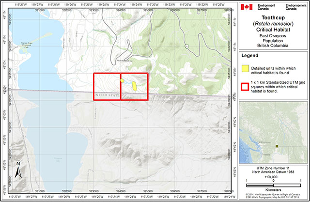
Figure A1. Critical habitat for Toothcup at East Osoyoos, B.C. (corresponds with "Private site, Osoyoos" population" in Provincial Recovery Strategy) is represented by the yellow shaded polygons (units), where the criteria and methodology set out in Section 6.1 are met (i.e., 6.0 ha in total). The 1 km × 1 km UTM grid overlay shown on this figure is a standardized national grid system that indicates the general geographic area containing critical habitat. Areas outside of the shaded yellow polygons do not contain critical habitat. USA landbase is excluded from this critical habitat identification, where it occurs within standardized UTM grid squares.
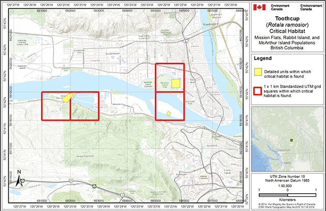
Figure A2. Critical habitat for Toothcup at Kamloops, B.C. (west population Mission Flats, south-central population Rabbit Island, and north-central population McArthur Island; the latter corresponds with "Kamloops Lake, McArthur Island" population in Provincial Recovery Strategy) is represented by the yellow shaded polygons (units), where the criteria and methodology set out in Section 6.1 are met (i.e., 7.0 ha, 1.5 ha, and 9.1 ha, respectively). The 1 km × 1 km UTM grid overlay shown on this figure is a standardized national grid system that indicates the general geographic area containing critical habitat. Areas outside of the shaded yellow polygons do not contain critical habitat.
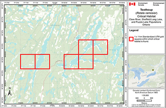
Figure A3. Critical habitat for Toothcup in Ontario: Clare River population (corresponds with "Clare River (Sheffield Long Lake)" population in Provincial Recovery Strategy), Sheffield Long Lake, Ontario ("Sheffield Long Lake" population in Provincial Recovery Strategy), Puzzle Lake East ("Puzzle Lake – E" population in Provincial Recovery Strategy) and Puzzle Lake West ("Puzzle Lake – W" population in Provincial Recovery Strategy) occurs within the 1 km × 1 km standardized UTM grid squares indicated, where the criteria set out in Section 6.1 are met (i.e., 5.4 ha, 1.7 ha, 5.8 ha, and 15.3 ha, respectively). This standardized national grid system indicates the general geographic area containing critical habitat; polygons representing the detailed critical habitat identification are not shown.
Part 2: Recovery Strategy for the toothcup (Rotala ramosior) in British Columbia and Ontario
Prepared by the National Toothcup Recovery Team, for the British Columbia Ministry of Environment and the Ontario Ministry of Natural Resources
Cover illustration: Todd Norris
About the British Columbia recovery strategy series
This series presents the recovery strategies that are prepared as advice to the Province of British Columbia on the general strategic approach required to recover species at risk. The Province prepares recovery strategies to meet its commitments to recover species at risk under the Accord for the Protection of Species at Risk in Canada, and the Canada – British Columbia Agreement on Species at Risk.
What is recovery?
Species at risk recovery is the process by which the decline of an endangered, threatened, or extirpated species is arrested or reversed, and threats are removed or reduced to improve the likelihood of a species' persistence in the wild.
What is a recovery strategy?
A recovery strategy represents the best available scientific knowledge on what is required to achieve recovery of a species or ecosystem. A recovery strategy outlines what is and what is not known about a species or ecosystem; it also identifies threats to the species or ecosystem, and what should be done to mitigate those threats. Recovery strategies set recovery goals and objectives, and recommend approaches to recover the species or ecosystem. Recovery strategies are usually prepared by a recovery team with members from agencies responsible for the management of the species or ecosystem, experts from other agencies, universities, conservation groups, aboriginal groups, and stakeholder groups as appropriate.
What’s next?
In most cases, one or more action plan(s) will be developed to define and guide implementation of the recovery strategy. Action plans include more detailed information about what needs to be done to meet the objectives of the recovery strategy. However, the recovery strategy provides valuable information on threats to the species and their recovery needs that may be used by individuals, communities, land users, and conservationists interested in species at risk recovery.
For more information
To learn more about species at risk recovery in British Columbia, please visit the Ministry of Environment Recovery Planning webpage at: http://www.env.gov.bc.ca/wld/recoveryplans/rcvry1.htm
Recommended citation
National Toothcup Recovery Team. 2008. Recovery strategy for the toothcup (Rotala ramosior) in British Columbia and Ontario. Prepared for the British Columbia Ministry of Environment, Victoria, BC, and the Ontario Ministry of Natural Resources, Peterborough, ON. 22 pp.
Additional copies
Additional copies can be downloaded from the B.C. Ministry of Environment Recovery Planning webpage at: http://www.env.gov.bc.ca/wld/recoveryplans/rcvry1.htm
Publication information
ISBN: 978-0-7726-6056-5
Cataloguing in Publication: Pending
Content (excluding illustrations) may be used without permission, with appropriate credit to the source.
Disclaimer
The British Columbia Ministry of Environment and the Ontario Ministry of Natural Resources led the development of this recovery strategy for toothcup, under the Accord for the Protection of Species at Risk in Canada.
This recovery strategy has been prepared as advice to the responsible jurisdictions and the many different constituencies that may be involved in recovering the species. The recovery strategy does not necessarily represent the views of all individuals on the recovery team or the official positions of the organizations with which the individual recovery team members are associated.
The goals, objectives, and recovery approaches identified in the strategy are based on the best existing knowledge and are subject to modifications resulting from new findings and revised objectives. Implementation of this strategy is subject to appropriations, priorities, and budgetary constraints of the participating jurisdictions and organizations.
Success in the recovery of this species depends on the commitment and cooperation of many different constituencies that will be involved in implementing the directions set out in this strategy.
Recovery team members
National Toothcup Recovery Team
Brdar, Corina; Ontario Ministry of Natural Resources, Ontario Parks, Southeast Zone, Kingston Office
Brownell, Vivian; Botanical Consultant, Metcalfe, ON
Costanzo, Brenda (co-chair); B.C. Ministry of Environment
Crowder, Adele; Queens University, ON
Dyer, Orville; B.C. Ministry of Environment
Fairbarns, Matt; Botanical Consultant, Victoria, BC
Hartley, Karen; Ontario Ministry of Natural Resources, Peterborough
Norris, Todd (co-chair); Ontario Ministry of Natural Resources, Kingston Area
Former Recovery Team Members
Douglas, George (deceased); Botanical Consultant, BC
Krannitz, Pam (retired); Environment Canada, Canadian Wildlife Service
Lea, Ted (retired); B.C. Ministry of Environment
Technical Contacts
Hall, Ron; Osoyoos Indian Band
Authors
René Martin prepared the initial draft; Bryn White prepared the second draft.
Responsible jurisdictions
The British Columbia Ministry of Environment and the Ontario Ministry of Natural Resources are responsible for producing a recovery strategy for toothcup under the Accord for the Protection of Species at Risk in Canada. Environment Canada’s Canadian Wildlife Service participated in the preparation of this recovery strategy.
Acknowledgements
This national recovery strategy is based on an initial draft written by René Martin and a second draft prepared by Bryn White. The Southern Interior Rare Plants Recovery Implementation Team members are thanked for their work on the initial draft and for their review comments on the final draft strategy. Vivian R. Brownell, botanical consultant, prepared a third draft, with assistance from George W. Douglas. The Osoyoos Indian Band provided meeting venues and access to sites in British Columbia. Funding for the initial draft recovery strategy was provided by Environment Canada’s Canadian Wildlife Service and the B.C. Ministry of Water, Land and Air Protection (now the B.C. Ministry of Environment). The Ontario Ministry of Natural Resources funded the finalization of the national recovery strategy. Additional funds for the recovery strategy were provided by the B.C. Habitat Conservation Trust Fund. Carolyn Bonta (contract biologist with the Ontario Ministry of Natural Resources), Todd Norris (Ontario Ministry of Natural Resources) and Brenda Costanzo (B.C. Ministry of Environment) compiled comments from team members to form the final draft.
Executive summary
Toothcup (also known as toothcup meadow-foam in British Columbia) (Rotala ramosior) was designated by the Committee on the Status of Endangered Wildlife in Canada (COSEWIC) as Endangered in April 1999 based on a status report by Douglas and Oldham (1998). This status was confirmed in 2000. Toothcup is listed as Endangered under Schedule 1 of the federal Species at Risk Act. The plant is also listed as Endangered under Ontario’s Endangered Species Act, 2007.
The designation of this species as Endangered by COSEWIC is primarily based on the low number of populations and low abundance of plants at most sites. There are three extant populations and one likely extirpated population in British Columbia, and four extant populations and one extirpated population in Ontario. The current Canadian population is estimated at 18,258 plants of which 67% occur in south-central British Columbia. The largest viable population occurs in British Columbia on private land that, in 2004, contained approximately 98.5% of plants found in the province. Plants on First Nations land made up an additional 1.5% of the British Columbia population. In Ontario, there is an approximately equal split between plants on public (Crown and provincial park land) versus private lands.
Toothcup is currently Red-listed and ranked S1 (critically imperiled) in British Columbia (B.C. Conservation Data Centre 2007) and is ranked S1 in Ontario (Natural Heritage Information Centre; OMNR 2007). The species is listed as Endangered (Not Regulated) on the Species at Risk in Ontario list, and is a candidate for regulation under the provincial Endangered Species Act (1971).
Toothcup is an annual, obligate wetland plant (an emergent hydrophyte) that is subject to wide fluctuations in numbers based on rainfall and water levels. Biologically limiting factors include restricted habitat availability and specific germination requirements, both resulting from toothcup’s affinity for strongly fluctuating water levels.
Threats to toothcup in B.C. include: habitat loss or degradation; changes in ecological dynamics or natural processes (flood regime); invasive species; and cattle browsing, trampling and recreational activities (ATV use) which are potential minor threats. Threats in Ontario include: habitat loss and degradation (conversion to cropland and pastures, development, recreational activities, and shoreline development); changes in ecological dynamics or natural processes (water level fluctuations); and competition with invasive (particularly woody) species.
No critical habitat can be identified for toothcup in Canada at this time, but it may be identified at a later date in a federal addition by Environment Canada, or in a future action plan. It is expected that critical habitat will be proposed following the completion of outstanding work required to quantify specific habitat and area requirements for the species, further research on the biology of the species and monitoring of the populations to determine population trends. Consultation with affected landowners and organizations will also be necessary.
Recovery actions could potentially affect the following socio-economic sectors: land development along foreshore areas, recreational use of provincial parks, agriculture (irrigation), and domestic animal grazing. The expected magnitude of these effects is unknown and will be further addressed in the recovery action plan.
The recovery goal for Toothcup is to protect and maintain the four extant populations in Ontario and the three extant populations in B.C., and to restore the species at historic sites if deemed necessary.
This recovery strategy identifies management actions required to protect and maintain toothcup populations and habitat, and requirements for implementation. The objectives of the recovery strategy are to:
- Ensure the persistence of the species at all known extant sites, with no loss or degradation of currently occupied habitat, for the next five years.
- Assess the extent of the three main threats to the seven populations (habitat loss or degradation, flood regime, and invasive species, flood regime) by 2012.
- Confirm the distribution of Toothcup in Ontario and British Columbia (historic and new locations), and update population and distribution objectives as needed by 2012.
- Investigate the feasibility of restoring populations at extirpated sites or in suitable habitat near historical areas by 2012.
The general approaches that will be taken to address identified threats are:
- habitat protection
- public outreach and stewardship
- inventory and monitoring
- habitat management
- habitat restoration/rehabilitation
- scientific research
In British Columbia, a multi-species action plan will be completed by 2012 for four sand spit species (and others), including toothcup, small-flowered lipocarpha (Lipocarpha micrantha), short-rayed alkali aster (Symphyotrichum frondosum), and scarlet ammannia (Ammannia robusta). An action plan for Ontario sites will also be completed by 2013.
Background
Species assessment information from COSEWIC
Common Name: toothcup
Scientific Name: Rotala ramosior
Status: Endangered
Last Examination and Change: May 2000 (No change)
Canadian Occurrence: British Columbia, Ontario
Reason for designation: An annual plant present at very few remaining sites. It has limited occurrence across habitat and shows population fluctuations. It is subject to continued threats from habitat development and elevated water levels.
Status history: Designated Endangered in April 1999. Status re-examined and confirmed in May 2000. Last assessment based on an existing status report.
Description of the species
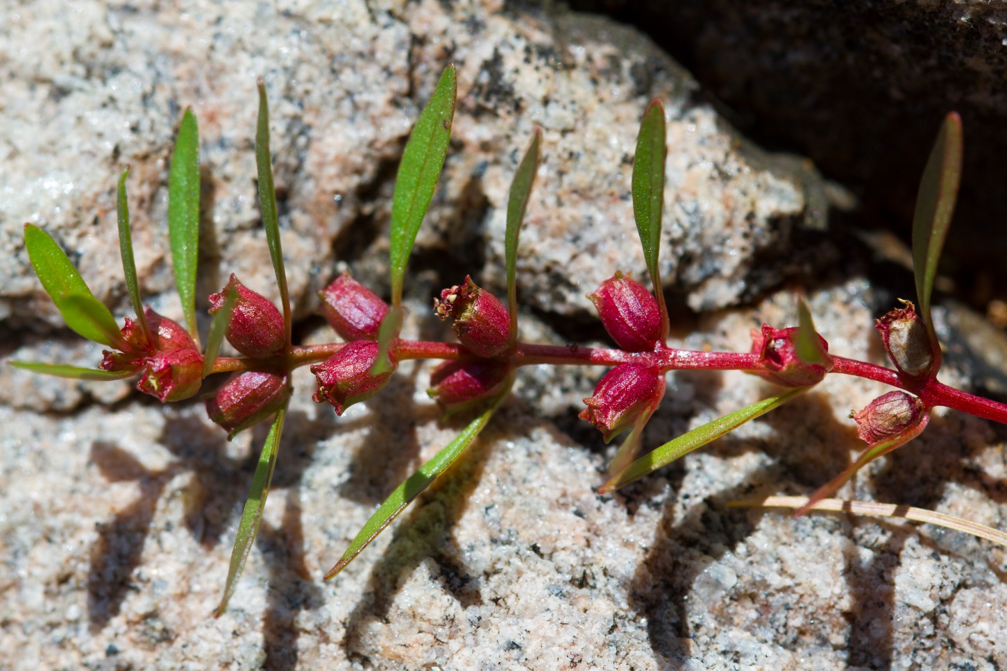
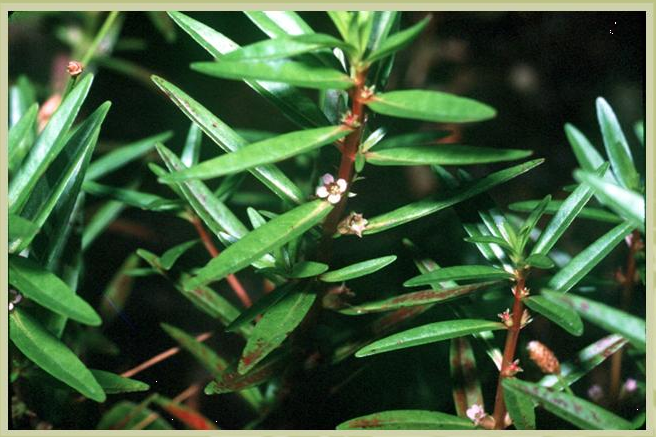
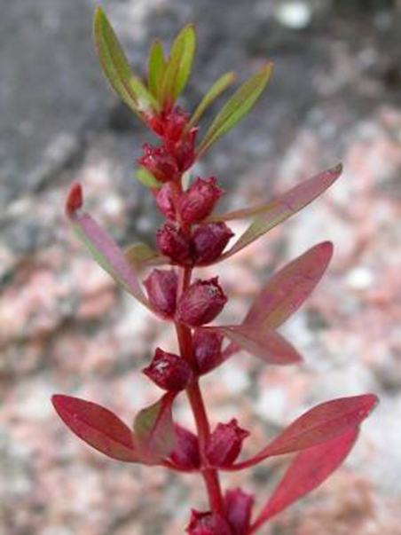
Toothcup (also known as toothcup meadow-foam in British Columbia) is an annual plant that grows up to 40 cm tall. Generally green, most Ontario and British Columbia populations have a reddish tinge in the late summer. Leaves are 1–5 cm long, oblong in shape, and positioned in opposite pairs. Small flowers occur individually along the stem, at the junction of a leaf. Petals are pinkish-white, and the fruits develop into 3 mm long, roundish seed capsules that become green (or cranberry red). Hundreds of seeds are typically produced by an individual plant.
Population distribution and abundance
Population distribution
Each known toothcup population is referred to as a "site," and each site may contain several separate groups, or sub-populations. A distinct site (or population) is one that is separated by 1 km or more from the next nearest site (NatureServe 2008).
Global range
Globally, toothcup ranges from south-central British Columbia and southeastern Ontario, south throughout most of the United States (where it is documented in reports from 42 states, the exception being some Midwestern states; NatureServe 2008; see Table 1 for an overview of toothcup’s conservation status in North America). Figure 1 shows the North American range for toothcup (from Oldham and Sutherland 1987). Toothcup’s range also extends from the southern United States into Mexico and to South America. It has also naturalized in the Philippines and in northern Italy.
Toothcup is considered a disjunct species in the Great Lakes region. The populations in British Columbia and Ontario likely represent post-glacial remnants of this rare vegetation type.
Table 1. Conservation status of Toothcup at the subnational level (from NatureServe 2008)
|
Country |
Province or State |
NatureServe rank code |
NatureServe rank |
|---|---|---|---|
|
Canada |
British Columbia |
S1 |
Critically Imperiled |
|
Canada |
Ontario |
S1 |
Critically Imperiled |
|
US |
Alabama |
SNR |
Unranked |
|
US |
Arizona |
S1 |
Critically Imperiled |
|
US |
California |
SNR |
Unranked |
|
US |
Colorado |
S1 |
Critically Imperiled |
|
US |
Connecticut |
S1S2 |
Critically Imperiled/Imperiled |
|
US |
Delaware |
S3 |
Vulnerable |
|
US |
District of Columbia |
SNR |
Unranked |
|
US |
Florida |
SNR |
Unranked |
|
US |
Georgia |
SNR |
Unranked |
|
US |
Idaho |
SNR |
Unranked |
|
US |
Illinois |
SNR |
Unranked |
|
US |
Iowa |
S3 |
Vulnerable |
|
US |
Kansas |
SNR |
Unranked |
|
US |
Kentucky |
S4 |
Apparently Secure |
|
US |
Louisiana |
SNR |
Unranked |
|
US |
Maryland |
S4S5 |
Apparently Secure/Secure |
|
US |
Massachusetts |
S1 |
Critically Imperiled |
|
US |
Michigan |
S3 |
Vulnerable |
|
US |
Minnesota |
S2 |
Imperiled |
|
US |
Mississippi |
S5 |
Secure |
|
US |
Missouri |
SNR |
Unranked |
|
US |
Montana |
S1 |
Critically Imperiled |
|
US |
Nevada |
SNR |
Unranked |
|
US |
Nebraska |
S3? |
Vulnerable(?) |
|
US |
New Hampshire |
SH |
Possibly Extirpated (Historical) |
|
US |
New Jersey |
S3 |
Vulnerable |
|
US |
New York |
S2 |
Imperiled |
|
US |
North Carolina |
S5 |
Secure |
|
US |
Ohio |
SNR |
Unranked |
|
US |
Oklahoma |
SNR |
Unranked |
|
US |
Oregon |
S2 |
Imperiled |
|
US |
Pennsylvania |
S3 |
Vulnerable |
|
US |
Rhode Island |
S1 |
Critically Imperiled |
|
US |
South Carolina |
SNR |
Unranked |
|
US |
South Dakota |
SNR |
Unranked |
|
US |
Tennessee |
SNR |
Unranked |
|
US |
Texas |
SNR |
Unranked |
|
US |
Virginia |
S5 |
Secure |
|
US |
Washington |
S1 |
Critically Imperiled |
|
US |
West Virginia |
S3 |
Vulnerable |
|
US |
Wisconsin |
SNR |
Unranked |
Canadian range
In British Columbia, toothcup has been reported at four sites, one of which is likely extirpated (Figure 2 and Table 2). The Mica Spit site, on Osoyoos Lake, contains one extant sub-population; habitat of two other sub-populations has been destroyed. A second extant site exists at Osoyoos, on private land. Toothcup was discovered in 1981 at McArthur Island, on Kamloops Lake, and was reconfirmed at this site for the first time in 2004. Toothcup was recorded at the Haynes Point Provincial Park site, on Osoyoos Lake in 1953 but has not been seen since, despite regular surveys from 1991 to the present.
In Ontario, toothcup has been reported at five sites in southern Ontario (Figure 3 and Table 3). This species was first discovered in Ontario in 1984 near St. Williams, but has not been seen at that site since 1987; that population is considered extirpated (Douglas and Oldham 1998). Four populations, three of which were discovered in 1994 by V. Brownell (see Brownell et al. 1996; Brownell 1997) and one discovered in 2004 by the Ontario Ministry of Natural Resources (OMNR), are considered extant (Figure 3). The two Sheffield Long Lake populations are separated by approximately 930 m, and the Puzzle Lake West population is separated from the Puzzle Lake East population by 910 m. These are regarded as separate sites using the 1 km rule because the distances measured above are straight line distances. True distances upon the lake are close to 1 km. The closest Sheffield Long Lake population is 1.87 km from the closest Puzzle Lake population to the east. All extant populations are found within a distance of 5.2 km from each other.
Figure 1. Generalized distribution of toothcup, Rotala ramosior, in North America (adapted from Oldham and Sutherland 1987)
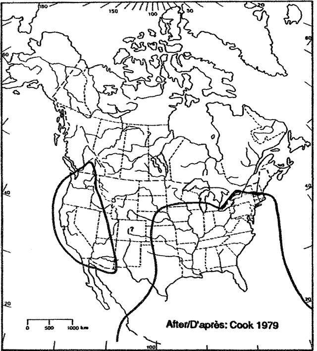
Figure 2. British Columbia distribution of toothcup, Rotala ramosior (Circles are urban centres, stars represent extant populations, and triangles represent extirpated populations)
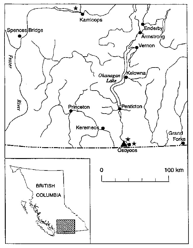
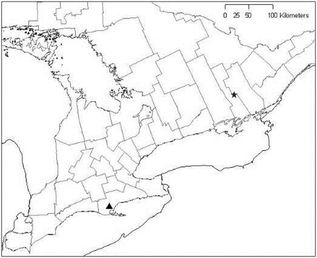
Figure 3. Ontario distribution of toothcup, Rotala ramosior (based on map in Oldham and Sutherland 1987); triangle represents extirpated population in Haldimand-Norfolk Regional Municipality; star represents four extant sites in Lennox and Addington County
Percent of global distribution in Canada
Canada contains less than 1% of the global distribution of this species.
Distribution trend
Of the nine known Canadian sites, habitat has been destroyed at one entire site in Ontario, at one entire site in B.C., and at two of three subpopulations at another site in B.C. Habitat quality at one site on Mica Spit (Osoyoos Lake, BC) has been degraded through invasion of woody vegetation, although this site is being restored through shrub removal. Habitat quality and quantity at the remaining sites is unknown and requires investigation.
Toothcup is considered extirpated from two out of nine sites in Canada: one in B.C., and one in Ontario. The species is confirmed extirpated from one site in southwestern Ontario; plants were not found during surveys in 1989 and 1997 and the primary habitat has since been destroyed through conversion to pasture and cropland (Douglas and Oldham 1998). Toothcup is also considered extirpated from Haynes Point Provincial Park in British Columbia, where the natural substrate was removed and replaced with coarse sand for beach management purposes.
Population abundance
Global abundance
Toothcup is ranked as G5 (globally secure), although the global population size is unknown. In the United States, toothcup is considered nationally secure and is ranked N5 (secure) (NatureServe 2008). Toothcup occurs in 42 states, with sub-national rankings between S5 (secure) and S1 (critically imperiled) (Table 1; NatureServe 2008). Toothcup is legally listed as endangered in Connecticut, Rhode Island and Massachusetts, and threatened in Minnesota and New York (USDA Natural Resource Conservation Service 2003).
Canadian abundance
Based on 2004 data (last survey of the populations), the Canadian population is estimated at 18,258 plants, of which approximately 67% occur in southwestern British Columbia. As this species is an annual, it is expected that there are fluctuations in population numbers year-to-year. The species is ranked as critically imperiled in Canada (N1), British Columbia (S1), and Ontario (S1) (NatureServe 2008). It is assessed as Endangered by COSEWIC. Characteristics of British Columbia’s four populations and their sub-populations (Douglas and Oldham 1998; Douglas 1999; G. Douglas, pers. comm., 2004) are shown in Table 2. Table 3 describes characteristics of Ontario’s five populations and their sub-populations (Brownell 1997; Veit 2000; Bonta 2004).
Table 2. Population sizes at sites surveyed for toothcup, Rotala ramosior, in British Columbia
|
Site/Sub-population |
Survey date(s) |
Extent |
Number |
Ownership |
|---|---|---|---|---|
|
1a. Osoyoos Lake, Mica Spit |
27 July 1994 |
6 m² |
200 |
Osoyoos Indian Reserve |
|
1a. Osoyoos Lake, Mica Spit |
15 August 1995 |
6 m² |
250 |
Osoyoos Indian Reserve |
|
1a. Osoyoos Lake, Mica Spit |
1999 |
Extirpated |
0 |
Osoyoos Indian Reserve |
|
1b. Osoyoos Lake, Mica Spit |
26 July 1994 |
50 m² |
50 |
Osoyoos Indian Reserve |
|
1b. Osoyoos Lake, Mica Spit |
15 August 1995 |
50 m² |
2000 |
Osoyoos Indian Reserve |
|
1b. Osoyoos Lake, Mica Spit |
15 July 1997 |
- |
0 |
Osoyoos Indian Reserve |
|
1b. Osoyoos Lake, Mica Spit |
20 August 1999 |
150–200 m² (50 m × 4 m) |
5000+ |
Osoyoos Indian Reserve |
|
1b. Osoyoos Lake, Mica Spit |
29 August 2001 |
- |
0 |
Osoyoos Indian Reserve |
|
1b. Osoyoos Lake, Mica Spit |
11 August 2002 |
- |
0 |
Osoyoos Indian Reserve |
|
1b. Osoyoos Lake, Mica Spit |
5 August 2003 |
2 m² |
0 |
Osoyoos Indian Reserve |
|
1b. Osoyoos Lake, Mica Spit |
29 August 2004 |
~100m² |
180 |
Osoyoos Indian Reserve |
|
1b. Osoyoos Lake, Mica Spit |
August 2006 |
~ 5000 |
Osoyoos Indian Reserve |
|
|
1c. Osoyoos Lake, Mica Spit |
5 August 2003 |
1 m² |
4 |
Osoyoos Indian Reserve |
|
1c. Osoyoos Lake, Mica Spit |
29 August 2004 |
Extirpated |
0 |
Osoyoos Indian Reserve |
|
2. Private site, Osoyoos |
31 August 2004 |
1000 m² |
12 000 |
Private |
|
3. Kamloops Lake, McArthur Island |
1981 |
100 m² |
1000 |
Public – Municipal Park |
|
3. Kamloops Lake, McArthur Island |
1994 |
- |
0 |
Public – Municipal Park |
|
3. Kamloops Lake, McArthur Island |
18 August 1996 |
- |
0 |
Public – Municipal Park |
|
3. Kamloops Lake, McArthur Island |
28 July 1997 |
- |
0 |
Public – Municipal Park |
|
3. Kamloops Lake, McArthur Island |
13 August 2002 |
- |
0 |
Public – Municipal Park |
|
3. Kamloops Lake, McArthur Island |
5 Sept. 2004 |
1 m² |
3 |
Public – Municipal Park |
|
4. Osoyoos Lake, Haynes Point |
1953 |
Unknown |
Unknown |
Public – Haynes Point Prov. Park |
|
4. Osoyoos Lake, Haynes Point |
1991 |
0 |
0 |
Public – Haynes Point Prov. Park |
|
4. Osoyoos Lake, Haynes Point |
1994 |
0 |
0 |
Public – Haynes Point Prov. Park |
|
4. Osoyoos Lake, Haynes Point |
1995 |
0 |
0 |
Public – Haynes Point Prov. Park |
|
4. Osoyoos Lake, Haynes Point |
1997 |
0 |
0 |
Public – Haynes Point Prov. Park |
|
4. Osoyoos Lake, Haynes Point |
1999 |
0 |
0 |
Public – Haynes Point Prov. Park |
|
4. Osoyoos Lake, Haynes Point |
2002 |
Extirpated |
0 |
Public – Haynes Point Prov. Park |
|
Total in British Columbia |
1994 |
56 m² |
750 |
|
|
Total in British Columbia |
1995 |
56 m² |
2250 |
|
|
Total in British Columbia |
1999 |
200 m² |
5000+ |
|
|
Total in British Columbia |
2002 |
- |
0 |
|
|
Total in British Columbia |
2003 |
1 m² |
4 |
|
|
Total in British Columbia |
2004 |
1003 m² |
12 183 |
|
|
Total in British Columbia |
2006 |
~100 m² |
~ 5000 |
Table 3. Population sizes of toothcup, Rotala ramosior, in Ontario
|
Site/Sub-population |
Survey date(s) |
Extent |
Number |
Ownership |
|---|---|---|---|---|
|
1. St. Williams |
1984 1987 1989 1997 |
Unknown Unknown - Extirpated |
Present Present 0 0 |
Private |
|
2a. Clare River (Sheffield Long Lake) |
1994 2000 2003 2004 |
Unknown 7-m spread - 4 m² |
Unknown Unknown 0 ~1000–3000 |
Public – Crown land |
|
2b. Clare River (Sheffield Long Lake) |
1994 2000 2003 2004 |
Unknown 2 m² - 40-m spread |
Unknown 250–2700 "A couple thousand" (~2000) |
Private |
|
3. Sheffield Long Lake |
8 October 2004 |
5 m² |
215 |
Public – Municipal |
|
4a. Puzzle Lake – W |
2000 2003 2004 |
1.6 m² - Extirpated? |
200 0 0 |
Private |
|
4b. Puzzle Lake – W |
1994 2000 2003 2004 |
Unknown 20 m² - 8-m spread |
Unknown 5 0 400 |
Public – Puzzle Lake Provincial Park |
|
4c. Puzzle Lake – W |
August 25 2004 |
8-m spread |
700 |
Private |
|
4d. Puzzle Lake – W |
August 25 2004 |
6 m² |
40 |
Public – Puzzle Lake Prov. Park |
|
4e. Puzzle Lake – W |
August 25 2004 |
1 m² |
"Several hundred" (~400) |
Private |
|
4f. Puzzle Lake – W |
August 25 2004 |
Unknown |
50–70 |
Public – Crown land |
|
5a. Puzzle Lake – E |
1994 2000 2003 2004 |
Unknown 60 × 10 cm - Unknown |
Unknown 50 0 150–200 |
Public – Puzzle Lake Prov. Park |
|
5b. Puzzle Lake – E |
25 August 2004 |
4 m² |
70–100 |
Public – Puzzle Lake Prov. Park |
|
Total in Ontario (extant populations only) |
1994 2000 2003 2004 |
83 505–525 0 ~6025 |
46.5–66% of plants in Ontario are on private lands, as of 2004 |
Percent of global population in Canada
Probably less than 1% of the global population of toothcup is in Canada.
Population trend
Because this species is an annual plant, and therefore subject to fluctuating numbers, data are insufficient to determine population trends at any of the sites. Toothcup populations in southeastern Ontario were surveyed by the Ontario Ministry of Natural Resources in 2000 (Veit 2000), 2003 (no plants were seen), and 2004 (Bonta 2004). Since toothcup’s discovery in Ontario in 1994, seven additional sub-populations and one new population have been found, and the number of plants has seemingly increased from less than 100 to over 6000, although this may be attributable to variation in climatic variables and/or search efforts. Surveys in British Columbia indicate the number of plants found was 750 in 1994, and 12,183 plants in 2004. Two smaller sub-populations have become extirpated since 1995 (Douglas 1999).
Needs of the Toothcup
Habitat and biological needs
Toothcup has been found on sandy, muddy, or rocky freshwater shorelines, which are not necessarily uncommon in southern Ontario and in British Columbia. However, toothcup has some relatively specific requirements that prevent it from being more common. This species requires open, strongly fluctuating, low nutrient shorelines in both Ontario and British Columbia. Habitats that the plant occupies in British Columbia and Ontario are described below.
Habitat characteristics, including plant associates, are described in detail in Douglas and Oldham (1998) for British Columbia, and in Bonta (2004) and Veit (2000) for Ontario.
British Columbia: Toothcup depends on water-level fluctuations for the creation and maintenance of suitable habitat. In British Columbia, toothcup inhabits moist to wet, often alkaline, muddy shorelines of lagoons or ponds, or sandy shorelines. These sites are submerged early in the year, with plants emerging when lake levels go down in late July to early September. At the lagoon on the east side of Osoyoos Lake, Eleocharis acicularis (needle spike-rush) is a constant companion along with various small herbaceous species, including Gnaphalium spp. (cudweed). Both at the Osoyoos Lake Mica Spit site and at the privately owned site near Osoyoos, many other rare species occur with toothcup. These include Chamaesyce serpyllifolia spp. serpyllifolia (thyme-leaved spurge), Cyperus squarrosus (awned cyperus), Eleocharis rostellata (beaked spike-rush), and Ammannia robusta (scarlet ammannia).
Ontario: Habitat for toothcup in Ontario includes flattish sandy, muddy, and/or sandy gravel depressions situated on pre-Cambrian bedrock shorelines at four extant sites along Sheffield Long Lake (Clare River) and Puzzle Lake. At some of these sites, toothcup is found growing out of cracks in the bedrock but again, only very near shore. Soils are thin (0–5 cm depth) and droughty. Both lakes are in Lennox and Addington County. The biophysical attributes of the surrounding rock barren landscape are described in detail in Brownell (1997). While remains of a dam exist at the southern end of Puzzle Lake, stop logs are no longer present to allow for effective damming of the lake’s water levels (B. Edwards, pers. comm., 2006). Beaver dams are frequently built on the old dam structure and these can raise water levels significantly, with the lake level varying by as much as 1.3 m throughout the year. Occasionally, as reported by Edwards, the beaver dams are removed if water levels become high enough to flood low-lying shorelands for long enough periods to cause trees to die. The habitat is submerged for several weeks in the spring and early summer (Brownell et al. 1996), but water levels recede and most plants are located approximately 1 m above the waterline during seed production in September (Veit 2000; Bonta 2004). Sites are present on both private and public (Crown and provincial park) land. The former habitat of the extirpated site near St. Williams was unique because it was not associated with a lakeshore, but instead consisted of a wet meadow (Douglas and Oldham 1998).
Limiting factors
Water-level fluctuations: Toothcup requires strongly fluctuating water levels to complete its life cycle. As an obligate annual plant, its population numbers undergo wide fluctuations from year to year, dependent on the water-level regime at the site. Germination takes place under flooded conditions, and flowering and seed production occur as the water level recedes and the habitat dries (Cook 1979). The changing nature of the habitat reduces competition from other species by flooding terrestrial vegetation and keeping the habitat free of woody plants that would shade the diminutive toothcup, thereby reducing its vigour.
Threats
The COSEWIC status report by Douglas and Oldham (1998) identifies shoreline development and controlled water-level regimes as the primary threats to extant sites. Large-scale hydrological changes producing either a permanent lowering or raising of water levels, or abnormal fluctuations, would result in a significant decline or extirpation of some populations.
Threat categories are arranged in order of descending priority.
Threats in British Columbia
Habitat loss or degradation: Shoreline development presents the most significant known threat to toothcup in British Columbia. Cottage and housing development affect existing and potential toothcup habitat on private and First Nations land via the creation of docks, boat ramps, boathouses, and sheds along the shoreline. Significant development adjacent to or in the area of the lagoon at Osoyoos Lake (location of the First Nations Mica Spit site) may irreversibly alter lagoon hydrology, and affect toothcup populations. The removal of native substrate and subsequent replacement with coarse sand have contributed to population extirpation at the Haynes Point Provincial Park site (Douglas and Oldham 1998). Threats to the McArthur Island site (Kamloops Lake) are unknown.
Changes in ecological dynamics or natural processes: flood regime: Water levels are artificially controlled at Osoyoos Lake sites in B.C. In the case of the Mica Spit site on Osoyoos Lake, water levels are maintained by water control structures in the United States. The Mica Spit site for toothcup occurs on and around a lagoon, whose water level is directly related to lake levels. If lake water levels were maintained higher, then the seed bank of toothcup (at the Mica Spit site and other sites on the lake) would not be exposed and would not be able to germinate. Conversely, if lake water levels were maintained at a lower level, the plant would not flower, or seeds would not be able to germinate (T. McIntosh, pers. comm., 2006).
Invasive species: Invasive non-native plants (e.g., Russian olive, willows) pose a potential threat to toothcup by reducing available habitat and competing for resources. Efforts to control invasive plants through mechanical or chemical means may inadvertently harm extant and currently unknown populations or individuals of toothcup.
Other potential threats: Cattle browsing, trampling and recreational activities such as all-terrain vehicle use could threaten toothcup populations.
Threats in Ontario
Habitat loss and degradation: Conversion of the habitat to cropland and pasture caused extirpation of the species at the St. Williams, Ontario site (Brownell et al. 1996). Increased development on Puzzle and Sheffield Long lakes may dramatically increase threats to toothcup. Potential campsites have been identified on Puzzle Lake within the park. However, all development in the park will be carried out in ways that will ensure the protection of any species at risk (OMNR 2001). Cottage development is also a potential threat to toothcup in Ontario. Both campsite and cottage development encourage recreational activities, such as swimming and boating, that could dramatically affect toothcup populations through trampling or dislodging plants. Shoreline development, such as cottages, boat ramps, and public beaches, is another serious threat.
Changes in ecological dynamics or natural processes: One of the greatest threats to habitat occurs from extended flooding or drying due to altered water levels. This can result from water level stabilization and/or abnormal fluctuations.
Other potential threats: Inter-specific competition with invasive species is also a less significant threat.
Actions already completed or underway
At Osoyoos Lake, efforts have been made to reduce threats at the Mica Spit site through fencing and removal of invasive plant species. Removal of invasive species by the Osoyoos Indian Band was funded by the Habitat Stewardship Program from 2004 to 2007. As well, there have been discussions with the International Joint Commission (IJC) for Osoyoos Water Levels and the recovery team regarding potential research projects to determine the water-level requirements of the species during all life phases.
OMNR has sent letters to private landowners in Ontario informing them of the occurrence of this species on their property and inviting them to participate in recovery efforts. Some of the landowners expressed interest in the protection of the species. Provincial park management reflects consideration of this species within its jurisdiction.
In both provinces, local botanists continue to monitor known sites and surveys for new populations.
Knowledge gaps
Inventory and monitoring requirements
Annual monitoring over a relatively long period of time is required, for all extant populations, to accurately assess population trends. Inventory and assessment of potential habitats are required in south-central British Columbia and southern Ontario to identify new populations. Because seed banks can persist in an area without obvious evidence of plants, surveys should be conducted over multiple years. Potential restoration sites need to be identified and restoration projects must be monitored annually.
Biological/ecological research requirements
There is a need to know whether soil characteristics play major roles in determining success of toothcup growth and maintenance. For example, is soil texture critical? Since toothcup has been described in some parts of its range as growing in mud, sand, burnt marsh soil, rice fields, and so on, soil texture may not be that limiting. Additionally, there is a need to discern the effects of soil pH, calcium content, potassium, nitrogen, and phosphorus. Water chemistry may also play a role, and research on total conductivity, clarity, colour, pH, calcium, and other nutrients could prove useful. Understanding these attributes will lead to a better assessment of potential habitat.
Research into light characteristics (wavelengths and duration) and ambient temperature for germination, as well as germination rates, are needed. The potential for establishing new populations through the introduction of seeds or seedlings into suitable habitats should be assessed. Conditions for seed germination, seed dispersal, and seed bank viability must be determined to facilitate restoration and re-introductions. Additional scientific research on seed production in toothcup is required to determine whether seed supply or habitat limit the Canadian populations.
The effects of hydrology and water regime on germination and growth must be quantified to assist with identifying suitable habitat for re-introduction. More detailed understanding of within- and between-year water-level fluctuations at all sites and the apparent effects on toothcup growth and numbers must be sought. This will require the establishment of standard measuring protocols.
Further research into the seasonal growth changes of toothcup at all Canadian sites is required. For example, in any given year when do new plants first appear? How quickly do they grow? How many remain submerged and for how long? When do flowers first appear and does this vary much across the range? When do seeds first develop and when do capsules begin to open?
What pollinators are at work on toothcup plants? Other factors such as competition and predation will also affect population sustainability and establishment, which can contribute to our development of population targets to guide recovery. There is also a need to discern genetic differences and similarities between the British Columbia and Ontario population. As well, a comparison of abiotic and biotic habitat attributes between sites alongside with demographic studies of stable populations vs. potentially declining populations.
Threat clarification research requirements
Potential threats related to land development, habitat disturbances, water-level fluctuations, non-native invasive plants, and all-terrain vehicle activity must be investigated.
Recovery
Recovery feasibility
Recovery of Toothcup is considered by the recovery team to be biologically and technically feasible (Table 3).
If the habitat and suitable conditions can be maintained, toothcup is expected to remain at known sites. The level of effort required to recover this population is moderate and includes habitat preservation, stewardship and public education, restoration, and management (including involvement of IJC if appropriate), as well as population introduction, monitoring, and inventory. Significant challenges to recovery include development pressure, recreational use, and private landowner cooperation. Also, additional populations may be discovered if thorough surveys are conducted of potential habitat and historical sites.
Table 4. Biological and technical recovery feasibility. Criteria from Environment Canada et al. (2005)
|
Criteria |
Toothcup |
|---|---|
|
Yes - there are seven extant populations in Canada, each with reproductively capable individuals. |
|
Yes - the habitat at the currently occupied sites is suitable, and habitat at some of the previously occupied sites could be restored. Additional suitable habitat may also be available. |
|
Yes - recovery actions such as stewardship and cooperation with landowners and land managers can prevent major threats. |
|
Yes - standard propagation techniques exist for raising new stock for translocation; also, general restoration methods/techniques are known. |
Recovery goal
The recovery goal for toothcup is to protect and maintain the four extant populations in Ontario and the three extant populations in B.C., and to restore the species at historic sites if deemed necessary.
Population and distribution objectives
Specific targets for population numbers are not possible at this time due to the species being an annual (therefore population sizes are highly variable) and also the lack of survey data for determining long-term population trends.
Recovery objectives
The main objectives of the recovery strategy for toothcup are to:
- Ensure the persistence of the species at all known extant sites, with no loss or degradation of currently occupied habitat, for the next five years.
- Assess the extent of the three main threats to the seven populations (habitat loss or degradation, flood regime, and invasive species, flood regime) by 2012.
- Confirm the distribution of Toothcup in Ontario and British Columbia (historic and new locations), and update population and distribution objectives as needed by 2012.
- Investigate the feasibility of restoring populations at extirpated sites or in suitable habitat near historical areas by 2012.
Specific steps to be taken to meet the recovery objectives are listed in Table 4.
Approaches recommended to meet recovery objectives
The general approaches that will be taken to address identified threats are:
- habitat protection
- public outreach and stewardship
- inventory and monitoring
- habitat management
- habitat restoration/rehabilitation
- scientific research
Associated specific steps and expected outcomes are summarized in Table 5.
Recovery planning table
Table 5. Recovery planning table
|
Priority |
Obj. no. |
Broad approach / strategy |
Threat addressed |
Specific steps |
Outcomes or deliverables |
|---|---|---|---|---|---|
|
Urgent |
1 |
Habitat protection |
Habitat loss or degradation |
|
|
|
Necessary |
1 |
Habitat protection |
Changes in ecological dynamics or natural processes |
|
|
|
Urgent |
1 |
Public outreach – stewardship with private landowners and First Nations; habitat management |
Habitat loss or degradation; Recreational use of shorelines (other threats) |
|
|
|
Necessary |
1, 3 |
Inventory and monitoring – survey current, historical and potential habitat |
All |
|
|
|
Necessary |
1, 2 |
Habitat management |
Exotic species (inter-specific competition) |
|
|
|
Beneficial |
4 |
Habitat and population restoration |
Habitat loss and degradation |
|
|
|
Beneficial |
1 |
Habitat protection – legal protection |
Habitat loss and degradation |
|
|
|
Beneficial |
2, 4 |
Scientific research |
All |
|
|
Performance measures
Criteria for evaluation of the progress towards the goals and objectives of this strategy include:
- Population monitoring indicates that the numbers of plants at the sites are stable or increasing, by 2012 (Objective 1);
- Impact of the three main threats to the populations has been investigated as well as a reduction of threats by 2012 (Objective 2);
- Agreements with appropriate resource managers are developed to mitigate the impacts of fluctuating water levels and support toothcup and other rare plant populations from this threat by 2012 (Objective 2).
- Surveys of suitable habitat for new populations has been conducted and documented by 2012 (Objective 3);
- Historic sites are investigated as potential habitat for re-introduction and restoration, where appropriate, in B.C. and in Ontario by 2012 (Objective 4).
Critical habitat
Identification of the species' critical habitat
No critical habitat can be identified for toothcup in Canada at this time, but it may be identified at a later date in a federal addition by Environment Canada, or in a future action plan. It is expected that critical habitat will be proposed following the completion of outstanding work required to quantify specific habitat and area requirements for the species, further research on the biology of the species and monitoring of the populations to determine population trends. Consultation with affected landowners and organizations will also be necessary.
Because so little is known about toothcup’s persistence in the seed bank, it is possible that seeds are still present in the substrate. Historic sites may be considered for inclusion as critical habitat if they are needed for re-introduction purposes.
Recommended schedule of studies to identify critical habitat
The following three studies will be done in both British Columbia and Ontario, and will allow for the identification of critical habitat for extant populations:
- Identify habitat attributes at extant sites (e.g., moisture regime, length of inundation and exposure, soil and water chemical properties, plant cover, water clarity) by 2012.
- Using established survey and mapping techniques (applied during phenologically appropriate periods), delineate the boundaries of all occupied habitats by 2012.
- For each occupied habitat, delineate the boundaries and condition of the associated shoreline with respect to fluctuations in water levels (temporal and spatial) and any large-scale hydrological changes by 2012.
The following three studies will be done in British Columbia only, and will facilitate the identification of additional critical habitat:
- Identify, map, and describe all suitable sites in the north and south Okanagan valley that are currently unoccupied by species at risk. Rate these habitats for their potential to support scarlet ammannia, as well as other species at risk by 2012.
- Identify, map, and rate any significant shorelines in the north and south Okanagan valley for restoration potential where the habitat attributes indicate that suitable habitat may exist but the structure and/or function has been lost or compromised as a result of alien plant invasion, urbanization, or water-level changes by 2012.
- Through experimental trials, test the suitability of high-ranking sites for plant translocations/reintroductions by 2012.
A comprehensive survey of suitable habitat in southwestern Ontario may reveal additional populations of toothcup. The extent of occurrence of populations and associated vegetation communities may be mapped in years where the populations are evident, to contribute to critical habitat identification.
Existing and recommended approaches to habitat protection
Toothcup is listed as Endangered on the Species at Risk Ontario List regulation under the Endangered Species Act, 2007 which provides the plant with species protection. The habitat of this species receives protection through the provisions of the Provincial Policy Statement (PPS) of the Ontario Planning Act, which requires that planning agencies must "be consistent with" the PPS in land use planning (Ontario Ministry of Municipal Affairs 2005). The PPS states that "development and site alteration are not permitted in significant habitat of endangered and threatened species."
In British Columbia, protection of the species will be achieved in cooperation with First Nations, private landholders, and the City of Kamloops. Stewardship will be the main emphasis, but other mechanisms may also be involved in maintenance of the species.
Stewardship approach
For successful implementation of species at risk protection, there will be a strong need to engage in stewardship on various land tenures, and in particular on private land. Stewardship involves the voluntary cooperation of landowners to protect species at risk and the ecosystems they rely on.
The Preamble to the federal Species at Risk Act (SARA) states that "stewardship activities contributing to the conservation of wildlife species and their habitat should be supported" and that "all Canadians have a role to play in the conservation of wildlife in this country, including the prevention of wildlife species from becoming extirpated or extinct." The Canada – British Columbia Agreement on Species at Risk also recognizes that "stewardship by land and water owners and users is fundamental to preventing species from becoming at risk and in protecting and recovering species that are at risk" and that "cooperative, voluntary measures are the first approach to securing the protection and recovery of species at risk."
In addition, Ontario’s Biodiversity Strategy identifies stewardship as a key strategic direction for conserving biodiversity in Ontario (OMNR 2005).
Stewardship approach for private lands
Since many species at risk occur only or predominantly on private lands, stewardship efforts will be the key to their conservation and recovery. To successfully protect many species at risk, there will have to be voluntary initiatives by landowners to help maintain areas of natural ecosystems that support these species of risk. Examples of this stewardship approach include following guidelines or best management practices to support species at risk; voluntarily protecting important areas of habitat on private property; establishing conservation covenants on property titles; eco-gifting part or all of their property to protect certain ecosystems or species at risk; or selling their property for conservation. For example, both government and non-governmental organizations have had good success in partnering with private landowners to conserve private lands in B.C. and Ontario. This could be aided by stewardship programs and local land trusts.
Effects on other species
In both Ontario and British Columbia, it is believed that any actions taken for toothcup will benefit other species and ecosystems.
In British Columbia, toothcup is found with small-flowered lipocarpha (Lipocarpha micrantha; S1) and scarlet ammannia (Ammannia robusta; S1), which are two COSEWIC-designated endangered species, and sometimes short-rayed alkali aster (Symphyotrichum frondosum). Three of these species have similar, but not identical, habitat requirements and face similar threats. In addition, awned cyperus (Cyperus squarrosus; S2) always occurs with small-flowered lipocarpha and is Red-listed by the British Columbia Conservation Data Centre. A total of 18 Red-listed plant species now occur with toothcup at the Mica Spit site on Osoyoos Lake, including red-rooted cyperus (Cyperus erythrorhizos; S1), hairy water-clover (Marsilea vestita; S1), bushy cinquefoil (Potentilla paradoxa; S1), and capitate spike-rush (Eleocharis geniculata; S1 in Ontario). This last species has only recently been identified at this location in British Columbia and will be assessed by COSEWIC sometime in 2009. Because the entire Okanagan-Similkameen area contains many endangered and threatened species, several of which are found in riparian/wetland areas, recovery efforts should focus on an ecosystem- or landscape-level plan.
At three Ontario sub-populations on Puzzle Lake, toothcup is found growing with two extant S1 species: Engelmann’s spike-rush (Eleocharis engelmannii) and false pimpernel (Lindernia dubia var. anagallidea). These two associates are known from several locations in Ontario and western Canada and are considered rare in Canada (both are ranked N1 in Canada) by Argus and Pryer (1990). These species have not yet been considered for assessment by COSEWIC, but would likely be evaluated as threatened. Several other provincially rare species are found associated with toothcup sub-populations that also depend on fluctuating lakeshores or lakeshore microclimate. These include shinners three-awn grass (Aristida dichotoma; S1); bear oak (Quercus ilicifolia; S1); and panic grass (Panicum rigidulum; S2S3). Both shinners three-awn grass and bear oak are restricted in their occurrence in Canada to the Puzzle Lake area and to Sheffield Long Lake. These species have not yet been considered for assessment by COSEWIC, but would likely be evaluated as endangered. Recovery efforts in Ontario could therefore benefit several species if a multi-species approach was taken.
Socio-economic considerations
Recovery actions could potentially affect the following socio-economic sectors: land development along foreshore areas; recreational users of provincial parks; agriculture (irrigation); and domestic animal grazing. The expected magnitude of these effects is unknown and will be further addressed in the recovery action plan.
Recommended approach for recovery implementation
A multi-species recovery approach is recommended for toothcup, small-flowered lipocarpha, scarlet ammannia, and other provincially listed species in British Columbia. These species all share similar threats and have similar property ownership in the southern Okanagan valley; any activities for recovery will be done in conjunction with the Southern Okanagan-Similkameen Conservation Program.
Although all three of these species occur in Ontario, toothcup does not share sites or property ownership with the others. A species-specific approach is the most appropriate for the recovery of the species in that province.
Statement on action plans
In British Columbia, a multi-species action plan will be completed by 2012 for four sand spit species (and others), including toothcup, small-flowered lipocarpha, short-rayed alkali aster, and scarlet ammannia.
An action plan for Ontario sites will also be completed by 2013.
References
Argus, G.W. and K.M. Pryer. 1990. Rare vascular plants in Canada: our natural heritage. Can. Museum of Nature, Botany Division, Canada: Rare and Endangered Plants Project, Ottawa, ON.
Baskin, C.C., J.M. Baskin, and E.W. Chester. 2002. Effects of flooding and temperature on dormancy break in seeds of the summer annual mudflat species Ammannia coccinea and Rotala ramosior (Lythraceae). Wetlands 22(4):661–668.
British Columbia Conservation Data Centre. 2007. BC Species and Ecosystems Explorer. British Columbia Ministry of Environment. Victoria, BC. Available: http://srmapps.gov.bc.ca/apps/eswp/. [Accessed November 8, 2007].
Brownell, V.R. 1997. A biological inventory and evaluation of the Puzzle Lake Area of natural and scientific interest. Prepared for the Ont. Min. Nat. Resour., Peterborough District. 121 pp. + 2 maps.
Brownell, V.R., C.S. Blaney, and P.M. Catling. 1996. Recent discoveries of rare southern vascular plants at their northern limits in the granite barrens area of Lennox and Addington County, Ontario. Can. Field-Nat. 110(2):255–259.
Cook, C.D.K. 1979. A revision of the genus Rotala (Lythraceae). Boissiera 29:1–156.
Douglas, G.W. 1999. Status of toothcup in British Columbia. B.C. Min. Environ., Lands and Parks, Wildlife Branch and Resources Inventory Branch, Victoria, BC. 6 pp.
Douglas, G.W., D. Meidinger, and J.L. Penny. 2002. Rare native vascular plants of British Columbia. 2nd edition. Province of British Columbia, Victoria, BC. 359 pp.
Douglas, G.W. and M.J. Oldham. 1998. Status report on toothcup (Rotala ramosior [L.] Koehne in von Martius). Committee on the Status of Endangered Wildlife in Canada, Ottawa, ON. 20 pp.
Environment Canada. 2004. Federal policy discussion paper: critical habitat. Species at Risk Recovery Program (February 2004). http://www.sararegistry.gc.ca/virtual_sara/files/policies/Critical%20Habitat%20Discussion%20Paper_e.pdf Accessed [March 2004]
Environment Canada, Parks Canada Agency, and Fisheries and Oceans Canada. 2005. Species at Risk Act policy: recovery – draft policy on the feasibility of recovery. April 15, 2005. Ottawa, ON.
NatureServe. 2008. NatureServe. 2008. NatureServe Explorer: An online encyclopedia of life [web application]. Version 7.0. NatureServe, Arlington, Virginia. Available http://www.natureserve.org/explorer. (Accessed: June 23, 2008).
Oldham, M.J. and D.A. Sutherland. 1987. Rotala ramosior (L.) Koehne . One page in K.M. Pryer and G.W. Argus, eds. Atlas of the rare vascular plants of Ontario. Part 4. National Museum of Natural Sciences, Ottawa, ON (looseleaf).
Ontario Ministry of Municipal Affairs and Housing. 2005. Provincial policy statement. Queen’s Printer, Toronto, ON. http://www.mah.gov.on.ca/Asset1421.aspx Accessed [March 2005]
Ontario Ministry of Natural Resources. 2001. Puzzle Lake Provincial Park (natural environment class) – P4: 2001 Recreation Resource Assessment. Kingston, ON. 17 pp. + appendices.
Natural Heritage Information Centre. 2007. http://nhic.mnr.gov.on.ca/MNR/nhic/species.cfm [Accessed November 8, 2007].
U.S. Department of Agriculture (USDA) Natural Resource Conservation Service. 2003. http://plants.usda/gov/
Veit, L. 2000. Report on toothcup (Rotala ramosior) field visit – Aug. 24, 27, and Sept. 7, 2000. Ont. Min. Nat. Resour., Kingston Area Office. 4 pp. + 1:10,000 map.
Personal communications
Douglas, George. 2004. Botanical Consultant.
Edwards, Barry. 2006. Landowner, Precambrian Inn.
McIntosh, Terry. November 2006. Private consultant. Biospherics Environmental Inc.
Footnotes
- footnote[*] Back to paragraph Rank 1– critically imperiled; 2– imperiled; 3- vulnerable to extirpation or extinction; 4- apparently secure; 5– secure; H– possibly extirpated; NR – status not ranked
- footnote[i] Back to paragraph Committee on the Status of Endangered Wildlife in Canada
- footnote[ii] Back to paragraph The Species at Risk in Ontario (SARO) List is a regulation under the Endangered Species Act, 2007 similar in context to Schedule 1 of the Species at Risk Act.
- footnote[**] Back to paragraph United States (S) Ranks: Alabama (SNR), Arizona (S1), Arkansas (SNR), California (SNR), Colorado (S1), Connecticut (S1S2), Delaware (S4), District of Columbia (SNR), Florida (SNR), Georgia (SNR), Idaho (SNR), Illinois (SNR), Indiana (SNR), Iowa (S3), Kansas (SNR), Kentucky (S4), Louisiana (SNR), Maryland (S4S5), Massachusetts (S1), Michigan (S3), Minnesota (S2), Mississippi (S5), Missouri (SNR), Montana (S1S2), Nebraska (S2S4), New Hampshire (SH), New Jersey (S3), New York (S2), North Carolina (S5), Ohio (SNR), Oklahoma (SNR), Oregon (S2), Pennsylvania (S3), Rhode Island (S1), South Carolina (SNR), South Dakota (SNR), Tennessee (SNR), Texas (SNR), Virginia (S5), Washington (S1), West Virginia (S3), Wisconsin (SNR
- footnote[***] Back to paragraph The three goals of the B.C. Conservation Framework are: 1. Contribute to global efforts for species and ecosystem conservation; 2. Prevent species and ecosystems from becoming at risk; 3. Maintain the diversity of native species and ecosystems
- footnote[iii] Back to paragraph An "extant" site is one which is considered to be still in existence, i.e., not destroyed or lost (extirpated).
- footnote[iv] Back to paragraph "Populations" are characterized as being separated by 1 km, and "sub-populations" represent records of individuals, or patches of individuals, that are within 1 km of each other.
- footnote[v] Back to paragraph An "extirpated" population is one which was previously known to occur (i.e., for which there is historical record), but that no longer exists.
- footnote[vi] Back to paragraph Osoyoos Lake, "Mica Spit" population in the provincial recovery strategy, and the "North Osoyoos Oxbows" population as described in section 4 of this federal addition.
- footnote[vii] Back to paragraph Critical function zone distance has been defined as the threshold habitat fragment size required for maintaining constituent microhabitat properties for a species (e.g., critical light, moisture, humidity levels necessary for survival). Existing research provides a logical basis for including a minimum critical function zone distance of 50 m as part of critical habitat for rare plant species occurrences. Accounting for up to maximum 100 m GPS error, the default critical function zone distance (in the absence of distinct ecological features, see below), is a maximum 150 m.
- footnote[viii] Back to paragraph "Distinct" ecological, or landscape features are features that are able to be distinguished through the use of detailed ecosystem mapping or aerial photos, which appear as ecologically contiguous features with distinct boundaries at that scale (e.g. cliffs, banks, or slopes, drainage basins, seepage plateaus, shoreline inlets/lagoons, or distinct vegetation assemblages), and which comprise the context for a species occurrence. Distinct ecological features may be contained within, or extend beyond, the critical function zone distance; in the latter circumstance the critical habitat identification will be increased where appropriate.
- footnote[ix] Back to paragraph The draw-down zone is the area at the edge of a body of water that is frequently and/or seasonally exposed to the air owing to water-level changes caused by evaporation, water usage, and/or management of control dams.
- footnote[x] Back to paragraph Area calculated using Albers projection (BC), and UTM 18 projection (ON).
- footnote[xi] Back to paragraph Research on germination and survival requirements, and corresponding habitat attributes such as hydrology and water regime, has been identified as a knowledge gap in the provincial recovery strategy. More detailed understanding of the effects of within- and between- year water-level fluctuation on Toothcup growth and abundance at all life history stages is required).
- footnote[xii] Back to paragraph http://www.ceaa.gc.ca/default.asp?lang=En&n=B3186435-1