Marten Falls community based land use plan terms of reference
Terms of reference for Marten Falls First Nation community based land use planning.
December 2013
Marten Falls First Nation and the Ministry of Natural Resources are pleased to sign the Terms of Reference for the Marten Falls First Nation Community Based Land Use Plan. Approvals have been provided by:
- Marten Falls First Nation Band Council Resolution; and
- Ontario, by the Minister of Natural Resources administering the Far North Act.
As we begin this planning process, Marten Falls First Nation and the Ministry of Natural Resources affirm our commitment to work together with mutual respect and in good faith.
On behalf of Marten Falls First Nation
Chief Elijah Moonias
Marten Falls First Nation
On behalf of Ontario
Honourable David Orazietti
Minister of Natural Resources.
1. Introduction
Marten Falls First Nation (MFFN) is developing a community based land use plan (CBLUP) for the use of community members including staff, leaders, and representatives to address environmental and cultural issues, and to identify and plan socio-economic development strategies with the growing economic and resource development activities on Marten Falls’ historical traditional lands and waterways. A planning process will be employed by MFFN, working together with Ontario, as represented by the Ministry of Natural Resources (MNR), to achieve the end result of a community based land use plan. (As per the Far North Act).
Background of Marten Falls First Nation
Marten Falls First Nation (MFFN) is located 100 air miles (160 kilometres) north of Nakina, Ontario on the junction of the Ogoki and Albany Rivers. The original Marten Falls community relocated to the Albany and Ogoki River junction in 1926. MFFN was originally located at the actual Marten Falls, 50 miles up the Albany River from this current site. The treaty 1905 was signed at the original Marten Falls site.
Approximately 250 members currently reside in Marten Falls and over 2/3 of community members reside off reserve (total population of over 600). MFFN is a proud and progressively oriented First Nation community that has adapted well to the changing lifestyle and economies that the 20th century has to offer, at the same time retaining the important customs and cultural teachings that are linked to the lands and river ways that form their way of life.
MFFN is interested in preparing a plan to:
- ensure the protection of areas valued by the community;
- ensure the documentation of information on the community’s historical use and relationship to the land;
- identify land use activities that support (sustain) the cultural, environmental and socio-economic objectives of the MFFN membership;
- help strengthen the community’s self-reliance through the identification of economic development opportunities;
- identify shared areas to assist in relationship protocols with neighbouring First Nations; and
- identify key anishnabek people (members and other stakeholders) in their traditional area i.e. trappers, tourist outfitters, medicine harvesters, commercial fishers, guides and others that use the land that need to be engaged regarding the CBLUP.
Background to First Nation-Ontario joint planning approach
In the context of Ontario’s Far North Land Use Planning Initiative, the Ministry of Natural Resources works jointly with First Nations in the Far North to develop community based land use plans. The Far North Act came into force in 2010; its purpose is to provide for community based land use planning in the Far North that:
- sets out a joint planning process between the First Nations and Ontario;
- supports the environmental, social and economic objectives for land use planning for the peoples of Ontario; and
- is done in a manner that is consistent with the recognition and affirmation of existing Aboriginal and treaty rights in section 35 of the Constitution Act, 1982, including the duty to consult.
Thus, in response to MFFN’s expressed interest in planning, MNR is engaging in this joint planning project with MFFN in accordance with the Far North Act.
2. Purpose of the Terms of Reference
The purpose of this Terms of Reference (TofR) is to guide the designation of a planning area and guide the preparation of a community based land use plan for that area. The joint MFFN-MNR planning team has prepared the TofR to describe a shared understanding between MFFN and MNR on the context and scope of planning, expected outcomes and steps in the process. The TofR includes descriptions of the requirements to complete the mandatory components of a plan as specified under the Far North Act.
3. Authority
MFFN and MNR are working together to prepare the land use plan. The joint planning team makes decisions by consensus. MFFN determines readiness to move forward at each step in the planning process. Where joint approvals are required, the authority for making approvals is provided by MFFN Chief and Council and the Minister of Natural Resources. Specific approval requirements are outlined in Section 8, Approval Mechanisms.
4. Principles, goals, objectives and expected outcomes of the planning process
Principles
MFFN has provided the following principles to guide the planning process:
-
“Kezhikanawabajikateg kaye ji tepwaaniwaang kekikinozhiwemakaang.”
“Everything on our land and water is living and needs to be respected.”
The land and all of its living creatures are viewed by the anishnabek as integral to the circle of life and integral to the survival and balance and harmony of the environment that anishnabek is only one part of. -
“Kawininitojikateg nikan onajikewining ineke.”
“The anishnabek relationship to the land should be seen as a cultured landscape; also an area that is continuously being used by the anishnabek as a habitation and as a resource”
The anishnabek are of the land; their customs, identity, and cultures are tied intricately to the land and its resources. -
“Kakina ji wiinda mawa nowaht anishnabek ka onjiwatch.”
“Engage the anishnabek on all issues that affect our shared and communal lands.”
All anishnabek should be treated with respect and therefore, are to be engaged on matters that affect their lives directly. -
“ jih ishi kanawejikatey kakina kekon”
“Respect the natural and Anishnawbe customs and teachings at all times.”
The Creator put Anishnabek on these lands as stewards of the land to take care of the lands and use the lands and its resources indefinitely. The only conditions were to adhere to the natural and traditional teachings of the elders. -
“Chi Mamow waban ji kateg emishiinonaniwang mashkawisiinaniwang”
“Looking at it together. In numbers there is strength.”
With consultation, the more persons that are directly affected, the more need to be involved in the process; therefore, the process will need to find ways to accommodate anishnabek people (members and other stakeholders).
Goals
MFFN has expressed the following goals for planning.
It is our hope that the planning process will:
- represent a shared understanding among MFFN, government and stakeholders;
- guide the protection and orderly development of the land and its resources;
- harmonize proposed new land uses with existing and customary land use practices of MFFN;
- ensure MFFN customary stewardship responsibilities for the land remain intact; and
- promote land use planning to membership who may not know of the intent and/or status of the planning process.
Objectives
In the Far North Act, Ontario sets out the following objectives for land use planning:
- a significant role for First Nations in the planning;
- the protection of areas of cultural value in the Far North and the protection of ecological systems in the Far North by including at least 225,000 square kilometres of the Far North in an interconnected network of protected areas designated in community based land use plans;
- the maintenance of biological diversity, ecological processes and ecological functions, including the storage and sequestration of carbon in the Far North; and
- enabling sustainable economic development that benefits the First Nations.
These objectives have been taken into account in the preparation of the TofR, and will be taken into account in the preparation of the land use plan.
Expected outcomes
The planning process is set out to provide for achievement of the following outcomes:
- documentation of Aboriginal Traditional Knowledge to support planning, as guided by MFFN;
- assembly of all other available information to support planning;
- definition of a planning area by the Draft Plan stage, to be documented in the Draft Plan and, recommended for designation under the Far North Act;
- provisions for:
- MFFN community members to be fully engaged in the planning dialogue;
- dialogue with adjacent communities to support understanding of shared areas and interests within the planning area; and,
- at least two formal opportunities for input from the community, adjacent communities and all interested people and organizations;
- preparation of a Draft Plan and Final Plan, to include identification of:
- land use areas and their designation (e.g. dedicated protected areas, general use areas, and enhanced management areas) including one or more protected areas;
- land uses and activities that are permitted or not permitted within each area;
- how the plan has addressed the significant cultural and ecological features, land uses and land use designations for areas adjacent to the planning area; and
- a plan review timeframe as well as direction for plan amendment;
- opportunity for each of MFFN and Ontario to build consensus on documents and planning recommendations at each stage of planning; and
- recommendation for joint approval of the Final CBLUP by MFFN and MNR.
As planning proceeds, planning will incorporate Ontario’s broader policy direction and emerging guidance (e.g. Far North Land Use Strategy). When prepared, the Far North Land Use Strategy will support community based land use planning. For example, the Strategy can provide policy and information on big-picture, broad-scale land use interests, matters that are often beyond the geographic scope of individual plans.
5. Scope of planning
The scope of the land use plan is described in this section in terms of geography and planning subjects.
Geography
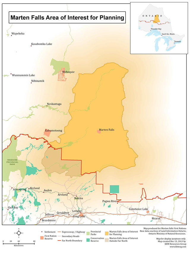
Marten Falls First Nation has identified an Area of Interest for Planning (AIP). The MFFN AIP is 4,265,385 hectares in size, situated approximately 276 km northeast of Thunder Bay, Ontario (see Figure 1). First Nation communities located adjacent to this AIP are: Eabametoong, Aroland, Webequie, Neskantaga, Attawapiskat, Constance Lake, Fort Albany and Kashechewan.
In traditional understandings among First Nation communities, shared land use and widespread travel by community members is customary. MFFN respects adjacent communities’ shared uses and interests within the AIP. The AIP is mapped in order for MFFN to lead preparation of a CBLUP for that area. While MFFN’s traditional use also extends beyond the AIP (as depicted by the gradually shaded area in Figure 1) engagement will be required with neighbouring communities as they prepare their plans.
Through dialogue between MFFN and the adjacent communities, understandings and protocols for engagement in the planning process (and implementation of the plan) can be set out. In planning, MFFN will be striving to provide direction that considers the interests of and benefits for MFFN and all First Nations.
The AIP set out in Figure 1 is subject to adjustment resulting from dialogue with adjacent communities, leading to definition of the final MFFN Planning Area. The final MFFN Planning Area will be confirmed in the Draft Plan stage, documented in the Draft Plan and recommended for designation as a planning area under the Far North Act. Approval of the Final Plan is contingent upon having a designated planning area.
In Figure 1, MFFN has identified a geographic area in the Far North of Ontario (3,784,849 ha) and has also identified an area of traditional use and interest that extends south of the Far North (480,536 ha). The final MFFN Planning Area defined for the purpose of preparing a CBLUP under the Far North Act will include only Far North geography.
In preparing the CBLUP, the joint planning team will address the area extending south of the Far North as an adjacent area for consideration of the significant cultural and ecological features, existing land uses and land use designations. Existing land use direction for the area south of the Far North is documented (and kept up-to-date) online in the Crown Land Use Policy Atlas (CLUPA). In these areas engagement in planning takes place through existing processes (e.g. land use and resource management planning, environmental assessments).
At the time of preparing these Terms of Reference (2013) adjacent community dialogue has been initiated with all communities noted above.
Planning subjects
The land use plan will provide direction considering existing and potential land uses and resource-based opportunities in the planning area. Planning subjects are identified in this section, along with a brief description of expected scope and outcome(s). For each planning subject, the scope of dialogue will be guided by plan goals and objectives that will reflect cultural, social, economic and environmental considerations.
Planning Subjects include (but are not limited to) the following:
- Historical and contemporary Indigenous use
- Provide direction to harmonize historical livelihood pursuits with strategic direction and new uses.
- Describe the relationship of MFFN with respect to the planning area, and identify objectives to address the First Nation’s interests.
- Protection/conservation/protected areas
- Provide principles, objectives and strategic direction expressing community and provincial protection/conservation interests.
- Will include a description of the land base in terms of existing protected areas.
- May include a review of existing protected area (i.e. parks) with the possibility of recommendations for changes to existing boundaries and/or the type of protected area.
- Recommend one or more protected areas within the planning area with:
- respect for historical and ongoing traditional use;
- emphasis on protection of areas of cultural importance and valued ecological systems; and
- consideration of contribution(s) to:
- First Nation livelihood and stewardship interests;
- an interconnected network of protected areas ;
- protection of species at risk and their habitat;
- conservation of the integrity of water resources and systems;
- natural heritage representation in Ontario;
- review existing protected areas (parks) in the context of landuse planning with the recommendation for changes (e.g. boundary, type, what can be done); and
- achievement of Ontario’s Far North objectives.
- Forestry, including non-timber forest products (NTFP)
- Describe the land base in terms of its capability for forestry activities.
- Identify the type of sustainable forestry opportunity that would be of interest to pursue (e.g. cutting trees for local-scale use, NTFP harvesting, etc.).
- Recommend land use zoning to support desired opportunities.
- Geoscience and the mineral sector (exploration and mining)
- Provide information relevant to mineral exploration and development (e.g. maps of bedrock geology, surficial geology, known mineral deposits, claim holders, abandoned mine hazards, and areas of significant mineral potential).
- Identify existing mining claims.
- Provide explanations of mineral exploration and development (the mining sequence) and the implications of Mining Act modernization for future activities.
- Describe options for possible future mineral sector activities.
- Provide information relevant to public health and safety; the current state of the environment; infrastructure needs; and economic opportunities (e.g. environmental base-line data, and maps of surficial geology / aggregate resources).
- Recommend land use zoning to support desired opportunities.
- Renewable energy
- Describe the land base in terms of its potential for renewable energy development.
- Recommend land use zoning to support desired opportunities.
- Recreation
- Identify capabilities and recommendations for recreation opportunities.
- Recommend land use zoning to support desired opportunities.
- Tourism
- Identify existing and potential tourism opportunities.
- Recommend preferred tourism activities and direction to enhance tourism.
- Promote dialogue with existing tourism operators and cabin owners within the community’s trap line areas to build mutual respect and understanding.
- Recommend land use zoning to support desired opportunities.
- Infrastructure (transportation, transmission, etc.)
- Identify interests and needs for infrastructure developments such as roads or corridors for both the community and the broader region in which it is located.
- Describe the availability of aggregate resources and features in the planning area that might be important to support future infrastructure development.
- Provide guiding direction to support future design and assessment of infrastructure location/corridors in land use zones.
- Recommend land use zoning to support identified interests/needs.
- Water and waterways use
- Describe water resources and the importance of sustaining the integrity of water resources of all kinds (e.g. ground water, lakes, rivers, wetlands).
- Describe waterways and their historical, cultural and ecological significance.
- Identify waterway opportunities for recreation, tourism, and other uses.
- Provide strategic direction for the protection and conservation of waterways as they are significant landscape characteristics with cultural importance.
- Recommend land use zoning to support desired uses while providing for protection of the integrity of waterways.
Additionally, the planning team will consider a number of topics as they are relevant to land use planning and decision making, including:
- Climate change mitigation and adaptation
- The planning team will invite experts/advisors to help build an understanding of climate change, the possible impacts of climate change in Far North landscapes and ways in which the plan direction might contribute to the mitigation of climate change.
- Consideration of cumulative effects
- The planning team will seek advice on the manner in which the land use plan might address the consideration of cumulative effects for land use activities, for example, expression of principles, strategic direction, implementation actions, etc.
- Fish and wildlife management
- The planning team will build an understanding of the relationship between the land use plan objectives/recommendations/direction and Ontario fish and wildlife management direction, policy or legislation. Plan direction will be consistent with existing provisions; however the plan may also identify future considerations.
- Fire management
- The planning team will invite provincial advisors to help build understanding of the provincial fire management strategy and the relationship between the land use plan outcomes and the fire management strategy. The plan may identify values and priorities for consideration in the implementation of the fire management strategy.
- CBLUP can identify areas that are important.
6. Planning process
The planning process includes a preparation stage and four formal phases. Table 1 portrays the overall process, and each phase is described in more detail in this section.
Table 1. Summary of the planning process
| Preparation | Phase I | Phase II | Phase III | Phase IV |
|---|---|---|---|---|
|
|
|
|
|
| Fall to Spring 2012/13 | Fall 2013 | Winter 2014 | Fall 2014 | Spring 2015 |
- Preparation – Fall to spring 2012/2013
- Begin community dialogue on planning approach and assembly of Aboriginal Traditional Knowledge.
- Organize for planning, identify the members of the joint planning team (MFFN and MNR), and draft Terms of Reference.
- Map the MFFN Area of Interest for Planning (AIP) and invite dialogue with adjacent communities.
- Hold community meeting(s) to determine readiness to move ahead with planning.
- Seek formal joint endorsement in principle for Terms of Reference (MFFN and MNR).
- Phase I – Fall 2013
- Complete Terms of Reference approvals.
- Invite engagement and formal consultation through notices, Environmental Bill of Rights (EBR) Environmental Registry posting, mail outs, etc.
- Post approved Terms on the Far North website.
- Continue to assemble Aboriginal Traditional Knowledge (ATK) and background information from all sources.
- Continue dialogue with adjacent communities on the AIP to understand shared areas and interests.
- Phase II – Winter 2014
- Describe objectives to guide preparation of the Draft Plan, e.g. for existing and new uses.
- Analyze land and resource information to describe existing use and capabilities for new uses.
- Begin zoning and identification of land use activities to meet objectives.
- Seek and consider feedback from the community and Ontario (MNR, MNDM) on zoning proposals.
- Continue dialogue with adjacent communities on the AIP to understand shared areas and interests.
- Confirm the final MFFN planning area
- Phase III – Fall 2014
- Recommend the MFFN planning area for designation as a planning area under the Far North Act
- Prepare Draft Plan including documentation of the MFFN planning area, recommended zoning, activities and strategic stewardship direction.
- Determine community and Ontario consensus to move forward to consultation on the Draft Plan.
- Provide Draft Plan formal consultation opportunities through community meetings, second Open House, updates to EBR Environmental Registry posting, posting on the Far North website, newspaper notices and mail-outs.
- Phase IV – Spring 2015
- Prepare summary of Draft Plan input, including summary of comments provided on EBR Environmental Registry posting.
- Prepare Final Plan, with consideration of all input to the Draft Plan.
- Provide for sharing and building consensus to move forward, by the community and Ontario.
- Recommend for endorsement through approval processes (First Nations and MNR).
- When approved, provide decision posting on the EBR Environmental Registry (including description of how comments were considered).
- Post Final Plan on Far North website.
7. Planning structure
The relationship of people and organizations in the planning process is illustrated in Figure 2. In this section there is a description of the joint planning team and communications responsibilities and approaches that will support engagement and participation.
The overall planning initiative is led by the direction of Chief and Council. Chief and Council representatives sit on planning and advisory teams to provide guidance and support and to ensure full community engagement in the process.
Planning teams
The planning team is comprised of both MFFN and MNR representatives. Planning team members are required to attend all meetings. Alternate planning team members may be identified; however, parties will be informed of changes in representation in advance of meetings being held.
The advisory team will support the planning team by providing community and provincial input and review as required. Planning team members will draw upon advisory team members to help the planning team building an understanding of planning subjects, assemble and analyze information. Regular exchange of information between the planning team and advisors will also support building a consensus on plan recommendations.
A further description of roles and responsibilities is provided on the next page under Communications.
Figure 2. Planning structure
- Chief and Council - Marten Falls First Nation
- Planning Team
- MFFN CBLUP Coordinator (Harry Baxter)
- MFFN CBLUP Planner (Elizabeth Achneepineskum)
- MFFN Members (Bob Baxter, Corrina Baxter, Irene Baxter, Lucy Achneepineskum)
- MNR Northwest Region Far North Planner (Jill Entwistle)
- Ontario Far North Planner (Paul MacInnis, Ben Bartlett)
- MFFN Community Members
- Technical Advisors
- Consultant (KBM Resources Group)
- MNR District/Region Staff
- Advisory Team
- Community Technical Advisors
- MNR Nipigon District Manager
- MNR Nipigon Area Supervisor
- MNR Far North Manager
- MNDM Regional Manager
- MNDM Regional Land Use Geologist
- MNR Ontario Parks Regional Manager
- MNR Regional Natural Heritage Specialist
- Other advisors as appropriate to planning subjects
Communications
MFFN would like to encourage participation in the community based land use planning process and input to the plan, including ensuring there is a clear contact mechanism for providing feedback during the planning process. MFFN would also like to provide land use planning information and analysis, and progress updates in a variety of formats to community members and key planning partners.
Key communication opportunities
- Quarterly (or more frequent as required) newsletters and website updates to share planning team progress.
- Fact sheet production (as required).
- MFFN Facebook page – update as new information becomes available.
- Updates and news on bulletin board at band office.
- Community meetings periodically at key stages of the planning process to:
- introduce the Process, including Terms of Reference and Communication Strategy, and present completed mapping to date;
- present Terms of Reference prior to final approval;
- gather input on goals, objectives and principles for land use planning, present final land capability maps and mapped results of ATK work, and identify proposed land use designations and permitted uses; and
- present Draft Community Based Land Use Plan.
- Communicate to broader public upon completion of the Terms of Reference, Draft Plan and Final Plan
Table 2: Planning roles and responsibilities
| Key Players | Main Role | Communication Responsibilities/ Linkages |
|---|---|---|
| Marten Falls Community | Provides input to plan components. | Shares perspectives, ideas, knowledge and advice with planning team. |
| Marten Falls Community | Provides input to plan components. | Keeps informed of progress with planning. |
| Chief and Council | Decision Making | Provides guiding direction for plan components. |
| Chief and Council | Decision Making | Approves plan components via Band Council Resolution. |
| MNR | Decision Making | Provides guiding direction for plan components. |
| MNR | Decision Making | Approves plan components as per the Far North Act, 2010. |
| Community Based Land Use Planning Coordinator | Coordination/ Liaison | Receives input from Community Advisory Groups and community members and conveys information to planning team, MNR and consultant. |
| Community Based Land Use Planning Coordinator | Coordination/ Liaison | Receives guidance from Chief and Council and conveys information to planning team, MNR and consultant. |
| Planning Team | Develops Terms of Reference and prepares Plan according to Terms of Reference | Receives guidance and seeks approvals from Chief and Council and communicates results to MNR and consultant. |
| Planning Team | Develops Terms of Reference and prepares Plan according to Terms of Reference | Prepares Terms of Reference. |
| Planning Team | Develops Terms of Reference and prepares Plan according to Terms of Reference | Assembles information from all sources to support planning. |
| Planning Team | Develops Terms of Reference and prepares Plan according to Terms of Reference | Schedules opportunities for input and prepares required materials. |
| Planning Team | Develops Terms of Reference and prepares Plan according to Terms of Reference | Invites and gathers input from Advisory Groups, community members and general public. |
| Planning Team | Develops Terms of Reference and prepares Plan according to Terms of Reference | Provides progress updates to community with respect to plan development, opportunities for input, how input has been incorporated into the plan, etc... |
| Consultant (KBM Resources Group) | Coordinates Plan Development | Calls and Chairs planning team meetings. |
| Consultant (KBM Resources Group) | Coordinates Plan Development | Circulates meeting minutes. |
| Consultant (KBM Resources Group) | Coordinates Plan Development | Ensures input from others is incorporated into plan components. |
| Consultant (KBM Resources Group) | Coordinates Plan Development | Identifies communication opportunities and coordinates communication. |
| Advisory Team (MFFN Community Advisors, MNR, MNDM) | Provides input to plan components. |
Supports the planning team by providing information, analysis and advice on all planning subjects as needed. MNDM’s provides information related to geoscience, mineral exploration and mining; advises on the application of this data to identify areas that may have social, environmental and/or economic implications in the planning area; and assess proposals for land use designations. |
| Community Advisory Groups (elders, youth) | Provides input to plan components. | Gathers perspectives, ideas, knowledge, values from community members to share with planning team. |
| Stakeholders and General Public | Provides input to plan components | Shares perspectives, ideas, knowledge with planning team. |
8. Approval mechanism
The plan is prepared through a consensus-based approach to decision making, reflecting:
- MFFN’s custom process; and
- Ontario’s internal consensus-building within MNR and other agencies (e.g. MNDM)
The Far North Act identifies the requirements and authority for formal joint MFFN-Ontario approvals, including for:
- Terms of Reference; and
- Final Land Use Plan.
Joint approvals for each of the above are required by:
- Marten Falls First Nation Chief and Council; and
- Minister of Natural Resources
Approval of the final plan will be by Minister’s Order under the Far North Act 2010 and by First Nation Band Council Resolution.
Prior to approval of the plan, the planning team will request that the planning area be designated under the Far North Act 2010 via Minister’s Order.
Marten Falls First Nation and MNR will implement these Terms of Reference for a land use plan in good faith. During the planning process new information and/or emerging direction may require an amendment to the Terms of Reference. In this event the planning team would prepare a recommended amendment. Requirements for amendments and approvals are set out in the Far North Act.
9. Dispute resolution process
Ongoing dialogue and feedback throughout the planning process provides a means to resolve issues and disputes prior to approval of the final plan. Issues and/or disputes may arise during plan production both within the First Nation communities and interested parties.
Issues not resolved through discussions with the planning team pertaining to the Planning Area can be addressed directly to the MNR Nipigon District Manager and MFFN Chief and Council. Parties bringing forward a dispute or issue shall provide it in writing to the MNR Nipigon District Manager, and MFFN Chief and Council, along with any proposed resolution. The District Manager will confer with the Chief, as appropriate in an effort to reach agreement on a resolution. The respective parties may also seek advice from the provincial and community advisory groups in reviewing the issue. The District Manager and Chief (or designate) will confer, as appropriate, in an effort to reach a resolution, and will communicate any resolution to the Planning Team within 30 days.
10. Interim measures
The Far North Act provides for orderly development in the Far North. Under the Far North Act, community based land use plans must be completed before most major development begins, including commercial timber harvest or opening a new mine. The Act does allow certain types of development to proceed in advance of a plan, provided certain criteria are met. A development may also be allowed to proceed if it is determined to be predominantly for community use or if it contributes directly to meeting community needs of the First Nations and takes into account the objectives of the Act.
While the planning initiative is underway, MNR and MFFN would expect that the planning team would be invited to comment on development proposals, and that decisions would be consistent with the provisions of the Far North Act.
11. Information management
The planning process will require consideration of all available information to help support and inform joint planning discussions while respecting and protecting Indigenous Knowledge. A joint protocol between the community and MNR will be established that will outline what information will be brought forward by each party and how it will be used in the community based land use planning process.
All information provided by community members to support community input to the planning process (i.e. Aboriginal Traditional Knowledge) will remain with the community unless the community deems it shareable with the Province of Ontario.
Ontario will provide and support the planning team with their best available information and data, to be used for the purpose of community based land use planning.
In addition, the planning team will identify appropriate information management strategies for the information used to support the development of the CBLUP.
Ontario will work with the planning team to ensure compliance with requirements for information under the authority of the Far North Act, Freedom of Information and Protection of Privacy Act and the Archives and Recordkeeping Act. Notices required for public consultation purposes under the Far North Act and the Environmental Bill of Rights will be the responsibility of the MNR. The subjects and results of all consultation will be considered by the planning team and incorporated into the planning process.
The planning team will oversee communications and delegate as required, including developing and ensuring public notices are submitted as required, compiling the appropriate mailing list, initiating mail out of planning phase information, providing notice of meetings, and sharing any other information deemed appropriate.
All formal input and comments received during the planning process will be documented and available as an official planning record. Copies of all formal input and comments received during the process will be provided to the joint planning team.
Contacts
Land Use Planning Coordinator
Marten Falls First Nation
Ogoki Post, Ontario P0T 2L0
Community Based Land Use Planner
Marten Falls First Nation
Ogoki Post, Ontario P0T 2L0
Ministry of Natural Resources
435 South James Street
Ontario Government Building
Thunder Bay Ontario P7E 6S8
Phone: (807) 475-1776 [Invalid number]
Fax: (807) 473-3023 [Invalid Fax]