Mattawa River Provincial Park Management Plan
This document provides policy direction for the protection, development and management of Mattawa River Provincial Park and its resources.
Management Plan
Ministry of Natural Resources
© 1988 Government of Ontario
Single copies of this publication can be obtained from the Ministry of Natural Resources, North Bay District Office, P.O. Box 3070, Highway 63, North Bay, Ontario P1B 8K7, telephone
Price: $2.00 (Tax Included)
ISBN 0-7729-2089-3
Approval statement
We are pleased to release this approved management plan for Mattawa River Provincial Park as policy for its management and development. The plan reflects this Ministry’s intent to protect the natural cultural, and recreational values of Mattawa River Provincial Park and to maintain high quality opportunities for outdoor recreation and heritage appreciation for residents of Ontario and visitors to the province.
Signed by:
M. A. Klugman
Regional Director
Northeastern Region
Signed by:
Norm R. Richards
Director
Parks and Recreational Areas Branch
Queen’s Park
1. Introduction
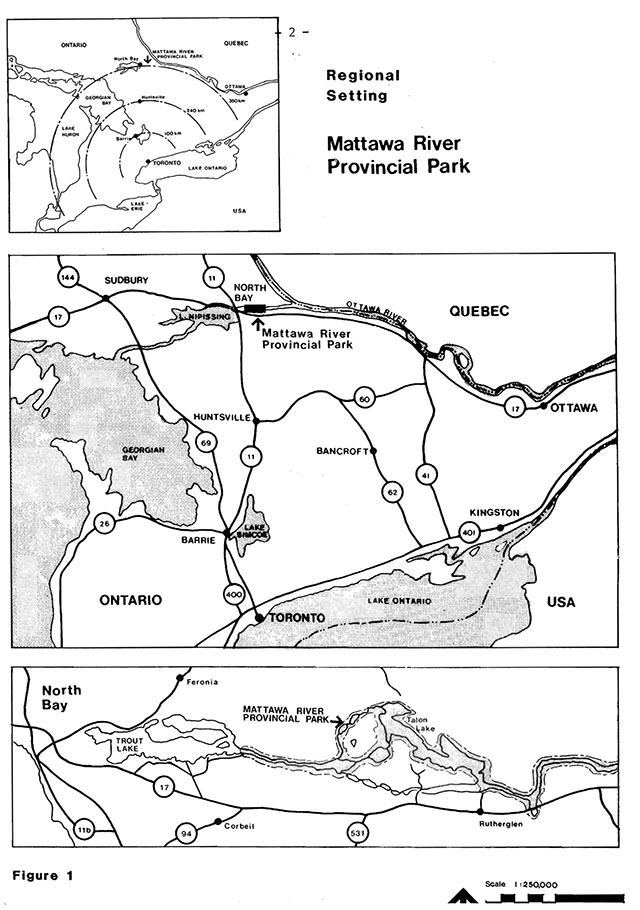
A stairway of placid lakes and steep rapids, the Mattawa River follows an ancient fault line east from Trout Lake to the Ottawa River (Figure 1). For centuries this cliff-sided, pine-mantled valley was part of the historic "Canoe Route to the West". Today, the river is largely undeveloped with its use devoted to water-oriented recreation such as boating, canoeing, fishing, cottaging, and resort and residential development. It was the protection of the many historical, cultural, natural, and recreational values that determined the need to designate Mattawa River as a "waterway" provincial park. It was established in 1970 as the first "wild river" (now waterway) class park in Ontario’s provincial park system.
1.1 Resource characteristics
Mattawa River Provincial Park comprises approximately 3,260 hectares of land and water along roughly 37 kilometres of canoe and motorboat route between Trout Lake in the west and Samuel de Champlain Provincial Park in the east. It consists of the waters of the Mattawa River, including the lakes formed by the widening of the river and a strip of land 122 metres in width measured perpendicularly to the shoreline. All patented lands that lie within this description are excluded from the park. No future land acquisitions are anticipated for park purposes.
The outstanding landform feature of the park is the Mattawa River Fault, a 600 million year old break in the earth’s crust. Lands north of the river are dominated by large rolling hills; south of the river lie gentler graben lowlands. A continental temperate climate characterizes the area. The forest cover is generally a mixture of northern and southern plants, typical of the Great Lakes-St. Lawrence Forest Region to which it belongs. Area wildlife is quite rich in species, reflecting the diversity of vegetation arid the significance of the Mattawa Valley as a distribution corridor for plants and animals.
- Note: All sentences found in quotations and italics are quoted from the Ontario Provincial Parks Planning and Management Policies "Blue Book"
The waterway is located between the City of North Bay and the Town of Mattawa. South of the river and roughly parallel with it is the Trans Canada Highway 17 (Figure 1).
Major attractions and recreation associated with the park include: a nationally significant historic canoe route, variety in canoeing and boating potential, backcountry camping potential, and a natural setting with many scenic features. Other recreation associated with the park include: fishing, swimming, hunting, picnicking, etcetera.
2. Classification
Mattawa River Provincial Park is classified as a Waterway Provincial Park in recognition of the natural and historical values, as well as its ability to provide a variety of water based recreational and educational experiences. Waterway parks, one of six classes of Ontario provincial parks, incorporate outstanding recreational water routes with representative natural features and historical resources. They provide high quality recreational and educational experiences.
The Mattawa River has been nominated by the Ontario Ministry of Natural Resources as a Canadian Heritage River. Nomination was reviewed in 1988 by the Canadian Heritage Rivers Board and the river was accepted for designation as a Canadian Heritage River.
Canadian Heritage Rivers are outstanding examples of Canada’s natural heritage, play a significant role in Canadian history, and offer outstanding opportunities for recreation. This national system of protected rivers has emerged over the last two decades as part of a growing concern to ensure that Canadian rivers are managed wisely.
The purpose of the Canadian Heritage River System is to give national recognition to "important" Canadian rivers. Future management will protect their natural and cultural heritage values, and realize the opportunities they possess for recreation and heritage appreciation. The park management plan is logged with the Canadian Heritage Rivers Board in satisfaction of the requirements for Canadian heritage river designation.
Figure 1: Regional Setting
Enlarge figure 1: Regional Setting
3. Goal
The goal of the park is:
"to maintain and manage outstanding recreational water routes and landscapes having both representative natural features and historical resources to provide high quality recreational and educational experiences."
4. Objectives
The objectives of the park are:
"to contribute to the achievement of Ontario’s provincial park objectives: protection. recreation, heritage appreciation, and tourism."
Park management will respect the rights of landowners adjacent to the park.
4.1. Protection
The protection objective of the park is:
"to protect provincial significant elements of the natural and cultural landscape of Ontario."
The ancient Mattawa River follows a fault structure and has served for thousands of years as a link in the main drainage outlet of the early Great Lakes.
Glacial Lake Algonquin and post Algonquin phases of the early Upper Great Lakes flooded the region for about a thousand years beginning about 11,500 years ago. About 11,000 years ago the Mattawa Valley was freed of glacial ice, resulting in a major drainage outlet for several early systems of the Great Lakes. Evidence of a large prehistoric river shows that it flowed west to east, as the Mattawa River does today.
The river also functioned as an ancient corridor for the distribution of plants and animals and for several hundred years as part of the chief travel corridor between the St. Lawrence settlements and the western interior of Canada.
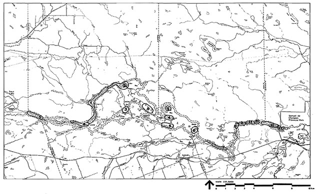
These and several other areas of particular natural or cultural interest have been identified for protection measures. The special features which will be protected through appropriate park management policies include historic portages, an abandoned ochre "mine" which was likely associated with Indian groups, geological features of preglacial and glacial origin, rare plant species and a locally significant waterfowl migration stop (Figure 2).
4.2 Recreation
The following recreation objectives of the park are:
- "to provide day use opportunities in areas of outstanding recreational potential associated within a waterway";
- "to provide facility-based camping opportunities on a waterway and in associated areas of outstanding recreational potential"; and,
- "to provide waterway backcountry travel and camping 'opportunities'".
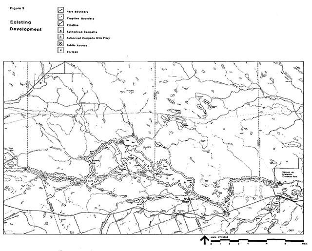
The Mattawa River offers 2,400 waterway backcountry travel and camping opportunities and an extensive range of opportunities for day visitors, which include motorboating, canoeing, swimming, picnicking, hunting, fishing, and heritage appreciation (Figure 3).
No further backcountry travel opportunities will be provided in Mattawa River Provincial Park. However, Samuel de Champlain Provincial Park, which is also on the Mattawa River system abutting the eastern boundary of Mattawa River Provincial Park, will provide additional backcountry travel opportunities. This will help satisfy the need for additional targets as recommended by the North Bay District Land Use Guidelines.
4.3 Heritage appreciation
The heritage appreciation objectives of the park are:
- "to provide opportunities for unstructured individual exploration and appreciation of the waterway heritage of the park"; and,
- "to provide opportunities for exploration and appreciation of natural and cultural environments through interpretation and education based upon the character and significance of the park".
Information concerning significant earth and life science features, historical resources,· and other park values will be provided through the visitor services program in the form of leaflets, signs, plaques, and exhibits. This service will be described in further detail in the section on Visitor Services. The cultural heritage of the Mattawa River is the major interpretive theme of the park, although the life and earth science stories are also important. In addition to the provincial park status, the Mattawa River Provincial Park’s nationally significant cultural values are recognized in its designation to the national system of Canadian Heritage Rivers.
Self-guided and organized interpretation will be provided through the visitor services program at Samuel de Champlain Provincial Park. The 12 meter replica of a Montreal freight canoe and trade goods presently displayed at Samuel de Champlain Provincial Park foster appreciation of the fur trade heritage. The visitor services program uses guided hikes, audio-visual presentations, brochures, and other means to encourage appreciation of the heritage resources of the Mattawa River.
4.4 Tourism
The tourism objective of the park is:
"to provide Ontario’s residents and out-of-province visitors with opportunities to discover and experience distinctive regions of the province".
The park will continue to support complementary local tourism services by providing opportunities to discover and experience the distinctive environment of the Mattawa River Valley and area.
5. Zoning
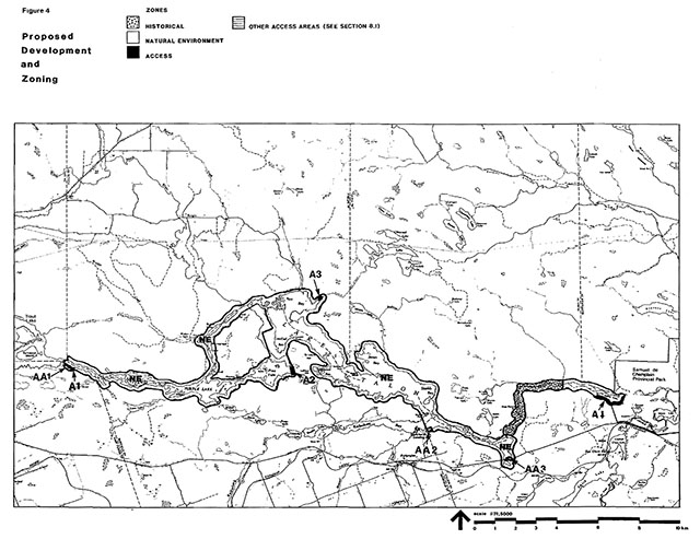
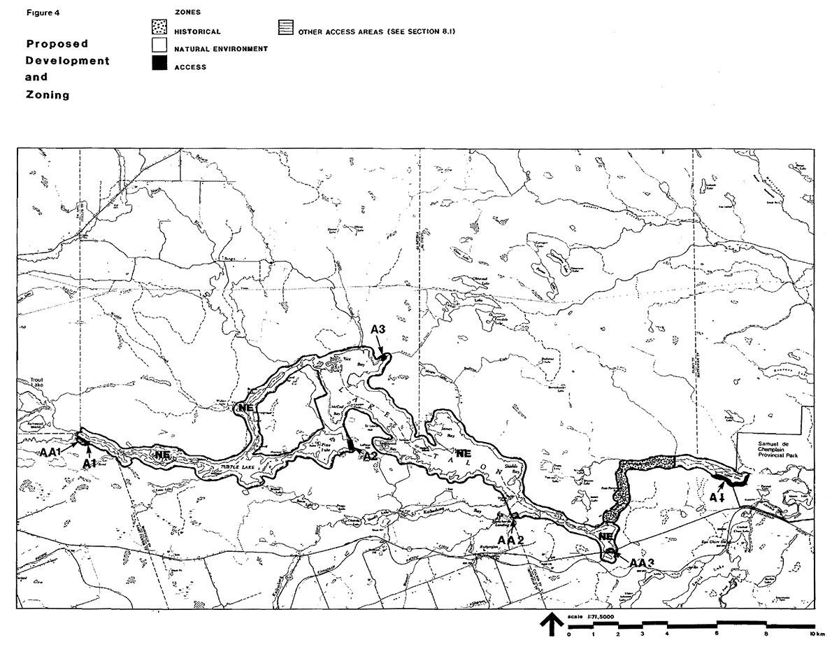
Three types of zones have been designated to guide the management of. Mattawa River Provincial Park: access, natural environment, and historical (Figure 4).
5.1 Access zones (36 hectares)
The purpose of the access zones are:
"to serve as staging areas where a minimum of facilities support the use of less developed portions of the water route."
Access zones are designated to establish adequate and strategic entry points to the Mattawa River system to facilitate a system of travel loops. They will provide orientation to the park visitors and will facilitate surveys of traffic and use patterns within the park.
Development will be limited to a minimum of roads, parking lots, control structures, self-use orientation/interpretive facilities, educational/research facilities, and management facilities. Facilities for basic commercial services for visitors including outfitting services for backcountry travellers may also be permitted.
All significant areas that occur within access zones will be protected.
Additional access to Mattawa River Provincial Park is also available through three areas, which lie outside the park (see Development Section).
MacPherson Drive access zone A1
(Stepping Stones)
This access zone is immediately adjacent to the existing East Ferris Township boat launch facility. At present, there is no need to develop this site since access to the park can be achieved through the municipal site. Access facility expansion, if required in the future, could take place here.
Pine Lake access zone A2
Centrally located relative to the Mattawa River system, the Pine Lake Access Zone provides access from Highway 17 via Pine Lake road.
Rice Bay access zone A3
The only access zone on the north side of the river system will be on the north shore of Rice Bay. The existing public access via Highway 63 and Songis Road from Redbridge, will continue to provide road connections to the west end of Talon Lake (Mattawa River).
Bouillon Lake access zone A4
This access zone encompasses an area between the south shore of Bouillon Lake and the park boundary.
Access to Mattawa River Provincial Park via the old Bouillon Lake Road will be phased out to eliminate an uncontrolled road access to Samuel de Champlain Provincial Park. Hence, access/egress to and from the Mattawa River will be on the main road through Samuel de Champlain Provincial Park.
5.2 Natural environment zone
(3043 Hectares)
Natural environment zones include:
"aesthetic sections of the river corridor in which there is minimum development required to support low-intensity recreational water travel activities in associated aesthetic landscapes."
The majority of Mattawa River Provincial Park is covered under this zone designation. Development will be limited to backcountry campsites, portages, trails, signs, small scale interpretive facilities, and other simple facilities supporting low-intensity recreation such as canoeing, boating, and fishing. This zone includes features of geological, historical, archaeological, biological, and scenic interest (Figure 2).
Two areas of particular interest having sensitive features are the delta area at the west end of Rice Bay on Talon Lake and the small gorge feature between Talon Chute and Pimisi Bay. Riparian vegetation and a dynamic sand delta with numerous meanders, oxbows and blind channels, and a brucite deposit (first brucite discovery in Ontario) are found at these sites. The Talon Chute was said to have been the worst portage on the route to the west. Alexander Mackenzie, seeing it in 1794, remarked that Portage Talon "for its length is the worst on the communication". Management of these features will be directed to the achievement of protection and scientific research to further assess the earth and life science values.
5.3 Historical zone (181 Hectares)
Historical zones include:
"any significant historical resources in the river corridor which require management distinct from that of adjacent zones and section of the corridor on which there are outstanding opportunities for identification with historic waterway users and activities."
Development will be limited to trails, necessary signs, interpretive, educational, research and management facilities, means of conveyance appropriate to the historical resource, and historical restoration or reconstruction where appropriate. Backcountry campsites, portages, and signs necessary for backcountry travel in the park will be permitted. Hunting will not be permitted in the historical zone.
On the basis of preferences of visitors (Mattawa River Provincial Park Survey, 1984), motorboating will not be permitted in the area designated as a historical zone.
La Porte de L'Enfer historical zone
The historical zone is that portion of Mattawa River Provincial Park, which includes a section between Pimisi Bay downstream to an area just west of Elm Point.
The following features will be protected: a concentration of historic portages, the remains of a timber chute at Paresseux Falls and La Porte de L'Enfer, an abandoned ochre mine and refinery site likely associated with Native people. The zone has good potential for interpretation and is accessible downstream from Samuel de Champlain Provincial Park and upstream from Pimisi Bay Access Area AA3.
6. Resource management
Mattawa River Provincial Park will be managed according to the planning and management policies for waterway class provincial parks and in accordance with the park management plan. A park operating plan will be prepared to implement and guide the specific operational aspects of managing the park’s water, land, and natural and cultural resources.
The management of park lands and water will be directed towards the maintenance of the natural landscape and good water quality of the Mattawa River.
Although the policies contained in this document are presented in separate categories, resource management will recognize that the components are interrelated and that an integrated resource management approach is required to achieve overall park objectives.
6 .1 Cultural features
The management of cultural resources will be directed to protection and heritage appreciation. The Ontario Ministry of Natural Resources will continue to work with the Ontario Ministry of Culture and Communications in identifying archaeological and historical sites, which should be protected along the waterway corridor. This will include the preparation of a cultural resources management plan.
The main cultural values relate to Indian habitation and the river’s traditional use as a transportation route including historical portages, and canoe spill sites. Periodic monitoring of significant sites will occur with protective controls established as required. Unauthorized removal of artifacts and damage of historical features is illegal. Off-site interpretation of the cultural significance of the Mattawa River will be carried out through visitor services programming.
Where cultural heritage resources occur on private land along the waterway, the Ontario Ministries of Natural Resources and Culture and Communications will work with landowners to encourage and assist them in protecting and caring for the features on their properties.
6.2 Vegetation
Vegetation in the park will be managed in accordance with the park operating strategy and to fulfil protection and recreation objectives. No commercial logging will be permitted. Trees will be removed only if there is a threat to human safety and property or where it is necessary in order to meet the park’s protection and recreation objectives. In access zones, trees may be removed for development and management purposes. Where trees are removed for these purposes, they may be used for firewood.
Vegetation control will be permitted where necessary for public utilities and rights-of-way.
Spraying of poison ivy in the campsites and portages will be carried out where necessary. Care will be taken to use the safest available herbicide and to do minimal damage to adjacent vegetation.
All forest fires occurring within the boundaries of the park will be assessed and acted on in accordance with the approved park management plan and fire management area plan to ensure park objectives are met. Protection from fire will be provided in all cases where life and property are threatened.
Insects and diseases will be subject to control in all zones where aesthetic, cultural, or natural values are threatened. Where control is necessary, it will be directed as narrowly as possible to the specific problem so as to minimize effects on other components of the park environment. Spraying will follow guidelines established by the Ontario Ministry of Natural Resources and the Ontario Ministry of the Environment. Biological controls will be used in preference to chemicals when feasible.
6.3 Water
Water quality for bathing purposes will be monitored to ensure human health and safety. The Ontario Ministry of Natural Resources' concrete dams at the outlets of Turtle, Boivon (Talon) and Chant Plain Lakes will remain to enhance water-based recreation on the Mattawa River. New dams will not be constructed.
6.4 Fish and wildlife
Sport fishing will be encouraged for a variety of species. The fishery will continue to be managed in accordance with policies and regulations prevailing in the area.
Specific management direction will be provided through the North Bay District Fisheries Management Plan to ensure quality angling.
Fish stocking in Turtle and Talon Lakes will be undertaken through a policy to encourage natural reproduction. No non-native fish species will be introduced.
Figure 2: Significant Areas
Enlarge figure 2: Significant Areas
Figure 3: Existing Development
Enlarge figure 3: Significant Areas
Figure 4: Proposed Development and Zoning
Enlarge figure 4: Proposed Development and Zoning
Sport hunting will be permitted but only in the park’s natural environment zone. Existing commercial trapping will be phased out in a manner least harmful to existing trappers. Hunting or trapping required in the control of animal populations or nuisance animals will be carried out under the strict supervision of, or directly by, the Ontario Ministry of Natural Resources.
6.5 Mineral exploration
Mineral exploration, mining, and the extraction of aggregate will not be permitted.
7. Visitor services
Visitor services will be managed in accordance with the park management plan. The park operating strategy will outline specific operational guidelines for visitor services consistent with the Northeastern Region Visitor Services Plan. The visitor services plan for Samuel de Champlain Provincial Park will be coordinated with visitor services planning for the Mattawa River Provincial Park.
Visitor services programming will provide visitors with an opportunity to gain an understanding, awareness of, and appreciation for the policies, management objectives, and the natural and cultural resources of Mattawa River Provincial Park. Self-use interpretive facilities and other forms such as signs, displays, plaques, pamphlets, leaflets, and special publications will deliver park information, resource interpretation, and park management messages. These facilities, for the most part, will be located at the access and historical zones.
7.1 Information
Information concerning park resources, management, facilities, programs, nearby points of interest, and commercial services in the area will be made available at key points throughout the park. Public information for park visitors will be available to enable visitors to safely explore and use the river. Low impact camping will be promoted and a 'leave no trace' attitude will be fostered to minimize human impact on-the park environment. The importance of respecting other users and the rights of private property owners will be conveyed.
7.2 Interpretation
The interpretive component of visitor services will seek to create an understanding of the natural and cultural attributes of the Mattawa River area. The designation of the waterway as a Canadian Heritage River will complement the interpretation of its heritage values.
The major interpretive theme is the historical and present use of the Mattawa River as a transportation corridor. Over the past 5,000 years, it has served Native people, early explorers, missionaries, fur traders, voyageurs, loggers, settlers, and present day recreationists. Sub-themes will include land forming processes associated with the Mattawa River fault, the drainage outlet of the early Great Lakes as wen as migration of plants and animals as the glaciers retreated.
Consideration will be given to establishing interpretive structures at key points outside the park such as the Ontario Ministry of Natural Resources District Office on Trout Lake, Pimisi Bay, Mattawa Island, or Explorer’s Point in Mattawa. The interpretive program at Samuel de Champlain Provincial Park will also provide personal contact with visitors to interpret natural, cultural, and historical resource information about the Mattawa River and area.
7.3 Recreation
Recreation management will be directed toward low-intensity backcountry camping and day use activities such as swimming, canoeing, motorboating, fishing, hunting, picnicking, etcetera. The intent will be to maintain the existing level of waterway use and camping opportunities to ensure a high quality experience and to minimize impact on the park environment and adjacent private properties: "Provincial operating standards" will be applied to all maintenance activities. The existing 31 campsites and all portages will be maintained by the Ontario Ministry of Natural Resources. The use of unauthorized campsites will be discouraged. Backcountry campers will be required to pack out all non-burnable garbage. Management activities will be established to maintain minimum standards for cleanup and general maintenance of campsites, portages, trails, and access facilities.
Access to the river will be through the designated access zones and a cooperative arrangement will be sought between the private sector or pertinent government agency where necessary to ensure adequate river access. Motorized vehicles will be permitted only in the natural environment and access zones. But motorized boating will be permitted throughout the park except in the historical zone. The maintenance of the present capacity standard will be carried out to safeguard against unregulated and indiscriminate backcountry use so that excessive use in certain areas will not damage waterway values. To this end future limits on size of parties and on the number of parties may be established in designated areas. Such controls would be gradual and applied in such a way to least restrict the visitors' enjoyment of the park.
7.4 Research
Scientific research by qualified individuals, which contributes to the knowledge of natural and cultural history and to environmental and recreational management will be encouraged in the park. The Ontario Ministry of Natural Resources will encourage institutions to undertake research projects. All research programs will require the approval of the Ministry of Natural Resources and will be subject to Ministry policy and other applicable legislation. The Ontario Ministry of Natural Resources may approve the removal of any natural or cultural specimen by qualified researchers. All such materials removed remain the property of the Ontario Ministry of Natural Resources.
Approved research activities and facilities will be compatible with the protection objective. Any site, which is affected, will be rehabilitated as closely as possible to its original state.
7.5 Marketing
The majority of visitors to Mattawa River Provincial Park are from the local area or discover the park through friends and relatives. Others become aware of the park through various promotional means.
Mattawa River Provincial Park will continue to be marketed as a distinctive scenic waterway having high recreational value, national historical importance, and significant natural qualities. An increased effort will be directed at marketing the park through its own visitor services program and also through the visitor services program and marketing plan for Samuel de Champlain Provincial Park. The Ontario Ministry of Natural Resources will endeavor to encourage and maintain a cohesive effort with other government agencies and the private tourist industry in developing and implementing a marketing strategy of mutual benefit. Park visitors will be informed about and encouraged to use and take advantage of local tourist services and attractions.
8. Development
Development will proceed in accordance with zone policies established in this management plan, provincial park development standards and approved development plans. In all instances, approved detailed site plans will precede development. The requirements of the Environmental Assessment Act and other pertinent acts will be adhered to.
Development will be kept to a minimum and materials and facilities will reflect the philosophy and objectives of the waterway class park. Once development is in place, it will be managed in accordance with a park operating strategy. Figure 5 on page 15 shows the development that may take place in each zone.
8.1 Other access areas outside the park
MacPherson Drive Access Area AA1
This area provides access to the west end of Mattawa River Provincial Park from Trout Lake and Highway 17 via MacPherson Drive. The use of the East Ferris Township facility (road and parking) will be secured through an agreement with the East Ferris Township.
Blanchard’s Landing Access Area AA2
This developed and busy site will continue to serve local cottaging interests providing boat launching and docking facilities.
Figure 5: Mattawa River Provincial Park development permitted by zone
| Facilities | Access | Natural Environment | Historical | Nature Reserve |
|---|---|---|---|---|
| Roads | Yes | |||
| Parking Lots | Yes | |||
| Boat Launching Facilities | Yes | |||
| Privies | Yes | Yes | ||
| Backcountry Campsites | Yes | Yes | ||
| Visitor Control Structures | Yes | |||
| Orientation/Interpretive Structures | Yes | Yes | Yes | Yes |
| Educational/Research Facilities | Yes | Yes | Yes | |
| Hiking Trails | Yes | Yes | Yes | Yes |
| Ski Trails | Yes | Yes | Yes | Yes |
| Signs | Yes | Yes | Yes | Yes |
| Portages | Yes | Yes | Yes | Yes |
| Historical Restoration Where Appropriate | Yes | Yes | ||
| Basic Commercial Services for Park Visitors | Yes |
Note: "Yes" denotes acceptable use.
Pimisi Bay Access Area AA3
In cooperation with the Ontario Ministry of Transportation, this site will be developed and promoted as an introduction to the park for the Highway 17 travellers and day users. This site is close to some of the historic portages and rapids of the Mattawa River. It is the only point where Highway 17 travellers can see the river while travelling between North Bay and Mattawa. Interpretive facilities and information will be developed to take advantage of this location. The services provided for traditional picnic and boat launch activities will also continue.
9. Implementation
Implementation of this management plan will involve resource protection through the use of resource management plans such as a vegetation management plan and a visitor services plan. Development of approved facilities and visitor services will be based on work program planning and funding proposals through the North Bay District Office. Surveys will also continue to be carried out to expand the park resource information base. These surveys will be necessary to refine zoning and management prescriptions.
9.1 Priorities and phasing
The recommended development will proceed according to this management plan. The number of projects completed will be based on the level of funding made available through annual approval of work program plans and alternative funding proposals.
Phase 1:
Work program planning priorities.
Resource management
- prepare a park operating strategy; and
- work with the Ontario Ministry of Culture and Communications to identify archaeological and historical sites for their protection including the preparation of a cultural resources management plan
Visitor services
- coordinate visitor services needs with the preparation of the Samuel de Champlain visitor services plan
- plan for information, heritage appreciation and recreation opportunities through a level of service as directed in the Northeastern Region Visitor Services Plan
- encourage research; and
- provide marketing of the park in concert with Samuel de Champlain Provincial Park
Phase 2:
Alternative funding proposals over and above work planning
Development and operation
- provision of visitor services information, interpretive and recreation services and structures at MacPherson Drive and Pine Lake
- agreements will be sought with other agencies to establish interpretive and information structures at key point outside the park like Trout Lake, Blanchard’s Landing, Pimisi Bay and Mattawa Island
- portages, hiking trails and historic site monuments will be maintained; and
- canoe/boating camp sites will be maintained
9.2 Plan review
This management plan will be reviewed on an ongoing basis throughout its 20 year lifespan. Data collection and recreational use monitoring will be conducted regularly. Plan review will be carried out in the following manner:
- review initial management planning process
- update background information and data on park resources and use
- review plan implementation and provincial policies
- identify new issues or concerns
- prepare issues and solutions document for public review
- review public comments; and
- prepare and receive approval for plan amendments
10. Public consultation
This park management plan is a result of a continuing consultation process that has considered the needs, desires and opinions of a variety of interests. It attempts to achieve a balance economically, socially and environmentally in the Ontario Ministry of Natural Resources' approach to the management of Mattawa River Provincial Park for the present and into the future.
Public involvement in the management plan first began during the spring of 1986 with news releases requesting public participation in three open house presentations scheduled for that summer. These presentations were held in North Bay, Bonfield, and Mattawa July 9, 10, and 11, 1986. In June of 1986, copies of the preliminary management plan were mailed directly to interest groups, other government ministries, and adjacent property owners. They were requested to submit within 30 days any comments regarding the management plan to the District Manager in North Bay. No major concerns were raised during the public participation program. No significant issues were identified by the public. Copies of all comments received are available for viewing in the North Bay District Office.
In applying this park management plan, the Ontario Ministry of Natural Resources is committed to continuing this consultation with government agencies, other ministries, interest groups, and the public. It is important that the channels of communication that have been created by this consultation process be maintained.
Select references
Billings, M.D., 1974. Mattawa and Champlain Provincial Parks Earth Science Report. Ministry of Natural Resources, Northeastern Region (Sudbury).
Cuddy, D.G., 1974. Mattawa and Champlain Provincial Parks Life Science Report. Ministry of Natural Resources, Northeastern Region.
Halloran, J., 1971. The History of the Mattawa Wild River Park. Ministry of Natural Resources.
Ontario Ministry of Natural Resources, 1981a. Background information: North Bay District. Northeastern Region. District Land Use Planning Program.(Phase 1)
Ontario Ministry of Natural Resources, 1982b. Guidelines for Preparation of Wildlife Management Plans for Provincial Parks. Unpublished draft.
Ontario Ministry of Natural Resource, 1977a. Hunting in Provincial Parks. Unpublished discussion paper. Systems Planning Section, Parks Planning Branch, Toronto.
Ontario Ministry of Natural Resources, 1984. Mattawa River And Samuel de Champlain Provincial Parks Management Plan: Background Information.
Ontario Ministry of Natural Resource, 1983. North Bay District Land Use Guidelines.
Ontario Ministry of Natural Resources, 1978b. Ontario Provincial Parks Planning and Management Policies. Toronto.
Ontario Ministry of Natural Resources,1978a. Ontario Provincial Parks Policy. Toronto.
Ontario Ministry of Natural Resources, 1981 b. Provincial Parks Wildlife Management. Policy Paper (P.P.O. 30)
Ontario Ministry of Natural Resources, 1980b. Samuel De Champlain And Mattawa River Provincial Parks Marketing Plan. Unpublished report.
Ontario Ministry of Natural Resources, January, 1985. 1984 Mattawa River Provincial Park Survey Summary Statistical Report. Unpublished report.