Natural heritage assessment for renewable energy projects — second edition, 2012
Outlines the requirements for the natural heritage assessment that must be submitted before a renewable energy development can be approved. This assessment requires applicants to identify any natural features near the development.
Second Edition
November 2012
MNR Number 52694 (English)
ISBN 978-1-4606-0720-6 (Print)
ISBN 978-1-4606-0721-3 (PDF)
ISBN 978-1-4435-6102-0 (PDF résumé en français)
Cette publication hautement spécialisée (Natural Heritage Assessment Guide for Renewable Energy Projects) n’est disponible qu’en anglais en vertu du Règlement 411/97 qui en exempte l’application de la Loi sur les services en français. Résumé en français est disponible -,MNR numéraux 52694-1.
1.0 Introduction
1.1 Streamlined approach to renewable energy project approvals
A key element of the Green Energy Act is a coordinated provincial approvals process for renewable energy projects based on the concept of a complete submission. The renewable energy approval process integrates provincial ministry requirements for review and decision making on proposed renewable energy generation projects. This approach provides a single streamlined process, while continuing to address the legislative requirements set out by various ministries
The primary component of a complete submission is the application for issuance of a Renewable Energy Approval (REA). The requirements which applicants must meet to receive a REA are outlined in the REA Regulation (Ontario Regulation 359/09)
1.2 Natural heritage protection for renewable energy projects
The REA Regulation addresses natural heritage protection for renewable energy projects on private land and provincial Crown land in Ontario.
Protection of natural heritage in the REA Regulation is based on development prohibitions within specified natural features and established setbacks from those features (Section 2). Applicants proposing to locate a renewable energy project within specified natural features or their setbacks must prepare an environmental impact study (EIS) to demonstrate how any potential negative environmental effects will be addressed. The same approach applies to projects proposed within established setbacks from provincial parks and conservation reserves.
Under the REA Regulation, applicable renewable energy projects undergo a Natural Heritage Assessment (NHA). Through the NHA, applicants identify any natural features at or near the proposed project location, follow procedures to determine if development prohibitions apply, and prepare an EIS where required (Section 3). The NHA must be conducted following guidance provided by the Ministry of Natural Resources (MNR). Applicants submit NHA reports to MNR for review and written confirmation of approach. Similarly, applicants submit EIS Reports to MNR for review and written confirmation that the EIS was prepared following MNR guidance.
The confirmation(s) from MNR are submitted to MOE as part of the application documentation for a REA. MNR may also provide additional comments on the project, which will be considered by MOE and may inform conditions on the approval of the application.
Applicants are encouraged to establish a working relationship with MNR prior to commencing the NHA. MNR may be able to provide advice on the development of appropriate field protocols, and examine drafts of required reports to verify methods and approach.
A relationship is also encouraged with Ontario Parks staff for projects proposed within the setback of a provincial park or conservation reserve. MNR and Ontario Parks staff contact information is located in Appendix B.1.1.
The Ministry of Energy’s contract launch meeting provides an early opportunity for applicants to discuss the proposed project with MNR, review applicable contractual and regulatory requirements, and exchange information that may be relevant to conducting the NHA. Applicants are encouraged to make MNR aware of relevant details regarding the proposed project design at the meeting (e.g. location, design, placement of project components etc.) to allow MNR the opportunity to respond to questions and provide early comment on project plans.
1.3 Purpose and scope of this guide
This Guide sets out evaluation criteria and procedural guidance for completing the NHA and preparing an EIS under the REA Regulation. The Guide outlines required report content and provides direction on completing investigations, evaluations and studies. The Guide provides summaries of existing information resources and technical guidance related to the technical studies that may be required as part of a NHA.
The criteria and procedures set out in the Guide or any other applicable criteria or procedures established or accepted by MNR, must be used when a NHA is required to be conducted for a renewable energy project under the REA Regulation (Table 1).
Table 1: Renewable energy projects requiring a Natural Heritage Assessment
| Facility type | Facility class(es) requiring a NHA | Description |
|---|---|---|
| Land Based Wind Facility | Class 3 and Class 4 | Nameplate capacity of 50 kW or greater |
| Ground Mounted Solar Facility | Class 3 | Nameplate capacity greater than 10 kW |
| Bioenergy Facility | All classes | Includes anaerobic digestion facilities and thermal treatment facilities |
Certain types of renewable energy projects may be prescribed under MOE’s Environmental Activity and Sector Registry (EASR) provided specific conditions are met. If a project is prescribed for EASR the applicant is not required to seek a REA or complete a NHA. For information about the EASR, and to determine if a project is prescribed, applicants should contact the MOE.
1.4 Considering additional provincial, federal or agency requirements
Applicants should coordinate the completion of NHA requirements with any additional provincial, federal or agency requirements. Applicants are particularly encouraged to use the review, investigation and reporting components of the NHA to collect necessary information regarding water bodies, as required for the Water Assessment component of the REA application. The Renewable Energy Facilitation Office should be contacted for information on other federal, provincial and agency legislation which may apply to a renewable energy project.
All renewable energy projects, particularly those proposed on Crown land may be subject to additional MNR permits and approvals, where MNR exercises a statutory authority. The Guide provides more information concerning MNR permits and approvals and their interaction with the NHA in Section 3.5.
1.4.1 Conservation authority permissions
Renewable energy projects may require permission from the local conservation authority (where one exists). Through conservation authorities’ Development, Interference and Alteration Regulations, under Section 28 of the Conservation Authorities Act, conservation authorities are empowered to regulate development and activities in or adjacent to wetlands, river or stream valleys, watercourses, Great Lakes and large inland lakes shorelines and hazardous lands. Development taking place on these lands may require permission from the conservation authority to confirm that the control of flooding, erosion, dynamic beaches or pollution is not affected. Conservation authorities also regulate the straightening, changing, diverting or interfering in any way with the existing channel of a river, creek, stream, or watercourse, and changing or interfering in any way with a wetland. It is recommended that applicants contact the local conservation authority early in the NHA process for specific application requirements and for permissions
2.0 Natural features and prohibitions on development
Development prohibitions are outlined in Part V, Sections 37, 38, 41, 42, and 43 of the REA Regulation
For the purposes of the Guide, when determining the development prohibitions and exceptions for a proposed project, the following definitions apply:
- Existing transportation system
- means a travel corridor that is designed, ordinarily used, and regularly improved to allow access by motor vehicles (e.g. cars, trucks), and whose construction would normally involve the removal of trees and vegetation and the addition of aggregate material
footnote 5 ; - Existing transformer/distribution station
- means a station used to transform the voltage of electricity at a generation facility, on a transmission line, or on a distributor’s distribution system;
- Existing distribution line
- means a line which is used to distribute electricity to, or within, the distribution system of the distributor in whose distribution service area the renewable energy generation facility is proposed;
- Existing transmission line
- means a line which transmits electricity to, or within, the IESO- controlled grid
Applicants may seek an exception from development prohibitions, in order to develop within significant or provincially significant natural features and within their setbacks, provided an EIS is prepared in accordance with procedures established by MNR (Section 7).
Table 2: Development prohibitions
Applies to all project locations
| Significant or provincially significant natural feature (further information on significance is available in section 6) | General prohibition on development | Prohibition on development for solar projects | Prohibition on development of transmission/ distribution lines, expansion of existing transformer/ distribution stations, and expansion of existing transportation systems | Exception(s) based on EIS |
|---|---|---|---|---|
| Provincially significant southern wetlands | In feature or within 120 m setback | In feature or within 50 m setback | In feature or within 50 m setback | Development within feature where not reasonable to stay outside |
| Provincially significant coastal wetlands | In feature or within 120 m setback | In feature or within 50 m setback | In feature or within 50 m setback | Development within feature where not reasonable to stay |
| Provincially significant northern wetlands | In feature or within 120 m setback | In feature or within 50 m setback | In feature or within 50 m setback | Development within feature and 120 m or 50 m setback |
| Significant woodlands | In feature or within 120 m setback | In feature or within 50 m setback | In feature or within 50 m setback | Development within feature and 120 m or 50 m setback |
| Significant wildlife habitat | In feature or within 120 m setback | In feature or within 50 m setback | In feature or within 50 m setback | Development within feature and 120 m or 50 m setback |
| Provincially significant areas of natural and scientific interest - life science | In feature or within 120 m setback | In feature or within 50 m setback | In feature or within 50 m setback | Development within feature and 120 m or 50 m setback |
| Provincially significant areas of natural and scientific interest - earth science | In feature or within 50 m setback | In feature or within 50 m setback | In feature or within 50 m setback | Development within feature and 50 m setback |
Under the REA Regulation, applicants may seek an exception from the prohibition on development within a provincially significant southern wetland or a provincially significant coastal wetland for the construction, installation or expansion of a transmission or distribution line, or the expansion of an existing transformer station, distribution station or transportation system, provided the EIS Report requirements of Part V, Section 37(2) are met, including Section 37(2)(a)(v) which requires an explanation for why it is not reasonable for the project location to be entirely outside the wetland.
The purpose of this provision of the REA Regulation is not to readily permit large scale intrusions into provincially significant southern and coastal wetlands, but rather to allow minor encroachments for specified development types, where the applicant has demonstrated that alternatives for avoiding encroachment into the wetland are unfeasible, and that the least impactful and most easily mitigated development approach has been selected. Wherever possible, MNR recommends that renewable energy projects be located entirely outside provincially significant southern and coastal wetlands.
The application for a REA must include written confirmation from MNR that the EIS Report required under Section 37(2) was prepared in accordance with the Guide (Section 7), including confirmation of the applicant’s explanation for why it is not reasonable for the project location to be entirely outside provincially significant southern and coastal wetlands.
To be in accordance with the Guide, when providing an explanation in the EIS Report for why it is not reasonable for the project location to be entirely outside provincially significant southern or coastal wetlands, applicants must include:
- an assessment of alternatives which contains evidence that alternatives to development within the wetland(s) are unfeasible; and
- a description of how the proposed development approach meets the requirement to be the least impactful and most easily mitigated approach
In the case of the construction, installation or expansion of a transmission or distribution line, MNR will consider an applicant’s explanation to be in accordance with the Guide where it is demonstrated that the wetland can be spanned, without the placement of infrastructure within the wetland boundary. In such cases, an assessment of alternatives is not required.
Proposals for encroachments into provincially significant southern and coastal wetlands, even proposals which are minor in nature, have the potential to be controversial and generate considerable concern within the local community. Where such encroachments are proposed, applicants should expect that the rationale for encroachment into the wetland, and determination that alternatives are unfeasible, will be subject to considerable agency and public interest. Commensurate with this level of interest, applicants proposing encroachment into provincially significant southern or coastal wetlands will need to place a particular emphasis on the evidence which demonstrates that alternatives are unfeasible.
Applicants are strongly advised to discuss their intentions with MNR early in the project planning process. MNR will not issue confirmation for EIS Reports which provide incomplete or inadequate explanations.
Table 3 provides requirements for alternatives which must be assessed, associated determinations of unfeasibility, and supporting evidence, as well as development approaches which must be considered for least impact, where alternatives are determined to be unfeasible. To establish an explanation in the EIS Report under Section 37(2)(a)(v) of the REA Regulation for why it is not reasonable for the project location to be outside provincially significant southern or coastal wetlands, the applicant must meet these requirements. While Table 3 outlines the most common alternatives to be assessed for each potential development type, it is not exhaustive. The applicant or MNR may identify additional alternatives.
Table 3: EIS Report Requirements under Section 37(2)(a)(v) of the REA Regulation
Applies to all project locations
| Development type | Assessment of alternatives requirements - alternative | Assessment of alternatives requirements - determination that alternative is unfeasible | Assessment of alternatives requirements - supporting evidence | Development approach (where alternatives unfeasible) |
|---|---|---|---|---|
| 1. Construction, installation or expansion of a transmission or distribution line | Span the wetland |
|
|
|
| 1. Construction, installation or expansion of a transmission or distribution line | Route line outside wetland boundaries |
|
|
|
| 1. Construction, installation or expansion of a transmission or distribution line | Conduct horizontal directional drilling to bury line under wetland |
|
|
|
| 2. Expansion of an existing transformer station or distribution station | Locate transformer/ distribution station outside wetland boundaries |
|
|
|
| 3. Expansion of an existing transportation system | Route project access outside wetland boundaries |
|
|
|
Table 4: Additional Development Prohibitions in Provincial Plan Areas
Applies to project locations proposed in the Oak Ridges Moraine Conservation Plan Area or the Natural Heritage System of the Greenbelt Plan’s Protected Countryside Area*
| Natural feature (further information is available in section 6.1) | General prohibition on development | Prohibition on development for solar projects | Prohibition on development of transmission/ distribution lines, expansion of existing transformer/ distribution stations, and expansion of existing transportation systems | Exception(s) based on EIS |
|---|---|---|---|---|
| Sand barrens | In feature or within 120 m setback | In feature or within 50 m setback | In feature or within 50 m setback | Development within feature and 120 m or 50 m setback |
| Savannahs | In feature or within 120 m setback | In feature or within 50 m setback | In feature or within 50 m setback | Development within feature and 120 m or 50 m setback |
| Tallgrass prairies | In feature or within 120 m setback | In feature or within 50 m setback | In feature or within 50 m setback | Development within feature and 120 m or 50 m setback |
| Southern wetlands that are not provincially significant | In feature or within 120 m setback | In feature or within 50 m setback | In feature or within 50 m setback | Development within feature and 120 m or 50 m setback |
| Areas of natural and scientific interest (life science) | In feature or within 120 m setback | In feature or within 50 m setback | In feature or within 50 m setback | Development within feature and 120 m or 50 m setback |
| Alvars (Natural Heritage System of the Greenbelt Plan only) | In feature or within 120 m setback | In feature or within 50 m setback | In feature or within 50 m setback | Development within feature and 120 m or 50 m setback |
*In the Greenbelt Plan Area, the prohibitions in Table 4 do not apply to project locations propos ed entirely within a Protected Countrys ide settlement area. In the Oak Ridges Moraine Conservation Plan Area, the prohibitions in Table 4 do not apply to project locations propos ed entirely within an Oak Ridges Moraine settlement area, except where a natural feature listed in Table 4 also occurs within the Oak Ridges Moraine settlement area
Table 5: Development prohibitions for provincial parks and conservation reserves
Applies to all project locations
| Protected area | General prohibition on development | Prohibition on development for solar projects | Prohibition on development of transmission/ distribution lines, expansion of existing transformer/ distribution stations, and expansion of existing transportation systems | Exception(s) based on EIS |
|---|---|---|---|---|
| Provincial parks | In protected area or within 120 m setback | In protected area or within 50 m setback | In protected area or within 50 m setback | Development within 120 m or 50 m setback |
| Conservation reserves | In protected area or within 120 m setback | In protected area or within 50 m setback | In protected area or within 50 m setback | Development within 120 m |
Natural features which meet the definition of a water body under the REA Regulation, or overlap with the boundaries of a water body (e.g. a wetland which is also a seepage area), may be subject to additional development prohibitions for some project components. Prohibitions for water bodies are outlined in Sections 39, 40, 44, and 45 of the REA Regulation. The MOE reviews and approves water body reports.
2.1 The meaning of “significant” and “provincially significant”
Development prohibitions for natural features outlined in the REA Regulation apply to features that are significant or provincially significant.
Significant means:
- in regard to woodlands and wildlife habitat, a natural feature that MNR has identified as significant, or that is considered to be significant when evaluated using evaluation criteria or procedures established or accepted by MNR
Provincially significant means:
- in regard to northern wetlands, southern wetlands, coastal wetlands and areas of natural and scientific interest, a natural feature that MNR has identified as provincially significant or that is considered to be provincially significant when evaluated using evaluation criteria or procedures established or accepted by MNR
In the Oak Ridges Moraine Conservation Plan Area and the Natural Heritage System of the Greenbelt Plan’s Protected Countryside Area, development prohibitions apply to significant and provincially significant natural features as well as some additional natural features regardless of significance (Table 4).
2.2 Area specific development prohibitions
Some development prohibitions vary in different areas of the province and include the following differences:
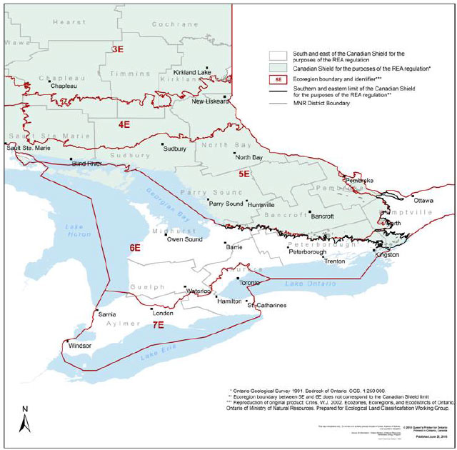
- Significant woodlands have development prohibitions only on lands that are located south and east of the of the Canadian Shield
footnote 10 line (Figure 1); and - Provincially significant northern and provincially significant southern wetlands, defined by the northern limit of Ecoregion 5E (Figure 1), have differing development prohibitions established in the REA Regulation (Table 2).
Applicants undertaking a NHA may have to determine the exact location of these lines on the basis of provincial-scale information, to identify the development prohibitions that apply where their project is proposed. In cases where either line bisects a natural feature, the development prohibitions that apply within Ecoregions 5E, 6E and 7E, and south and east of the Canadian Shield shall be applied for the entire feature.
Detailed mapping (1:10, [Ontario Base Map]) of these lines is available in digital format or a paper medium from MNR and a shape file of t000he ecoregion boundaries is available from the Ontario Land Information Warehouse (Appendix B.1.1). For interpreting the Canadian Shield line on a project-specific basis, the MRD219 - Paleozoic Geology of Southern Ontario data layer administered by the Ministry of Mines can be used to derive the boundary (Appendix B.1.4).
Figure 1: Canadian Shield and Ecoregion Line
Enlarge Figure 1: Canadian Shield and Ecoregion Line
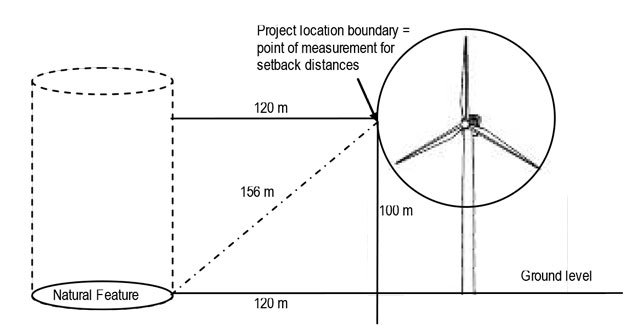
2.3 The meaning of “project location”
Many of the requirements of the NHA are based on measurements from the outer limit of the renewable energy “project location” to the boundaries of natural features. As per the definition in the REA regulation, a renewable energy project location includes: “…a part of land and all or part of any building or structure in, on or over which a person is engaging in or proposes to engage in the project and any air space in which a person is engaging in or proposes to engage in the project”.
A renewable energy project includes all activities associated with the construction, installation, use, operation, maintenance, changing or retiring of the renewable energy generation facility. Therefore, for the purposes of measuring the distance from the project location to a natural feature, a project location boundary is considered to be the outer limit where site preparation and construction activities (e.g. vegetation removal) will occur and where infrastructure will be located (e.g. temporary structures, lay down areas, storage facilities, generation equipment, access roads, transmission lines less than 50 kilometres in length, etc.).
Measurement from the project location boundary to the feature must be made from the outer limit of the project location along a horizontal plane to the boundary of the natural feature. As the renewable energy project location includes air space that the project occupies, the outer boundary of a project location may be above ground level. The measurement decision is based on whichever activity or structure extends the project location furthest.
As an example, Figure 2 and Figure 3 depict the measurement between a project location and a natural feature where the outer limit of the project location is the extent of the staging area used for construction or installation of the project. Alternatively, Figure 4 depicts a scenario where the blade of a wind turbine is the outer limit of the project location, and therefore used for measurement. The diagonal distance from blade tip to the natural feature at ground level is depicted to illustrate the difference between the diagonal and horizontal distance and to demonstrate why the diagonal measurement is not permitted (i.e. if the diagonal measurement was equal to 120 metres, the horizontal measurement would equal only 66 metres in this example).
Figure 2: Project location boundary where construction area is furthest
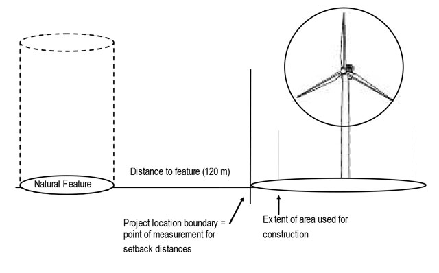
Figure 3: Project location boundary where construction area is furthest
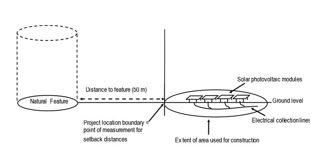
Figure 4: Project location boundary where blade tip is furthest
3.0 Natural Heritage Assessment
3.1 Overview of the natural heritage assessment
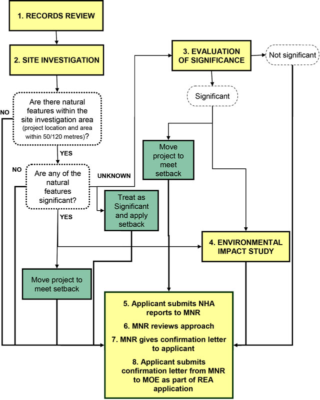
NHA requirements are outlined in the REA Regulation in part IV, Sections 24-28. Figure 5 provides a flowchart of the NHA process.
The NHA begins with a records review to identify any known or potential natural features present at and within 120 metres of the proposed project location, and a site investigation to verify those features and identify any additional natural features. The site investigation area includes the area at the project location and the area within 50 metres or 120 metres of the proposed project location, based on the project component(s) and type of development being proposed. For more information on the records review and site investigation, see Section 4 and Section 5.
Where a natural feature is present within the site investigation area, the applicant must determine if the natural feature is significant or provincially significant, to ascertain whether the development prohibitions in Table 2 apply.
The development prohibitions specific to natural features in the Oak Ridges Moraine Conservation Plan Area or the Natural Heritage System of the Greenbelt Plan’s Protected Countryside Area (outlined in Table 4) apply regardless of significance.
If the natural feature has previously been evaluated by MNR and that evaluation determined the feature to be significant or provincially significant, the development prohibitions apply. If the natural feature has not been evaluated, the applicant must determine the significance of the feature to ascertain whether development prohibitions apply, or protect the feature by treating it as significant and amending the proposed project location to be outside the established setback from the feature. If choosing to apply the setback, the applicant does not need to complete an evaluation of significance or any other natural heritage study for that feature.
Applicants can determine the significance of an unevaluated natural feature by applying evaluation criteria or procedures set out in the Guide (Section 6); or by referencing a previousevaluation (e.g. by a municipal planning authority), provided the evaluation was completed using criteria or procedures established or accepted by MNR. If it is determined that the feature is not significant or provincially significant, development prohibitions do not apply.
Where it is determined that a natural feature is significant or provincially significant, applicants may seek an exception from the prohibitions, in order to develop within the natural feature and setback, provided an EIS is prepared in accordance with procedures set out in the Guide (Section 7).
3.2 MNR confirmation of the Natural Heritage Assessment
As part of the NHA, applicants are required to prepare a Records Review Report and Site Investigation Report and may be required to prepare Evaluation of Significance Report(s) and EIS Report(s).
In addition to the NHA requirements, under part IV, Section 23.1 of the REA Regulation applicants proposing wind power projects are required to prepare an Environmental Effects Monitoring Plan in respect of birds and bats
Under the REA Regulation (part IV, Section 28), any reports prepared as part of the NHA as well as the Environmental Effects Monitoring Plan in respect of birds and bats (if applicable) must be provided to MNR for review, prior to the submission of an application to MOE for a REA. MNR will conduct a review to determine whether the reports and plans have been prepared in accordance with the Guide.
As part of the REA application to the MOE, the applicant must submit the following, obtained in writing from MNR:
- Confirmation that the determination of the existence of natural features and the boundaries of natural features was made in accordance with the Guide;
- Confirmation that the site investigation and records review were conducted in accordance with the Guide, if no natural features were identified;
- Confirmation that the evaluation of the significance or provincial significance of the natural features was conducted in accordance with the Guide;
- Confirmation of the project location in relation to provincial parks or conservation reserves;
- Confirmation that if the project location is proposed in a provincial park or conservation reserve, it is not prohibited by or under the Provincial Parks and Conservation Reserves Act, 2006;
- Any additional written comments provided by MNR in respect of the NHA; and
- Comments in respect of the Environmental Effects Monitoring Plan in respect of birds and bats (if applicable).
Where the MNR review finds that the NHA has been completed in accordance with the Guide, the applicant will be provided with a letter of confirmation. MNR may also provide additional written comments related to the NHA that the applicant should consider. These comments may refer to the acceptability of the procedures undertaken or the accuracy of results, and may include specific recommendations for MOE to consider as conditions of approval on the REA. If an Environmental Effects Monitoring Plan in respect of birds and bats is required, MNR will provide the applicant with written comments in respect of the plan.
Applicants are encouraged to work with MNR throughout the NHA process, as staff may be able to provide interim advice on reports to ensure that all necessary information is included, procedures have been undertaken correctly and findings are accurate. Interim advice may expedite MNR’s review and confirmation of the complete NHA.
3.3 Project changes
Applicants wishing to make project design changes after providing NHA reports or the Environmental Effects Monitoring Plan to MNR for review are advised to contact MNR as early as possible, to determine the most efficient approach for incorporating the changes into their submission.
Where the applicant has already obtained written confirmation and comments, MNR should be contacted to discuss whether the NHA and the Environmental Effects Monitoring Plan will be affected by the proposed project changes.
Applicants should provide MNR with a description and rationale for the proposed changes, and identify whether, and if so how, any previous studies, evaluations, reports, and plans would be affected as a result of the proposed changes. Once the proponent has provided MNR with all necessary information, MNR will assess the extent of the proposed changes to determine if further work is necessary to meet the requirements of the REA regulation (e.g. additional field studies).
After review, if MNR determines that further work is not required the applicant will be provided with a letter which states that nothing further is required beyond the original confirmation and comments.
Where MNR determines the need for further work, applicants will be required to provide MNR with the necessary information, studies, or reports to ensure that the requirements of the REA Regulation are met. Once the requirements are met, MNR will provide the applicant with an addendum to the original confirmation and comments, which is specific to the proposed project changes. The addendum must be submitted to MOE at the time of REA application, along with the original confirmation and comments
In all cases, applicants will need to align with the broader project change provisions of the REA Regulation, including any requirements with regard to additional notification or consultations. For further information on making changes to a renewable energy project, applicants should contact the MOE.
3.4 REA regulation amendment transition provisions
The MOE has amended the REA Regulation on three separate occasions: January 1, 2011, July 1, 2012, and November 2, 2012. The information presented in the Guide is consistent with the November 2, 2012 version of the regulation and the NHA requirements therein.
The MOE has outlined transition provisions under Sections 61 and 62 of the REA Regulation. Depending upon which eligibility criteria a project meets under the transition provisions, flexibility has been provided to follow the requirements of the pre-2011 regulation (including the ability to elect into the January 1, 2011 version) or the regulation as amended January 1, 2011. Projects eligible to follow the requirements of these previous versions may also elect to follow the July 1, 2012 REA Regulation; however, this choice will remove the flexibility to work under previous versions. Projects without eligibility under the transition provisions are required to follow the July 1, 2012 regulation. Transition provisions for the amendments of November 2, 2012 were not specified; therefore the amendments applied to all unapproved projects upon coming into force. For further information about the transition provisions and to determine eligibility to work under previous versions, applicants should contact the MOE.
With regard to the completion of the NHA, the REA Regulation amendments of January 1, 2011 included requirements related to the Environmental Effects Monitoring Plan for birds and bats under Section 23.1 of the REA Regulation, as well as an updated definition for woodlands. Applicants with projects eligible to follow the requirements of the pre-2011 REA Regulation are advised that electing to follow any provisions of the amended July 1, 2012 regulation will remove pre-2011 flexibility
MNR regarding the Environmental Effects Monitoring Plan in respect of birds and bats as part of the REA submission and may elect to use the pre-2011 definition of woodlands during the NHA.
Figure 5: Natural Heritage Assessment process flowchart
3.5 Coordinating natural heritage assessment work with mnr permits and approvals
In addition to reviewing and confirming the NHA, MNR is responsible for issuing a variety of other permits and approvals under various pieces of legislation including the Public Lands Act, Endangered Species Act, Fish and Wildlife Conservation Act, and Provincial Parks and Conservation Reserves Act.
These permits and approvals are outlined in MNR’s Approval and Permitting Requirements Document for Renewable Energy Projects (APRD)
Applicants are encouraged to identify where efficiencies can be achieved by coordinating work for NHA and APRD requirements (e.g. records review, site investigation). Opportunities for coordination may be identified through consultation with MNR.
4.0 Records review
The records review is the initial stage of a NHA, and is required under Part IV, Section 25 of the REA Regulation. The purpose of the records review is for the applicant to gather information about the area in which a project location is proposed, identify natural features, and make preliminary determinations about site feasibility. The applicant is required to search and analyze records which may identify known or potential natural features that will require further verification and assessment through the site investigation. Any information obtained through the records review about previous determinations of the significance of natural features will contribute to subsequent stages of the NHA (e.g. evaluation of significance, EIS Report), should these stages become necessary (Section 6 and Section 7).
The REA Regulation requires applicants to undertake a records review for the proposed project location and the area within 120 metres of the proposed project location. MNR encourages applicants to consider collecting and searching records for an area wider than that required by regulation (one kilometre is recommended) to accommodate any potential changes to project design or layout that may occur later in the project planning stages. This broader approach will reduce the potential for delays resulting from the need to undertake a second records review for a larger area in later stages.
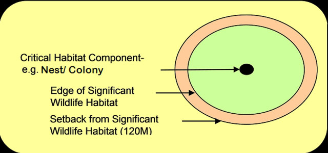
Expanding the records review area has particular relevance for wildlife habitat. Wildlife habitat data collected during the records review will frequently identify critical habitat components (e.g. bat hibernacula, bald eagle nest), which appear as points on a map (Figure 6). While these critical habitat components may originate further than 120 metres from the project location, they will often have associated candidate or confirmed significant wildlife habitat (see Appendix E for a glossary of terms) which extends well beyond the point location itself. During the records review, applicants should identify habitat components and any associated candidate or confirmed significant wildlife habitat that may extend to or within 120 metres of the project location.
Figure 6: Wildlife critical habitat component point
Information sources that must be searched as part of a records review are outlined in Table 6. In locations where little information about natural features is available, applicants can use the records review to assemble general information about the project location and potential natural features, before progressing to the site investigation stage.
Table 6: Records to be searched and analyzed in a records review
| Records to be searched - records that relate to provincial parks and conservation reserves maintained by | Analysis to be undertaken |
|---|---|
| Ministry of Natural Resources | Analysis of MNR records related to the boundaries of provincial parks and conservation reserves is required to determine park or conservation reserve boundaries and whether the project location is proposed within the boundary or 120 m of the boundary |
| Records that relate to natural features maintained by: (See Appendix B for further information) | Analysis to be undertaken |
|---|---|
| Ministry of Natural Resources | Analysis of records is required to determine if the project location is proposed:
|
| Federal Government | Analysis of records is required to determine if the project location is proposed:
|
| Conservation Authority (if any part of the project location is in the area of jurisdiction of the conservation authority) | Analysis of records is required to determine if the project location is proposed:
|
| Municipal planning authority or local planning board | Analysis of records is required to determine if the project location is proposed:
|
| Local and upper-tier municipalities | Analysis of records is required to determine if the project location is proposed:
|
| Local roads board | Analysis of records is required to determine if the project location is proposed:
|
| Local Services Board | Analysis of records is required to determine if the project location is proposed:
|
| Niagara Escarpment Commission (if any part of the project location is proposed in the Niagara Escarpment Plan Area) | Analysis of records is required to determine if the project location is proposed:
|
4.1 Records review report
The applicant must prepare a Records Review Report that summarizes the records searched and the results of analysis, including the following information:
- Description of all records reviewed (e.g. titles of datasets, data layers, map titles etc.);
- Relevant supporting metadata (e.g. vintage or date of information that was searched or collected, ownership of the information, etc.);
- List of the organizations contacted;
- Whether the proposed project location is in a natural feature, within 50 metres of an ANSI (earth science), or within 120 metres of a natural feature that is not an ANSI (earth science);
- Whether the proposed project location is in a provincial park or conservation reserve or within 120 metres of a provincial park or conservation reserve; and
- If the project in proposed within a provincial park or conservation reserve, evidence that the project is permitted under Section 19 of the Provincial Parks and Conservation Reserves Act, 2006
It is recommended that applicants use a Geographic Information System (GIS) to perform the records review, and include a map product in an electronic format with the Records Review Report. This initial map will support the mapping required during the site investigation stage. For records review mapping standards, applicants should apply the recommendations provided for the site investigation map (Section 5.11.1).
4.2 Information sources for a records review
To receive MNR confirmation of the records review, applicants shall collect, search and analyze, at a minimum, records maintained by the organizations listed in Table 6. While these records are to be searched as part of a records review, this information can also inform other aspects of the NHA. Additional information sources such as local naturalist groups, local fish and game clubs, or academic institutions may also be consulted.
See Table 7 for a list of MNR resources which applicants should consult when undertaking a records review and links to additional information. See Appendix B for further information regarding resources sourced from other organizations and agencies.
Table 7: MNR Resources for Conducting a Records Review footnote 17
| MNR Resources (for descriptions and direction on use see Appendix B.1) | MNR Resources (for descriptions and direction on use see Appendix B.1) | NHA Records Review Relevancy - Wetlands | NHA Records Review Relevancy - Woodlands | NHA Records Review Relevancy - Wildlife Habitat | NHA Records Review Relevancy - Areas of Natural and Scientific Interest | NHA Records Review Relevancy - Savannahs/Sand/Barrens/Tallgrass/Prairies | NHA Records Review Relevancy - Alvars | NHA Records Review Relevancy - Provincial Parks and Conservation Reserves |
|---|---|---|---|---|---|---|---|---|
| MNR | MNR work centres | Yes | Yes | Yes | Yes | Yes | Yes | Yes |
| MNR | Land Information Ontario | Yes | Yes | Yes | Yes | Yes | Yes | Yes |
| MNR | Natural Heritage Information Centre | Yes | Yes | Yes | Yes | Yes | Yes | N/A |
| MNR | Ontario Parks | N/A | N/A | N/A | N/A | N/A | N/A | Yes |
| MNR Manuals / Guidelines | Ecological Land Classification Manuals | Yes | Yes | Yes | N/A | Yes | Yes | N/A |
| MNR Manuals / Guidelines | MNR Birds and Bird Habitats; and Bats and Bat Habitats: Guidelines for Wind Power Projects | N/A | N/A | Yes | N/A | N/A | N/A | N/A |
| MNR Manuals / Guidelines | Ontario Wetland Evaluation System Manuals | Yes | N/A | N/A | N/A | N/A | N/A | N/A |
| MNR Manuals / Guidelines | Significant Wildlife Habitat Technical Guide & Appendixes | N/A | N/A | Yes | N/A | N/A | N/A | N/A |
| MNR Manuals / Guidelines | Significant Wildlife Habitat Eco-regional Criteria Schedules | N/A | N/A | Yes | N/A | N/A | N/A | N/A |
| MNR Data Layers | ANSI Data Layer | N/A | N/A | N/A | Yes | N/A | N/A | N/A |
| MNR Data Layers | Conservation Reserve Regulated Data Layer | N/A | N/A | N/A | N/A | N/A | N/A | Yes |
| MNR Data Layers | Digital Elevation Model – Version 2.0.0 – Provincial Tiled Data Layer | N/A | Yes | N/A | N/A | N/A | N/A | N/A |
| MNR Data Layers | Forest Cover – Forest Resources Inventory Unit | N/A | N/A | Yes | N/A | N/A | N/A | N/A |
| MNR Data Layers | OHN - Waterbody Data Layer | N/A | Yes | N/A | N/A | N/A | N/A | N/A |
| MNR Data Layers | OHN - Watercourse Data Layer | N/A | Yes | N/A | N/A | N/A | N/A | N/A |
| MNR Data Layers | Provincial Park Regulated Data Layer | N/A | N/A | N/A | N/A | N/A | N/A | Yes |
| MNR Data Layers | Significant Ecological Area Data Layer | N/A | Yes | Yes | N/A | N/A | N/A | N/A |
| MNR Data Layers | Southern Ontario Land Resource Information System | Yes | Yes | Yes | N/A | Yes | Yes | N/A |
| MNR Data Layers | Various Wildlife Land Information Ontario Data Layers | N/A | N/A | Yes | N/A | N/A | N/A | N/A |
| MNR Data Layers | Water Virtual Flow – Seamless Provincial Data Layer | N/A | Yes | N/A | N/A | N/A | N/A | N/A |
| MNR Data Layers | Wetland Data Layer | Yes | Yes | Yes | N/A | N/A | N/A | N/A |
| MNR Data Layers | Wooded Area Data Layer | N/A | N/A | Yes | Yes | N/A | N/A | N/A |
Applicants are advised to collect and analyze records from Land Information Ontario (LIO), Natural Heritage Information Centre (NHIC), and public organizations prior to seeking information from MNR. MNR will then be able to supplement this information and provide any necessary additions.
Applicants may be required to sign data licence agreements with both LIO and NHIC
In some cases, applicants will be required to undergo data sensitivity training in order to access detailed information on sensitive data. Training can be provided by MNR regional or district offices, or by contacting NHIC (Appendix B.1.1).
5.0 Site investigation
The site investigation is the second stage of a NHA, as required under Part IV, Section 26 of the REA Regulation. The site investigation confirms the presence and boundaries of natural features within the site investigation area for the project location. The applicant must verify the accuracy of the Records Review Report while identifying any additional natural features not identified through the records review. It is the responsibility of the applicant to ensure that a site investigation is conducted, either by visiting the site or through an alternative investigation (Section 5.3), and to submit a report which documents the details of that investigation. The site investigation should be conducted by qualified professionals.
5.1 Determining the site investigation area
Under the REA Regulation, the site investigation area includes the entirety of the project location itself. However, the required extent of the site investigation area around the project location will vary between either 50 metres or 120 metres, based on each project location component around which the applicant is conducting the investigation (e.g. turbine, transmission line, laydown area) and the type of development proposed (i.e. construction, installation, or expansion). Site investigation area requirements are outlined in Table 8 and Table 9.
Table 8: Site investigation area for solar projects
| Project location component | Site investigation area |
|---|---|
| Construction, installation or expansion of a solar facility (all project components) | At and within 50 m of the project location |
Table 9: Site investigation area for wind & bioenergy projects
| Project location component | Site investigation area |
|---|---|
| Construction, installation or expansion of a transmission or distribution line | At and within 50 m of project location component |
| Expansion of an existing transformer station or distribution station | At and within 50 m of project location component |
| Expansion of an existing transportation system | At and within 50 m of project location component |
| General development (i.e. all other types of construction, installation, or expansion) | At and within 120 m of project location components |
It is recommended that the site investigation area be expanded to an area large enough to accommodate any potential changes to project design or layout that may occur later in the project planning stages. This will reduce the potential for delays resulting from needing to undertake a second site investigation for a larger area in later stages.
5.2 Conducting the site investigation
Applicants are encouraged to contact MNR to ensure that the records review portion of the NHA is accurate and complete prior to beginning a site investigation. MNR may also be able to provide applicants with advice on the site investigation work plan and methodology.
A site investigation includes an investigation of the air, land and water within the site investigation area to:
- verify whether the analysis of the project location undertaken through the records review is accurate, and make any necessary corrections to the determinations in the Records Review Report;
- determine whether any additional natural features exist within the site investigation area, other than those identified in the Records Review Report;
- determine the boundaries of any natural feature located within the site investigation area (identified through the Records Review Report or during site investigation); and
- determine the distance from the project location to the boundaries of any natural features
For each natural feature identified during the records review, and any additional natural featuresidentified during the site investigation, the applicant must also provide information which establishes the type of feature. To ensure that this information is accurately assessed, it is important that fieldwork, where applicable, be conducted at times which are seasonally appropriate for the natural features being studied. This information must be included in the Site Investigation Report (Section 5.11).
Although it is not required that applicants evaluate the significance of natural features at the time of the site investigation, it is recommended that applicants understand the criteria for evaluating the significance of natural features (e.g. attributes, composition, function) prior to the site investigation (Section 6). This will ensure that boundaries of natural features are clearly identified and that the site investigation is scoped appropriately to identify all natural features within the site investigation area. Likewise, additional field work which may be necessary to prepare an EIS Report (Section 7 and Appendix A.2.1) should be considered at the time of site investigation.
5.3 Alternative investigation
Under Part IV, Section 26(1.1) of the REA Regulation, an alternative investigation may be conducted if the applicant determines that it is not reasonable to visit a site (a part of air, land or water within the site investigation area) to conduct a site investigation. An alternative investigation must verify the accuracy of the Records Review Report while identifying any additional natural features not identified through the records review. In the Site Investigation Report, the applicant must provide an explanation of the factors considered in making the determination that it was not reasonable to visit the site (Section 5.11).
Table 10 provides examples of situations wherein visiting a site for the purposes of conducting a site investigation would not be reasonable, as well as information which is required to be provided in the Site Investigation Report to support the determination. The examples are not exhaustive; however, they represent commonly encountered scenarios.
To ensure that the rationale for undertaking an alternative investigation of the site is accepted and the confirmation of the Site Investigation Report is not affected, applicants are advised to discuss the alternative investigation rationale and approach with MNR prior to proceeding.
In all cases, applicants must be able to provide rationale for determining that a site is not reasonable to visit, a description of efforts to access the site, and associated documentation.
Table 10: Examples of rationale for alternative investigations
| Rationale for alternative investigation | Supporting information (site in vestigation report) |
|---|---|
| Access to a site not granted by adjacent landowner |
|
| Visiting a site is unsafe (e.g. natural hazard, unstable soils) |
|
The determinations required under Section 26 of the REA Regulation continue to apply to alternative investigations, as well as specific requirements of the Site Investigation Report (Section 5.11). Likewise, the direction and resources presented in upcoming sections of the Guide which assist with natural feature specific site investigations remain relevant, and should be consulted.
Procedures and methodology for identifying natural features and boundaries during an alternative investigation should be discussed with MNR. In most cases, an alternative investigation will be best conducted through analysis of ortho-rectified aerial photographs verified with observations, where possible, from the project location and fenceline or roadside observations.
5.4 Ecological land classification
Ecological land classification (ELC) is the recommended methodology for efficiently and cost-effectively identifying natural features and delineating boundaries. Applicants should consider conducting an ELC assessment as a component of a site investigation or alternative investigation. The ELC assessment can also be used as the basis for the creation of the site investigation map. Applicants are advised to contact the local conservation authority office (where one exists), as the authority may have already conducted ELC assessment and mapping (Appendix B.1.2).
An ELC assessment begins with the classification of lands within the site investigation area, using the Provincial ELC system. It is recommended that lands be classified to the vegetation type where possible, to allow for the identification of rare vegetation communities. The ELC assessment can be done through a mapping, aerial photographing and/or GIS exercise, and confirmed during the site investigation. Where it is not reasonable to visit the site, applicants are encouraged to complete the desktop portion of an ELC assessment as part of an alternative investigation.
Where the Provincial ELC System is not available, the approach to the assessment depends on the geographic location (Ecoregion) in which the renewable energy project is proposed:
- In Ecoregions 6E and 7E, the Southern Ontario ELC system can be used to identify ecosites;
- In more northern regions (Boreal and Great Lakes St. Lawrence regions) the Provincial ELC System is available; however, the Forest Ecosystem Classification (FEC) systems can also be used for forested habitats; and
- In non-forested northern habitats (e.g. sand barrens, rock barrens, prairie, alvar, beach/bar, cultural communities) the Southern Ontario ELC system can be used, as well as the Terrestrial and Wetland Ecosites of Northwestern Ontario field guide; however, this is less suitable because it is not as detailed as the southern ELC system.
For descriptions of ELC manuals and their application, as well as a link to the Ecological Land Classification Primer, see Appendix B.1.3.
5.5 Wetlands and coastal wetlands
The REA Regulation defines a wetland as land such as a swamp, marsh, bog or fen, other than land that is being used for agricultural purposes and no longer exhibits wetland characteristics, that:
- is seasonally or permanently covered by shallow water or has the water table close to or at the surface; and
- has hydric soils and vegetation dominated by hydrophytic or water-tolerant plants.
When conducting site investigations for wetlands, applicants must verify the boundaries of any wetlands identified through the records review, and establish the presence of any additional wetlands within the site investigation area, and their boundaries. Accurately mapping the extent of wetlands as part of the Site Investigation Report is crucial, and may require the delineation of wetland complexes. Identification of wetland complexes is based on an examination of a variety of criteria (e.g. distance). MNR may be able to provide applicants with existing mapping or other information concerning the extent of wetlands identified at or within the site investigation area.
Procedures for conducting site investigations of wetlands are found in the Ontario Wetland Evaluation System Manuals (OWES). There are two OWES manuals: one for Southern Ontario (to evaluate wetlands in Ecoregions 6 and 7) and one for Northern Ontario (to evaluate wetlands in Ecoregions 2, 3, 4, and 5). Both manuals apply to coastal wetlands in the respective areas. Applicants should ensure that the most current version of the appropriate OWES manual is consulted.
Where not previously delineated by MNR staff, wetlands can be delineated by other qualified professionals, provided they use the approved OWES methodology and have completed an MNR- sanctioned OWES training course. Although potential wetlands may be initially recognized through another process (e.g. ELC), OWES training is required to officially identify wetlands and verify the locations of their outer boundaries.
MNR is responsible for confirming the qualifications and methods of the person conducting the investigation. MNR recognizes only ministry-sanctioned OWES training courses. Site investigations conducted by individua ls trained by other organizations will not be considered. MNR routinely offers OWES training courses (see Appendix B.1.3).
The table below provides brief descriptions of resources for conducting site investigations of wetlands. Further descriptions are provided in Appendix B.1.
| Resource | Relevant site investigation information |
|---|---|
| Ontario Wetland Evaluation System Manuals – North and South |
|
| Conservation Authorities |
|
5.6 Woodlands
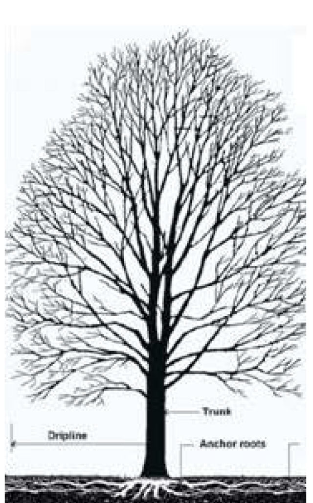
The REA Regulation defines a “woodland” as a treed area, woodlot or forested area, other than a cultivated fruit or nut orchard or a plantation established for the purpose of producing Christmas trees, that is located south and east of the Canadian Shield (Figure 1). When conducting site investigations for woodlands, applicants must verify the boundaries of woodlands identified through the records review and establish the presence of any additional woodlands and their boundaries. Woodland boundaries should be delineated using the outer edge of the dripline as a measuring point (Figure 7).
Figure 7: Delineation of woodlands using dripline
Treed areas separated by small openings are considered to be single woodlands. A bisecting opening 20 metres or less in width between crown edges is not considered to divide a woodland into two separate woodlands and the area of the developed opening (e.g. maintained public road or rail line) is not included in the woodland area calculation.
The table below provides brief descriptions of resources for conducting site investigations of woodlands. Further descriptions are provided in Appendix B.1.
| Resource | Relevant site investigation information |
|---|---|
| Oak Ridges Moraine Conservation Plan Technical Paper Series #7 |
|
| Ecological Land Classification Manuals |
|
5.7 Wildlife habitat
The definition of wildlife habitat in the REA Regulation applies province-wide and includes an area:
- where plants, animals and other organisms live or have the potential to live and find adequate amounts of food, water, shelter and space to sustain their population, including;
- where a species concentrates at a vulnerable point in its annual or life cycle; and
- important to a migratory or non-migratory species
Site investigation for wildlife habitat should be scoped to include only candidate and confirmed significant wildlife habitat. Confirmed significant wildlife habitat may be identified during the records review, while candidate significant wildlife habitat is usually identified during the site investigation.
Prior to applying the site investigation methodologies for wildlife habitat outlined below, applicants should consult the Process for Identifying and Addressing Significant Wildlife Habitat (Appendix D). MNR has established the process to provide applicants with a step by step streamlined process for applying the wildlife habitat site investigation, evaluation of significance, and EIS procedures found in the Guide.
5.7.1 Identification of candidate significant wildlife habitat
Applicants should begin the site investigation process by identifying candidate significant wildlife habitat (i.e. potentially significant) within the site investigation area. MNR’s established procedures for identifying candidate significant wildlife habitat include conducting an ELC assessment of ecosites and consulting MNR’s Significant Wildlife Habitat Technical Guide
5.7.1.1 Ecological land classification
The determination of the presence or absence of candidate significant wildlife habitat can be assisted through the identification and delineation of ELC ecosites. This assessment supports the processes for identifying candidate significant wildlife habitat contained in the Significant Wildlife Habitat Technical Guide.
To complete an ELC assessment of ecosites for candidate significant wildlife habitat, applicants can build on the general ELC assessment process outlined in Section 5.4.The ELC manuals provide a process for identifying and delineating ecologically based land units, to determine the potential for a specific wildlife habitat to exist within a given ecoregion.
Where the identification of rare vegetation communities and specialized habitats requires habitats to be classified to the vegetation type, the appropriate Ecoregional FEC system or the Southern Ontario ELC system will need to be consulted. The Provincial ELC system currently does not contain detailed information on vegetation types.
For further descriptions of the ELC manuals and their application, as well as a link to the Ecological Land Classification Primer, see Appendix B.1.3.
5.7.1.2 Significant wildlife habitat technical guide
The Significant Wildlife Habitat Technical Guide (Appendix B.1.3) establishes criteria to determine the significance of wildlife habitat, and provides direction on determining the extent of candidate significant wildlife habitat associated with critical habitat components. The Significant Wildlife Habitat Technical Guide also provides direction for identifying candidate significant wildlife habitat during the site investigation itself. Some candidate significant wildlife habitat can only be discovered through site investigation (e.g. rock piles).
To ensure a comprehensive approach to identifying and evaluating wildlife habitat, the Significant Wildlife Habitat Technical Guide describes four broad categories of significant wildlife habitat:
- Habitats of seasonal concentrations of animals:
- areas where animals occur in relatively high densities for the species at specific periods in their life cycles and/or in particular seasons
- seasonal concentration areas, which tend to be localized and relatively small in relation to the area of habitat used at other times of the year
- Rare vegetation communities or specialized habitat for wildlife:
- rare vegetation communities include:
- areas that contain a provincially rare vegetation community
- areas that contain a vegetation community that is rare within the planning area
- specialized wildlife habitats include:
- areas that support wildlife species that have highly specific habitat requirements
- areas with exceptionally high species diversity or community diversity
- areas that provide habitat that greatly enhances species’ survival
- rare vegetation communities include:
- Habitat of species of conservation concern:
- includes the habitat of species that are rare or substantially declining, or have a high percentage of their global population in Ontario and are rare or uncommon in the planning area
- species that are rare within the planning area, even though they may not be provincially rare
- includes special concern species identified under the ESA on the SARO List, which were formally referred to as “vulnerable” in the Significant Wildlife Habitat Technical Guide
- species that are listed as rare or historical in Ontario based on records kept by the Natural Heritage Information Centre (S1 is extremely rare, S2 is very rare, S3 is rare to uncommon)
- species identified as nationally endangered or threatened by the Committee on the Status of Endangered Wildlife in Canada, which are not protected in regulation under Ontario’s ESA
- excludes habitats of endangered and threatened species
- Animal movement corridors:
- habitats that link two or more wildlife habitats that are critical to the maintenance of a population of a particular species or group of species
- habitats with a key ecological function to enable wildlife to move, with minimum mortality, between areas of significant wildlife habitat or core natural areas
5.7.1.3 Significant wildlife habitat eco-regional criteria schedules
In recognition of the variability of the Ontario landscape, MNR has created Significant Wildlife Habitat Eco-regional Criteria Schedules to support the Significant Wildlife Habitat Technical Guide and provide an effective and efficient format for identifying candidate significant wildlife habitat. The schedules are not replacements, but companion documents which present the significance criteria for identifying candidate significant wildlife habitat in a way which is reflective of the Significant Wildlife Habitat
Technical Guide, yet specific to the geographic area of each ecoregion.
Applicants should refer to any eco-regional criteria schedules approved for use by MNR (Appendix B.1.3). In ecoregions where schedules are not available, the Significant Wildlife Habitat Technical Guide should continue to be used until schedules are developed.
5.7.2 Site investigation for confirmed and candidate significant wildlife habitat
Once any candidate significant wildlife habitats have been identified, the applicant should conduct the site investigation. To meet the requirements of the Site Investigation Report (Section 5.11) the investigation should be scoped to include the following:
- confirmed significant wildlife habitat identified through the records review;
- candidate significant wildlife habitat identified using the Significant Wildlife Habitat Technical Guide, ELC manuals, and Significant Wildlife Habitat Eco-regional Criteria Schedules; and
- candidate significant wildlife habitat discovered during site investigation
The table below provides brief descriptions of resources for conducting site investigations of wildlife habitat. Further descriptions are provided in Appendix B.1.
| Resource | Relevant site investigation information |
|---|---|
| Ecological Land Classification Manuals |
|
| Significant Wildlife Habitat Technical Guide & Appendices |
|
| Significant Wildlife Habitat Eco-regional Criteria Schedules |
|
| MNR Birds and Bird Habitats: Guidelines for Wind Power Projects; and MNR Bats and Bat Habitats: Guidelines for Wind Power Projects |
|
5.8 Areas of natural and scientific interest
Under the REA Regulation, Areas of Natural and Scientific Interest (ANSIs) are defined as areas which have values related to protection, scientific study or education. ANSIs are areas of land and water containing natural landscapes or featuresidentified by MNR as life science and/or earth science sites (or both) depending on natural heritage values.
ANSIs are identified systematically based on established science criteria, and contribute to the natural features and landscapes of Ontario. MNR assesses ANSIs as being provincially, regionally or locally significant. To date, more than 500 provincially significant ANSIs have been confirmed.
When conducting site investigations for ANSIs, applicants must confirm the presence and boundaries of all ANSIs identified through the records review. The boundaries of an ANSI can only be changed by MNR, using the ANSI Identification and Confirmation Procedure.
With the exception of specified provincial plan areas (Table 4), only ANSIs confirmed by MNR as provincially significant are afforded protection through the REA Regulation. Applicants are not required to identify additional ANSIs during the site investigation.
The table below provides brief descriptions of resources for conducting site investigations of ANSIs. Further descriptions are provided in Appendix B.1.
| Resource | Relevant site investigation information |
|---|---|
| MNR work centres |
|
| Identification and Confirmation Procedure for Areas of Natural and Scientific Interest |
|
5.9 Natural features in specified provincial plan areas
Project locations which are proposed in the Oak Ridges Moraine Plan Area or the Greenbelt Plan’s Natural Heritage System require the identification of additional natural features during the records review, including sand barrens, savannahs, tallgrass prairies, and alvars.
When conducting site investigations for natural features in the Oak Ridges Moraine Plan Area or the Greenbelt Plan’s Protected Countryside Area, applicants must also verify the boundaries of any sand barrens, savannahs, tallgrass prairies, and alvars identified through the records review and establish any additional instances of these natural features and their boundaries.
The table below provides brief descriptions of resources for conducting site investigations of sand barrens, savannahs, tallgrass prairies, and alvars. Further descriptions are provided in Appendix B.1.
| Resource | Relevant site investigation information |
|---|---|
| Ecological Land Classification Manuals |
|
| Oak Ridges Moraine Conservation Plan Technical Paper Series #1 |
|
5.10 Provincial parks and conservation reserves
Where a project location is proposed within the setback of a natural feature which is inside a provincial park or conservation reserve, the park superintendent or conservation reserve manager should be contacted prior to undertaking site investigations, as a permit may be required. Applicants should work with staff to confirm provincial park or conservation reserve boundaries in relation to the project location (Appendix B.1.1).
Applicants proposing projects within the setback of a provincial park or conservation reserve will have to address the potential negative environmental effects to the provincial park or conservation reserve itself, through an EIS (Section 7.4). Applicants should consider discussing the features, functions and values of the protected area, as well as any field work required to complete an EIS during the site investigation stage.
| Protected area | Site investigation resource |
|---|---|
| Provincial Parks | Ontario Parks |
| Conservation Reserves | MNR work centres |
5.11 Site investigation report
The applicant must submit a Site Investigation Report to MNR for confirmation as outlined in Part IV, Section 28 of the REA Regulation. The report summarizes the results of the site investigation or alternative investigation and details the methods and procedures used.
The Site Investigation Report must include:
- summary and rationale of any corrections that were made to the records review upon performing the site investigation (e.g. a natural feature was identified during the site investigation that was not identified during the records review);
- information relating to each natural feature identified in the records review and in the site investigation that is needed to confirm the presence of the feature, its type (e.g. woodland), as well as its significance (if known) and any supporting rationale, including any information required in Appendix C or Appendix D of the Guide (where applicable)
- summary of methods used to make observations during the site investigation; and
name and qualifications of any person conducting site investigation
If an investigation was conducted by visiting the site:
- dates and times of the beginning and completion of the site investigation;
- duration of the site investigation;
- weather conditions during the site investigation (include field observations and data collected from Environment Canada weather station closest to project location); and
- field notes kept by the person(s) conducting the site investigation (including field data sheets, ELC field cards, and survey forms)
If an alternative investigation of the site was conducted:
- the dates of the generation of the data used in the alternative site investigation; and
- an explanation of the factors considered in making the determination that it was not reasonable to visit the site
5.11.1 Site investigation map
As part of the Site Investigation Report, all applicants are required to submit a site investigation map showing:
- boundaries of all natural features located within the site investigation area;
- distance from the project location to the boundaries of natural features the site investigation area; and
- location, type, and status of each natural feature identified in relation to the project location.
It is recommended that maps created as part of the Site Investigation Report be produced using a GIS shapefile format, stored in a defined coordinate system
The base map should be at a scale appropriate to the size of the project location and surrounding natural features. Site investigation maps should be based on the most recent information available (Appendix B).
Spatial data provided should include all project components (e.g. buildings, roads) and maps should include all necessary elements (e.g. scale bar, legend, applicable setback lines, other land uses).
The information presented above outlines the regulatory requirements of the Site Investigation Report and map. However, to assist in expediting the review by MNR, applicants are encouraged to apply the following best practices:
- include a unique identifier for each natural feature and reference consistently throughout the report;
- organize and clearly mark field notes by natural feature, and link to feature’s unique identifier (where possible);
- on the site investigation map, depict all areas where an alternative site investigation was conducted;
- where several features are present, include multiple maps arranged by feature type;
- where the project location extends over a large area, use a key map system;
- indicate the distance between each natural feature and the project location directly on maps, or include a table which references the distances;
- illustrate the entirety of natural features on maps, including portions which extend outside of the regulated site investigation area (i.e. project location and 120 metres or 50 metres);
- clearly identify each natural feature by type on the legend.
6.0 Evaluation of significance
6.1 When to evaluate for significance of natural features
Applicants are required to determine if any natural featuresidentified on the site investigation map (i.e. within the site investigation area) are significant or provincially significant to ascertain whether the development prohibitions outlined in Section 2 apply. Where development prohibitions apply, the applicant may seek an exception from the prohibitions, in order to develop within natural features and setbacks, provided an EIS is prepared using procedures established by MNR (Section 7).
Applicants should consider that under Part IV, Section 27 of the REA Regulation, establishing the significance of a natural feature is only a requirement if the feature is located within the site investigation area of the proposed project location. The applicant may alternatively, treat the natural feature as significant and amend the proposed project location so that the feature is outside the established setback from the natural feature. By choosing this alternative, the applicant does not need to complete an evaluation of significance or any other natural heritage study for that feature.
In some instances, the significance of a natural feature can be established solely through the information obtained during the records review component of a NHA (e.g. provincially significant natural feature evaluated by MNR). Natural features previously determined to be significant by organizations other than MNR (e.g. planning authority) should be considered significant for the purposes of the REA Regulation, provided the evaluation was completed using criteria or procedures established or accepted by MNR. Where the applicant references a previousevaluation of significance, the requirement to submit all information outlined in the Evaluation of Significance Report (e.g. summary of the evaluation criteria or procedures used to make the determination) continues to apply.
In cases where a natural feature that has not been previously evaluated for significance occurs within the site investigation area, the REA Regulation requires that the feature be evaluated. Natural features must be evaluated using criteria or procedures established or accepted by MNR. In conducting an evaluation of significance, Part IV, Section 27 of the REA Regulation requires that applicants make use of any available information related to the natural feature, including all information:
- obtained through the records review;
- obtained through the site investigation or alternative investigation and
- received from the public, aboriginal communities, municipalities, local road boards and Local Services Boards, until such time as the Evaluation of Significance Report has been prepared
If through evaluation, the natural feature is assessed to be not significant or provincially significant, the feature is not subject to development prohibitions. However, applicants must document these findings for submission as part of the Evaluation of Significance Report (Section 6.3).
Evaluation of significance does not apply to the following natural features within specified provincial plan areas as the development prohibitions in Table 4 apply regardless of significance:
- sand barrens;
- savannahs;
- tallgrass prairies;
- ANSIs (life science); and
- alvars (in the Natural Heritage System of the Protected Countryside Area only).
6.2 Methods and procedures for evaluations of significance
The following sections provide evaluation criteria and procedures to be used for evaluating the significance of previously unevaluated natural features. As with the site investigation stage, it is important that any fieldwork associated with an evaluation of significance be conducted at seasonally appropriate times for the natural features being studied.
The definitions found in the REA Regulation (e.g. definition of woodlands, wildlife habitat, etc.) apply province-wide for the identification of natural features. However, the criteria and procedures for evaluating the significance of identified natural features may vary for projects proposed within provincial plan areas (e.g. Greenbelt Plan, Oak Ridges Moraine Conservation Plan, Lake Simcoe Protection Plan). While the upcoming sections of the Guide outline evaluation of significance criteria and procedures to be applied across the province, applicants conducting evaluations of significance for projects proposed within provincial plan areas are instead required to follow the criteria and procedures outlined in any provincially approved technical guidelines in respect of those plans. The application of area-specific technical guidelines may result in differing outcomes than those based on the Guide. For example, a natural feature which is not considered significant based on the Guide may be considered significant in a provincial plan area using area-specific criteria
For some natural features, MNR will deem it reasonable for the applicant to treat the feature as significant and develop within the setback; provided the applicant follows criteria and procedures established by MNR to ensure that the attributes of the feature are assessed. Treating a natural feature as significant can reduce the complexity, time, and costs associated with full evaluations of significance, while continuing to consider the natural feature attributes necessary to prepare the Evaluation of Significance Report and conduct an EIS.
Treating a natural feature as significant will not officially define the status of the natural feature (either as significant or not significant).
6.2.1 Wetlands and coastal wetlands
Provincially significant wetlands are those areas identified or confirmed by MNR as being the most valuable within the landscape. They are scored using the scientific point-based ranking system found in the OWES. A provincially significant wetland, which needs to be identified or confirmed by MNR, is defined as any OWES evaluated wetland which scores:
- a total of 600 or more points, or
- 200 or more points in either the Biological Component or the Special Features Component
The OWES provides a standardized method of assessing wetland functions and societal values and enables the Province to rank wetlands relative to one another. A wetland that has been evaluated using the criteria outlined in the OWES is known as an “evaluated wetland” and will have a “wetland evaluation file” relating to it. The OWES identifies individual (referred to as “contiguous” in the OWES) wetlands and wetland complexes and measures wetland functions and values, providing a framework for evaluating the relative importance of individual (“contiguous”) wetlands.
Wetlands can be evaluated by MNR staff or by other qualified professionals, provided that they use the approved OWES methodology and have received MNR training in the use of the Province’s wetland evaluation system. In all cases, MNR is responsible for reviewing and approving the evaluations. MNR recognizes only ministry-sanctioned wetland evaluation courses. Wetland evaluations conducted by individua ls trained by other organizations will not be considered. OWES training is required when conducting evaluations or verifying the locations of the outer boundaries of evaluated wetlands. MNR routinely offers training courses in wetland evaluation (Appendix B.1.3).
The existing status of a wetland remains valid regardless of the edition/version of the OWES originally used. For example, a provincially significant wetland evaluated in 1985 is still identified as a provincially significant wetland in 2010, even if the evaluation file for that wetland has not been reviewed or updated since 1985. A re-evaluation of a previously evaluated wetland may be undertaken at any time.
The boundaries of a provincially significant wetland cannot be changed without the written concurrence of MNR.
Although a full evaluation of significance using the OWES methodology is preferred, where an applicant identifies an unevaluated wetland within the site investigation area but is not proposing to develop within the wetland itself, or is proposing to span the wetland, the applicant can choose to treat the wetland as provincially significant and conduct an EIS, provided the criteria and procedures found in the Wetland Characteristics and Ecological Functions Assessment for Renewable Energy Projects are followed (Appendix C). The assessment provides applicants with information about wetlands which is generally obtained through an OWES, in order to complete the Evaluation of Significance Report and inform the identification of potential negative environmental effects and mitigation as required for preparation of an EIS. Treating a wetland as significant will not officially define the status of the wetland (either as significant or not significant).
6.2.1.1 Provincially significant coastal wetlands
Evaluated wetlands and wetland complexes can include coastal wetlands. A coastal wetland must meet the OWES scoring criteria for significance, to be considered a provincially significant coastal wetland.
6.2.1.2 Wetland complexes
Many areas of Ontario contain closely spaced wetlands that vary in size from a fraction of a hectare to several hundred hectares. The topography of the landscape in which these wetlands occur, the short distances between some of the wetlands, and the density of wetlands per unit of aerial landscape may be so complex that delineation of the wetland units into individually recognized wetlands would not be an ecologically or a functionally sound process
6.2.2 Woodlands
Upon completion of the records review and site investigation, applicants will have identified and mapped any areas which meet the definition of a woodland under the REA Regulation. Procedures for determining the significance of unevaluated woodlands identified in the records review and site investigation are outlined below.
6.2.2.1 Determining Significant Woodlands
Tree Cover
To be significant, a woodland must meet minimum standards for tree cover. For the purposes of determining tree cover, the tree amount is based on the average per hectare across the entire woodland. Temporary reductions in tree coverage below the required amounts from harvesting, blowdown or other causes would not be considered to affect the significance of a woodland. Woodlands which meet the minimum standards for tree cover have the potential to be significant and must be evaluated using the evaluation criteria in Table 11.
The following are minimum standards for tree cover:
- a tree crown cover of over 60% of the ground, determinable from aerial photography
footnote 24 ; or - a tree crown cover of over 10% of the ground, determinable from aerial photography, together with stem estimates
footnote 25 of:- 1,000 trees of any size per hectare, or
- 750 trees measuring over five centimetres in diameter, per hectare, or
- 500 trees measuring over 12 centimetres in diameter, per hectare, or
- 250 trees measuring over 20 centimetres in diameter, per hectare.
Evaluation Criteria
The criteria in Table 11 are based on the percentage of woodland cover in the lower-tier or single-tier municipality where the project has been proposed. Where a lower-tier municipality’s woodland cover percentage is very close to a threshold, then the cover percentage in the corresponding upper-tier municipality will assist in determining the appropriate category. If not previously established by the planning authority, applicants will need to consult with MNR to establish the percentage of woodland cover
In addition to the woodland size criterion, applicants must consider the other criteria that are based on functions or characteristics. Such functions or characteristics assist in identifying significant woodlands that may not meet the size criterion. Woodlands that meet the minimum standard for any one of the criteria listed in Table 11 are considered significant. This evaluation approach avoids overlooking sites that are outstanding in terms of only one criterion.
Table 11: Significant woodland evaluation criteria and standards [reproduced as text]
Criteria Comments
1. Woodland size criterion
- Size refers to the areal (spatial) extent of the woodland, continuous even if intersected by narrow gaps 20 m or less in width between crown edges.
- Size value is related to the scarcity of woodland in the landscape derived on a lower-tier or single-tier municipal basis.
Standards
| Woodland Cover Within Municipality | Woodlands are considered significant if they encompass: |
|---|---|
| <5% | 2 ha |
| 5-15% | 4 ha |
| 16-30% | 20 ha |
| 31-60% | 50 ha |
| >60% | N/A |
Note: As a consideration in addressing the potential loss of biodiversity, the largest woodland in each lower-tier or single-tier municipality is considered significant.
2. Ecological functions criteria
a) Woodland interior
- Interior habitat is within the woodland more than 100 m from the edge.
- For purposes of this criterion, a maintained public road would create an edge even if the opening was not wider than 20 m and did not create a separate woodland.
Woodlands are considered significant if they have an amount of interior habitat more than 100 m from the edge according to the woodland cover in the lower-tier or single-tier municipality:
| Woodland Cover Within Municipality | Interior habitat area threshold for significance |
|---|---|
| <5% | any |
| 5-15% | any |
| 16-30% | 2 ha |
| 31-60% | 8 ha |
| >60% | 20 ha |
b) Proximity to other significant woodlands or habitats
- Patches close to each other are of greater mutual benefit and value to wildlife.
Woodlands are considered significant if a portion of the woodland is located within 30 m from a significant natural feature or fish habitat and the entire woodland meets the area threshold according to the woodland cover in the lower-tier or single-tier municipality:
| Woodland Cover Within Municipality | Area threshold for significance |
|---|---|
| <5% | 0.5 ha |
| 5-15% | 1 ha |
| 16-30% | 4 ha |
| 31-60% | 10 ha |
| >60% | 50 ha |
c) Linkages
- Linkages are important connections providing for movement between habitats.
- Woodlands that are located between other significant features can be important “stepping stones” for movement between habitats.
Woodlands are considered significant if they are located between two other significant features, each of which is within 120 m, and the woodland meets the area threshold according to the woodland cover in the lower-tier or single-tier municipality:
| Woodland Cover Within Municipality | Area threshold for significance |
|---|---|
| <5% | 0.5 ha |
| 5-15% | 1 ha |
| 16-30% | 4 ha |
| 31-60% | 10 ha |
| >60% | 50 ha |
d) Water protection
- Source water protection is important.
- Natural hydrological processes should be maintained.
Woodlands are considered significant if they are located within 50 m (or top of valley bank if greater) of a sensitive groundwater discharge, sensitive recharge, sensitive headwater area, watercourse or fish habitat and the woodland within this distance meets the minimum area threshold according to the woodland cover in the lower-tier or single-tier municipality:
| Woodland Cover Within Municipality | Area threshold for significance |
|---|---|
| <5% | 0.5 ha |
| 5-15% | 0.5 ha |
| 16-30% | 2 ha |
| 31-60% | 4 ha |
| >60% | 4 ha |
e) Woodland diversity representation (composition)
- Certain representative native woodland species have had major reductions in their natural distribution on the landscape south and east of the Canadian Shield.
Woodlands are considered significant if they have an area dominated, singly or in combination, by native naturally occurring (not planted) sugar maple, black maple, silver maple, red maple, yellow birch, hickory, beech, black as h, walnut, tamarack, spruce, pine, oak, bas swood or hemlock which meets the minimum area threshold according to the woodland cover in the lower-tier or single-tier municipality:
| Woodland Cover Within Municipality | Area threshold for significance |
|---|---|
| <5% | 0.5 ha |
| 5-15% | 1 ha |
| 16-30% | 4 ha |
| 31-60% | 10 ha |
| >60% | 20 ha |
3. Uncommon characteristics criteria
- Woodlands that are uncommon in terms of species composition, cover type, age or structure.
- Older woodlands (i.e. woodlands greater than 100 years old) are particularly valuable for several reasons including their contributions to genetic, species and ecosystem diversity.
Woodlands are considered significant if they have:
- a vegetation community with a provincial ranking of S1, S2 or S3 (as ranked by the Natural Heritage Information Centre [NHIC]) and are 0.5 hectares or more in size.
- habitat (with 10 individual stems or 100 m2 of leaf coverage) of a rare, uncommon or res tricted woodland plant species (natural, not planted):
- vascular plant species for which the NHIC’s Southern Ontario Coefficient of Conservatism is 8, 9 or 10;
- tree species of restricted distribution such as sassafras or rock elm; or
- species existing in only a limited number of sites within the planning area, and are 0.5 hectares or more in size.
- characteristics of older woodlands or woodlands with larger tree size structure in native species:
- older woodlands having 10 or more trees/ha greater than 100 years old; or
- larger treessize structure: 10 or more trees/ha at least 50 cm in diameter, or a basal area of 8 or more m2/ha in trees that are at least 40 cm in diameter meeting the minimum area threshold according to the woodland cover in the lower-tier or single-tier municipality:
| Woodland Cover Within Municipality | Area threshold for significance |
|---|---|
| <5% | 0.5 ha |
| 5-15% | 1 ha |
| 16-30% | 2 ha |
| 31-60% | 4 ha |
| >60% | 10 ha |
Width
Further, to be considered significant, a woodland meeting a significance criterion in Table 11 must have an average minimum width of 40 metres measured to crown edges where the criterion size threshold is 0.5 to 4 hectares, and 60 metres where the criterion size threshold is 10 hectares or more.
Exceptions
Significant woodlands do not include:
- a plantation managed for production of nursery stock; or
- a plantation managed for tree products with an average rotation of less than 20 years (e.g. hybrid poplar or willow); or
- a plantation established and continuously managed for the sole purpose of complete removal at rotation, as demonstrated with documentation acceptable to the MNR, without a forest restoration objective; or
- a woodland dominated by the invasive non-native tree species buckthorn (Rhamnus species) or Norway maple (Acer platanoides); if native tree species cover less than 10% of the ground and are represented by less than 100 stems of any size per hectare.
6.2.3 Wildlife habitat
Identification and evaluation of significant wildlife habitat should be based on documented evidence of the use of a particular habitat. In some situations, habitat assessments or inventories may be required. In other situations, it may be appropriate to use field evaluations to determine significance by confirming candidate significant wildlife habitat identified during earlier stages of the NHA. The Significant Wildlife Habitat Technical Guide and Significant Wildlife Habitat Eco-regional Criteria Schedules are the authoritative sources for the identification and evaluation of significant wildlife habitat. Applicants proposing wind power projects should also consult the MNR Birds and Bird Habitats; and Bats and Bat Habitats: Guidelines for Wind Power Projects. Further details regarding these resources are outlined in Appendix B.1.3.
Prior to conducting evaluations of significance for wildlife habitat, applicants should consult the Process for Identifying and Addressing Significant Wildlife Habitat (Appendix D). MNR has established the process to provide applicants with an efficient approach to the assessment of wildlife habitat during the site investigation, evaluation of significance and environmental impact study components of the NHA.
6.2.3.1 Evaluating the status of candidate or confirme d significant wildlife habitat
Applicants evaluating the significance of candidate significant wildlife habitat must confirm the status, location and nature of the candidate significant wildlife habitat. Applicants may also choose to refine or verify the status of any confirmed significant wildlife habitat identified during the records review and site investigation. Refinement is based on the following requirements:
- More detailed mapping of vegetation cover (i.e. ELC or FEC), water-related features, topographic elements in the site, and boundaries of a candidate significant wildlife habitat.
- More detailed investigation of the location and population of wildlife species that occupy a candidate significant wildlife habitat.
- Studies of disruption to movement patterns, key life cycle patterns, and adjacency effects, and how these may affect species within the candidate significant wildlife habitat.
Where the study requires determining the presence or absence of certain species, the applicant is encouraged to seek advice from MNR regarding the timing, frequency and nature of fieldwork.
Upon completion of the more detailed investigation of wildlife habitat, the applicant will need to demonstrate (through the work of a qualified professional) whether candidate areas do or do not qualify as significant wildlife habitat and whether the status of confirmed significant wildlife habitat should be revised or refined.
Determinations must be based on the criteria outlined in the Significant Wildlife Habitat Technical Guide and Significant Wildlife Habitat Eco-regional Criteria Schedules. Once determinations have been made, the applicant should include all relevant information in the Evaluation of Significance Report (Section 6.3).
6.2.4 Areas of natural and scientific interest
MNR determines provincially significant ANSIs using the Identification and Confirmation Procedure for Areas of Natural and Scientific Interest (Appendix B.1.3). For the purposes of the REA Regulation, applicants are not required to undertake new evaluations of ANSIs; however, MNR can provide applicants with ANSI reports, which contain information useful for meeting the requirements of the Evaluation of Significance Report.
6.3 Evaluation of significance report
The applicant must submit an Evaluation of Significance Report to MNR for confirmation as outlined in Part IV, Section 28 of the REA Regulation. For each natural feature on the site investigation map (i.e. within the site investigation area), the Evaluation of Significance Report must include:
- A determination of whether the natural feature is provincially significant, significant, or not significant, including:
- for natural features determined to be significant or provincially significant, a description of the features, functions, and attributes that define the significance;
- for each natural feature, whether the applicant has decided to apply and meet the setback from the natural feature or if the proposed project will be located within the prescribed setback distance;
- for natural features determined not to be significant, a documentation of findings; and
- identification of features which are unevaluated and being treated as significant (i.e. project location will be amended to adhere to setback)
- A summary of the evaluation criteria or procedures used to make the determination including:
- the timing, frequency, and nature of the fieldwork; and
- the resources consulted
- The name and qualifications of the person(s) who applied the evaluation criteria or procedures
- The dates of the beginning and completion of the evaluation
Applicants are encouraged to provide an updated copy of the site investigation map showing natural features, determinations of significance, and descriptions in accompanying text.
7.0 Environmental Impact Study Report
This section provides guidance for preparing the EIS Report. An EIS identifies the potential negative environmental effects that may result from the proposed renewable energy project and describes how those potential effects will be addressed through mitigation and monitoring.
Part V, Sections 37(2) and 38 of the REA Regulation require that an EIS conducted as part of a REA is prepared in accordance with the Guide. An EIS must assess the construction, installation, use, operation, changing and retiring of the renewable energy facility.
Applicants are encouraged to locate renewable energy projects outside the established setbacks from natural features. By choosing this approach, the applicant need not prepare an EIS. If any part of the project location is proposed within a significant natural feature, provincially significant natural feature, natural feature within a specified provincial plan area, or within their setbacks, an EIS must be prepared in accordance with procedures established by MNR and an EIS Report submitted to MNR for review. The same applies to project locations proposed within the setback of a provincial park or conservation reserve.
7.1 Environmental Impact Study Report
The EIS Report must:
- identify and assess any negative environmental effects of the project on a natural feature, provincial park or conservation reserve;
- identify mitigation measures for any negative environmental effects on a natural feature, provincial park or conservation reserve;
- describe how the environmental effects monitoring plan addresses any negative environmental effects; and
- describe how the construction plan report addresses any negative environmental effects
The EIS Report must be submitted to MNR along with the NHA. MNR will review the report to confirm whether the EIS has been completed following procedures established by MNR. To expedite review by MNR, it is recommended that applicants submit drafts of the environmental effects monitoring plan and construction plan report with the EIS Report.
7.2 Environmental Impact Study procedures
The sections below outline general procedures established by MNR for preparing an EIS. Considerations and resources concerning the preparation of an EIS for specific natural features can be found in Section 7.3. Applicants preparing an EIS for a project location where a provincial park or conservation reserve occurs within the site investigation area, may be required to consider a number of additional factors (Section 7.4).
7.2.1 Identify and assess potential negative environmental effects
7.2.1.1 Describe existing environmental conditions
An EIS is more than a description of constraints on a project location. It is an assessment that anticipates the implications of changes in land use and the interaction of these changes with natural features and their ecological functions. The ecological functions of the natural features as they relate to the surrounding natural heritage system are considered as well.
Information on the project location, the natural features present, and their associated ecological functions is required in order to identify and assess the potential negative environmental effects of the proposed renewable energy project and to determine mitigation measures for those negative environmental effects. This requires an inventory of abiotic conditions, flora and fauna; documentation of vegetation; analysis of the interrelationships among the biotic and abiotic elements of a site (i.e. its ecology); and determination of how effects to natural features will change these existing environmental conditions.
Information on the existing environmental conditions for the proposed project may include:
- analysis of surface and subsurface soils;
- identification of local landform types;
- identification of catchment boundaries of any surfacewater features, including wetlands;
- description of the water balance, depending on the types of features present;
- description of the infiltration capabilities of the site; and
- description of natural features (Section 7.2.1.2)
Information sources and techniques for describing existing environmental conditions are provided in Appendix A.2.1.
7.2.1.2 Describe natural features
Based on the work conducted during the records review, site investigation (or alternative investigation) and evaluation of significance, the EIS must identify and describe the natural features that may be affected by the proposed renewable energy project. Natural features should be depicted on an updated version of the map provided for Site Investigation and Evaluation of Significance Reports and described in accompanying text including:
- the location of natural features for which an EIS is being conducted;
- identification of ecological linkages, natural processes and study area boundaries; and
- any other features considered important, for example, cliffs, bluffs, seeps and springs, as well as ponds used as breeding habitat by wetland-dependent species such as amphibians
The text description accompanying the map should provide detail on the status of the natural features (e.g. significant, provincially significant) and elaborate on habitat requirements, relationships between features or any other relevant information. It should also describe the nature of any nearby features that contribute to the persistence of the natural features for which the EIS is being prepared (e.g. watercourse, linkages, amphibian breeding ponds and wintering habitat).
7.2.1.3 Analyze ecological functions of natural features
Analysis of the ecological functions of the natural feature for which an EIS is being prepared is important for understanding potential impacts including:
- examination of the natural features and their functions and identification of those that are ecologically sensitive to potential development effects;
- evidence that the functions of natural features are measurable or predictable (e.g. functional loss can be predicted using sampling, modeling or other accepted methods);
- assessment of habitat changes;
- identification of indicator, keystone or flagship species that could be considered in assessing habitat conditions; and
- identification of key features or functions that contribute significantly to the integrity or importance of the natural feature
In some cases, the evaluation of significance for a natural feature may be sufficient to provide the applicant with the information required to conduct an accurate analysis of ecological functions (e.g. wetlands evaluated using OWES or Appendix C of the Guide). However, in many cases, the determination of significance will be based on criteria which do not provide an understanding of the full range of ecological functions associated with the natural feature (e.g. woodland determined to be significant based on size). Where ecological functions cannot be fully understood through evaluation of significance, the applicant will need to undertake an analysis based on all available information and the assessment of existing environmental conditions (Section 7.2.1.1).
Table 12 describes some of the key characteristics and ecological functions associated with natural features. Appendix A.1.1 should be used to address the potential negative environmental effects of specific development activities on natural features and ecological functions. It is important to note that not all of these features and functions are likely to occur for every natural feature and that some may be present but be relatively unimportant.
7.2.1.4 Assess potential negative environmental effects
Although the assessment of potential negative environmental effects should be quantitative, in some situations this will not be possible. Effects may be short-term (e.g. siltation arising from construction) or long-term (e.g. loss of habitat). Effects can also be classified as direct (e.g. woodland cutting/clearing) or indirect. Examples of indirect effects include reduction in forest interior habitat due to fragmentation or loss of forest edge; the potential for increased access because of road creation; human disturbance; invasion by non-native species; and the effects of construction noise on wildlife. The Significant Wildlife Habitat Decision Support System (Appendix B.1.3) provides descriptions of potential impacts on wildlife habitat.
A number of factors should be considered when assessing potential negative environmental effects on natural features and their ecological functions including:
- the possible spatial extent or area of the natural feature(s) that the renewable energy project will affect, directly or indirectly;
- the temporal context of effects (e.g. effects on wildlife may be magnified during seasons with drought conditions)
- the magnitude, frequency and duration of the effects;
- potential effects on the size, diversity, health, connectivity, functionality and resilience of the natural feature; and
- the effects of existing development or site alteration activities within the intervening lands between the natural feature and the project location
Appendix A.1.1 provides examples of potential negative environmental effects associated with specific project activities, as well as some possible mitigation measures.
7.2.2 Identify mitigation measures
The identification and implementation of mitigation measures is the responsibility of the applicant. The EIS must demonstrate that the mitigation measuresidentified address the negative environmental effects that may occur to the natural features and their ecological functions. Mitigation measures should generally be well established as being effective and be designed to:
- prevent or reduce negative environmental effects; and
- maintain the size, diversity, health, form and function of the natural feature
Implementation of mitigation measures can be achieved through conditions of approval on a REA application. Applicants should also consider the ways in which the negative environmental effects relate to one another and where efficiencies might be achieved in mitigation.
Negative environmental effects should be mitigated to the extent possible; however, changes in land use will almost always result in some effects which cannot be mitigated. The EIS should clearly identify residual effects (i.e. those effects that would remain after mitigation measures have been implemented) and include discussion of their significance, severity and longevity.
7.2.2.1 Approaches to mitigation
General mitigation strategies are provided below. For examples of possible mitigation measures associated with the potential negative environmental effects of specific project activities, see Appendix A.1.1. Mitigation measures for significant wildlife habitat are provided in the Significant Wildlife Habitat Decision Support System (Appendix B.1.3).
Buffers
The physical separation of a project from natural feature boundaries using vegetated protection areas is one of the most widely used mechanisms for reducing (i.e. buffering) negative effects on natural features. Lands to be set aside from development and kept in a vegetated state are commonly referred to as “buffers.”
Buffers can contribute substantially to the protection of wetlands, woodlands, and other natural features. Appropriate widths for buffers vary depending on the sensitivity and functions of the natural features. Buffers must be determined and rationalized on the basis of their ability to protect natural features and their associated functions. Whenever possible, buffers should be composed of species native to the geographic area (ecodistrict).
Buffers are not treated as extensions of the natural feature; therefore, if a buffer is allowed to become wooded, the natural feature boundary is not extended to include it. The buffer may serve a number of functions, some of which are not appropriate in a natural feature (e.g. site maintenance activities) and such management is allowed to occur.
For additional information on buffers for specific natural features see Appendix A.1.2.
Wildlife passages
Barriers to wildlife movement can have negative effects (e.g. wildlife mortality on roads). Where significant wildlife habitat has been identified, mitigation should include measures to avoid intersecting with wildlife movement corridors and migration routes. Whenever possible, wildlife should be funneled by means of low barrier fencing or vertical walls to wildlife passage culverts to prevent wildlife from getting onto roadways.
Fencing
Where significant wildlife habitat has been identified, applicants should strive to ensure that the design and location of fencing (including construction fencing) does not impair wildlife movement.
7.2.3 Environmental effects monitoring plan
The REA Regulation requires that applicants prepare an environmental effects monitoring plan as a part of the Design and Operations Report
- performance objectives in respect of each negative environmental effect;
- all mitigation measures planned to achieve performance objectives;
- how the project will be monitored to ensure that mitigation strategies are meeting performance objectives; and
- a contingency plan to be implemented should monitoring reveal that mitigation measures have failed
When preparing an EIS Report, the applicant must provide a description of how the environmental effects monitoring plan addresses any negative environmental effects of the project on a natural feature, provincial park or conservation reserve for which the EIS is being prepared. The EIS Report should provide sufficient detail to fully describe the approach in the environmental effects monitoring plan including:
- methodologies to be used;
- locations of monitoring;
- frequency of sample collection;
- how the results of the monitoring plan will be reported; and
- contingency measures that will be undertaken, including their timing, design and operational considerations
To assist confirmation by MNR, it is recommended that applicants include a copy of the environmental effects monitoring plan as part of the EIS Report submission (Section 7.5).
7.2.3.1 Monitoring methodology
A monitoring program should begin with a clear set of goals and objectives against which to measure the monitoring results, and should specify a repository for the information. Monitoring objectives will be identified through the EIS process, and should address the effectiveness of measures proposed to mitigate the negative environmental effects of the project. Also important are contingency measures that will be undertaken, should monitoring reveal that unanticipated negative environmental effects are occurring or if the negative effects identified through the EIS are greater than predicted. Remedial steps are undertaken where the results of monitoring indicate that actual effects are greater than predicted effects.
The level of monitoring required to demonstrate the effectiveness of mitigation or to properly assess baseline conditions will vary on a project by project basis. The type and magnitude of change that is to be detected should be considered when determining appropriate measures for such monitoring. If quantitative measures are required, the number of samples and frequency of sampling should be determined.
Periodic updates in aerial photography, especially if available in digital format, provide a “desktop” basis for updating quantitative measurements of the size and configuration of natural features within a monitoring area. Aerial photography can also be interpreted to indicate areas of natural succession and other natural disturbances, such as beaver activity within the monitoring area, as well as degradation. Methods for monitoring vegetation or wildlife should be based on published and widely accepted monitoring methods.
For some specific EIS considerations which could be used as starting points for a monitoring program, see Table 12.
7.2.4 Construction plan report
The REA Regulation requires that applicants prepare a construction plan report
For each potential negative environmental effect caused during construction or installation, the EIS Report should provide sufficient detail to fully describe the mitigation measures in the construction plan report including:
- modifications to construction activities;
- use of treatment technologies (e.g. sediment containment structures); and
- scheduling and operational changes (including rationale for timing of activities)
To assist review and confirmation by MNR, it is recommended that applicants include a copy of the construction plan report as part of the EIS Report submission (Section 7.5).
7.3 Considerations and resources for conducting an environmental impact study
Table 12 provides selected EIS considerations for specific natural features. These represent only the most common considerations for each natural feature. To ensure that an EIS takes into account all considerations necessary to address negative environmental effects, applicants will need to refer to field work undertaken during evaluations of significance and the determination of existing environmental conditions (Section 7.2.1.1).28 The Construction Plan Report is a component of the REA Regulation and is reviewed and approved by the MOE. For more information applicants should contact the MOE.
Table 12: EIS considerations for specific natural features
| Natural feature | Characteristics and ecological functions | EIS Considerations |
|---|---|---|
| Provincially significant southern wetlands Provincially significant coastal wetlands Provincially significant northern wetlands Southern wetlands (in specified provincial plan areas) | Characteristics
Functions
|
|
| Significant woodlands | Characteristics
Functions
|
|
| Significant wildlife habitat | Characteristics/Functions
|
|
| Provincially significant ANSIs (life science) ANSIs (life science) in specified provincial plan areas | Characteristics/Functions
|
|
| Provincially significant ANSIs (earth science) | Characteristics/Functions
|
|
| Sand Barrens, Tallgrass Prairies and Savannahs (in specified provincial plan areas) | Characteristics
Functions
|
|
| Alvars (in specified provincial plan areas) | Characteristics/Functions
|
|
In addition to the considerations presented above, Table 13 provides specific resources which should be consulted when conducting an EIS for the natural features and protected areas listed in the table. See Appendix B.1 for individual resource descriptions and direction on their use.
Table 13: EIS information resources for specific natural features
| Natural feature | Resources |
|---|---|
| Provincially Significant Wetlands and Coastal Wetlands |
|
| Significant Wildlife Habitat |
|
| Provincial Parks |
|
| Conservation Reserves |
|
7.4 Provincial parks and conservation reserves
Provincial parks and conservation reserves protect representative ecosystems, biodiversity and provincially significant natural features and cultural heritage. Five science criteria are used to select, plan and evaluate protected areas. These criteria provide a basis for identifying the features, functions and values of a protected area and assessing potential impacts of a proposed development. These criteria include representation, condition, diversity, ecological functions and special features.
The regulatory and policy framework for provincial parks and conservation reserves establishes objectives of the protected area system: to permanently protect representative ecosystems, biodiversity and provincially significant elements of Ontario’s natural and cultural heritage; to provide opportunities for ecologically sustainable outdoor recreation and land uses and associated economic benefits; provide opportunities for appreciation of Ontario’s natural and cultural heritage; and to facilitate scientific research. The Provincial Parks and Conservation Reserves Act, 2006(PPCRA) provides objectives specific to each class of protected area.
The PPCRA requires that the ecological integrity of provincial parks and conservation reserves be maintained and restoration considered. Ecological integrity is defined in the PPCRA as:
a condition in which biotic and abiotic components of ecosystems and the composition and abundance of native species and biological communities are characteristic of their natural regions and rates of change and ecosystem processes are unimpeded.
An EIS must identify potential negative environmental effects on the features, functions, values, and ecological integrity of the provincial park or conservation reserve, address mitigation of those effects and develop associated monitoring strategies. Through the EIS, applicants must identify and assess the potential impacts of the project on the ability of the protected area to fulfil its role in the protected area system (i.e. representation), the integrity of protected area as a whole (e.g. intactness), and the features, functions, and values associated with the provincial park or conservation reserve.
Applicants should work with the appropriate Ontario Parks or MNR staff when preparing an EIS for a provincial park or conservation reserve. Consultation with staff is required regarding any field work proposed within the regulated boundaries of a provincial park or conservation reserve and permits may be required before commencement.
Table 14 outlines examples of features, functions and values which, depending on the unique characteristics of the protected area, may need to be considered during the EIS.
Table 14: protected areas EIS considerations
| Category | Considerations |
|---|---|
| Representation and Condition |
|
| Diversity |
|
| Ecological functions |
|
| Special features |
|
| Cultural heritage values |
|
| Sustainable recreational/traditional use values |
|
| Natural and cultural heritage appreciation |
|
| Research |
|
7.5 MNR Confirmation of an Environmental Impact Study Report
The EIS Report, including either a description of the environmental effects monitoring plan and construction plan report (or copies of the documents themselves if they are available)
Where the MNR review finds that the EIS has been completed in accordance with the Guide, the applicant will be provided with a letter of confirmation. MNR may also provide additional written comments related to the EIS Report that the applicant should consider. These comments may refer to a variety of different aspects of the project (e.g. appropriateness of procedures undertaken, proposed mitigation and monitoring techniques or the acceptability of impacts). The comments may include specific recommendations for MOE to consider as conditions of approval on the REA.
Appendix A: Addressing potential negative environmental effects on natural features
A.1 Potential negative environmental effects and mitigation
A.1.1 Examples of potential negative environmental effects and mitigation
Table 15 provides some examples of potential negative environmental effects to natural features and functions, and associated mitigation measures. The Significant Wildlife Habitat Decision Support System (Appendix B.1.3) also provides information regarding anticipated effects of a project on significant wildlife habitat and the functions of the habitat for wildlife populations. This table is not meant to be exhaustive or representative of typical negative environmental effects encountered by a renewable energy project; there are many other potential effects and mitigation measures that an applicant may encounter.
Table 15: Summary of potential negative environmental effects and mitigation
Site preparation and servicing
| Activity | Potential physical effects | Potential effects on functions and features | Some possible mitigation measures |
|---|---|---|---|
|
|
|
|
|
|
|
|
|
|
|
|
|
|
|
|
|
|
|
|
|
|
|
|
|
|
|
|
|
|
|
|
|
|
|
|
|
|
|
|
|
|
|
|
|
|
|
|
|
|
|
|
|
|
|
|
|
|
|
|
|
|
|
|
|
|
|
|
|
|
|
|
|
|
|
|
|
|
|
|
|
|
|
|
|
|
|
|
|
|
|
|
|
|
|
|
|
|
|
|
Construction
| Activity | Potential physical effects | Potential effects on functions and features | Some possible mitigation measures |
|---|---|---|---|
|
|
|
|
|
|
|
|
|
|
|
|
|
|
|
|
|
|
|
|
|
|
|
|
|
|
|
|
|
|
|
|
|
|
|
|
|
|
|
|
|
|
|
|
|
|
|
|
|
|
|
|
|
|
|
|
|
|
|
|
|
|
|
|
|
|
|
|
|
|
|
|
Activities associated with development
| Activity | Potential physical effects | Potential effects on functions and features | Some possible mitigation measures |
|---|---|---|---|
|
|
|
|
|
|
|
|
A.1.2 Buffers
Buffers can be maintained or established to mitigate some potential negative environmental effects to natural features and their ecological functions. Table 16 describes how vegetated buffers can be used to mitigate potential negative environmental effects to natural features.
Table 16: Natural features and buffer descriptions
| Natural feature | Buffer description |
|---|---|
| Provincially significant wetlands and provincially significant coastal wetlands | Wetland buffers can be critical for protection of wetland areas. Recommended widths may vary depending on the functions of the wetland and the nature of the project. Buffers must be determined and rationalized on the basis of their ability to protect the wetland and its as sociated functions. Effective buffer widths may vary depending on the wetland functions, location and project design. For example, buffer widths of as little as 10 m have been shown to be effective for the attenuation of nitrates and phosphorus in runoff, as long as the buffer ground surface is relatively flat and composed of dense vegetation that can filter and attenuate runoff. Adjacent to a mature forested wetland, buffers calculated on tree height can allow for trees at the edge of the wetland to fall without damaging adjacent structures. Thus, demand is less for removal of dying trees from the wetland edge, as is the consequent degradation. In this case a buffer distance of 30 m may be appropriate. |
| Significant woodlands | Buffers are recommended around woodlands to protect the structural integrity of vegetation along the edge, as well as to minimize impacts on woodland functions. Appropriate buffers may vary with the location and character of a woodland and the nature of proposed project. Some of the services that buffers may provide include:
A minimum 30 m vegetated buffer zone around significant woodlands is recommended. |
| Significant wildlife habitat | Effective buffers for significant wildlife habitat vary depending on the specific habitat being protected. Propos ed buffers should be based on the potential negative environmental effects of the proposed project. Also applicable is the Significant Wildlife Habitat Decision Support System (Appendix B.1.3), a tool to describe wildlife habitat, identify potential negative environmental effects that may affect the habitat and provide mitigation measures for an applicant to cons ider when working in or within the setback from a significant wildlife habitat. |
| Areas of natural and scientific interest – life science and earth science | Buffers may be effective in relation to other natural features found within an ANSI, such as wetlands and woodlands. |
A.2 Environmental Impact Study tools
A.2.1 Describing existing environmental conditions
The text below provides an overview of information sources and possible techniques for describing the existing environment by addressing the following topics: terrain setting, hydrology, fluvial geomorphology and biological resources.
A. Terrain setting
Describing Terrain Setting Using Existing Information
Plant and wildlife associations are largely dictated by the terrain or physical environment. The source of water (groundwater and/or surfacewater), the timing and locations of its delivery and the nature of the topography and soils all contribute to the understanding of terrain. This understanding translates into an appreciation of how a natural area works, which makes possible an accurate assessment of the potential effects on it of development.
An examination of the terrain can involve:
- a characterization of the texture and moisture of surface and subsurface soils (e.g. clay, gravel, sand, silt, peat);
- identification of local landform types (e.g. morainal, glaciofluvial, glaciolacustrine, alluvial); and
- identification of landform position (location of the natural area in the landscape and within its watershed).
Existing information such as Ontario Geological Survey maps, including surficial geology and landform maps, hydrogeological maps and reports, water well records, topographic maps and Ontario Base Maps, soils maps, floodplain maps, aerial photographs, Forest Resource Inventory (FRI) maps, earth science ANSI reports and wetland evaluation data records can be used to describe the terrain setting.
Field Techniques for Refining Information on Terrain Setting
The terrain setting will have been generally described using existing data. Some additional tasks may be appropriate for precise definition of functions. This work is most critical where it appears that surface- and groundwater pathways are related and could be affected by the proposed development. Additional work could include site-specific measurements such as additional soil sampling, refinement of aerial photograph interpretation, and installation of boreholes and groundwater monitoring. Installation of boreholes is appropriate in complex geological settings where little is known about groundwater movements or relationships between surface- and groundwater.
B. Biological resources
Describing Biological Resources Using Existing Information
Potential information sources for describing biological resources are provided in Appendix B.1.
Using existing information, a habitat map may be prepared that shows natural features, vegetation communities and proximity to the project location.
Terrestrial habitats can be characterized by known relationships between wildlife species and habitat requirements. These characteristics can be mapped at a variety of scales, ranging from satellite imagery to very site-specific scales.
Field Techniques for Describing Biological Resources
Detail required to characterize biological resources will vary considerably depending on the complexity of the site and the nature of the project. This section describes a number of techniques for understanding key functions.
For simplicity, biological characteristics are described in the context of terrestrial habitats or fish habitats and other aquatic habitats. These systems however, overlap and are dynamic. Some understanding of the successional dynamics of the habitat is necessary to interpret biological processes. Biological features are dependent on hydrology and the terrain setting. A change in hydrology is likely to alter vegetation communities and the wildlife species that inhabit an area.
Terrestrial Habitat
Terrestrial habitat may include significant wetlands, woodlands, significant wildlife habitat and ANSIs. Wetlands may include terrestrial, aquatic and fish habitat.
Interfaces among natural habitats occur over a continuum as a result of gradual and often subtle changes in soil texture and moisture, microclimate and topography. Functions of adjacent natural habitats may be closely related and dependent on each other. In addition, terrestrial habitats may change gradually or abruptly into aquatic habitat.
The interface between natural and human-altered habitats is often abrupt, and distinguishing where one habitat stops and another begins is usually easy to do. This does not mean that these habitats are functionally isolated. For instance, hawks nesting in wetlands and woodlands may feed in agricultural lands or old fields; waterfowl that feed and court in wetlands may nest in adjacent old fields.
Terrestrial habitats are usually characterized by mapping vegetation communities and habitat features and taking inventories of the flora and fauna present. Habitat characterization can be initiated with materials such as aerial photographs, FRI and topographic maps, and Ontario Base Maps. Confirmation of habitat characteristics within the study area may involve fieldwork.
Characterizing terrestrial habitats leads to a better understanding of the relationships within and outside natural features (e.g. wildlife movement corridors), contributes to an understanding of past influences and identifies potential habitat improvements through identification and elimination of limiting factors.
The ELC system for southern Ontario and the FEC available for much of forested central and northern Ontario provide standardized habitat descriptions (Appendix B.1.3). The ELC for southern Ontario also provides procedures for mapping and field data collection. For highly disturbed habitats in the south that are not identified in the ELC, descriptions of the general habitat and dominant species (e.g. buckthorn thicket) can be provided. Verifying vegetation conditions in the field during the growing season is recommended. For areas in Ecoregions 2E to 5E, other FEC manuals apply.
Quantitative vegetation sampling methods such as quadrant analysis, transects, point-centred quarter analyses and standard FRI techniques may sometimes be necessary to precisely characterize habitat and to adequately define impacts. However, depending on the level of detail required, rapid assessment plots are often used to good effect in the field, as they allow more data to be gathered in a short time.
Terrestrial Species Inventory
Some of the more commonly used techniques for conducting inventories of terrestrial flora and fauna are described in Table 17. An important consideration is that species inventory information needs to be collected in the appropriate seasons.
Table 17: Terrestrial Species Inventory Components
Inventory component Description Plants Taking an inventory of plant species on a site is recommended when assessing potential development impacts. Two or three visits are usually made to cover the entire flowering season. Habitat quality can be determined using indices such as the percentage of native species, coefficients of conservatism and the weediness index. By compiling a plant species list for a natural area and looking up the coefficients of conservatism for each species listed, an Floris tic Quality Index can be calculated, which can be used to compare the quality of natural areas. The NHIC (Appendix B.1.1) has produced a list of native plants occurring in southern Ontario and has assigned tentative coefficients of conservatism to each. Invertebrates Ecologically, invertebrates are an important group of wildlife. There are more species and individualsof invertebrates and they have a greater biomass than any other wildlife group. They are the basis of the wildlife food chain and also pollinate a high percentage of plant species. Invertebrates play a major role in decomposition and nutrient recycling. They can be indicators of highly specific habitat variables. Despite their importance, little is known about the ecology of most invertebrates, and keys for identifying many of them are inadequate. Therefore, a general inventory of invertebrates is not usually suggested for assessing development impacts. Possible exceptions are butterflies and odonates (dragonflies and dams elflies). These invertebrates are relatively easy to identify and cons iderable information is available on their ecology. However, even odonate inventories may be excessively time-cons uming. A relatively complete inventory usually requires multiple visits from early spring to late autumn to cover the flight periods of all potential species. Butterflies also wander considerably, so determining whether a species is a resident or a vagrant may be difficult. A butterfly and odonate atlas can be consulted to determine whether any significant species have been documented in the general region and whether their preferred habitat and plant species occur in the study area. Work to observe these specific species during the peak of their flight period could then be initiated. Amphibians Amphibians include frogs, toads and salamanders. Frogs and toads vocalize during the breeding season, and the Canadian Wildlife Service (Appendix B.1.5) has prepared a standard protocol and a training tape for monitoring these amphibians. In assessing potential development impacts on these species, additional information such as numbers and locations of egg masses and whether tadpoles trans formed succes sfully may be useful. Salamanders are more difficult to inventory. They spend much of their lives in rotten logs, underground or in water. Timing is critical for finding many of these species. The mole salamander species are best inventoried by looking for adults just after snowmelt, or by looking for egg masses or larval young in woodland pools before the end of June. Other species must be sought under rotting logs, in seeps along the base of cliffs or under streamside rocks. Salamanders are important ecologically. In many woodlands, they represent the highest vertebrate biomass and are critical to the food chain. They can be indicators of habitat that is suitable for species that require high humidity levels. Reptiles This group of wildlife includes turtles, snakes and skinks. Turtles, which prefer warm bodies of water and sunny microclimates for thermoregulation, are easiest to obs erve in spring and autumn when sunning behaviour is more frequent. Nesting requirements can be complex, as most turtles need nesting sites that are sandy banks with connections to aquatic habitat, and must also be able to move between habitats in dry years. Snakes and skinks are difficult to inventory and are most frequently sighted when sunning in open expos ed locations, or by searching under rocks in suitable habitat. In the spring, snakes often remain in the vicinity of their hibernacula for a few days. Us ually casual observations of snakes will suffice when assessing potential development impacts. However, when there is concern about a particular species, pieces of wood or metal placed on the ground (i.e. coverboards) can be used to attract snakes. In many cases, it will be necessary to use drift fencing and even more labour- intensive techniques such as radio tracking to obtain meaningful information on reptile species. Birds It is recommended that information on the presence of bird species in a particular study area and their dependence on the area (e.g. for breeding, foraging, roosting, migrating) be gathered. Birds are usually the most diverse wildlife group in any habitat, and they can provide information about many subtle habitat characteristics. Data about birds can be collected by visual and aural techniques such as those used by the Ontario Forest Bird Monitoring Program and the Marsh Monitoring Program. All bird species seen or heard in appropriate habitat during their breeding season are usually considered to be possible breeders. Birds that show signs of occupying territories, form pairs or exhibit behaviour cons is tent with nesting are considered probable or confirmed breeders. Mammals Most mammals are shy and/or nocturnal, the only evidence of their presence being signs (e.g. scats, tracks, browse signs). Generally, tracks and other signs are sufficient to indicate the presence of mammals. Track surveys performed after fresh snowfall can provide more information. In some cas es, however, live trapping or even radio tagging may be necessary. Bats require different monitoring techniques and may be monitored/inventoried using specialized equipment designed to detect acoustic frequencies or flight paths /direction. MNR has wildlife survey manuals for some species, such as a manual of deer wintering areas; as well, standard techniques exist for determining deer yards. Aquatic Habitats
Water that does not support fish may also be important in sustaining wildlife such as amphibians. MNR maps available aquatic habitat information which can be provided to applicants. It is recommended that applicants consult this information to determine whether habitats are coldwater, warm water, intermittent or permanent and to determine the habitat type. MNR’s detailed habitat maps are supplemented by background information, including species present and the rationale for habitat type.
Appendix B: Natural feature information sources
B.1 Information sources descriptions and directions for use
Details on natural feature information sources are provided below, organized by type (provincial government offices/programs, conservation organizations, manuals/guidelines, data layers,
B.1.1 Provincial government offices/programs information sources
| Information source | Land Information Ontario |
|---|---|
| General |
|
| Link(s) |
|
| Information source | MNR work centres |
|---|---|
| General |
|
| Provincially Significant Wetlands and Coastal Wetlands |
|
| Significant Woodlands |
|
| Significant Wildlife Habitat |
|
| Provincially Significant Areas of Natural and Scientific Interest |
|
| Conservation Reserves |
|
| Link(s) |
|
| Information source | Natural Heritage Information Centre |
|---|---|
| General |
|
| Provincially Significant Wetlands and Coastal Wetlands |
|
| Significant Woodlands |
|
| Significant Wildlife Habitat |
|
| Provincially Significant Areas of Natural and Scientific Interest |
|
| Link(s) |
|
| Information source | Ontario parks |
|---|---|
| Provincial Parks |
|
| Link(s) |
B.1.2 Conservation organization information sources
| Information source | Conservation authorities |
|---|---|
| General |
|
| Provincially Significant Wetlands and Significant Coastal Wetlands |
|
| Significant Woodlands |
|
| Significant Wildlife Habitat |
|
| Sand barrens, savannahs, tallgrass prairies, and alvars |
|
| Link(s) |
| Information source | Important bird areas Canada |
|---|---|
| Significant Wildlife Habitat |
|
| Link(s) |
B.1.3 Manuals/guidelines information sources
| Information source | Ecological land classification manuals |
|---|---|
| General |
|
| Significant Woodlands |
|
| Significant Wildlife Habitat |
|
| Link(s) |
|
| Information source | Identification and confirmation procedure for areas of natural and scientific interest |
|---|---|
| Significant Areas of Natural and Scientific Interest |
|
| Link(s) |
| Information source | MNR Birds and Bird Habitats: Guidelines for Wind Power Projects and MNR B ats and B at Habitats: Guide lines for Wind Power Projects |
|---|---|
| Significant Wildlife Habitat |
|
| Link(s) |
|
| Information source | Oak ridges moraine conservation plan technical paper series |
|---|---|
| Sand barrens, savannahs, tallgrass prairies |
|
| Significant Woodlands |
|
| Link(s) |
| Information source | Ontario wetland evaluation system manuals |
|---|---|
| Significant Wetlands and Significant Coastal Wetlands |
|
| Significant Wildlife Habitat |
|
| Link(s) |
|
| Information source | Significant wildlife habitat technical guide & appendixes |
|---|---|
| Significant Wildlife Habitat |
|
| Link(s) |
|
| Information source | Significant wildlife habitat decision support system |
|---|---|
| Significant Wildlife Habitat |
|
| Link(s) |
|
| Information source | Significant wildlife habitat eco-re gional criteria schedules |
|---|---|
| Significant Wildlife Habitat |
|
| Link(s) |
|
B.1.4 Data layer information sources
| Information source | ANSI Data Layer |
|---|---|
| General |
|
| Significant Areas of Natural and Scientific Interest |
|
| Link(s) |
|
| Information source | Conservation reserve regulated data layer |
|---|---|
| General |
|
| Conservation Reserves |
|
| Link(s) |
|
| Information source | Digital elevation model – version 2.0.0 – provincial tiled data layer |
|---|---|
| General |
|
| Significant Woodlands |
|
| Link(s) |
|
| Information source | Forest cover – forest resources inventory unit |
|---|---|
| General |
|
| Significant Wildlife Habitat |
|
| Link(s) |
|
| Information source | OHN - Waterbody Data Layer |
|---|---|
| General |
|
| Significant Woodlands |
|
| Link(s) |
|
| Information source | OHN – Watercourse Data Layer |
|---|---|
| General |
|
| Significant Woodlands |
|
| Link(s) |
|
| Information source | MRD219 - Paleozoic Geology of Southern Ontario Data Layer |
|---|---|
| General |
|
| Link(s) |
|
| Information source | Provincial park regulated data layer |
|---|---|
| General |
|
| Provincial Parks |
|
| Link(s) |
|
| Information source | Significant ecological area data layer |
|---|---|
| General |
|
| Significant Woodlands |
|
| Significant Wildlife Habitat |
|
| Link(s) |
|
| Information source | Southern Ontario land resource information system |
|---|---|
| General |
|
| Significant Wetlands and Significant Coastal Wetlands |
|
| Significant Woodlands |
|
| Significant Wildlife Habitat |
|
| Link(s) |
|
| Information source | Various wildlife land information Ontario data layers |
|---|---|
| Significant Wildlife Habitat |
|
| Link(s) |
|
| Information source | Water virtual flow – seamless provincial data layer |
|---|---|
| General |
|
| Significant Woodlands |
|
| Link(s) |
|
| Information source | Wetland data layer |
|---|---|
| General |
|
| Significant Wetlands and Significant Coastal Wetlands |
|
| Significant Woodlands |
|
| Significant Wildlife Habitat |
|
| Link(s) |
|
| Information source | Wooded area data layer |
|---|---|
| General |
|
| Significant Woodlands |
|
| Significant Wildlife Habitat |
|
| Link(s) |
|
B.1.5 Federal government information sources
| Information source | Canadian wildlife service |
|---|---|
| General |
|
| Link(s) |
|
| Information source | Environment Canada |
|---|---|
| General |
|
| Link(s) |
| Information source | Natural resources Canada |
|---|---|
| General |
|
| Link(s) |
|
| Information source | Wetland ecological functions assessment: an overview of approaches (canadian wildlife service) |
|---|---|
| Significant Wetlands and Significant Coastal Wetlands |
|
| Link(s) |
B.1.6 Planning authorities and local board information sources
| Information source | Planning authoritie sand local boards |
|---|---|
| General |
|
| Link(s) |
|
B.1.7 Niagara Escarpment Commission information sources
| Information source | Niagara Escarpment Commission |
|---|---|
| General |
|
| Link(s) |
|
Appendix C: Wetland characteristics and ecological functions assessment for renewable energy projects
Purpose
This assessment established by MNR, provides a set of evaluation criteria focused on wetland characteristics and ecological functions relevant to the preparation of an Evaluation of Significance Report and completion of an EIS. The assessment is intended to be used where an applicant has decided to treat a wetland as provincially significant (Section 6.2.1). The assessment ensures that relevant wetland attributes remain fully assessed, and that sufficient information regarding the wetland is generated for applicants to meet EIS requirements (Section 7).
The assessment can be completed mainly through desktop work, to provide flexibility for situations where it is not possible to access the wetland (e.g. access to private property is not granted). Where field visits are recommended or specified by MNR (Table 18), applicants are encouraged to use the site investigation component of the NHA to collect data.
The criteria and procedures found within are based on sections of the Ontario Wetland Evaluation System (OWES), and applicants are encouraged to refer to the OWES for information and methodology to assist in completing the assessment
When the assessment may be used
The assessment may be used where all of the following conditions are met:
- The project is a renewable energy project or a renewable energy testing project as defined in the Green Energy Act;
- The applicant treats the wetland as provincially significant;
- The project location is proposed within the setback of the wetland being treated as significant (i.e. 50 metres or 120 metres), not within the wetland itself; or the wetland is proposed to be spanned; and
- The applicant conducts field visits where specified by MNR (as opposed to desktop studies), except where an alternative investigation of the wetland was conducted in accordance with Section 26 of the REA Regulation
Further, the assessment should be conducted by a qualified professional who is skilled in the use of maps, aerial photographs, and digital imagery to delineate wetland boundaries and identify features such as wetland type, site type and predominant vegetation forms.
Assessment process steps
- Collect data and perform analysis to obtain an understanding of the wetland characteristics and ecological functions outlined in Table 18. Data collection will be mainly through desktop procedures (e.g. aerial photograph interpretation) except where otherwise specified
Provide MNR with a table appended to the Evaluation of Significance Report which details the information collected and analyzed through the assessment. For each wetland characteristic and ecological function in Table 18 the applicant must provide:
- a determination of presence or absence;
- an in-depth analysis of the characteristic or ecological function and its role within the broader landscape;
- a description of the degree of sensitivity to potential negative environmental effects of development; and
- a description of methodology and rationale for arriving at determinations
Applicants should provide text descriptions for all analysis and determinations (as opposed to scores or rankings). The level of analysis should provide information sufficient to be used for preparation of an EIS.
- Prepare EIS Report according to procedures established by MNR. When preparing the EIS Report, the applicant must ensure that for each characteristic and ecological function in Table 18, the information obtained during the assessment is addressed when identifying and assessing potential negative environmental effects as well as proposing mitigation and monitoring.
Table 18: Wetland characteristics and ecological functions
| Characteristic/ ecological function | OWES Manual Section (south/north manuals) | OWES Name | Field visit specified (if possible) | Details |
|---|---|---|---|---|
| Wetland Size (ha) | SIZE1 | No |
|
Biological component
| Characteristic/ ecological function | OWES Manual Section (south/north manuals) | OWES Name | Field visit specified (if possible) | Details |
|---|---|---|---|---|
| Wetland Type | 1.1.2/1.1.2 | WLTYPE | No* |
*Field visit recommended as confirmation of bogs and fen wetland types is most readily accomplished through field work |
| Site Type | 1.1.3/1.1.3 | SITE | No* |
*Field visit recommended as confirmation of isolated and palustrine site types is most readily accomplished through field work |
| Vegetation Communities | 1.2.2/1.2.2 | VEG | Yes |
|
| Proximity to Other Wetlands | 1.2.4/1.2.4 | WPROX | No |
|
| Interspersion | 1.2.5/1.2.5 | INTER | No |
|
| Open Water Types | 1.2.6/1.2.6 | OPWAT | No* |
*Field visit recommended as confirmation of open water type is most readily accomplished through field work in most cases |
Hydrological component
| Characteristic/ ecological function | OWES Manual Section (south/north manuals) | OWES Name | Field visit specified (if possible) | Details |
|---|---|---|---|---|
| Flood Attenuation (Total) | 3.1/3.1 | FLOOD | No |
|
| Water Quality Improvement (Total) | 3.2/3.3 | WQI | Yes |
|
| Shoreline Erosion Control | 3.4/3.5 | SEC | No |
|
| Groundwater Recharge (Total) | 3.5/3.2 | TGR | Yes |
|
Special features component
| Characteristic/ ecological function | OWES Manual Section (south/north manuals) | OWES Name | Field visit specified (if possible) | Details |
|---|---|---|---|---|
| Species Rarity (Total) | 4.1.2/4.1.2 | RTOT2 | Yes |
|
| Significant Features and Habitats (Total) | 4.2/4.2 | SGFT | Yes |
|
| Fish Habitat (Total) | 4.2.6/4.2.7 | FISHAB | Yes |
|
Appendix D: Process for identifying and addressing significant wildlife habitat
Purpose
As part of the NHA, applicants are required to identify and determine the significance of wildlife habitat within the established site investigation area of a proposed project location. Where a project is proposed within significant wildlife habitat or its established setback, an EIS is required.
Outlined below is a step by step process for applying the wildlife habitat identification and evaluation procedures found in the Guide, as well as a description of the additional supporting information required to be included in the Site Investigation, Evaluation of Significance, and EIS Reports when the streamlined process is followed. An overview is presented in Figure 8.
This process has been developed specifically for renewable energy projects and renewable energy testing projects as defined in the Green Energy Act, and may not be applied to any other project types.
Site investigation
The Guide outlines general site investigation procedures in Section 5 and procedures specific to wildlife habitat in Section 5.7. When applying the procedures as part of this process, the site investigation area for wildlife habitat is meant to be divided into the area of the project location itself, and the area within 50 metres or 120 metres of the project location. Each area is to be addressed separately, as differing requirements apply.
Step 1 – identification of all candidate significant wildlife habitat occurring at the project location
Applicants must first determine whether candidate significant wildlife habitat occurs at the project location itself (i.e. determine if the project location is proposed within the boundary of a candidate significant wildlife habitat). All candidate significant wildlife habitats occurring at the project location must be individually identified and delineated following MNR’s site investigation procedures.
Step 2 – identification of candidate significant wildlife habitat occurring within 50 metres or 120 metres of the project location
In addition to determining whether candidate significant wildlife habitat occurs at the project location itself, applicants are also required to determine if candidate significant wildlife habitat occurs within 50 metres or 120 metres of the project location (depending upon the extent of the site investigation area).
The site investigation procedures outlined in the Guide specify that the project component(s) and type of development being proposed determine the extent of the site investigation area. Under this process, in addition to determining the extent of the site investigation area, the proposed project location component around which the applicant is conducting the site investigation (e.g. turbine, transmission line, laydown area) is also used to determine which candidate significant wildlife habitats must be individually identified and delineated using the site investigation procedures in the Guide.
To assist applicants, MNR has pre-determined which candidate significant wildlife habitats must be individually identified and delineated within 50 metres or 120 metres of each project component during site investigation under this process, based on the potential for the operation of that project component to affect the ongoing use of the habitat by wildlife (e.g. disturbance/avoidance, movement corridors, vectors). Candidate significant wildlife habitats are listed in Table 19 and marked with an “X” or a “Y”, to indicate the requirement for individua l identification and delineation within 50 metres or 120 metres of associated project location components.
Candidate significant wildlife habitats listed in Table 19 which are not required to be individually identified and delineated within 50 metres or 120 metres of an associated project component (i.e. not marked with an “X” or a “Y”), but have the potential to occur adjacent to that component based on landscape and geography (e.g. ELC assessment), are required to be treated as existing. Habitats treated as existing are not required to be identified or delineated individually.
Step 3 – preparation of the site investigation report
Applicants must prepare the Site Investigation Report following the direction provided in Section 5.11 of the Guide. The information relating to candidate significant wildlife habitats individually identified and delineated at the project location in Step 1, and within 50 metres or 120 metres of the project location in Step 2, is required to be included in the report.
Habitats listed in Table 19 which have the potential to occur within 50 metres or 120 metres of a project component based on landscape and geography, but are not required to be individually identified and delineated (i.e. not marked with an “X” or a “Y” for that project component), must also be included in the Site Investigation Report. While it is not required that these habitats be described or mapped individually, applicants are required to group these habitats and describe them as “Generalized Candidate Significant Wildlife Habitat”. An indication of the general location of Generalized Candidate Significant Wildlife Habitat must be provided on the site investigation map.
For areas described as Generalized Candidate Significant Wildlife Habitat, applicants should also provide documentation in the Site Investigation Report which supports the determination that those areas do not contain any of the candidate significant wildlife habitats required to be individually identified and delineated within 50 metres or 120 metres of the project location as outlined in Table 19.
Evaluation of significance
The Guide outlines procedures for evaluating the significance of candidate significant wildlife habitat in Section 6.2.3. Step 4 provides two options for applying the evaluation of significance procedures found in the Guide under this process.
Step 4 – determining the significance of identified candidate significant wildlife habitat
For each candidate significant wildlife habitat individually identified and delineated at the project location in Step 1, and within 50 metres or 120 metres of the project location in Step 2, the applicant must either:
- Conduct an evaluation of significance to determine the significance of the habitat; or
- Treat the habitat as significant and commit to undertaking a study of habitat use
footnote 33 as part of the EIS, prior to development (see Step 5).
Where a candidate significant wildlife habitat identified during Step 1 or Step 2 is treated as significant, the applicant must provide this information in the Evaluation of Significance Report.
Generalized Candidate Significant Wildlife Habitat as described in the Site Investigation Report must be treated as significant, and the applicant must provide this information in the Evaluation of Significance report.
Environmental Impact Study
MNR’s established procedures for conducting an EIS are outlined in Section 7.
Step 5 – preparing the environmental impact study report
Candidate Significant Wildlife Habitats individually identified and delineated at the project location in Step 1, and within 50 metres or 120 metres of the project location in Step 2, being treated as significant
Where a candidate significant wildlife habitat has been individually identified and delineated in Step 1 or Step 2, and is being treated as significant, the EIS Report must include a commitment to undertake studies to determine the actual use of the habitat prior to any development.
The EIS Report must also provide a detailed description of the methodology planned for any proposed habitat use studies. Descriptions of habitat use studies should be included under the identification of potential negative environmental effects section of the EIS Report, as they will be used to establish a baseline for determining potential negative effects to habitat use. Habitat use studies will also inform monitoring of the effectiveness of mitigation measures proposed to address potential negative effects to habitat use during operations. Applicants should refer to MNR guidance to establish acceptable procedures for undertaking studies (e.g. methodology, timing).
In the EIS Report, applicants must consider the range of possible results for habitat use studies when identifying the potential negative effects to habitat use and proposing operational mitigation measures to address them (e.g. type of species, diversity, abundance, timing, etc.). Applicants should describe how the results of habitat use studies will affect proposed mitigation measures, and provide approaches for all potential scenarios. Prior to development, if habitat use studies reveal that the candidate significant wildlife habitat is not being used, or usage levels are below those required to for significance as per the Significant Wildlife Habitat Technical Guide or Significant Wildlife Habitat Eco-regional Criteria Schedules, applicants will not be required to implement the mitigation measures outlined in the EIS Report for that habitat. This potential outcome should be included in the range scenarios considered through the EIS Report.
Generalized Candidate Significant Wildlife Habitat treated as existing and significant within 50 metres or 120 metres of the project location
While the applicant is not required to complete habitat use studies in the EIS Report for Generalized Candidate Significant Wildlife Habitat, nor examine potential negative environmental effects to habitat use, applicants are required to use the EIS Report to identify the potential negative environmental effects of construction activities on these habitats (e.g. grading, vegetation removal, vibration, dust, etc.). The EIS Report must outline construction activities associated with the project and general mitigation measures to address any potential negative effects to Generalized Candidate Significant Wildlife Habitat. General construction mitigation measures are intended to be tailored to the construction activity being proposed, and are not required to address particular habitats which have the potential to occur within a Generalized Candidate Significant Wildlife Habitat area.
In all cases, applicants are required to prepare the EIS Report according to procedures established by MNR (Section 7.1).
Table 19 sets out the candidate significant wildlife habitats required to be individually identified and delineated within 50 metres or 120 metres of each proposed project component during Step 2 (marked with an “X” or a “Y”). Some habitats in Table 19 which are not required to be individually identified and delineated within 50 metres or 120 metres of a project component may have the potential to occur based on landscape and geography. These habitats are required to be grouped and described as Generalized Candidate Significant Wildlife Habitat.
Table 19: Habitats required to be identified during step 2 of the streamlined SWH process
X = candidate SWH required to be identified and delineated within 120 m of associated project location component
Y = candidate SWH required to be identified and delineated within 50 m of associated project location component
In areas where both an “X” and “Y” apply, the applicant must identify and delineate all applicable habitats
Seasonal concentration areas
| Candidate significant wildlife habitat | Project Location Component Wind Turbine (including all related structures) | Project Location Component Solar Project (includes all project components) | Project Location Component Road | Project Location Component Expanded existing transportation system | Project Location Component Overhead Line (transmission or distribution) | Project Location Component Underground Line (transmission or distribution) | Project Location Component Building/ Transformer Station/ Distribution Station | Project Location Component Expanded Existing Transformer Station/ Distribution Station | Project Location Component Temporary Infrastructure/ Development Activity/Balance of Operations |
|---|---|---|---|---|---|---|---|---|---|
| Bat Hibernacula | X | ||||||||
| Bat Maternity Colonies | X | ||||||||
| Bat Migratory Stopover Areas | X | ||||||||
| Colonial Birds (bank and cliff) - Swallows | X | ||||||||
| Colonial Birds (ground) - Terns | X | Y | X | Y | |||||
| Colonial Birds (trees and shrubs) - Herons | X | Y | X | Y | |||||
| Deer Winter Congregation Areas | |||||||||
| Deer Yarding Areas (information available from MNR) | |||||||||
| Landbird Migrat ory Stopover Areas | X | ||||||||
| Migratory Butterfly Stopover Habitat | X | ||||||||
| Moose Late Winter | X | Y | X | Y | X | Y | |||
| Rapt or/ Bald Eagle Winter Feeding/Roosting | X | Y | |||||||
| Reptile Hibernacula | X | Y | X | ||||||
| Shorebird Migratory Stopover Area | X | ||||||||
| Turtle Wintering Areas | |||||||||
| Waterfowl Stopover & Staging - Aquatic | X | ||||||||
| Waterfowl Stopover & Staging - Terrestrial | X |
Rare vegetation communities
| Candidate significant wildlife habitat | Project Location Component Wind Turbine (including all related structures) | Project Location Component Solar Project (includes all project components) | Project Location Component Road | Project Location Component Expanded existing transportation system | Project Location Component Overhead Line (transmission or distribution) | Project Location Component Underground Line (transmission or distribution) | Project Location Component Building/ Transformer Station/ Distribution Station | Project Location Component Expanded Existing Transformer Station/ Distribution Station | Project Location Component Temporary Infrastructure/ Development Activity/Balance of Operations |
|---|---|---|---|---|---|---|---|---|---|
| Alvar | X | Y | |||||||
| Bog | X | Y | |||||||
| Cliff/Talus Slopes | X | Y | |||||||
| Great Lakes Arctic- Alpine Shoreline | X | Y | |||||||
| Hardwood Swamps | X | Y | |||||||
| Rare Forest Types | X | Y | |||||||
| Rare Vegetation Types | X | Y | |||||||
| Rock Barrens | X | Y | |||||||
| Sand Barrens | X | Y | |||||||
| Sand Dunes | X | Y | |||||||
| Savannah | X | Y | |||||||
| Shallow Atlantic Coastal Marsh | X | Y | |||||||
| Tallgrass Prairie | X | Y |
Specialized habitats for wildlife
| Candidate significant wildlife habitat | Project Location Component Wind Turbine (including all related structures) | Project Location Component Solar Project (includes all project components) | Project Location Component Road | Project Location Component Expanded existing transportation system | Project Location Component Overhead Line (transmission or distribution) | Project Location Component Underground Line (transmission or distribution) | Project Location Component Building/ Transformer Station/ Distribution Station | Project Location Component Expanded Existing Transformer Station/ Distribution Station | Project Location Component Temporary Infrastructure/ Development Activity/Balance of Operations |
|---|---|---|---|---|---|---|---|---|---|
| Amphibian Breeding Habit at (Wetland) | X | Y | |||||||
| Amphibian Breeding Habit at (Woodland) | X | Y | |||||||
| Bald Eagle and Osprey Nesting, Foraging & Perching | X | ||||||||
| Denning Sites | |||||||||
| Interior Forest Breeding Birds | |||||||||
| Mast Areas | |||||||||
| Mineral Licks | X | ||||||||
| Moose Aquat ic Feeding | X | X | Y | ||||||
| Open Country Breeding Birds | X | ||||||||
| Seeps and Springs | |||||||||
| Sharp-tailed Grouse Leks | X | Y | X | Y | |||||
| Turtle and Lizard Nesting Areas | X | Y | |||||||
| Waterfowl Nesting Area | X | ||||||||
| Wolf Rendezvous Sites | X | Y | X | Y | |||||
| Woodland Raptor Nesting |
Species of conservation concern
| Candidate significant wildlife habitat | Project Location Component Wind Turbine (including all related structures) | Project Location Component Solar Project (includes all project components) | Project Location Component Road | Project Location Component Expanded existing transportation system | Project Location Component Overhead Line (transmission or distribution) | Project Location Component Underground Line (transmission or distribution) | Project Location Component Building/ Transformer Station/ Distribution Station | Project Location Component Expanded Existing Transformer Station/ Distribution Station | Project Location Component Temporary Infrastructure/ Development Activity/Balance of Operations |
|---|---|---|---|---|---|---|---|---|---|
| ESA Special Concern & Provincially Rare – Plant Species | X | Y | |||||||
| ESA Special Concern & Provincially Rare – Wildlife Species | Consult MNR regional or district office, due to habitat variability of species. | Consult MNR regional or district office, due to habitat variability of species. | Consult MNR regional or district office, due to habitat variability of species. | Consult MNR regional or district office, due to habitat variability of species. | Consult MNR regional or district office, due to habitat variability of species. | Consult MNR regional or district office, due to habitat variability of species. | Consult MNR regional or district office, due to habitat variability of species. | Consult MNR regional or district office, due to habitat variability of species. | Consult MNR regional or district office, due to habitat variability of species. |
| Marsh Bird Breeding Habitat | X | ||||||||
| Open County Bird Breeding Habitat | X | ||||||||
| Woodland Area-Sensitive Bird Breeding Habitat | |||||||||
| Shrub/Early Successional Bird Breeding Habitat | X | ||||||||
| Terrestrial Crayfish | |||||||||
Animal Movement Corridors
| Candidate significant wildlife habitat | Project Location Component Wind Turbine (including all related structures) | Project Location Component Solar Project (includes all project components) | Project Location Component Road | Project Location Component Expanded existing transportation system | Project Location Component Overhead Line (transmission or distribution) | Project Location Component Underground Line (transmission or distribution) | Project Location Component Building/ Transformer Station/ Distribution Station | Project Location Component Expanded Existing Transformer Station/ Distribution Station | Project Location Component Temporary Infrastructure/ Development Activity/Balance of Operations |
|---|---|---|---|---|---|---|---|---|---|
| Amphibian Corridors | Y | X | Y | ||||||
| Deer Migration corridors | Y | X | Y | ||||||
| Furbearer Movement Corridors |
Figure 8: Process for identifying and addressing significant wildlife habitat
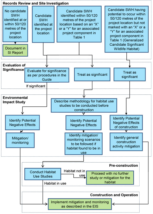
Appendix E: Glossary of terms
- Alvar
- Naturally open areas of thin or no soil over essentially flat limestone, dolostone or marble rock, supporting a sparse vegetation cover of mostly shrubs and herbs.
- Applicant
- means a person who applies for the issuance of a renewable energy approval.
- Area of Natural and Scientific Interest (earth science)
- means an area that has earth science values related to protection, scientific study or education.
- Area of Natural and Scientific Interest (life science)
- means an area that has life science values related to protection, scientific study or education.
- Candidate Significant Wildlife Habitat
- means a potential area of wildlife habitat that may be considered significant using procedures established or accepted by MNR
- Coastal Wetland
- means a wetland that is located,
- on Lake Ontario, Lake Erie, Lake Huron, Lake Superior or Lake St. Clair,
- on the St. Mary’s, St. Clair, Detroit, Niagara or St. Lawrence River, or
- on a tributary to any water body mentioned in (a) or (b) and, either in whole or in part, downstream of a line located two kilometres upstream of the 1:100 year floodline of the water body including wave run-up.
- Confirmed Significant Wildlife Habitat
- means an area of significant wildlife habitat verified using procedures established or accepted by MNR
- Conservation Reserve
- means a conservation reserve within the meaning of the Provincial Parks and Conservation Reserves Act, 2006.
- Earth Science Values
- means values that relate to geological, soil and landform features of the environment.
- Ecological Land Classification (ELC)
- refers to ecological units defined on the basis of bedrock, climate (temperature, precipitation), physiography (soils, slope, aspect) and corresponding vegetation. This classification of the landscape enables planners and ecologists to organize ecological information into logical integrated units to enable landscape planning and monitoring.
- Ecological Function
- means the natural processes, products or services that living and non-living environments provide or perform within or between species, ecosystems and landscapes. These may include biological, physical and socio-economic interactions.
- Environmental Impact Study
- also referred to as an environmental impact assessment, it is a common means of assessing environmental effects.
- Life Science Values
- means values that relate to the living component of the environment.
- Mitigation
- includes the prevention, modification or alleviation of effects on the natural environment, and specifically in the context of natural features, the prevention of negative environmental effects. Also includes any action with the intent to enhance beneficial effects.
- Natural Feature
- means, all or part of,
- an area of natural and scientific interest (earth science),
- an area of natural and scientific interest (life science),
- a coastal wetland,
- a northern wetland,
- a southern wetland,
- a wildlife habitat,
- a woodland,
- a sand barrens, a savannah, a tallgrass prairie and an alvar in the Greenbelt Plan’s Protected Countryside Area, or
- a sand barrens, a savannah and a tallgrass prairie in the Oak Ridges Moraine Plan Area
- Negative Environmental Effect
- means a negative effect that will be caused or that might reasonably be expected to be caused to the environment.
- Northern Wetland
- means a wetland located north of the northern limit of Ecoregions 5E, 6E and 7E as shown in Figure 1 in the Provincial Policy Statement issued under section 3 of the Planning Act and approved by the Lieutenant Governor in Council by Order in Council No.140/2005.
- Project Location
- means, when used in relation to a renewable energy project, a part of land and all or part of any building or structure in, on or over which a person is engaging in or proposes to engage in the project and any air space in which a person is engaging in or proposes to engage in the project.
- Provincial Park
- means a provincial park within the meaning of the Provincial Parks and Conservation Reserves Act, 2006.
- Provincially Significant
- means a natural feature that the Ministry of Natural Resources has identified as provincially significant as the case may be; or that has been confirmed in writing by the Ministry of Natural Resources to have been determined to be provincially significant, as the case may be, using applicable evaluation criteria or procedures established or accepted by the Ministry of Natural Resources, as amended from time to time.
- Qualified Professional
- means a person carrying out studies or evaluations as recommended or required by the REA Regulation who meets any specific requirements (e.g. OWES wetland evaluation training) to carry out the study or evaluation and where appropriate meets professional standards in their particular field and is accredited by a professional association.
- Renewable Energy Generation Facility
- has the same meaning as in the Electricity Act, 1998.
- Renewable Energy Project
- means the construction, installation, use, operation, changing or retiring of a renewable energy generation facility.
- Renewable Energy Testing Project
- means the construction, installation, use, operation, changing or retiring of a renewable energy testing facility.
- Sand Barrens
- Means land (not including land that is being used for agricultural purposes or no longer exhibits tallgrass prairie characteristics) that:
- Has sparse or patchy vegetation that is dominated by plants that are:
- Adapted to severe drought and low nutrient levels; and
- Maintained by severe environmental limitations such as drought, low nutrient levels and periodic disturbances such as fire;
- Has less than 25 per cent tree cover;
- Has sandy soils (other than shorelines) exposed by natural erosion, depositional process or both;
and
- Has been further identified, by the Ministry of Natural Resources or by any other person, according to evaluation procedures established by the Ministry of Natural Resources, as amended from time to time.
- Has sparse or patchy vegetation that is dominated by plants that are:
- Savannah
- Means land (not including land that is being used for agricultural purposes or no longer exhibits savannah characteristics) that:
- Has vegetation with a significant component of non-woody plants, including tallgrass prairie species that are maintained by seasonal drought, periodic disturbances such as fire, or both;
- Has from 25 per cent to 60 per cent tree cover;
- Has mineral soils; and
- Has been further identified, by the Ministry of Natural Resources or by any other person, according to evaluation procedures established by the Ministry of Natural Resources, as amended from time to time.
- Significant
- means a natural feature that the Ministry of Natural Resources has identified as significant as the case may be; or that has been confirmed in writing by the Ministry of Natural Resources to have been determined to be significant, as the case may be, using applicable evaluation criteria or procedures established or accepted by the Ministry of Natural Resources, as amended from time to time.
- Southern Wetland
- means a wetland located south of the northern limit of Ecoregions 5E, 6E and 7E as shown in Figure 1 in the Provincial Policy Statement issued under section 3 of the Planning Act and approved by the Lieutenant Governor in Council by Order in Council No. 140/2005.
- Tallgrass Prairies
- Means land (not including land that is being used for agricultural purposes or no longer exhibits tallgrass prairie characteristics) that:
- Has vegetation dominated by non-woody plants, including tallgrass prairie species that are maintained by seasonal drought, periodic disturbances such as fire, or both
- Has less than 25 per cent tree cover;
- Has mineral soils; and
- Has been further identified, by the Minister of Natural Resources or by any other person, according to evaluation procedures established by the Ministry of Natural Resources, as amended from time to time.
- Wetland
- means land such as a swamp, marsh, bog or fen, other than land that is being used for agricultural purposes and no longer exhibits wetland characteristics, that,
- is seasonally or permanently covered by shallow water or has the water table close to or at the surface, and
- has hydric soils and vegetation dominated by hydrophytic or water-tolerant plants.
- Wildlife Habitat
- means an area where plants, animals and other organisms live or have the potential to live and find adequate amounts of food, water, shelter and space to sustain their population, including an area where a species concentrates at a vulnerable point in its annual or life cycle and an area that is important to a migratory or non-migratory species.
- Woodland
- means a treed area, woodlot or forested area, other than a cultivated fruit or nut orchard or a plantation established for the purpose of producing Christmas trees, that is located south and east of the Canadian Shield as shown in Figure 1 in the Provincial Policy Statement issued under section 3 of the Planning Act and approved by the Lieutenant Governor in Council by Order in Council No. 140/2005
Footnotes
- footnote[1] Back to paragraph For additional information on renewable energy project approvals, visit the Renewable Energy Facilitation Office’s website or contact them at REFO@ontario.ca or 1-877-440-REFO (7336)
- footnote[2] Back to paragraph O.Reg. 359/09
- footnote[3] Back to paragraph For more information on conservation authorities, including maps identifying where conservation authorities are located see Conservation Ontario’s website.
- footnote[4] Back to paragraph For the purposes of the Guide “development” means the construction, ins tallation or expansion of a renewable energy generation facility as part of a renewable energy project at a project location.
- footnote[5] Back to paragraph Access routes or trails for all-terrain vehicles, snowmobiles, and similar conveyances are not considered to be existing trans portation systems for the purposes of the Guide.
- footnote[6] Back to paragraph See Table 3
- footnote[7] Back to paragraph The Municipal Act, 2001 empowers all levels of municipalities (at their discretion) to pas sforest conservation by-laws which regulate tree cutting. Applicants seeking to remove trees will be subject to these by-laws where they exist.
- footnote[8] Back to paragraph For maps of the plan areas see the Ministry of Municipal Affairs and Housing’s Greenbelt Plan Area maps and Oak Ridges Moraine Conservation Plan Area maps
- footnote[9] Back to paragraph Renewable energy projects are generally prohibited within provincial parks or conservation reserves, although some exceptions are listed in Section 19 of the Provincial Parks and Conservation Reserves Act, 2006. Projects meeting the requirements to locate within these areas are subject to a NHA; however, the EIS component is replaced by conditions under the Provincial Parks and Conservation Reserves Act, 2006.
- footnote[10] Back to paragraph Land “south and east of the Canadian Shield” means land lying south and east of southern boundary of the Precambrian Shield excluding Manitoulin Island.
- footnote[11] Back to paragraph For further information on the Environmental Effects Monitoring Plan for birds and bats, applicants should consult the MNR Birds and Bird Habitats; and Bats and Bat Habitats: Guidelines for Wind Power Projects.
- footnote[12] Back to paragraph MNR may also provide the applicant with an addendum to the original confirmation and comments where no further work is required; however, the applicant’s propos ed changes res ult in a reduction in monitoring requirements in the Environmental Effects Monitoring Plan (e.g. infrastructure removed from project design).
- footnote[13] Back to paragraph Projects eligible to follow the pre-2011 REA Regulation are not required to include written comments from
- footnote[14] Back to paragraph For more information on the Approval and Permitting Requirements Document for Renewable Energy Projects see MNR’s renewable energy webpage at http://www.mnr.gov.on.ca/en/Business/Renewable/index.html [link inactive]
- footnote[15] Back to paragraph Permits may also be required to undertake site investigation, evaluation of significance and EIS work (e.g. work permit under the Public Lands Act).
- footnote[16] Back to paragraph Applicants should also consider collecting information regarding the features, functions and values of provincial parks and conservation reserves during records review, as this information will be necessary if the project is proposed within the setback of these protected areas.
- footnote[17] Back to paragraph The availability of records and procedures for processing natural feature information requests may vary across MNR regional and districts offices.
- footnote[18] Back to paragraph The NHIC’s Biodiversity Explorer website provides viewing of generalized information on sensitive data including rare species, plant community occurrences, and natural areas. Applicants seeking more detailed information on sensitive data can contact MNR regional or district offices. In the event that the geographic area of interest pertains to more than one MNR district, the NHIC should be contacted directly.
- footnote[19] Back to paragraph The Significant Wildlife Habitat Technical Guide was produced as a supplement to the 1999 version of the Natural Heritage Reference Manual to support municipal planning, but remains the most relevant technical document for guiding applicants in identifying significant wildlife habitat.
- footnote[20] Back to paragraph MNR preferred coordinate systems: Geographic Coordinate System based on NAD 1983 Datum; Universal Transverse Mercator, zones 15 to 18, based on NAD 1983 Datum.
- footnote[21] Back to paragraph Ortho-rectified aerial photography coverage is available for most of southern Ontario and is superior to non- ortho-rectified images and OBMs.
- footnote[22] Back to paragraph For information on technical guidance for provincial plan areas see: Greenbelt Plan, The Oak Ridges Moraine Conseration Plan, and the Lake Simcoe Protection Plan
- footnote[23] Back to paragraph Functionally-related wetlands should be grouped into complexes and the outer boundaries of each individual wetland unit should be delineated.
- footnote[24] Back to paragraph The ELC definition for “forest” is based on 60% tree crown cover and includes first approximation codes FOD, FOM, FOC, CUP, SWD, SWM and SWC.
- footnote[25] Back to paragraph If undertaking on-ground stem estimates, all meas urements of trees are to be taken at 1.37 metres from the ground. Trees regenerating on formerly non-treed fields should reach this height to be counted. Small trees in an area with some existing cover of larger trees (e.g. savannahs) do not need to reach this height to be counted.
- footnote[26] Back to paragraph MNR can provide applicants with information regarding percentage forest cover of municipalities. For information, contact the local MNR regional or district office (see Appendix B.1.1).
- footnote[] Back to paragraph The Design and Operations Report is a component of the REA Regulation and is reviewed and approved by the MOE. For more information applicants should contact the MOE.
- footnote[28] Back to paragraph The Construction Plan Report is a component of the REA Regulation and is reviewed and approved by the MOE. For more information applicants should contact the MOE.
- footnote[29] Back to paragraph As part of the EIS Report submission, applicants should provide final versions of the environmental effects monitoring plan and construction plan report sections which make reference to natural features. Applicants making changes to these documents after confirmation may be required to re-s ubmit the EIS Report to MNR.
- footnote[30] Back to paragraph The Guide uses the term data layer in a general GIS application sense to describe geospatial information sources. Data custodians may use different terminology with intended technical meaning (e.g., data classes, datasets).
- footnote[31] Back to paragraph This resource can also be used for non-forested areas but is less suitable because it is not as detailed as the southern ELC system.
- footnote[32] Back to paragraph Although the OWES is the official MNR source of information for assessing wetland functions, applicants undertaking the Wetland Characteristics and Ecological Functions Assessment for Renewable Energy Projects may make use of additional resources. For further information regarding approaches to assessment, the Canadian Wildlife Service technical report: Wetland Ecological Functions Assessment: An Overview of Approaches is recommended (Appendix B.1.5).
- footnote[33] Back to paragraph Documenting the use of the particular habitat may involve season specific studies (e.g. habitat assessment, inventories) to determine wildlife species diversity and abundance within the habitat.