North Montreal River Moraine Conservation Reserve Management Statement
This document provides policy direction for the protection, development and management of the North Montreal River Moraine Conservation Reserve and its resources.
Revised January 2005
Prepared by:
Tom Kenerknecht, RPF
Approval statement
We are pleased to approve this Statement of Conservation Interest (SCI) for the North Montreal River Moraine Conservation Reserve (C1526). Direction for the establishment, planning and management of conservation reserves is defined under the Public Lands Act and the Crown Land Use Policy Atlas.
North Montreal River Moraine Conservation Reserve is located approximately 75 km southeast of the town of Wawa. The conservation reserve (CR) has an area of 553 hectares and consists of high ridges and steep south facing slopes. The CR is within the Algoma Forest in the Wawa and Sault Ste. Marie Districts.
The public was invited to comment on the proposed boundary of North Montreal River Moraine CR in November 1999. An opportunity was provided for the public to participate in the preparation of this SCI in January/February of 2001. The public was also invited to comment on the draft SCI in March of 2001. Comments and concerns registered will be reflected in the final Statement of Conservation Interest. A final inspection opportunity will be provided for the public to review this approved SCI document. An interdisciplinary planning team having expertise in forest ecology, biology, land management, and fire management took part in the preparation of this document. A draft was provided to the MNR Regional Planning Unit for review.
This Basic SCI provides guidance for the management of the North Montreal River Moraine Conservation Reserve and provides the basis for the ongoing monitoring of activities. More detailed direction is not anticipated at this time. Should significant facility development be considered or complex issues arise requiring additional studies, more defined management direction, or special protection measures, a more detailed Resource Management Plan will be prepared with full public consultation.
The North Montreal River Moraine Conservation Reserve is managed under the jurisdiction of the District Manager and the Wawa Area Supervisor, Wawa District, Ministry of Natural Resources.
Submitted by:
Plan Author:
Tom Kenerknecht, RPF
Date: Jan/12/05
District Manager Recommendation for Approval
Date: Jan/12/05
Approved by:
Regional Director/Northeast Region
Date: Jan/18/05
1.0 Introduction
The North Montreal River Moraine Conservation Reserve is a 553 hectare site that was regulated as a conservation reserve (CR) on December 21, 2000 (see section 8.0). The site was recommended for conservation reserve status in the Ontario’s Living Legacy Land Use Strategy, approved in July 1999. In late 1999, prior to regulation, consultation on boundary refinement was conducted with Clergue Forest Management Inc. the current Sustainable Forest Licence (SFL) holder, local First Nations, and the general public.
The site is located in the Algoma Section at the northwestern extreme of the Great Lakes/St. Lawrence Forest Region (Rowe, 1972). The conservation reserve is characterized by high east west ridges and steep southern slopes. This precipitous topography provides varied microsites as well as outstanding scenery in the general area. In terms of representation, the site is provincially significant in that it contains at least 5 landform and vegetation combinations dominated by mixed conifer and deciduous stands on ground moraine.
The purpose of this Statement of Conservation Interest (SCI) is to identify area values and provide clear direction on management activity and appropriate land uses. Mining, hydroelectric power development and commercial forestry are prohibited by legislation, and many other activities are guided by the approved Ontario’s Living Legacy Land Use Strategy and the Crown Land Use Policy Atlas (see Appendix 9.2 for details on permitted land and resource uses). Since the site generated little interest during public consultation on boundary refinement, and since higher level planning documents provide direction on most activities in the CR, a more detailed Resource Management Plan is not required.
The North Montreal River Moraine CR helps contribute to the representation of the province’s ecosystems and natural features. The addition of the protected areas recommended by Ontario’s Living Legacy will help complete the Provincial Parks system within the planning area and protect 12% of its land and water base.
2.0 Goals
2.1 Goals of Conservation Reserves
The Goal of Conservation Reserves is to protect natural heritage values on public lands while permitting compatible land use activities.
2.1.1 Short term goals
- To identify the state of the resource with respect to natural heritage values and current land use activities for the conservation reserve
- To manage the conservation reserve to protect the integrity of its natural values via specific guidelines, strategies, and prescriptions detailed in this plan
2.1.2 Long term goals
- To establish representation targets (e.g. future forest conditions) and evaluate the site as a potential scientific benchmark
- To address future new uses and activities
- To identify research and marketing strategies and client services.
3.0 Management planning
3.1 Planning context
3.1.1 Planning area
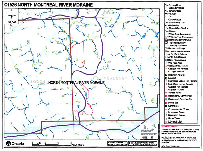
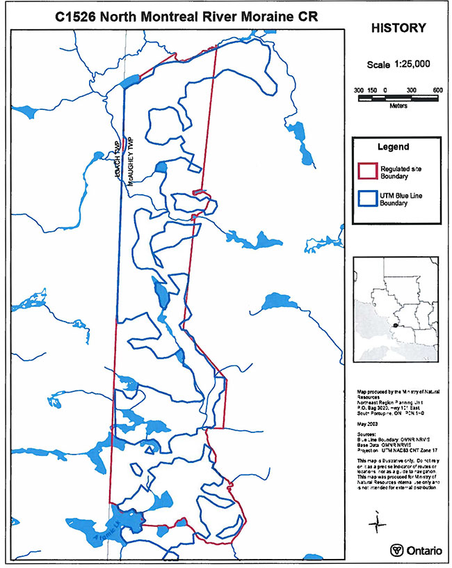
Conservation reserves are established by regulation under the Public Lands Act. North Montreal River Moraine Conservation Reserve was regulated as a conservation reserve under authority of the Public Lands Act (O. Reg. 805/94) on December 21, 2000. The planning area for this SCI is the regulated boundary of the conservation reserve (there are no Forest Reserves associated with this CR) (Map 8.3).
For purposes of Resource Management Planning and for other land uses, particularly for Forest Management Planning, the boundary of the conservation reserve in itself will not be treated as a ‘value’. Management Prescriptions presented in this plan will relate to the activities within the conservation reserve, will identify the location, shape, size, significance and sensitivity of natural heritage values, and will identify additional special features within the boundary of the site. Management actions outside the boundary of the conservation reserve will continue to consider the site’s natural heritage features, recreational values and protection requirements within larger landscape plans such as Forest Management Plans.
3.1.2 Management planning context
The North Montreal River Moraine Conservation Reserve and its associated permitted uses receive direction from the Ontario’s Living Legacy Land Use Strategy (MNR 1999), the Crown Land Use Policy Atlas) and all other subsequent planning direction developed under this plan. The conservation reserve has been withdrawn from the Algoma Forest Sustainable Forestry Licence (SFL), and commercial forestry will no longer occur within its regulated boundaries. Since there has been no recent timber harvesting, post harvest silvicultural activities will not be required as a non-conforming use.
Fish and Wildlife management activities will generally occur in much the same fashion as in surrounding crown lands.
There are no mining claims or leases in the Conservation Reserve.
There is currently no land in the CR under land tenure. In the future, land in the conservation reserve will not be sold or leased. New uses and potential commercial activities may be acceptable if they do not impact the natural heritage values of the site. Such activities will be considered on a case-by-case basis and must pass a test of compatibility to be accepted (MNR, 1997). Authorization for potential compatible uses will be in the form of a Land Use Permit or Licence of Occupation.
Fire Management is described in Section 6.3
Specific land and resource use is described in Section 5.
3.2 Planning process
The planning process for the North Montreal River Moraine CR involves 3 public consultation phases. In January 2001, newspaper notices appeared in the Wawa and Sault Ste. Marie newspapers advising that planning for the CR was being initiated, and inviting the public and interested organizations to supply background information and viewpoints. At approximately the same time, there was a direct mail out to the public and organizations known to be interested in, or affected by the conservation reserve.
The draft SCI was forwarded to anyone who participated in the process to date. As well, notices in the Wawa and Sault Ste. Marie newspapers invited any interested person to request a copy of the draft Statement of Conservation Interest. The notice also stated that only those who have participated in the planning process will be notified of plan approval.
The final public consultation phase will be an inspection of the MNR-approved SCI during which participants in the planning process will be able to request copies of the plan to see how their comments were addressed. After this public inspection, the plan will be implemented.
Notices will not be placed on the Environmental Registry since this SCI is not considered a policy under the Environmental Bill of Rights.
4.0 Background information
4.1 Location and site description
4.1.1 Location
The North Montreal River Moraine CR is located along the western boundary of McAughey Township, in the Ministry of Natural Resources’ Wawa District. It is within the Territorial District of Algoma, about 90 km northeast of Sault Ste. Marie and 75 km southeast of Wawa. The southern boundary of the CR is approximately 700 meters north of the Montreal River.
4.1.2 Physical description
The North Montreal River Moraine is at the northern extremity of Hill’s Site District 4E-2. It is also within the Algoma Section of the Great Lakes/St Lawrence Forest Region (Rowe, 1972).
The Algoma Section is at the northwestern extremity of the Great Lakes Forest Region, and has a frost-free period of only 100 days, and only 1333 growing degree-days. Mean January temperatures are in the range of -10 to -100 °C.
The proximity to Lake Superior may have a moderating effect on temperatures, and may result in increased snowfall. However, the extent of Lake Superior’s effect is not known since there are no weather stations near the site.
The rugged topography of the area has a significant effect on microclimate, and in turn species composition. Sugar maple and yellow birch are by far the most common species in the CR, especially on south facing slopes. A scattering of boreal forest species such as white birch and balsam fir tend to occupy north slopes and lower elevations, especially frost pockets. A stand of poplar, white birch and black spruce exists at the northwest comer of the site. White pine, some of them resulting from fires in the early 1880’s, are a minor component of some stands, and cedar exists in low areas near lakes and streams. Largely because of the thin soils, many stands are under stocked and site classes tend to be low. In the early 1980’s a severe spruce budworm epidemic caused widespread mortality among balsam fir and white spruce in the CR and surrounding areas.
According to the Forest Land Productivity System (FLAPS), the conservation reserve is overlapped by two major geomorphologic deposits. The north and west areas of the reserve are characterized by about 70% rock outcrop and 30% till deposit coverage. The south and east areas of the reserve are characterized by 60% till deposits, 30% compacted till deposits, and 10% rock outcrop.
According to Northern Ontario Engineering Geology Terrain Study (NOEGTS), the majority of the conservation reserve is found on Rock Knob terrain. A small portion of the northwest comer of the reserve is found on Alluvial Plain, and a minimal portion of the northeast comer is found on Organic Terrain (McQuay, 1979).
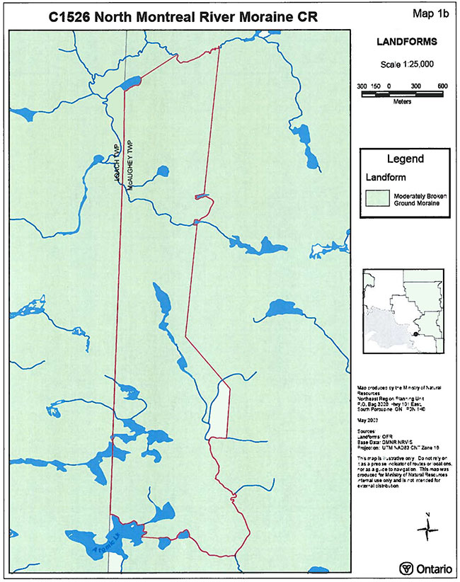
Map 8.4 shows the landform geology of the conservation reserve consists of moderately broken ground moraine. Soils in the area vary greatly in depth, with thinly soiled hills and deeper deposits in valleys. Almost all soils have formed on unconsolidated parent materials transported from non-local sources by glacial action and subsequent meltwater drainage. Soil moisture content is directly related to topography, with dry sites on hills and wetter soils in lower areas. The most notable glacicofluvial features are the extensive ground moraine deposits. Bedrock geology is precambrian, typical of the Canadian Shield.
The Gartshore Reservoir of the Montreal River is about 700 meters to the south of the CR. The rugged topography in the area results in spectacular scenery, especially in the autumn when fall colours peak. The Montreal River, 700 meters south of the reserve, offers an excellent vantage point for viewing.
4.2 Administrative description
Map 8.3 shows the regulated boundary of the conservation reserve. The CR is entirely within the Wawa Forest, held under a Sustainable Forestry Licence by Clergue Forest Management Inc.
4.3 History of the site
The North Montreal River Moraine CR is and has been fairly remote. Without road access to the site, there has been limited logging. Some cutting occurred along the Montreal River in the early 1900’s, but records do not indicate how far from the river the logging extended. In more recent times, there was partial cutting for mainly white pine in the 1980’s, but this was confined to the area near the river, southeast of the conservation reserve. Wood was transported along the river making it the last river drive that occurred in Ontario.
A total of four hydroelectric generating stations are present on the Montreal River. Hydro development first occurred in 1937 at Montreal Falls. Subsequent development occurred at Andrews (1938), Gartshore (1958) and Hogg (1965) stations. The conservation reserve is located just north of the Gartshore Reservoir.
A relatively large fire occurred in the vicinity of the conservation reserve in 1948. The fire was about 13,000 hectares in size and impacted the northern half of the conservation reserve and surrounding areas.
No additional historical or current non-tenure land use for the site is known.
4.4 Inventories
Table 2 illustrates the inventories/surveys completed for North Montreal River Moraine CR, as well as any future requirements for earth and life sciences, cultural, recreational or other categories. The detailed Life (Burhardt, 2003), and Earth Science Planning Summary (Kristjansson) and sections 4.1 and section 5.0 describe the key features of the CR.
Table 2: Inventory and survey information for Manitou Mountain Conservation Reserve
| Survey Level Reconnaissance |
Earth Science | Life Science | Cultural | Recreational |
|---|---|---|---|---|
| N/A | Kristjansson, F.J. Earth Science Planning Summary North Montreal River Moraine (C1526) | Burkhardt, B. et al. 2003 North Montreal River Moraine Conservation Reserve (C1526) Life Science Checksheet - Step 2 | None | East, S., 2004, North Montreal River Moraine Conservation Reserve (C1526) Recreation Resource Inventory Report. |
| Detailed | None | None | None | None |
| Requirement | Final Earth Science Checksheet | Comparison with current provincial landform layers to determine site significance. | None | Recommend monitoring |
Future detailed surveys may be conducted as required to assist in the day-to-day management of the conservation reserve or to contribute to a larger provincial inventory, monitoring and assessment reporting (IMAR) program for the parks and protected areas system. More detailed surveys will follow appropriate standards and guidelines to ensure the quality of the data collected (e.g. Forest Ecosystem Classification (FEC) Field Guides, Ontario Wetlands Evaluation System, Growth and Yield, Wildlife Assessment methods etc.).
5.0 State of the Resource
The main representation feature of the conservation reserve is the extensive ground moraine. With little activity in the past, and with the area’s status as a protected area, there is little threat to the integrity of the moraine. Similarly, the absence of clear-cut logging in the past, and the area’s protected status has and will allow stand development to proceed without the perturbation of timber harvesting.
On the other hand, fire suppression could affect natural processes. The area’s location in the northern section of the Great Lakes Forest Region makes it difficult to assess how large a role wildfire has played. The preponderance of low flammability tolerant hardwood species would suggest resistance to fire, and stand replacement fires would presumably be rare. However, low intensity surface fires could be fairly common.
The lack of free carbonates in the conservation reserve’s soils results in low buffering capacity to acidic precipitation. Increased acidity in tum affects the availability of some nutrients to plants.
The relatively good species diversity of the site including a good number of vegetation cover types and a high degree of evenness (i.e. no one single cover type dominates) of that diversity are significant features of the site. Some natural disturbances such as windthrow, ice damage, beaver activity and infestations of insects and disease could affect the current diversity, but these natural processes will not be interfered with. Currently, no mining tenure in the form of claims, leases or patent lands occurs within the conservation reserve and there are no mining lands located adjacent to the site or any known past mining activity within the conservation reserve.
5.1 Socio/economic interest in area
The Montreal River area is currently used by local First Nations for hunting, but its distance from existing First Nation communities limits its use. Native Values mapping in the Forest Management Planning process has not identified any specific values in or adjacent to the conservation reserve.
It is difficult to assess pre-Columbian use of the river, but its rapids and waterfalls, and its distance from other major rivers probably affected its use as a major transportation route.
Sporadic timber harvesting has occurred near the site (logging along river in early 1900’s; partial cut logging southeast of the conservation reserve in the 1980’s) but the remoteness of the site has lessened its importance to commercial forestry.
The area is ranked as medium to high mineral potential in the Wawa District Land Use Guidelines Background Information, but there are no staked mining claims within the conservation reserve. Mining and surface rights have been withdrawn from staking within the conservation reserve boundaries under the Mining Act (RSO 1990 Chapter M.l4)
The North Montreal River Moraine CR is currently protected within an Intensive Fire Zone in which the social objectives are to prevent injury, loss of life, and social disruption resulting from forest fire, and to minimize the negative impact of fire on public works, private property, and the natural resources of Ontario.
5.2 Natural heritage stewardship
The current condition of the conservation reserve’s vegetation shows spruce budworm damage, particularly from an infestation in the early 1980’s. There are no records of forest fires occurring on the site since 1948. Forest fire protection is currently carried out as on surrounding public lands and no strategies have been put in place to utilize the natural benefits of fire in achieving vegetation management within the conservation reserve. No catastrophic floods, erosion, rockslides, ice storms, or windthrow are known to have occurred within the site.
Generally, the Ontario Living Legacy Land Use Strategy established the intent to add new conservation reserves to the existing network of conservation reserves to complement provincial parks in protecting representative natural areas and special landscapes.
There are no existing monitoring programs or research plots in the conservation reserve.
5.3 Fisheries and wildlife
The conservation reserve is located in a relatively remote and operationally difficult area of the Algoma Forest. The area has not had a complete values inventory performed in terms of identifying thermal regimes of lakes, presence of critical fish habitat, moose aquatic feeding areas, moose late wintering areas, stick nests or other values information typically associated with Forest Management Planning. Information on fisheries resources, natural springs, and water quality is not available.
Hunting and fishing will continue to be permitted on the site, and fish and wildlife management will continue on the site in much the same fashion as before its regulation as a conservation reserve.
Preliminary assessment for the potential of the site to contribute to the protection of one or more species at risk (SAR) will depend on regional SAR initiatives to determine SAR criteria that could be achieved in part or completely by the site. If the conservation reserve could play a role within the SAR program, then possibly more intensive on-the-ground surveys would have to be conducted. The site’s border line locations that include the northern portion of the Great Lakes/St. Lawrence Forest Region, the southern boundary of Crins and Uhlig’s (2000) 4E-1 Site District and its association with Lake Superior and the Montreal River may increase the site’s chances of containing SAR species. In addition, the site’s high diversity and well distributed cover types, varied topography and excellent condition would also contribute to the site’s potential as a candidate for a number of rare, vulnerable or threatened species. However, the site’s lack of physical connection with the Montreal River and its small size may also reduce potential for high diversity and presence of SAR species or habitat.
5.4 Cultural heritage stewardship
Historically, this region of Ontario was used by local First Nations since before written records exist, and their descendants currently use the area for hunting. However, the conservation reserve’s remoteness limits its use. No known Aboriginal or Non-Aboriginal values have currently been identified for the site. Given the remoteness of the site, and the lack of evidence of specific prehistoric use, it is anticipated that the site has not contributed significantly to the region’s local cultural heritage.
The elimination of most potential industrial activities should protect any cultural values in the site. A site specific cultural survey is not recommended at this time, but if a provincial scan is conducted it may identify the need for a site specific survey.
5.5 Land use/existing development
As described in previous sections, past land use has been low, and there are no known existing developments on site.
The western boundary of the site is Loach Township, which is under private ownership.
5.6 Commercial use
No trapping, bait fishing or commercial bear hunting presently occurs on the site. No wild rice production occurs in the conservation reserve. No other commercial use is known to occur in the conservation reserve.
5.7 Tourism/recreation use/opportunities
At present, there are no tourism or recreational facilities in the CR. Lack of road access or lakes large enough for landing by fixed wing aircraft, and the fact that motorboat launching areas on the Gartshore Reservoir are not accessible to the general public are severe limitations on commercial tourism.
Recreational use faces the same challenges as commercial tourism. The Montreal River is not a designated canoe route, and canoeing and kayaking are affected by difficulty in accessing launch points on the river. The site is rarely, if ever, accessed by snowmobile.
5.8 Client services
The North Montreal River Moraine Conservation Reserve is not likely to see developments such as recreational facilities and interpretive centres. However, the site may lend itself to ecological research, and the MNR will cooperate with agencies wishing to conduct non-consumptive research. If development or research proposals arise they will be required to undergo a Test of Compatibility (Appendix 9.1).
6.0 Management planning strategies
Implementation of this SCI will achieve the goals outlined in section 2.1. The site will be protected by the prohibition of industrial activities. Future inventories will determine the site’s value as a scientific benchmark and indicator of ecosystem health.
Anticipated uses and their potential impacts on the ecological integrity of the site have been addressed in this plan, in the Ontario’s Living Legacy Land Use Strategy, and in the MNR’s Conservation Reserves Policies and policy interpretations. In the event that unanticipated activities are proposed, they will be evaluated by the Test of Compatibility (Appendix 9.1) outlined in Policy PL 3.03.05.
6.1 State of the resource management strategies
Various activities have been discussed in previous sections, and the following section briefly summarizes how the site fits into broader perspectives. Strategies to manage specific features are described in Sections 6.2 and 6.3.
The CR contributes to Natural Heritage Stewardship through its contribution to ecosystem representation, and Provincial Parks targets. The main feature of the site, the ground moraine, is not sensitive to non-industrial activities and will remain intact. The other main feature of the site, the mixed wood forest, is protected from logging but not from fire suppression. However, unlike the protected areas in the boreal forest portions of Wawa District, this Great Lakes/St. Lawrence forest type is not as dependent on fire to maintain its diversity and productivity. Fire management is discussed further in Section 6.3.
There are no natural heritage values on the site that are known to require specific protection, management or restoration. The surveys discussed in Section 5.3 may identify sensitive fish and wildlife values. It can be expected that many of these new values will be protected by the prohibition of industrial activities but if necessary, restrictions on other uses may be necessary. For example, snowmobile or ATV trails may not be compatible with noise sensitive species and route relocation or timing restrictions may be necessary.
The conservation reserve will be managed under a passive approach in which vegetation will be allowed to develop naturally. Thus, there is not a desired future forest condition.
Native use of the site for traditional purposes and the exercise of aboriginal and treaty rights will continue.
The site has been excluded from the Algoma Forest, but the loss of land base to Clergue Forest Management is within the context of Ontario’s Living Legacy, the OLL Forest Accord, and the Living Legacy Trust, all of which support the long term continuity and security of wood supply.
The area may not be heavily used for tourism purposes in the foreseeable future but the North Montreal River Moraine CR, and the abundance of protected areas in the Algoma region will contribute to tourism marketing by local communities.
6.2 Specific features and management strategies
Possibly the greatest human intervention that the site will undergo (except for global problems such as carbon dioxide enrichment of the atmosphere) is fire suppression. The site is not particularly sensitive to intense crown fires due to a preponderance of tolerant hardwoods of relatively low flammability and confinement of conifers to mainly lowland areas. On the other hand, surface fires in the Algoma area are relatively common, and have an ecological role in creating seedbed (especially for species unable to penetrate thick layers of maple leaves) and reducing fuel layers.
The following principles will be considered in future fire management planning in the Reserve:
- Management of a natural fire may occur under specific circumstances where fiscal management and ecological benefits are balanced and weather indices are If these conditions are not met, then the fire will be suppressed. An example of when natural fire could be managed would be in mid to late autumn with no drought and when fire suppression resources are adequate to control the fire.
- Prescribed burning will be acceptable since under the right conditions, it will replicate a moderate surface fire. In particular, prescribed burning will be encouraged if it provides research opportunities, or if its purpose is to compensate for a fire whereby suppression was necessary. The area has some natural boundaries in the southern section that would help to contain a prescribed burn.
- When fire suppression activities are required in the CR, “light on the land” techniques will be used.
There are no bait fish licences or traplines issued for the site, and the area is within a Bear Management Area Reserve (not currently licensed). Trapline areas, bait fish areas, and bear management areas may be licensed for the site (dependant on the results of a Test of Compatibility) since they are not likely to jeopardize the ground moraine and mixed wood forest for which the site was protected.
Loach Township, adjacent to the western boundary of the CR is privately owned. If patent lands become available near the western boundary, opportunities to expand the CR and increase representation will be considered.
6.3 Inventory, monitoring, and assessment reporting
The conservation reserve, being largely free from human impact, has potential as an ecological benchmark or baseline against which the surrounding, managed forest can be compared. However, no ecological research is planned at this time.
6.4 Implementation and plan review strategies
This SCI does not prescribe any active management of the site. Curtailment of industrial activities will fulfill the goal of protecting natural heritage values and the integrity of the site.
The SCI will not have a formal review or expiry date. Monitoring of the CR will occur on an ongoing basis, and the plan will be revised if and when additional management strategies are required. For example, if use of the site for commercial purposes was proposed, the SCI would be revised to address the compatibility of the proposed use.
6.5 Marketing strategies
There are no plans to actively promote the area for research, or for commercial purposes such as tourism.
7.0 References
Burkhardt, B. et al., 2003. North Montreal River Moraine Conservation Reserve (C1526) Life Science Checksheet - Step 2.
Crins, W.J. and P.W.C. Uhlig, 2000. Ecoregions of Ontario: Modifications to Angus Hills Site Regions and Site Districts - Revisions and Rationale.
Kristjansson, F.J. Undated. Earth Science Planning Summary, North Montreal River Moraine (C1526).
McQuay, D.F., 1979. Northern Ontario Engineering Geology Terrain Study, Data Base Map, Batchawana; Ontario Geological Survey, Map 5011, Scale 1:100,000
Ministry of Natural Resources (MNR), 1997. MNR Prescribed Burn Planning Manual.
Rowe, J.S., 1972. Forest Regions of Canada.
8.0 Maps
8.1 Recreation inventory map
Enlarge 8.1 Recreation inventory map
8.2 Site location map
8.3 Boundary map
8.4 Landforms map
9.0 Appendices
9.1 Procedural Guideline B - Land Uses - Test of Compatibility
(PL Procedure 3.03.05)
The Conservation Reserve policy provides broad direction with regard to the permitted uses. The policy provides only an indication of the variety of uses that will be considered acceptable in conservation reserves. The only caution is that “any new uses, and commercial activities associated with them, will be considered on a case by case basis, and, they must pass a test of compatibility to be acceptable.”
What does a ‘test of compatibility’ mean?
An examination of this must start from the premise of why an area is set aside - specifically, its representative natural heritage values. Criteria are then identified to guide compatibility considerations. These criteria apply to the long-term acceptability of both existing uses and new uses.
The first ‘test’ is: “do proposed new land uses and/or commercial activities conform to the direction of the SCI/RMP for the conservation reserve? Would the new use(s) depart from the spirit of appropriate indicator land uses in the SCI/RMP?”
- Conformity to SCI/RMP: SCI describe values for which an area has been set aside and the range of appropriate uses that will be permitted in the SCI may also speak to the acceptability of other ‘new’ uses currently not occurring in the area.
- Impact Assessment: If the proposed use(s) pass test 1 it is important to determine their impact on the area before they are approved. This should include the following:
- Impact on natural heritage values: “will the new use(s) impact historical or archaeological values in the area?”
- Impact on research activities: “will the new use(s) affect research activities in the area?”
- Impact on current uses: “will the new use(s) have any negative impact on the array of current uses?”
- Impact on area administration: “will the new use(s) increase administrative costs and/or complexity?” (For example, the cost of area monitoring, security and enforcement.)
- Impact on accommodating the use outside the conservation reserve: “could the use(s) be accommodated as well or better outside the conservation reserve?”
- Impact on socio-economics of the area: “will the new use(s) affect the community(ies) surrounding the area in a positive or negative way?” (For example, will the new use make an area less remote thereby affecting a local tourism industry that is dependent on the area’s remoteness for its appeal?)
- Impact on area accessibility: “does the new use(s) give someone exclusive rights to the area or a portion of the area to the exclusion of other existing uses?”
9.2 Summary of permitted land and resource uses
| Use | Permitted: New | Permitted: Existing |
|---|---|---|
| Commercial timber harvest, commercial hydro development | No | No |
| Mineral exploration and mining | No | No |
| Bait fishing | Maybe | Yes |
| Commercial fur harvesting | Maybe | Yes |
| Sport hunting | Yes | Yes |
| Sport fishing | Yes | Yes |
| Seasonal recreation camps | No | Yes |
| Commercial bear hunting | No | No |
| Tourism Facilities (for resource based tourism) and recreational trails | Maybe | Yes |
| Land Disposition | No | Yes |
| Roads | No | Yes |
| Energy Transmission and Communications Corridors | No | Yes |
| Commercial Food Harvesting | No | No |
| ATV and Snowmobile use on trails | Maybe | Yes |