Red-headed Woodpecker recovery strategy
Read the recovery strategy for Red-headed Woodpecker, a bird at risk in Ontario.
About the Ontario recovery strategy series
This series presents the collection of recovery strategies that are prepared or adopted as advice to the Province of Ontario on the recommended approach to recover species at risk. The Province ensures the preparation of recovery strategies to meet its commitments to recover species at risk under the Endangered Species Act, 2007 (ESA) and the Accord for the Protection of Species at Risk in Canada .
What is recovery?
Recovery of species at risk is the process by which the decline of an endangered, threatened, or extirpated species is arrested or reversed, and threats are removed or reduced to improve the likelihood of a species’ persistence in the wild.
What is a recovery strategy?
Under the ESA a recovery strategy provides the best available scientific knowledge on what is required to achieve recovery of a species. A recovery strategy outlines the habitat needs and the threats to the survival and recovery of the species. It also makes recommendations on the objectives for protection and recovery, the approaches to achieve those objectives, and the area that should be considered in the development of a habitat regulation. Sections 11 to 15 of the ESA outline the required content and timelines for developing recovery strategies published in this series.
Recovery strategies are required to be prepared for endangered and threatened species within one or two years respectively of the species being added to the Species at Risk in Ontario list. Recovery strategies are required to be prepared for extirpated species only if reintroduction is considered feasible.
What’s next?
Nine months after the completion of a recovery strategy a government response statement will be published which summarizes the actions that the Government of Ontario intends to take in response to the strategy. The implementation of recovery strategies depends on the continued cooperation and actions of government agencies, individuals, communities, land users, and conservationists.
For more information
To learn more about species at risk recovery in Ontario, please visit the Ministry of the Environment, Conservation and Parks Species at Risk webpage
Recommended citation
Ministry of the Environment, Conservation and Parks. 2022. Recovery Strategy for the Red-headed Woodpecker (Melanerpes erythrocephalus) in Ontario. Ontario Recovery Strategy Series. Prepared by the Ministry of the Environment, Conservation and Parks, Peterborough, Ontario. iv + 5 pp. + Appendix. Adoption of the Recovery Strategy for Red-headed Woodpecker (Melanerpes erythrocephalus) in Canada (Environment Canada 2021).
Cover illustration: Darren Smith
© King’s Printer for Ontario, 2022
ISBN 978-1-4868-6203-0 (HTML)
ISBN 978-1-4868-6204-7 (PDF)
Content (excluding illustrations) may be used without permission with appropriate credit to the source, except where use of an image or other item is prohibited in the content use statement of the adopted federal recovery strategy.
Cette publication hautement spécialisée « Recovery strategies prepared under the Endangered Species Act, 2007 », n’est disponible qu’en anglais en vertu du Règlement 411/97 qui en exempte l’application de la Loi sur les services en français. Pour obtenir de l’aide en français, veuillez communiquer avec recovery.planning@ontario.ca.
Declaration
The recovery strategy for the Red-headed Woodpecker (Melanerpes erythrocephalus) was developed in accordance with the requirements of the Endangered Species Act, 2007 (ESA). This recovery strategy has been prepared as advice to the Government of Ontario, other responsible jurisdictions and the many different constituencies that may be involved in recovering the species.
The recovery strategy does not necessarily represent the views of all individuals who provided advice or contributed to its preparation, or the official positions of the organizations with which the individuals are associated.
The recommended goals, objectives and recovery approaches identified in the strategy are based on the best available knowledge and are subject to revision as new information becomes available. Implementation of this strategy is subject to appropriations, priorities and budgetary constraints of the participating jurisdictions and organizations.
Success in the recovery of this species depends on the commitment and cooperation of many different constituencies that will be involved in implementing the directions set out in this strategy.
Responsible jurisdictions
Ministry of the Environment, Conservation and Parks
Environment and Climate Change Canada – Canadian Wildlife Service, Ontario
Parks Canada Agency
Executive summary
The Endangered Species Act, 2007 (ESA) requires the Minister of the Environment, Conservation and Parks to ensure recovery strategies are prepared for all species listed as endangered or threatened on the Species at Risk in Ontario (SARO) List. Under the ESA, a recovery strategy may incorporate all or part of an existing plan that relates to the species.
The Red-headed Woodpecker (Melanerpes erythrocephalus is listed as Endangered on the SARO List. The species is listed as Endangered under the federal Species at Risk Act (SARA). Environment and Climate Change Canada prepared the Recovery Strategy for the Red-headed Woodpecker (Melanerpes erythrocephalus) in Canada in 2021 to meet its requirements under the SARA. This recovery strategy is hereby adopted under the ESA. With the additions indicated below, the enclosed strategy meets all of the content requirements outlined in the ESA.
In addition to the habitat needs outlined in the federal recovery strategy, Nickley and Bulluck (2019) suggest that overwintering Red-headed Woodpeckers may benefit from different disturbance regimes across a landscape, as a patchwork of disturbed and undisturbed areas provides more consistent food and habitat resources for the species during the winter.
The Critical Habitat section of the federal recovery strategy provides a partial identification of critical habitat (as defined under the SARA). Identification of critical habitat is not a component of a recovery strategy prepared under the ESA. However, it is recommended that the approach used to identify critical habitat in the federal recovery strategy, along with any new scientific information pertaining to the Red-headed Woodpecker and the areas it occupies, be considered if a habitat regulation is developed under the ESA.
1.0 Adoption of federal recovery strategy
The Endangered Species Act, 2007 (ESA) requires the Minister of the Environment, Conservation and Parks to ensure recovery strategies are prepared for all species listed as endangered or threatened on the Species at Risk in Ontario (SARO) List. Under the ESA, a recovery strategy may incorporate all or part of an existing plan that relates to the species.
The Red-headed Woodpecker (Melanerpes erythrocephalus) is listed as Endangered on the SARO List. The species is listed as Endangered under the federal Species at Risk Act (SARA). Environment and Climate Change Canada prepared the Recovery Strategy for the Red-headed Woodpecker (Melanerpes erythrocephalus) in Canada in 2021 to meet its requirements under the SARA. This recovery strategy is hereby adopted under the ESA. With the additions indicated below, the enclosed strategy meets all of the content requirements outlined in the ESA
1.1 Species assessment and classification
The following list is assessment and classification information for the Red-headed Woodpecker (Melanerpes erythrocephalus). Note: The glossary provides definitions for the abbreviations and technical terms in this document.
- SARO List Classification: Endangered
- SARO List History: Endangered (2022), Special Concern (2008, 2004)
- COSEWIC Assessment History: Endangered (2018), Threatened (2007), Special Concern (1996)
- SARA Schedule 1: Endangered
- Conservation Status Rankings: G-rank: G5; N-rank: N4B,N3M; S-rank: S4B
1.2 Habitat needs
In addition to the habitat needs described in the federal recovery strategy, overwintering Red-headed Woodpeckers may also benefit from a variety of landscape-scale disturbance regimes, as suggested by Nickley and Bulluck (2019). This is because landscapes containing a patchwork of disturbed and undisturbed areas can better maintain Red-headed Woodpecker habitat and food sources during the winter. For example, disturbances such as fires can create snags
1.3 Recommended approaches to recovery
New information under the section on habitat needs above is not discussed in the federal recovery strategy and recovery actions do not fully address this management approach. As suggested in Nickley and Bulluck (2019), implementing habitat management activities across a landscape to maintain a patchwork of disturbed and undisturbed areas should be considered for overwintering Red-headed Woodpeckers, where feasible, when developing recovery initiatives for this species in Ontario.
1.4 Area for consideration in developing a habitat regulation
Under the ESA, a recovery strategy must include a recommendation to the Minister of the Environment, Conservation and Parks on the area that should be considered in developing a habitat regulation. A habitat regulation is a legal instrument that prescribes an area that will be protected as the habitat of the species. The recommendation provided below will be one of many sources considered by the Minister, including information that may become newly available following completion of the recovery strategy should a habitat regulation be developed for this species.
The Critical Habitat section of the federal recovery strategy provides a partial identification of critical habitat (as defined under the SARA). Identification of critical habitat is not a component of a recovery strategy prepared under the ESA. However, it is recommended that the approach used to identify critical habitat in the federal recovery strategy along with any new scientific information pertaining to the Red-headed Woodpecker and the areas it occupies, be considered if a habitat regulation is developed for the species under the ESA.
Glossary
- Committee on the Status of Endangered Wildlife in Canada (COSEWIC):
- The committee established under section 14 of the Species at Risk Act that is responsible for assessing and classifying species at risk in Canada.
- Committee on the Status of Species at Risk in Ontario (COSSARO):
- The committee established under section 3 of the Endangered Species Act, 2007 that is responsible for assessing and classifying species at risk in Ontario.
- Conservation status rank:
- A rank assigned to a species or ecological community that primarily conveys the degree of rarity of the species or community at the global (G), national (N) or subnational (S) level. These ranks, termed G-rank, N-rank and S-rank, are not legal designations. Ranks are determined by NatureServe (NatureServe 2021) and, in the case of Ontario’s S-rank, by Ontario’s Natural Heritage Information Centre. The conservation status of a species or ecosystem is designated by a number from 1 to 5, preceded by the letter G, N or S reflecting the appropriate geographic scale of the assessment. In some cases, taxa are also assigned Breeding Status Qualifiers (letters B, N or M) following their conservation status rank. The numbers and letters mean the following:
1 = critically imperilled
2 = imperilled
3 = vulnerable
4 = apparently secure
5 = secure
NR = not yet ranked
B = breeding—Conservation status refers to the breeding population of the species in the nation or state/province.
N = non-breeding—Conservation status refers to the non-breeding population of the species in the nation or state/province.
M = migrant—Migrant species occurring regularly on migration at particular staging areas or concentration spots where the species might warrant conservation attention. Conservation status refers to the aggregating transient population of the species in the nation or state/province. - Endangered Species Act, 2007 (ESA):
- The provincial legislation that provides protection to species at risk in Ontario.
- Species at Risk Act (SARA):
- The federal legislation that provides protection to species at risk in Canada. This Act establishes Schedule 1 as the legal list of wildlife species at risk. Schedules 2 and 3 contain lists of species that at the time the Act came into force needed to be reassessed. After species on Schedule 2 and 3 are reassessed and found to be at risk, they undergo the SARA listing process to be included in Schedule 1.
- Species at Risk in Ontario (SARO) List:
- The regulation made under section 7 of the Endangered Species Act, 2007 that provides the official status classification of species at risk in Ontario. This list was first published in 2004 as a policy and became a regulation in 2008.
List of abbreviations
- COSEWIC:
- Committee on the Status of Endangered Wildlife in Canada
- COSSARO:
- Committee on the Status of Species at Risk in Ontario
- ESA:
- Ontario’s Endangered Species Act, 2007
- ISBN:
- International Standard Book Number
- MECP:
- Ministry of the Environment, Conservation and Parks
- SARA:
- Canada’s Species at Risk Act
- SARO List:
- Species at Risk in Ontario List
References
NatureServe. 2021. NatureServe Explorer [web application]. Statuses. NatureServe, Arlington, Virginia. Available. (Accessed: August 30, 2021).
Nickley, B., & Bulluck, L. P. 2019. Red-headed Woodpecker (Melanerpes erythrocephalus) winter roost-site selection in a burned forest stand. The Wilson Journal of Ornithology, 131(4), 774-788. (Accessed: October 22, 2021)
Appendix 1. Recovery strategy for the Red-headed Woodpecker (Melanerpes erythrocephalus) in Canada
Official title: Recovery Strategy for the Red-headed Woodpecker (Melanerpes erythrocephalus) in Canada
Species at Risk Act
Recovery strategy series

Document Information
Environment and Climate Change Canada. 2021. Recovery Strategy for the Red headed Woodpecker (Melanerpes erythrocephalus in Canada. Species at Risk Act Recovery Strategy Series. Environment and Climate Change Canada, Ottawa. viii + 118 pp.
For copies of the recovery strategy, or for additional information on species at risk, including the Committee on the Status of Endangered Wildlife in Canada (COSEWIC) Status Reports, residence descriptions, action plans, and other related recovery documents, please visit the Species at Risk (SAR) Public Registry.
Cover illustration: Yousif Attia
Également disponible en français sous le titre
« Programme de rétablissement du Pic à tête rouge (Melanerpes erythrocephalus) au Canada »
© Her Majesty the Queen in Right of Canada, represented by the Minister of Environment and Climate Change, 2021. All rights reserved.
ISBN 978-0-660-37078-1
Catalogue no. En3-4/335-2021E-PDF
Content (excluding the illustrations) may be used without permission, with appropriate credit to the source.
Preface
The federal, provincial, and territorial government signatories under the Accord for the Protection of Species at Risk (1996) agreed to establish complementary legislation and programs that provide for effective protection of species at risk throughout Canada. Under the Species at Risk Act (S.C. 2002, c.29) (SARA), the federal competent ministers are responsible for the preparation of recovery strategies for listed Extirpated, Endangered, and Threatened species and are required to report on progress within five years after the publication of the final document on the Species at Risk Public Registry.
The Minister of Environment and Climate Change and Minister responsible for the Parks Canada Agency is the competent minister under SARA for the Red-headed Woodpecker and has prepared this recovery strategy, as per section 37 of SARA. To the extent possible, it has been prepared in cooperation with the Ontario Ministry of Natural Resources and Forestry, the Department of National Defence, and interested Indigenous organizations as per section 39(1) of SARA.
Success in the recovery of this species depends on the commitment and cooperation of many different constituencies that will be involved in implementing the directions set out in this strategy and will not be achieved by Environment and Climate Change Canada and Parks Canada Agency, or any other jurisdiction alone. All Canadians are invited to join in supporting and implementing this strategy for the benefit of the Red-headed Woodpecker and Canadian society as a whole.
This recovery strategy will be followed by one or more action plans that will provide information on recovery measures to be taken by Environment and Climate Change Canada and Parks Canada Agency and other jurisdictions and/or organizations involved in the conservation of the species. Parks Canada multi-species action plans identify recovery measures specific to national parks and national heritage places where species occur (for a list of current multi-species action plans including the Red-headed Woodpecker, refer to the documents section of the SAR Public Registry). Implementation of this strategy is subject to appropriations, priorities, and budgetary constraints of the participating jurisdictions and organizations.
The recovery strategy sets the strategic direction to arrest or reverse the decline of the species, including identification of critical habitat to the extent possible. It provides all Canadians with information to help take action on species conservation. When critical habitat is identified, either in a recovery strategy or an action plan, SARA requires that critical habitat then be protected.
In the case of critical habitat identified for terrestrial species including migratory birds SARA requires that critical habitat identified in a federally protected area
For critical habitat located on other federal lands, the competent minister must either make a statement on existing legal protection or make an order so that the prohibition against destruction of critical habitat applies.
If the critical habitat for a migratory bird is not within a federal protected area and is not on federal land, within the exclusive economic zone or on the continental shelf of Canada, the prohibition against destruction can only apply to those portions of the critical habitat that are habitat to which the Migratory Birds Convention Act, 1994 applies as per SARA ss. 58(5.1) and ss. 58(5.2).
For any part of critical habitat located on non-federal lands, if the competent minister forms the opinion that any portion of critical habitat is not protected by provisions in or measures under SARA or other Acts of Parliament, or the laws of the province or territory, SARA requires that the Minister recommend that the Governor in Council make an order to prohibit destruction of critical habitat. The discretion to protect critical habitat on non-federal lands that is not otherwise protected rests with the Governor in Council.
Acknowledgments
This recovery strategy was prepared by Karolyne Pickett (Environment and Climate Change Canada, Canadian Wildlife Service (ECCC-CWS)– Ontario Region) with the assistance of Bruno Drolet (ECCC-CWS – Quebec Region), Lea Craig-Moore (ECCC-CWS – Prairie Region), Mike Cadman, John Brett, Elisabeth Shapiro and Marie-Claude Archambault (ECCC-CWS – Ontario Region). Previous drafts were prepared by Bruno Drolet and Talena Kraus with assistance from Victoria Snable and Judith Girard (ECCC-CWS – Ontario Region). Valuable input on the current version was provided by Angela Darwin, Krista Holmes (ECCC-CWS – Ontario Region), Candace Neufeld, Mark Wayland (ECCC-CWS – Prairie Region), Mark Hulsman, Margaret Berube, Lucy Ellis, Leanne Jennings, Glenn Desy (Ontario Ministry of Natural Resources and Forestry), Leah de Forest, Joanne Tuckwell, Shannon Landels, and Stephen Cornelsen (Parks Canada Agency).
The distribution range map was edited by Martine Benoît (ECCC-CWS – Quebec Region) from earlier versions of NatureServe maps. Marie-Claude Archambault, Victoria Snable (ECCC-CWS – Ontario Region), and Lynne Burns (ECCC-CWS – Prairie Region), and Martine Benoît produced the tables and figures identifying critical habitat.
Critical habitat in this recovery strategy is identified based on data from Bird Studies Canada (including the Forest Bird Monitoring Program and Marsh Monitoring Program) ECCC-CWS (Breeding Bird Surveys, Habitat Stewardship Program), the Atlas of the Breeding Birds of Ontario, 2001–2005, the Atlas of the Breeding Birds of Quebec, 2010-2014, the Manitoba Breeding Bird Atlas, eBird, the Saskatchewan Conservation Data Centre, the Manitoba Conservation Data Centre, Sean Frey (Parks Canada-Riding Mountain National Park), Ontario Ministry of Natural Resources and Forestry - Ontario Natural Heritage Information Centre- (the Ontario Conservation Data Centre), Barbara Frei (University of Ottawa), Parks Canada-Ontario, Pierre Fradette (Regroupement QuébecOiseaux), Josée Tardif (ECCC-CWS – Quebec Region), Project FeederWatch, Project NestWatch, Renfrew County Biotabase, and Al Smith.
Acknowledgement and thanks are given to the thousands of citizen science volunteers who contributed data to one or more of the programs listed above.
Executive summary
The Red-headed Woodpecker (Melanerpes erythrocephalus) is a medium sized bird (20 cm in length) that occurs in Canada and the United States (U.S.). The Canadian breeding range of the species, which comprises approximately 6% of its global breeding distribution, extends to the southern portions of Saskatchewan, Manitoba, Ontario and Quebec. The species occurs in open deciduous forests and other sparsely treed habitats. Some individuals overwinter in extreme southern Ontario in some years, but most migrate to the eastern half of the U.S.
The Red-headed Woodpecker was assessed as Threatened by the Committee on the Status of Endangered Wildlife in Canada (COSEWIC) in 2007 and was listed under Schedule 1 of the Species at Risk Act (SARA) in 2009. It is also listed as a species at risk under provincial legislation in Manitoba, Ontario and Quebec.
Approximately 8,000 individuals, representing about 1% of the global population, breed in Canada, mostly in Manitoba and Ontario. It is estimated that the global abundance of Red-headed Woodpecker declined by approximately 86% between 1970 and 2014, and that similarly, the Canadian population declined by 63.3% from 1970 to 2015. The annual rate of decline of the Canadian population between 2005 and 2015 is estimated at 2.3%.
Despite this drastic decline, the recovery of the Red-headed Woodpecker in Canada is considered biologically and technically feasible. Therefore, this recovery strategy has been prepared as per section 41(1) of SARA.
The primary stresses to the Canadian population of Red-headed Woodpecker consist of loss of nesting sites and degradation of suitable habitat (from a variety of source threats, including residential and commercial development, annual and perennial non-timber crops, and logging and wood harvesting), as well as a reduction in its food supply (including reduced abundance and diversity of insects due to insecticide use in the agricultural sector, and reduced abundance of tree nuts due to non-native tree diseases). Other threats may include direct mortality from collisions with buildings, vehicles, utility towers, and power lines; competition with the introduced European Starling; and predation by the domesticated cat and the native Cooper's and Sharp-shinned Hawks.
The short-term population objective for the Red-headed Woodpecker in Canada is to halt the declining population trend within ten years. The long-term objective for the Red-headed Woodpecker in Canada is to achieve an increase in abundance of the species in Canada and achieve a self-sustaining population and maintain or, where biologically and technically possible, increase the species’ range and area of occupancy.
The broad strategies to be taken to address the threats to the survival and recovery of this species are presented under section 6.2. They include habitat conservation and management, research on and implementation of measures to minimize direct mortality, and landowner outreach and stewardship.
Critical habitat for the Red-headed Woodpecker is partially identified within this recovery strategy. Critical habitat for the Red-headed Woodpecker is identified as the extent of the biophysical attributes (section 7.1.2) wherever they occur within the areas containing critical habitat (section 7.1.1).Critical habitat is presented at the scale of 10 x 10 km standardized UTM squares (1 x 1 km squares in Saskatchewan) in Figures C-1 to C-4. For Quebec, critical habitat is also presented using polygons to illustrate the areas containing critical habitat.
One or more action plans, in addition to the posted Parks Canada multi-species action plans that include Red-headed Woodpecker, will be posted on the Species at Risk Public Registry for the Red-headed Woodpecker by 2026.
Recovery feasibility summary
Based on the following four criteria that Environment and Climate Change Canada uses to establish recovery feasibility, the recovery of the Red-headed Woodpecker has been deemed technically and biologically feasible.
1. Individuals of the wildlife species that are capable of reproduction are available now or in the foreseeable future to sustain the population or improve its abundance.
Yes. The Canadian population is estimated at 8,000 individuals (Partners in Flight Science Committee 2013). In one Ontario study, the nesting success rate was 73% (Frei et al. 2015b). However, the documented fertility rate of 0.43 female fledglings per female per year was found to be below the average theoretical fecundity required for a self-sustaining local population (Frei et al. 2015c). Therefore, individuals capable of reproduction are available now; however, the rate of decline is significant (see section 3.2), and some local populations in Canada may currently be dependent on immigration to be self-sustaining.
2. Sufficient suitable habitat is available to support the species or could be made available through habitat management or restoration.
Yes. Based on a territory size range of 3.1 ha (Venables and Collopy 1989) to 11.4 ha (Kilgo and Vukovich 2012), a minimum of 12,400 ha to 45,600 ha of suitable habitat is required to sustain the species at current abundance levels within its Canadian range, and between 13,640 and 50,160 ha will be required to meet the short-term Canadian population and distribution objective (see section 5). In comparison, approximately 3.8 million hectares within the species range in Ontario is classified as being under natural terrestrial cover (Ontario Biodiversity Council 2015), and within its Manitoba range, treed habitat covers over 6 million ha. Although these areas would not consist of suitable habitat for the species in their entirety, it would appear unlikely that there is insufficient suitable habitat given the small amount required relative to the availability of land under natural cover. If required, additional suitable habitat could be made available through habitat management and restoration (see below).
3. The primary threats to the species or its habitat (including threats outside Canada) can be avoided or mitigated.
Yes. While a number of threats are contributing to the decline of Red-headed Woodpecker, it is the cumulative effect of some combination of these threats that is expected to have a high impact on the population. The most significant of these may be ecosystem modifications, primarily those that affect the availability of nesting/roosting habitat. Loss of nesting/roosting sites can be mitigated through the development and implementation of guidelines on the retention and supply of decadent deciduous trees
4. Recovery techniques exist to achieve the population and distribution objectives or can be expected to be developed within a reasonable timeframe.
Yes. Based on the best available information and the nature of the primary threats, the development of new recovery techniques is not needed to achieve the Canadian population and distribution objectives at this time (see existing recovery techniques described above). If at a future date, it is found that other threats are the primary drivers of the species decline, new recovery techniques may need to be developed. For this reason, research on mitigation techniques related to direct mortality from collisions with buildings, vehicles, utility towers and power lines are included as approaches to recovery, as is research on the impact of problematic native and non-native species at the Canadian population level (see section 6.2).
1. Committee on the Status of Endangered Wildlife in Canada species assessment information
Date of assessment: April 2007
Common name (population): Red-headed Woodpecker
Scientific name: Melanerpes erythrocephalus
COSEWIC status: Threatened
Reason for designation: The brightly-coloured woodpecker of open deciduous forests of southeastern Canada and southern parts of western Canada has experienced a significant population decline over the long-term associated with habitat loss and the removal of dead trees in which it nests. There is no evidence to suggest that the population trend will be reversed.
Canadian occurrence: Saskatchewan, Manitoba, Ontario, Quebec
COSEWIC status history: Designated Special Concern in April 1996. Status re-examined and designated Threatened in April 2007.
2. Species status information
The Red-headed Woodpecker was listed as Threatened
The International Union for Conservation of Nature (IUCN) ranks the species as "Near Threatened" because of its decrease in abundance (BirdLife International 2016). The species is included on Partners in Flight's Yellow Watch List (species subject to population declines and moderate to high threats) (Rosenberg et al. 2016). NatureServe (2015) ranks the species globally as G5 – Secure (last reviewed in 2014, last changed in 1996) a. Other NatureServe rankings include those in Table 1 and Appendix A.
Table 1. Conservation status ranksa for Red-headed Woodpecker (NatureServe 2015)
| Country | N Rank (date assessed) |
|---|---|
| Canada | N4B – Apparently Secure, Breeding (March 2011) |
| United States | N5B, N5N – Secure, Breeding and Non-Breeding (January 1997) |
| Province/State | S Rank |
|---|---|
| Alberta | SU – Unrankable |
| Saskatchewan | S1B, S1M – Critically Imperiled; Breeding, Migrant |
| Manitoba | S2B – Imperiled; Breeding |
| Ontario | S4B – Apparently Secure; Breeding |
| Quebec | S1B – Critically Imperiled; Breeding |
| States | see Appendix A |
a The conservation status of a species is designated by a number from 1 to 5, preceded by a letter reflecting the appropriate geographic scale of the assessment (G = Global, N = National, and S = Subnational). The numbers have the following meaning: 1 = critically imperiled, 2 = imperiled, 3 = vulnerable, 4 = apparently secure, 5 = secure. X = Presumed Extirpated, NR = Unranked. See Appendix A for additional definitions and sub-national conservation status ranks for the United States.
3. Species information
3.1 Species description
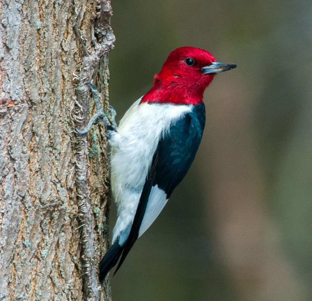
The Red-headed Woodpecker is a medium-sized woodpecker weighing 56-91 g and reaching a total length of 19-24 cm (Frei et al. 2015a). The species, whose plumage is identical in both males and females, is easily identified by its distinctive red head, neck, throat and upper breast (Sibley 2003; COSEWIC 2007). The body is white below and black above, with large white patches on the wings. The upper tail and rump are also white and the tail is black with white outer edges (COSEWIC 2007). No subspecies are recognized (Frei et al. 2015a). The Red-headed Woodpecker is omnivorous, consuming a wide variety of plant and animal food items, and forages on the ground, in trees, and in the air (reviewed in Frei et al. 2015a).
3.2 Species population and distribution
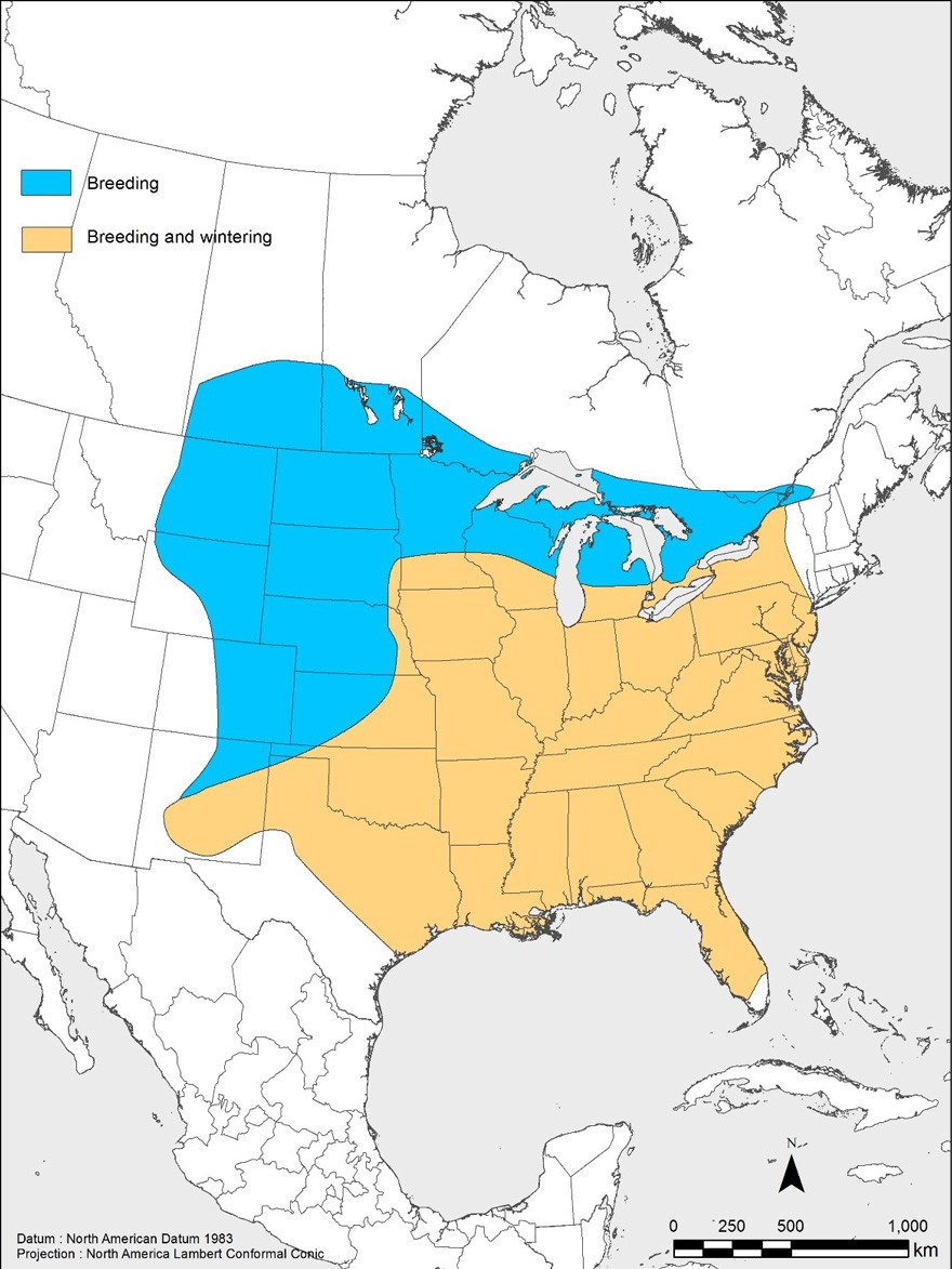
Red-headed Woodpeckers are only found in North America. The species range stretches from southern Saskatchewan east to southeastern Quebec, and south throughout the eastern half of the U.S. down to the Gulf coast (Figure 1). The areas with the highest densities of Red-headed Woodpecker during the breeding season are in the U.S. Midwest and Gulf coast states (Figure 2). In Canada, the Red-headed Woodpecker's breeding range extends from southern Saskatchewan (south of the boreal forest), through southern Manitoba (from Dauphin in the northwest, through the Interlake Region, to Sprague in the southeast), Ontario (south of Georgian Bay as well as in the Lake of the Woods township and the Ottawa River Valley) and into southwestern Quebec (particularly in the Outaouais, Montérégie and Haut-Richelieu regions (Figure 1). The species has been recorded in southern Alberta (near Medicine Hat and Red Deer, and possibly between those areas; D. Vujnovic, pers. comm. 2011); however the species is classified as accidental/vagrant
According to the North American Breeding Bird Survey (BBS) data, the global Red-headed Woodpecker population is estimated at 1.2 million individuals (Partners in Flight Science Committee 2013). The Canadian population is estimated at 8,000 individuals (5,000 individuals in Manitoba and 3,000 individuals in Ontario; Partners in Flight Science Committee 2013). This estimate is based on BBS data from Manitoba and Ontario only; Saskatchewan and Quebec are excluded from the analysis because of insufficient data (abundance in Saskatchewan is extremely low (Fig. 2) despite the large area of the province within which the species can be found (Fig. 1); in Quebec, abundance between 2010 and 2014 was also extremely low (Fig. 4)). The number of breeding pairs in Manitoba and Ontario accounts for less than 1% of the species' global breeding population, and their distribution covers about 6% of the species' global breeding range (1.9% in Manitoba and 4.3% in Ontario) (Partners in Flight Science Committee 2013).
Historical data are sparse across most of the Canadian range of Red-headed Woodpecker. It is thought to have been historically more abundant in the eastern parts of its range (i.e. Ontario and Quebec), but in Manitoba it was considered to be rare or uncommon (COSEWIC 2007). Saskatchewan is lacking enough historical data to identify a long-term trend for the species in that province (COSEWIC 2007), but it was likely never considered abundant.
Species abundance seems to have undergone a long-term decline since at least the 1970s (Sauer et al. 2014). Between 1970 and 2014, Rosenberg et al. (2016) estimate that the abundance of Red-headed Woodpecker in North America declined by approximately 86%. The following rates of population change for Red-headed Woodpecker in Canada have been estimated using BBS data from 1970 to 2015 (ECCC 2017), and applying a model similar to that used to generate published estimates for 1970-2012 (Environment Canada 2014a). The rates are based on data collected in Ontario and Manitoba; Saskatchewan and Quebec are excluded from the analysis because there are insufficient data from those two provinces to estimate trends (A.C. Smith, pers. comm. 2017). Approximately 60% of Red-headed Woodpeckers breeding in Canada are found within the area covered by the BBS routes used to calculate trends in Ontario and Manitoba. It is estimated that the annual rate of population change for the species in Canada has been -2.2% (95% CI
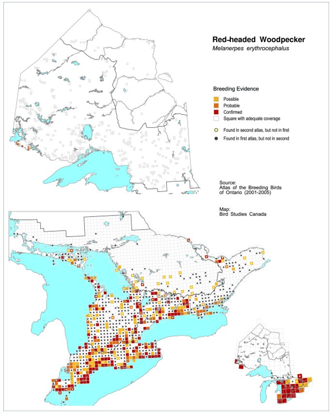
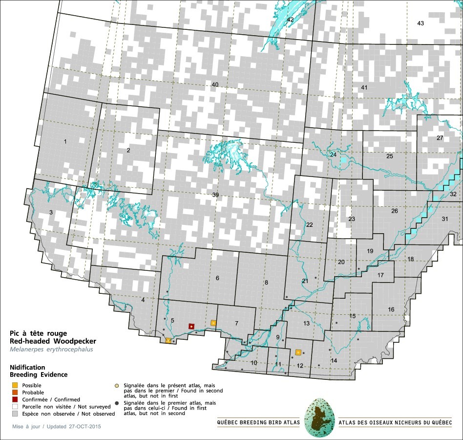
In addition to declining abundance, BBS data provides evidence of a reduction in the area of occupancy of breeding individuals in Ontario and Quebec (Figure 2). The second edition of the Atlas of the Breeding Birds of Ontario (Cadman et al. 2007) shows a reduction in the proportion of surveyed squares found to be occupied by the species from approximately 20% in 1980-1985 to 6 % in 2001-2005 (Table 2; Figure 3). Similarly, the Québec Breeding Bird Atlas (AONQ 2016) showed a reduction in occupancy from 1% of surveyed squares in 1984-1989 to <0.1% in 2010-2014 (Table 2; Figure 4). These results are consistent with the 2000-2005 New York State Breeding Bird Atlas data which recorded Red-headed Woodpecker in 76% fewer survey blocks compared to the 1980-1985 Atlas (McGowan and Corwin 2008).

| Provinces | Atlas periods | Number of occupied squares | Number of occupied squares with confirmed breeding | Number of well-sampled atlas squares | BBS annual trends 1970-2015 / 2005-2015 |
|---|---|---|---|---|---|
| Saskatchewanb,c | 1966-2014b | 24 | 2 | not available | Not available |
| Manitobad | 2010-2014 | 313 | 99 | 2,896 | -1.5% / -2.2% |
| Ontarioe | 1981-1985 | 732 | 313 | 3,727 | -3.8% / -2.7% |
| Ontarioe | 2001-2005 | 330 | 133 | 4,990 | -3.8% / -2.7% |
| Quebecf | 1984-1989 | 26 | 8 | 2,462 | Not available |
| Quebecf | 2010-2014 | 4 | 3 | 5,568 | Not available |
b The Saskatchewan Breeding Bird Atlas (SBBA) is an ongoing project not based on a standardized survey methodology. Data are reported continually in a web-based application. Atlas squares correspond to the National Topographic System 1: 250 000 grids rather than the standard 10 x 10 km used in other atlas projects.
c SBBA 2015;
d MBBA 2016;
e Cadman et al. 1987 and Cadman et al. 2007;
f Gauthier and Aubry 1996 and AONQ 2016.
3.3 Needs of the Red-headed Woodpecker
Breeding habitat
As illustrated by its higher relative abundance west of the Mississippi River compared to the more heavily forested north-eastern part of its range (Figure 2), the Red-headed Woodpecker is not primarily dependent on extensive forest cover. In general, higher densities of decadent trees are associated with higher habitat quality (Rodewald et al. 2005; King et al. 2007; Waldstein 2012; Frei et al. 2013; Hudson and Bollinger 2013; Kilgo and Vukovich 2014; Berl et al. 2015; Frei et al. 2015b; Anderson and LaMontagne 2016).
In Ontario and Quebec, Red-headed Woodpeckers are found in the Mixedwood Plains Ecozone
In Saskatchewan and Manitoba, Red-headed Woodpeckers are found in the Moist Mixed Grassland Ecoregion and the Aspen Parkland Ecoregion (both part of the Prairie Ecozone). Treed habitat in the grassland ecoregion tends to be riparian or associated with anthropogenic tree plantings. In the Parkland ecoregion, breeding habitat consists of open mature woodlots; aspen dominated forests with small amounts of elm and oak; bluffs (clumps or grove of trees) in pasture or cropland
Red-headed Woodpecker territory size during the breeding season ranges from 3.1 to 11.4 ha (Venables and Collopy 1989, Kilgo and Vukovich 2012). When snag
Nesting sites
Red-headed Woodpeckers excavate nesting cavities in decadent trees (reviewed in Sandilands 2010, Frei et al. 2015a). These trees tend to be large (Berl et al. 2015, Anderson and LaMontagne 2016): most nesting trees have a diameter-at-breast height (dbh) of 50 cm or more (Sandilands 2010), and a diameter at cavity height of 27 cm on average (King et al. 2007). However, the use of snags with a dbh as low as 18.4 cm has been reported in South Carolina (Kilgo and Vukovich 2014). In Canada, the species nests exclusively in deciduous trees, and nest trees are usually devoid of bark around the cavity (Jackson 1976). Cavity concealment appears to be an important characteristic of successful nesting sites, with the percentage of vegetative structure surrounding the cavity entrance positively affecting nest success (Berl et al. 2014). In addition to the breeding habitats described above, nesting trees can be located on forest edges and roadsides (reviewed in COSEWIC 2007 and Frei et al. 2015a).
Conflicting reports on Red-headed Woodpeckers nest fidelity may suggest that the frequency of cavity reuse varies across local populations. Several studies conducted in the U.S. documented cavity reuse, though no nests were reused in a study conducted in Wisconsin (King et al. 2007). A study in Ontario reported that 58 out of 60 monitored nests were newly excavated (see review in Frei et al. 2015a). Similarly, Sandilands (2010) states that breeding pairs almost always excavate a new cavity, (though the same tree can be used repeatedly).
The species occasionally uses nest boxes and old cavities excavated by other bird species; excavates cavities in posts and telephone poles (e.g. Jackson 1976); or usurps (takes over) active cavities of other species including Downy Woodpecker (Picoides pubescens) and Red-bellied Woodpecker (Melanerpes carolinus) (reviewed in Sandilands 2010, Frei et al. 2015a). Additional details on nesting sites can be found in Sandilands (2010).
Migration and wintering habitat
Although some individuals can be found in southwestern Ontario (i.e. the Carolinian zone) in some years during the winter months, most Red-headed Woodpeckers breeding in Canada are short-distance migrants that spend winters in the eastern half of the U.S. (which also serves as both breeding and wintering grounds for a portion of the American population; Figure 1). During winter, the species is most abundant in the Midwest where hard mast
Diet
The Red-headed Woodpecker is omnivorous, and the preponderance of vegetation in its diet varies greatly according to the season. In Ontario, insects (mainly aerial and those living on bark) make up two-thirds of the diet during spring migration (Sandilands 2010). This proportion shifts over the summer as more plant matter (mainly hard mast [acorns and beechnuts], fruit [cultivated and wild], corn, and seed) becomes more abundant. Insects consumed during the summer consist mostly of beetles but also grasshoppers, caterpillars, wasps, domesticated bees and some ants. Corn, apples, acorns and beechnuts are important during autumn migration, and the species relies almost exclusively on the latter two items in the winter (and corn in low-mast years), while invertebrates (mainly adult beetles) make up only 4% of the diet during that season (reviewed in Sandilands 2010, Frei et al. 2015a). It is assumed that its diet in the Canadian Prairies is different from that in Ontario and Quebec, given the lack of acorn and beechnut-producing trees, and differences in crop production. However, the relative importance of the diet components in Saskatchewan and Manitoba is not known.
As expected, the species forages on trees for wood-boring insects, but it is also one of the few woodpeckers that regularly forage on the ground (reviewed in Frei et al. 2015a). During the breeding season, the species spends a considerable amount of time fly-catching (i.e. flying out from a perch to catch insects in the air), and stooping (i.e. dropping down from a perch to catch prey on the ground) (reviewed in Frei et al. 2015a). The Red-headed Woodpecker is known to sally for insects up to 50 m from a perch (Skinner 1928).
Limiting factors
Limiting factors influence a species' survival and reproduction, and play a major role in its capacity to attain certain abundance levels.
Decadent trees
As mentioned above, Red-headed Woodpeckers require decadent trees in order to excavate cavities for nesting and roosting. Decadent trees are by their very nature a short-lived resource, and a continuous supply is necessary for habitat to maintain its suitability for the species. The hypothesis that availability of nesting sites is a limiting factor for the species is supported by the rapid increase in abundance of Red-headed Woodpeckers that followed an experimental pulse
Length of breeding season
In Canada, Red-headed Woodpeckers begin laying eggs the second week of May, which is relatively late in the spring compared to other woodpeckers (Rousseu and Drolet 2017). At the northern edge of their range, the species is typically single-brooded (Berl et al. 2013). In an Ontario study, Red-headed Woodpeckers had a low fledging success (39% of eggs resulted in a fledged young) and an annual fecundity rate unlikely to surpass the mortality rate (0.43 female fledglings per female per year) (Frei et al. 2015c). Low annual fecundity of Red-headed Woodpeckers in the northern portion of their range may make these local populations' persistence reliant on immigration from more southerly populations (Frei et al. 2015c).
Weather severity and mast availability in winter
During years of extreme cold and heavy snowfalls, the species is unlikely to be found wintering in southern Ontario; severe winters can also cause local population declines (reviewed in Sandilands 2010). Presence of the species during winter months in Ontario and the northern part of the U.S. is also correlated with the abundance of acorns and beechnuts, and Red-headed Woodpeckers will continue their migration until they reach an area where mast is sufficiently abundant to last the winter (COSEWIC 2007). Low availability of mast increases winter territory size, influences winter distribution and reduces abundance (reviewed in Sandilands 2010).
4. Threats
4.1 Threat assessment
The Red-headed Woodpecker threat assessment is based on the IUCN-CMP (World Conservation Union–Conservation Measures Partnership) unified threats classification system (Salafsky et al. 2008). Threats are defined as the proximate activities or processes that have caused, are causing, or may cause in the future the destruction, degradation, and/or impairment of the entity being assessed (local population, species, community, or ecosystem) in the area of interest (global, national, or subnational scale). Limiting factors are not considered during this assessment process. Historical threats, indirect or cumulative effects of the threats, or any other relevant information that would help understand the nature of the threats are presented in the Description of Threats section.
| Threat Type | Threat # | Threat Description | Extent | Impactg | Scopeh | Severityi | Timingj |
|---|---|---|---|---|---|---|---|
| 1. Residential and commercial development | 1.1 | Housing and urban areas | SK-MB-ON-QC | Low | Small | Extreme | High |
| 1. Residential and commercial development | 1.2 | Commercial and industrial areas | SK-MB-ON-QC | Negligible | Negligible | Extreme | High |
| 1. Residential and commercial development | 1.3 | Tourism and recreation areas | SK-MB-ON-QC | Negligible | Negligible | Serious | High |
| 2. Agriculture and aquaculture | 2.1 | Annual and perennial non-timber crops | SK-MB | Low | Restricted | Moderate | High |
| 2. Agriculture and aquaculture | 2.2 | Wood and pulp plantations | SK-MB-ON-QC | Negligible | Negligible | Serious-Moderate | High |
| 3. Energy production and mining | 3.1 | Oil and gas drilling | SK-MB-ON-QC | Negligible | Negligible | Moderate | Moderate |
| 3. Energy production and mining | 3.2 | Mining and quarrying | SK-MB-ON-QC | Negligible | Negligible | Extreme | High |
| 3. Energy production and mining | 3.3 | Renewable energy | SK-MB-ON-QC | Negligible | Negligible | Negligible | High |
| 4. Transportation and service corridors | 4.1 | Roads and railroads | SK-MB-ON-QC | Low | Pervasive | Slight | High |
| 4. Transportation and service corridors | 4.2 | Utility and Service lines | SK-MB-ON-QC | Unknown | Pervasive | Unknown | High |
| 5. Biological resource use | 5.3 | Logging and wood harvesting | SK-MB-ON-QC | Low | Restricted – Small | Moderate | High |
| 6. Human intrusions and disturbance | 6.1 | Recreational activities | SK-MB-ON-QC | Unknown | Small | Unknown | High |
| 7. Natural system modifications | 7.1 | Fire and fire suppression | ON-QC | Low | Small | Serious | High |
| 7. Natural system modifications | 7.3 | Other ecosystem modifications | SK-MB-ON-QC | High-Medium | Serious-Moderate | Serious | High |
| 8. Invasive and other problematic species and genes | 8.1 | Invasive non-native / alien species | SK-MB-ON-QC | Medium | Pervasive | Moderate | High |
| 8. Invasive and other problematic species and genes | 8.2 | Problematic native species | SK-MB-ON-QC | Unknown | Unknown | Unknown | High |
| 9. Pollution | 9.3 | Agricultural and forestry effluents | SK-MB-ON-QC | Unknown | Pervasive | Unknown | High |
| 11. Climate change and severe weather | 11.1 | Habitat shifting & alteration | SK-MB-ON-QC | Unknown | Unknown | Unknown | Moderate |
g Impact – The degree to which a species is observed, inferred, or suspected to be directly or indirectly threatened in the area of interest. The impact of each threat is based on Severity and Scope rating and considers only present and future threats. Threat impact reflects a reduction of a species population or decline/degradation of the area of an ecosystem. The median rate of population reduction or area decline for each combination of scope and severity corresponds to the following classes of threat impact: Very High (75% declines), High (40%), Medium (15%), and Low (3%). Unknown: used when impact cannot be determined (e.g., if values for either scope or severity are unknown); Not Calculated: impact not calculated as threat is outside the assessment timeframe (e.g., timing is insignificant/negligible or low as threat is only considered to be in the past); Negligible: when scope or severity is negligible; Not a Threat: when severity is scored as neutral or potential benefit.
h Scope – Proportion of the species that can reasonably be expected to be affected by the threat within 10 years. Usually measured as a proportion of the species' population in the area of interest. (Pervasive = 71–100%; Large = 31–70%; Restricted = 11–30%; Small = 1–10%; Negligible < 1%).
i Severity – Within the scope, the level of damage to the species from the threat that can reasonably be expected to be affected by the threat within a 10-year or three-generation timeframe. Usually measured as the degree of reduction of the species' population. (Extreme = 71–100%; Serious = 31–70%; Moderate = 11–30%; Slight = 1–10%; Negligible < 1%; Neutral or Potential Benefit ≥ 0%).
j Timing – High = continuing; Moderate = only in the future (could happen in the short term [< 10 years or 3 generations]) or now suspended (could come back in the short term); Low = only in the future (could happen in the long term) or now suspended (could come back in the long term); Insignificant/Negligible = only in the past and unlikely to return, or no direct effect but limiting.
k SK = Saskatchewan, MB = Manitoba, ON = Ontario, QC = Quebec.
4.2 Description of threats
A number of threats are contributing to the decline of Red-headed Woodpecker, and while each alone may have a high, medium, low, or negligible/unknown impact (see Table 3), the cumulative effect of some combination of these threats is expected to have a high impact on the population. The most significant of these may be ecosystem modifications that potentially affect the Red-headed Woodpecker's habitat quality and changes to insect prey availability.
The main threats thought to be driving the decline of Red-headed Woodpecker are discussed in this section. Threats with a negligible or unknown impact across the Canadian range are outlined in Appendix D.
IUCN Threat 7. Natural System Modifications
Threat 7.3 Other ecosystem modifications
This category includes a number of individual threats that collectively have a high to medium impact on the Red-headed Woodpecker in Canada.
Tree diseases
The net effect of widespread declines in the abundance of several tree species due to infestations by non-native insects and/or fungi on the Red-headed Woodpecker has not been specifically ascertained and may be mixed. For instance Dutch elm disease, a non-native fungus that affects all elm species (Ulmus sp.) within the bird's Canadian range, began decimating mature elm trees in Ontario in the 1950s (Waldron 2003). This large-scale increase in mature dead trees may have led to an initial increase in Red-headed Woodpecker abundance, a hypothesis that is consistent with the bird species' positive response to a pulse in snags (Kilgo and Vukovich 2014). However, in the long term the disease likely reduced the availability of nest sites (Adams and Wenger 2011) because few individual trees now survive long enough to attain large sizes (Waldron 2003). More recently the Emerald ash borer, a beetle species native to eastern Asia, has killed millions of ash trees (Fraxinus sp.) in southwestern Ontario, Quebec, Michigan and surrounding states since its discovery in North America in 2002 (Natural Resources Canada 2016). This introduced insect may have important impacts on the composition of affected forests and, depending on the extent of pre-emptive logging, reduced nest site availability without creating an initial snag pulse.
In addition to impacts on nest sites, tree diseases have also impacted the availability of certain Red-headed Woodpecker food sources. The chestnut blight is a fungus native to Asia (Tree Canada 2017) that decimated American Chestnut (Castanea dentata) across its entire range (southern Ontario and the eastern U.S.) following the blight's arrival in North America in 1904 (Waldron 2003). The fungus would have caused a major reduction in the availability of chestnuts as a food item for the species: in southern Ontario alone, it is estimated that American Chestnut trees numbered between 300,000 and 2 million before the blight's arrival, whereas by 1986 only 82 individuals over 10 cm in diameter could be found (Waldron 2003). Similarly, the ongoing loss of American Beech trees (Fagus grandifolia) in Ontario due to beech bark disease will reduce the amount of mast (beech nuts) available for Red-headed Woodpecker consumption if, as predicted by Waldron (2003), 50% of trees end up succumbing to the disease. This non-native insect- fungus complex arrived in the province in 1999 (Waldron 2003), and has not been present in Ontario long enough to assess its ecological impacts (McLaughlin and Greifenhagen 2012). Within the Red-headed Woodpecker range in Quebec, beech bark disease continues its progression in the Outaouais region, where the percentage of dead stems ranges from 3% to more than 31% in the most heavily infected areas (Roy and Nolet 2015). In addition, large individuals suffer high mortality rates (25% for trees greater than 30 cm dbh (reviewed in MFFP 2017).
Decadent tree removal
Dead and dying trees and tree limbs are usually removed for aesthetic and/or safety reasons in urbanized areas. In a study covering an entire county in Illinois, no nest trees were found in highly residential or business districts (Anderson and LaMontagne 2016). Similarly, while livestock grazing is positively associated with Red-headed Woodpeckers, the removal of decadent trees and other trees in pastures can reduce habitat quality and the availability of breeding and roosting sites for the species.
Changes to insect populations
Recent studies (e.g. Mineau and Whiteside 2013, Hallmann et al. 2014) have investigated the specific impact of pesticides on farmland bird populations from the overall impact of agricultural intensification. It is expected that insecticide applications on cropland result in declines in insect abundance in targeted areas, but it is unknown whether insecticide application is also negatively affecting invertebrates in the non-targeted habitat where the birds occur (i.e. woodlands and sparsely treed habitats adjacent to cropland). The acute decline in aerial insectivorous birds observed in North America and Europe is often attributed to a large-scale decline in flying insects (Nebel et al. 2010), caused by agricultural intensification. However, the animal component of the Red-headed Woodpecker diet is not restricted to flying insects, but includes insects that live on the ground and within or on the surface of wood. Beetles are the predominant insect in the species' summer diet and it is unknown whether they are declining in abundance or composition within the species' breeding habitat. Experiments have found that neonicotinoids are toxic to non-target invertebrates including carabid beetle larvae and adults (Pisa et al. 2015), and have a repellent effect on flies and beetles (Easton and Goulson 2013). It is not yet known the extent to which beetles are exposed to neonicotinoids in non-treated woodland and hedgerow habitats where the species forages.
Determining the degree to which any changes in insect populations would be a threat to Red-headed Woodpecker is complicated by the fact that the species is only partially dependent on insects. It is unknown whether the species has or would shift its diet towards a greater proportion of plant material in the event of a decline in its insect prey. More information is needed on Red-headed Woodpecker diet throughout its Canadian range.
Threat 7.1 Fire & fire suppression
Red-headed Woodpeckers' selection for habitat without tall woody understory vegetation (Berl et al. 2015) suggests that the suppression of fire, which would have historically maintained open understories in oak savannahs and woodlands, may lower the quality of Red-headed Woodpecker habitat. It is hypothesized that an open understory provides better fly-catching opportunities (Frei et al. 2015a). In addition, fire generates decadent trees (though it also destroys them). Overall, restoration of savannahs by fire appears to benefit Red-headed Woodpeckers (see brief review in Frei et al. 2015a), suggesting that succession of these habitats to closed-canopy woodlands in the absence of fire disturbance may be a threat to the species. Wildfires are now completely suppressed in southern Ontario, except for the small pockets of protected savannah habitats which are maintained through the use of prescribed burns.
Fire in the Aspen Parkland ecoregion of the Prairies prior to European settlement promoted rejuvenation of aspen stands (Guedo and Lamb 2013). Fire suppression has likely increased habitat quality in Manitoba and Saskatchewan by allowing a greater number of mature and dead aspen to remain on the landscape, and by favouring encroachment of aspen into grassland habitat. (ECCC 2016a, Kovatch 2015).
IUCN Threat 5. Biological resource use
Threat 5.3 Logging & wood harvesting
Wood harvesting can result in different impacts on Red-headed Woodpecker habitat, depending on the management system used. The clear-cut system which removes all trees in one cutting operation is not discussed as a forestry practice in this section because it now largely occurs for the purposes of residential/commercial development and agriculture in the range of the Red-headed Woodpecker.
While partial wood harvesting removes fewer trees within a woodlot than clear cutting, the removal of large decadent trees nevertheless destroys nests, and nesting and winter roosting trees. In the U.S., local declines of the Red-headed Woodpecker are probably linked to loss of nesting habitat as a result of forest clearing, in part from firewood cutting (NatureServe 2015). As decadent trees are often considered to be a nuisance or a likely safety hazard, they are typically removed from a woodlot during timber management operations (OMNR 2010). In addition, short-rotation harvests leads to low snag densities in logged woodlots (McComb et al. 1986, Ohmann et al. 1994). These forestry practices can significantly reduce the number of existing and potential Red-headed Woodpecker nesting sites, which is likely a limiting factor for the species. Indeed, several studies have shown that increased snag density can have a positive effect on cavity nesters (Kilgo and Vukovich 2014). In managed pine forests of South Carolina, for example, Red-headed Woodpecker abundance increased dramatically in areas with an increase in snag density compared to areas with low snag densities (Kilgo and Vukovich 2014).
This poses a greater threat in Ontario and Quebec than in the Prairie Provinces, as most of the species range in Saskatchewan and Manitoba does not overlap with the forestry industry’s harvesting activities. Red-headed Woodpeckers are typically not found in the densely treed provincial forests where most harvest occurs, but rather on the adjacent fragmented forest on private land (Figure C-2).
IUCN Threat 8. Invasive & Other Problematic Species & Genes
Threat 8.1 Invasive non-native/alien species
European Starlings
The non-native European Starling (Sturnus vulgaris; hereinafter, starling) harass native cavity-nesting birds over the use of cavities, and aggressive interactions between starlings and Red-headed Woodpeckers have been observed at Red-headed Woodpecker nest sites (Ingold 1994, Frei et al. 2015b). In a study in Ohio, Ingold (1994) found that 15% of Red-headed Woodpecker nest sites were usurped by starlings. In southern Ontario, Frei et al. (2015b) found that Red-headed Woodpecker nests were four times more likely to fail if starlings were present, and the frequency of starling sightings was a stronger predictor of nest survival than the habitat attributes used in the study's models. Red-headed Woodpeckers tend to occupy habitats with lower canopy closure (Frei et al. 2013), and not surprisingly, the frequency of starling sightings was higher at Red-headed Woodpecker nests located in open habitat (which included urban parks, golf courses and treed pastures) compared to woodlots (Frei et al. 2015b).
Despite documented Red-headed Woodpecker nest usurpation by starlings, interference competition between the two species may not necessarily pose a threat to Red-headed Woodpecker at the national population level. When comparing the mean densities of 27 native cavity-nesting birds at sites before and after the arrival of starlings, Koenig (2003) found no apparent effect of starlings on Red-headed Woodpeckers. In a subsequent analysis, Koenig et al. (2017) also found a poor correlation between starling abundance and the observed decline of Red-headed Woodpecker in the U.S. between 1960 and 2014. Note that these studies did not appear to control for effects of changes in forest cover that would benefit both species.
According to BBS long-term (1970-2012) and short-term (2002-2012) data, the annual trend for starling abundance is negative in all four Canadian provinces where the Red-headed Woodpecker occurs (Environment Canada 2014b). More specifically, the long-term and short-term negative trends for starlings hold across all portions of Bird Conservation Regions (BCR) that overlap with the Canadian range of Red-headed Woodpecker (Prairie Potholes (BCR 11) in Saskatchewan and Manitoba; Lower Great Lakes / St. Lawrence Plain (BCR 13) and Boreal Hardwood Transition (BCR 12) in Ontario and Quebec), with the exception of the short-term trend in the Saskatchewan portion of the Prairie Potholes BCR, which is positive at 0.736. This suggests that the overall impact from starlings, if any, is in decline across the Red-headed Woodpecker range in Canada.
Cats
Predation by the domesticated cat (Felis catus) is likely the largest source of human-related mortality of birds in Canada (Blancher 2013, Calvert et al. 2013) and in the U.S. (Loss et al. 2013). An estimated 2-7% of all birds in southern Canada (105–348 million birds) are killed by cats annually (Blancher 2013), and an estimated 1.3–4.0 billion annually in the U.S. (Loss et al. 2013). In Canada the kill rate by feral cats is higher than either urban or rural pet cats; feral cats accounted for 59% of mortalities despite comprising only 25% of all cats in Canada (Blancher 2013).
The impact of cat predation on birds at the population level is likely unequal across species, due to differences in nesting and other life history traits. Blancher (2013) did not include the Red-headed Woodpecker in his list of 115 bird species potentially more vulnerable to cat predation in Canada, even though the species appears to possess at least one of the characteristics used for inclusion on the list (it forages on the ground during the breeding season). The impact of cat predation on local Red-headed Woodpecker populations has not been determined. The number of cats in Canada, including feral cats, is expected to increase in future (Blancher 2013).
IUCN Threat 2. Agriculture & aquaculture
Threat 2.1 Annual & perennial non-timber crops
Forest clearing
The biggest driver of forest clearing in Canada is agriculture (Natural Resource Canada 2008) and the sector accounts for approximately two thirds of gross forest clearing nationally (Masek et al. 2011). The conversion of woodlands to agricultural lands removes trees used by Red-headed Woodpeckers for nesting and roosting, similar to the land conversion for development described in IUCN threat 1. In the U.S., local declines of the Red-headed Woodpecker are probably linked to loss of nesting habitat, in part as a result of forest clearing for agriculture (NatureServe 2015).
Manitoba, Saskatchewan
Conversion of native woodland and grassland habitats to agricultural lands in the Aspen Parkland ecoregion of Saskatchewan and Manitoba used to be promoted under economic development policy (e.g. Interlake Development Corporation 1973). However, the amount of land under annual crop production in the ecoregion has stabilized since the mid-1980s (Prairie Habitat Joint Venture 2014, Government of Saskatchewan 2015) and the loss of forested area since 2001 does not appear to be extensive (Hansen et al. 2013). On-going large-scale conversion of forest to agricultural land in Saskatchewan is occurring north of the species range in the Boreal Plains ecoregion (Hobson et al. 2002).
Ontario
Despite the decline in overall farmland area in southern Ontario (from 61% at its height in 1931 to 36% in 2011) (Smith 2015), about one half of land that was cleared of forest (3,558 ha) within this region of the province between 1990 and 2013 was converted to agriculture (Ontario Biodiversity Council 2015). The area under cropland has in fact remained relatively stable, fluctuating between 3 and 3.2 million hectares between 1921-2001 (Smith 2015). The overall decline in farmland is primarily due to decreases in pasture, woodland and wetland under farm ownership. Although Red-headed Woodpeckers use trees present in agricultural landscapes (see overview in Sandilands 2010), a decreasing number of decadent trees remain available in rural areas with intensifying agricultural practices (see Agricultural Intensification below).
Agricultural Intensification
Intensification includes the removal of hedgerows to create bigger crop fields, increased use of fertilizers and pesticides, increased soil drainage, and the conversion of pasture and hayfields to row crops, etc. (Rioux Paquette et al. 2014). A discussion of the potential impacts of pesticides on Red-headed Woodpecker can be found in Appendix D: Agriculture and forestry effluents (9.3).
Over the period of 1941 to 2011, the average farm size in Canada increased from 237 acres per farm to 779 acres (Statistics Canada). In Manitoba and Saskatchewan, the number of farms greater than 3,520 acres in size grew from 1,357 in 1976 to 5,568 in 2016, while the number of farms smaller than 3,520 decreased by 57% (Statistics Canada 2017). This intensification leads to loss of suitable habitat in the form of mature hedgerows, shelterbelts, aspen bluffs, and farm yards with scattered trees. In the prairie's Aspen Parkland ecoregion, crop fields are increasing at the expense of summer fallow (the practice of tilling weeds into the soil to rest the field). In Ontario, pasture and hay crops decreased by 80% and 45% respectively between 1921 and 2011 (Smith 2015). In Quebec, the St. Lawrence lowlands and Appalachian ecoregion has experienced a similar trend of agricultural intensification; annual crops are increasing at the expense of other forms of agriculture (Jobin et al. 2010).
IUCN Threat 1. Residential & Commercial Development
Threat 1.1 Housing & urban areas
Land Conversion
The conversion of woodlands to developed lands leads to the permanent loss or degradation of Red-headed Woodpecker habitat by removing trees that the species uses for nesting and roosting along with the features used for other life processes (open areas for foraging, etc.). Even when development does not result in the complete removal of trees, the habitat is degraded because suitable nesting sites (decadent trees) in urbanized areas are fewer (LaMontagne et al. 2015). Forest clearing for residential development in the U.S. may be linked not only to local declines (NatureServe 2015), but it may also be limiting the number of Red-headed Woodpeckers that return to breed in Canada each year.
Though the rate of forest-clearing in Canada has decreased since the 1990s, it remains higher than the combined reforestation and afforestation rates, at 35,000 ha/year (Masek et al. 2011). The southern part of Canada, where the Red-headed Woodpecker occurs, is the most populous region of the country and has experienced massive change over the last century. It is now a highly developed region dominated by urban and agricultural landscapes. Urban and industrial development accounts for 17% of gross forest-clearing at the national level (Masek et al. 2011), but this percentage varies across provinces.
Manitoba, Saskatchewan
There is little residential and commercial development expected within the species' range in Manitoba and Saskatchewan, given the low and declining human population in rural areas, where the majority of the Red-headed Woodpeckers occur (Markey et al. 2015).
Southern Ontario
By 1920, 94% of original upland forest in the Ontario portion of the Mixedwood Plains Ecozone had been lost to clearcutting (Larson et al. 1999), which largely corresponds to the Red-headed Woodpecker's range in Ontario. On the other hand, the species may have benefited from the opening up of the continuous forest cover by European settlers (and by First Nations prior to that). About one half of land cleared in southern Ontario between 2000 and 2011 (2,348 ha) was for urban development purposes (Ontario Biodiversity Council 2015). The threat from land-clearing for residential and commercial development is expected to continue given the human population growth projected for 2015-2041 within the species' range in Ontario (Ministry of Finance 2016).
Quebec
In the St. Lawrence Lowlands and the Appalachians ecoregions of southern Quebec, landscape changes between 1993 and 2001 show an increase in suburban sprawl of 2% and 1%, respectively, and an overall reduction in forest cover of 3% and less than1%, respectively (Jobin et al. 2010). For example, in metropolitan Montreal, built-up area increased from 130 km2 in 1951 to 1137 km2 in 2011 (Nazarnia et al. 2016).
Collisions with windows
It has been estimated that 25 million birds are killed each year in Canada from collisions with building windows (Machtans et al. 2013), and between 365 and 988 million each year in the U.S. (Loss et al. 2014a). Loss et al. (2014a) estimated that as a group, woodpeckers have a 1.4 times greater risk of colliding with buildings than a species with average risk, but they do not identify the Red-headed Woodpecker as a high-risk species. Red-headed Woodpeckers have been documented as victims of collisions with windows in the Greater Toronto Area and the Ottawa region (FLAP 2016).
Despite the much lower per-building mortality rate of houses compared to high-rises (Machtans et al. 2013, Loss et al. 2014a), it has been estimated that houses account for the overwhelming majority (90%) of total bird-building collision mortalities in Canada due to the sheer number of residential buildings present on the landscape (Machtans et al. 2013). Bird-building collision and mortality rates are higher for rural houses than urban houses, and for houses with bird feeders compared to those without them (Bayne et al. 2012, Machtans et al. 2013), though the high variance between houses suggests that the effect of feeders is dependent on house and window particulars (Kummer and Bayne 2015). Given that Red-headed Woodpeckers are more common in rural landscapes than urban areas, and that they may rely to some degree on suet feeders in winter (Sandilands 2010), it may be relevant to note that rural houses with feeders have the highest collision and mortality rates among residential buildings (Bayne et al. 2012, Machtans et al. 2013). However, the impact of bird-building collisions at a species or local population level is unknown.
IUCN Threat 4. Transportation & Service Corridors
Threat 4.1 Roads & railroads
Vehicle collisions
Vehicle collisions are known to be a threat to birds; in Canada 14 million birds are killed each year during the breeding season on roads outside of major urban centres (Bishop and Brogan 2013), and in the U.S an estimated 89-340 million birds die each year in collisions (Loss et al. 2014b). Collisions do not affect all species equally; Piciformes, the taxonomic order that includes woodpeckers, represented only 0.16% of estimated avian roadkill in Canada and 5.9% in the U.S (Bishop and Brogan 2013), though these numbers may be underestimates as several of the studies targeted specific orders or species.
It is hypothesized that the species is susceptible to colliding with vehicles due to its propensity for feeding along roadsides (Curry 2006); for staying on the road despite approaching vehicles and for their inability to quickly take flight when vehicles approach (Dill 1926; Sandilands 2010).
A few studies in the mid twentieth century observed Red-headed Woodpecker vehicle mortality rates ranging from 14-88% of all reported carcasses (Dill 1926; Scott 1938). These studies suggest that mortality due to vehicle collisions could be high for the species in particular localities and at certain times of year. In the U.S, six out of nine studies that, based on location and other recorded species, could have detected Red-headed Woodpecker did not observe the species. However, it is possible that the current rarity of the species impacts the frequency with which it is now reported as roadkill. A 1999 study in Wisconsin found that the species accounted for 0.26% of road-killed birds compared to 7.9% between 1932 and 1949 (Mueller 2001).
Manitoba, Saskatchewan
Manitoba and Saskatchewan have extensive road networks south of the boreal forest. Paved highways comprise 45% of the road surfaces in Manitoba (Manitoba Infrastructure and Transportation 2016) and 16% of total roads in Saskatchewan (Government of Saskatchewan 2017). Expansion of the road network is not a priority for either Manitoba's or Saskatchewan's highway departments.
Ontario
Based on the Ministry of Transportation's Ontario Road Map, there was a 69% increase in the length of roads in southern Ontario between 1935 and 2005 (Ontario Biodiversity Council 2015). Although the rate of increase of total road length in southern Ontario has slowed since 1985 (Ontario Biodiversity Council 2015), there is on-going road construction within the species range in the southern part of the province. The increase in traffic on existing roads is also likely to be a factor.
5. Population and distribution objectives
Despite the large, and in some areas irreversible, changes to the Red-headed Woodpecker’s habitat across its breeding, migrating and wintering ranges, there are currently sufficient numbers of reproducing individuals to maintain local breeding populations, such that it is not unreasonable to aim to stabilize and subsequently increase the Canadian population over a period of time.
- The short-term (10 years) population objective for the Red-headed Woodpecker in Canada is to halt the declining population trend.
- The long-term objective for the Red-headed Woodpecker in Canada is to achieve an increase in abundance of the species in Canada and achieve a self-sustaining population
footnote 14 and maintain or, where biologically and technically possible, increase the species' rangefootnote 15 and area of occupancyfootnote 16 .
These population and distribution objectives address the reasons for the species' designation as Threatened, which are: a) a small number of mature individuals, estimated at fewer than 10,000, together with b) an estimated continuing decline in total number of mature individuals of at least 10% within three generations (COSEWIC 2007).
A number of urgent- and high-priority recovery approaches have been identified in this recovery strategy in an effort to halt the declining population trend of the Red-headed Woodpecker within ten years, while minimizing the population decrease during the intervening time period. Given an average generation time for this species of 3-5 years, a 10-year timeframe was considered appropriate for the short-term objective because it is similar to the three-generation timeframe used by COSEWIC for assessing the conservation status of species.
Once the decline is halted, an increase in the Canadian population in the long term is targeted through the continued implementation of those approaches and others outlined in this document.
There is uncertainty in what constitutes the best achievable scenario for Red-headed Woodpecker in Canada, and so a quantitative long-term population objective is not identified at this time. Table 4 (Section 6.2) identifies an action that aims to refine understanding of the current and historical population abundance and distribution, as well as the extent of irreversible change, throughout the species' Canadian range to inform development of a quantitative long-term population objective. Broad strategies and approaches to achieve these objectives are outlined in this recovery strategy.
6. Broad strategies and general approaches to meet objectives
6.1 Actions already completed or currently underway
Numerous activities have been initiated since the latest COSEWIC assessment in 2007 that either include the Red-headed Woodpecker in the framework of activities or specifically targeted the species. The following list is not exhaustive, but is meant to illustrate the main areas where work is already underway, to give context to the broad strategies to recovery outlined in Table 4, section 6.2. Actions completed or underway include the following:
Canada
- Data collection on abundance and distribution of the species through Breeding Bird Surveys, breeding bird atlases, Project Nestwatch
footnote 17 , and the eBird databasefootnote 18 - Development of Bird Conservation Region strategies that identify conservation objectives and actions for priority bird species, including the Red-headed Woodpecker (Environment Canada 2014c)
- Publication of nesting phenology (Rousseu and Drolet 2017)
- Forest management guidelines with prescriptions specific to the management of Red-headed Woodpecker habitat have been developed and implemented by members of the forestry sector
Saskatchewan
- Saskatchewan Breeding Bird Atlas field surveys started in 2017
- Targeted surveys in the rural municipality of Corman Park and Duck Mountain Provincial Park in June 2015 (no Red-headed Woodpeckers were observed) (ECCC, unpublished data)
- Surveys on over 2000km of routes conducted in 2015 by the province (no Red-headed Woodpeckers were observed (C. Gaudet, pers. comm. 2015))
Manitoba
- Bird Studies Canada point count surveys conducted in 2008 and 2009 (for Golden-winged Warbler project) provided observations of Red-headed Woodpeckers (C. Artuso, pers. comm. 2016)
- Completion of the Breeding Bird Atlas in Manitoba for 2010-2014
Ontario
- Development of best forest management practices to maintain important habitat features for the Red-headed Woodpecker, for example "The Species at Risk Steward's Guide Series" (Muskoka Heritage Foundation 2015), "The Forest Management Guide for Conserving Biodiversity at the Stand and Site Scale" (OMNR 2010) and "A Land Manager's Guide to Conserving Habitat for Forest Birds in Southern Ontario" (OMNR 2011))
- Management and stewardship of savannah and woodland habitats, surveys, and public engagement projects funded by the federal Habitat Stewardship Program (HSP)
Quebec
- Restoration of nesting sites undertaken in 2008, funded by the HSP, with a goal to increase snag density in order to encourage birds to nest
- Species at risk monitoring by Regroupement QuébecOiseaux (Suivi des espèces en péril (SOS-POP). This program consists of monitoring nesting sites (active and historical) of species at risk, which led to the publication of a report on Red-headed Woodpecker nesting sites from 1960 to 2014 (Lang 2015)
6.2 Strategic direction for recovery
| Threat or Limitationl | Broad Strategy to Recovery | Prioritym | General Description of Research and Management Approachesn |
|---|---|---|---|
| 1. Residential & commercial development 2.1 Annual & perennial non-timber crops 5.3 Logging & wood harvesting 7.3 Other ecosystem modifications |
Habitat conservation and management | Urgent |
|
| 1. Residential & commercial development 2.1 Annual & perennial non-timber crops 3.2 Mining & Quarrying 5.3 Logging & wood harvesting 7.3 Other ecosystem modifications |
Habitat conservation and management | High |
|
| 5.3 Logging & wood harvesting 7.1 Fire & fire suppression 7.3 Other ecosystem modifications 8.2 Problematic native species |
Habitat conservation and management | High |
|
| 7.3 Other ecosystem modifications 9.3 Agricultural & forestry effluents |
Habitat conservation and management | High |
|
| 7.3 Other ecosystem modifications 8.1 Invasive non-native/alien species |
Habitat conservation and management | Medium |
|
| Knowledge gaps | Monitoring and research | High |
|
| Knowledge gaps | Monitoring and research | High |
|
| Knowledge gaps | Monitoring and research | Medium |
|
| Knowledge gaps | Monitoring and research | Medium |
|
| Knowledge gaps | Monitoring and research | Medium |
|
| 7.3 Other ecosystem modifications 9.3 Agricultural & forestry effluents |
Monitoring and research | High |
|
4.1 Roads & railroads 4.2 Utility & service lines |
Monitoring and research | Medium |
|
| 7.3 Other ecosystem modifications 8.1 Invasive non-native/alien species 8.2 Problematic native species |
Monitoring and research | Low |
|
| 6.1 Recreational activities | Monitoring and research | Low |
|
| 5.3 Logging & wood harvesting | Law and policy | High |
|
| 7.3 Other ecosystem modifications 9.3 Agricultural & forestry effluents |
Law and policy | Medium |
|
| 1.1 Housing & urban areas 1.2 Commercial & industrial areas 3.3 Renewable energy 4.1 Roads & railroads 4.2 Utility & service lines |
Law and policy | Medium |
|
| 5.3 Logging & wood harvesting 7.3 Other ecosystem modifications |
Education and awareness, stewardship, and partnerships | High |
|
| Knowledge gaps | Education and awareness, stewardship, and partnerships | Medium |
|
| 8.1 Invasive non-native/alien species | Education and awareness, stewardship, and partnerships | Medium |
|
| All threats | Education and awareness, stewardship, and partnerships | Medium |
|
l For more information on threats, see Section 4.
m "Priority" reflects the degree to which the broad strategy contributes directly to the recovery of the species or is an essential precursor to an approach that contributes to the recovery of the species.
n E.g. "The Forest Management Guide for Conserving Biodiversity at the Stand and Site Scale" (OMNR 2010) or "A Land Manager's Guide to Conserving Habitat for Forest Birds in Southern Ontario" (OMNR 2011)).
7. Critical habitat
Section 41(1)(c) of SARA requires that recovery strategies include an identification of the species' critical habitat, to the extent possible, as well as examples of activities that are likely to result in its destruction. under section 2(1) of SARA, critical habitat is "the habitat that is necessary for the survival or recovery of a listed wildlife species and that is identified as the species' critical habitat in the recovery strategy or in an action plan for the species".
7.1 Identification of the species' critical habitat
This recovery strategy identifies critical habitat across the species' range, based on the best available information for the Red-headed Woodpecker as of January 2016 for Ontario, as of April 2017 for Quebec, and as of August 2017 for Saskatchewan and Manitoba.
Critical habitat for the Red-headed Woodpecker is partially identified and is insufficient to meet the population and distribution objectives. A schedule of studies has been developed to provide the information necessary to complete the identification of critical habitat. Within the areas containing critical habitat (based on species observations, see section 7.1.1), critical habitat occurs where the biophysical attribute criteria are met (section 7.1.2) (Figure 5).
7.1.1 Areas containing critical habitat
In Canada, an area containing critical habitat has been identified using Red-headed Woodpecker observations that indicate the species presence (in breeding and/or wintering seasons) and observation type (nest or observation documented during standardized surveys or incidental observation), since 2001. Setting the cut-off year at 2001 allows for the inclusion of all data collected for the most recent applicable breeding bird atlas editions (Atlas of the Breeding Birds of Ontario, 2001–2005 (Cadman et al. 2007), Atlas of the Breeding Birds of Quebec, 2010-2014 (AONQ 2016), and Manitoba Breeding Bird Atlas (MBBA 2016)). Other data sources available include species-specific surveys, Breeding Bird Surveys, Conservation Data Centre data repositories, and citizen science initiatives such as Project FeederWatch and eBird.
Species presence
During the breeding season
Areas containing critical habitat are based on observations of Red-headed Woodpecker (active nests or individuals without confirmed nests), during the breeding season, recorded between May 11th in the southern part of Ontario (i.e. Bird Conservation Region 13
An observation is considered evidence of species presence during the breeding season when:
- it was an observation of the species that meets the definition of either confirmed or probable breeding evidence
footnote 21
OR - it was an observation of the species that meets the definition of "possible breeding", and it is located within 600 m
footnote 22 ,footnote 23 of another observation of any category (i.e. confirmed/probable/possible breeding), and the two observations are either dated at least one week (7 days)footnote 24 apart or anytime in another breeding seasonfootnote 25
During the wintering season
Areas containing critical habitat are based on observations of Red-headed Woodpecker in Ontario, during the wintering season, recorded between November 1st and April 19th
An observation is considered for species presence during the wintering season when:
- it was an observation of the species recorded within a distance of 600 m or less, at least 5 weeks
footnote 27 apart from another observation during the same winter season, or anytime in another winter season
Delineation of critical habitat based on observation
Areas containing critical habitat for Red-headed Woodpecker are delineated from observations (as described above) as follows:
- when the observation consists of a nest cavity location (during the breeding season only), an area with a radius of 200 m centered on the observation location: radius of 190 m to include the breeding pair's territory
footnote 28 , plus 10 m to account for location accuracy;
OR - when the observation is of an individual or individuals (i.e. non-nest observations, during either breeding and/or wintering season
footnote 29 ), an area with a radius of 600 m centered on the observation (human observer) location: 200 m to account for the maximum likely distance between the observer and the bird, plus 10 m to account for location accuracy of observer, plus 380 m to include the diameter of the territory, plus 10 m to include a potential nest/roost tree's dripline
7.1.2 Biophysical attributes of critical habitat
The biophysical attributes of habitats in which individuals may carry out breeding (e.g., courtship, territory defence, nesting, and post-fledgling), roosting and foraging activities in Canada include:
1) potential nesting/roosting structures: decadent deciduous trees that are 18 cm dbh or more or have dead or dying limb(s) with a diameter of 13
2) habitat that is located up to 190 m from the dripline
- Treed areas
footnote 32 for breeding, roosting, and foraging, including:- in Ontario and Quebec: treed areas such as savannahs and deciduous upland, floodplain and riparian woodlands dominated by maples, oak, hickory and/or beech (including those subjected to burns and/or logging), low-canopy deciduous and mixed
footnote 33 forests or forest habitat near gap or edge habitat, and hedgerows, golf courses, parks, cemeteries, and orchards; OR - in Saskatchewan and Manitoba: sparsely treed woodlands such as those dominated by aspen with some elm and oak; bluffs (clumps or grove of trees) with an open or grazed understory located within pasture, crop fields, farm yards and urbanized areas; hedgerows and shelterbelts with mature and decadent elm, maple and/or ash trees, and; sparsely treed riparian habitat with aspen, cottonwood and oak
- understory vegetation within treed areas
- fruit- and mast-bearing trees/bushes to provide food sources
- coarse woody debris within treed areas
- in Ontario and Quebec: treed areas such as savannahs and deciduous upland, floodplain and riparian woodlands dominated by maples, oak, hickory and/or beech (including those subjected to burns and/or logging), low-canopy deciduous and mixed
- other non-built-up areas containing vegetation that supports food sources AND that are located up to 50 m
footnote 34 from the dripline of a decadent tree described under 1) and/or the edge of habitat described under 2a). Habitat types may include, but are not limited to, the following examples:- pastures
- grasslands
- old fields
- wetlands
- shrublands
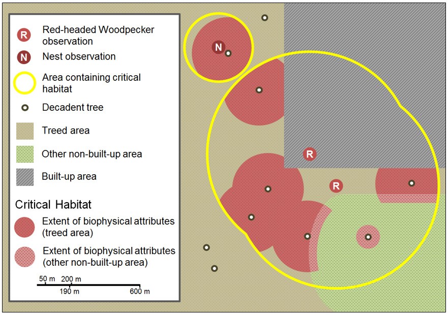
7.1.3 Application of the critical habitat criteria
Critical habitat for Red-headed Woodpecker is identified as the extent of the biophysical attributes (section 7.1.2) wherever they occur within the areas containing critical habitat (section 7.1.1).
In applying the critical habitat criteria above to the best available data, the areas containing critical habitat are identified for the Red-headed Woodpecker in Canada in Figures C-1 to C-4 (see also Tables C-1 to C-4). The critical habitat identified is considered a partial identification of critical habitat and is insufficient to meet the Canadian population and distribution objectives for the Red-headed Woodpecker. A schedule of studies (section 7.2) has been developed to provide the information necessary to complete the identification of critical habitat that will be sufficient to meet these objectives.
The areas containing critical habitat identified for the Red-headed Woodpecker are presented using a 10 x10 km UTM grid
7.2 Schedule of studies to identify critical habitat
| Description of Activity | Rationale | Timeline |
|---|---|---|
| Working with landowners across the species range in Canada, survey, where feasible, the areas where the species has been observed, but for which the accuracy, precision, or confidence in recent habitat use by Red-headed Woodpeckers did not allow for their identification as areas containing critical habitat. | Location obtained so that sufficient critical habitat is identified to meet the population and distribution objectives. | 2021 to 2026 |
| Estimate the amount of critical habitat available within the areas that contain critical habitat and determine if additional areas containing critical habitat are required to support meeting the long-term population and distribution objectives. | Potential critical habitat deficiencies are identified so that sufficient critical habitat can be identified to meet the population and distribution long-term objectives. | 2026 to 2041 |
7.3 Activities likely to result in the destruction of critical habitat
Understanding what constitutes destruction of critical habitat is necessary for the protection and management of critical habitat. Destruction is determined on a case by case basis. Destruction would result if part of, or all critical habitat was degraded, either permanently or temporarily, such that it would not serve its function when needed by the species. Destruction may result from a single activity or multiple activities at one point in time or from the cumulative effects of one or more activities over time. It should be noted that not all activities that occur in or near critical habitat are likely to cause its destruction. Activities described in Table 6 are examples of those likely to cause destruction of critical habitat for the species; however, destructive activities are not necessarily limited to those listed.
| Description of Activity | Description of effect in relation to function loss | Details of effect |
|---|---|---|
| Complete removal of a treed area; Partial removal of a treed area under the following tree harvesting systems: clear-cuto, diameter-limit cutting, and high-grading. |
The removal of a treed area eliminates, either in whole or in part, the ecosystem upon which the species relies for basic survival, including the elements of the habitat that are used for breeding, foraging, roosting and over-wintering. | If this activity occurs within critical habitat, at any time of year, the effects will be direct, and are certain to result in the destruction of critical habitat. Removal of some trees using best forest management practicesp and undertaken under the following tree harvesting systems is not likely to result in the destruction of critical habitat: shelterwood, group selection, or single tree selection. |
| Removal of decadent deciduous trees (i.e. trees with cavities, dead/dying trees, and trees with dead or dying limbs 13 cm in diameter or larger) and other standing trees with an18 cm dbh or greater. | This activity results in the direct loss of occupied or potential nest/roost sites and in a reduction of the food supply (wood-dwelling insects). The removal of non-decadent standing trees can result in a reduced future supply of nesting/roosting features. | If this activity occurs within critical habitat, at any time of year, the effects will be direct, and in most instances result in the destruction of critical habitat. Single-tree selection logging that retains/supplies a minimum of 5 decadent deciduous trees per hectareq while maintaining the configuration and extent of critical habitat and is undertaken according to best forest management practices is not likely to result in the destruction of critical habitat. |
| Construction of built structures (including houses/ buildings, roads, and wind turbines); establishment of aggregate pits, quarries and mines. | Residential and commercial development, road construction and mineral resource extraction result in the removal of soil and vegetation that produce insects consumed by Red-headed Woodpecker. The loss of soil and vegetation can also directly reduce the species’ food supply by removing plant material that also forms an important component of the species’ diet. | If this activity occurs within critical habitat, at any time of year, the effects will be direct, and in most instances will result in the permanent destruction of critical habitat. The construction of a given building may not result in the destruction of critical habitat if biophysical attributes are not removed. |
| Clearing or destruction of understory vegetation (e.g. grass or shrub layers) or other non-built-up areas. | Clearing or destruction of understory vegetation or other non-built-up areas can indirectly lead to loss of food resources and reduced foraging potential because understory vegetation is required to produce the insects that are consumed by Red-headed Woodpeckers and other non-built-up areas are required adjacent to decadent trees and treed areas to provide foraging opportunities. | If this activity occurs within critical habitat, at any time of year, it may result in the destruction of critical habitat. However, some vegetation clearing could be used to maintain/create habitat suitable for Red-headed Woodpeckers. For example, habitat management activities that open up the understory (e.g. to maintain open treed habitat such as savannah) may not result in the destruction of critical habitat. Vegetation removal activities to maintain the supply of suitable open treed habitat should be approached at a landscape scale while considering the availability of adjacent/nearby habitat to ensure that sufficient suitable habitat and resources will be available in a given year. The anticipated net effect of habitat management activities should be evaluated on a case-by-case basis. Habitat management activities should be developed using a holistic ecosystem-based approach to ensure that the needs of other species at risk are addressed. Temporary removal of vegetation that supports food sources (e.g. seasonal harvests of crops) may not result in the destruction of critical habitat if carried out outside of the breeding season (before May 11th in the southern part of Ontario (i.e. Bird Conservation Region 13) or May 20th elsewhere in Canada, and after August 18th). |
| Removal or destruction of native fruit-bearing trees/bushes. | Removal of native fruit-bearing trees and bushes can result in loss of food resources (fruits and berries), reducing foraging potential. Removal of exotic invasive trees and bushes would not result in destruction of critical habitat. | If this activity occurs within critical habitat, at any time of year, it is likely to result in the destruction of critical habitat. |
| Removal of coarse woody debris. | Removal of coarse woody debris can result in loss of food resources (insects), reducing foraging potential. | If this activity occurs within critical habitat, at any time of year, it is likely to result in the destruction of critical habitat. |
oDefinitions of silvicultural methods/harvesting systems.
pE.g. "The Forest Management Guide for Conserving Biodiversity at the Stand and Site Scale" (OMNR 2010) or "A Land Manager's Guide to Conserving Habitat for Forest Birds in Southern Ontario" (OMNR 2011)).
qThe decadent tree retention threshold is based on Red-headed Woodpecker requirements (OMNR 2011).
8. Measuring progress
The performance indicators presented below provide a way to define and measure progress toward achieving the population and distribution objectives for Red-headed Woodpecker in Canada. Specific progress towards implementing the recovery strategy will be measured against indicators outlined in subsequent action plans.
Every five years, success of recovery strategy implementation will be measured against the following performance indicators:
- Population size and trends will be estimated using Breeding Bird Survey and provincial breeding bird atlas data to evaluate whether a) the declining population trend has halted within 10 years and b) an increase in abundance and a self-sustaining population have been achieved over the long term
- Over the long term, the extent of occurrence and Index of Area of Occupancy will be used to evaluate whether the species' range
footnote 36 and area of occupancy, respectively, have been maintained or increased
9. Statement on action plans
One or more action plans will be completed for the Red-headed Woodpecker by December 31, 2026. Parks Canada multi-species action plans identify recovery measures specific to national parks and other national heritage places where species occur (for a list of current multi-species action plans including the Red-headed Woodpecker, refer to the documents section of the SARA Public Registry).
10. References
Adams, R.J. and T. Wenger. 2011. Red-headed Woodpecker (Melanerpes erythrocephalus), in A.T. Chartier, J.J. Baldy, and J.M. Brenneman (eds.). The Second Michigan Breeding Bird Atlas. Kalamazoo Nature Center, Kalamazoo, Michigan. [accessed September 2015].
Anderson, E.C. and J.M. LaMontagne. 2016. Nest selection by red-headed woodpeckers across three spatial scales in an urban environment. Urban Ecosystems 19(1):297-314.
AONQ (Atlas des oiseaux nicheurs du Québec). 2016. Résultats de l'atlas (cartes) pour le Pic à tête rouge, Atlas des oiseaux nicheurs du Québec, Regroupement QuébecOiseaux, Environnement et Changement climatique Canada et Études d'Oiseaux Canada, Québec (Québec). [Accessed January 2016]. Available in English: Québec Breeding Bird Atlas. 2016. Atlas results (maps) for red-headed woodpecker. Québec Breeding Bird Atlas, Regroupement QuébecOiseaux, Environment and Climate Change Canada and Bird Studies Canada, Québec City, Quebec.
Artuso, C., pers. comm. 2016. Email correspondence to V. Snable.February 2016. Bird Studies Canada, Winnipeg, Manitoba.
Bayne, E.M., C.A. Scobie and M. Rawson-Clark. 2012. Wildlife Research 39(7):583 – 592.
Berl, J. L., J. W. Edwards, and J. S. Bolsinger. 2013. Attempted conspecific cavity usurpation by red-headed woodpeckers (Melanerpes erythrocephalus). Canadian Field-Naturalist 127:343–345.
Berl, J.L., J.W. Edwards, J.S. Bolsinger, and T.E. Katzner. 2014. Survival of red-headed woodpecker (Melanerpes erythrocephalus) nests in northern New York. The Wilson Journal of Ornithology 126:700-707.
Berl, J.L., J.W. Edwards, and J.S. Bolsinger. 2015. Scale-dependent and multi-metric nest habitat thresholds for red-headed woodpecker at the northern periphery of their range. The Condor 117: 203-216.
BirdLife International and NatureServe. 2014. Bird species distribution maps of the world. BirdLife International, Cambridge, UK and NatureServe, Arlington, U.S.
BirdLife International. 2016. Melanerpes erythrocephalus. The IUCN Red List of Threatened Species 2016: e.T22680810A92879799. [accessed April 2017].
Bishop, C.A. and J.M. Brogan. 2013. Estimates of avian mortality attributed to vehicle collisions in Canada. Avian Conservation and Ecology 8(2):2.
Blancher, P. 2013. Estimated number of birds killed by House Cats (Felis catus) in Canada. Avian Conservation and Ecology 8(2):3.
Bock, C.E. and L.W. Lepthien. 1975. A Christmas counts analysis of woodpecker abundance in the United-States. The Wilson Bulletin 87:355-366.
Both, C. and M.E. Visser. 2001. Adjustment to climate change is constrained by arrival date in a long-distance migrant bird. Nature 411: 296-298.
Cadman, M.D., P.F.J. 1861 Eagles, F.M. Helleiner (eds.). Atlas of the Breeding Birds of Ontario, 1981-1985. 1862 Federation of Ontario Naturalists, Long Point Bird Observatory. Waterloo, 1863 Ontario, Canada. xxii + 611 pp.
Cadman, M.D., D.A. Sutherland, G.G. Beck, D. Lepage, and A.R. Couturier (eds.). 2007. Atlas of the Breeding Birds of Ontario, 2001–2005. Bird Studies Canada, Environment Canada, Ontario Field Ornithologists, Ontario Ministry of Natural Resources, Ontario Nature. xxii + 706 pages.
Calvert, A.M., C.A. Bishop, R.D. Elliot, E.A. Krebs, T.M. Kudd, C.S. Machtans, and G.J. Robertson. 2013. A synthesis of human-related avian mortality in Canada. Avian Conservation and Ecology 8(2):11.
CAPP. 2015b. The Canadian oil and natural gas industry across Canada: Ontario. Canadian Association of Petroleum Producers. [accessed August 2015].
COSEWIC. 2007. COSEWIC assessment and update status report on the red-headed woodpecker Melanerpes erythrocephalus in Canada. Committee on the Status of Endangered Wildlife in Canada, Ottawa, Ontario. vi + 27 pp.
COSEWIC. 2015. COSEWIC assessment process, categories and guidelines. Committee on the Status of Endangered Wildlife in Canada, Ottawa, Ontario. 19 pp.
Curry, Bob. 2006. Birds of Hamilton and surrounding areas. Hamilton Naturalists' Club. Hamilton, Ontario. 676 pp.
DeGraaf, R.M.G., M. Witman, J.W. Lanier, B.J. Hill, and J.M. Keniston. 1980. Forest habitat for birds of the Northeast. USDA Forest Service, Radnor, Pennsylvania.
Dill, H. R. 1926. Is the automobile exterminating the woodpecker? Science, New Series 63:69–70.
Easton, A.H. and D. Goulson. 2013. The neonicotinoid insecticide imidacloprid repels pollinating flies and beetles at field-realistic concentrations. PLoS ONE 8(1): e54819. doi:10.1371/journal.pone.0054819.
eBird. 2015. eBird: an online database of bird distribution and abundance [web application]. eBird, Cornell Lab of Ornithology, Ithaca, New York. [accessed: October 2015].
ECCC (Environment and Climate Change Canada). 2016a. Tway National Wildlife Area Management Plan. Environment and Climate Change Canada, Edmonton, Alberta. 47 pp.
ECCC (Environment and Climate Change Canada). 2016b. Incidental take of migratory birds. Environment and Climate Change Canada, Gatineau, Québec. [accessed March 2016].
ECCC (Environment and Climate Change Canada). 2017. North American Breeding Bird Survey - Canadian Trends Website, Data-version 2015. Environment and Climate Change Canada, Gatineau, Quebec, K1A 0H3.
Environment Canada. 2014a. Trend results for red-headed woodpecker, North American breeding bird survey - Canadian trends website, data-version 2012. Environment Canada, Gatineau, Quebec. [accessed February 2017].
Environment Canada. 2014b. Trend results for European starling, North American breeding bird survey - Canadian trends website, data-version 2012. Environment Canada, Gatineau, Quebec. [accessed February 2017].
Environment Canada. 2014c. Bird conservation regions and conservation strategies. Environment Canada, Gatineau, Québec. [accessed May 2017].
FLAP. 2016. Canada Bird Species List. Fatal Light Awareness Program Canada. [accessed January 2016].
Frei, B., K. G. Smith, J. H. Withgott and P. G. Rodewald. 2015a. Red-headed woodpecker (Melanerpes erythrocephalus), in P. G. Rodewald (ed.). The Birds of North America. [accessed November 2016].
Frei, B., J.J. Nocera, and J.W. Fyles. 2015b. Interspecific competition and nest survival of the threatened red-headed woodpecker. Journal of Ornithology 156:743-753.
Frei, B., J.W. Fyles, J.L. Berl, J.W. Edwards, and J.J. Nocera. 2015c. Low fecundity of red-headed woodpeckers (Melanerpes erythrocephalus) at the northern edge of the range. The Wilson Journal of Ornithology 127(4): 639-654.
Frei, B., J.W. Fyles, and J.J. Nocera. 2013. Maladaptive habitat use of a North American woodpecker in population decline. Ethology 119:1-12.
Gaudet, C., pers. comm. 2015. Email correspondence to S. Lee. July 2015. Zoologist, Saskatchewan Conservation Data Centre, Regina, Saskatchewan.
Gauthier, J., and Y. Aubry (eds.). 1996. The Breeding Birds of Southern Québec: Atlas of the Breeding Birds of Southern Québec. L'Association québécoise des groups d'ornithologues, Province of Québec Society for the Protection of Birds, Canadian Wildlife Service, Environment Canada Québec Region. Montréal, Québec. 1302 pp.
Gibbons, D., Morrissey, C. & Mineau, P. 2015. A review of the direct and indirect effects of neonicotinoids and fipronil on vertebrate wildlife. Environ Sci Pollut Res 22:103-118.
Goulson, D. 2013. Review: An overview of the environmental risks posed by neonicotinoid insecticides. Journal of Applied Ecology 50:977-987.
Government of Alberta. 2011. Definitions of General Status Categories (PDF, 31 kb). Government of Alberta. [accessed March 2017]
Government of Alberta. 2017. Alberta wild species general status listing - 2015 (PDF, 826 kb). Government of Alberta.
Government of Manitoba. 2017. Manitoba Land Initiative (web application). Government of Manitoba, Winnipeg, Manitoba. [accessed April 2017].
Government of Saskatchewan. 2015. 2015 State of the Environment Report. Ministry of Environment, Government of Saskatchewan, Regina, Saskatchewan. 89 pp.
Government of Saskatchewan. 2017. About Highways and Infrastructure. Government of Saskatchewan, Regina, Saskatchewan. [accessed April 2017].
Graber, J.W., and R.R. Graber. 1977. Illinois birds: Picidae. Biological Notes Number 102. Illinois Natural History Survey, Urbana, Illinois. 73 pp.
Guedo, D. D. and E.G. Lamb. 2013. Prescribed burning has limited long-term effectiveness in controlling trembling aspen (Populus tremuloides) encroachment into fescue grassland in Prince Albert National Park. Canadian Field-Naturalist 127(1):50-56.
Hallmann, C.A., R.P.B. Foppen, C.A.M. van Turnhout, H. de Kroon, and E. Jongejans. 2014. Declines in insectivorous birds are associated with high neonicotinoid concentrations. Nature 511:341-343.
Hansen, M. C., P. V. Potapov, R. Moore, M. Hancher, S. A. Turubanova, A. Tyukavina, D. Thau, S. V. Stehman, S. J. Goetz, T. R. Loveland, A. Kommareddy, A. Egorov, L. Chini, C. O. Justice, J. R. G. Townshend. 2013. High-resolution global maps of 21st-century forest cover change. Science 342:850–3.
Hobson, K.A. and E. Bayne. 2000. The effects of stand age on avian communities in aspen-dominated forests of central Saskatchewan, Canada. Forest Ecology and Management 136:121-134.
Hobson, K.A., E. M. Bayne and S. L Van Wilgenburg. 2002. Large-scale conversion of forest to agriculture in the boreal plains of Saskatchewan. Conservation Biology 16:1530-1542.
Huber, D.G. and J. Gulledge. 2011. Extreme weather and climate change: understanding the link, managing the risk. Center for Climate and Energy Solutions, Arlington, VA.
Hudson, N.C. and E.K. Bollinger. 2013. Nest success and nest site selection of red-headed woodpeckers (Melanerpes erythrocephalus) in east-central Illinois. American Midland Naturalist 170:86-94.
Hydro One Network. 2016. Supply to Essex County. [accessed March 2017]
Ingold, D.J. 1994. Influence of nest-site competition between European starlings and woodpeckers. The Wilson Bulletin, 106(2): 227-241.
Interlake Development Corporation. 1973. The Land in the Middle (Manitoba's Interlake). Gordon Publishers, Selkirk, Manitoba. 74 pp.
Jackson, J.A. 1976. A comparison of some aspects of the breeding ecology of red-headed and red-bellied woodpeckers in Kansas. Condor 78:67-76.
Jobin, B., C. Latendresse, M. Grenier, C. Maisonneuve, and A. Sebbane. 2010. Recent landscape change at the ecoregion scale in southern Quebec (Canada), 1993–2001. Environmental Monitoring and Assessment 164:631-647.
Kilgo, J.C. and M.A. Vukovich. 2012. Factors affecting breeding season survival of red-headed woodpeckers in South Carolina. Journal of Wildlife Management 76:328-335.
Kilgo, J.C. and M.A. Vukovich. 2014. Can snag creation benefit a primary cavity nester: response to an experimental pulse in snag abundance. Biological Conservation 171:21-28.
King, R.S., K.E. Brashear, and M. Reiman. 2007. Red-headed woodpecker nest-habitat thresholds in restored savannas. Journal of Wildlife Management 71:30-35.
Koenig, W.D. 2003. European starlings and their effect on native cavity-nesting birds. Conservation Biology 17:1134–1140.
Koenig, W.D., E.L. Walters, and P.G. Rodewald. 2017 Testing alternative hypotheses for the cause of population declines: the case of the red-headed Woodpecker. The Condor 119(1):143-154.
Kovatch, L.C. 2015. The response of the avian community to 40 years of land cover change within the aspen parkland and moist-mixed grassland ecoregions of the Canadian Prairies. M.Sc. thesis, University of Regina, Regina, Saskatchewan. 74 pp.
Kummer, J. A., and E. M. Bayne. 2015. Bird feeders and their effects on bird-window collisions at residential houses. Avian Conservation and Ecology 10(2):6.
LaMontagne, J.M., R.J. Kilgour, E.C. Anderson, and S. Magle. 2015. Tree cavity availability across forest, park, and residential habitats in a highly urban area. Urban Ecosystem 18:151-167.
Lang, Y. 2015. Portrait des sites de nidification du pic à tête rouge au Québec – Analyse complète des mentions SOS-POP, de 1960 à 2014. Regroupement QuébecOiseaux, Montréal, Québec. 22 p.
Larson, B. M. , Riley, J. , Snell, E. and Godschalk, H. 1999. The woodland heritage of southern Ontario: a study of ecological change, distribution and significance. Federation of Ontario Naturalists. Don Mills, ON. 262 p.
Longcore, T., C. Rich, P. Mineau, B. MacDonald, D. G. Bert, L. M. Sullivan, E. Mutrie, S. a. Gauthreaux, M. L. Avery, R. L. Crawford, A. M. Manville, E. R. Travis, and D. Drake. 2013. Avian mortality at communication towers in the U.S. and Canada: Which species, how many, and where? Biological Conservation 158:410–419.
Loss, S.R., T. Will and P.P. Marra. 2013. The impact of free-ranging domestic cats
on wildlife of the United States. Nature Communications 4:1396 DOI: 10.1038/ncomms2380.
Loss, S.R., T. Will, S.S. Loss and P.P. Marra. 2014a. Bird-building collisions in the United States: estimates of annual mortality and species vulnerability. Condor 116:8-23.
Loss, S.R., T. Will, and P.P. Marra. 2014b. Estimation of bird-vehicle collision mortality on U.S. roads. The Journal of Wildlife Management 78:763-771.
Louisiana-Pacific Canada Ltd. 1995. Forest Management License #3 Ten-Year Forest Management Plan 1996-2005. Volume 1.
Louisiana-Pacific Canada Ltd. 2006. Forest Management License #3 Ten-Year Forest Management Plan 1996-2005. Volume 1.
Machtans, C.S., C.H.R. Wedeles, and E.M. Bayne. 2013. A first estimate for Canada of the number of birds killed by colliding with building windows. Avian Conservation and Ecology 8(2): 6.
Main, A.R., J.V. Headley, K.M. Peru, N.L. Michel, A.J. Cessna, and C.A. Morrissey. 2014.Widespread use and frequent detection of neonicotinoid insecticides in wetlands of Canada's prairie pothole region. PLoS ONE 9(3): e92821. doi:10.1371/journal.pone.0092821
Manitoba Infrastructure and Transportation. 2016. Annual report of the Department of Infrastructure and Transportation 2015-2016. Government of Manitoba, Winnipeg, Manitoba. [accessed April 2017].
Manitoba Hydro. 2017. Transmission expansion. Manitoba Hydro, Winnipeg, Manitoba.
Markey, S., S.-P. Breen, A. Lauzon, R. Gibson, L. Ryser, R. Mealy (eds.). 2015. State of Rural Canada Report. Canadian Rural Revitalization Foundation. iii + 109 pp.
Martin, T.E. and G. R. Geupel. 1993. Nest-monitoring plots: methods for locating nests and monitoring success. Journal of Field Ornithology 64: 507-519.
Masek, J.G, W.B. Cohen, D. Leckie, M.A. Wulder, R. Vargas, B. de Jong, S. Healey, B. Law, R. Birdsey, and R. Houghton. 2011. Recent rates of forest harvest and conversion in North America. Journal of Geophysical Research 116, G00K03, doi:10.1029/2010JG001471.
Master, L. L., D. Faber-Langendoen, R. Bittman, G. A. Hammerson, B. Heidel, L. Ramsay, K. Snow, A. Teucher, and A. Tomaino. 2012. NatureServe Conservation Status Assessments: Factors for Evaluating Species and Ecosystem Risk (PDF, 2.2 MB). NatureServe, Arlington, Virginia. [accessed October 2015].
MBBA (Manitoba Breeding Bird Atlas). 2016. Manitoba Breeding Bird Atlas. Bird Studies Canada, Winnipeg, Manitoba. [accessed January 2016].
McComb, W.C., Bonney, S.A., Sheffield, R.M., Cost, N.D., 1986. Snag resources in Florida - are they sufficient for average populations of primary cavity-nesters? Wildlife Society Bulletin 14:40-48.
McLaughlin, J. and S. Greifenhagen. 2012. Beech Bark Disease in Ontario:
A Primer and Management Recommendations. Ontario Forest Research Institute, Ontario Ministry of Natural Resources, Sault Ste Marie, Ontario. 8pp.
McGowan, K.J. and K. Corwin. 2008. The second atlas of the breeding birds of New York State. Cornell University Press.
MFFP (Ministère des Forêts, de la Faune et des Parcs). 2017. Gros plan sur les forêts : la maladie corticale du hêtre. Government of Quebec, Québec City, Quebec. [accessed April 2017].
Mineau, P. and M. Whiteside. 2013. Pesticide acute toxicity is a better correlate of U.S. grassland bird declines than agricultural intensification. PLoS ONE 8(2): e57457. doi:10.1371/journal.pone.0057457
Ministry of Finance. 2016. Ontario Population Projections Update, 2015-2041. Government of Ontario. [accessed April 2017].
MOECC (Ministry of the Environment and Climate Change). 2017. Neonicotinoid regulations. Government of Ontario. [accessed March 2017].
Mueller, W. 2001. Vehicle-caused mortality and the red-headed woodpecker in Wisconsin. The Passenger Pigeon 63(4):261-263.
Muskoka Heritage Foundation. 2015. Red-headed woodpecker (Melanerpes erythrocephalus) (PDF, 626 KB). Species at risk steward's guide series. [accessed November 2015].
Natural Resource Canada. 2016. Top forest insects and diseases in Canada: the emerald ash borer. Natural Resource Canada. [accessed May 2016].
NatureServe. 2015. NatureServe Explorer: an online encyclopedia of life [web application]. Version 7.1. NatureServe, Arlington, Virginia. [accessed August 2015].
Nazarnia, N., C. Schwick, J. A.G. Jaeger. 2016. Accelerated urban sprawl in Montreal, Quebec City, and Zurich: Investigating the differences using time series 1951–2011. Ecological Indicators 60 (2016) 1229–1251.
Nebel, S., A. Mills, J.D. McCracken, and P.D. Tayor. 2010. Declines of aerial insectivores in North America follow a geographic gradient. Avian Conservation Ecology 5(2):1.
Ohmann, J.L., McComb, W.C., Zumrawi, A.A., 1994. Snag abundance for primary cavity-nesting birds on nonfederal forest lands in Oregon and Washington. Wildlife Society Bulletin 22:607–620.
OMNR. 2010. Forest Management Guide for Conserving Biodiversity at the Stand and Site Scales. Ontario Ministry of Natural Resources, Government of Ontario, Toronto, Ontario. 211pp.
OMNR. 2011. A land manager's guide to conserving habitat for forest birds in southern Ontario. Ontario Ministry of Natural Resources. 136pp. [accessed November 2016].
OMNR. 2012. Land Information Ontario [web application]. Ontario Ministry of Natural Resources.
Ontario Biodiversity Council. 2015. State of Ontario's biodiversity 2015 indicators. Ontario Biodiversity Council, Peterborough, Ontario. [accessed: April 2017].
Partners in Flight Science Committee. 2013. Population estimates database, version 2013. [accessed Oct 2016].
Pisa, L.W., V. Amaral-Rogers, L.P. Belzunces, J.M. Bonmatin, C.A. Downs, D. Goulson, D. P. Kreutzweiser, C. Krupke, M. Liess, M. McField, C. A. Morrissey, D. A. Noome, J. Settele, N. Simon-Delso, J. D. Stark, J. P. Van der Sluijs, H. Van Dyck, and M. Wiemers. 2015. Effects of neonicotinoids and fipronil on non-target invertebrates. Environmental Science and Pollution Research 22(1):68-102.
Prairie Habitat Joint Venture. 2014. Prairie Habitat Joint Venture implementation plan 2013-2020: the prairie parklands. Environment Canada, Edmonton, Alberta. 30 pp.
Regroupement QuébecOiseaux. 2017. Suivi des espèces en péril (SOS-POP). Regroupement QuébecOiseaux, Montreal, Quebec. [accessed May 2017].
Rioux, S., J.-P. Savard, and A.A. Gerick. 2013. Avian mortalities due to transmission line collisions: a review of current estimates and field methods with an emphasis on applications to the Canadian electric network. Avian Conservation and Ecology 8(2): 7.
Rioux Paquette, S., F. Pelletier, D. Garant, and M. Bélisle. 2014. Severe recent decrease of adult body mass in a declining insectivorous bird population. Proceedings of the Royal Society B: Biological Sciences 281(1786):1-9.
Rodewald, P.G., M.J. Santiago, and A.D. Rodewald. 2005. Habitat use of breeding red-headed woodpeckers on golf courses in Ohio. Wildlife Society Bulletin 33:448-453.
Rosenberg, K.V., J A. Kennedy, R. Dettmers, R.P. Ford, D. Reynolds, J.D. Alexander, C.J. Beardmore, P.J. Blancher, R.E. Bogart, G.S. Butcher, A.F. Camfield, A. Couturier, D.W. Demarest, W.E. Easton, J.J. Giocomo, R.H. Keller, A.E. Mini, A.O. Panjabi, D.N. Pashley, T.D. Rich, J.M. Ruth, H. Stabins, J. Stanton, and T. Will. 2016. Partners in Flight landbird conservation plan: 2016 revision for Canada and continental United States. Partners in Flight Science Committee. [accessed Sept 2016].
Rousseu, F. and B. Drolet. 2017. The nesting phenology of birds in Canada. Canadian Wildlife Service, Technical Report Series No. 533, Environment and Climate Change Canada, Québec Region, Québec, Canada xxii + 316pp.
Roy, M-E. and P. Nolet. 2015. Typologie et caractérisation spatiale de l'envahissement et de la maladie corticale du hêtre en Outaouais. Institut des Sciences de la Forêt tempérée. Université du Québec en Outaouais. Ripon, Qc. Rapport technique. 62 p. + Annexes.
Rumsey, R. L. 1970. Woodpecker nest failures in creosoted utility poles. The Auk 87:367-369.
Salafsky, N., D. Salzer, A.J. Stattersfield, C. Hilton-Taylor, R. Neugarten, S.H.M. Butchart, B. Collen, N. Cox, L.L. Master, S. O'Connor, and D. Wilkie. 2008. A standard lexicon for biodiversity conservation: unified classifications of threats and actions. Conservation Biology 22:897–911.
Sandilands, A. 2010. Birds of Ontario: habitat requirements, limiting factors, and status: Volume 2–Non passerines: shorebirds through woodpeckers. UBC Press. 392 pp.
Santiago, M.J. 2004. Conservation of red-headed woodpeckers (Melanerpes erythrocephalus) on midwestern golf courses: a case study in Ohio. M.Sc. thesis, Ohio State University, Columbus, Ohio.
SaskPower. 2017. Construction Projects. SaskPower, Regina, Saskatchewan.[accessed April 2017].
Sauchyn, D. and S. Kulshreshtha. 2008. Prairies. Pp 275-328. in D.S. Lemmen, F.J. Warren, J. Lacroix, and E. Bush (eds). From impacts to adaptation: Canada in a changing climate 2007, Government of Canada, Ottawa, Ontario.
Sauer, J.R., J.E. Hines, J.E. Fallon, K.L. Pardieck, D.J. Ziolkowski, Jr., and W.A. Link. 2014. The North American Breeding Bird Survey, Results and Analysis 1966 - 2013. Version 01.30.2015. USGS Patuxent Wildlife Research Center, Laurel, Maryland.
SBBA (Saskatchewan Breeding Bird Atlas). 2015. Red-headed woodpecker data. Bird Studies Canada, Saskatoon, Saskatchewan. [accessed September 2015].
Scott, T.G. 1938. Wildlife mortality on Iowa highways. American Midland Naturalist 20:527–539.
Sibley D.A. 2003. The Sibley field guide to birds of eastern North America. Chanticleer Press, New York, New York. 433 pp.
Skinner, M. P. 1928. A guide to the winter birds of the North Carolina Sandhills. Albany, NY: Sci. Press Printing Co.
Smith, A.C., pers. comm. 2017. Email correspondence to K. Pickett. March 2017. Senior Biostatistician, Environment and Climate Change Canada, Government of Canada, Ottawa, Ontario.
Smith, Paul G.R. 2015. Long-term temporal trends in agri-environment and agricultural land use in Ontario, Canada: transformation, transition and significance. Journal of Geography and Geology 7(2) 32-55.
Stanton, R.L., C.A. Morrissey, and R.G. Clark. 2016. Tree swallow (Tachycineta bicolor) foraging responses to agricultural land use and abundance of insect prey. Can. J. Zool. 94:637–642.
Statistics Canada. 2017. Table 004-0005 - Census of Agriculture, farms classified by size of farm, Canada and provinces, every 5 years (1976 - 2016), CANSIM (database). (accessed: 17 January 2018).
Tree Canada. 2017. Chestnut Blight. Tree Canada, Ottawa, Ontario. [accessed May 2017].
Vandall, J.P., N. Henderson, and J. Thorpe. 2006. Suitability and adaptability of current protected area policies under different climate change scenarios: the case for the prairie ecozone, Saskatchewan. Saskatchewan Research Council, Regina, Saskatchewan.117 pp.
Van Sleeuwen, M. 2006. Natural fire regimes in Ontario. Ontario Ministry of Natural Resources, Toronto. 143p.
Venables, A. and M. W. Collopy. 1989. Seasonal foraging and habitat requirements of red-headed Woodpeckers in north-central Florida. Florida Game and Fresh Water Fish Commission, Tallahassee, Florida.
Vujnovic, D. pers. comm. 2011. Email correspondence to T. Kraus. February 2011. Parks Zoologist, Alberta Tourism Parks and Recreation, Edmonton, Alberta.
Waldron, G. 2003. Trees of the Carolinian forest. Boston Mills Press, Erin, Ontario. 275 pp.
Waldstein, A.L. 2012. Nest-site selection and nesting ecology of red-headed woodpeckers. M.Sc. thesis, University of Minnesota. [accessed Oct 2016].
Westworth, D.A. and E.S. Telfer. 1993. Summer and winter bird populations associated with five age-classes of aspen forest in Alberta. Canadian Journal of Forest Research 23(9):1830-1836.
Zimmerling, J. R., A. C. Pomeroy, M. V. d'Entremont, and C. M. Francis. 2013. Canadian estimate of bird mortality due to collisions and direct habitat loss associated with wind turbine developments. Avian Conservation and Ecology 8(2): 10.
Zimmerling, J.R., pers. comm. 2016. Email correspondence to K. Pickett. December 2016. Canadian Wildlife Service, Environment and Climate Change Canada, Government of Canada, Gatineau, Quebec.
Zomer, R.J., A. Trabucco, L.V. Verchot, and B. Muys. 2008. Land area eligible for afforestation and reforestation within the clean development mechanism: a global analysis of the impact of forest definition. Mitigation and Adaptation Strategies for Global Change 13:219–239.
Appendix A: Subnational conservation status ranks of Red-headed Woodpecker (Melanerpes erythrocephalus) in the United States
| Country (N Rank) |
State or Province (S Rank) |
|---|---|
| United States (N5B, N5N) | Alabama (S5), Arkansas (S4B,S4S5N), Colorado (S3B), Connecticut (S1), Delaware (S1), District of Columbia (S1N,SHB), Florida (SNR), Georgia (S4), Illinois (S5), Indiana (S4), Iowa (S5B), Kansas (S5B), Kentucky (S4B,S4N), Louisiana (S4), Maryland (S4), Massachusetts (S1B,S2N), Michigan (S5), Minnesota (SNRB,SNRN), Mississippi (S4S5), Missouri (SNRB,SNRN), Montana (S3B), Nebraska (S5), New Hampshire (SNA), New Jersey (S2B,S2N), New Mexico (S3B,S3N), New York (S2?B), North Carolina (S4B,S4N), North Dakota (SNRB), Ohio (S5), Oklahoma (S4S5), Pennsylvania (S4B,S4N), Rhode Island (S1B,S1N), South Carolina (SNR), South Dakota (S5B), Tennessee (S4), Texas (S3B), Vermont (S1B), Virginia (S4B), West Virginia (S2B,S3N), Wisconsin (S3B), Wyoming (S3B) |
Source: NatureServe 2015
| Rank | Definition |
|---|---|
| N1 S1 |
Critically Imperiled— At very high risk of extirpation in the jurisdiction due to very restricted range, very few populations or occurrences, very steep declines, severe threats, or other factors. |
| N2 S2 |
Imperiled— At high risk of extirpation in the jurisdiction due to restricted range, few populations or occurrences, steep declines, severe threats, or other factors. |
| N3 S3 |
Vulnerable— At moderate risk of extirpation in the jurisdiction due to a fairly restricted range, relatively few populations or occurrences, recent and widespread declines, threats, or other factors. |
| N4 S4 |
Apparently Secure— At a fairly low risk of extirpation in the jurisdiction due to an extensive range and/or many populations or occurrences, but with possible cause for some concern as a result of local recent declines, threats, or other factors. |
| N5 S5 |
Secure— At very low or no risk of extirpation in the jurisdiction due to a very extensive range, abundant populations or occurrences, with little to no concern from declines or threats. |
| N#N# S#S# |
Range Rank— A numeric range rank (e.g., S2S3 or S1S3) is used to indicate any range of uncertainty about the status of the species or ecosystem. Ranges cannot skip more than two ranks (e.g., SU is used rather than S1S4). |
| SH | Possibly Extirpated— Known from only historical records but still some hope of rediscovery. There is evidence that the species or ecosystem may no longer be present in the jurisdiction, but not enough to state this with certainty. Examples of such evidence include (1) that a species has not been documented in approximately 20-40 years despite some searching and/or some evidence of significant habitat loss or degradation; (2) that a species or ecosystem has been searched for unsuccessfully, but not thoroughly enough to presume that it is no longer present in the jurisdiction. |
| SNA | Not Applicable— A conservation status rank is not applicable because the species or ecosystem is not a suitable target for conservation activities. |
| SNR | Unranked— Conservation status not yet assessed. |
| SU | Unrankable— Currently unrankable due to lack of information or due to substantially conflicting information about status or trends. |
| B | Breeding |
| N | Non-breeding |
| M | Migrant |
Appendix B: Breeding evidence
Category: Possible Breedingfootnote 37
Code Description of behaviour
- H
- Species observed in its breeding season in suitable nesting habitat.
- S
- Singing male present, or breeding calls heard, in its breeding season in suitable nesting habitat.
Category: Probable Breeding
Code Description of behaviour
- P
- Pair observed in their breeding season in suitable nesting habitat.
- T
- Permanent territory presumed through registration of territorial song on at least 2 days, a week or more apart, at the same place.
- D
- Courtship or display between a male and a female or 2 males, including courtship feeding or copulation.
- V
- Visiting probable nest site.
- A
- Agitated behaviour or anxiety calls of an adult.
- B
- Brood patch on adult female or cloacal protuberance on adult male.
- N
- Nest-building or excavation of nest hole.
Category: Confirmed Breeding
Code Description of behaviour
- DD
- Distraction display or injury feigning.
- NU
- Used nest or egg shell found (occupied or laid within the period of the study).
- FY
- Recently fledged young or downy young, including young incapable of sustained flight.
- AE
- Adults leaving or entering nest site in circumstances indicating occupied nest.
- FS
- Adult carrying faecal sac.
- CF
- Adult carrying food for young.
- NE
- Nest containing eggs.
- NY
- Nest with young seen or heard.
Appendix C: Critical habitat for the Red-headed Woodpecker in Canada
| 1 x 1 km Standardized UTM grid square IDr | UTM Grid Square Coordinatess Easting |
UTM Grid Square Coordinatess Northing |
Land Tenuret |
|---|---|---|---|
| 13UER9402 | 590000 | 5542000 | Non-federal Land |
| 13UER9403 | 590000 | 5543000 | Non-federal Land |
| 13UER9412 | 591000 | 5542000 | Non-federal Land |
| 13UER9413 | 591000 | 5543000 | Non-federal Land |
| 13UFR7812 | 671000 | 5582000 | Non-federal Land |
| 13UFR7813 | 671000 | 5583000 | Non-federal Land |
| 13UFR7814 | 671000 | 5584000 | Non-federal Land |
| 13UFR7822 | 672000 | 5582000 | Non-federal Land |
| 13UFR7823 | 672000 | 5583000 | Non-federal Land |
| 13UCQ0507 | 300000 | 5457000 | Non-federal Land |
| 13UCQ0508 | 300000 | 5458000 | Non-federal Land |
| 13UCQ0509 | 300000 | 5459000 | Non-federal Land |
| 13UCQ0517 | 301000 | 5457000 | Non-federal Land |
| 13UCQ0518 | 301000 | 5458000 | Non-federal Land |
| 13UCQ0519 | 301000 | 5459000 | Non-federal Land |
| 13UEU4176 | 547000 | 5816000 | Non-federal Land |
| 13UEU4175 | 547000 | 5816000 | Non-federal Land |
r Square ID is based on the standard UTM Military Grid Reference System, where the first two digits and letter represent the UTM Zone, the following two letters indicate the 100 km x 100 km standardized UTM grid, the next two digits represent the 10 km x 10 km standardized UTM grid, and the final two numbers represent the 1km x 1km standardized UTM grid containing all or a portion of the area containing critical habitat. This unique alphanumeric code is based on the methodology used for the Breeding Bird Atlases of Canada.
s The listed coordinates represent the southwest corner of the 1 km x 1 km standardized UTM grid containing all or a portion of the area containing critical habitat. The coordinates may not fall within critical habitat and are provided as a general location only.
t Land tenure is provided as an approximation of the types of land ownership that exist within the area containing critical habitat and should be used for guidance purposes only. Accurate land tenure will require cross-referencing critical habitat boundaries with surveyed land parcel information.
| 10 x 10 km Standardized UTM grid square IDu | UTM Grid Square Coordinatesv Easting |
UTM Grid Square Coordinatesv Northing |
Land Tenurew |
|---|---|---|---|
| 14ULA65 | 360000 | 5550000 | Non-federal land |
| 14ULB43 | 340000 | 5630000 | Non-federal land |
| 14ULB62 | 360000 | 5620000 | Non-federal land |
| 14ULB81 | 380000 | 5610000 | Non-federal land |
| 14ULB98 | 390000 | 5680000 | Non-federal land |
| 14ULA80 | 380000 | 5500000 | Non-federal land |
| 14ULC59 | 350000 | 5790000 | Non-federal land |
| 14ULC90 | 390000 | 5700000 | Non-federal land |
| 14ULC67 | 360000 | 5770000 | Non-federal land |
| 14ULC91 | 390000 | 5710000 | Non-federal land |
| 14ULD50 | 350000 | 5800000 | Non-federal land |
| 14ULV77 | 370000 | 5470000 | Non-federal land |
| 14ULV78 | 370000 | 5480000 | Non-federal land |
| 14ULV87 | 380000 | 5470000 | Non-federal land |
| 14ULV88 | 380000 | 5480000 | Non-federal land |
| 14ULV89 | 380000 | 5490000 | Non-federal land |
| 14UMA00 | 400000 | 5500000 | Non-federal land |
| 14UMA30 | 430000 | 5500000 | Non-federal land |
| 14UMA57 | 450000 | 5570000 | Non-federal land |
| 14UMA58 | 450000 | 5580000 | Non-federal land |
| 14UMA66 | 460000 | 5560000 | Non-federal land |
| 14UMA47 | 440000 | 5570000 | Non-federal land |
| 14UMA78 | 470000 | 5580000 | Non-federal land |
| 14UMA84 | 480000 | 5540000 | Non-federal land |
| 14UMA89 | 480000 | 5590000 | Non-federal land |
| 14UMA94 | 490000 | 5540000 | Non-federal land |
| 14UMB20 | 420000 | 5600000 | Non-federal land |
| 14UMB21 | 420000 | 5610000 | Non-federal land |
| 14UMB80 | 480000 | 5600000 | Non-federal land |
| 14UMB81 | 480000 | 5610000 | Non-federal land |
| 14UMB25 | 420000 | 5650000 | Non-federal land |
| 14UMB26 | 420000 | 5660000 | Non-federal land |
| 14UMB91 | 490000 | 5610000 | Non-federal land |
| 14UMB92 | 490000 | 5620000 | Non-federal land |
| 14UMB93 | 490000 | 5630000 | Non-federal land |
| 14UMB96 | 490000 | 5660000 | Non-federal land |
| 14UMB30 | 430000 | 5600000 | Non-federal land |
| 14UMB31 | 430000 | 5610000 | Federal protected area (Riding Mountain National Park) and non-federal land |
| 14UMC50 | 450000 | 5700000 | Non-federal land |
| 14UMC52 | 450000 | 5720000 | Non-federal land |
| 14UMC62 | 460000 | 5720000 | Non-federal land |
| 14UMB35 | 430000 | 5650000 | Non-federal land |
| 14UMB44 | 440000 | 5640000 | Non-federal land |
| 14UMB45 | 440000 | 5650000 | Non-federal land |
| 14UMB51 | 450000 | 5610000 | Federal protected area (Riding Mountain National Park) |
| 14UMB53 | 450000 | 5630000 | Non-federal land |
| 14UMB54 | 450000 | 5640000 | Non-federal land |
| 14UMB60 | 460000 | 5600000 | Non-federal land |
| 14UMB61 | 460000 | 5610000 | Federal protected area (Riding Mountain National Park) and non-federal land |
| 14UMB63 | 460000 | 5630000 | Non-federal land |
| 14UMB69 | 460000 | 5690000 | Non-federal land |
| 14UMV03 | 400000 | 5430000 | Non-federal land |
| 14UMV09 | 400000 | 5490000 | Non-federal land |
| 14UMV13 | 410000 | 5430000 | Non-federal land |
| 14UMV79 | 470000 | 5490000 | Non-federal land |
| 14UMV85 | 480000 | 5450000 | Non-federal land |
| 14UMV77 | 470000 | 5470000 | Non-federal land |
| 14UNA15 | 510000 | 5550000 | Non-federal land |
| 14UNA40 | 540000 | 5500000 | Non-federal land |
| 14UNB42 | 540000 | 5620000 | Non-federal land |
| 14UNB43 | 540000 | 5630000 | Non-federal land |
| 14UNB03 | 500000 | 5630000 | Non-federal land |
| 14UNB12 | 510000 | 5620000 | Non-federal land |
| 14UNB20 | 520000 | 5600000 | Non-federal land |
| 14UNB21 | 520000 | 5610000 | Non-federal land |
| 14UNB23 | 520000 | 5630000 | Non-federal land |
| 14UNB24 | 520000 | 5640000 | Non-federal land |
| 14UNB25 | 520000 | 5650000 | Non-federal land |
| 14UNB29 | 520000 | 5690000 | Non-federal land |
| 14UNB33 | 530000 | 5630000 | Non-federal land |
| 14UNB35 | 530000 | 5650000 | Non-federal land |
| 14UNB36 | 530000 | 5660000 | Non-federal land |
| 14UNC20 | 520000 | 5700000 | Non-federal land |
| 14UMV38 | 430000 | 5480000 | Non-federal land |
| 14UMV99 | 490000 | 5490000 | Non-federal land |
| 14UNA03 | 500000 | 5530000 | Non-federal land |
| 14UNA04 | 500000 | 5540000 | Non-federal land |
| 14UNV39 | 530000 | 5490000 | Non-federal land |
| 14UNV48 | 540000 | 5480000 | Non-federal land |
| 14UNV49 | 540000 | 5490000 | Non-federal land |
| 14UNA51 | 550000 | 5510000 | Non-federal land |
| 14UNA60 | 560000 | 5500000 | Non-federal land |
| 14UNA61 | 560000 | 5510000 | Non-federal land |
| 14UNA76 | 570000 | 5560000 | Non-federal land |
| 14UNA79 | 570000 | 5590000 | Non-federal land |
| 14UNA86 | 580000 | 5560000 | Non-federal land |
| 14UNA88 | 580000 | 5580000 | Non-federal land |
| 14UNA95 | 590000 | 5550000 | Non-federal land |
| 14UNA96 | 590000 | 5560000 | Non-federal land |
| 14UNA97 | 590000 | 5570000 | Non-federal land |
| 14UNA98 | 590000 | 5580000 | Non-federal land |
| 14UNA99 | 590000 | 5590000 | Non-federal land |
| 14UNB80 | 580000 | 5600000 | Non-federal land |
| 14UNB83 | 580000 | 5630000 | Non-federal land |
| 14UNB84 | 580000 | 5640000 | Non-federal land |
| 14UNB86 | 580000 | 5660000 | Non-federal land |
| 14UNB87 | 580000 | 5670000 | Non-federal land |
| 14UNA66 | 560000 | 5560000 | Non-federal land |
| 14UNA67 | 560000 | 5570000 | Non-federal land |
| 14UNB61 | 560000 | 5610000 | Non-federal land |
| 14UNB70 | 570000 | 5600000 | Non-federal land |
| 14UNB90 | 590000 | 5600000 | Non-federal land |
| 14UNB94 | 590000 | 5640000 | Non-federal land |
| 14UNB95 | 590000 | 5650000 | Non-federal land |
| 14UNB96 | 590000 | 5660000 | Non-federal land |
| 14UNB97 | 590000 | 5670000 | Non-federal land |
| 14UNV58 | 550000 | 5480000 | Non-federal land |
| 14UNV59 | 550000 | 5490000 | Non-federal land |
| 14UNV69 | 560000 | 5490000 | Non-federal land |
| 14UNV93 | 590000 | 5430000 | Non-federal land |
| 14UPA07 | 600000 | 5570000 | Non-federal land |
| 14UPA09 | 600000 | 5590000 | Non-federal land |
| 14UPA17 | 610000 | 5570000 | Non-federal land |
| 14UPA27 | 620000 | 5570000 | Non-federal land |
| 14UPA28 | 620000 | 5580000 | Non-federal land |
| 14UPA32 | 630000 | 5520000 | Non-federal land |
| 14UPA82 | 680000 | 5520000 | Non-federal land |
| 14UPA39 | 630000 | 5590000 | Non-federal land |
| 14UPA48 | 640000 | 5580000 | Non-federal land |
| 14UPA49 | 640000 | 5590000 | Non-federal land |
| 14UPA02 | 600000 | 5520000 | Non-federal land |
| 14UPB44 | 640000 | 5640000 | Non-federal land |
| 14UPB45 | 640000 | 5650000 | Non-federal land |
| 14UPB00 | 600000 | 5600000 | Non-federal land |
| 14UPB02 | 600000 | 5620000 | Non-federal land |
| 14UPB06 | 600000 | 5660000 | Non-federal land |
| 14UPB07 | 600000 | 5670000 | Non-federal land |
| 14UPB11 | 610000 | 5610000 | Non-federal land |
| 14UPB13 | 610000 | 5630000 | Non-federal land |
| 14UPB20 | 620000 | 5600000 | Non-federal land |
| 14UPB23 | 620000 | 5630000 | Non-federal land |
| 14UPB25 | 620000 | 5650000 | Non-federal land |
| 14UPB30 | 630000 | 5600000 | Non-federal land |
| 14UPB31 | 630000 | 5610000 | Non-federal land |
| 14UPB32 | 630000 | 5620000 | Non-federal land |
| 14UPB36 | 630000 | 5660000 | Non-federal land |
| 14UPA84 | 680000 | 5540000 | Non-federal land |
| 14UPA85 | 680000 | 5550000 | Non-federal land |
| 14UPB40 | 640000 | 5600000 | Non-federal land |
| 14UPB41 | 640000 | 5610000 | Non-federal land |
| 14UPB42 | 640000 | 5620000 | Non-federal land |
| 14UPB55 | 650000 | 5650000 | Non-federal land |
| 14UPA56 | 650000 | 5560000 | Non-federal land |
| 14UPC00 | 600000 | 5700000 | Non-federal land |
| 14UPA58 | 650000 | 5580000 | Non-federal land |
| 14UPA64 | 660000 | 5540000 | Non-federal land |
| 14UPA65 | 660000 | 5550000 | Non-federal land |
| 14UPA66 | 660000 | 5560000 | Non-federal land |
| 14UPA67 | 660000 | 5570000 | Non-federal land |
| 14UPA70 | 670000 | 5500000 | Non-federal land |
| 14UPA71 | 670000 | 5510000 | Non-federal land |
| 14UPA72 | 670000 | 5520000 | Non-federal land |
| 14UPA73 | 670000 | 5530000 | Non-federal land |
| 14UPA74 | 670000 | 5540000 | Non-federal land |
| 14UPA75 | 670000 | 5550000 | Non-federal land |
| 14UPV15 | 610000 | 5450000 | Non-federal land |
| 14UPV53 | 650000 | 5430000 | Non-federal land |
| 14UPV54 | 650000 | 5440000 | Non-federal land |
| 14UPV56 | 650000 | 5460000 | Non-federal land |
| 14UPV57 | 650000 | 5470000 | Non-federal land |
| 14UPV58 | 650000 | 5480000 | Non-federal land |
| 14UPV76 | 670000 | 5460000 | Non-federal land |
| 14UPV78 | 670000 | 5480000 | Non-federal land |
| 14UPV79 | 670000 | 5490000 | Non-federal land |
| 14UPV63 | 660000 | 5430000 | Non-federal land |
| 14UPV64 | 660000 | 5440000 | Non-federal land |
| 14UPV65 | 660000 | 5450000 | Non-federal land |
| 14UPV66 | 660000 | 5460000 | Non-federal land |
| 14UPV68 | 660000 | 5480000 | Non-federal land |
| 14UPV84 | 680000 | 5440000 | Non-federal land |
| 14UPV85 | 680000 | 5450000 | Non-federal land |
| 14UPV25 | 620000 | 5450000 | Non-federal land |
| 14UPV44 | 640000 | 5440000 | Non-federal land |
| 14UPV45 | 640000 | 5450000 | Non-federal land |
| 15UTR93 | 290000 | 5530000 | Non-federal land |
| 14UPA94 | 690000 | 5540000 | Non-federal land |
u Square ID is based on the standard UTM Military Grid Reference System, where the first two digits and letter represent the UTM Zone, the following two letters indicate the 100 km x 100 km standardized UTM grid, and the final two digits represent the 10 km x 10 km standardized UTM grid containing all or a portion of the area containing critical habitat. This unique alphanumeric code is based on the methodology used for the Breeding Bird Atlases of Canada.
v The listed coordinates represent the southwest corner of the 10 km x 10 km standardized UTM grid containing all or a portion of the area containing critical habitat. The coordinates may not fall within critical habitat and are provided as a general location only.
w Land tenure is provided as an approximation of the types of land ownership that exist within the areas containing critical habitat and should be used for guidance purposes only. Accurate land tenure will require cross-referencing critical habitat boundaries with surveyed land parcel information.
| 10 x 10 km Standardized UTM grid square IDx | UTM Grid Square Coordinatesy Easting |
UTM Grid Square Coordinatesy Northing |
Land Tenurez |
|---|---|---|---|
| 15UUP89 | 380000 | 5390000 | Other federal land and non-federal land |
| 15UUP99 | 390000 | 5390000 | Non-federal land |
| 15UUQ71 | 370000 | 5410000 | Non-federal land |
| 15UUQ80 | 380000 | 5400000 | Non-federal land |
| 15UUQ82 | 380000 | 5420000 | Non-federal land |
| 15UVP19 | 410000 | 5390000 | Non-federal land |
| 15UVP38 | 430000 | 5380000 | Other federal land and non-federal land |
| 15UVP48 | 440000 | 5380000 | Non-federal land |
| 15UVP58 | 450000 | 5380000 | Non-federal land |
| 15UVP59 | 450000 | 5390000 | Non-federal land |
| 15UVQ11 | 410000 | 5410000 | Non-federal land |
| 17TLG26 | 320000 | 4660000 | Non-federal land |
| 17TLG27 | 320000 | 4670000 | Non-federal land |
| 17TLG28 | 320000 | 4680000 | Non-federal land |
| 17TLG34 | 330000 | 4640000 | Other federal land and non-federal land |
| 17TLG35 | 330000 | 4650000 | Non-federal land |
| 17TLG36 | 330000 | 4660000 | Non-federal land |
| 17TLG37 | 330000 | 4670000 | Other federal land and non-federal land |
| 17TLG44 | 340000 | 4640000 | Other federal land and non-federal land |
| 17TLG45 | 340000 | 4650000 | Non-federal land |
| 17TLG46 | 340000 | 4660000 | Non-federal land |
| 17TLG62 | 360000 | 4620000 | Non-federal land |
| 17TLG65 | 360000 | 4650000 | Non-federal land |
| 17TLG74 | 370000 | 4640000 | Federal protected area (Point Pelee National Park) |
| 17TLG75 | 370000 | 4650000 | Non-federal land |
| 17TLG76 | 370000 | 4660000 | Non-federal land |
| 17TLG85 | 380000 | 4650000 | Non-federal land |
| 17TLG86 | 380000 | 4660000 | Non-federal land |
| 17TLH82 | 380000 | 4720000 | Non-federal land |
| 17TLH83 | 380000 | 4730000 | Non-federal land |
| 17TLH86 | 380000 | 4760000 | Non-federal land |
| 17TLH91 | 390000 | 4710000 | Non-federal land |
| 17TLH96 | 390000 | 4760000 | Other federal land and non-federal land |
| 17TMG08 | 400000 | 4680000 | Non-federal land |
| 17TMG18 | 410000 | 4680000 | Non-federal land |
| 17TMG27 | 420000 | 4670000 | Non-federal land |
| 17TMG28 | 420000 | 4680000 | Non-federal land |
| 17TMG37 | 430000 | 4670000 | Other federal land and non-federal land |
| 17TMG38 | 430000 | 4680000 | Non-federal land |
| 17TMG39 | 430000 | 4690000 | Non-federal land |
| 17TMH00 | 400000 | 4700000 | Non-federal land |
| 17TMH02 | 400000 | 4720000 | Non-federal land |
| 17TMH15 | 410000 | 4750000 | Non-federal land |
| 17TMH18 | 410000 | 4780000 | Other federal land and non-federal land |
| 17TMH28 | 420000 | 4780000 | Other federal land and non-federal land |
| 17TMH30 | 430000 | 4700000 | Non-federal land |
| 17TMH33 | 430000 | 4730000 | Non-federal land |
| 17TMH38 | 430000 | 4780000 | Non-federal land |
| 17TMH39 | 430000 | 4790000 | Non-federal land |
| 17TMH43 | 440000 | 4730000 | Non-federal land |
| 17TMH44 | 440000 | 4740000 | Non-federal land |
| 17TMH46 | 440000 | 4760000 | Non-federal land |
| 17TMH51 | 450000 | 4710000 | Non-federal land |
| 17TMH56 | 450000 | 4760000 | Non-federal land |
| 17TMH57 | 450000 | 4770000 | Non-federal land |
| 17TMH58 | 450000 | 4780000 | Non-federal land |
| 17TMH61 | 460000 | 4710000 | Non-federal land |
| 17TMH62 | 460000 | 4720000 | Non-federal land |
| 17TMH63 | 460000 | 4730000 | Non-federal land |
| 17TMH65 | 460000 | 4750000 | Non-federal land |
| 17TMH67 | 460000 | 4770000 | Non-federal land |
| 17TMH69 | 460000 | 4790000 | Non-federal land |
| 17TMH72 | 470000 | 4720000 | Non-federal land |
| 17TMH73 | 470000 | 4730000 | Non-federal land |
| 17TMH77 | 470000 | 4770000 | Non-federal land |
| 17TMH82 | 480000 | 4720000 | Non-federal land |
| 17TMH83 | 480000 | 4730000 | Non-federal land |
| 17TMH84 | 480000 | 4740000 | Non-federal land |
| 17TMH86 | 480000 | 4760000 | Other federal land and non-federal land |
| 17TMH87 | 480000 | 4770000 | Non-federal land |
| 17TMH92 | 490000 | 4720000 | Non-federal land |
| 17TMH94 | 490000 | 4740000 | Non-federal land |
| 17TMJ40 | 440000 | 4800000 | Non-federal land |
| 17TMJ42 | 440000 | 4820000 | Non-federal land |
| 17TMJ44 | 440000 | 4840000 | Non-federal land |
| 17TMJ46 | 440000 | 4860000 | Non-federal land |
| 17TMJ49 | 440000 | 4890000 | Non-federal land |
| 17TMJ59 | 450000 | 4890000 | Non-federal land |
| 17TMJ60 | 460000 | 4800000 | Non-federal land |
| 17TMJ61 | 460000 | 4810000 | Non-federal land |
| 17TMJ70 | 470000 | 4800000 | Non-federal land |
| 17TMJ75 | 470000 | 4850000 | Non-federal land |
| 17TMK61 | 460000 | 4910000 | Non-federal land |
| 17TMK69 | 460000 | 4990000 | Non-federal land |
| 17TMK70 | 470000 | 4900000 | Non-federal land |
| 17TMK71 | 470000 | 4910000 | Non-federal land |
| 17TMK74 | 470000 | 4940000 | Non-federal land |
| 17TMK84 | 480000 | 4940000 | Non-federal land |
| 17TMK87 | 480000 | 4970000 | Non-federal land |
| 17TMK90 | 490000 | 4900000 | Non-federal land |
| 17TML09 | 400000 | 5090000 | Non-federal land |
| 17TML50 | 450000 | 5000000 | Other federal land and non-federal land |
| 17TNH02 | 500000 | 4720000 | Non-federal land |
| 17TNH04 | 500000 | 4740000 | Non-federal land |
| 17TNH05 | 500000 | 4750000 | Non-federal land |
| 17TNH12 | 510000 | 4720000 | Non-federal land |
| 17TNH13 | 510000 | 4730000 | Non-federal land |
| 17TNH16 | 510000 | 4760000 | Non-federal land |
| 17TNH21 | 520000 | 4710000 | Non-federal land |
| 17TNH22 | 520000 | 4720000 | Non-federal land |
| 17TNH29 | 520000 | 4790000 | Non-federal land |
| 17TNH33 | 530000 | 4730000 | Non-federal land |
| 17TNH39 | 530000 | 4790000 | Non-federal land |
| 17TNH41 | 540000 | 4710000 | Non-federal land |
| 17TNH42 | 540000 | 4720000 | Non-federal land |
| 17TNH49 | 540000 | 4790000 | Non-federal land |
| 17TNH51 | 550000 | 4710000 | Federal protected area (Long Point National Wildlife Area) and non-federal land |
| 17TNH52 | 550000 | 4720000 | Non-federal land |
| 17TNH53 | 550000 | 4730000 | Non-federal land |
| 17TNH55 | 550000 | 4750000 | Non-federal land |
| 17TNH57 | 550000 | 4770000 | Non-federal land |
| 17TNH59 | 550000 | 4790000 | Non-federal land |
| 17TNH63 | 560000 | 4730000 | Non-federal land |
| 17TNH64 | 560000 | 4740000 | Non-federal land |
| 17TNH65 | 560000 | 4750000 | Non-federal land |
| 17TNH66 | 560000 | 4760000 | Non-federal land |
| 17TNH69 | 560000 | 4790000 | Non-federal land |
| 17TNH71 | 570000 | 4710000 | Federal protected area (Long Point National Wildlife Area) and non-federal land |
| 17TNH74 | 570000 | 4740000 | Other federal land and non-federal land |
| 17TNH77 | 570000 | 4770000 | Non-federal land |
| 17TNH86 | 580000 | 4760000 | Non-federal land |
| 17TNH87 | 580000 | 4770000 | Non-federal land |
| 17TNH88 | 580000 | 4780000 | Non-federal land |
| 17TNH89 | 580000 | 4790000 | Non-federal land |
| 17TNH95 | 590000 | 4750000 | Non-federal land |
| 17TNH96 | 590000 | 4760000 | Non-federal land |
| 17TNH97 | 590000 | 4770000 | Non-federal land |
| 17TNH98 | 590000 | 4780000 | Non-federal land |
| 17TNH99 | 590000 | 4790000 | Non-federal land |
| 17TNJ10 | 510000 | 4800000 | Non-federal land |
| 17TNJ20 | 520000 | 4800000 | Non-federal land |
| 17TNJ30 | 530000 | 4800000 | Non-federal land |
| 17TNJ31 | 530000 | 4810000 | Non-federal land |
| 17TNJ40 | 540000 | 4800000 | Non-federal land |
| 17TNJ43 | 540000 | 4830000 | Non-federal land |
| 17TNJ60 | 560000 | 4800000 | Non-federal land |
| 17TNJ61 | 560000 | 4810000 | Non-federal land |
| 17TNJ73 | 570000 | 4830000 | Non-federal land |
| 17TNJ82 | 580000 | 4820000 | Non-federal land |
| 17TNJ92 | 590000 | 4820000 | Non-federal land |
| 17TNJ93 | 590000 | 4830000 | Non-federal land |
| 17TNJ97 | 590000 | 4870000 | Non-federal land |
| 17TNK03 | 500000 | 4930000 | Other federal land and non-federal land |
| 17TNK05 | 500000 | 4950000 | Non-federal land |
| 17TNK62 | 560000 | 4920000 | Other federal land and non-federal land |
| 17TNK66 | 560000 | 4960000 | Other federal land and non-federal land |
| 17TNK72 | 570000 | 4920000 | Non-federal land |
| 17TNK76 | 570000 | 4960000 | Non-federal land |
| 17TNK80 | 580000 | 4900000 | Other federal land and non-federal land |
| 17TNK83 | 580000 | 4930000 | Non-federal land |
| 17TNK84 | 580000 | 4940000 | Non-federal land |
| 17TNK85 | 580000 | 4950000 | Non-federal land |
| 17TNK95 | 590000 | 4950000 | Non-federal land |
| 17TNK97 | 590000 | 4970000 | Non-federal land |
| 17TNL62 | 560000 | 5020000 | Non-federal land |
| 17TPH04 | 600000 | 4740000 | Non-federal land |
| 17TPH05 | 600000 | 4750000 | Non-federal land |
| 17TPH08 | 600000 | 4780000 | Non-federal land |
| 17TPH09 | 600000 | 4790000 | Non-federal land |
| 17TPH14 | 610000 | 4740000 | Non-federal land |
| 17TPH15 | 610000 | 4750000 | Non-federal land |
| 17TPH18 | 610000 | 4780000 | Non-federal land |
| 17TPH25 | 620000 | 4750000 | Non-federal land |
| 17TPH26 | 620000 | 4760000 | Other federal land and non-federal land |
| 17TPH27 | 620000 | 4770000 | Non-federal land |
| 17TPH28 | 620000 | 4780000 | Non-federal land |
| 17TPH34 | 630000 | 4740000 | Non-federal land |
| 17TPH35 | 630000 | 4750000 | Non-federal land |
| 17TPH44 | 640000 | 4740000 | Non-federal land |
| 17TPH47 | 640000 | 4770000 | Non-federal land |
| 17TPH48 | 640000 | 4780000 | Non-federal land |
| 17TPH54 | 650000 | 4740000 | Non-federal land |
| 17TPH64 | 660000 | 4740000 | Non-federal land |
| 17TPH65 | 660000 | 4750000 | Non-federal land |
| 17TPH66 | 660000 | 4760000 | Non-federal land |
| 17TPJ00 | 600000 | 4800000 | Non-federal land |
| 17TPJ11 | 610000 | 4810000 | Non-federal land |
| 17TPJ15 | 610000 | 4850000 | Non-federal land |
| 17TPJ16 | 610000 | 4860000 | Non-federal land |
| 17TPJ18 | 610000 | 4880000 | Non-federal land |
| 17TPJ19 | 610000 | 4890000 | Non-federal land |
| 17TPJ23 | 620000 | 4830000 | Non-federal land |
| 17TPJ25 | 620000 | 4850000 | Non-federal land |
| 17TPJ26 | 620000 | 4860000 | Non-federal land |
| 17TPJ33 | 630000 | 4830000 | Non-federal land |
| 17TPJ56 | 650000 | 4860000 | Other federal land and non-federal land |
| 17TPJ65 | 660000 | 4850000 | Other federal land and non-federal land |
| 17TPJ69 | 660000 | 4890000 | Non-federal land |
| 17TPJ78 | 670000 | 4880000 | Non-federal land |
| 17TPJ79 | 670000 | 4890000 | Other federal land and non-federal land |
| 17TPJ87 | 680000 | 4870000 | Non-federal land |
| 17TPJ88 | 680000 | 4880000 | Non-federal land |
| 17TPK00 | 600000 | 4900000 | Non-federal land |
| 17TPK01 | 600000 | 4910000 | Non-federal land |
| 17TPK05 | 600000 | 4950000 | Non-federal land |
| 17TPK06 | 600000 | 4960000 | Non-federal land |
| 17TPK10 | 610000 | 4900000 | Non-federal land |
| 17TPK11 | 610000 | 4910000 | Non-federal land |
| 17TPK15 | 610000 | 4950000 | Non-federal land |
| 17TPK24 | 620000 | 4940000 | Other federal land and non-federal land |
| 17TPK27 | 620000 | 4970000 | Non-federal land |
| 17TPK30 | 630000 | 4900000 | Non-federal land |
| 17TPK31 | 630000 | 4910000 | Non-federal land |
| 17TPK34 | 630000 | 4940000 | Other federal land and non-federal land |
| 17TPK52 | 650000 | 4920000 | Non-federal land |
| 17TPK54 | 650000 | 4940000 | Non-federal land |
| 17TPK62 | 660000 | 4920000 | Non-federal land |
| 17TPK63 | 660000 | 4930000 | Non-federal land |
| 17TPK64 | 660000 | 4940000 | Non-federal land |
| 17TPK73 | 670000 | 4930000 | Non-federal land |
| 17TPK93 | 690000 | 4930000 | Other federal land and non-federal land |
| 17TPL17 | 610000 | 5070000 | Non-federal land |
| 17TQJ07 | 700000 | 4870000 | Non-federal land |
| 17TQJ16 | 710000 | 4860000 | Non-federal land |
| 17TQJ17 | 710000 | 4870000 | Non-federal land |
| 17TQJ27 | 720000 | 4870000 | Non-federal land |
| 17TQJ28 | 720000 | 4880000 | Non-federal land |
| 17TQJ37 | 730000 | 4870000 | Non-federal land |
| 17TQJ38 | 730000 | 4880000 | Non-federal land |
| 17TQJ39 | 730000 | 4890000 | Non-federal land |
| 17TQK30 | 730000 | 4900000 | Other federal land and non-federal land |
| 17TQK32 | 730000 | 4920000 | Non-federal land |
| 18TTP67 | 260000 | 4870000 | Non-federal land |
| 18TTP68 | 260000 | 4880000 | Non-federal land |
| 18TTP78 | 270000 | 4880000 | Non-federal land |
| 18TTP87 | 280000 | 4870000 | Other federal land and non-federal land |
| 18TTP89 | 280000 | 4890000 | Non-federal land |
| 18TTQ70 | 270000 | 4900000 | Non-federal land |
| 18TTQ71 | 270000 | 4910000 | Non-federal land |
| 18TTQ80 | 280000 | 4900000 | Non-federal land |
| 18TTQ81 | 280000 | 4910000 | Non-federal land |
| 18TUP16 | 310000 | 4860000 | Non-federal land |
| 18TUP17 | 310000 | 4870000 | Non-federal land |
| 18TUP27 | 320000 | 4870000 | Non-federal land |
| 18TUP37 | 330000 | 4870000 | Non-federal land |
| 18TUP48 | 340000 | 4880000 | Non-federal land |
| 18TUP56 | 350000 | 4860000 | Federal protected area (Prince Edward Point National Wildlife Area) and other federal land |
| 18TUP79 | 370000 | 4890000 | Other federal land and non-federal land |
| 18TUQ65 | 360000 | 4950000 | Non-federal land |
| 18TUQ73 | 370000 | 4930000 | Non-federal land |
| 18TUQ83 | 380000 | 4930000 | Non-federal land |
| 18TUR64 | 360000 | 5040000 | Non-federal land |
| 18TUR92 | 390000 | 5020000 | Non-federal land |
| 18TVQ29 | 420000 | 4990000 | Non-federal land |
| 18TVR02 | 400000 | 5020000 | Non-federal land |
| 18TVR13 | 410000 | 5030000 | Non-federal land |
| 18TVR14 | 410000 | 5040000 | Non-federal land |
| 18TVR20 | 420000 | 5000000 | Non-federal land |
x Square ID is based on the standard UTM Military Grid Reference System, where the first two digits and letter represent the UTM Zone, the following two letters indicate the 100 km x 100 km standardized UTM grid, and the final two digits represent the 10 km x 10 km standardized UTM grid containing all or a portion of the area containing critical habitat. This unique alphanumeric code is based on the methodology used for the Breeding Bird Atlases of Canada.
y The listed coordinates represent the southwest corner of the 10 km x 10 km standardized UTM grid containing all or a portion of the area containing critical habitat. The coordinates may not fall within critical habitat and are provided as a general location only.
z Land tenure is provided as an approximation of the types of land ownership that exist within the area containing critical habitat and should be used for guidance purposes only. Accurate land tenure will require cross-referencing critical habitat boundaries with surveyed land parcel information.
| 10 x 10 km Standardized UTM grid square IDaa | UTM Coordinates of the center of area containing critical habitatab Easting |
UTM Coordinates of the center of area containing critical habitatab Northing |
Surface area of area containing critical habitat (km2) | Land tenureac |
|---|---|---|---|---|
| 18TVR23 | 423530 | 5038521 | 1.13 | Non-federal land |
| 18TVR32 | 438212 | 5027484 | 1.13 | Other federal land and Non-federal land |
| 18TVR75 | 477341 | 5055454 | 1.13 | Non-federal land |
| 18TWQ49 | 547231 | 4996321 | 1.13 | Non-federal land |
| 18TWQ69 | 569818 | 4993497 | 0.58 | Non-federal land |
| 18TWQ79 | Not applicable | Not applicable | 0.18 | Non-federal land |
| 18TWR80 | 584097 | 5001281 | 1.13 | Other federal land and Non-federal land |
| 18TWR83 | 585131 | 5036922 | 1.13 | Non-federal land |
| 18TXR31 | 637896 | 5018792 | 1.13 | Non-federal land |
aa Square ID is based on the standard UTM Military Grid Reference System, where the first two digits and letter represent the UTM Zone, the following two letters indicate the 100 km x 100 km standardized UTM grid, and the final two digits represent the 10 km x 10 km standardized UTM grid containing all or a portion of the area containing critical habitat. This unique alphanumeric code is based on the methodology used for the Breeding Bird Atlases of Canada.
ab The listed coordinates represent the centroid of the area containing critical habitat. The coordinates may not fall within critical habitat and are provided as a general location only.
ac Land tenure is provided as an approximation of the types of land ownership that exist within the areas containing critical habitat and should be used for guidance purposes only. Accurate land tenure will require cross-referencing critical habitat boundaries with surveyed land parcel information.
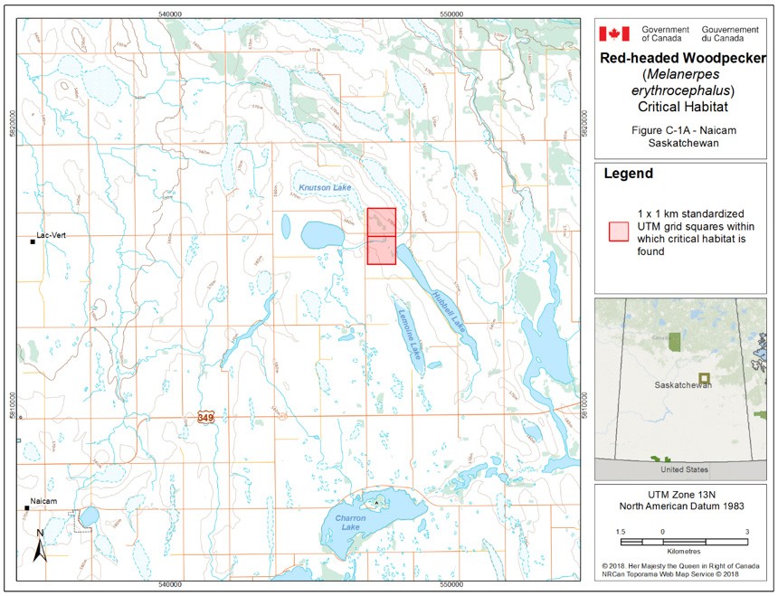
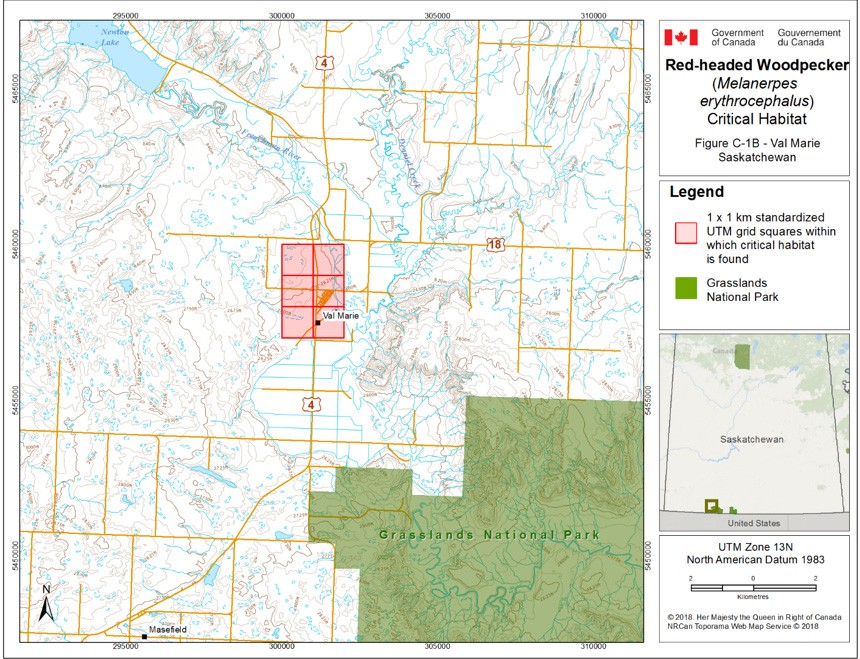
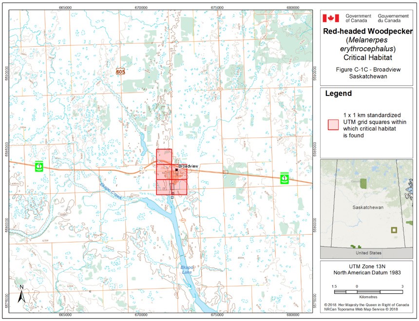
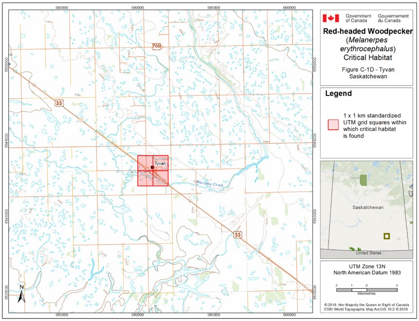

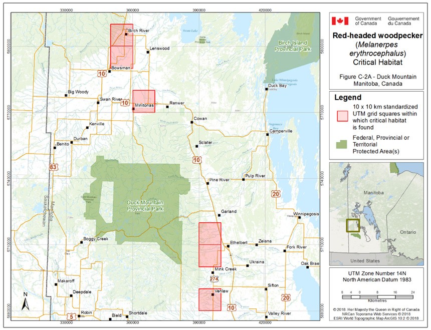
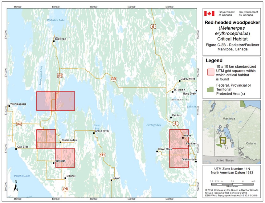
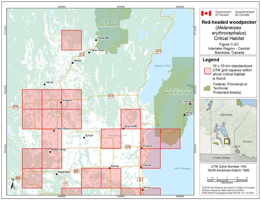
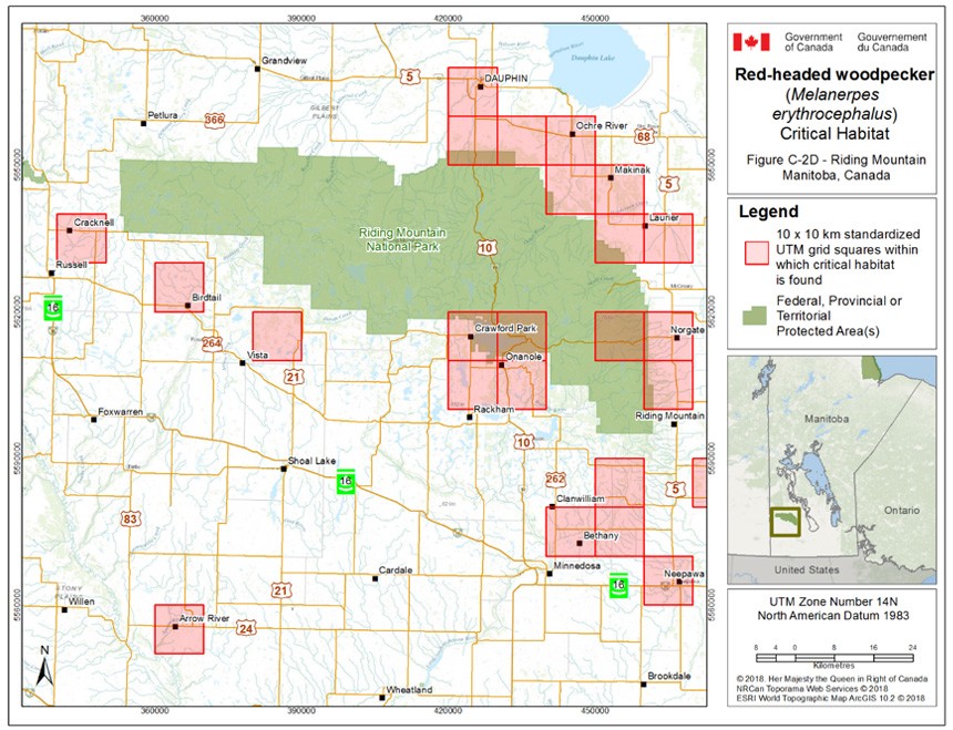
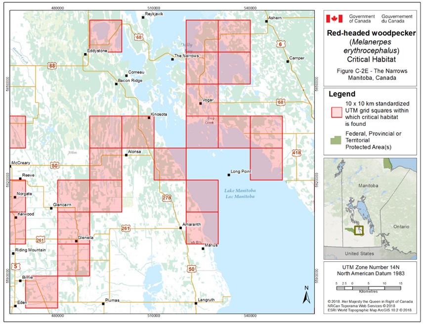
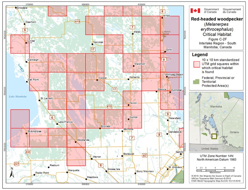
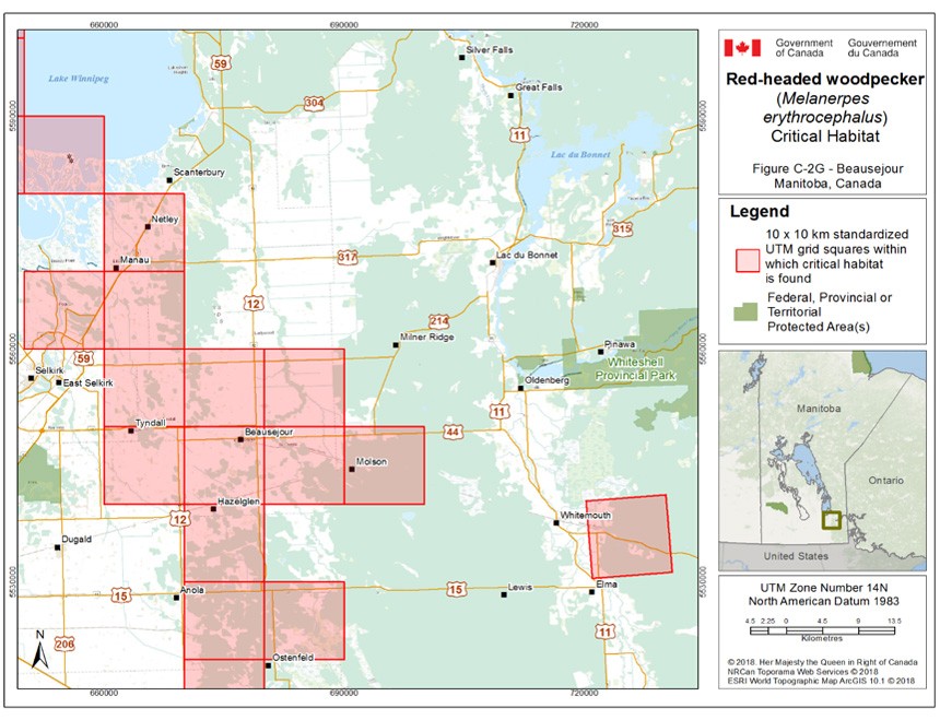
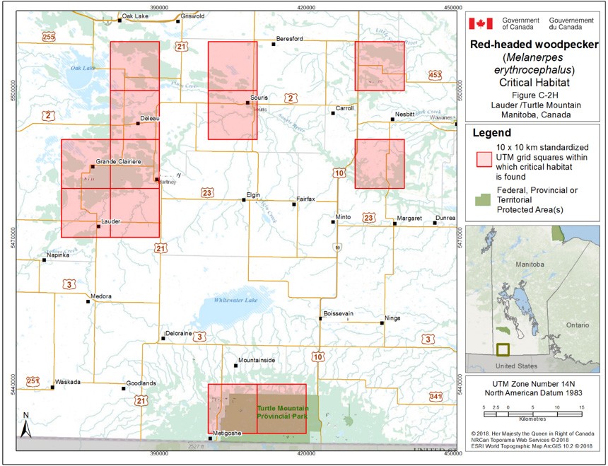
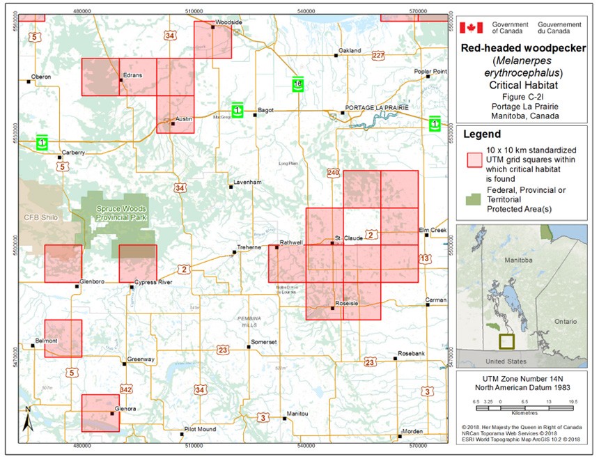
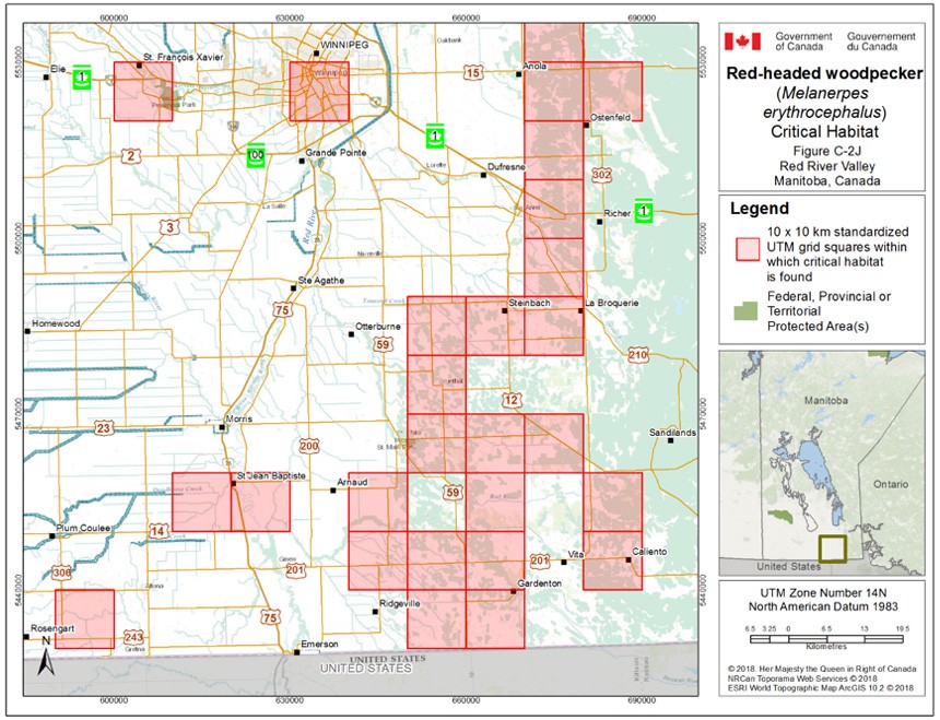
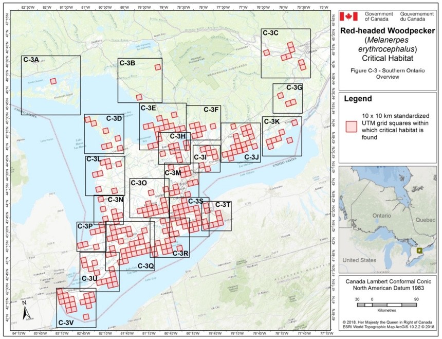
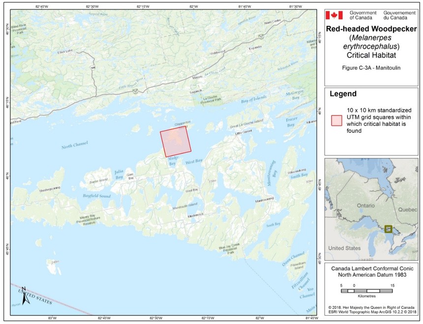
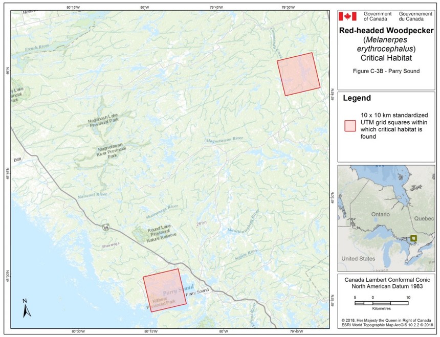
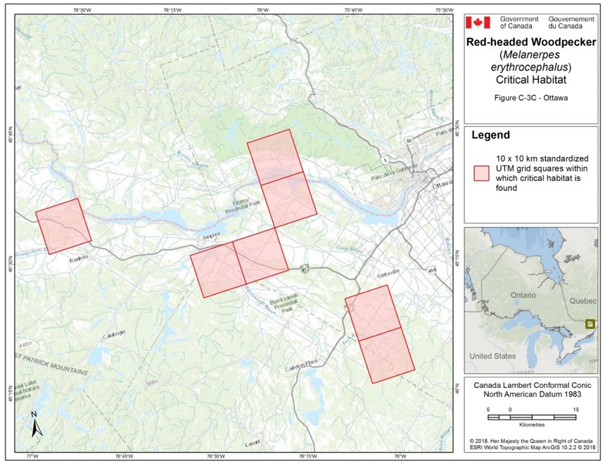
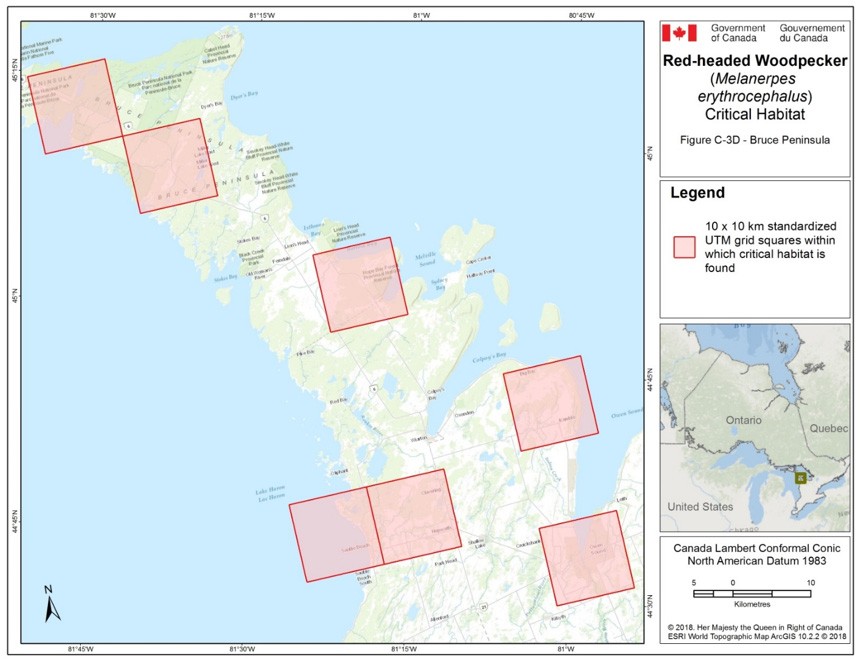
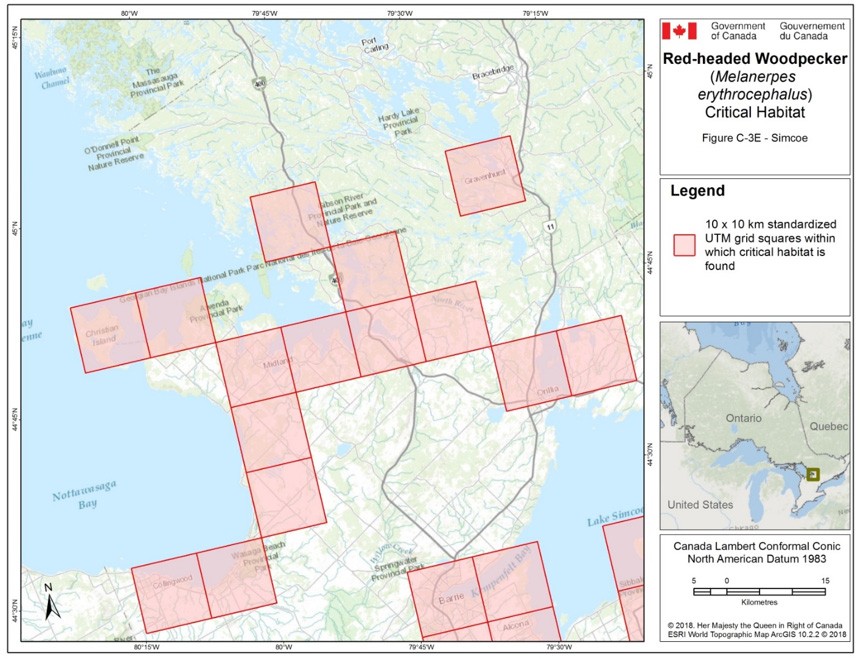
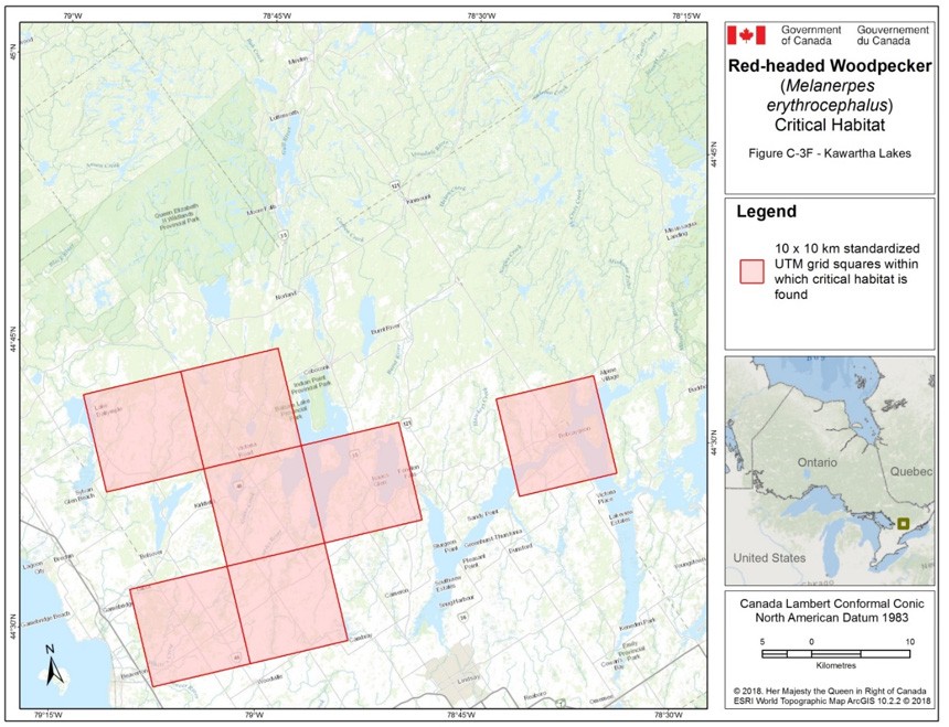
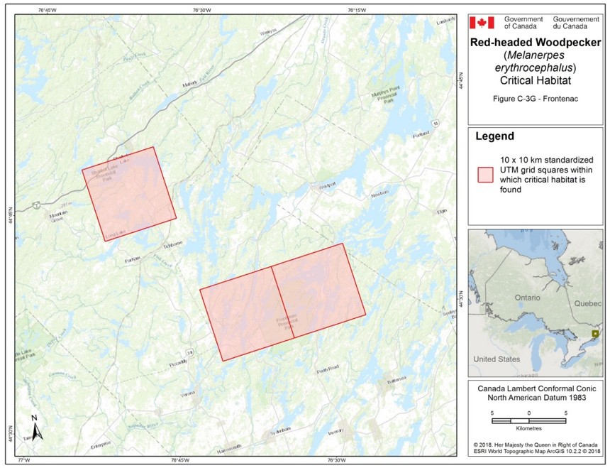
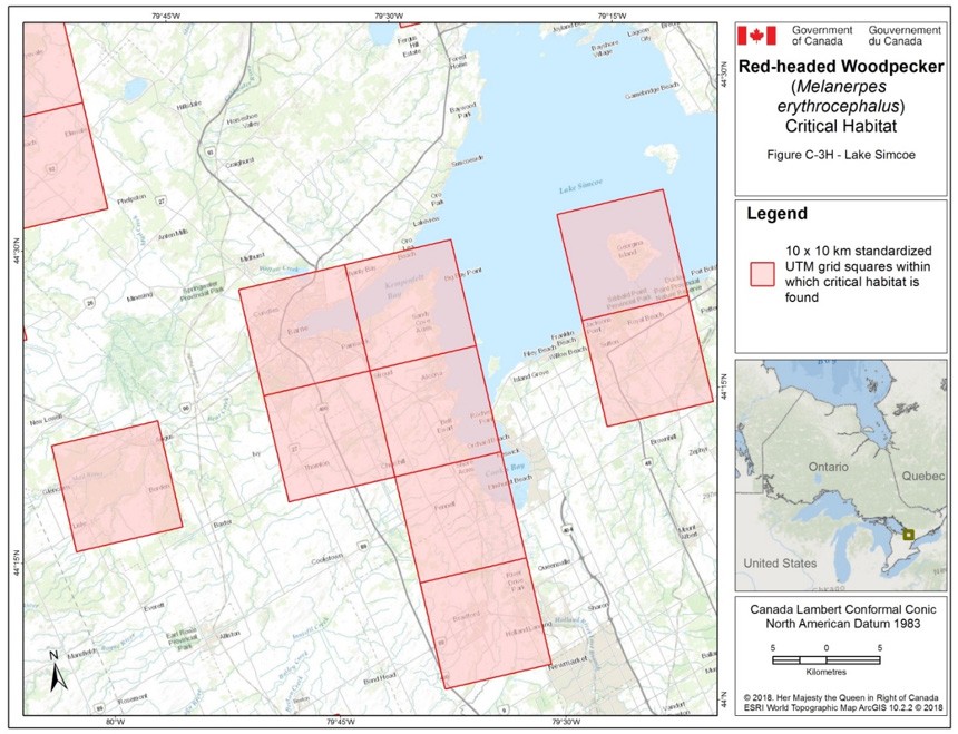
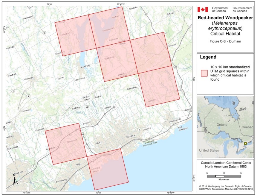
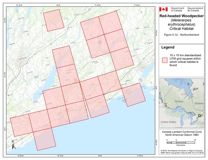
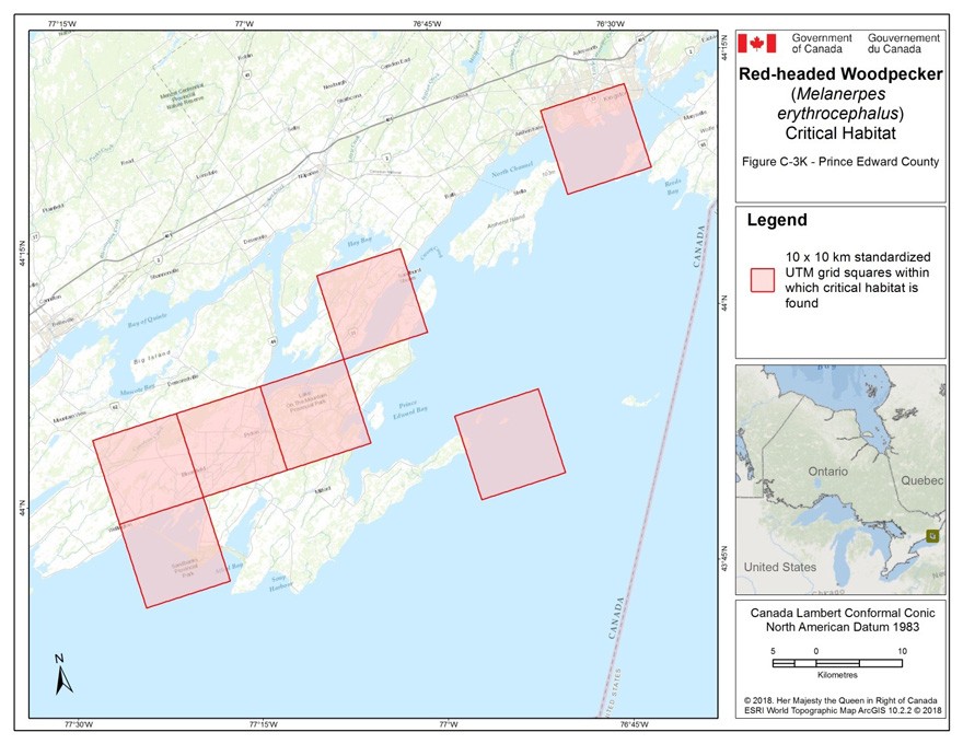
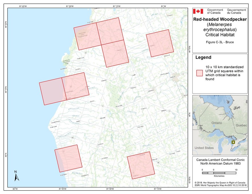

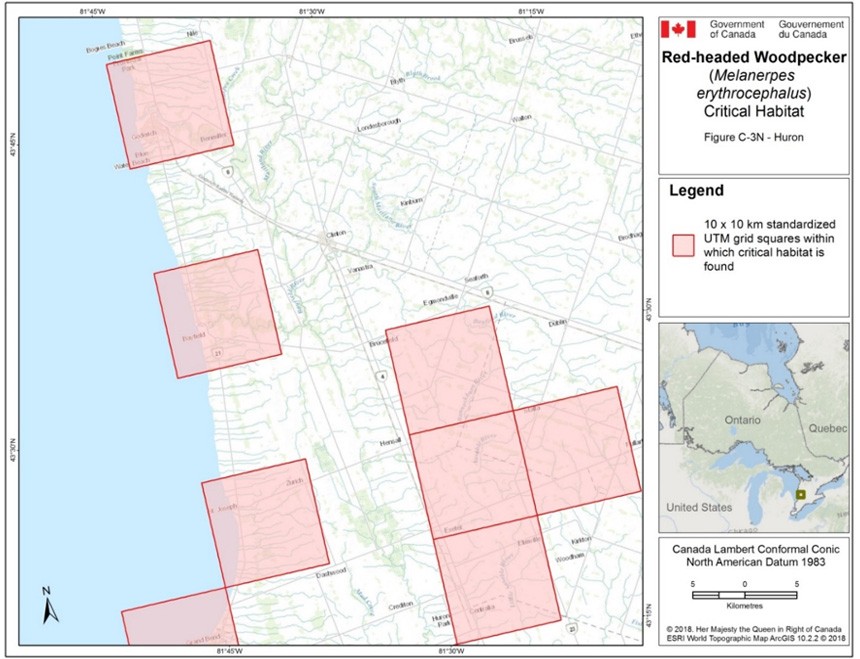
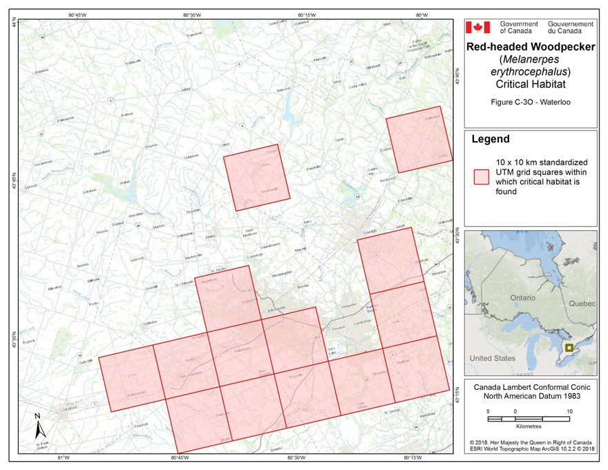

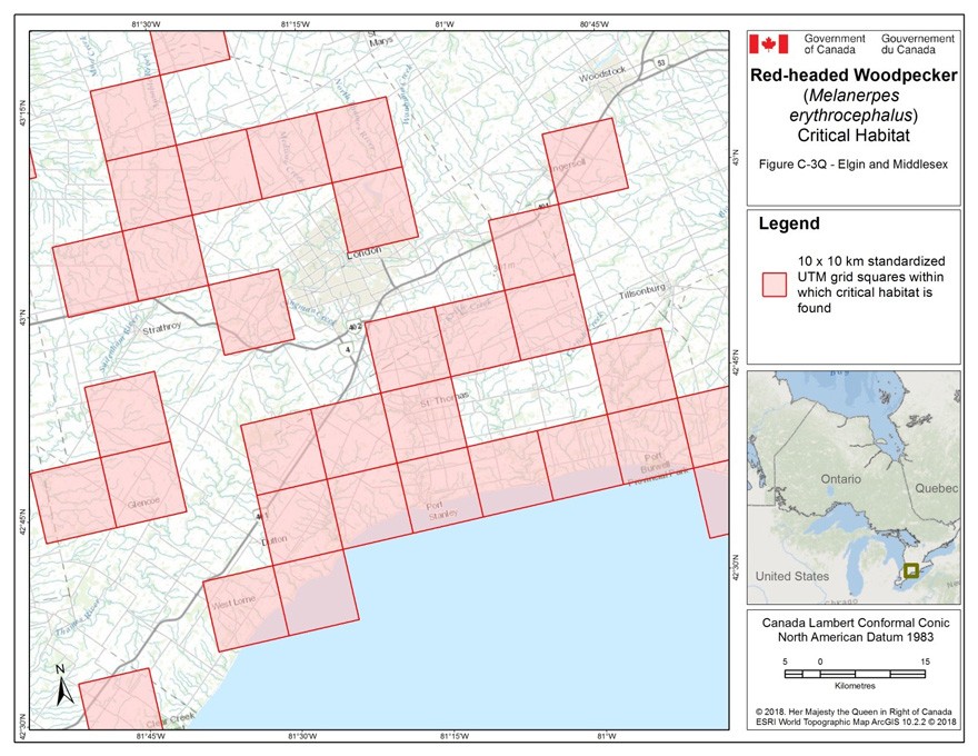
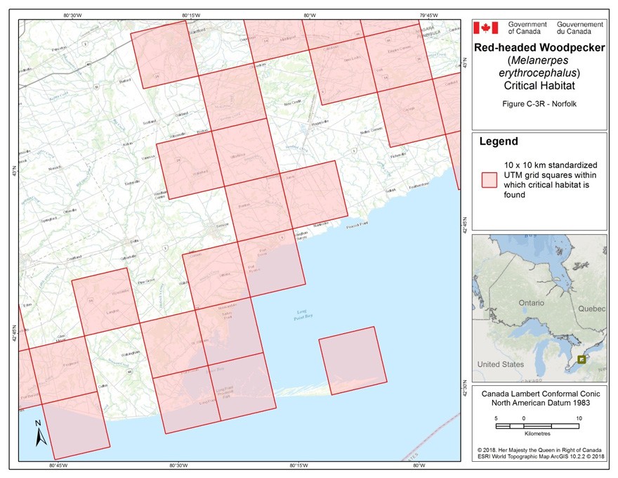
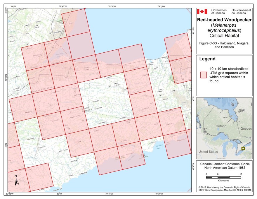
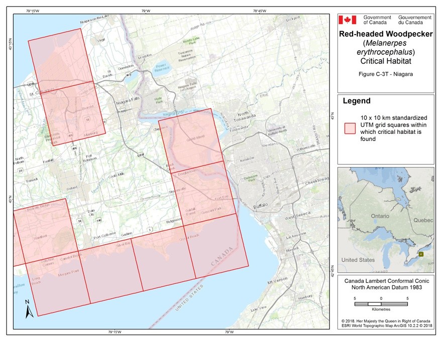
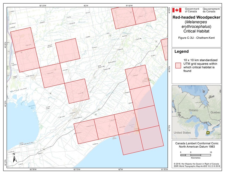
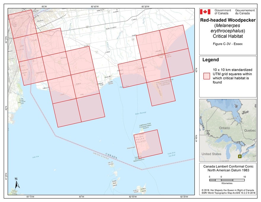
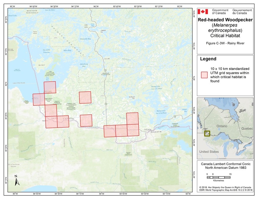
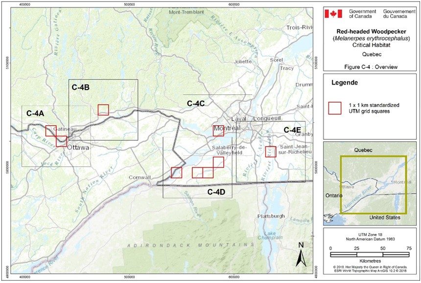
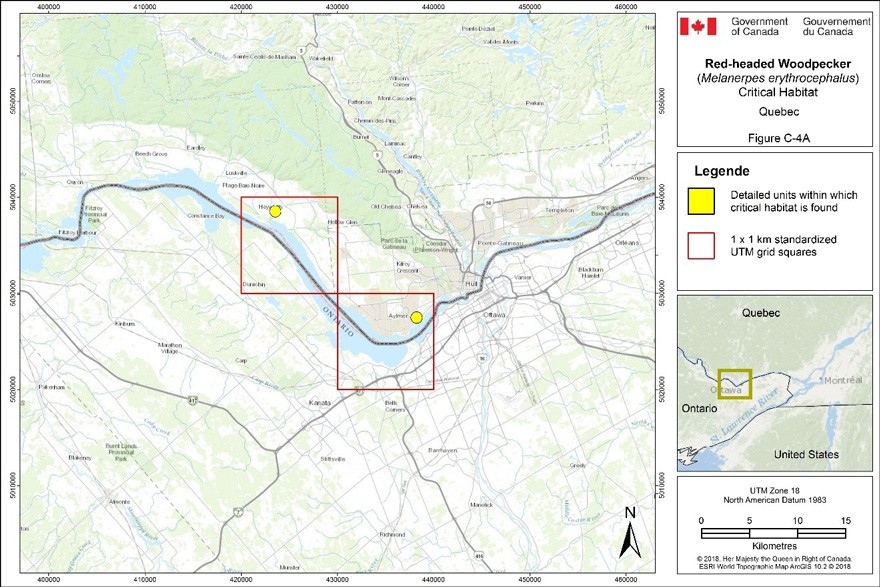
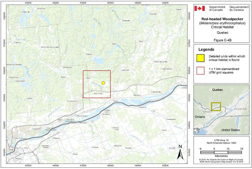
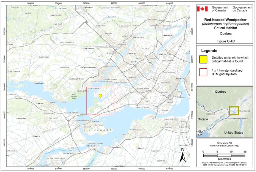
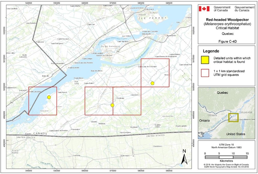
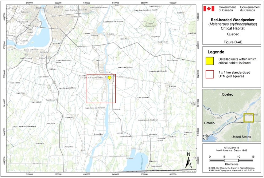
Appendix D: Threats of unknown or negligible impact to the Red-headed Woodpecker in Canada
Threat 1.2 Commercial and industrial areas
The effects associated with commercial and industrial development mirror those associated with residential development (see discussion of IUCN threat 1.1: Housing & Urban Areas in section 4), though the scope is expected to be smaller, resulting in a negligible calculated impact to the Red-headed Woodpecker in Canada.
Threat 1.3 Tourism and recreation areas
Clearing for recreational development purposes (e.g. city parks, golf courses) accounts for less than 2% of forest clearing occurring in Canada. Assessing whether this development sector has a negative impact on the species is not straightforward. Red-headed Woodpeckers have been documented nesting in large city parks if decadent trees were present, though the density of dead trees was much lower compared to forest preserves (Anderson and LaMontagne 2015). The species is also known to nest on golf courses (Peck and James 1983; Santiago 2004; Hudson and Bollinger 2013), and Rodewald et al. (2005) and Hudson and Bollinger (2013) found similar nest success rates on and off golf courses.
Threat 2.2 Wood and pulp plantations
The creation of conifer tree plantations can eliminate the open habitat used by the Red-headed Woodpecker in Canada, while not contributing suitable nesting sites.
Threat 3.1 Oil and gas drilling
In western Canada, most of the crude oil production occurs outside of the Red-headed Woodpecker’s range (CAPP 2015b). Oil and gas drilling is therefore considered to affect less than 10% of the Red-headed Woodpecker’s breeding range in the Prairies and is unlikely to increase in the future.
The Ontario oil and gas industry occurs within the Red-headed Woodpecker range in the sedimentary rocks in the south of the province. The operation of existing pumps does not affect the species, but land clearing associated with the construction of new pumps could remove decadent trees.
Threat 3.2 Mining and quarrying
The severity of mining and quarrying is extreme because when those activities are undertaken, they completely eliminate the habitat that occurred within the footprint of the licence. However, the scope of this threat is expected to be negligible.
Southern Ontario produces sand, gravel, and stone from aggregate pits and quarries in 1.1% of the species’ Ontario range (i.e. Ecoregions 5S, 6E and 7E) is under aggregate extraction (OMNR 2012). In Saskatchewan, there are no known species occurrences near the four active potash mines in the south, or near mines that may be operational in the next 10 years. In southern Manitoba the area under active or approved permits for sand, gravel, and stone from aggregate pits covers just over 2000 ha (or 0.01%) of the species range (Government of Manitoba 2017).
Threat 3.3 Renewable energy
Wind farms
A post-construction monitoring report analysis of 43 wind farms across Canada found that collisions with wind turbines are unlikely to affect most bird species at the national population level (Zimmerling et al. 2013). Post-construction mortality surveys identified 1297 individual birds of 140 species, none of which were Red-headed Woodpecker (Zimmerling, pers. comm. 2016). In Saskatchewan, Manitoba, Ontario and Quebec, 13% of turbines were located in areas that could be considered Red-headed Woodpecker habitat (i.e. deciduous or mixed woodland habitat), though not all of these were necessarily located within the species’ range (Zimmerling et al. 2013). Based on this analysis, the impact of this threat appears to currently be negligible. However, the number of wind turbines in Canada is expected to increase tenfold over the next 10-15 years and it is likely that bird mortality will increase accordingly (Zimmerling et al. 2013).
Nest destruction during turbine construction is another potential threat, though this is likely negligible for the species. Most wind farms aren’t constructed in woodlands and construction typically takes place outside of the breeding bird season (Zimmerling et al. 2013).
Wind turbine construction results in permanent habitat loss, however this threat is negligible for the species. As of 2011, 0.096% of Ontario deciduous forest and 0.082% of mixed forest in Quebec were lost to wind farms (Zimmerling et al. 2013). However, there were insufficient data to assess avoidance of areas with turbines for use as nesting, foraging or roosting habitat (Zimmerling et al. 2013).
Threat 4.2 Utility and service lines
Transmission lines
The impact on the species of collisions with transmission lines is unknown. In Canada, it is estimated that 2.5-25.6 million birds are killed annually in collisions with transmission lines (Rioux et al. 2013). However, this study looked at medium and large sized birds, so the findings may not be applicable to small birds such as the Red-headed Woodpecker. This study also assumed that small birds are less vulnerable to collisions due to better maneuverability which is not consistent with findings on collisions with communications towers (see below). Power line expansion in Saskatchewan and Manitoba is not expected to be significant in the coming years (SaskPower 2017; Manitoba Hydro 2017). Within the species’ Ontario range, one new 230kV transmission line on a new 13 km corridor has been approved for construction in the Leamington area (Hydro One Networks 2016).
Communication towers
A review of data collected in the eastern U.S. and southern Canada, found that the proportion of a bird population killed in collisions with communication towers varied greatly by species (Longcore et al. 2013). The study area which almost exactly covered the Red-headed Woodpecker’s North American range, estimated this annual mortality to be less than 1% of its total North American population (Longcore et al. 2013). Collisions occur most frequently during nocturnal migration, which may explain in part why communication towers present a relatively low threat to Red-headed Woodpeckers, which are thought to be daytime migrants in the fall and nighttime migrants in the spring (Graber and Graber 1977) when tower mortality is highest (Longcore et al. 2013).
Telephone poles
Chemical exposure of eggs laid in nests excavated in telephone poles likely poses a minimal threat to the species. A 100% mortality rate was reported among Red-headed Woodpecker hatchlings born in nests excavated in 3- to 4-yr-old creosote-treated telephone poles (Rumsey 1970). Though the proportion of Red-headed Woodpecker nests that fail due to chemical exposure to creosote is unknown, Sandilands (2010) reports only occasional use of utility poles for nesting by the species.
Threat 6.1 Recreational activities
Jackson (1976) observed that Red-headed Woodpeckers were easily disturbed by humans. In general, birds may abandon their nest if they are disturbed prior to egg-laying (Martin and Geupel 1993). Such disturbance could occur when birders or photographers are looking for nests, making repetitive use of playback calls, or standing within a few meters of a nesting tree. The extent of nest failure due to human disturbance is currently unknown for the Red-headed Woodpecker.
Threat 8.2 Problematic native species
Kilgo and Vukovich (2012) found that predation by Accipiter hawks accounted for the majority of adult Red-headed Woodpecker mortalities in a South Carolina study. Using North American bird abundance data, Koenig et al. (2017) found that the increase in abundance of Cooper’s (A. cooperii) and Sharp-shinned Hawks (A. striatus) between 1960 and 2014 was significantly correlated with decreasing abundance of Red-headed Woodpecker. This suggests that hawk predation may be a proximate driver of the Red-headed Woodpecker decline. However Koenig et al. (2017) also found a positive correlation between Accipiter hawk abundance and increased winter temperatures as well as with increased forest cover, suggesting that climate change and land-use may be the ultimate drivers behind this threat.
Threat 9.3 Agriculture and forestry effluents
Agricultural insecticides
There is potential for pesticides to have direct impacts on Red-headed Woodpeckers, although the severity of this threat is unknown. For example, neonicotinoids may be a threat to granivorous bird species that eat treated seed (Gibbons et al. 2015). While Red-headed Woodpeckers in Canada do eat seeds of plant species at certain times of the year, there is no evidence that they forage on planted seed in farm fields during the spring when such seeds are available.
Threat 11.1 Habitat shifting and alteration
There is currently no evidence to suggest that the species is directly threatened by climate change or severe weather. However, weather extremes are expected to occur more frequently as a result of climate change (Huber and Gulledge 2011), which could lead to changes in insect food availability (Both and Visser 2001). Short-distance migrants such as Red-headed Woodpecker may be better able to respond to climate change than long-distance migratory bird species because in a given year, climatic conditions on their wintering grounds will be a better predictor of spring temperatures on their breeding grounds (Both and Visser 2001). This may allow the Red-headed Woodpeckers to adjust their arrival date on Canadian breeding grounds in order to capitalize on peaks in insect abundance, as most Canadian breeders migrate from relatively close wintering grounds in temperate regions of the U.S.
An overall warming on the prairies is expected to cause a northward retraction of the Aspen Parkland (Vandall et al. 2006) and greater climate extremes may also increase flood occurrence (Sauchyn et al. 2008). This will impact woodland habitat availability and suitability in the Aspen Parkland.
Finally, increased winter temperatures in North America may be benefiting Cooper’s (Accipiter cooperii) and Sharp-shinned Hawks (A. striatus) (Koenig et al. 2017), indirectly increasing predation pressure on the Red-headed Woodpecker population (see threat 8.2).
Appendix E: Effects on the environment and other species
A strategic environmental assessment (SEA) is conducted on all SARA recovery planning documents, in accordance with the Cabinet Directive on the Environmental Assessment of Policy, Plan and Program Proposals. The purpose of a SEA is to incorporate environmental considerations into the development of public policies, plans, and program proposals to support environmentally sound decision-making and to evaluate whether the outcomes of a recovery planning document could affect any component of the environment or any of the Federal Sustainable Development Strategy’s (FSDS) goals and targets.
The possibility that the present recovery strategy inadvertently generates negative effects on the environment and on other species was considered. The recommended actions include well established habitat stewardship activities, threat severity assessments, and public outreach initiatives. We conclude that the present recovery strategy is unlikely to produce significant negative effects.
Recovery planning is intended to benefit species at risk and biodiversity in general. However, it is recognized that strategies may also inadvertently lead to environmental effects beyond the intended benefits. The planning process based on national guidelines directly incorporates consideration of all environmental effects, with a particular focus on possible impacts upon non-target species or habitats. The results of the SEA are incorporated directly into the strategy itself, but are also summarized below in this statement.
All species that depend on aerial insects for prey and/or that share similar habitat needs, such as bats, swallows, and specifically, bird species at risk including: Chimney Swift (Chaetura pelagica), Common Nighthawk (Cordeiles minor), Golden-winged Warbler (Vermivora chrysoptera) and Olive-sided Flycatcher (Contopus cooperi) and Prothonotary Warbler (Protonotaria citrea) may benefit from the recommended approaches for Red-headed Woodpecker, namely by increasing the availability of insects in open treed habitats.
Red-headed Woodpecker habitat is shared by many other species including other species at risk. Recovery activities that protect open deciduous forests (particularly those dominated by oak and beech) and other sparsely treed habitats, as well as activities that promote the retention and supply of decadent trees and nesting cavities, will positively affect a number of other species requiring similar habitat. The Red‑headed Woodpecker is a primary excavating species and its old cavities are used by other species for nesting (COSEWIC 2007). Their winter habit of caching large quantities of mast in hardwood forests is also an important dispersal mechanism for certain tree species (COSEWIC 2007). As such, protecting habitat for this species will benefit many secondary cavity-dwelling animal species as well as tree species.
| Common Name | Scientific Name | SARA Status |
|---|---|---|
| American Beech | Fagus grandifolia | Not applicable |
| Barred Owl | Strix varia | Not applicable |
| Chimney Swift | Chaetura pelagica | Threatened |
| Common Nighthawk | Cordeiles minor | Threatened |
| Downy Woodpecker | Picoides pubescens | Not applicable |
| Golden-winged Warbler | Vermivora chrysoptera | Threatened |
| Great-crested Flycatcher | Myiarchus crinitus | Not applicable |
| Hairy Woodpecker | Picoides villosus | Not applicable |
| House Wren | Troglodytes aedon | Not applicable |
| Northern Saw-whet Owl | Aegolius acadicus | Not applicable |
| Olive-sided Flycatcher | Contopus cooperi | Threatened |
| Prothonotary Warbler | Protonotaria citrea | Endangered |
| Red-bellied Woodpecker | Melanerpes carolinus | Not applicable |
| Southern Flying Squirrel | Glaucomys volans | Not applicable |
| Tree Swallow | Tachycineta bicolor | Not applicable |
| Tufted Titmouse | Baeolophus bicolor | Not applicable |
| White-breasted Nuthatch | Sitta carolinensis | Not applicable |
While some of the proposed recovery activities will benefit the environment in general and are expected to positively affect other sympatric native species, there could be consequences to those species whose requirements differ from those of the Red‑headed Woodpecker. Consequently, it is important that habitat management activities for the Red-headed Woodpecker be considered from an ecosystem perspective through the development, with input from responsible jurisdictions, of multi‑species plans, ecosystem-based recovery programs or area management plans that take into account the needs of multiple species, including other species at risk. Many of the stewardship and habitat improvement activities to benefit the Red-headed Woodpecker will be implemented through ecosystem-based conservation programs that have already taken into account the needs of other species at risk.
Footnotes
- footnote[i] Back to paragraph Dead standing trees.
- footnote[ii] Back to paragraph Trees that produce edible seeds and fruit.
- footnote[1] Back to paragraph These federally protected areas are: a national park of Canada named and described in Schedule 1 to the Canada National Parks Act, The Rouge National Park established by the Rouge National Urban Park Act, a marine protected area under the Oceans Act, a migratory bird sanctuary under the Migratory Birds Convention Act, 1994 or a national wildlife area under the Canada Wildlife Act see ss. 58(2) of SARA.
- footnote[2] Back to paragraph Decadent trees include dead trees, snags, dying trees, and trees with one or more large dead or dying limbs.
- footnote[3] Back to paragraph The United Nations defines afforestation as the establishment of trees on land that has not had forest on it for more than 50 years (Zomer et al. 2008).
- footnote[5] Back to paragraph A wildlife species that is likely to become an endangered species if nothing is done to reverse the factors leading to its extirpation or extinction.
- footnote[4] Back to paragraph Likely to become endangered or because of low or declining numbers in Manitoba, particularly at risk if the factors affecting its vulnerability do not become reversed.
- footnote[6] Back to paragraph A species that lives in the wild in Ontario, is not endangered or threatened, but may become threatened or endangered because of a combination of biological characteristics and identified threats.
- footnote[7] Back to paragraph Any species occurring infrequently and unpredictably in Alberta, i.e., outside its usual range (Government of Alberta 2011).
- footnote[8] Back to paragraph Credible intervals (CI) indicate the range of population trends, given the model used to estimate the trends and the variability in the population data; these 95% credible intervals indicate a 95% probability that the true population trend is between the upper and lower limits provided.
- footnote[9] Back to paragraph The most southern ecozone in Canada, covering all of southwestern Ontario and stretching east and north along the Saint Lawrence River to Québec City.
- footnote[10] Back to paragraph Farmland planted with annual or perennial crops, excluding pasture.
- footnote[11] Back to paragraph Standing dead trees.
- footnote[12] Back to paragraph Hard mast refers to the fruit of oak trees (acorns), beech trees (beechnuts), and other nut-producing trees consumed as food by animals.
- footnote[13] Back to paragraph A temporary, relatively sudden increase in the availability of snags in a particular area.
- footnote[14] Back to paragraph A population that does not require human intervention for long-term persistence.
- footnote[15] Back to paragraph Currently measured using the extent of occurrence (EOO), i.e. the area included in a polygon without concave angles that encompasses the geographic distribution of all known populations of a wildlife species (COSEWIC 2015). As Red-headed Woodpecker is wide-ranging with some disjunct local populations, EOO may not be a suitable measure of distribution for this species in all parts of its Canadian range. An action that aims to identify a quantitative baseline against which to measure changes in the species’ range has been included in the Recovery Planning Table (Table 4).
- footnote[16] Back to paragraph Area of occupancy is a biological measure of the occupied habitat within a wildlife species’ range.
- footnote[17] Back to paragraph Project NestWatch is a nest monitoring program administered by Bird Studies Canada.
- footnote[18] Back to paragraph eBird is a real-time, online, user-submitted checklist program that documents the presence and absence of birds, and bird abundance (eBird 2015).
- footnote[19] Back to paragraph A map of Bird Conservation Regions is available.
- footnote[20] Back to paragraph Predicted dates of first egg and nest departure dates are based on mean annual temperature of Ecodistricts and nesting data from the Project NestWatch database. The start of the breeding period is identified as the date when 10% of first eggs have been laid and the end date identified as the date when 90% of nests have been left by fledglings (Rousseu and Drolet 2017).
- footnote[21] Back to paragraph Breeding evidence categories are defined in Appendix B.
- footnote[22] Back to paragraph This distance was used to identify observations that likely represent a single territory. The 600 m distance is based on 200 m to account for the maximum likely distance between the observer and the bird, plus 10 m to account for location accuracy of observer, plus 380 m to include the diameter of the territory, plus 10 m to include a potential nest/roost tree’s dripline. It also incorporates the reported maximum territory size for Red-headed Woodpecker (see Footnote 23).
- footnote[23] Back to paragraph Territory size is defined as an area of 11.4 hectares (radius of 190 m). This number represents the maximum territory size of a breeding pair of Red-headed Woodpecker found in the scientific literature (Kilgo and Vukovich 2012).
- footnote[24] Back to paragraph A separation of one week follows atlas methodology used to presume an occupied territory (Cadman et al. 2007, AONQ 2016, MBBA 2016).
- footnote[25] Back to paragraph Observations identified as “possible breeding” were not included if they were recorded outside the species’ known breeding range.
- footnote[26] Back to paragraph The wintering period start and end dates correspond to the estimated end of the autumn migration period and the estimated beginning of the spring migration period, respectively, and is based on eBird (2015) data as well as migration calendar dates from Birds of North America Online (Frei et al. 2015a).
- footnote[27] Back to paragraph Five weeks was chosen as a separation between winter observations to ensure that the observations represented continued use of the habitat throughout a given season.
- footnote[28] Back to paragraph Territory size is defined as an area of 11.4 hectares (radius of 190 m). This number represents the maximum territory size of a breeding pair of Red-headed Woodpecker found in the scientific literature (Kilgo and Vukovich 2012).
- footnote[29] Back to paragraph In the absence of specific information on territory size in Ontario during the wintering season, a precautionary approach was applied in using the breeding season territory size.
- footnote[30] Back to paragraph Smallest documented nesting limb diameter (Jackson 1976).
- footnote[31] Back to paragraph The area beneath a tree defined by the outermost circumference of the tree’s canopy where water drips from the tree’s limbs/branches onto the ground.
- footnote[32] Back to paragraph Minimum 10% tree cover.
- footnote[33] Back to paragraph Mixed forests being those with at least 25% coniferous trees and 25% deciduous trees in canopy cover.
- footnote[34] Back to paragraph The non-built-up areas within 50 m of decadent trees and treed areas are identified as critical habitat to include non-treed features that support the Red-headed Woodpecker’s life processes, including foraging activities, adjacent to decadent trees and treed areas. Skinner (1928) noted that the Red-headed Woodpecker will sally for insects up to 50 m from a perch.
- footnote[35] Back to paragraph Given the limited distribution of Red-headed Woodpeckers and their habitat in Saskatchewan, a 1 x 1 km UTM grid is used to present the areas containing critical habitat in that province.
- footnote[36] Back to paragraph Currently measured using the extent of occurrence (EOO), i.e. the area included in a polygon without concave angles that encompasses the geographic distribution of all known populations of a wildlife species (COSEWIC 2015). As Red-headed Woodpecker is wide-ranging with some disjunct local populations, EOO may not be a suitable measure of distribution for this species in all parts of its Canadian range. An action that aims to identify a quantitative baseline against which to measure changes in the species’ range has been included in the Recovery Planning Table (Table 4).
- footnote[37] Back to paragraph Adapted from Cadman et al. 2007 and AONQ 2016.