Road allowances, dedicated roads and Crown shoreline reserves - Disposition - procedure
This procedure provides direction to ministry staff and informs municipalities and the public about the ministry's approach to the disposition of Crown shoreline reserves, road allowances and dedicated roads on Crown land under the ministry’s jurisdiction.
- Subject: Road Allowances, Dedicated Roads and Crown Shoreline Reserves – Disposition
- Procedure: PL 4.11.03
- Compiled by – Branch: Lands & Waters
- Section: Land Management
- Date Issued: March 31, 2009
- Replaces Directive Title: Road Allowances and Crown Shoreline Reserves - Disposition
- Number: Same number
- Dated: February 26, 2003
1.0 Program guidelines
1.1 Purpose
This procedure provides direction for the implementation of Policy PL 4.11.03 – Road Allowances, Dedicated Roads and Crown Shoreline Reserves – Disposition.
1.2 Procedural flexibility
A high degree of conformity to this procedure is required to ensure the application of the appropriate authority and fees in the disposition of road allowances, dedicated roads and Crown shoreline reserves. Refer to Policy PL 4.11.03 for definitions.
2.0 Procedure
2.1 Valuation
Dispositions of road allowances, dedicated roads and Crown shoreline reserves will be for the administrative fee indicated in PL 6.02.01 – Administrative Fees for Public Land Transactions or market value whichever is greater. Prior to disposition, the market value of the subject lands will be estimated to determine if it may exceed the minimum administrative fee. The market value may exceed the minimum administrative fee in situations where the addition of such lands will add significant value (i.e. value in contribution) to the adjacent upland property (e.g. ability to server new lot(s)). Examples of situations where market value may exceed the administrative fee are provided in Appendix ‘A’. The administrative fee will apply to portions of road allowances, Crown shoreline reserves and dedicated roads that front an individual lot (i.e. lot in a plan of subdivision). If the market value is estimated to exceed the administrative fee a formal valuation must be undertaken as per PL 2.03.01 – Appraisals/Valuations of Public Land.
2.2 Application
An application for a road allowance, Crown shoreline reserve or dedicated road or portion thereof must be accompanied by the following:
- A completed and signed (i.e. registered owner(s) of the adjacent/backshore parcel) Application for Crown Land (Form 830) ;
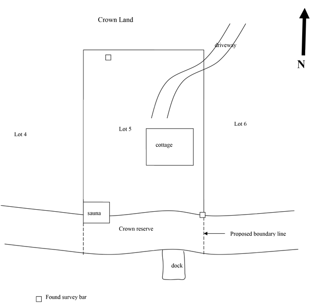
A sketch of the lands being applied for showing:
- the location of the known survey monuments of the upland parcel;
- the proposed location of the extension of the side lot lines of the backshore parcel to the waterfront boundary;
- any and all encroachments (e.g. buildings) onto the lands being applied for.
The applicant will be required to mark all found survey monuments and the proposed boundaries on the ground with orange flagging tape and/or paint to facilitate an inspection by the ministry. Refer to Appendix ‘B’ for a sample sketch;
- Proof of ownership of the backshore parcel (e.g. current copy of parcel Property Identification Number (PIN));
- Documentation of the adjacent landowners comments regarding the proposed location of the boundaries of the lands being applied for. This may be in the form of a letter addressed to the ministry from the adjacent land owner(s).
2.3 Disposition processes
2.3.1 Road allowances and dedicated roads in unincorporated territory
| Responsibility | Action |
|---|---|
| District |
|
| District |
|
| District |
|
| District |
|
| District |
|
| District |
|
| Land Management Section |
|
| Land Management Section |
|
| Land Management Section |
|
| District |
|
2.3.2 Crown shoreline reserves
| Responsibility | Action |
|---|---|
| District |
|
| District |
|
| District |
|
| District |
|
| District |
|
| District |
|
| Land Management Section |
|
| Land Management Section |
|
| District |
|
3.0 References
3.1 Legislative cross references
- Public Lands Act – Section 16
- Public Lands Act – Section 55.1(1), (3)
3.2 Directive cross references
- PL 2.03.01 – Appraisals/Evaluations of Public Land Policy and Procedure
- PL 2.05.01 – Survey Plan Approval Policy and Procedure
- PL 4.02.01 – Application Review and Land Disposition Process Policy and Procedure
- PL 4.02.02 – Obtaining Minister’s Orders Procedure
- PL 4.11.03 – Road Allowances, Dedicated Roads and Crown Shoreline Reserves Policy
- MNR Class Environmental Assessment for Resources Stewardship and Facility Development Projects
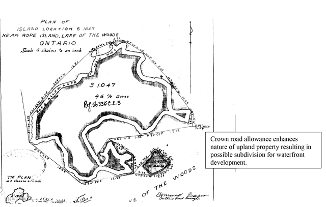
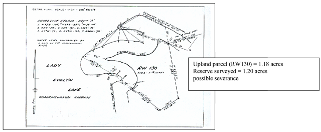
Appendix ‘A’: Examples of potential value-added by disposition of road allowance or Crown shoreline reserve
Crown road allowance enhances nature of upland property resulting in possible subdivision for waterfront development.
Upland parcel (RW130) = 1.18 acres Reserve surveyed = 1.20 acres possible severance
Appendix ‘B’: Sample application sketch