Short Hills Provincial Park Management Plan
This document provides policy direction for the protection, development and management of Short Hills Provincial Park and its resources.
© 1991, Queen’s Printer for Ontario
Additional copies of this publication are obtainable from:
Ministry of Natural Resources
Highway 20, P.O. Box 1070
Fontbill, Ontario L0S lE0
416-892-2656
ISBN 0-7729-8964-8
Note: This document has been scanned and formatted, and therefore is slightly different from the original version. -March 2002
Twinleaf
Jeffersonia diphylla
By Zile Zichmanis
Twinleaf is a plant of rich forests and is restricted to the southerly portions of Ontario. In May the rich white blossoms rise from among elegant, symmetrical leaves.
We are pleased to approve the Short Hills Provincial Park Management Plan, as official policy for the protection, management and development of this park. The plan reflects this Ministry’s intent to protect the natural and cultural features of Short Hills Provincial Park and maintain and develop high quality opportunities for outdoor recreation and heritage appreciation for both residents of Ontario and visitors to the Province.
Signed by:
K. Vogan
Regional Director
Central Region
N.R. Richards
Director, Provincial Parks and
Natural Heritage Policy Branch
Summary
Short Hills Provincial Park is a 688-hectare natural environment class park on the southwest edge of St. Catharines, in the Regional Municipality of Niagara. The park provides protection for provincially significant life science and earth science features, notably Niagara Escarpment features and Carolinian forests. Park visitors also enjoy many recreational activities including walking, cross-country skiing, fishing, horseback riding and bicycling. Appreciation of natural and cultural features also is important in the park’s objectives. Short Hills is a "nodal park" in the Niagara Escarpment Parks System.
Several adjacent properties are identified for possible acquisition as funding becomes available and if owners are willing to sell. These would better provide for recreational activities and broaden the range of natural features protected in the park.
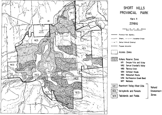
The park is divided into three types of zones: access; natural environment; and nature reserve. Three small access zones -about one percent of park area- provide parking, access to trails and, eventually, will provide toilets and educational information. Almost three quarters of the park lies within natural environment zones which protect the park’s natural and cultural features while still allowing a variety of recreational activities. Twenty-seven percent of the park area falls within seven nature reserve zones which protect the most significant natural features including portions of a re-entrant valley, bedrock exposures, waterfalls, wetlands, forests and rare Carolinian plants.
For the most part, natural processes will be allowed to govern the evolution and development of natural features in the park. A resource management plan will be developed to guide efforts to maintain and enhance fish habitat through selective erosion control while maintaining the natural values and natural processes for which the park is protected.
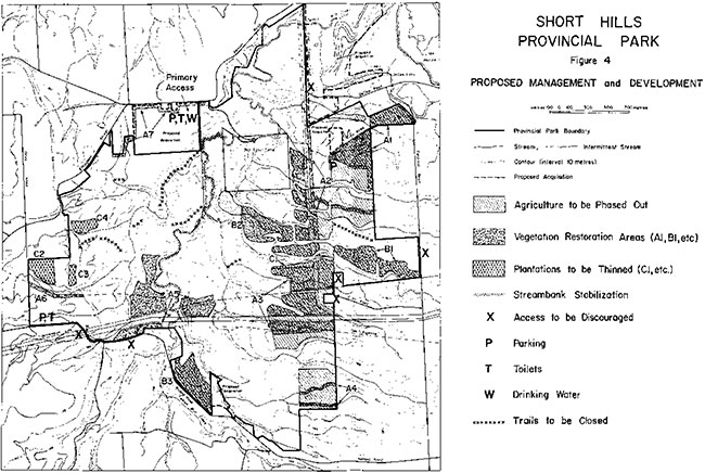
Restoration of more natural forest communities will occur on lands currently farmed and selected abandoned farm fields. One hundred and eight hectares are to be replanted. Agriculture will be phased out by the summer of 1993. Tree planting will aim to protect and rehabilitate streams, hide utility corridors in the park, delineate the park perimeter, create larger forested areas and create wildlife corridors across the park.
The status of rare species will be monitored to ensure their survival in the park. A population of Cucumber Magnolia, an endangered tree species, will be established. Establishment of populations of other selected rare species will be considered.
Heritage interpretation and education will be low-key and self-use. Themes will include: Niagara Escarpment, erosional processes, cold water stream ecology, Carolinian species, forest ecology, environmental conservation, the War of 1812, 1837 rebellion; and early settlement. Research and outdoor education will be encouraged.
Twenty-five kilometres of trails will be developed: 56% walking trails and 44% multi-use trails. Multi-use trails will accommodate walking, skiing, horseback riding and bicycling. Horseback riding and bicycling will be limited to multi-use trails and a season for horseback riding will be instituted. Snowmobiling in the park will end at the conclusion of the 1991-92 winter season.
Five walking trails will be developed: Emerald Creek Trail; Terrace Creek Trail; Scarlet Tanager Trail; Hemlock Valley Trail and Palaeozoic Path (also wheelchair accessible). Two multi-use trails will be developed: Swayze Falls Trail and Black Walnut Trail. The Bruce Trail passes through the park and will utilize portions of the Emerald Creek, Swayze Falls and Black Walnut Trails. Use of problem trails will be discouraged.
The main access point will remain at Pelham Road; secondary access points will remain at Roland Road and Wiley Road. Parking will be expanded at all three locations. Toilets will be developed near the Pelham Road and Roland Road access points when resources permit. Use of some informal access points will be discouraged after the main access points are better developed. Involvement of volunteers in park protection, development and management will be promoted.
1.0 Introduction
Southwest of St. Catharines, the clay plain of Niagara gives way to the dramatic, undulating landscape of the "Short Hills". Roads, which normally show a penchant for straightness, yield in the Short Hills to the "roller-coaster" topography.
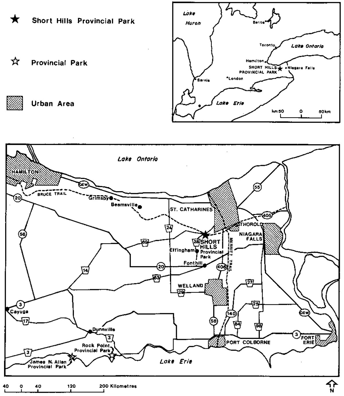
Located near the centre of the Regional Municipality of Niagara, Short Hills Provincial Park (Figure 1) protects and provides recreation on these scenic hills enveloped by field and forest.
The hills and vales of Short Hills owe their origin to an ancient reentrant valley that once cut through the Niagara escarpment and connected the basins of Lakes Ontario and Erie. Subsequently, glacial deposits buried the valley and the modern Twelve Mile Creek in turn dissected these deposits to form the "Short Hills". Numerous waterfalls cut through the glacial deposits to expose layers and layers of different bedrock strata of the Niagara Escarpment.
Hardwood tree species typify the park’s blanket of forest. Southern species, peculiar to the Carolinian Zone, such as tulip tree and sweet chestnut, are sprinkled throughout the woodlands. A host of wild blooms erupt beneath the canopy of these forests. Trilliums, hepaticas, trout lilies and dutchman’s breeches fill the spring woods with colour.
The varied topography and array of historic land uses has spawned a patchwork of field and forest, and in turn a blend of woodland and open country fauna including southern species like the mockingbird and opossum. Twelve Mile Creek, Niagara’s only cold water stream, sustains brook trout in the Short Hills.
As part of efforts to protect the natural features of the Niagara Escarpment and provide recreation associated with it, the Ontario government began acquiring land in the 1960's for a provincial park in the Short Hills area. In 1973, the Minister of Natural Resources appointed the Short Hills Provincial Park Advisory Committee to solicit public input and make recommendations regarding the proposed park.
Most of the recommendations of the 1974 Advisory Committee report were supported by the government and emphasized recreational opportunities that required a minimum level of development. This report provided the direction for the master plan for Short Hills, completed in 1977.
In 1985, the 688 hectares of Short Hills were regulated as a provincial park under the Provincial Parks Act (Regulation 45/85).
Short Hills is part of the Niagara Escarpment Parks System which protects the significant natural and cultural features along the escarpment, as well as provides for recreation and appreciation of the features. The system, when complete, will consist of over 120 parks, totalling over 45,000 hectares. These parks include lands owned and managed by a wide variety of agencies. The Bruce Trail forms an integral part of the Niagara Escarpment Parks System and links the parks together.
Short Hills has been designated a "nodal" park in the Niagara Escarpment Parks System. Nodal parks are intended to serve as key staging areas, interpretive centres for each section of the escarpment and major starting places for exploring other nearby parks.
During 1989-1991 this management plan was developed and public consultation was conducted to ensure public input into the revised plan. Following initial consultation and information gathering, a "Background Information, Issues and Options" report was issued and public comment received on the report. Based on response to that report, a Preliminary Management Plan was drafted and released for public review. This final plan is the culmination of the planning process. Section 12.0 "Summary of Public Consultation" summarizes in detail the public consultation that took place.
2.0 Summary of significant issues
Many issues were raised during the planning process. After release of a "Background Information, Issues and Options" report (see references) public comment was sought on broad issues regarding the park. The public response helped provide the direction for the "Preliminary Management Plan" (see references), also released for public review. Public comments on the preliminary plan helped set the course for changes reflected in this final management plan. The discussion below summarizes issues of concern raised during the planning process.
2.1.1 Development issues
The clearest message from the public was that they prefer Short Hills as a wild, natural area with only very basic facilities to support trail use. Consequently, only trails, expanded parking, toilets and a limited number of picnic tables are proposed (see 10.0 Development Policies). Small information display panels will assist in the interpretive or public education program (see 9.1.2 Interpretation). Trail development is the focus of development proposed in this plan.
No camping facilities will be developed in accordance with public wishes. However, provision for Bruce Trail camping is provided at Camp Wetaskiwin, the Boy Scout camp.
Three main access points to the park exist and will be maintained. Ten other informal access points exist; use of five of these will be discouraged after the main access points are better developed (see 102 Access).
2.1.2 Trail issues
Short Hills is a trail-oriented park and thus improvements to the trail system are a major issue. Poor trail design or lack of design, lack of maintenance, horse use during wet weather, horse use on extreme slopes, and all-terrain vehicle use have all contributed to trail deterioration (Figure 2). Trail deterioration has made hiking difficult on many trails used by horses. To remedy this, the public favoured designation of several walking trails and other multi-use trails. Multi-use trails would allow walking, horseback riding and mountain bicycling.
Seven major trails totalling 25 kilometres are proposed, to be developed largely from existing trails (see 10.1 Trail System). Five walking trails are proposed (Figure 5; 56% of total length of park trails). Two additional trails would be multi-use trails, accommodating walkers, horseback riders and mountain bicyclists (44% of total length of park trails). Most informal trails will remain "as is", but a few would be closed. Use of all informal trails will be discouraged.
Changes made to the proposed trails since the preliminary plan reflect concerns that walking trails should be more accessible to the Pelham Road access point. An additional walking trail, the Emerald Creek Trail, has been added to the proposals and all walking trails would now be linked so a visitor could hike without having to use multi-use trails. One multi-use trail proposed in the preliminary plan, now eliminated, was thought to be environmentally unsound.
Selective trail redesign and a trail user awareness program aimed particularly at horseback-riders will be used to prevent damage to trails by horses. Limiting horses to multi-use trails and to a riding season excluding the wettest time periods will also minimize trail damage (see 9.3.1 Horseback Riding).
The public did not favour continued use of the park by snowmobllers. Snowmobiling was not permitted in the 1977 plan, but was permitted on an interim basis in 1978 and continued after that time. Snowmobiling in the park will be ended at the conclusion of the 1991-92 winter season.
2.2.1 Resource management issues
Restoration of more natural vegetation in the park, primarily through selective tree and shrub planting, is a major proposal in this plan (see 8.2.1 Vegetation Restoration). The proposals focus on areas in the park currently being farmed and to a lesser extent on selected old fields and pine and spruce plantations. Agriculture will be phased out of the park by July 1993.
3.0 Classification
Short Hills is classified as a Natural Environment Park to reflect the provincially and regionally significant natural features present and the high quality recreational opportunities it provides. Park classification matches the park’s natural features with appropriate recreational use.
Figure 1: Regional Context
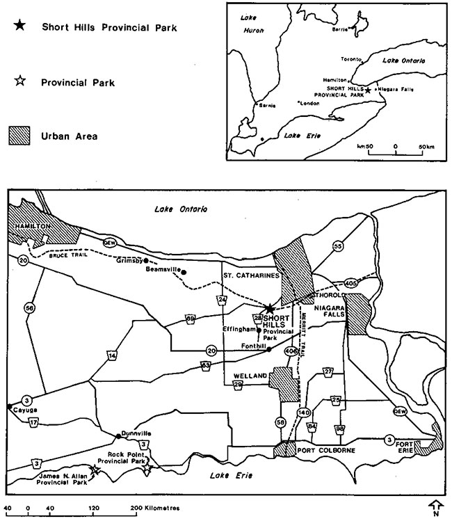
Enlarge Figure 1: Regional Context
Currently, Short Hills is designated as a "Nodal Park" within the Niagara Escarpment Parks System. Nodal parks are meant to be key staging areas for use of the escarpment and provide information on the entire Niagara Escarpment Parks System. Short Hills' nodal park designation is being reassessed under the five-year review of the Niagara Escarpment Plan that is taking place. The Ministry has recommended that the nodal park designation be retained for Short Hills.
4.0 Goal
The goal of Short Hills Provincial Park is to protect the park’s significant natural features and provide opportunities for a variety of high quality, day-use recreational and interpretive experiences. These experiences will be trail-oriented and require only minimal support facilities.
Short Hills is one of the parks of the Niagara Escarpment Parks System. The park will help achieve the goal of protection of escarpment features as well as provision of outdoor recreation, exploration, appreciation and discovery opportunities related to the escarpment. Short Hills forms part of the "core area" of the Niagara Escarpment Biosphere Reserve designated in 1990. The Biosphere Reserve is an international designation bestowed by the United Nations-sponsored Man and Biosphere program.
Few large natural parks such as Short Hills exist in the Niagara Peninsula. It is also the major park in the eastern, Niagara portion of the Carolinian zone of Ontario. As such, it will play a role in the conservation of the flora and fauna of Niagara and the Carolinian zone (see 8.0 Resource Management). The Carolinian zone is that region more-or-less southwest of a line drawn between Grand Bend and Toronto. Flora and fauna such as tulip tree, mockingbird and opossum typical of more southern climes inhabit this southern section of Ontario. A cooperative effort by government and conservation groups has sought to protect the zone’s threatened habitats.
The Ontario Provincial Parks Planning and Management Policies govern provincial parks throughout Ontario, including Short Hills. These in 1988.
In 1983, District Land Use Guidelines for Niagara were approved and set targets for all Ministry programs including provincial parks. Specific picnicking and camping targets were set for Short Hills (see 52 Recreation Objective).
5.0 Objectives
Ontario’s provincial parks system has four objectives: protection, recreation, heritage appreciation and tourism. Natural environment parks contribute to all four objectives.
Natural Environment Parks incorporate outstanding recreational landscapes with representative natural features and historical resources to provide high quality recreational and educational experiences.
5.1 Protection objective
The protection objective of the Ontario Provincial Parks System is to protect provincially significant elements of the natural and cultural landscape of Ontario.
The protection objective will be accomplished through appropriate zoning and management.
5.1.1 Earth science
Most of Short Hills lies within an ancient reentrant valley that once connected the basins of Lakes Ontario and Erie, before drainage shifted to the Niagara River. This valley is the major earth science feature the park represents in the provincial parks system. Subsequent glacial deposits have buried much of the valley and the modern Twelve Mile Creek has in turn eroded these deposits to form the "Short Hills". The many bedrock exposures within the park add further interest. Almost all the segments of the Silurian period are represented in the various outcrops of the Niagara Escarpment. The park’s numerous waterfalls expose many of these outcrops.
Within the park, the Niagara Escarpment is buried by glacial sediments. Two segments of buried escarpment lie beneath the east and west sides of the reentrant valley. An upper primary scarp is capped by Lockport dolomite while the lower, secondary scarp is topped by Irondequoit limestone.
5.1.2 Life science
Hardwood tree species dominate the park’s forests. Southern species, typical of the Carolinian Zone, such as tulip tree and sweet chestnut are sprinkled throughout the forests. The varied topography and diversity of historic land uses gives rise to the park’s complex mosaic of vegetation communities. Forest covers half of the park’s lands. The other half of the vegetation has evolved after previous farming. Old field covers 30 percent of the park, 15 percent remains under cultivation and 5 percent has been planted with pine and spruce trees.
A patchwork of field and forest as well as the juxtaposition of valley and hilltop affords a wealth of habitats for Short Hills' fauna. Forest fauna such as scarlet tanager, ovenbird and eastern wood pewee, red-backed salamander and wood frog are frequently sighted. Field species like mockingbird, meadowlark and little brown snake also abound. Well represented are white-tailed deer, wild turkey and other species of both forest and field. Niagara’s only cold water stream sustains brook trout.
Provincially and regionally significant life science features derive from the upland deciduous forests, ravine mixed forests, bottomland forests and wetlands and the associated flora and fauna. Of particular note is the southern, Carolinian component of the flora and fauna. A number of nationally, provincially and regionally significant species occur in the park, such as the nationally threatened sweet chestnut tree and the nationally rare pawpaw tree. Protection of the natural features of Short Hills will include the restoration and enhancement of native vegetation and rare and endangered species within the park (see 8.0 Resource Management Policies).
5.1.3 Cultural heritage
While some of Niagara’s important historic events have been played out in the vicinity of Short Hills, no significant historical resources number of minor archaeological sites have been identified. Early settlement focusing on streams with energy potential occurred all around Short Hills. A skirmish of the 1837 rebellion took place in the secluded valleys of the park. A plaque commemorating the battle has been erected along Holland Road. One nature reserve zone is named for Samuel Chandler one of the leaders of the local patriots. A portion of the historic settlement of Reynoldsville is located on lands proposed for acquisition (see section 6.1).
5.2 Recreation objective
The recreation objective of Ontario’s Provincial Park system is to provide day-use opportunities in areas of outstanding recreational potential associated with natural environments. Niagara Escarpment Parks provide a wide variety of escarpment-related outdoor recreation opportunities.
The Niagara District Land Use Guidelines set targets for Short Hills for picnicking and camping. A total of 76,900 picnicking opportunities were to be provided at 320 picnic tables in the park. At 10 walk-in campsites, 2,400 camping opportunities were to be provided. These targets will be revised as the proposals in this plan do not emphasize picnicking and camping opportunities. Rather, recreation facilities at Short Hills cater to trail-oriented, day users and thus only a limited number of picnic tables will be provided. No camping will be provided. Camping for Bruce Trail hikers is provided by the Boy Scout camp. These changes reflect public opinion as expressed during public consultation. The park currently provides a quiet, natural environment experience for a variety of trail users. Current uses include walking, horseback riding, sport fishing, cross country skiing, mountain biking, heritage appreciation and outdoor education. Park management must ensure the maintenance or enhancement of the quality of these experiences while increasing use to some extent, particularly in non-peak times.
The recreation objectives will be accomplished through a revitalized trail system (section 10.1) and a visitor services program (section 9.1) concentrating on self-use facilities and provision of information on the experiences available in the park.
Figure 2: Existing Development and Management
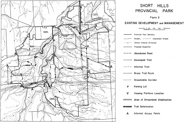
Enlarge Figure 2: Existing Development and Management
5.3 Heritage appreciation objective
Heritage appreciation focuses both on cultural heritage such as history and archaeology as well as on our natural heritage which includes species, ecosystems and landscapes. The heritage appreciation objectives of Natural Environment Parks are:
- providing opportunities for unstructured individual exploration and appreciation of the natural environment heritage of Ontario
- providing opportunities for exploration and appreciation of natural and cultural environments through interpretation and education based on the character and significance of Natural Environment Parks
The natural features of Short Hills make it ideal for these pursuits. The numerous waterfalls and sweeping panoramas provide scenic amenities. The Niagara Escarpment, reentrant valley and the related "short hills" topography provide an interesting and varied setting. The great variety of forests and open habitats support many species of flora and fauna including those of a southern, Carolinian nature. As a Niagara Escarpment Park, appreciation of the escarpment-related heritage has particular importance.
The heritage appreciation objectives will be accomplished through a visitor services program (section 9.1) concentrating on self-use facilities and provision of information on the significant features of the park.
5.4 Tourism objective
The tourism objective is to provide Ontario residents and out-of-province visitors with opportunities to discover and experience distinctive regions of the province.
Short Hills fits into a fabric of regional tourism and provides experiences not well represented in other parts of Niagara.
Many highly developed commercial tourism facilities exist in Niagara, such as Niagara Falls itself the Shaw Festival and Marineland. Short Hills provides a contrast to those sites and complements them by adding to the variety of experiences available. In this way, the park enhances regional tourism. The marketing approach for the park is outlined in section 9.4 Marketing.
6.0 Boundary
The present park boundary, for the most part, falls within the boundaries recommended by the 1974 Advisory Committee on Short Hills Provincial Park.
Camp Wetaskiwin, the Boy Scout camp, is privately-owned and not part of the park (Figure2).
Trans-Canada Pipelines holds an easement on the gas pipeline right-of-way through the park (Figure2).
Ontario Hydro holds an easement on the north-south hydro right-of-way (Figure 2), along Wiley Road and through the extreme southeastern section of the park. The east-west hydro right-of-way is owned by Ontario Hydro and the Ministry holds a 25-year lease on the lands.
The Niagara Escarpment Plan land use designations on surrounding lands provide some buffer between the park and nearby urbanized areas. Nevertheless, the surrounding area has experienced an increasing density of single-family dwellings.
6.1 Possible acquisitions
A number of parcels of land are identified as desirable for acquisition (Figure 2). Two of these properties, discussed in detail below, are high priority while the others are longer term priorities. All purchases are negotiated on a "willing seller-willing buyer" basis.
A relatively large area, adjacent to Pelham Road (Figure 2), in the north of the park will be acquired if available. Purchase would allow for better access, parking, facilities and trail configuration. Whether this property is purchased or not, the primary access point for the park will remain at Pelham Road (see 7.1.2 Pelham Road Main Access).
Another larger (67 hectares) parcel of land, east of First Street Louth (Figure 2), will be acquired if available and if funding permits. These lands have high natural heritage and recreational value. A portion of a provincially significant earth science feature, Decew Falls area, is included. A portion of historic Reynoldsville, a mill-centred community dating to the eighteenth century, occurs on the lands (see "Short Hills Provincial Park Historical Report", listed in References). If this land were purchased, the entire Twelve Mile Creek Valley downstream from the park would be in public ownership, facilitating development of a trail connector to St. Catharines (see 10.3 Links With Other Trail Systems).
Two smaller properties, one off Holland Road in the south and the other on Wiley Road (Figure 2), are of interest for acquisition in the longer term, should they become available. Other properties which become available will be evaluated in terms of how they might contribute to park objectives.
Former road allowances in the St. Catharines and Pelham portions of the park are owned by the Ministry with the exception of one in the southwest on which negotiations are continuing. Negotiations for the transfer of road allowances in the Thorold portion of the park to the Ministry are underway. These areas will be added to the area regulated as a provincial park under the Provincial Parks Act.
6.2 Boundary demarcation
The park boundary is not well-marked in many locations, most notably on the eastern edge of the park. As agriculture is phased out, fencing and signs will be added to clearly indicate the boundary. The division between the Boy Scout camp and the park is not marked and some scout camp facilities are very near the park boundary. Park visitors can easily and inadvertently end up on camp property. Similarly, scout camp visitors can easily end up on park property where appropriate activities differ from those in the camp. This boundary will be surveyed if necessary and clearly marked.
6.3 Ensuring compatible adjacent land use
The park contributes to Niagara’s ecological and recreational diversity through linkages with other natural areas and recreational facilities. The ecological values inside the park also depend on connections to adjacent habitat.
Connections to woodlands along the Niagara escarpment, in the St. John’s Valley, to the east, and downstream, along the Twelve Mile Creek valley are all important to maintaining values protected in the park.
The park’s location in the middle of the watershed of the Twelve Mile Creek makes the park’s creeks particularly vulnerable to unfavourable environmental impacts due to change in land use.
The Ministry will seek compatible adjacent land use that will maintain the ecological and recreational values in the park. Provincial input into municipal planning, fish and wildlife landowner extension services, landowner contact, Fisheries Act enforcement and other means will be used to influence adjacent land use.
6.4 Coordination with the Boy Scout Camp
The Boy Scout camp, Camp Wetaskiwin, is located near the centre of the park. The 1977 master plan indicated that an agreement would be negotiated between the Ministry and the Boy Scouts regarding the management of the camp and the park. While no formal agreement was negotiated, cooperation has grown in the last number of years.
The camp and park are highly integrated environments. Any resource management undertaken at the camp has implications for the park. The Ministry can offer the camp resource management expertise. The camp provides camping for Bruce Trail hikers.
An agreement between the Ministry and the camp would cover use of the park by the camp, control of park visitors near the camp, camping for Bruce Trail hikers and management of water, land, vegetation, fish and wildlife. Such an agreement is essential to effective park management.
7.0 Zoning
Lands within the park are zoned in accordance with their environmental qualities and required protection.
The access, natural environment and nature reserve zones are based on the Ontario Provincial Parks Planning and Management Policies and are consistent with park zoning policies in the Niagara Escarpment Plan (Figure 3). The zones differentiate the permissible degree of development, recreational uses and management practices. Zoning applies only to lands regulated as provincial parks. Proposed zoning for lands that may be acquired would come into affect after lands are purchased by the Ministry.
7.1 Access zones
Three access zones are designated (Figure 3). These are currently and will remain the most important access points for the park. They are primarily staging areas for use of adjacent areas of the park and will support only limited facilities. Other minor access points occur in natural environment zones (see 10.4 Access).
7.1.1 General access zone policies
- To provide access to the park and limited facilities and services to support a range of day-use activities. Parking, toilets, drinking water, interpretive displays, trails and a Ministry work centre will be accommodated
- All development will occur with approved site plans and development plans
7.1.2 Pelham Road Main Access A1 (2hectares)
The park’s main access point is and will remain the area surrounding the existing main park entrance off Pelham Road (Figure 3). Purchase of the adjacent lands (Figure 3; 6.1 Possible Acquisitions) would allow expansion of parking to 40 spaces, provision of vault privies, garbage receptacles, interpretive facilities, drinking water and a Ministry work centre. Tree planting adjacent to Pelham Road would hide the presence of the road and buildings. This zoning and these proposals would only apply if the property is purchased.
Vault privies, drinking water and parking for 40 cars will be provided. The parking area will be large enough to accommodate horse trailers and school buses. Drinking water will be provided as funding and staffing permit. A small number of picnic tables (4-5) may be provided near the toilets. A small work centre may also be constructed here. The current road access to the centre of the park along Gilligan Road will be closed and the road bed integrated into the park’s trail system.
7.1.3 Swayze Falls Area A2 (2 hectares)
This small area just off Roland Road (Figure 3) is, and would remain, a secondary access point. Expansion of parking to space for 25 cars is proposed as are vault privies and a small number of picnic tables (2-3). The multi-use Swayze Falls Trail and the wheelchair-accessible Palaeozoic Path will provide access to Swayze Falls and other hiking trails (Figure5).
7.1.4 Wiley Road Area A3 (2 hectares)
This secondary access site is on the eastern side of the park, and Wiley Road runs off Cataract Road (Figure 3). Cataract Road is a gravel road and unsuitable for large volumes of traffic.
Parking for 15 cars is proposed. No picnic tables will be supplied; washrooms will not be built unless demand warrants. The abandoned road running south to Eller Road (Figure 2) will be blocked with a physical barrier to prevent vehicle access.
Due to the private residence on Wiley Road (Figure 2), the road must be retained by the City of Thorold. Should that property be acquired (section 6.1 Possible Acquisitions), a road closure would be sought and a change in zoning implemented to move parking closer to Cataract Road.
7.2 Natural environment zones
Consistent with the classification as a natural environment park, the majority of lands within the park fall within natural environment zoning (Figure 3). These include most lands currently under agriculture, most old field habitats and many forested areas, both upland and valleyland. Possible land acquisition could slightly alter the size of these zones (6.1 Possible Acquisitions, Figure 3).
There are three natural environment zones: the reentrant valley-west side; valleylands and forests; and tablelands and fields. Management policies vary somewhat between the three zones.
7.2.1 General natural environment zone policies
- Provide access and support for low-intensity recreational activities
- Development is limited to trails, necessary signs, and interpretive and support facilities
- Uses within natural environment zones will include hiking, horseback riding, sport fishing, cross-country skiing, bicycling, heritage appreciation and research. Horseback riding and bicycling is limited to multi-use trails
7.2.2 Re-entrant Valley--West Side NE1 (45 hectares)
The Swayze Falls Creek and Valley area has previously been identified as a provincially significant earth science feature (see 5.1.1 Earth Science). it was selected, along with the Terrace Creek area, as containing good examples of the reentrant valley. Interesting exposures of bedrock also increase its significance. Most of the more significant facets of the site, including the bedrock exposures, are within the Swayze Falls nature reserve zone (see 73.2). The remainder lies within this NE1 zone (Figure 3).
The objective of this zone is to protect the earth science features while providing recreation for a variety of trail uses. Some thinning of conifer plantations will occur in this zone (Figure 4; Appendix).
7.2.3 ValleyIands and Forests NE2 (175 hectares)
The lands of this zone (Figure 3) are of some sensitivity due to the steep slopes, floodplain location, relatively mature vegetation or a combination of these factors.
Particular care will be taken in developing trails within this zone. Much of the length of the two multi-use trails would occur within this zone and would require selective redesign and resurfacing with limestone screenings or similar materials. Stream rehabilitation work will continue along the main channel of the Twelve Mile Creek within this zone (Figure 4). Some vegetation restoration will take place in this zone (Figure 4).
7.2.4 TableIands and open fields NE3 (275 hectares)
The relatively flat plateau areas, old fields and fields currently being farmed are of relatively low environmental sensitivity (Figure 3). These lands provide greater flexibility for trail development, particularly multi-use trails. Significant portions of the two multi-use trails (Figure 5) would pass through this zone. Much of the vegetation restoration program will take place in this zone (see section 8.2.1 and Figure 4).
7.3 Nature reserve zones
The seven nature reserve zones (Figure 3) are those areas of greatest environmental sensitivity and thus in need of greatest protection. Greater detail on the environmental features of these areas is given in the "Background Information, Issues and Options" report and biological evaluation report (Gould 1989; see references).
7.3.1 General nature reserve zone policies
- To protect the significant natural features of the park for public use and research, for their intrinsic value and to sustain the environmental diversity of the province
- To provide opportunities for non-destructive scientific research
- Development will be restricted to walking trails, necessary signs, a viewing platform at Swayze Falls, limited interpretive facilities, and temporary facilities for research and management. One exception to this is the multi-use Black Walnut Trail (see 7.3.4)
- Uses within nature reserve zones will include hiking, cross-country skiing, research and heritage appreciation. Horseback riding and bicycling are not permitted in nature reserve zones except on a section of the Black Walnut Trail (see 73.4)
Figure 3: Zoning
7.3.2 Swayze Falls and Valley NR1 (20 hectares)
This valley contains representative earth science features of the pre-glacial reentrant valley (Figure 3). The zone also includes a major feature of the park: Swayze Falls. Just above Swayze Falls, the stream exposes a sequence of seven Palaeozoic rock strata. Included among these is an exposure of the Neagha shale, which is exposed at only one other site in Ontario. These earth science features are of provincial significance.
This site also represents the vegetation of the reentrant valley. Sugar maple stands, black maple lower slopes and black walnut bottomlands make up the site. A provincially rare plant also occurs here. The ecological features are regionally significant.
A viewing platform was erected in 1990 on the southern edge of the valley near the falls (Figure 2). The platform enhances opportunities to appreciate the falls and also increases public safety in that area. The Swayze Falls Multi-use Trail would skirt the edge of this zone. The wheelchair-accessible Palaeozoic Path, originating at the Roland Road Parking lot also passes through this zone (Figure 5).
7.3.3 Samuel Chandler’s Valley NR2 (90 hectares)
Good examples of mixed forest of sugar maple and hemlock line the valleys of this area (Figure 3). Sugar maple forest, old field and pine plantation also cover portions of the site. Several provincially and regionally rare plants and animals are present. The "hemlock valley", as it is also known, is a particularly environmentally sensitive part of the park. Very steep slopes, high erosion potential and rare plants all contribute to the area’s sensitivity. The area’s life science features are provincially significant.
The Hemlock Valley Trail (section 10.1.6) will provide greater access to this area for walkers. Impacts of this trail will be monitored. Ontario Hydro holds an easement on an undeveloped corridor through this zone.
Samuel Chandler was a chief organizer of the 1838 rebel action at Short Hills in support of William Lyon Mackenzie and responsible government in Upper Canada.
7.3.4 Terrace Creek NR3 (40 hectares)
This picturesque valley contains a representative portion of the reentrant valley and bedrock exposures (Figure 3). Water cascades over two scarps where the stream descends the escarpment, exposing six different bedrock formations (see the front cover). These earth science features are provincially significant.
Sugar maple forests and old fields make up much of the site, which supports a threatened plant species. These life science features are also provincially significant. Sections of the site are currently under cultivation. These areas will be revegetated in the vegetation restoration program (Figure 4; Appendix). A spruce and pine plantation will be thinned (Figure 4).
The Terrace Creek walking trail will be developed through this zone (Figure 5, section 10.1.4). The route of the multi-use Black Walnut Trail (see section 10.1.2) also traverses a portion of this zone. Much of this existing trail is located on an old road bed and is used by walkers, bicyclists and horseback riders. Horseback riding and bicycling are non-conforming uses in nature reserve zones. When an alternative route, likely north of the present one, can be developed the present route will be converted to a walking trail.
7.3.5 Cataract Woods NR4 (18 hectares)
This is a relatively mature woods with a fairly large Carolinian component in the flora (Figure 3). Some areas of sensitive soils and steep slopes as well as rare plants contribute to the area’s overall sensitivity. Impacts of years of snowmobile, horse and motorcycle use are evident along the existing trail through the site. Some rehabilitation of this trail may be undertaken as part of development of the Terrace Creek Walking Trail (section 10.1.4), which will traverse the zone. Access to the woods from Cataract Road will be eliminated after the major access points are better developed.
7.3.6 Wetaskiwin Woods NR5 (15 hectares)
This mature woods, graced by two winding creeks that tumble over several waterfalls, is remarkably well-preserved (Figure 3). Existing informal trails appear to get considerable use and some sections show deterioration. A portion of the Terrace Creek Trail passes through this zone. The boundary with Camp Wetaskiwin will be well marked and use of this area addressed in the agreement with the camp (see section 6.4).
7.3.7 Northeastern Creek Bend NR6 (2 hectares)
This small, inaccessible floodplain area (Figure 3) supports several significant plant species. No access will be provided and no trails developed.
7.3.8 Wetlands NR7 (2 hectares)
The park’s few wetlands lie within this zone. The Bruce Trail currently runs through the wetlands near Gilligan Road and will be rerouted around the wetland (Figure 5). The existing trail route will be closed and rehabilitated. No new trails will be routed through these wetlands. The wetlands form a provincially significant wetland complex (class 2).
8.0 Resource management policies
8.1 Land and water management
8.1.1 Utility corridors
No new utility lines or rights-of-way will be developed except for those required to service the park.
The existing hydro and gas pipeline rights-of-way have a negative impact on the natural features and visitor experiences of the park. The park is effectively split into fragments; the rights-of-way provide a visual and psychological barrier to park visitors and contributes to ecological fragmentation. Planting of native woody plants adjacent to the rights-of-way will help to ameliorate this effect (see 8.2.1 Vegetation Restoration, Appendix).
The Ministry will also seek agreements with Ontario Hydro and Trans-Canada Pipelines governing vegetation management in the rights-of-way. The intent would be to ensure that the corridors' vegetation appears more like that of the rest of the park and is allowed to evolve largely according to natural processes.
Native woody vegetation has grown in well along the north-south corridor and sections of the east-west corridor. This is the desired state for the other sections. Planting of native shrubs may be used to speed the vegetation recovery. Future vegetation control in the rights-of-way would be limited to cutting of large trees and shrubs.
8.1.2 Landform management
Many slopes within the park are steep and unstable. Trails, particularly multi-use trails, will be diverted away from the edges of steep slopes.
The natural processes of erosion and deposition along creeks would, in a larger more environmentally self-contained park, be allowed to operate completely unimpeded. However, Niagara Region and the Twelve Mile Creek watershed in particular are greatly altered by human activities. These activities have caused deterioration of water quality in this, Niagara’s only cold water stream. Sedimentation due to clearing of natural habitats and increased urbanization has grown enormously. To mitigate these effects, the Ministry has undertaken streambank stabilization along Twelve Mile Creek both within the park and upstream on private lands.
A stream, fisheries and landform resource management plan will be prepared to examine the alternatives in managing streambank erosion while allowing natural processes to operate as much as possible. Stream stabilization work will continue in the park only where it can contribute directly to improved fish habitat.
A large slump near the centre of the park is a significant source of sediment in the Twelve Mile Creek. As part of the resource management plan, alternative solutions to prevent further erosion will be considered including stabilization through vegetation planting and diversion of the stream away from the slump. The trail located upslope from the slump will be closed to minimize disturbance.
Because the slump is indicative of the processes that gave rise to the "Short Hills" it will be featured in the interpretive program as will the contribution of human activities to accelerated erosion (see section 9.12).
8.1.3 Water resources
As noted above, Twelve Mile Creek is Niagara’s only cold water stream and only brook trout fishery. Yet the water quality and the fishery are being compromised by land use practices in the headwaters of the watershed and by erosion both inside and outside the park. The Ministry, through implementation of the Niagara District Fisheries Management Plan, will seek the control of land use practises to ensure higher water quality in the upper portions of the Twelve Mile Creek watershed. Cooperation with public interest groups such as the St. John’s Valley Association, St. Catharines Game and Fish Club and St. Catharines and District Conservation Club will help achieve this goal.
Streambank stabilization both within the park and upstream has structurally altered stream banks to limit sediment loading into the creek. This work has increased water quality and thus provided better conditions for cold water fish species. As noted earlier, a stream, fisheries and landform resource management plan will be prepared to examine the alternatives in managing streambank erosion while allowing natural processes to operate as much as possible. Streambank stabilization will continue in the area shown in Figure 4, subject to provisions of the resource management plan.
8.2 Vegetation management
The goal of vegetation management is to restore the park’s vegetation to as close to a "natural state" as possible under present conditions. Vegetation management policies will guide vegetation restoration efforts, pest control, introductions and rare species management. They are based on Ontario Provincial Parks Planning and Management Policies and provincial parks policy on management of vegetation and flora. A vegetation management plan will be prepared, particularly to provide specific prescriptions for vegetation restoration based on principles outlined in the next section.
More comprehensive botanical inventories of the park, particularly of spring flora, may be undertaken or encouraged. The existing biological inventory did not include a survey of spring flora. New trails and other development will include prior site inspection for flora.
8.2.1 Vegetation restoration
Three general principles will guide vegetation restoration: 1) encouragement of the development of forest communities similar to those existing in the park; 2) use of only native species, of known local origin; and 3) planting in proportions similar to successional forests in the region. Approximately 108 hectares are slated for replanting and 9 hectares of existing conifer plantations are proposed for thinning. Areas targeted for replanting are identified in Figure 4. A detailed discussion regarding each of those areas is included in the Appendix. Those areas noted for scenic vistas have not been targeted for vegetation restoration.
Fifteen percent of the park is currently under active cultivation, most on the eastern side of the park (Figure 4). To attain a more natural vegetation composition, agricultural use will be phased out by July 1993. Many areas under cultivation will be allowed to revegetate by natural processes. Strategic planting of woody native species will be used selectively to "speed up" the restoration of native vegetation communities. Niagara Peninsula stock or similar stock will be used in planting programs. Provenance of stock used will be documented. Research on vegetation restoration methods by independent researchers will be encouraged.
Planting by volunteer groups will be welcomed, coordinated within an overall planting strategy. Funding from the Community Wildlife and Fisheries Involvement Programs may also be utilized.
Priority areas for planting programs include:
First priority
- unvegetated streams to enhance fish habitat
- areas to conceal and naturalize hydro and pipeline corridors
- areas defining the park’s perimeter
Second priority
- fields adjacent to forests to create larger contiguous forest areas
- areas to create continuous corridors of forest for the dispersal of wildlife; and
Third priority
- selected pine and spruce plantations
Streams
Planting of woody plants along unvegetated watercourses will be undertaken to enhance water quality and fish habitat in the Twelve Mile Creek (Figure 4, for details see Appendix).
Utility corridors
The hydro and pipeline corridors within the park are visual and psychological barriers for visitors and contribute to the ecological fragmentation of the park. Therefore, a priority of planting programs should be to minimize the visual and ecological effects of the hydro and pipeline corridors (Figure 4).
Fast growing, tail tree species are most desirable for screening hydro lines. Those old fields and areas currently farmed that are nearest hydro lines will be a priority for replanting, particularly the highest points of land (Figure 4). A setback for planting trees will be observed for safety purposes.
The area of the pipeline corridor was disturbed during pipeline work in 1989 and was partially rehabilitated. The corridor is still dramatically obvious and requires planting of trees and shrubs to lessen its visual and ecological impact.
Park perimeter
The perimeter of the park should, where possible, be visually different from the surrounding developed landscape indicating the natural environment within the park. This would give visitors the sense of entering the park and differentiating it from surrounding lands. At present, the park boundary is indistinct and confusing for park visitors. Thus, planting along certain sections of the perimeter is proposed (Figure 4, for details see Appendix).
Creating lager forested areas and corridors
Planting may be most effective in fields adjacent to forested areas to assist the "invasion" of the fields by woody plants (Figure 4). Species similar to those composing the existing forest will be used. This will aid the development of larger tracts of forest, preferred habitat for many wildlife species.
Planting will also aim to develop continuous forested corridors for the movement and dispersal of wildlife across the park.
Conifer plantations
Selected pine and spruce plantations showing little growth of hardwood seedlings and saplings will be thinned. This will allow the natural entry of hardwood species more typical of Niagara and the Carolinian zone (Figure 4, Appendix).
Restoration research
The restoration of hardwood forest communities is a new and changing field of research and practice. A number of planting techniques will be tested including variation in site preparation, use of protective devices for hardwoods and growth from seed.
Carolinian trees such as sassafras, flowering dogwood, black oak, pin oak, black walnut and red mulberry may be planted at low density, interspersed with other hardwood species, in areas Al, A3, B1 and B3 (Figure 4). These trees, grown from local seed, will be used as a seed source for further propagation in Niagara and to experiment with their growth.
This research will enhance Ministry capacities for stewardship of forests and rare species in the Carolinian zone. As noted elsewhere (9.2 Research), research by outside researchers will be encouraged.
Figure 4: Proposed Management and Development
8.2.2 Alien plant species
Alien or non-native plant species will not be introduced. Where alien plant species are already established and threaten natural or cultural values, particularly in nature reserve zones, a program of control may be undertaken.
Garlic Mustard, a weedy European species, has invaded many woodland areas and become the dominant groundcover species. This and other alien species present that may displace native species may also be controlled or removed including Scot’s pine and black locust. If assessed as practical, a program to control these species may be undertaken. Monitoring of the status of these alien species will occur. Research and experimentation on the control of the species will be encouraged.
8.2.3 Rare plant species
Rare plant species occurring in the park will be protected to ensure their continued presence. The status of rare species will be monitored. Specific protection, enhancement or recovery programs may be undertaken as necessary.
Species listed as rare in Ontario by the National Museum of Canada or threatened or endangered by the Committee on the Status of Endangered Wildlife in Canada cannot be disturbed or removed unless under an approved research permit.
Missing native species may be re-established where ecologically feasible and acceptable.
The Cucumber Magnolia is an endangered tree species in Ontario and its Niagara distribution is located just to the southwest of the park. As Short Hills is the major park and protected natural area in Niagara, establishment of a population of Cucumber Magnolia trees here on public land is a reasonable strategy to complement protection of existing populations on private land. While the species does not currently occur in the park, suitable conditions are present. As part of the vegetation restoration program, stock grown from seed from the existing, native Niagara trees will be planted in areas selected as favourable for the species.
Many other native plant species have been extirpated in Niagara due to the large scale clearing of natural habitats that has occurred. These species include golden seal, autumn coralroot, yellow harlequin and wild indigo. Introductions of such species would utilize seed sources in southern Ontario or immediately adjacent states in the United States.
8.2.4 Vegetation use, pest control
Other than for vegetation restoration, vegetation management will primarily allow the natural eco-logical process of vegetation succession with little human intervention.
Selective cutting and pruning may be carried out to remove hazardous trees and branches adjacent to trails, in access zones or on specific sites to perpetuate natural features. Elsewhere blown down trees will be left where they fail to provide habitat and replenish nutrients in the ecosystem.
Commercial timber harvesting will not be permitted. Fires of both natural and man-made origin will be controlled and extinguished, due to the small size and urban location of the park.
The control of insects, forest diseases, alien species and poison ivy will occur where these threaten the park’s features or detrimentally affect adjoining private lands. The use of chemical pesticides will be considered only when other means of control are not feasible. Impact assessment will be conducted before any large-scale spraying is undertaken.
The 1989 Gypsy Moth Egg Mass Survey revealed a significant level of infestation in Short Hills. A bacterial spray program by the Ministry is aimed at areas that meet certain criteria. The spray used to control gypsy moth larvae is a biological, bacterial spray that may affect other butterflies and moths.
Chemical pesticides are not used. Spraying of small portions of the park may occur in conjunction with private land spraying after the assessment of environmental effects.
8.3 Wildlife management
Natural processes will be the major influences on animal populations. Management may be necessary to control animal populations where they threaten natural values, human health and safety or the health of species outside the park. Conversely, management may be needed to enhance populations of rare or threatened species.
- Non-native or alien wildlife species will not be introduced. Where alien wildlife species are already established and threaten natural or cultural values, a program of control may be undertaken
-
Missing native species may be re-established where ecologically feasible and acceptable. Reintroduction of a number of wildlife species to Ontario has been undertaken as part of the Carolinian Canada initiative; recommendations for the reintroduction of other species have been made.
The wild turkey has been re-introduced to the park and this population serves as a source for repopulating surrounding areas. Short Hills could serve the same purpose for the re-introduction of other native species known to have occurred in the vicinity. The introduction of the following species may be considered: bald eagle, osprey, northern bobwhite quail and black rat snake.
- The status of rare species will be monitored to ensure their continued presence in the park. Specific protection or recovery programs may be undertaken as necessary
- More comprehensive ecological inventories of the park, particularly of reptiles, amphibians, mammals and invertebrates, may be undertaken or encouraged as the need arises and as resources become available. A reconnaissance survey for butterflies will be undertaken before old field areas are planted with trees and shrubs
- White-tailed deer and wild turkey populations will be monitored
- Capture of wild turkeys and other species may occur for release at other sites
- Hunting and trapping will not be permitted. However, control of particular species may be required for public safety, protection of property or perpetuation of natural values
8.4 Fisheries management
The Twelve Mile Creek has important brook and brown trout fisheries and its floodplain includes wetlands of provincial significance.
Sport fishing will be encouraged within the limits of sustainable use of the fish community.
Streambank stabilization has taken place to limit sediment loading into the creek and thus increase water quality and provide better conditions for cold water fish. As noted earlier, a stream, fisheries and landform resource management plan will be prepared to examine the alternatives in managing streambank erosion and enhancing fisheries habitat while allowing natural processes to operate as much as possible (also see 8.13 Water Resources). Streambank stabilization will continue in the area shown in Figure 4, subject to provisions of the resource management plan. Other habitat enhancement work may include exposing of gravel spawning beds and reintroduction of brook trout, preferably using nearby resident stock. Introduction of undesirable, non-native species will be avoided.
8.5 Cultural resources
The Short Hills region is rich in history, although no especially significant historic or archaeological sites have been found in the park. The heritage interpretation program (see section 9.12) includes a focus on the region’s historical themes. The proposed acquisition area to the east of the park (Figure 2) includes a portion of the historic Reynoldsville site and abuts Decew Falls and Morningstar Mill. Should this site be acquired, an investigation of the historic features will be undertaken.
8.6 Scenic resources
The undulating landscape of Short Hills affords many interesting views and notable features such as waterfalls. Sweeping panoramas of river valleys and open fields contrast with narrow valleys with rock outcrops and waterfalls. The major views and scenic features are shown in Figure 5. Trails have been designed to take best advantage of these features (see 10.1 Trail System). Vegetation management aims to screen out the artificial appearance of utility corridors and adjacent roads (see 8.2.1 Vegetation Restoration). Management will ensure the quality of the park’s scenic features is maintained and enhanced.
9.0 Operations policies
A parks Operations Plan will be prepared to provide parks staff with the necessary direction required to operate the park on a day-to-day basis. In addition to addressing the operations policies which follow, the plan will include such topics such as budget, staffing, maintenance schedules, enforcement and emergency services. The provisions of the plan will be consistent with the approved Ontario Provincial Parks Operating Standards, and will be reviewed annually and updated as required.
9.1 Visitor services
Services for park visitors will be oriented to self-use.
9.1.1 Information
Objectives for the information component of the visitor services program include:
- informing visitors about the park, its features, facilities and management
- informing visitors of the role of the Ministry of Natural Resources through the provincial park program
- instilling in visitors a sense of respect for the park environment
- informing visitors about the Niagara Escarpment, the Bruce Trail, the Niagara Escarpment Plan and the Niagara Escarpment Park System
- communicating what uses are compatible with the park and where particular uses may occur; and
- providing a mans for the visitor to communicate with the Ministry regarding park management
These objectives will be achieved through publications, specifically a park brochure and trail guide, signs, information display panels and informal public meeting with user groups.
9.1.2 Heritage interpretation
Interpretation of natural and cultural heritage will furnish visitors with opportunities to learn about and experience the features of the park. A park brochure, trail guide, signs, self-guiding interpretative trail and information display panels will provide the media for interpretation. No staff-led interpretative program will be offered in the foreseeable future. Opportunities exist for the involvement of volunteers in the interpretation program.
The themes of the interpretative program will be:
Earth science: origins and continuing evolution
- Niagara Escarpment features
- re-entrant valley
- mass movement, erosional gullies, slumps
- geomorphology, earth science processes and historical evolution
Life science: the changing mosaic of life
- the cold water stream and its ecology
- Carolinia flora and fauna
- forest ecology and its relation to the landscape
- the pattern and process of vegetation succession
Integrative: connecting local and global trends
- global environmental trends, their local consequences, origins and solutions
- influence of humans on local and regional ecology (e.g. changes in water quality, loss of habitat, extinction/extirpation of species, introduction of alien species)
- restoration of vegetation, reintroduction of rare species
- the role of the Niagara Escarpment Biosphere Reserve in the global network of Biosphere Reserves
Cultural heritage: landscape shapes human history (minor theme)
- the War of 1812
- 1837 Rebellion
- early settlement by loyalists and Quake
- rural agricultural life
- energy use
Outdoor and environmental education
Use of Short Hills by local schools, colleges and universities for outdoor education will be encouraged. Parking facilities appropriate for school buses will be provided at Pelham Road. This week-day use occurs during low-use periods.
St. John’s Outdoor Education Centre is located on the southern edge of the park and, along with other school groups, uses the park as a learning resource.
9.1.3 Recreation
Short Hills provides opportunities for low-key, trail-oriented activities like hiking, horseback-riding, cross-country skiing, fishing and mountain bicycling. A limited corridor for snowmobile use crosses the southern part of the park (Figure 2) and is to be phased out by 1992. Limited opportunities for tobogganing are also present. Park programs and publications will indicate the recreation opportunities present.
9.2 Research
Scientific research by authorized groups and individuals will be encouraged. Individuals and institutions using the park for research will comply with Ministry policy on research activities in provincial parks and will require written permission.
Research priorities are:
- Vegetation restoration techniques; specifically hardwood establishment and understorey development
- Completion of comprehensive inventories of the spring flora, invertebrates, small mammals, reptiles and amphibians
- Control of alien or non-native species such as garlic mustard
- Fish habitat enhancement
- Enhancement and reintroduction of rare native species of flora and fauna
- Assessment of status of wildlife stocks as sources for re-introduction at other sites
- Recreational activities and uses of the park, visitor profiles and marketing assessments
- Earth science history and phenomena such as mass movement, erosion and the re-entrant valley
9.3 Recreation management
Management of recreation will seek pleasurable, trail-based experiences for a variety of types of visitors. Some increase in use, particularly on week-days, will be promoted. This will be balanced with preserving the quality of experience.
The trail system at Short Hills is the foundation of use of the park. Yet the trails developed largely from use patterns rather than conscious design. Consequently, the redesign of trails (see 10.1 Trail System) will facilitate the management of different types of trail activities.
Implementation of the trail revitalization and recreation management programs will be monitored. If problems develop, further separation of trail uses may be instituted if required and after consultation with user groups.
9.3.1 Horseback riding
Horseback-riding is a long-standing use of the park. The physical specifications for bridal trails require considerable costs for initial development and maintenance. The impact of horse use on trails can similarly be quite high.
Trail surfaces on horse trails must be substantial enough to support the additional weight and not lead to trail deterioration. Consequently, multi-use trails will be resurfaced selectively and bridges or fords built (see 10.1 Trail System).
The Ministry’s goal is to accommodate horseback riding on multi-use trails and to limit use of informal trails to walkers. The Ministry will work with equestrian groups in the development of multi-use trails that meet the needs of horseback riders and other trail users, protect the park environment, and minimize conflict between trail users.
Horseback riding in the park will not be promoted, but use by local riders will be accommodated. The level of use, its effect on trails and on other users will be monitored. The measures proposed below as well as trail re-surfacing aim to make trails suitable for all trail users. Nevertheless, the Ministry may find it necessary to institute further limitations on horse use to deal with problems should they develop.
After the routes of the Swayze Falls and Black Walnut multi-use trails (Figure 5) have been clearly marked, horseback riding will be restricted to those multi-use trails. This will likely occur before any major trail re-development. At that time, use of all other trails would be limited to walkers. Problem trails (Figure 5) will be closed during the trail revitalization program.
Rider behaviour influences horse impact on trails. Therefore, the Ministry will work with equestrian groups and other trail users to develop a trail user education program to raise awareness of appropriate use of park trails.
The education program would discourage horseback riders from using the park during wet weather and from using certain sensitive areas. It would also discourage use of the park by large groups of horses, as these can have a particularly negative impact on trails. An equestrian guide to the park may be developed which would show the trails where horseback riding is permitted and list suggestions of times and places to avoid.
A horse-riding season will be instituted to reduce damage to trails when soils are particularly prone to impacts.
9.3.2 Walking and bicycling
Walking is the most frequent activity in the park. Four dedicated walking trails are proposed (Figure 5). Close cooperation on trail issues will be maintained with the Bruce Trail Association and the Niagara Bruce Trail Club.
An economically feasible route for a general purpose bicycle trail cannot be located in the park due to the extreme slopes. The two multi-use trails (Figure 5) are manageable only for mountain bicycles and mountain bicycles are allowed on those trails. However, use by mountain bicycles will not be promoted and the level of use, its effect on trails and on other users will be monitored. Limitations on mountain bicycle use may be instituted to deal with any problems.
9.3.3 Angling
Angling occurs primarily along the main branch of the Twelve Mile Creek. Access is gained from Gilligan Road, First Street Louth and Roland Road. Use of the latter two informal access points will be permitted for access by anglers. Closing of Gilligan Road will simply mean a short walk from the Pelham Road parking lot.
9.3.4 Cross country skiing
The existing, partially developed yellow and blue trails (Figure 2) have been posted as cross-country ski trails. The yellow (Swayze Falls) trail is not a particularly good ski route and really only appropriate for intermediate to advanced skiers. The existing and proposed redeveloped version of the blue (Black Walnut) trail is better suited to skiing at a novice to intermediate level, although the length of 6 km is longer than many novice trails. Due to the short season, providing skiing facilities will be a low priority. No trail grooming will occur.
9.3.4 Snowmobiling
Snowmobiling was not permitted in the 1977 master plan. Limited interim access was granted in 1978 pending location of an alternate route. Public reaction during consultation did not favour continued snowmobiling in the park. It also proved difficult to limit snowmobile use to the designated route. Consequently, snowmobiing will be ended at the conclusion of the 1991-92 winter season.
9.4 Marketing
Short Hills has not been actively promoted as other provincial parks are; this policy will continue in the near future. Present facilities are not sufficient to justify such promotion. However, the park is not well known even within Niagara and is not well-used except on weekends. Some increase in use can be accommodated. However, this will be balanced with the need to maintain the quality of experience for visitors to the park.
Promotion of the park will be low-key and aimed at those who desire the quiet, trail-oriented experiences available. When facilities and services proposed in this plan are sufficiently advanced, signs on local roads will be erected (e.g. Highway 20).
A park brochure and trail guide will be distributed as a means of promotion. Listing of Short Hills in Niagara Regional tourism, Niagara Escarpment and Bruce Trail literature will also promote awareness. Promotion will focus on increasing use in non-peak times, such as on weekdays and during summer. A walking and bicycle trail connecting the park with St. Catharines via the Twelve Mile Creek valley will help promote use (see 10.4 Access).
When most of the proposals in this plan have been implemented, establishment of daily and annual user fees and permits will be considered. The permit would likely be purchased on a self-serve basis at one of the three main access points.
9.5 Community involvement
Provincial parks are public lands managed for the benefit and enjoyment of the public. Consequently, great potential exists for volunteer participation in the operation and management of Short Hills. Various options for facilitating such participation will be explored with interested groups and individuals. Two possible models are a general interest "Friends of Short Hills" organization and groups organized around particular interests. With limited funding for parks, improvements to the park may not be possible without volunteer effort.
Possible areas for volunteer involvement include:
- trail development and maintenance
- heritage interpretation
- vegetation restoration and planting
- natural history inventories
- environmental monitoring
- clean-up
10.0 Development policies
10.1 Trail system
Short Hills is a trails-centred park. Consequently, a good trail system is fundamental to the success of the park.
The existing trails grew out of existing farmer’s lanes, road allowances and patterns of use. Thus, these routes often do not provide the best recreational experience. Existing trails do not provide access to many of the park’s most attractive features. Furthermore, the trail system presents to the park visitor a confusing array of duplicated and unmarked routes with unknown destinations.
Conflict over the use of trails has also been evident. Hikers complain of the trail deterioration and resulting difficulty for walking. Figure 2 illustrates the areas of most severe trail breakdown. This results from lack of design and maintenance along with over-use and misuse of trails (Figure 2).
The Bruce Trail links the park with the rest of the Niagara Escarpment Parks System.
Figure 5 illustrates the proposed 25-kilometre integrated trail system. For the most part, the system uses existing routes, linking them together with new sections to provide enhanced recreational experiences and better protection of the environment. It is proposed to eliminate 2.5 kilometres of trail in sensitive areas (Figure 4).
Additional trails or alterations to the routes shown on Figure 5 may be developed if advantageous. Site planning will precede all trail development. Site inspection for significant features will precede trail development.
Trails are designated as either walking trails or multi-use trails (Figure 5). Fifty-six percent or 14 kilometres of the trail system will be walking only. The remaining 44 percent or 11 kilometres will be multi-use trail. Horses and mountain bicycles will be permitted only on multi-use trails. A trail providing wheelchair access will be developed at the Swayze Falls/Roland Road entrance (Figure 5). Trailhead kiosks or information boards may be developed at the Pelham Road access area and at the foot of Gilligan Road.
The multi-use trails require selective resurfacing to accommodate horses and bicycles. About six bridges or fords are required for multi-use trails and a further three to six for walking trails. The need for bridges or fords will be evaluated during site planning.
Seven major, marked and maintained trails will be developed: Palaeozoic Path, Swayze Falls, Black Walnut, Emerald Creek, Terrace Creek, Scarlet Tanager and Hemlock Valley (see Figure 5). Two are multi-use trails and five are only for walking.
10.1.1 Swayze Falls Trail
The Swayze Falls or yellow trail is and would remain the major trail used by the majority of park visitors. From the Pelham Road access point, the trail parallels the west branch of Twelve Mile Creek to Swayze Falls and returns via an open upland in the centre of the park (Figure 5). The trail route is only partially developed, rerouting of certain sections is necessary and several new sections of trail would have to be developed.
This 5-kilometre trail would be multi-use: for walking, mountain bicycling and horseback-riding.
Resurfacing with limestone screenings or similar materials would be required along portions of the trail to accommodate horses and bicycles. The southern section of the existing yellow trail appears to have been disrupted by reconstruction of the pipeline (Figure 2) and must be relocated. Three additional substantial bridges or fords to support horse and bicycle use would likely be necessary.
Skiing currently occurs on this trail but brochures will indicate that the trail is of intermediate to advanced difficulty. No trail work to accommodate skiing will occur due to the extremely short season.
10.1.2 Black Walnut Trail
The Black Walnut Trail or blue trail (6 km) encircles Camp Wetaskiwin and follows a large loop within the northeast portion of the park (Figure 5). This multi-use route is already partially developed and well-used by walkers and horseback riders (Figure 2). It follows several old roads and thus is suitable for use by horses and mountain bicycles.
The southern portion follows an old road bed through a portion of a nature reserve zone. This southern portion will be relocated out of the nature reserve zone when a suitable route is found and resources become available. Horseback riding and bicycling are non-conforming uses in nature reserve zones. Improvements on this portion of the trail will be kept to a minimum.
Four new bridges or fords would likely be required for both horses and walkers. Resurfacing with limestone screenings or some other suitable material would be required over portions of the route. This trail is the best cross-country ski trail for novice skiers due to its relatively gentle slopes and curves.
10.1.3 Emerald Creek Trail
Leading directly from the Pelhani Road main access point, this three-kilometre walking trail would become a major focus for visitor activity (Figure 5). Forest and field, plateau and the typical meandering creek valleys of the Short Hills are all well represented along the route.
Figure 5: Proposed Trails
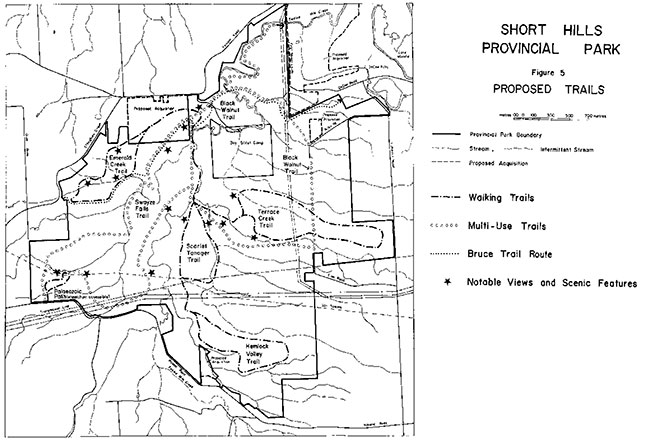
From the parking area, the route crosses open field, rises up a gentle slope to an old road allowance. From this vantage point, a good view of portions of the park can be had. The trail would then turn south along the old road allowance for some 0.5 kilometre, then turning west to follow a creek valley for 0.5 kilometre. After crossing the creek, the route begins the return to the starting point along a ridge then re-crossing the creek valley downstream from a small waterfall. At the valley edge, the trail would emerge from the forest and return through field to the parking lot.
This trail would use both existing informal trails and new routes. To direct traffic away from the unused portion of the road allowance referred to above, planting of trees and shrubs as well as use of temporary fencing would be necessary.
10.1.4 Terrace Creek Trail
Wonderful displays of spring wildflowers and waterfalls cascading over rock outcrops are scattered along this trail (4.5 km). Originating from the southern end of Gilligan Road, the Terrace Creek walking trail crosses a creek, ascends a hill and turns south to arrive at Terrace Creek Falls (see cover). From here the trail follows the north side of Terrace Creek to the road allowance between Wiley and Eller Roads (Figure 5). From there, the trail loops eastward through the woods closest to Cataract Road (Figure 5). The return route passes through a forest north of Terrace Creek and then turns south to join the first part of the trail.
This walking trail uses a number of existing informal trails. It traverses two nature reserve zones. Four small bridges would be required as would some trail resurfacing to remediate existing impacts on the trails. Care will be taken in trail development to avoid the locations of significant plants. Development of this trail will await the end of agriculture in the park by July 1993.
10.1.5 Scarlet Tanager Trail
Leading up a ridge from the southern end of Gilligan Road, the 2.5-kilometre Scarlet Tanager Trail (Figure 5) leads to the top of the plateau and winds south through mixed forest. As the trail emerges from the forest, it turns east and descends into a valley on the east and follows the creek for 0.5 km then out into a field and returns to its starting point near the foot of Gilhigan Road.
A few modest bridges may be required. Resurfacing may also be necessary in a number of sectors or rerouting from existing informal trail routes to avoid areas of trail deterioration.
The eastern section of the trail, in a small valley, would be excellent for interpretation of erosional processes and features such as meanders and oxbows.
10.1.6 Hemlock Valley Trail
The "Hemlock Valley" is a quiet area of deep, secluded ravines, blanketed in forest. The Hemlock Valley walking trail (3 km) winds south and then east through forest, crossing two small valleys and continues eastward to the edge of the wooded area. From this point, the trail turns north and then veers west along a ridge back to the trail’s origin. One light bridge for walkers would be required.
10.1.7 Palaeozoic Path (Wheelchair accessible)
A one-kilometre wheelchair-accessible trail is proposed in the Swayze Falls area (Figure 5). It would run from the parking lot to the Swayze Falls viewing platform, and from thence looping back to the parking lot. This will accommodate walkers and wheelchairs.
10.1.8 Other Trails
The many trails within the park have been evaluated, and 2.5 kilometres of trail are proposed for closure and rehabilitation (Figure 4). The criteria used for deciding on trail closure are: environmental sensitivity; quality of recreational experience; access; interpretive value; and manageability.
The trail through the wetland west of Gilligan Road at the north end of the park must be closed due the soil moisture conditions and impacts on the wetland. A trail on the northern edge of the woodland abutting the plateau at the north end of the park also is very wet during the spring.
The old snowmobile route from the Black Walnut Trail east to the new Terrace Creek Trail is very wet. The old road allowance running south from the south end of Gilligan Road is highly eroded. A trail offshoot from the Swayze Falls Trail which passes above the major slump along the creek must be closed to minimize contribution to the slumping and for public safety reasons. A trail north of the Swayze Falls Trail on the west side of the park is eroded and needlessly duplicates the Swayze Falls route (see Figure 4).
After the "official" park trail system is developed, use of informal trails will be discouraged. Shrub plantings and other means will be used to discourage use of these trails. Use of informal trails will likely decline when marked trails are developed and their use will be monitored.
Development of a self-guiding interpretive trail may be best suited to the Swayze Falls, Emerald Creek or Black Walnut Trails which will likely attract greatest use. Another location may however be desirable depending on the levels of use at the time such a interpretive trail is developed.
10.2 Bruce Trail
The park is about a day’s walk from Queenston, the southern terminus of the Bruce Trail, a long-distance hiking trail over 760 km long. The Bruce Trail forms an essential part of the Niagara Escarpment Parks System and links all the parks and natural features together. The Bruce Trail Association and its constituent clubs of volunteers manage the Bruce Trail. The Bruce Trail Corridor will be planned cooperatively by the Ministry and the Bruce Trail Association as provided for in the Niagara Escarpment Plan and the Bruce Trail Comprehensive Plan. The route shown in Figure 5 is the proposed route within the park. The Bruce Trail Corridor, or potential area for trail routing, includes a large part of the park.
The Bruce Trail presently crosses the park along a route that roughly coincides with sections of the existing yellow and blue trails (Figure 2). Proposed realignment of sections of the Bruce Trail (Figure 5) would avoid sensitive areas, coordinate the Bruce Trail with main park trails and provide a more interesting and scenic route. These changes and future trail management would be done in cooperation with the Niagara Bruce Trail Club and the Bruce Trail Association.
Some Bruce Trail hikers also require lightly developed camping areas for overnight stops. Camp Wetaskiwin presently adequately provides camping for hikers on the Bruce Trail.
10.3 Links with other trail systems
The Bruce Trail links Short Hills with a large hiking trail system. More such linkages and similar ones for horseback-riders and cyclists would be desirable. These could be established in cooperation with municipal governments and cycling and equestrian groups.
In cooperation with the City of St. Catharines, access between St. Catharines and the park will be provided via a walking and cycling trail in the Twelve Mile Creek Valley. This will be a longer term objective and would provide a link with the Merritt Trail which follows much of the Welland Canal (Figure 1).
Possible linkages will be sought with trails or cycling routes developed in Pelham on old railway rights-of-way and on nearby roads.
10.4 Access
The park’s main access point is from Pelham Road (Figure 4). If additional lands adjacent to Pelham Road (Figure 4) are purchased, this site will allow provision of key park facilities.
Within the near future, Gilligan Road will be closed to traffic. Secondary access points will remain at Swayze Falls adjacent to Roland Road, and at Wiley Road (Figures 3 and 5). Parking will also be expanded at both sites.
The many gates in the fencing around the park provide numerous unofficial access points shown in Figure 2. Vandalism, dumping and inappropriate use occurs at some of those locations. Parking and traffic also pose a public safety threat at some access points. Use of five of the ten informal access points (Figure 4) will be discouraged by means of fencing, signs and parking restrictions. This policy will be implemented after the primary and secondary access points are improved.
10.5 Parking areas and toilets
As illustrated in Figure 4, increased parking is proposed at the main access point. Increased parking is also proposed for the secondary access points at Swayze Falls/Roland Road and Wiley Road. Total parking for 80 cars is proposed. Bus parking, vault privies and drinking water would be provided at Pelham Road. Vault privies are also proposed for the Swayze Falls site (Figure 4).
10.6 Interpretive facilities
Heritage interpretation will be low-key and self-use. A park brochure and trail guide will be the basic tools for conveying written messages. A self-guiding nature trail and guide for that trail will also enhance interpretive messages. In the long term, information display panels are proposed to convey interpretive themes.
11.0 Implementation priorities
The proposals in this plan would improve the quality of the visitor’s experience at Short Hills while maintaining the quiet, relaxing nature of those experiences. At the same time, protection and enhancement of the park’s natural environment is a clear priority. The agriculture phase-out, vegetation restoration, zoning, trail rationalization and trail redesign all contribute to protecting the park environment.
The proposals in this preliminary plan will be phased in and are dependent on the availability of funding and the level of volunteer involvement. Funding for many of the initiatives will also require financial partnerships with stakeholder groups or corporate sponsors.
Phase I
- Purchase of lands adjacent to Pelham Road for main access point (Figure 2)
- Increased parking, vault privies and drinking water at Pelham Road
- Cooperating relationships with stakeholder groups; pursuing of additional funding for trail development, vegetation restoration and heritage interpretation
- Development of Emerald Creek, Terrace Creek, Hemlock Valley and Scarlet Tanager walking trails (see Figure 5)
- Construction of the wheelchair accessible Palaeozoic Path (see Figure 5)
- Purchase of lands northeast of the park around DeCew Falls, Beaverdams Creek and Twelve Mile Creek valley (Figure 2)
- Closing of Gilligan Road and removal of buildings
- Signs clearly marking the routes of the Swayze Falls and Black Walnut trails (see Figure 5); closing of worst trail 'sections; preliminary trail improvement
- Directing use by horseback riders and mountain bicycles onto the Swayze Falls and Black Walnut trails; institution of a horseback riding season
- Phase-out of snowmobiling by the end of the 1991-92 winter season
- Phase-out of agriculture by July 1993
- Preparation of a Vegetation Management Plan
- Planting of trees and shrubs on the first' priority areas (see Figure 4 and Appendix)
- Acquisition of road allowances within the park that lie in Pelham and Thorold
Phase II
Major redevelopment of the Swayze Falls and Black Walnut trails (see Figure 5); resurfacing; construction of bridges and fords;
- Increased parking at Swayze Falls/Roland Road and Wiley Road; vault privies at Swayze Falls (see Figure 4)
- Retiring of undesirable access points (see Figure 4)
- Planting of trees and shrubs on second priority areas (see Figure 4 and Appendix); and
- Trail guide
- Management agreements with the Boy Scout Camp, Ontario Hydro and TransCanada Pipelines
- Demarcation of park boundary; removal of fencing within park
Phase III
- Park brochure
- Self-guiding interpretive trail; information display panels
- Preparation of a Stream, Fisheries and Landform Resource Management Plan
- Construction of a work centre at Pelham Road
- Thinning of selected conifer plantations (see Figure 4 and Appendix)
- Trail link-up to St. Catharines via Twelve Mile Creek; and
- Signs on local roads indicating the location of the park
12.0 Summary of public consultation
This management plan was developed in four stages:
Stage 1 - Terms of Reference
Stage 2 - Background Information, Issues and Options
Stage 3 - Preliminary Management Plan
Stage 4 - Approved Park Management Plan
12.1 Stage 1: Terms of reference
Public consultation is an important part of park management planning. This management planning process is to review the 1977 master plan for Short Hills. Stage 1 of the management planning consisted of the preparation of terms of reference. A news release was issued at that time and the terms of reference sent to interested groups and individuals.
During Stage 1, preliminary meetings were also held with members of several stakeholder groups including horseback riders, naturalist clubs, Niagara Bruce Trail Club, Boy Scout leadership, St. Catharines Game and Fish Club, snowmobilers and residents associations. The purpose of those meetings was to explain the planning process, opportunities for public involvement and to identify concerns regarding management of the park.
12.2 Stage 2: Background information, issues and options
Stage 2 of the planning process focused on a report on "Background Information, Issues and Options" (see 14.0 References). That report, a summary of its contents and a news release were widely distributed to interested members of the public. An open house presenting the contents of the report was held to solicit public response. Over 250 people attended the open house. Additional contacts were made by telephone and in person.
Advertisements regarding public comment on the report and the open house were placed in the St. Catharines Standard, the Pelham Herald, the Welland-Port Colborne Tribune. Additional articles in those papers further publicized the need for public comment. Another news release was issued subsequent to the open house to publicize the fact that so many people attended and to reemphasize the deadline for public comment.
Two hundred and eighty responses to the report were submitted including 41 letters and briefs. These responses formed part of the basis for the preparation of the preliminary plan. Appendix A of the preliminary plan presented a detailed summary of public comment.
12.3 Stage 3: Preliminary management plan
Prior to the release of the preliminary plan, meetings were held with the Niagara Bruce Trail Club, Niagara District Snowmobile Clubs Association and equestrian groups to discuss proposals which affected them directly.
Copies of the preliminary plan as well as a summary and questionnaire were distributed widely to all groups identified during previous stages of planning. An open house, news releases, advertisements in local newspapers, correspondence and meetings with interested groups and individuals helped obtain public input. Coverage by local media also publicized the need for public comment.
Presentations were made to the St. Catharines Game and Fish Association, Peninsula Field Naturalists, Regional Niagara Environmental and Ecological Advisory Committee (Natural Areas Subcommittee) and the Niagara Falls Nature Club. Meetings were held with equestrians, snowmobilers, Brock University professors and students, outdoor educators and Ontario Hydro.
One hundred and sixty-eight responses to the preliminary plan were received. These comments were used in drafting this final management plan. The vast majority of responses supported the direction of the preliminary plan. A report summarizing the responses and the original questionnaires are available for inspection at the Ministry of Natural Resources, Niagara area office.
13.0 Plan review and amendment
This management plan will be reviewed at least once every ten years to confirm or revise the resource management, operations and development policies. Minor amendments may be made in the interim as required. Major amendments having broad implications for park management will receive public review.
14.0 References
Albanese, P. Impact of a Hydra Right-of-Way on Tree Dispersal within Short Hills Provincial Park. St. Catharines, Brock University, Institute of Urban and Environmental Studies, Working Paper No. 26, 1987.
Allen, G., P. Eagles and S. Price (eds.) Conserving Carolinian Canada. Conservation Biology in the Deciduous Forest Region. Waterloo, University of Waterloo Press, 1990.
Ambrose, J. and S. Aboud. Status Report on the Cucumber Treet. Magnolia acuminata Ottawa, Committee on the Status of Endangered Wildlife in Canada, 1983.
Ambrose, J. and P. Kevan. Reproductive Biology of Rare Carolinian Plants with Regard to Conservation Management. In: Conserving Carolinian Canada, G. Allen, P. Eagles and S. Price (ed.c.), University of Waterloo, 1990.
Beechey, T. and I.Macdonald. Effinghan-Short Hills Provincial Park: A Biological Inventory Toronto, Ontario Ministry of Natural Resources, 1972
Brady, R. (ed). Enviromnentallv Sensitive Areas of the Regional Municipality of Niagara. St. Catharines, Dept. of Geography, Brock University 1980.
Bruce Trail Association. BruceTrail Comprehensive Plan. Burlington, 1991.
Campbell, C. and D. Coulson and A. Bryant. Status Distribution and Life History Characteristics of Some Butterflies at Risk in the Carolinian Forest Zone of Ontario. In: Conserving Carolinian Canada, G. Allen, P. Eagles and S. Price (eds.), University of Waterloo, 1990.
Cuddy, D., K Lindsay and I. Macdonald. Significant Natural Areas Along the Niagara Escarpment. Toronto, Ontario Ministry of Natural Resources, Parks Planning Branch, 1976.
Davidson, R. Geology and Geomorphology of Short Hills Provincial Park. Toronto, Ontario Ministry of Natural Resources, 1974.
Dunn, J. Short Hills Provincial Park Historical Architecture Report. Toronto, Ontario Ministry of Natural Resources, 1973.
Feenstra, B. H. Quaternary Geology of the Niagara Area. Southern Ontario. Toronto, Ontario Ministry of Natural Resources, 1972.
Gould J. A Biological Inventory and Evaluation of Short Hills Provincial park. Richmond Hill, Ontario Ministry of Natural Resources, 1989.
Hughes, R. J. Glaciation of the Short Hills. St. Catharines. Ontario. Master’s thesis, McMaster University, 1970.
Jackson, J. The Niagara Region: Trends and Prospects, the Challenge of Change. St. Catharines, Brock University, Occ. Publ. No. 4, Dept. of Geography, 1985.
Marshall Mackim Monaghan Limited, Lane Frenchman and Associates, Historical Research Limited, and Welland Canals Society. Welland Canals Corridors Development Guide. St. Catharines, prepared for the Regional Municipality of Niagara, 1988.
Moriyama and Teshima Planners Ltd. Ontario’s. Niagara Parts. Planning the Second Century. A 100-year Vision, a 20-year Plan and a Five-year Action Plan. Toronto, report prepared for the Niagara Parks Commission, 1988.
Niagara Escarpment Commission. The Niagara Escarpment Plan. Toronto, Ontario Ministry of Municipal Affairs, 1985.
Niagara Escarpment Commission. The Five-year Review, Niagara Escarpment Plan Policy Paper 13: The Niagara Escarpment Parks System. Georgetown, Ontario, 1990.
Niagara Escarpment Commission. The Niagara Escarpment Plan Review: Proposed Revisions to the Niagara Escarpment Plan. Georgetown, Ontario, 1991.
Nuzzo, V. Experimental Control of Garlic Mustard [Alliara petiolata (Bieb.) Cavara & Grande] in Northern Illinois using Fire. Herbicide and Cutting. Natural Areas Journal 11: 158-167, 1991.
Nuzzo, V.,J. Kennay and G. Fell. Vegetation Management Guideline: Garlic Musta,rL Aliaria petiolata. Natural Areas Journal 11:120- 121,1991.
Ontario Ministry of Municipal Affairs. Niagara Escarpment Plan Implementation Proposals. Toronto, 1986.
Ontario Ministry of Natural Resources. Short HiIIs. Provincial Park: Background Resource Document. Toronto, Ontario Ministry of Natural Resources, 1972.
Ontario Ministry of Natural Resources. Short Hills Provincial Park Master Plan. Toronto, 1977.
Ontario Ministry of Natural Resources. Niagara District Land Use Guidelines. Fonthill 1983.
Ontario Ministry of Natural Resources. Short Hills Provincial Park Mapping Project (Earth Science). Fonthill 1986.
Ontario Ministry of Natural Resources. Niagara District Fisheries Management Plan, 1989-2000. Fonthill 1986.
Ontario Ministry of Natural Resources. Implementation Strategy: Areas of Natural and Scientific Interest. Toronto, Parks and Recreational Areas Branch, 1987.
Ontario Ministry of Natural Resources. Short Hills Provincial Park Background Information. Issues and Options. Richmond Hill, 1989.
Peebles, E. Short Hills Provincial Park Historical Report. Toronto, Ontario Ministry of Natural Resources, 1974.
Prescott, C. Management of a Multiple-use Water Resource: the Twelve Mile Creek Watershed. St. Catharines, Brock University, Institute of Urban and Environmental Studies, Working Paper No. 5, 1980.
Quigley, It J. Phytosociology of the St. Johns- Effinghan Area. St. Catharines, Brock University, 1973.
Regional Municipality of Niagara. Regional Niagara Official Policies plan. Office consolidation. St. Catharines, Ontario, 1988.
Regional Municipality of Niagara. Natural Areas of the Niagara Region: A Preliminary Survey. St. Catharines, Planning and Development Department 1988.
Regional Municipality of Niagara. Population and Housing Forecasts for Regional Niagara and the Municipalities. St. Catharines, Planning and Development Department, 1989.
Regional Municipality of Niagara. Policy Plan Review. Where Next? A Look to the Future. St. Catharines, Planning and Development Department, 1989.
Reid,D. Wild Turkey Reintroduction. In: Conserving Carolinian Canada, G. Allen, P. Eagles and S. Price (eds.), University of Waterloo, 1990.
Riley, J. Distribution and Status of the Vascular Plants of Central Region. Ontario Ministry of Natural Resources. Parks and Recreational Areas Section, Ontario Ministry of Natural Resources, Richmond Hill, 1989.
Sarvis, A. Brook Trout Distribution and Abundance within Upper Twelve Mile Creek Summer 1984. Fonthill, Ontario Ministry of Natural Resources, 1986.
Short Hills Provincial Park Advisory Committee. Policy Recommendations Report. Toronto, Ontario Ministry of Natural Resources, 1974.
Stenson, D. Characteristics of Bedrock Waterfalls along the Niagara Escarpment in the Niagara Peninsula. Ontario. St. Catharines, Dept. of Geography, Brock University, 1990.
Stothers, D. Niagara Escarpment Archeaological Survey: Short Hills Provincial Park Toronto, Ontario Ministry of Natural Resources, 1971.
von Althen, F.W A Guide to Hardwood Planting on Abandoned Farmland in Southern Ontario. Sault Sainte Marie, Great Lakes Forest Research Centre, 1979.
Appendix
Vegetation restoration areas
The vegetation management section of the management plan (8.2) set out the principles to guide vegetation restoration in areas currently under cultivation, old fields, and selected conifer plantations. This appendix spells out the priority areas for restoration and describes each area, its existing vegetation, soils and desired planting mix. Unless otherwise noted soils are generally lacustrine silty clays. All areas are within natural environment zones except for A2, A3 and C1 which include portions of the Terrace Creek nature reserve zone. Areas discussed are identified by code on Figure 4.
First priority areas
Area A1 - (14 hectares)
Two areas adjacent to Wiley Road are targeted for planting to clearly identify the park boundary and to revegetate two unvegetated streams. A mixture of white ash, oak, other hardwoods, white pine and carolinian species such as tulip tree and shagbark hickory should be used on the upland areas. Adjacent to the watercourses, red-osier dogwood, white cedar and silver maple should be planted.
Area A2- (11 hectares)
Both east and west of the north-south hydro line planting should concentrate on the high ground and use species such as white ash, red oak and white pine. The more extensive areas for planting to the west of the hydro line are meant to complete a north-south habitat corridor linking the hemlock valley area, Terrace Creek, Wetaskiwin Woods and the north of the park. These are primarily upland areas and a mixture of white ash, oak, other hardwood species including selected carolinian species, and white pine should be planted. The one watercourse should be planted with silver maple, white cedar, red-osier dogwood and cranberry viburnum.
Area A3 - (23 hectares)
This area is a major eyesore within the park. The meeting of three hydro lines and the gas pipeline completely disrupt the appearance of the natural landscape. First and foremost, planting must mask the hydro lines and create more natural-looking vegetation. Secondarily, the area will also link the south and north as a habitat corridor. Silt barns, loams and silty clays constitute the soils. Fast-growing, tail species like white ash, red oak and white pine would be primary, mixed with other species, particularly further from the hydro lines. Planting should first focus on the high points of land which will very effectively screen the hydro lines.
Area A4 - (0.5 hectares)
Planting of red-osier dogwood, white cedar and silver maple along two unvegetated watercourses in the extreme southeast of the park would help improve water quality.
Area A5- (25 hectares)
This is also a major eyesore within the park, being completely dominated by the artificial appearance of the hydro corridors. Planted vegetation would eventually mask the presence of the hydro lines. Planting would also assist in creating a continuous east-west habitat corridor and filling in of habitat between existing wooded areas. Species composition should also be fast-growing species like white ash, red oak, smaller components of other hardwoods, and white pine.
Area A6 - (1 hectare)
In this sector, the pipeline corridor creates another major eyesore, particularly as this is a high-use area of the park. The preferred species mix would be white ash, oak, other native hardwoods, white pine and shrubs such as cranberry viburnum and dogwood species.
Area A7- (2.5 hectares)
If the property adjacent to Pelham Road is purchased, planting a 20-metre strip along the boundary will delineate the park edge and screen the presence of Pelham Road and nearby houses. A mixture of white ash, oak, white pine and a mixture of other hardwood species is most desirable.
The area to be planted if the private area is purchased is 2.7 hectares.
Second priority areas
Area B1- (11 hectares)
Between two woodlots on the east side of the park is an area that would be ideal for the filling in of forest Strategic planting between these two woodbots would speed up conversion to forest Soils are of either a loamy and silty clay texture. The composition of planting should reflect present composition in the Cataract Woods. This would likely be white ash, oak, hickory, tulip tree, other hardwoods and white pine. Further investigation of the current composition should take place before planting.
Area B2 - (10 hectares)
Planting this area would help create a continuous north-south forest habitat corridor and link the Terrace Creek woods with Wetaskiwin Woods. Silty clay and loam soils are present Composition should reflect the composition of adjacent forest which would likely include white ash, oak, other hardwoods and white pine.
Area B3 - (10 hectares)
This flat agricultural field is adjacent to a sensitive nature reserve zone and borders Holland Road, a major local road. Planting here will better delineate the park boundary and eventually prevent uncontrolled access to the nature reserve zone. Soils are primarily lacustrine silt barns. Composition of planting should be matched to that in nearby upland forests such as those at Swayze Falls. Likely composition would be white ash, oak, and several carolinian species at lower densities.
Third priority areas
Area C1- (0.5 hectares)
Planted with white spruce and white pine before the park was established, little hardwood or forest understorey growth is evident in this area. The spruce and pine should be thinned to allow hardwood growth.
Area C2 - (4.5 hectares)
Planted 1975-77 with white pine, black walnut, white cedar and small amounts of basswood, green ash and red oak. Selective thinning of pine is recommended.
Area C3 - (1.5 hectares)
Planted with red pine in 1974, not a species indigenous to Niagara, virtually no understorey growth has taken place in this area. Selective thinning of conifers is recommended.
Area C4 - (2.5 hectares)
This site was planted in 1974 and 1977 with red pine, white spruce, white pine, black walnut and white cedar. Virtually no understorey growth has taken place in this area. Selective thinning of conifers is recommended.