Silent Lake Park Management Plan
This document provides policy direction for the protection, development and management of Silent Lake Provincial Park and its resources.
Examination and Adjustment History of Management Direction
| Approval Date | Examination or Type of Adjustment | Examination Outcome | List of Supporting Documents |
|---|---|---|---|
| September 14, 2001 | Minor Amendment | not applicable | Minor Amendment Form |
| March 30, 2012 | Examination | Administrative Update and Amendment | Examination Report, Examination Confirmation Statement |
| March 26, 2015 | Administrative Update | not applicable | Administrative Update Form |
| October 28, 2015 | Amendment | not applicable | Amendment Form |
Amendment Approval Statement
October 28, 2015
Dear Sir or Madam:
I am pleased to approve this amendment to the 1986 management plan for Silent Lake Provincial Park. The amendment provides revised policy direction to enable new park development and resource management projects. Zoning was updated to better reflect the values of the park and existing and proposed development.
I would like to express my appreciation to all those who participated in the planning process.
Sincerely,
Bruce Bateman
Managing Director
Ontario Parks
Approval Statement (1986)
Silent Lake Provincial Park was established in 1975 to provide outstanding outdoor recreation opportunities in the popular Haliburton Tourist area. In developing the Park, attention was given to preserving the natural values of the area and retaining its tranquility and solitude. The Park offers both recreational campers and wilderness enthusiasts an unspoiled environment together with easy access and modern facilities. Silent Lake Provincial Park provides traditional drive-in campsites as well as walk-in sites. In winter cross-country skiing and ice fishing can be enjoyed by the public.
"We are pleased to approve the Silent Lake Provincial Park Management Plan, as official policy for the management and development of this park. The plan reflects this Ministry’s intent to protect natural and cultural features of Silent Lake Park and maintain and develop high quality opportunities for outdoor recreation and heritage appreciation for both residents of Ontario and visitors to the Province."
R.M. Christie
Regional Director, Algonquin Region
Norm R. Richards
Director, Parks and Recreational Areas Branch
Introduction
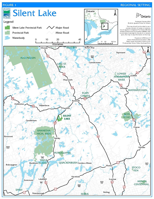
Silent Lake Provincial Park is located in the Municipality of Highlands East, County of Haliburton. Highway 28 runs along its north and northwest boundary providing good road access from the large urban centres of Peterborough, Oshawa and Toronto to the south (Figure 1). The park lies 80 kilometres north of Peterborough, 216 kilometres northeast of Toronto and 24 kilometres south of Bancroft.
This natural environment class park covers an area of 1,610 hectares offering a year-round semi-wilderness experience. The 125 hectare lake known as Silent Lake has pine studded rocky shores and possesses the solitude of a northern lake. Construction initiated on Silent Lake Provincial Park in 1966 and continued until 1978. The park was first opened to the public in the summer of 1975.
All development has taken place in the northern portion of the park leaving the remainder, approximately 80 percent of the park area, in a natural state. The park contains 167 campsites: 35 walk-in, 10 yurts and 122 car campsites divided into three separate camping areas and two campgrounds. All three walk-in camping areas contain vault toilets, water faucets and a central parking area. Both campgrounds are serviced by vault toilets, a centrally located comfort station containing flush toilets, showers and laundry facilities, centralized garbage facilities and water faucets. All of the camping facilities are located in the northeastern corner of the park.
A small day use area located at the north end of Silent Lake contains a parking area, floating docks, a comfort station, and a swimming beach. The maintenance area east of the campgrounds consists of a four-bay maintenance building, fuel storage building, and a four-bay cold storage building.
Activities offered in the park include lake trout and large and smallmouth bass fishing, paddling, swimming, picnicking, and a variety of other activities. Silent Lake Provincial Park has over 35 kilometres of trails for hiking, mountain biking, cross-country skiing and snowshoeing.
Silent Lake Provincial Park is located within the Grenville Province of the Precambrian Shield, 48 kilometres north of its junction with younger sedimentary rocks of southern Ontario. Good examples of glacial abrasion are found on the granitic rocks along the shoreline of Silent Lake. The bedrock geology of this area is complex and several important mineral deposits, especially uranium, are found immediately north of the park. Quartz-sillimanite nodules found in the park’s bedrock are unique to Ontario.
The topography is broken and rolling, and in places precipitous, especially in the vicinity of the shore at the southern end of Silent Lake and in some higher backshore areas. Swamps and wetlands are common throughout the park.
Ecologically, the area lies in Ecodistrict1 5E-11, which is within the Great Lakes-St. Lawrence Mixed Forest zone. Historically, the park area has been selectively cut numerous times, though never clear-cut or completely burnt over. This can be shown clearly by the fact that today some 95 percent of the park area is forested.
The general climate of the park area is classed as typical Humid Continental with warm summers and cold snowy winters, ideal for year-round outdoor recreation activities.
Figure 1: Regional setting
Planning context
The Provincial Parks and Conservation Reserves Act, 2006 (PPCRA) requires that management direction is prepared for each protected area in Ontario. This plan fulfils this requirement, and provides the long term direction for managing the protected area, including the purpose and vision, objectives, zoning, protected area policies and implementation priorities.
The PPCRA has two specific principles that guide all aspects of planning and management of Ontario’s system of provincial parks and conservation reserves:
- Maintenance of ecological integrity shall be the first priority and the restoration of ecological integrity shall be considered.
- Opportunities for consultation shall be provided.
Other legislation (i.e., Endangered Species Act, 2007 (ESA), Ontario Heritage Act, 2005 (OHA)), policies, initiatives (e.g., climate change, invasive species) and best practices (e.g., adaptive management, landscape level planning) also provide additional direction for protecting Ontario’s biodiversity and contribute to guiding protected area planning and management.
This management plan has been updated to be consistent with all relevant legislation and provincial policies. The implementation of projects in this provincial park will comply with the requirements of a Class Environmental Assessment for Provincial Parks and Conservation Reserves (Class EA-PPCR). This may include further opportunities for consultation, as required.
2.1 Ecological integrity
Ecological integrity is a concept that addresses three ecosystem attributes – composition, structure and function. This concept is based on the idea that the composition and structure of the protected area should be characteristic for the natural region and that ecosystem functions should proceed normally. Simply stated, ecosystems have integrity when their lands, waters, native species and natural processes are intact.
Aboriginal communities
Silent Lake Provincial Park is located within the asserted traditional territory of the Williams Treaties First Nations, which includes the Mississaugas (Alderville, Hiawatha, Scugog Island and Curve Lake First Nations) and Chippewas (Beausoleil, Georgina Island and Rama First Nations), and within the Kawartha Nishnawbe asserted traditional territory.
Boundary
Silent Lake Provincial Park was regulated under the Provincial Parks Act in 1977, and is currently regulated under the PPCRA.
In 2000, in response to recommendations within Ontario’s Living Legacy Land Use Strategy (OLL-LUS), the park boundary was amended to add 166 hectares of land to Silent Lake Provincial Park. The addition includes Little Lowrie and Lowrie lakes, Moxley Lake, and the intervening Moxley Creek. These lakes are part of a rich marble-based wetland system. The addition resulted in a total park area of 1,610 hectares.
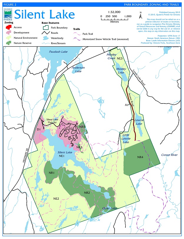
Figure 2: Park boundary, zoning and trails
Park classification
Classification organizes Ontario’s provincial parks into broad categories, each of which has a particular purpose and characteristics which contribute to the overall protected area system. Park classification defines an individual park’s role in providing opportunities for environmental protection, recreation, heritage appreciation and/or science. Classification is a key element in determining the general policy basis for park management which in turn determines the type and extent of activities that may take place in a park.
Silent Lake Provincial Park is a natural environment class park. Natural environment class parks protect outstanding recreational landscapes, representative ecosystems and provincially significant elements of Ontario’s natural and cultural heritage and provide high quality recreational and educational experiences.
Purpose and vision
The purpose of Silent Lake Provincial Park is:
To protect natural and cultural heritage, and provide a variety of high quality, semi-wilderness recreation experiences appropriate to and sustainable within the park’s environment.
The vision for Silent Lake Provincial Park is an intact ecosystem where natural features and communities thrive, and outstanding recreational landscapes are protected.
Park objectives
Natural environment class parks contribute to the achievement of all four established Ontario Parks objectives: protection, ecologically sustainable recreation, appreciation of Ontario’s natural and cultural heritage, and scientific research.
7.1 Protection
To protect a system of provincially significant natural environments incorporating natural, cultural and recreational features.
Several provincially significant life and earth science features are found within the park, and as a whole the park protects a variety of relatively undisturbed ecological communities. Protection will not be limited to provincially significant features. The entire park will be maintained as an ecologically healthy and diverse natural environment, consistent with achieving the park’s other objectives.
7.2 Recreation
To provide day use and camping opportunities appropriate to the park and to provide opportunities to discover and experience the park’s recreational environment.
Paddling, hiking, swimming, picnicking, fishing, cross-country skiing and camping are expected to continue to be the principal recreational activities in the park. Camping and day use will be maintained near present levels in the summer. Ontario Parks will seek to increase camping and day use in the spring, fall, and winter by adding off-season facilities and increasing the suitability of existing park facilities.
For further information on recreation, see Section 9.11.
7.3 Natural and cultural heritage appreciation
To provide opportunities for exploration and appreciation of the park’s natural and cultural heritage.
Individual exploration and appreciation will be encouraged to the greatest extent compatible with and complementary to preservation of the natural environment, earth and life science features and cultural heritage resources of the park.
7.4 Scientific research
To encourage research that furthers our knowledge of the park’s ecological communities, and contributes to understanding and maintaining landscape-level function.
The results of scientific research and monitoring in Silent Lake Provincial Park can be used to help maintain and restore the ecological integrity of the park, by allowing park staff to use the best available scientific information and technology to support planning and management decisions.
See Section 9.14 for more information on research.
Zoning
Zoning is a tool that spatially delineates areas within a protected area that have common management objectives, intentions, values and/or uses.
Zoning is used to describe the type and extent of resource management, operations and uses permitted in a specific part of a protected area. Discrete policies are applied in each zone to enable different management approaches that are appropriate for those areas. These policies are outlined in Section 9.0.
Land within a natural environment class park is zoned to recognize the significance of resources, management implications and capacity for use. Natural environment class parks always include natural environment and development zones, and may also include wilderness, nature reserve, historical and access zones. Silent Lake Provincial Park has four types of zones: development, natural environment, nature reserve and access.
Zoning for Silent Lake Provincial Park is shown in Figure 2 and described below.
8.1 Nature reserve zones (354 ha)
Nature reserve zones include significant earth and life science features that require protection distinct from that in adjacent zones.
Development is limited to trails, necessary signs, and minimal interpretive facilities, where such development will not harm the natural values to be protected.
These zones have been delineated based on the life science survey work that has been done in the park, the originally identified nature reserve and "extreme constraint" zones, the areas formerly identified as Areas of Natural and Scientific Interest (ANSIs)2, and features on the ground that make the boundaries easy to identify. They do not encompass all of the significant and sensitive features of the park, but do include some of the most representative ones.
There are five nature reserve zones in Silent Lake Provincial Park.
NR1 Quartz-sillimanite nodules (31 ha)
One of the most significant features of Silent Lake Provincial Park is the quartz-sillimanite nodules in the Silent Lake Pluton. While these nodules are fairly common in northern Europe, they are unique to Southern Ontario and are the best developed such feature in Canada (Fred W. Breaks, Ontario Geological Survey). According to Dr. M. Easton, Ontario Geological Survey, no other nodules like these have been identified in Ontario. In addition, their occurrence in igneous rock versus metasedimentary rock makes them truly unique.
The nodules appear to be biscuits sitting on the surface of the rock. They are circular to ovoid and range from 5mm to 30cm in length but average about 5-10cm. The nodules are white to light-grey often with pale reddish hues imparted by minute traces of limonite and hematite.
The best nodules outcrop is in an existing campground on the east side of Silent Lake. While the nodules are fairly resistant to foot traffic, some have been damaged by indiscriminate sampling. Nodules on the west side of the lake in NR1 will likely have limited exposure to significant traffic thus facilitating preservation of these important geologic features. Additionally, the value of the nodules to the geoscience community is enhanced by the easy access through the park which would help to facilitate future research.
NR2 Lower silent lakes and hardwoods (179 ha)
This zone encompasses Lost Lake, Quiet Lake, the Third Silent Lake, and the intervening forest communities at the south end of the park. This zone includes areas formerly identified as the provincially significant Third Silent Lake and Lost Lake Bog ANSIs. The boardwalk junction of the hiking and mountain biking trails is located in this zone, and will be managed to ensure that the zone’s sensitive features are not compromised.
Lost Lake, Quiet Lake, and the Third Silent Lake are small, relatively undisturbed lakes supporting shoreline fen3 and floating fen mat communities, where uncommon plant species are found. Quiet Lake receives regular canoe and kayak traffic along a well-worn portage. The water levels in Lost Lake have increased since the original management plan due to beaver activity, and visitors are now bringing their vessels into Lost Lake. This activity may be discouraged through education to avoid disturbance to sensitive fen vegetation and to wildlife.
The intervening upland areas support a variety of forest types, including rich mature hardwood forests and sheltered valleys. These areas are influenced by the calcareous bedrock and contain species with more southern affinities, including some regionally rare ferns.
The zone also provides diverse wildlife habitat for breeding waterfowl, forest birds, and amphibians. A small colony of great blue herons has been present in Lost Lake since the 1970s, although it has not been surveyed recently to confirm if it is still active.
NR3 Sedge meadow marsh (3 ha)
This area is a meadow marsh, which is a successional wetland stage that sometimes results from the natural evolution of wetlands in this landscape due to beaver activity and other influences. It has not been surveyed recently but is likely to support uncommon wetland species that are not widespread in the park. This sedge meadow marsh is the largest example of this community type within the park. Pincer Bay Campground is immediately adjacent to it but is currently not having a negative influence on it. The meadow marsh feeds a small stream that drains into Silent Lake.
NR4 Hardwood valleys (127 ha)
This zone is located just south of the Lowrie Lakes on the east side of the park, and encompasses an area formerly identified as a provincially significant ANSI. This area has been identified as one of the most significant and sensitive areas of the park. It is composed of mature tolerant hardwood forests, with intermittent streams and deciduous and coniferous swamps in the lowlands.
The valleys within this zone are particularly rich and diverse, due to the calcareous influence of the bedrock and the humid sheltered microclimates. These areas support a high diversity of fern species.
NR5 Bonnie’s Pond forests (14 ha)
This rich hardwood forest supports ephemeral streams and ponds that drain into Bonnie’s Pond, a wetland that includes fen communities. Some of the forests within this zone have been identified through forest resource inventory as being over 100 years old.
8.2 Natural environment zones (1142 ha)
Natural environment zones include natural, mostly undisturbed landscapes in which minimum development is required to support low-intensity recreational activities.
Development will be limited to portages, trails and necessary signs for route identification, minimal interpretive facilities where appropriate, and basic facilities to support low-intensity recreation, as well as protect representative earth and life science features.
NE1 Silent Lake (117 ha)
The entire body of Silent Lake including the lake shoreline are within this zone. This is one of few lakes of this size in the area with an undeveloped shoreline. Its fish community is healthy and includes Lake Trout. Shoreline development will continue to be limited to the development zones. There are several existing locations used for swimming and picnics along the shoreline. Canoe rentals are offered seasonally.
NE2 Upland forests and wetlands (848 ha)
Most of this zone is composed of a variety of mature upland hardwood and mixed forests, with smaller marsh and swamp wetland areas. The topography is rugged and there are frequent small streams and waterbodies or seasonally wet areas. There are several areas of large, mature white pine, hemlock, and maple. This zone contains a system of hiking, mountain biking, cross-country ski and snowshoe trails.
NE3 Moxley, Lowrie and Little Lowrie Lakes (177 ha)
Moxley, Lowrie, and Little Lowrie Lakes are part of a rich, marble-influenced wetland complex. Sport hunting is permitted in this zone (see Section 9.11). Other existing land uses such as commercial fur harvesting and private recreation camps (see Section 9.2, 9.3 and 9.7) will continue in this zone.
8.3 Development zones (112 ha)
These zones will provide the main access to the park facilities for a wide range of day use and camping activities. Development zones are a relatively small portion of natural environment class parks. Given the topography and hydrology of the park, there is little available area for future development. Current development zones are constrained by steep or wet areas, and contain many small wetlands and streams.
There are two development zones in Silent Lake Provincial Park:
D1 Administration, day use and cabin campground (34 ha)
This zone includes the park office/gatehouse/store, trailer sanitation station, day use area, cabin campground and Silent Lake Park Road providing access to the campgrounds and park maintenance buildings.
D2 Granite Ridge and Pincer Bay Campgrounds (78 ha)
This zone includes the two main car campgrounds, park maintenance area, central waste collection system, and constructed wetland waste management system.
8.4 Access zones (2 ha)
Access zones serve as staging areas, a means of both providing and regulating use in areas of a park geared towards extensive recreation. Generally development is limited to roads, visitor control structures and group campgrounds.
A1 Access road (2 ha)
This road provides access to sport hunting in NE3 and other land uses (see Section 9.11).
Policies
This section provides site specific management policies and any associated actions required to effectively manage this provincial park in accordance with applicable legislation and provincial policies. Section 10 provides a list of priority actions identified for this provincial park.
9.1 Vegetation
Vegetation management including, but not limited to, invasive species control and eradication, and tree planting, may be used to maintain or restore natural environments.
Additional alien plant species4 will not be deliberately introduced to the park. If alien plant species threaten natural heritage values, they will be managed, subject to the Class EA-PPCR and specific provincial policies or legislation.
Extirpated native species may be reintroduced if biologically feasible and desirable for perpetuating park values, using seed stocks native to the park or surrounding area if possible.
Some management practices will produce small quantities of wood as by-products of hazard and dead tree removal. The wood, depending on type and quality, may be used for required items within the park, but when feasible will be left in place to contribute to the forest ecosystems.
9.2 Wildlife
The management of wildlife will be directed toward promoting healthy populations and diverse communities. Management will follow requirements of the Class EA-PPCR.
Animal populations, including problem domestic animals and hyperabundant native species, may be controlled when essential to protect human health and safety, natural heritage values, the health of species outside the park, or the values for which the park was established. The park will use visitor education to reduce conflicts between visitors and healthy native animals. Conflicts that have arisen due to visitor behaviour, such as feeding and littering, and are not considered to be endangering human health and safety, will normally not require animal control. When animal control is necessary, techniques with minimal effects on the balance of the park’s environment will be used. Any animal control measures (e.g., hunting, trapping) will be implemented directly by, or under the direct supervision of, Ontario Parks.
Wildlife habitat enhancement, rehabilitation and restoration may occur when ecologically appropriate (e.g., turtle nesting habitat creation, fish spawning shoals).
Additional alien animal species will not be deliberately introduced into the park. If already established alien species threaten park values, they will be managed or eradicated if feasible and practical. Extirpated native species may be reintroduced, and existing populations replenished, if biologically feasible and acceptable, and desirable in terms of perpetuating park values.
For information on commercial harvesting and sport hunting within Silent Lake Provincial Park, see Sections 9.9 and 9.11 respectively.
9.3 Fisheries
The fisheries of Silent Lake and other waterbodies within the park boundary will be managed in accordance with the Ministry of Natural Resources and Forestry (MNRF) Fisheries Management Zone 15.
Wherever possible, fisheries management within the park will seek to maintain and enhance native, self-sustaining fish populations. Certain park waterbodies may be closed to fishing temporarily or permanently for fisheries research or management purposes.
For information on commercial baitfish harvesting and sport fishing within Silent Lake Provincial Park, see Sections 9.9 and 9.11 respectively.
9.4 Fire management
Ontario Parks recognizes fire as an essential ecosystem process, fundamental to restoring and maintaining the ecological integrity of protected areas. MNRF is responsible for responding to forest fires at Silent Lake Provincial Park because it is located Inside the Fire Region (IFR).
Fire management involves the protection of values and the attainment of resource management objectives through two main areas:
- fire response: the protection of people, property and natural areas from forest fire; and
- fire use: the strategy of maintaining forest fire as an ecological process or meeting resource management objectives through the application or management of prescribed fire.
Fire management within Silent Lake Provincial Park will help to restore and maintain ecological integrity while preventing personal injury, value loss or social disruption. In particular it may help to enhance habitat for certain flora and/or fauna, such as white pine regeneration.
The use of fire through prescribed burning to achieve ecological or hazard reduction objectives may be considered. Plans for any prescribed burning will be developed in accordance with the Class EA-PPCR and other MNRF policy.
9.5 Species at risk
Species at risk5 and their habitat will be protected in a manner consistent with the ESA and associated regulations.
As of January 2015, six species at risk have been confirmed within the park, and others are likely to be present. One species of particular note is the eastern hog-nosed snake (threatened). This secretive species has only been seen in the development zones, including dead individuals on the park roads. Silent Lake is near the eastern edge of the eastern hog-nosed snake’s range in Canada.
Recovery actions (e.g., projects to enhance, rehabilitate, restore or manage habitat) may be implemented in accordance with relevant government response statements and Ontario Parks policies.
9.6 Insects and disease
Native insects and diseases affecting vegetation will be allowed to progress naturally, except where they threaten significant natural heritage values in nature reserve or natural environment zones, or significant aesthetic values in development zones, in which cases they may be controlled where feasible and ecologically appropriate.
Alien insects and diseases will be controlled where feasible. Where control is undertaken, it will be directed as narrowly as possible to the specific insect or disease so as to have minimal effects on the rest of the park’s environment. Biological controls will be used whenever possible.
9.7 Land
There are two private recreation camps within the Silent Lake Provincial Park boundaries under the authority of land use permits (LUPs). Extended tenure may be granted by Ontario Parks, by increasing the term of the existing tenure, but the type of tenure will not change. Any addition or improvement to existing recreation camps or access roads identified in the LUPs requires a work permit issued by Ontario Parks under the PPCRA.
A hydro-electric transmission line formerly passed through the northern portion of NE3. It has been relocated outside the park. New hydro-electric development will not be permitted.
Ontario Parks will support, in principle, adding property to the park, provided the addition is anticipated to enhance park values. If suitable lands within, nearby or adjacent to the park become available for addition they will be evaluated with regard to their contribution to park objectives, willing seller/willing buyer and other factors including available funding. Any park addition would require a change to regulation and an amendment to the Crown Land Use Policy Atlas.
9.8 Water management
Water quality will be monitored by the park’s present water quality sampling program. Any deterioration in the water quality will be investigated by MNRF. Appropriate action will be taken to maintain water quality and solve the problem.
9.9 Industrial and commercial uses
No industrial extraction of resources will be permitted within the park.
There is a portion of a licenced bear management area (BMA), commercial fur harvest area and commercial baitfish harvesting area in NE3. Commercial harvesting may continue subject to the conditions attached to each licence. New commercial licence areas will not be considered.
9.10 Cultural heritage
Cultural heritage values that may be impacted by any provincial park projects and/or activities shall be identified and managed (i.e., protected, maintained, used and disposed of) in accordance with MNRF's Technical Guideline for Cultural Heritage Resources (2006) and other relevant cultural heritage documents.
9.11 Recreation and travel
Silent Lake will provide opportunities for hiking, paddling, sailing, fishing, swimming, cross-country skiing, mountain biking, snowshoeing and other outdoor activities on a seasonal basis. Power boats are not permitted in Silent Lake Provincial Park.
Paddling will be discouraged in Lost Lake. This may be done through education and interpretive information in the park tabloid, and/or through signage.
An existing mountain bike trail passes through NR2 and NR5. It is considered a non-conforming use that will be permitted to continue. Minor mountain bike trail maintenance and reroutes may occur to protect park values or for health and safety reasons.
Sport fishing is subject to provincial and federal fisheries regulations (e.g., the Fish and Wildlife Conservation Act, 1997 (FWCA) and the Fisheries Act (Canada)) as set out in the Ontario Recreational Fishing Regulations Summary. The use of a portable ice fishing hut is permitted, providing that it is not left unattended or overnight in the park. Ontario Parks intends to propose an amendment to existing regulations under the PPCRA to prohibit the possession of power ice augers in Silent Lake Provincial Park.
Sport hunting is permitted in NE3 subject to the FWCA and applicable provincial and federal hunting regulations. Ontario Parks intends to amend existing regulations under the PPCRA and FWCA to add approximately 14 hectares to the permitted hunting area of Silent Lake Provincial Park. The use of hunting blinds or stands in NE3 is permitted, providing that they are of a temporary nature. These must be removed at the end of the hunting season. Sport hunting is prohibited elsewhere in the park.
The access road (A1) is used by authorized motorized vehicles (all-terrain vehicle (ATV), 4x4) and motorized snow vehicles in the winter. This road provides access to private recreation camps. Road maintenance is the responsibility of the tenure holders, subject to the approval of a work permit.
An existing Ontario Federation of Snowmobile Clubs (OFSC) trail operated by the Paudash Trail Blazers Snowmobile Club enters NR4 from the access road (A1), travels south along the east side of the zone through one of the valleys and exits into private land south of the park. This is a non-conforming use that will be permitted to continue.
A person may only operate a motorized vehicle (ATV, motorized snow vehicle) on the access road for the following purposes:
- access to tenured land (e.g. recreation camps);
- access for commercial licence holders;
- access to OFSC trail; or
- access to areas for sport hunting and fishing purposes.
Use of a motorized vehicle off of the access road (A1) is prohibited.
9.12 Education
Provincial parks have a role in supporting the education objective in the PPCRA. The manner in which that objective is met will vary for each park and may be adapted based on the park’s resources and MNRF's direction and priorities at the time. For further direction on park education and programming, refer to the strategic direction for education in Ontario Parks and additional park specific education plans.
9.13 Marketing
Silent Lake Provincial Park will be operated consistent with the overall marketing strategy of Ontario Parks. Marketing may include: promoting the park on the basis of its natural and cultural heritage values and recreational opportunities, and appropriate enjoyment and appreciation of those values and opportunities, promoting year-round use.
9.14 Research
Research by qualified individuals that contributes to knowledge of natural and cultural history and to environmental and recreational management will be encouraged.
Research activities require authorization issued under the PPCRA, consistent with Research Authorization Policy for Provincial Parks and Conservation Reserves. Research is subject to development and management policies associated with the park’s classification, unless special permission is given. Research must meet all requirements under applicable provincial and federal legislation, and may require additional permits or approval (e.g., MNRF Wildlife Scientific Collector authorization or ESA permits).
9.15 Development
Development will proceed in accordance with the Class EA-PPCR, ESA, OHA, other applicable provincial legislation and policies, and the following guidelines. All development undertaken by Ontario Parks or by concessionaires on its behalf will be carried out in accordance with approved site and development plans that meet development standards for provincial parks. Development projects will be phased according to the implementation priorities (Section 10.0) as needed and as funding permits.
9.15.1 Roofed accommodation
Various types of roofed accommodation structures (including yurts, rustic, standard or premium cabins, or other types of structures) may be constructed on existing campsites or in other suitable areas within the development zones.
9.15.2 Day use area
Redevelopment of the existing day use parking area in D1 is necessary to accommodate the increasing numbers of day users during winter and summer use. The need for additional parking will be considered prior to or in conjunction with any further development of the day use area.
An all-season structure will be built in the day use area (D1). The building will be used as a warm-up facility for skiers and anglers in the winter, and an open air picnic shelter during inclement summer weather.
9.15.3 Granite Ridge Campground redevelopment
Due to inconsistent use and a demand for more car campsites, the 22 site walk-in campsite complex located adjacent to Granite Ridge Campground has been redeveloped. The former walk-in campsite complex parking area was removed. The 10 sites located near the former parking area have been converted into a small car campground.
The remaining 12 sites will continue to operate as walk-in campsites with a new service road and parking area providing access to these campsites from Silent Lake Park Road. This area may be converted to an alternate roofed accommodation campground based on user demands, which may include changing the existing walk-in trail to a small road and adding electrical services. Any development in this area will be carefully planned to maintain or restore the integrity of the wetland features in this area.
9.15.4 New campground and campsite development
A campground will be developed on the northwest shore of Silent Lake (D1) to meet demands for camping opportunities. The total number of sites will be determined through site and development planning; a minimum of 10 cabin sites will be added with additional sites added based on user demand. Access will be by a new road constructed to the north of the day use area.
Dependent on user demand, a new campground loop with up to 15 campsites may be developed adjacent to the existing Granite Ridge walk-in parking area (D2).
A new barrier-free electrical campsite may be developed in the existing Pincer Bay Campground loop adjacent to the Pincer Bay comfort station (D2).
Design criteria for these campgrounds will be consistent with Ontario Parks guidelines. They will contain facilities similar to those in the existing campgrounds, such as strategically placed vault toilets, water supply facilities, electrical services and access roads. These campgrounds may include walk-in sites, car campsites and/or various types of roofed accommodation (cabins, yurts, etc.).
9.15.5 Park entrance redevelopment
The entrance of the park will be redeveloped to more efficiently serve park users. The existing gatehouse will be replaced with a new building to house the park gatehouse, office and store. The park entrance roadways will be redesigned and parking areas for park users and staff will be added. The trailer sanitation station will be upgraded, including expansion of the access road, to improve vehicle movement through the station.
9.15.6 Parking area redesign
The parking area adjacent to the Pincer Bay canoe launch may be expanded to add approximately 6 parking spaces. The nearby road may also be reconfigured to ensure user safety by improving vehicle movement around a corner.
The parking area for Bonnie’s Pond Trail may be expanded south toward Silent Lake Park Road to create a safer turnaround for park users and park maintenance vehicles.
9.15.7 Central waste collection
A centralized waste collection system to manage park garbage may be developed in D2. The roadways in the maintenance area may need to be reconfigured to accommodate the centralized waste collection system.
Implementation priorities
This section lists actions and associated projects identified in the plan and prioritizes them for implementation. Actions and projects appear in chronological order according to the individual project priority.
Priority
Rating Project Description
- Cabin Campground development (Section 9.15.4)
- Day use parking redevelopment (Section 9.15.2)
- Park entrance redevelopment (Section 9.15.5)
- All-season shelter development (Section 9.15.2)
- Other campsite development/redevelopment (Section 9.15.1, Section 9.15.3 and Section 9.15.4)
- Parking area redesign (Section 9.15.6)
- Centralized waste collection system (Section 9.15.7)
Implementation of the above actions is subject to:
- applicable legislation and provincial policy;
- a Class EA-PPCR; and,
- availability of financial and human resources.
Examination and adjustment of management direction
This plan will be examined after it has been in place for 20 years to determine whether it is still relevant, effective and current or if adjustments are needed. In circumstances where the plan is not providing sufficient direction, or to address specific issues or pressures, it can be examined prior to the next scheduled examination.
External requests for amendments to address specific proposals or needs may be considered. Ontario Parks can provide further guidance on the process for requesting an amendment and whether specific requests can/will be considered.
A minor amendment to this management plan was approved in 2001 to reflect the OLL-LUS addition to Silent Lake Provincial Park and policy direction in the OLL-LUS.
An examination of the 1986 Silent Lake Provincial Park Management Plan was completed in 2012. The examination outcome called for an administrative update and amendment to the management plan. The administrative update was required to make minor editorial changes and update information. The administrative update was completed and approved in spring 2015. An amendment to the Silent Lake Provincial Park Management Plan (1986) was completed and approved in fall 2015.
Public consultation
A preliminary management plan was written and made available to park visitors, adjacent landowners and local township offices to be reviewed and commented on. Very few comments were received. Most were in agreement of what was being proposed. Subsequently, the Silent Lake Park Management Plan was approved in 1986.
Prior to the regulation of the OLL-LUS park addition, consultation with the public and a local Aboriginal community was conducted during the Ontario’s Living Legacy boundary review process (1999-2000) and the Lands for Life planning process. Local landowners and interest groups were informed of the boundary and policy changes and were invited to comment. Notice of the boundary regulation amendment was posted on the Environmental Registry of the Environmental Bill of Rights (EBR) on August 23, 2000.
The 2001 minor amendment did not require public consultation. Changes from this amendment were incorporated into the management plan through an administrative update in 2015. There are no consultation requirements for an administrative update.
In spring/summer 2015, Aboriginal communities, stakeholders and the public were invited to participate in the development of an amendment to the Silent Lake Provincial Park Management Plan (1986). Class EA-PPCR consultation requirements for two Category B projects (cabin campground development and park entrance redevelopment) were carried out concurrently with the timing of the plan amendment consultation process. Invitation for comment was distributed through:
- Direct mailings/emails to eight local Aboriginal communities.
- Policy proposal notice posted on the Environmental Registry of the EBR for a 47-day comment period ending July 13, 2015.
- Direct mailings/emails sent to approximately 165 individuals/groups:
- relevant government and stakeholder group contacts considered mandatory for park management planning
- adjacent landowners and local stakeholder groups
- Media ad placed in the Bancroft Times local newspaper (May 28, 2015).
- Notices were posted at the Silent Lake Provincial Park office, gatehouse and on bulletin boards throughout the park (May 27, 2015).
- The proposed management plan amendment was posted on the Ontario website on May 27, 2015 (link from the project notice and EBR Environmental Registry).
A total of ten (10) responses to the proposed amendment were received from Aboriginal communities (2), individuals (5), stakeholder groups (1) and government agencies (2). The majority of amendments to the plan received no comments.
Of the respondents, four (4) submitted comments about the park’s hunting policies. All four comments were supportive of the new natural environment zone (hunting permitted). These four comments also expressed concern with lack of hunting areas in the remainder of Silent Lake Provincial Park, with three comments specifically concerned with NR4.
Minor changes were made to sections 2.0 and 9.15 to add more explicit reference to obligations under the OHA. No changes were made to the hunting policies for the park as a result of comments received. NR4 is one of the most significant and sensitive areas of the park due to its diverse and rare plant communities. Hunting will continue to be prohibited in NR4. Hunting is permitted in NE3 (177 ha).
References
Brdar, C. 2015. Silent Lake Life Science Summary. Ontario Parks, Southeast Zone.
Breaks, F.W. 1971. Origin of the Silent Lake Pluton and its quartz-sillimanite nodules, near Bancroft, Ontario. M.Sc. Thesis, McMaster University: Hamilton, Ontario.
Breaks, F.W. and Shaw, D.M. 1977. The Silent Lake Pluton, Ontario: a nodular, sedimentary, intrusive complex. Lithos. 6(2):103-121.
Brunton, D. 1990. Life Science Areas of Natural and Scientific Interest in Site District 5E-11. Ontario Ministry of Natural Resources, Eastern Region, Kemptville.
Conrad, M. 2000. Silent Lake Park Addition, Natural Heritage Area – Life Science Checksheet. Ontario Parks, Southeast Zone.
Conrad, M. 2000. Silent Lake Provincial Park Addition – Field Reconnaissance Report. Ontario Parks, Southeast Zone.
Cordiner, G.S. 1977. A Reconnaissance Earth Science Inventory of Silent Lake Provincial Park, Algonquin Region, Division of Parks.
Dickson, H.L. 1979. A Reconnaissance Life Science Inventory of Silent Lake Provincial Park, Ministry of Natural Resources, unpublished report.
Easton, M. 2014. Personal communication on quartz-sillimanite nodules in Silent Lake Provincial Park. Ministry of Northern Development and Mines, Ontario Geological Survey.
Endangered Species Act, 2007.
Environment Canada. 1976. The Tourism and Outdoor Recreation Climate of
Ontario, Atmospheric Environment Service, Department of the Environment, Ottawa.
North-South Environmental. 2004. Life Science Report: Silent Lake Provincial Park and Additions. Unpublished report prepared for Ontario Parks.
Ontario Heritage Act, 2005.
Ontario Ministry of Natural Resources. 1974. Provincial Parks Statistics. Toronto, Division of Parks, 1974-1984.
Ontario Ministry of Natural Resources. 1978. Ontario Provincial Parks Policy, Queen’s Park.
Ontario Ministry of Natural Resources. 1982. Economic Impact of Provincial Parks in Ontario: A Summary Report, Parks Planning Section, Toronto.
Ontario Ministry of Natural Resources. 1982. Provincial Park User Survey Analysis of Data, Parks Planning Section, Toronto.
Ontario Ministry of Natural Resources. 1983. Bancroft District Land Use Guidelines, Regalia Lands Office.
Ontario Ministry of Natural Resources. 1985. Provincial Park Winter Survey Statistical Summary, Parks Planning Section, Toronto.
Ontario Ministry of Natural Resources. 1992. Ontario Provincial Parks Minimum Operating Standards (Revised).
Ontario Ministry of Natural Resources. 1992. Ontario Provincial Parks Planning and Management Policies. Toronto: Parks and Natural Heritage Policy Branch.
Ontario Ministry of Natural Resources. 1999. Ontario’s Living Legacy Land Use Strategy, Parks Planning Section, Toronto.
Ontario Ministry of Natural Resources. 2005. A Class Environmental Assessment for Provincial Parks and Conservation Reserves. Peterborough.
Ontario Ministry of Natural Resources. 2006. A Technical Guideline for Cultural Heritage Resources for Projects Planned Under the Class Environmental Assessment for MNR Resource Stewardship and Facility Development Projects and the Class Environmental Assessment for Provincial Parks and Conservation Reserves.
Ontario Ministry of Natural Resources. 2009. Ontario Protected Areas Planning Manual.
Ontario Ministry of Natural Resources. 2010. Species at Risk in Ontario List.
Ontario Ministry of Natural Resources. 2011. Ontario’s Crown Land Use Policy Atlas.
Ontario Ministry of Natural Resources. 2011. Our Sustainable Future: A Renewed Call to Action – Ministry of Natural Resources Strategic Directions. Peterborough.
Ontario Ministry of Natural Resources. 2012. Biodiversity: It’s In Our Nature. Ontario Government Plan to Conserve Biodiversity, 2012-2020. Queen’s Printer for Ontario. Toronto, ON. 42 pp.
Ontario Ministry of Natural Resources. 2014. Ontario Protected Areas Planning Manual: 2014 Edition. Peterborough. Queens Printer for Ontario. 33pp.
Provincial Parks and Conservation Reserves Act, 2006.
1 In Ontario, the Ministry of Natural Resources and Forestry delineates natural regions to enable landscape planning and monitoring. Ontario is divided into 71 Ecodistricts based on landforms and biological productivity. For protected area system planning purposes, protected area establishment is designed to be representative of the Ecodistricts in which they are found.
2 ANSIs are areas of land and water containing unique natural landscapes or features. These features have been scientifically identified as having life or earth science values related to protection, scientific study or education.
3 Fens form in areas where groundwater discharges to the surface; they tend to be less acidic and have more nutrients than bogs.
4 In this plan, "alien species" means species that have been unintentionally or deliberately introduced by human activity into areas outside their natural past or present distribution.
5 In this plan, "species at risk" means species listed by MNRF on its Species at Risk in Ontario List (SARO) as endangered, threatened, or special concern in Canada by the Committee on the Status of Endangered Wildlife in Canada (COSEWIC).
Figure 1: Regional Setting
Figure 2: Park boundary, zoning and trails
Additional copies of this publication can be obtained from the Ministry of Natural Resources and Forestry:
Silent Lake Provincial Park
1589 Silent Lake Park Road
P.O. Box 219
Bancroft, Ontario
K0L 1C0
Phone: 613-339-2807
62919 (Print)
62920 (PDF)
ISBN 978-1-4606-6616-6 (Print)
ISBN 978-1-4606-6617-3 (PDF)