Sioux Narrows Provincial Park Management Plan
This document provides policy direction for the protection, development and management of Sioux Narrows Provincial Park and its resources.
© 2014, Queen’s Printer for Ontario
Additional copies of this publication are obtainable from the Ministry of Natural Resources and Forestry from:
http://www.OntarioParks.com/planning (Link no longer active)
or from the Sioux Narrows Provincial Park office:
Sioux Narrows Provincial Park
P.O. Box 5080, 808 Robertson Street
Kenora, ON
P9N 3X9
Telephone:
52747
0.075k P.R., 13 08 2
ISBN 978-1-4606-3032-7 (Print)
ISBN 978-1-4606-3033-4 (PDF)
Cette publication hautement spécialisée Sioux Narrows Park Management Plan n'est disponible qu'en Anglais en vertu du Règlement 411/97 qui en exempte l'application de la Loi sur les services en français. Pour obtenir de l'aide en français, veuillez communiquer avec Michèle Proulx au ministère des Richesses naturelles au
Examination and Adjustment of Management Direction
The following table serves as a record of adjustments and examinations of management direction.
| Approval Date | Examination or Type of Adjustment | Examination Outcome (where applicable) | List of Supporting Documents (do not hyperlink) |
|---|---|---|---|
|
|
e.g., amendment form, update form, secondary plan, examination confirmation statement |
Approval statement
I am pleased to approve the Sioux Narrows Provincial Park Management Plan as the official policy for the management and development of this protected area. The plan reflects the intent of the Ministry of Natural Resources and Forestry, Ontario Parks to protect the natural and cultural features of Sioux Narrows Provincial Park and to maintain and develop opportunities for high quality ecologically sustainable outdoor recreation experiences and heritage appreciation for the residents of Ontario and visitors to the province.
This document outlines the policies and implementation priorities for the park and summarizes the Aboriginal community, stakeholder and public involvement that occurred as part of the planning process. In accordance with the provisions of the Provincial Parks and Conservation Reserves Act, 2006 (PPCRA) two opportunities for involvement were provided. This included an opportunity to review the background information document and a separate opportunity to review the preliminary management direction document. Involvement approaches included direct notices, newspaper advertisements, the Ontario Parks· website and postings on the Environmental Bill of Rights, 1993 registry.
The plan for Sioux Narrows Provincial Park will be used to guide the management of the park over the next 20 years. During that time, the management plan may be reviewed to address changing issues or conditions, and may be amended as the need arises. This plan will be examined in accordance with the provisions of the PPCRA in 20 years.
I wish to extend my sincere thanks to all those who participated in the planning process.
Yours truly,
Signed by:
Bradley Fauteux
Managing Director
Ontario Parks
Date: 27/10/2014
1. Context
1.1 Provincial Parks and Conservation Reserves Act
The Provincial Parks and Conservation Reserves Act, 2006 (PPCRA) is the legislation that guides the planning and management of the protected areas system. The PPCRA has two specific principles that guide all aspects of planning and management of Ontario’s system of provincial parks and conservation reserves:
- Maintenance of ecological integrity shall be the first priority and the restoration of ecological integrity shall be considered
- Opportunities for consultation shall be provided (2006, 12, s. 3)
1.2 Aboriginal communities
Sioux Narrows Provincial Park lies within the Treaty 3 Area. Treaty 3 includes a large area that extends from Lake Winnipeg (Manitoba) in the west to Dog Lake in the east and includes Lake of the Woods, Red Lake and Lac Seul. Treaty 3 is comprised of 28 First Nations in northwestern Ontario and southeastern Manitoba.
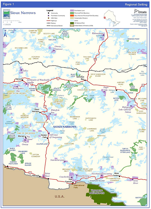
There are several nearby Aboriginal communities including Ojibways of Onegaming (Sabaskong), Anishinaabeg of Naongashiing (Big Island), Big Grassy River, Naotkamegwanning (Whitefish Bay), Anishinabe of Wauzhushk Onigum (Rat Portage), Northwest Angle #37, Northwest Angle #33, Shoal Lake #40, Iskatewizaagegan # 39 Independent First Nation, Ochiichagwe'babigo'ining (Dalles), Rainy River, Couchiching, Naicatchewenin, Obashkaandagaang (Washagamis Bay), Mitaanjigamiing (formerly Stanjikoming), Grassy Narrows, Wabauskang, Wabaseemoong, Eagle Lake and Wabigoon Lake (Figure 1).
In addition, the Kenora, Northwest, and Sunset Country Métis Councils are located within this geographic area.
Aboriginal interests and use within Sioux Narrows Provincial Park are not completely known.
1.3 Planning context
This park management plan has been prepared consistent with direction contained in Our Sustainable Future: A Renewed Call to Action, Ministry of Natural Resources Strategic Directions (OMNR 2011a) and Biodiversity: It’s In Our Nature (2012-2020), the Ontario Government’s plan to conserve biodiversity.
The Sioux Narrows Park Management Plan has been developed in accordance with the PPCRA, Ontario Provincial Parks Planning and Management Policies (OMNR 1992), Ontario’s Living Legacy Land Use Strategy (OMNR 1999) and approved land use policies as reflected by the Crown Land Use Policy Atlas (CLUPA) (except where changes are proposed by this plan). In accordance with this plan, the OMNR may amend affected area-specific land use policies and mapping found in the CLUPA.
All activities undertaken in Sioux Narrows Provincial Park must comply with A Class Environmental Assessment for Provincial Parks and Conservation Reserves (Class EA PPCR), where applicable (OMNR 2005).
1.4 Involvement
1.4.1 Summary and results of aboriginal involvement
Aboriginal involvement is an important part of the Sioux Narrows park management planning process. The following provides a summary of the opportunities made available for Aboriginal people to become involved in the planning process and a summary of the results.
Twenty nearby Aboriginal communities were contacted about Phase 1 (invitation to participate and background information) in September 2007 and again in August 2009. Two communities requested planning materials. These materials were provided.
During Phase 1, one community requested an opportunity for involvement. The park superintendent made a presentation in September 2009 to elders of another community upon request.
The public open house held on August 21, 2013 during the comment period for the preliminary management plan was held in the community of Naotkamegwanning (Whitefish Bay).
No comments related to the content of the preliminary management plan were submitted.
1.4.2 Summary and results of public involvement
Public involvement is an important part of the Sioux Narrows park management planning process. The following provides a summary of the opportunities made available for the public to become involved in the planning process and a summary of the results.
- Phase 1 - Invitation to participate; review the terms of reference and background information file
The approved terms of reference document and the background information file were made available for the public to review on September 6th, 2007 and again on January 9th, 2008 through direct notices and EBR environmental registry (ER) postings. Nine respondents requested additional information and opportunities for future consultation. No comments or suggestions were received concerning the content of the plan. Several requests to be added to the project mailing list were received.
- Phase 2 - Preliminary Park Management Plan
The public and Aboriginal communities were given an opportunity to review the preliminary management plan for a period of 62 days through a notice on the ER after its release on July 26th, 2013. This allowed interested participants to comment on proposals in the plan. No comments related to the content of the preliminary management plan were submitted. One online comment expressing a desire to see the park continue to be operated was made.
- Phase 3 - Final Management Plan
This final management plan has been prepared and made available to the public using internal and external input that was received during previous stages of the planning process.
1.5 Summary of significant management topics
No significant management concerns were raised.
Figure 1: Regional setting
Enlarge figure 1: Regional settings map
3. Introduction
Sioux Narrows Provincial Park (P2611) is a 135 hectare (ha) recreational class park. It was established in 1957 as Sioux Narrows Provincial Camp and Picnic Grounds. The boundary was amended in April 2011 to add two parcels that were acquired in the 1970s and have been managed as part of the park since that time. The park is situated within the Geographic Township of Willingdon, in the Territorial District of Kenora. This location is approximately 80 kilometres (km) southeast of the City of Kenora, 140 km northwest of the Town of Fort Frances and International Falls, United States of America (U.S.A.), and five kilometres north of the Town of Sioux Narrows (Figure 1). The park is accessed from Highway 71.
Sioux Narrows Provincial Park is known for its campground and day-use area situated on scenic Regina Bay, Lake of the Woods. The campground and day-use areas are currently operated by the Township of Sioux Narrows - Nestor Falls in partnership with Ontario Parks.
Sioux Narrows receives moderate use in the summer months and supports a wide range of recreational activities including camping, swimming, sport fishing, hiking, picnicking and boating. The park draws visitors from regional, national and international markets. The majority of visitors are from northwestern Ontario, Manitoba, and the United States of America (U.S.A.) (Ontario Parks 2007).
The approved park management plan will guide the management, operation and development of Sioux Narrows for at least the next 20 years (Ontario Parks 2009).
4. Park classification
Sioux Narrows Provincial Park is a recreational class park. As described in the PPCRA, recreational class parks provide a wide variety of compatible outdoor recreation opportunities in attractive natural surroundings.
The majority of the developed area in the park, including the campground area, is situated on the shores of scenic Lake of the Woods. The park provides opportunities for a wide variety of recreational activities.
5. Purpose
Sioux Narrows Provincial Park was originally established as a recreation area along Highway 71, and remains a popular day-use and camping location.
The overall purpose of the park is to protect the natural features of Sioux Narrows Provincial Park, while providing heritage appreciation, education and a variety of ecologically sustainable opportunities for recreation.
6. Vision
The long-term vision for Sioux Narrows Provincial Park is to continue to provide quality recreational opportunities to the public, while ensuring natural characteristics of the park’s ecology are maintained.
The park has a long history of providing recreational opportunities, and shall continue to do so through its operating partnership. While providing these opportunities the ecological integrity of the park must also be addressed, considered and given priority where possible.
7. Objectives
As stated in the PPCRA, Ontario’s provincial parks system has four objectives for establishing and managing provincial parks:
- Permanently protect representative ecosystems, biodiversity and provincially significant elements of Ontario’s natural and cultural heritage and to manage these areas to ensure that ecological integrity is maintained
- Provide opportunities for ecologically sustainable outdoor recreation opportunities and encourage associated economic benefits
- Provide opportunities for residents of Ontario and visitors to increase their knowledge and appreciation of Ontario’s natural and cultural heritage; and
- Facilitate scientific research and to provide points of reference to support monitoring of ecological change on the broader landscape
7.1 Protection objective
Ontario’s protected areas play an important role in representing and conserving the diversity of Ontario’s natural features and ecosystems across the broader landscape. Protected areas include representative examples of life and earth science features, and cultural heritage features within ecologically or geologically defined regions. Ontario’s ecological land classification system provides the basis for the life science feature assessment, and the geological themes provide the basis for earth science assessment.
The park’s protection objectives are:
To permanently protect the ecosystems of Sioux Narrows Provincial Park, including glacial features which support vegetation, by allowing them to function as freely as possible considering the size and setting of the park. To ensure that conditions persist which can effectively support continued ecologically sustainable recreation, use and interpretation of features at Sioux Narrows.
To manage, operate and develop the park to ensure that ecological integrity is considered and maintained.
7.1.1 Life sciences
Located within Ecoregion 4S (Lake Wabigoon) and Ecodistrict 4S-6 (Kenora), Sioux Narrows Provincial Park is situated on terrain typical of the Precambrian Shield in northwestern Ontario. In addition, limy clay deposits originating from glacial Lake Agassiz can be found in depressions on the landscape. This ecodistrict contains the middle Winnipeg River watershed, excluding the lower Rainy River watershed (Crins et al. 2005).
7.2 Representation analysis
A complete representation analysis (Crins and Kor 2000) using landform/vegetation (L/V) information was conducted for Sioux Narrows Provincial Park. The park contains five different L/V associations. None of the portions that are included in Sioux Narrows Provincial Park make critical contributions to the achievement of ecodistrict-level representation targets.
7.3 Vegetation communities
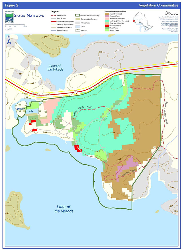
Sioux Narrows Provincial Park is located within a transition zone where Great Lakes-St. Lawrence Forest and boreal forest species co-exist. Historically, in Great Lakes - St. Lawrence forests, pines are more dominant tree species based on the soils and climate that are present. However, with logging and changes in fire activity, boreal species are now more abundant than in the past, occurring as pure stands as well as mixed stands combined with Great Lakes St. Lawrence species (Rowe 1972). In general, five major plant communities are represented in Sioux Narrows Provincial Park (OMNR 2006a). They include intolerant hardwood dominated forests (e.g. aspen, birch), mixedwood forests (e.g. red pine and birch); tolerant hardwood forests (e.g. black ash); exposed rock, and open marsh (Figure 2).
Vegetation is best described as representative of the north-south transitional zone between the Great Lakes-St. Lawrence and the boreal forests. Species that have southern affinities are found growing on warmer than normal sites within the park. Such species include white pine, red pine, American elm and bur oak. Other vegetation typical of more southern regions includes smooth sumac, poison ivy and common juniper. Areas exhibiting a more normal local climate are characterized by trembling aspen growing in association with white birch and balsam fir. A small wetland that includes multiple successional stages is present in the western portion of the park (Noble 1977).
The park contains several mature white pine trees, some of which measure greater than 73 centimetres diameter at breast height and are estimated to be more than 100 years old.
7.4 Fauna
Fauna is typical of the Great Lakes-St. Lawrence Forest and also contains elements of the boreal forest. Winter wren, pileated woodpecker, black-backed woodpecker, red squirrel, gray wolf and white-tailed deer are examples of species found within the park. Species lists can be found in the Sioux Narrows Life Science Checksheet (Mosley 2009).
The bald eagle, a species designated as a species of special concern on the Species at Risk (SAR) in Ontario list, is a common breeder in the area outside of the park. Shortjaw cisco, a fish species designated as threatened both provincially and nationally, has been identified in the Sioux Narrows area, however it has not been confirmed inside the park boundary (T. Mosindy, per comm. 2012). The red-necked grebe and bigmouth buffalo are also known to occur in the greater Sioux Narrows area, and while not SAR they are of interest to OMNR based on their provincial or national conservation concern (see Section 14) (OMNR 2010a, OMNR 2010b). The use of the park by these species is not known.
Walleye are abundant in Regina Bay, while other fish species include lake trout, northern pike, small and largemouth bass, black crappie, muskellunge, whitefish, shallow water cisco, and rainbow smelt (T. Mosindy, per comm. 2012). Lake whitefish and shallow water cisco are exhibiting a recent decline in population which corresponds with the invasion of the alien rainbow smelt in the late 1990s (T. Mosindy, per comm. 2012).
Several aquatic species have been identified within the area as introduced species, which include; small and largemouth bass, rainbow smelt, rusty crayfish, papershell crayfish, northern clearwater crayfish and spiny water flea (T. Mosindy, per comm. 2012). Rusty crayfish have affected populations of the northern crayfish, a crayfish native to the Whitefish Bay area.
Finally, there is a notable muskellunge spawning area in Sioux Narrows Provincial Park, located within the western boundary of the park in Willow Bay. Various fishing restrictions (e.g. possession limits) exist for Regina Bay (OMNR 2013).
7.4.1 Earth sciences
Dominated by bare bedrock, the park is situated on moderately broken terrain typical of the Wabigoon Subprovince, Superior Province, of the Canadian Precambrian Shield. The primary geomorphological feature in the park is a thin, discontinuous veneer of stony sand till (glacial sediment or ground moraine) which was deposited during glacial retreat of the North Bay Interstadial.
Soils are generally sandy with pockets of organic materials in the northeastern part of the park, whereas lacustrine clay deposits found on low-lying valley slopes are associated with glacial Lake Agassiz (Kor 1977; Noble 1977). Striae, left during glacial advance from the northeast, can be seen on exposed bedrock in some areas within the park. In addition, dropstones and glacial erratics, large rocks transported and shed from glaciers, can also be found.
7.4.2 Cultural heritage resources
Sioux Narrows Provincial Park is situated in an area rich in cultural history.
The Lake of the Woods area provided productive hunting grounds, wild rice stands and numerous transportation routes, which were the basis of survival for the Cree and Assiniboine (and later the Ojibway) people. Relatively little is known about the cultural affiliations and distribution of the Aboriginal people prior to European contact (Beaudry and Lavender-Sexsmith 1983). A testimony to the area’s rich Aboriginal history is the existence of several Aboriginal communities located in the Lake of the Woods area (Figure 1).
The French and English began to explore and set up fur trade posts in the area after 1700 (Beaudry and Lavender-Sexsmith 1983). Logging, gold mining, prospecting, and commercial fishing provided the impetus for settlement in the Lake of the Woods area in the late 1800s and early to mid-1900s. The construction of Highway 71, linking Kenora and Fort Frances, was a public works effort during the Great Depression. Upon completion in 1936, tourism began to increase in the area. Sioux Narrows – Nestor Falls continues to be a popular vacation destination.
To date there have been no registered archaeological or historical sites located within the boundaries of Sioux Narrows Provincial Park.
7.5 Recreation objective
The park’s recreation objective is:
To continue to provide high-quality day-use and overnight camping opportunities in a manner which considers and minimizes the associated impacts of such activities on the park.
Sioux Narrows Provincial Park provides numerous opportunities for a variety of ecologically compatible high quality recreational activities. The park includes facilities for car camping and day-use as well as opportunities for resting/relaxing, swimming/wading, fishing, hiking, picnicking, bicycling, photography and nature appreciation.
Although the park is officially closed in the winter, some activities do take place in the park by local residents such as: cross country skiing, snowshoeing and hiking (Onyshkewych 2009).
7.6 Heritage appreciation objective
The park’s heritage appreciation objective is:
To provide park visitors with opportunities to learn about the glacial history of Sioux Narrows and northwestern Ontario, the parks' vegetation communities, and cultural heritage themes relevant to the park, should cultural heritage resources be discovered.
Natural heritage education for Sioux Narrows Provincial Park is conducted through self- use facilities, including; a self-guided nature trail and informal interpretive displays in the park office.
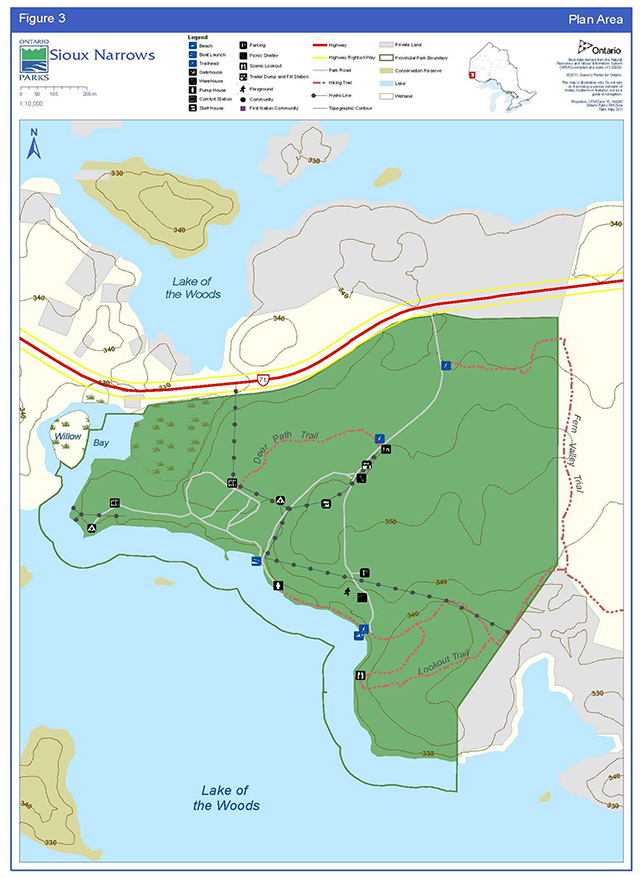
8. Boundary
The boundary area for Sioux Narrows Provincial Park includes all the lands (135 ha) regulated under the PPCRA as Sioux Narrows Provincial Park (Figure 3). The park boundary extends 91.44 metres (m) (300 feet (ft.)) into Lake of the Woods to include that portion of the lake bed.
Within the regulated park boundary, the protection of park values will be achieved through appropriate zoning, the control of land use and activities, education, and monitoring of ecological impacts (see Section 10).
Additions to the park will be considered if the property is needed to enhance the values of the park. Potential acquisitions are subject to available resources and the willingness of the owners to sell or lease their properties or enter into a conservation easement.
9. Adjacent land uses
A mix of Crown and private land surrounds the park. Parcels of privately owned land are located adjacent to the park in the southeast, with two patent mining claims to the north across Highway 71. Crown lands adjacent to the park are within the Kenora Forest Management Unit (FMU).
Sioux Narrows Provincial Park is within trapline area (KE119), and an active bait harvest area (KE0021).
Part of the Fern Valley Trail is located outside the park boundary on adjacent Crown land. It links to the Aspen Trail which is maintained by the Municipality of Sioux Narrows-Nestor Falls (Figure 3) (see Section 9.4.4 Trails). For operational reasons and to protect and enhance the recreational opportunities that the Fern Valley Trail provides, the portion outside the park boundary may be considered for addition to the park through a future land use planning process, subject to consultation.
The Lake of the Woods area is a very popular summer vacation destination. The area surrounding Sioux Narrows Provincial Park contains numerous resorts, and privately owned cottages. The City of Kenora’s recent Economic Development Plan (2012) aims to make the area into a prime destination for boating and sailing.
Naotkamegwanning (Whitefish Bay) First Nation is located approximately five kilometres from the park (Figure 1).
Two local Ontario Federation of Snowmobile Clubs trails exist near the park. The closest trail to the park crosses Willow Bay in the park’s far west, while the second trail traverses Regina Bay, south of the park on Lake of the Woods.
Figure 2: Vegetation communities
Enlarge figure 2: Vegetation communities
10. Park policies
The following policies apply to the whole park.
10.1 Industrial and commercial uses
The following industrial activities are prohibited in Sioux Narrows Provincial Park according to the PPCRA:
- commercial timber harvest
- prospecting, staking of mining claims, developing mineral interests, working mines
- extracting aggregate, topsoil or peat
- generation of electricity
- other industrial uses
The following commercial activities are prohibited in Sioux Narrows Provincial Park in accordance with the Ontario Provincial Parks: Planning and Management Policies (OMNR 1992);
- trapping
- bait harvesting
- bear management area(s) (BMA)
10.2 Adaptive management
An adaptive management approach will be applied to resource management activities within Sioux Narrows Provincial Park. The main premise behind adaptive management is that ecosystems, including protected area ecosystems, are complex and dynamic. Our understanding of these ecosystems and our ability to predict how they will respond to our management actions is very limited. These knowledge gaps lead to uncertainty over how best to manage our parks and protected areas to meet the obligation of maintaining ecological integrity.
This can be done through the careful consideration and implementation of management prescriptions within a protected area, to be used as treatments in the adaptive management framework.
Implementing an adaptive management approach allows researchers to design robust experiments to evaluate management options and provide park managers with directly relevant and scientifically defensible information to help them make management decisions (Kingston and Mosley 2007).
10.3 Resource management policies
Planning and management decisions are intended to ensure the ecological integrity of protected areas. Consideration will also be given to social and economic components. Ontario Parks will ensure that these decisions are made with the best available information. Where this information is lacking, Ontario Parks may conduct research, inventories and monitoring, as necessary, to provide this information. Such efforts will be undertaken based on established methodologies and best practices and will foster an adaptive management approach.
Sioux Narrows Provincial Park will be managed in accordance with the PPCRA and policies set out in Ontario Provincial Parks: Planning and Management Policies for recreational class parks. The following policies will guide the management of park resources consistent with the PPCRA, the Endangered Species Act, 2007 (ESA), and with the requirements of the Environmental Assessment Act, 1990 (EAA). Resource management projects and activities will be undertaken consistent with the Class EAPPCR, where applicable.
For greater certainty, nothing in this plan shall be construed so as to abrogate or derogate from the protection provided for the existing aboriginal or treaty rights of the aboriginal peoples of Canada as recognized and affirmed in section 35 of the Constitution Act, 1982 (2007, c. 6, s. 46).
10.3.1 Land management
Management of the Sioux Narrows Provincial Park land base will be directed towards maintaining the park’s natural landscape and protecting its ecological integrity.
A right-of-way for an electricity distribution line, under authority of a land use permit, enters the park from Highway 71 and exits the park to the east of the day-use area to serve properties beyond park boundaries. A local distribution line enters the park from across Willow Bay in the west and serves the western comfort station (Section 9.3.7).
Comfort station waste generated from campground use will be disposed of using Ministry of the Environment approved septic systems.
No private recreation camps, boat caches or commercial tourism operations exist within Sioux Narrows Provincial Park. No new private, non-commercial or commercial dispositions or outright sale of park land are permitted.
Figure 3: Plan area
10.3.2 Water management
The health and integrity of ecological communities, existing within aquatic areas, will be given priority when assessing feasibility and potential negative effects of any new developments or activities.
Drinking and bathing beach water sampling and testing will be carried out in compliance with:
- the Safe Drinking Water Act, 2002 and associated regulations; and th
- Ontario Beach Monitoring Protocol.
Planning for the replacement of the park’s water treatment plant started in 2010.
10.3.3 Alien and invasive species
Ontario’s Biodiversity Strategy defines alien species (also referred to as introduced, non-native or exotic species) as ³plants, animals and micro-organisms that have been accidentally or deliberately introduced into areas beyond their normal rangeµ. Alien species will not be deliberately introduced into Sioux Narrows Provincial Park (Ontario Biodiversity Council 2011).
There are several common alien species (e.g., dandelion) established in the park, mostly occurring in disturbed areas, however none are known to currently threaten natural or cultural values. Section 9.3.12, identifies the monitoring efforts in place within the park.
Where possible, actions will be taken to eliminate or reduce the threat of invasive species which may be affecting naturally occurring populations. Where alien invasive species are already established and threaten natural or cultural values, a control program may be undertaken if feasible and practical.
10.3.4 Insects and diseases
Native insects and disease are a natural and integral part of the ecology of Sioux Narrows Provincial Park that will normally be allowed to fulfill their ecological role. In exceptional circumstances, control measures will be considered if values of the park are threatened. Insect and disease control measures for alien, and in some extreme cases native species, will be considered if the values, including the ecological integrity of the park are threatened.
Forest insect and disease infestations may be monitored, assessed and treated in the campground for aesthetic and safety reasons. In extreme cases, treatment may take place to minimize effects of insects and disease on campground aesthetics.
Monitoring and research activities pertaining to insects and disease within the park are encouraged, based on available funding (see Section 9.3.11).
10.3.5 Forest fire management
According to the Natural Fire Regimes in Ontario (Van Sleeuwen 2006), Sioux Narrows Provincial Park is located within the Boreal West Forest Region where fire is a major disturbance.
The park contains two dominant vegetation types; aspen dominated communities, and intolerant hardwood with mixed conifers, both of which are variable in terms of fire regimes. Fires in aspen dominated communities, with no human intervention, can range from low to high intensity, dependant on the amount of fuel available on the forest floor. Fires are more common during spring and fall when there is an abundance of leaf litter and dry fuel (Van Sleeuwen 2006).
Fires in lowland hardwood forests can vary dramatically between relatively infrequent to very frequent stand replacing or understory fires. Adjacent ecosystems strongly influence this forest type in terms of fire, insect, disease, blowdown and drought. Most lowland fires would have occurred during drought conditions during late summer months (Van Sleeuwen 2009).
The Forest Fire Management Strategy for Ontario (OMNR 2004) (under review) provides strategic direction for the management of forest fires across Ontario. Sioux Narrows Provincial Park is in the Boreal Fire Management Zone. According to this provincial strategy, this zone has a high level of protection, with fires generally receiving aggressive initial attack and sustained action until extinguished.
10.4 Fire response
The parks proximity to the Highway 71 corridor and the community of Sioux Narrows makes it impractical to allow forest fires to function freely, without putting values within and adjacent to the park, at risk. As a result, forest fires in the park will be suppressed and response options such as modified response or monitoring will not be used. ³Light on the landµ fire suppression techniques will be used whenever feasible. These minimal impact suppression techniques do not unduly disturb natural or cultural values.
The response for structural fires and forest fires is guided by an informal agreement between the MNR and the Township of Sioux Narrows - Nestor Falls. Fire evacuation procedures will be outlined in the Fire Emergency and Evacuation Plan for Sioux Narrows Provincial Park.
10.5 Fire use
Prescribed burning may be used to maintain naturally occurring vegetation communities in the park or to reduce fire hazards. Any prescribed burns will be planned and executed in accordance with the Prescribed Burning Operations Policy (OMNR 2011b), with the cooperation of the Aviation, Forest Fires and Emergency Services Branch’s (AFFES) Planning and Information Management Team and the Kenora Fire Management Headquarters.
10.6 Additional fire direction
Partial or total fire bans may be put in place and enforced at the discretion of the park superintendent following consultation with AFFES staff and the local municipal fire department.
Consistent with the FireSmart principles, a forest fire hazard identification and risk assessment will be completed for park infrastructure and steps will be taken to reduce or mitigate the threat to infrastructure posed by fire.
Fuel caches for purposes other than use by park staff during regular operation and maintenance activities are not permitted in the park.
10.6.1 Species at Risk (SAR)
SAR and their habitats will be protected in a manner consistent with the ESA and associated regulations.
The only known SAR in the vicinity of Sioux Narrows Provincial Park is the bald eagle, which has been listed as a species of "special concern" in northern Ontario under the ESA. Shortjaw cisco has also been identified in the Whitefish Bay area and is currently designated as "threatened" provincially (ESA) and nationally (Species At Risk Act).
10.6.2 Vegetation management
The park’s vegetation communities are described in Section 6.1.1.2.
Management of the park’s vegetation will be directed towards maintaining and protecting the ecological integrity of the park and to support the evolving natural succession of plant communities.
Vegetation management, landscape management or restoration projects may be undertaken to address impacts of recreation and park use so that ecological integrity is maintained or restored within the park. While maintaining the park’s ecological integrity remains a priority, restoration efforts shall be considered in highly compromised areas, including within the development zone. This may include trail rehabilitation, and the planting of vegetation in the development zone (e.g., campground) to ensure the succession of vegetation.
The removal of hazard trees will be permitted in all zones where safety is a concern (e.g., trails and campground). Underbrush may be cleared around park buildings using FireSmart (Section 9.3.5.3) techniques to mitigate potential fire damage and protect park infrastructure.
Areas experiencing adverse use impacts (e.g. root exposure, trampling, limb cutting and damage from vehicles) will be rehabilitated whenever possible. Should planting or seeding be necessary, species native to the park will be used. Seed sources of these species will originate from the park or a nearby location.
Herbicide applications, including in the hydro corridor, will be discouraged. Insect and disease control measures are found in Section 9.3.4.
Any development that requires the removal of vegetation other than hazard trees will be supported by a vegetation inventory in accordance with approved site plans.
10.6.3 Wildlife management
Management of wildlife in Sioux Narrows Provincial Park will be directed towards maintaining and protecting the park’s ecological integrity. Proposed wildlife management projects and activities may be subject to the Class EA-PPCR.
The Cervid Ecological Framework (OMNR 2009) guides management of cervid species in the park and on the surrounding landscape. American elk and woodland caribou will be monitored and sightings documented, as the park is contained within the Cervid Ecological Zone 'C1' of this framework.
Displaced and nuisance animals (e.g. black bears) may be controlled when essential to human health and safety, the health of the species outside the park or the values for which the park has been established.
Where control is necessary, humane techniques having minimal effects on other components of the parks environment will be used.
Sioux Narrows Provincial Park is within trapline area (KE119). Existing use is permitted to continue indefinitely. Trapping is not known to occur.
10.6.4 Fisheries management
Sioux Narrows Provincial Park contains more than 20 hectares of lake bed within its boundaries (Section 7). The MNR Lake of the Woods Fisheries Assessment Unit monitors the Lake of the Woods fishery and aquatic ecosystem and does so intensively in the Sioux Narrows and Regina Bay portion of the lake. The Sioux Narrows area is popular for angling and has received moderate angling pressure over the years, with slightly higher pressure then the lake-wide average on Lake of the Woods (T. Mosindy, per comm. 2012).
Ontario has adopted a broad, landscape-level approach to fisheries management by creating Fisheries Management Zones (FMZs). These areas have ³similar ecological, physical, social and economic attributes and are intended to delineate areas that are expected to react similarly to external changes, pressures and management actionsµ (OMNR 2012b). Lake of the Woods is included in FMZ 5. At the time of this management plan’s release, a fisheries management plan for FMZ 5 is currently being developed.
Priorities identified by the Fisheries Management Zone Advisory Council for zone 5 and the MNR include; managing for the quality of the walleye fishery, the sustainability of lake trout populations, establishing management objectives for northern pike given current regulations, as well as smallmouth bass and crappie (OMNR 2012b).
Lake trout are now recovering from over exploitation and muskellunge are considered to have a recovered population (T. Mosindy, per comm. 2012).
Ontario Parks encourages the inclusion of parks during broad scale monitoring programs of FMZ 5 as per Ontario’s Ecological Framework for Fisheries Management. Additional monitoring activities for Lake of the Woods, beyond what is carried out during the monitoring of FMZ 5, may be considered, based on need and available funding.
Sioux Narrows Provincial Park is within bait harvest area (KE0021). Existing use is permitted to continue indefinitely. Commercial bait harvesting is not known to occur.
10.6.5 Cultural heritage resources management
Cultural heritage resources include archaeological resources, built heritage resources or cultural heritage landscapes.
The management of cultural heritage resources at Sioux Narrows Provincial Park will be directed towards protection, heritage appreciation and research. Cultural heritage resources that may be impacted by any park projects or activities will be identified and managed (i.e. protected, maintained, and used) in accordance with the Standards and Guidelines for Conservation of Provincial Heritage Properties (Ontario Heritage Act, 1990, Part III.1).
No known cultural heritage or archaeological features exist within the park boundaries.
In the event of a discovery of an archaeological site, Ontario Parks will work with appropriate ministries, relevant institutions or people to identify and assess the significance of the site.
Ontario Parks will consult with nearby Aboriginal communities on matters pertaining to Aboriginal history, any sites found within the park associated with Aboriginal culture, interpretation of Aboriginal history, and appropriate use of cultural artefacts. The precise location of any found Aboriginal cultural sites, including burial sites, will not be disclosed to the public.
The removal of artefacts or destruction of historical features is illegal and is prohibited by the PPCRA (O. Reg. 347/07 s.2 (1)).
10.6.6 Research
MNR encourages scientific research by qualified individuals contributing to the knowledge of natural and cultural history and to environmental management. Ontario Parks will review proposed research to ensure adequate consideration of potential impacts on protected area resources, features, staff and visitors.
Research and monitoring activities require a research authorization letter issued under the Research Authorization for Provincial Parks and Conservation Reserves Policy and must be consistent with Ontario Parks· research and information strategies (Ontario Parks 1997). Research will be subject to development and management policies associated with the park’s classification, unless special permission is given. Research must meet all requirements under applicable provincial and federal legislation, and may require additional permits or approval (e.g. MNR Wildlife Scientific Collector authorization or ESA permits).
Sites altered by research activities or temporary research facilities must be rehabilitated as closely to their previous condition as possible, except where the specific intent of the research activities is disturbance for the purpose of ecological enhancement or restoration.
10.6.7 Inventory and monitoring
A number of management actions are proposed within the management plan to assist in identifying inventory and monitoring needs, including: public input, routine park maintenance activities, staff knowledge and experiences, and environmental scans. In addition, monitoring may be conducted to support the assessment, design and implementation of new and existing developments, projects and activities or as part of monitoring required under the Class EA-PPCR.
Three life science Rapid Assessment Plots were established in the park in 2005. Five additional Ontario Parks Inventory and Monitoring Plots (OPIAM) (McCaul et al. 2008) established in 2009. These plots can be used to observe changes in vegetation communities and ecological integrity over time, as well as monitor breeding birds, other wildlife, and alien species. Additional monitoring plots will be encouraged.
10.7 Recreation management policies
Opportunities to enjoy high quality outdoor experiences available in Sioux Narrows Provincial Park will be encouraged, provided they do not compromise the integrity of the parks natural features. Those activities that are incompatible with the park vision or objectives will be prohibited or restricted.
10.7.1 Hunting
Sport hunting is not permitted in Sioux Narrows Provincial Park consistent with the Fish and Wildlife Conservation Act, 1997 (FWCA).
10.7.2 Recreational fishing
Recreational (sport) fishing is permitted in the waters of Lake of the Woods.
Recreational fishing is one of the most commonly practiced activities in the park. The park supports this activity by providing a boat launch, two docking facilities, and a fish cleaning station.
Recreational fishing is subject to provincial (FWCA) and federal (Fisheries Act) fisheries legislation and regulations as set out in the Ontario Recreational Fishing Regulations Summary. Catch and possession limits vary by area on Lake of the Woods; and there are specific restrictions on species limits for non-Canadian residents (MNR annual publication).
10.7.3 Mechanized travel
Motorized snow vehicles (e.g. snowmobiles) are not permitted in the park.
Recreational all-terrain vehicle (ATV) use is not permitted in the park.
The park superintendent may authorize motorized use to carry out park management and maintenance activities where needed, such as grooming of the Fern Valley Trail for skiing in the NE-1 zone.
Consistent with federal boating regulations, motorized watercraft are not permitted in designated swimming areas. Docking facilities adjacent to the boat launch are available on a first-come first-served basis. An additional dock is reserved on-site for visitors staying at the waterfront group campsite.
10.7.4 Trails
There are three nature trails in Sioux Narrows Provincial Park; the Deer Path Trail (600 m) and the Lookout Trail (1.5 km) and the Fern Valley Trail (1.6 km) (Figure 3). The trail system in the park connects via the Fern Valley Trail to the Aspen Trail, part of a trail system maintained and promoted by the Municipality of Sioux Narrows-Nestor Falls.
The Deer Path Trail, located within the natural environment zone (NE-1), is a walking path linking the park office/gatehouse to the campground area. The Lookout Trail features scenic vistas of Lake of the Woods and is also located within the natural environment zone (NE-1) (Section 10.2.1, Figure 4). The Fern Valley Trail is a 1.6 km all-season trail which begins near the main entrance to the park in the natural environment zone (NE-1). Users could alternatively access this trail from the trailhead located off Dubois Road. Approximately 800 m of this trail are located on Crown land just east of the park. The trail will be identified as a value for forest management planning purposes. Mechanized grooming of the Fern Valley Trail in winter will be permitted (Section 9.4.5).
A travel corridor links the campground and day-use area which is located in the proposed Development Zone (D-1) (Section 10.1.1, Figure 4), and is not considered a nature trail.
Visitor use will continue to be monitored for demand, non-conforming uses, damage, and rehabilitation needs (Section 9.3.7). Updated interpretive signs and/or trail guides may be considered to enhance these facilities.
10.7.5 Other recreational uses
Bicycling is permitted on the main park roads only (Section 10.1.1, Figure 3). Bicycles are not permitted on hiking trails.
Camping is permitted on designated camp-sites in the campground only (D -1 zone). No backcountry camping is permitted in Sioux Narrows Provincial Park.
Hiking, cross country skiing and snowshoeing are permitted on park trails/roads in all park zones. Mechanized grooming for the purposes of cross-country skiing is permitted on the Fern Valley Trail only; no other trails will be mechanically groomed.
Swimming, canoeing, kayaking, recreational fishing, sailing and sail boarding are only permitted in the NE-2 zone, Lake of the Woods. Motorized and non-motorized watercraft are not permitted in the designated swimming area.
Rock climbing is not permitted in the park.
Other recreational uses may be permitted based on park objectives, provincial policies and subject to the Class EA-PPCR, as applicable.
10.7.6 Services for visitors
Food and beverage services, recreation equipment rental and sales, and retail sales will be determined through business planning in conjunction with the Northwest Zone and park operations plans. A store is currently operated out of the park office where Ontario Parks merchandise, firewood, ice and other products are sold.
10.8 Operations policies
A park operations plan will be prepared to provide staff with the necessary direction required to operate the park on a day to day basis. In addition to addressing the operations policies, the plan will include such topics as budget, staffing, maintenance schedules, enforcement, and emergency services. The provisions of the plan will be consistent with the approved Ontario Provincial Parks Minimum Operating Standards, and will be reviewed annually and updated as required.
10.8.1 Natural Heritage Education (NHE)
The goal of the NHE program is to develop visitor awareness and appreciation of Ontario Parks' natural and cultural heritage.
The objectives of the NHE program are to provide basic information in all parks, interpretation on Ontario’s natural and cultural heritage in provincial parks, and outdoor recreation in representative landscapes in Ontario. There are three levels of NHE service in the provincial park’s system: self-use, seasonal activity, and major activity. Sioux Narrows Provincial Park offers a self-use level of service. This level of NHE park service focuses on the provision of general park information, self-use trails (may or may not be interpretive) and/or kiosks and/or displays as funding permits. At Sioux Narrows Provincial Park there is no dedicated NHE staff. Information and interpretation in this parks consists of signs or information kiosks, trail guides, self-guided trails or interpretive displays.
An NHE plan will be developed when or if required and as funds permit. Direction will be taken from provincial policy, the Provincial Natural Heritage Education Plan, and this plan. The scope and intent of all activities will be carefully defined to ensure their compatibility with park features. Once in place, the plan will be reviewed regularly.
10.9 Information
Basic information regarding Sioux Narrows Provincial Park, its resources, and facilities, as well as general information about the local area, camping, and the outdoors is distributed through a variety of means, including: the park office, the Ontario Parks guide, park tabloid, park maps and the Ontario Parks· website.
10.10 Park interpretation
Self-use interpretive facilities will provide park visitors with a greater appreciation for and understanding of the natural features of Sioux Narrows Provincial Park. Printed material, self-use facilities and informal personal contact will be the primary means of interpretation. Formal NHE programs are not typically provided in self-use parks.
Additional public programs and special events are offered at the discretion of the Park Superintendent.
The Lookout Trail has interpretive posts along its path for educating visitors about the park, however the posts are deteriorating. Improvements such as the development of a trail guide or interpretive trail panels may be considered as funding permits. Additional interpretive signage to better inform park visitors about the park and the provincial parks system may also be considered.
10.11 Outdoor recreation programs
NHE staff from nearby Rushing River Provincial Park may conduct outdoor recreation programs at Sioux Narrows Provincial Park as demand warrants and availability permits.
10.12 Marketing and communications policies
Sioux Narrows Provincial Park will be promoted in accordance with the Ontario Parks Marketing Plan 2011-2014 (currently under review) and subsequent plans afterwards.
Any promotional material developed by partner organizations must be reviewed and approved by Ontario Parks prior to distribution.
10.13 Development policies
All development undertaken by Ontario Parks or by partners on its behalf will be subject to the Class EA-PPCR, and will be carried out in accordance with approved site and development plans that meet development standards for provincial parks.
The maintenance of ecological integrity is a guiding principle in park planning and management, and will be considered during any new development. Areas proposed for development will require prior assessment for significant cultural heritage features and natural values, such as SAR, to ensure these sites are suitable for development, and any values are identified and protected at the site.
The construction of new facilities or roads will be directed by approved implementation and site plans and will only be permitted in the development zone. No new facilities will be permitted in the Lake of the Woods Zone (NE-2) (Figure 4).
10.13.1 Internal roads, parking areas, maintenance and administrative areas
Ontario Parks will continue to monitor the quality of road surfaces as well as the performance and standards of the operations and maintenance facilities within the park. Maintenance and general improvements will occur to maintain visitor safety. Upgrading and/or replacement of facilities will occur as required or as funds permit. Realignment and/or upgrading of roads may occur to complement other development needs.
10.13.2 Campground, day-use areas and trails
Ontario Parks will continue to monitor the quality of the day-use area and its facilities.
No new campgrounds or expansions to the existing campground are proposed for Sioux Narrows. Alternative roofed accommodations (e.g., cabins, yurts) may be considered on existing sites in the D-1 Zone (Section 10.1.1) as use warrants and resources become available.
Ontario Parks will continue to assess the viability and sustainability of the current campground and its facilities to ensure sites are in accordance with provincial standards.
The existing water treatment plant will be replaced once planning for it is complete and as funding permits (Section 9.3.2).
Boat launch and docking facilities may be upgraded as funding permits and/or replaced as required. The relocation or expansion of existing facilities may be considered based on funding, need, and demand taking into account ecological integrity and park values (e.g. muskellunge spawning habitat).
A wooden bulkhead/quay adjacent to the boat launch has been removed and replaced with more suitable erosion control measures. Upgrades and maintenance may be considered to ensure its effectiveness.
Development of additional trails may be considered based on need and demand for recreational opportunities or interpretive features. Changes to the existing trails may be considered if they are found to degrade or inhibit ecological values or processes from continuing in a healthy state. New trails or changes to existing trails will be designed to avoid or minimize impacts to natural and cultural values in the park.
11. Zoning and zone management policies
Lands within Sioux Narrows Provincial Park are zoned in accordance with their environmental and cultural values, and their need for protection (Figure 4). Zones differentiate between the sensitivity of natural and cultural values, and the permissible degree of development, recreational uses, and management practices within the park.
The two zoning categories, development and natural environment, and associated permitted activities proposed for Sioux Narrows Provincial Park are based on the Ontario Provincial Parks: Planning and Management Policies (OMNR 1992). Figure 4 shows the extent and boundaries of the proposed zoning designations for Sioux Narrows Provincial Park. A Global Positioning System (GPS) unit is required to accurately identify zone boundaries.
11.1 Development zone
Development zones contain the area(s) of the park that are geared towards the support of intensive day-use and car camping activities.
11.1.1 D-1 – park road, campground & day-use area (19 ha)
The park’s development zone (D-1) is intended to include all areas of existing development including the main park road, campground roads, parking areas and administrative/maintenance facilities.
The main park road includes the right-of-way which is 20 m wide (10 m either side of the centre line) and provides an access corridor to the campground and day-use areas through the natural environment zone. The development zone extends 50 m either side of the centre line for a portion of the road to include associated infrastructure such as the park office.
Facilities include: campsites, some of which are electrically outfitted, a day-use area with playground structure and picnic shelter, a boat launch, docking facilities, fish cleaning building, a trailer dump and fill station, comfort stations, privies, park office, warehouse, staff house, water treatment plant and septic fields (see Figure 3).
Park staff will monitor this zone for common symptoms of overuse such as exposed tree roots, soil compaction, and damage to trees and will implement appropriate actions to address effects.
11.2 Natural environment zones
Natural environment zones include natural landscapes which permit the minimum level of development required to support low-intensity recreational activities.
11.2.1 NE -1 – Sioux Narrows' Forests (96 ha)
This zone allows the natural and aesthetic landscape of the park to exist intact.
Development within this zone consists of two nature trails, one ski trail and interpretive signs. An electricity right-of-way exists in this zone which provides electricity to the park and neighbouring properties east of the park.
All five vegetation classes present in the park are represented within this zone (Section 6.1.1.2).
11.2.1 NE -2 – Lake of the Woods (20 ha)
This zone provides protection for the parks shoreline features, while providing opportunities for recreational activities on Lake of the Woods.
This zone consists of the lake bed and extends into the Lake of the Woods 91.44 m (300 ft.) perpendicular from shore.
Development within this zone consists of a boat launch facility and two docking facilities.
Figure 4: Proposed park zoning
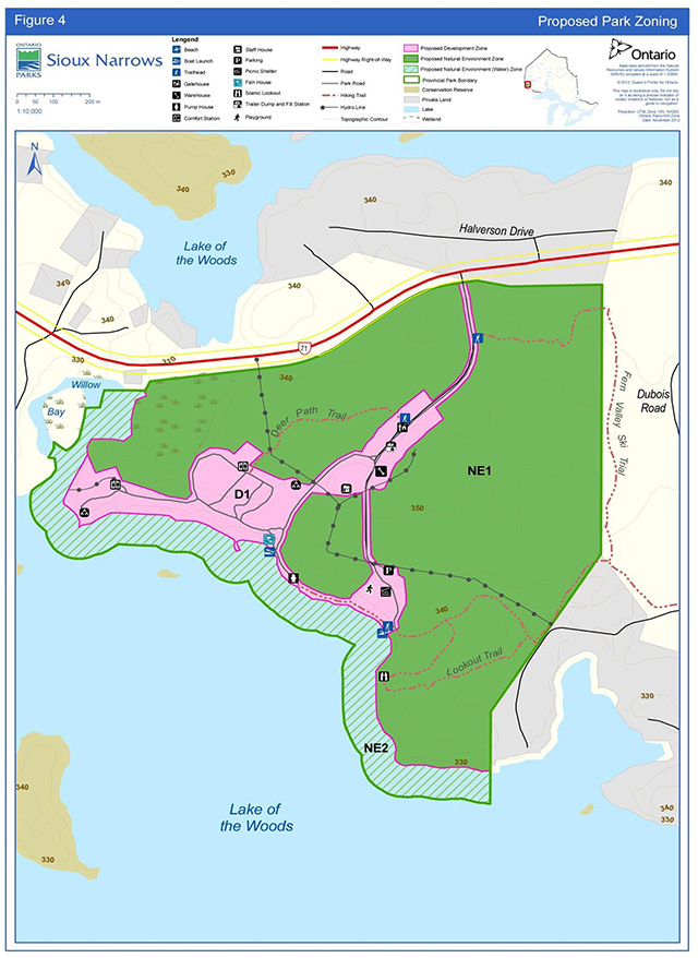
Enlarge figure 4 - Proposed park zoning
12. Implementation priorities
Park development, operations and resource management will be contingent upon the availability of funding and unforeseeable changes in priorities or policy. Implementation of the management plan and operation of the park will meet the requirements of the EAA, EBR, PPCRA, ESA and other pertinent legislation.
All aspects of park management, development and operations will be subject to the Class EA-PPCR.
Park management, development and operations proposals will be phased in as funding is made available and/or as need requires:
- Annual review of the park operating plan
- Ensure the Fern Valley Trail is recorded into Land Information Ontario (LIO)
- Replacement or upgrades to docks, boat launch, privies and playground as required
- Mitigate vegetation damage in campgrounds and alleviate pressures to ensure damage is kept to a minimum, and other campground improvements as necessary
- Vegetation maintenance and/or restoration efforts in areas of the park highly disturbed to maintain/achieve ecological processes and goals
- Replacement of water treatment plant and/or replacement or upgrades to park office
- Road improvements and upgrades
- Update trail signs and/or interpretive guides, monitor use and expand based on demand and available funds
- Preparation of a NHE plan
13. Examination and adjustment of management direction
This plan will be examined after it has been in place for 20 years to determine whether it is still relevant, effective and current or if adjustments are needed. In circumstances where the plan is not providing sufficient direction, or to address specific issues or pressures, it can be examined prior to the next scheduled examination.
External requests for amendments to address specific proposals or needs may be considered. Ontario Parks can provide further guidance on the process for requesting an amendment and whether specific requests can/will be considered
References
Beaudry, M and Lavender-Sexsmith, J. 1983. An historical research report and resource inventory of seven provincial parks in northwestern Ontario. Ontario Ministry of Natural Resources, Northwest Region. 74 pp. (Unpublished Report)
Crins, W.J., Gray, P.A., and Uhlig, P.W.C. 2005. The Ecosystems of Ontario, Part 2: Ecodistricts. Ontario Ministry of Natural Resources. (Unpublished Report)
Crins, W.J. and Kor, P.S.G. 2000. Natural Heritage Gap Analysis Methodologies Used by the Ontario Ministry of Natural Resources (Draft). (Open File Natural Heritage Technical Report 2000-1)
Environmental Assessment Act, R.S.O. 1990, c. E. 18 Note: R.S.O. = Revised Statute of Ontario
Kingston, S.R. and Mosley, E. 2007. Northwest Zone Research Strategy, Ontario Parks, Northwest Zone (2007). Ontario Parks, Thunder Bay. (Unpublished Report)
Kor, P. 1977. Earth Science Inventory Checklist for Sioux Narrows Provincial Park. Ontario Ministry of Natural Resources. (Unpublished Report)
McCaul, E., Kingston, S., and Lawson, A. 2008. Ontario Parks Inventory and Monitoring Program: Guidelines and Methodologies (2008). Ontario Ministry of Natural Resources. (Unpublished Manual)
Mosindy, T., 2012. Personal Communication June 7, 2012. Science and Information Resources Division, Ontario Ministry of Natural Resources. Kenora, Ontario.
Mosley, E. 2009. Sioux Narrows Provincial Park Life Science Checksheet. Ontario Parks, Northwest Zone. (Unpublished Report)
Noble, T. 1977. Life Science Inventory Checksheet for Sioux Narrows Provincial Park. Ontario Ministry of Natural Resources. (Unpublished Report)
Nyberg, J.B. 1998. Statistics and the practice of adaptive management. Pages 1-7 in V. Sit and B. Taylor, editors. Statistical methods for adaptive management studies. British Columbia Ministry of Forests, Research Branch, Victoria, British Columbia, Land Management Handbook 42. [Online] April 27, 2007. Accessed June 7, 2010.
Ontario Biodiversity Council. 2011. Ontario Biodiversity Strategy 2011: Renewing Our Commitment to Protecting what Sustains Us. Ontario Biodiversity Council, Peterborough, Ontario. 69 pp. [Online] URL: http://viewer.zmags.com/publication/c527c66f#/c527c66f/1 Accessed May 22, 2012.
[OMNR] Ontario Ministry of Natural Resources. 1987. Kenora District Fisheries Management Plan. Queen’s Printer for Ontario, Ontario.
[OMNR] Ontario Ministry of Natural Resources. 1992. Ontario Provincial Parks: Planning and Management Policies (1992 Update). Queen’s Printer for Ontario, Toronto. 90 pp
[OMNR] Ontario Ministry of Natural Resources. 1999. July 1999. Ontario’s Living Legacy: Land Use Strategy. Queen’s Printer for Ontario. 136 pp.
[OMNR] Ontario Ministry of Natural Resources. 2004. April 01, 2004. Forest Fire Management Strategy for Ontario’s Queen’s Printer for Ontario, Toronto. 64 pp. [Online] Accessed June 7, 2010.
[OMNR] Ontario Ministry of Natural Resources. 2005. A Class Environmental Assessment for Provincial Parks and Conservation Reserves. Queen’s Printer for Ontario, 120 pp.
[OMNR] Ontario Ministry of Natural Resources. 2006a. Forest Resource Inventory 2006. Digital file.
[OMNR] Ontario Ministry of Natural Resources. 2006b. A Technical Guideline for Cultural Heritage Resources for Projects Planned Under the Class Environmental Assessment for MNR Resource Stewardship and Facility Development Projects and the Class Environmental Assessment for Provincial Parks and Conservation Reserves. (Unpublished Guideline)
[OMNR] Ontario Ministry of Natural Resources. 2009. Cervid Ecological Framework. [Online] June 2009. URL:http://www.mnr.gov.on.ca/stdprodconsume/groups/lr/@mnr/@fw/documents/document/263997.pdf (Link no longer active) Accessed June 7, 2010.
[OMNR] Ontario Ministry of Natural Resources. 2010a. Natural Resources Values Information System. Ontario Ministry of Natural Resources, Kenora. (Unpublished data)
[OMNR] Ontario Ministry of Natural Resources. 2010b. Ontario Natural Heritage Information Centre Species Database. Ministry of Natural Resources, Peterborough. (Unpublished data)
[OMNR] Ontario Ministry of Natural Resources. 2011a. Our Sustainable Future: A Renewed Call to Action; Ministry of Natural Resources Strategic Directions. (Unpublished document)
[OMNR] Ontario Ministry of Natural Resources. 2011b. Prescribed Burning Operations Policy: AFFES:FM:2:10. [Online] URL: http://www.mnr.gov.on.ca/stdprodconsume/groups/lr/@mnr/@affm/documents/document/259390.pdf (Link no longer active) Accessed November 22, 2011.
[OMNR] Ontario Ministry of Natural Resources. 2012a. Biodiversity: It’s In Our Nature. Ontario Government Plan to Conserve Biodiversity, 2012-2020. Queen’s Printer for Ontario. Toronto, ON. 42 pp.
[OMNR] Ontario Ministry of Natural Resources. 2012b. Background Information for the Development of a Fisheries Management Plan in Fisheries Management Zone 5. January 2012.
[OMNR] Ontario Ministry of Natural Resources. 2013. Published Annually. Recreational Fishing Regulations Summary. Queen’s Printer for Ontario.
Ontario Parks. 1997. Research Strategy and Information Strategy: Setting Priorities. Ontario Parks, Planning and Research Section. (Unpublished paper)
Ontario Parks. 2007. Four Year Camping and Day-use Permit Survey – 2006. Ministry of Natural Resources. (Unpublished Report)
Ontario Parks. 2009. Protected Areas Planning Manual. Ministry of Natural Resources. Queen’s Printer for Ontario. [Online] URL: http://www.ontarioparks.com/english/planning_pdf/papm/papm_approved.pdf (Link no longer active)
Onyshkewych, K. 2009. Sioux Narrows Provincial Park (P2611): Recreation Inventory Report. Ontario Parks, Northwest Zone. (Unpublished Report)
Provincial Parks and Conservation Reserves Act, S.O. 2006, c. 12
Note: S.O. = Statute of Ontario
Rowe, J.S. 1972. Forest Regions of Canada. Canadian Forestry Service. (Publication Number 1300)
Van Sleeuwen, M. 2006. Natural Fire Regimes in Ontario. Ontario Ministry of Natural Resources. Queen’s Printer for Ontario, Toronto. 145 pp.
Weyerhaeuser Company Ltd. 2006. Kenora Forest 2006 – 2026 Forest Management Plan. Weyerhaeuser Company Ltd.
14. Species list
Species by common name as mentioned within the document text. Please note: This list is not an exhaustive species list for the park.
14.1 Plant
American elm (Ulmus Americana)
Balsam fir (Abies balsamea)
Bur (or Mossy-cup) oak (Quercus macrocarpa)
Common juniper (Juniperus communis)
Dandelion (Taxaxacum officinale)
Poison ivy (Toxicodendron radicans)
Red pine (Pinus resinosa)
Smooth sumac (Rhus glabra)
Trembling aspen (Populus tremuloides)
White birch (Betula papyrifera)
White pine (Pinus strobus)
14.2 Animal
14.2.1 Bird
Bald eagle (Haliaeetus leucocephalus)
Black-backed woodpecker (Picoides arcticus)
Pileated woodpecker (Dryocopus pileatus)
Red-necked grebe (Podiceps grisegena)
Winter wren (Troglodytes troglodytes)
14.2.2 Crustacean
Northern clearwater crayfish (Orconectes propinquus)
Northern crayfish (Orcenectes virilis)
Papershell crayfish (Orconectes immunis)
Rusty crayfish (Orconectes rusticus)
Spiny water flea (Bythotrephes longimanus)
14.2.3 Fish
Bigmouth buffalo (Ictiobus cyprinellus)
Black crappie (Pomoxis nigromaculatus)
Lake trout (Salvelinus namaycush)
Lake whitefish (Coregonus clupeaformis)
Largemouth bass (Micropterus salmoides)
Muskellunge (Esox masquinongy)
Northern pike (Esox lucius)
Rainbow smelt (Osmerus mordax)
Shallow water cisco (Coregonus artedii)
Shortjaw cisco (Coregonous zenithicus)
Smallmouth bass (Micropterus dolomieui)
Walleye (Sander vitreus vitreus)
14.2.4 Mammal
American elk (Cervus elaphus)
Black bear (Ursus americanus)
Gray wolf (Canis lupus)
Red Squirrel (Tamiasciurus hudsonicus)
White-tailed deer (Odocoileus virginianus)
Woodland caribou (Rangifer tarandus)
52747
0.075k P.R., 13 08 2
ISBN 978-1-4606-3032-7 (Print)
ISBN 978-1-4606-3033-4 (PDF)