Spotted Gar Recovery Strategy
This document is the recovery strategy for Spotted Gar, a species of fish at risk in Ontario.
Spotted Gar (Lepisosteus oculatus) in Ontario
Ontario Recovery Strategy Series

Photo: William Glass
2016
About the Ontario recovery strategy series
This series presents the collection of recovery strategies that are prepared or adopted as advice to the Province of Ontario on the recommended approach to recover species at risk. The Province ensures the preparation of recovery strategies to meet its commitments to recover species at risk under the Endangered Species Act, 2007(ESA) and the Accord for the Protection of Species at Risk in Canada.
What is recovery?
Recovery of species at risk is the process by which the decline of an endangered, threatened, or extirpated species is arrested or reversed, and threats are removed or reduced to improve the likelihood of a species’ persistence in the wild.
What is a recovery strategy?
Under the ESA a recovery strategy provides the best available scientific knowledge on what is required to achieve recovery of a species. A recovery strategy outlines the habitat needs and the threats to the survival and recovery of the species. It also makes recommendations on the objectives for protection and recovery, the approaches to achieve those objectives, and the area that should be considered in the development of a habitat regulation. Sections 11 to 15 of the ESA outline the required content and timelines for developing recovery strategies published in this series.
Recovery strategies are required to be prepared for endangered and threatened species within one or two years respectively of the species being added to the Species at Risk in Ontario list. Recovery strategies are required to be prepared for extirpated species only if reintroduction is considered feasible.
What’s next?
Nine months after the completion of a recovery strategy a government response statement will be published which summarizes the actions that the Government of Ontario intends to take in response to the strategy. The implementation of recovery strategies depends on the continued cooperation and actions of government agencies, individuals, communities, land users, and conservationists.
For more information:
To learn more about species at risk recovery in Ontario, please visit the Ministry of Natural Resources and Forestry Species at Risk webpage at: www.ontario.ca/speciesatrisk
Recommended citation
Ontario Ministry of Natural Resources and Forestry. 2016. Recovery Strategy for the Spotted Gar (Lepisosteus oculatus) in Ontario. Ontario Recovery Strategy Series. Prepared by the Ontario Ministry of Natural Resources and Forestry, Peterborough, Ontario. v + 5 pp. + Appendix viii + 57 pp. Adoption of Recovery Strategy for the Spotted Gar (Lepisosteus oculatus) in Canada (Staton et al. 2012).
Cover illustration: Photo by William Glass
Queen’s Printer for Ontario, 2016
ISBN 978-1-4606-7415-4 (HTML)
ISBN 978-1-4606-3859-0 (PDF)
Content (excluding the cover illustration) may be used without permission, with appropriate credit to the source.
Cette publication hautement spécialisée « Recovery strategies prepared under the Endangered Species Act, 2007 », n’est disponible qu’en anglais en vertu du Règlement 411/97 qui en exempte l’application de la Loi sur les services en français. Pour obtenir de l’aide en français, veuillez communiquer avec recovery.planning@ontario.ca.
Acknowledgments
We thank William Glass of Fisheries and Oceans Canada and Sarah Hogg of Ontario Ministry of Natural Resources and Forestry for providing information that assisted in the development of this recovery strategy.
Declaration
The recovery strategy for the Spotted Gar was developed in accordance with the requirements of the Endangered Species Act, 2007 (ESA). This recovery strategy has been prepared as advice to the Government of Ontario, other responsible jurisdictions and the many different constituencies that may be involved in recovering the species.
The recovery strategy does not necessarily represent the views of all of the individuals who provided advice or contributed to its preparation, or the official positions of the organizations with which the individuals are associated.
The goals, objectives and recovery approaches identified in the strategy are based on the best available knowledge and are subject to revision as new information becomes available. Implementation of this strategy is subject to appropriations, priorities and budgetary constraints of the participating jurisdictions and organizations.
Success in the recovery of this species depends on the commitment and cooperation of many different constituencies that will be involved in implementing the directions set out in this strategy.
Responsible jurisdictions
Ontario Ministry of Natural Resources and Forestry
Fisheries and Oceans Canada
Parks Canada Agency
Executive summary
The Endangered Species Act, 2007 (ESA) requires the Minister of Natural Resources and Forestry to ensure recovery strategies are prepared for all species listed as endangered or threatened on the Species at Risk in Ontario (SARO) List. Under the ESA, a recovery strategy may incorporate all or part of an existing plan that relates to the species.
The Spotted Gar (Lepisosteus oculatus) is listed as threatened on the SARO List. The species is also listed as threatened under the federal Species at Risk Act (SARA). Fisheries and Oceans Canada prepared the Recovery Strategy for the Spotted Gar (Lepisosteus oculatus) in Canada in 2012 to meet its requirements under the SARA. This recovery strategy is hereby adopted under the ESA. With the additions indicated below, the enclosed strategy meets all of the content requirements outlined in the ESA.
Section 1.3 of the federal recovery strategy for the Spotted Gar (Appendix 1) provides a description of the populations and distribution of Spotted Gar in Ontario. However, additional survey efforts have resulted in new records of Spotted Gar which occur outside the federally designated critical habitat. A summary of the new capture locations are as follows:
- Rondeau Bay tributaries: Mill Creek, Flat Creek, Wood Drain, McLeans Drain and Indian Creek;
- Muddy Creek (located between Point Pelee and Wheatley Provincial Park);
- Long Point Bay (located between Port Rowan and Turkey Point); and
- Turkey Point Marsh.
Environmental DNA studies also detected Spotted Gar in a tributary to the lower Thames River (Jeanette’s Creek) and in Cootes Paradise; however, subsequent efforts with traditional sampling methods failed to detect the species.
Genetic analyses conducted by W. Glass and co-workers in 2015 have found that Ontario has several distinct populations of Spotted Gar with low levels of inferred gene flow between them.
The Critical Habitat section of the federal recovery strategy provides an identification of critical habitat (as defined under the SARA). Identification of critical habitat is not a component of a recovery strategy prepared under the ESA. However, it is recommended that the approach used to identify critical habitat in the federal recovery strategy be considered when developing a habitat regulation under the ESA. In addition, the new capture locations noted above should also be considered in developing a habitat regulation for this species.
Adoption of Federal recovery strategy
The Endangered Species Act, 2007 (ESA) requires the Minister of Natural Resources and Forestry to ensure recovery strategies are prepared for all species listed as endangered or threatened on the Species at Risk in Ontario (SARO) List. Under the ESA, a recovery strategy may incorporate all or part of an existing plan that relates to the species.
The Spotted Gar (Lepisosteus oculatus) is listed as threatened on the SARO List. The species is also listed as threatened under the federal Species at Risk Act (SARA). Fisheries and Oceans Canada prepared the Recovery Strategy for the Spotted Gar (Lepisosteus oculatus) in Canada in 2012 to meet its requirements under the SARA. This recovery strategy is hereby adopted under the ESA. With the additions indicated below, the enclosed strategy meets all of the content requirements outlined in the ESA.
Species assessment and classification
Common Name (population): Spotted Gar
Scientific Name: Lepisosteus oculatus
SARO List Classification: Threatened
SARO List History: Threatened (2008), Threatened – Not regulated (2004)
COSEWIC Assessment History: Endangered (2015), Threatened ( 2005, 2000), Special Concern (1994, 1983)
SARA Schedule 1: Threatened (2003)
Conservation Status Rankings: GRANK: G5, NRANK: N1, SRANK: S1
The glossary provides definitions for technical terms, including the abbreviations above.
Genetic analyses suggest that Ontario has several distinct populations of Spotted Gar with low levels of inferred gene flow between them (Glass et al. 2015).
Distribution, abundance and population trends
The “Populations and distribution” section of the federal recovery strategy for the Spotted Gar (Appendix 1) provides a description of the populations and distribution of Spotted Gar in Ontario. However, additional survey efforts have resulted in new records of Spotted Gar which occur outside the identified critical habitat. Although these records are in the vicinity of known Spotted Gar populations, they include occurrences within creeks and drains, where Spotted Gar was not previously known to occur. There is evidence that some individuals travel up these tributaries to spawn, and that they provide habitat for juvenile Spotted Gar (Glass pers. comm. 2014) upstream to the first permanent barrier to fish passage.
A summary of the new capture locations are as follows:
- Rondeau Bay tributaries: Mill Creek, Flat Creek, Wood Drain, McLeans Drain and Indian Creek;
- Muddy Creek (located between Point Pelee and Wheatley Provincial Park);
- Long Point Bay (located between Port Rowan and Turkey Point); and
- Turkey Point Marsh.
It is unclear whether the Muddy Creek record represents a transient individual from the Point Pelee population, or a separate population of the species.
A 2012 environmental DNA study also detected Spotted Gar in a tributary to the lower Thames River (Jeanette’s Creek); however, subsequent efforts with traditional fishing methods failed to detect the species (Boothroyd 2013, Glass and Mandrak 2014). The source of this record is currently unclear. In 2013, a positive environmental DNA detection was made in Cootes Paradise; however, follow-up traditional sampling did not detect any individuals.
Area for consideration in developing a habitat regulation
Under the ESA, a recovery strategy must include a recommendation to the Minister of Natural Resources and Forestry on the area that should be considered in developing a habitat regulation. A habitat regulation is a legal instrument that prescribes an area that will be protected as the habitat of the species. The recommendation provided below will be one of many sources considered by the Minister, including information that may become newly available following completion of the recovery strategy, when developing the habitat regulation for this species.
The Critical Habitat section of the federal recovery strategy provides an identification of critical habitat (as defined under the SARA). Identification of critical habitat is not a component of a recovery strategy prepared under the ESA. However, it is recommended that the approach used to identify critical habitat in the federal recovery strategy be considered when developing a habitat regulation under the ESA. The new capture locations noted above, beyond what is currently identified as critical habitat in the federal recovery strategy for the Spotted Gar (Appendix 1), should also be considered in developing a habitat regulation for this species.
Glossary
Committee on the Status of Endangered Wildlife in Canada (COSEWIC): The committee established under section 14 of the Species at Risk Act that is responsible for assessing and classifying species at risk in Canada.
Committee on the Status of Species at Risk in Ontario (COSSARO): The committee established under section 3 of the Endangered Species Act, 2007 that is responsible for assessing and classifying species at risk in Ontario.
Conservation status rank: A rank assigned to a species or ecological community that primarily conveys the degree of rarity of the species or community at the global (G), national (N) or subnational (S) level. These ranks, termed G-rank, N-rank and S-rank, are not legal designations. Ranks are determined by NatureServe and, in the case of Ontario’s S-rank, by Ontario’s Natural Heritage Information Centre. The conservation status of a species or ecosystem is designated by a number from 1 to 5, preceded by the letter G, N or S reflecting the appropriate geographic scale of the assessment. The numbers mean the following:
1 = critically imperilled
2 = imperilled
3 = vulnerable
4 = apparently secure
5 = secure
NR = not yet ranked
Endangered Species Act, 2007 (ESA): The provincial legislation that provides protection to species at risk in Ontario.
Species at Risk Act (SARA): The federal legislation that provides protection to species at risk in Canada. This act establishes Schedule 1 as the legal list of wildlife species at risk. Schedules 2 and 3 contain lists of species that at the time the Act came into force needed to be reassessed. After species on Schedule 2 and 3 are reassessed and found to be at risk, they undergo the SARA listing process to be included in Schedule 1.
Species at Risk in Ontario (SARO) List: The regulation made under section 7 of the Endangered Species Act, 2007 that provides the official status classification of species at risk in Ontario. This list was first published in 2004 as a policy and became a regulation in 2008.
References
Boothroyd, M. 2013. Environmental DNA (eDNA) detection and quantification of Spotted Gar (Lepisosteus oculatus) in Ontario. Honours Thesis. Trent University, Peterborough, ON. vii + 42 pp.
Glass, W. R., pers. comm. 2014. Email correspondence to Sarah Hogg. February 24, 2014. Visiting Fellow. Fisheries and Oceans Canada.
Glass, W.R. and N.E. Mandrak. 2014. Distribution of Spotted Gar (Lepisosteus oculatus) adults and juveniles in the Rondeau Bay, Long Point Bay, and Hamilton Harbour Watersheds. Canadian Manuscript Report of Fisheries and Aquatic Science 3048: iii + 21pp.
Glass, W.R., R.P. Walter, D.D. Heath, N.E. Mandrak, and L.D. Corkum. 2015. Genetic structure and diversity of Spotted Gar (Lepisosteus oculatus) at its northern range edge: implications for conservation. Conservation Genetics 16(4):889-899.
Appendix 1. Recovery Strategy for the Spotted Gar (Lepisosteus oculatus) in Canada
About the Species at Risk Act recovery strategy series
What is the Species at Risk Act (SARA)?
SARA is the Act developed by the federal government as a key contribution to the common national effort to protect and conserve species at risk in Canada. SARA came into force in 2003 and one of its purposes is “to provide for the recovery of wildlife species that are extirpated, endangered or threatened as a result of human activity.”
What is recovery?
In the context of species at risk conservation, recovery is the process by which the decline of an endangered, threatened, or extirpated species is arrested or reversed and threats are removed or reduced to improve the likelihood of the species’ persistence in the wild. A species will be considered recovered when its long-term persistence in the wild has been secured.
What is a recovery strategy?
A recovery strategy is a planning document that identifies what needs to be done to arrest or reverse the decline of a species. It sets goals and objectives and identifies the main areas of activities to be undertaken. Detailed planning is done at the action plan stage.
Recovery strategy development is a commitment of all provinces and territories and of three federal agencies — Environment Canada, Parks Canada Agency, and Fisheries and Oceans Canada — under the Accord for the Protection of Species at Risk. Sections 37—46 of SARA spell out both the required content and the process for developing recovery strategies published in this series.
Depending on the status of the species and when it was assessed, a recovery strategy has to be developed within one to two years after the species is added to the List of Wildlife Species at Risk. Three to four years is allowed for those species that were automatically listed when SARA came into force.
What’s next?
In most cases, one or more action plans will be developed to define and guide implementation of the recovery strategy. Nevertheless, directions set in the recovery strategy are sufficient to begin involving communities, land users, and conservationists in recovery implementation. Cost-effective measures to prevent the reduction or loss of the species should not be postponed for lack of full scientific certainty.
The series
This series presents the recovery strategies prepared or adopted by the federal government under SARA. New documents will be added regularly as species get listed and as strategies are updated.
To learn more
To learn more about the Species at Risk Act and recovery initiatives, please consult the SARA Public Registry.
Recommended citation
Staton, S.K., A.L. Boyko, S.E. Dunn, and M. Burridge. 2012. Recovery strategy for the Spotted Gar (Lepisosteus oculatus) in Canada. Species at Risk Act Recovery Strategy Series. Fisheries and Oceans Canada, Ottawa. vii + 57 p.
Additional copies
Additional copies can be downloaded from the SARA Public Registry.
Cover illustration: © Joseph R. Tomelleri
Également disponible en français sous le titre
«Programme de rétablissement du lépisosté tacheté (Lepisosteus oculatus) au Canada (proposé)»
©Her Majesty the Queen in Right of Canada, represented by the Minister of Fisheries and Oceans, 2012. All rights reserved.
ISBN 978-1-100-21127-5
Cat. no. En3-4/146-2012E-PDF
Content (excluding the illustrations) may be used without permission, with appropriate credit to the source.
Preface
The Spotted Gar is a freshwater fish and is under the responsibility of the federal government. The Minister of Fisheries and Oceans is a “competent minister” for aquatic species under the Species at Risk Act (SARA). Since Spotted Gar has been located in Point Pelee National Park of Canada administered by Parks Canada Agency, the Minister of the Environment is also a “competent minister” under SARA. SARA, Section 37, requires the competent ministers to prepare recovery strategies for listed Extirpated, Endangered and Threatened species. The Spotted Gar was listed as Threatened under SARA in May 2005. The development of this recovery strategy was led by Fisheries and Oceans Canada — Central and Arctic Region in cooperation and consultation with many individuals, organizations and government agencies, as indicated below. The strategy meets SARA requirements in terms of content and process (Sections 39-41). It was developed in cooperation or consultation with the following (see Appendix 1 for a full record of consultations), as appropriate:
Jurisdictions - Province of Ontario, Environment Canada (CWS), Parks Canada Agency; Environmental non-government groups — Essex Region Conservation Authority, University of Windsor, Trent University; Aboriginal organizations.
Success in the recovery of this species depends on the commitment and cooperation of different constituencies that will be involved in implementing the directions set out in this strategy and will not be achieved by Fisheries and Oceans Canada and Parks Canada Agency or any other party alone. This strategy provides advice to jurisdictions and organizations that may be involved or wish to become involved in the recovery of the species. In accordance with the National Accord for the Protection of Species at Risk, the Minister of Fisheries and Oceans and the Minister of the Environment invite all responsible jurisdictions and Canadians to join Fisheries and Oceans Canada and Parks Canada Agency in supporting and implementing this strategy for the benefit of the Spotted Gar and Canadian society as a whole. Fisheries and Oceans Canada and Parks Canada Agency will support implementation of this strategy to the extent possible, given available resources and their responsibility for species at risk conservation.
The goals, objectives and recovery approaches identified in the strategy are based on the best available knowledge and are subject to modifications as new information becomes available. The competent ministers will report on progress within five years of the publication of this document.
This strategy will be complemented by one or more action plans that will provide details on specific recovery measures to be taken to support conservation of this species. The competent ministers will take steps to ensure that, to the extent possible, Canadians interested in or affected by these measures will be consulted.
Responsible jurisdictions
Under the Species at Risk Act, the Minister of Fisheries and Oceans Canada is the competent minister for all Spotted Gar except those occurring in or on lands administered by the Parks Canada Agency. The Minister of the Environment, responsible for the Parks Canada Agency, is the competent minister for individuals located within Point Pelee National Park.
Authours
This document was prepared by Shawn K. Staton, Amy L. Boyko, Shelly E. Dunn, and Mary Burridge on behalf of Fisheries and Oceans Canada and Parks Canada Agency.
Acknowledgements
Fisheries and Oceans Canada and Parks Canada Agency would like to thank the following organizations for their support of the Ontario Freshwater Fish Recovery Team in the development of the Spotted Gar recovery strategy: Ontario Ministry of Natural Resources, Essex Region Conservation Authority, University of Windsor and Trent University. The authors would like to thank Erling Holm of the Royal Ontario Museum for the use of photographs showing identification features. The authors would also like to thank Sandy Dobbyn for assisting with critical habitat identification in Rondeau Provincial Park. Mapping was produced by Carolyn Bakelaar (GIS analyst, DFO) and Marie Archambault (Critical Habitat Assistant, Parks Canada Agency - Point Pelee National Park).
Strategic environmental assessment
In accordance with the Cabinet Directive on the Environmental Assessment of Policy, Plan and Program Proposals, the purpose of a Strategic Environmental Assessment (SEA) is to incorporate environmental considerations into the development of public policies, plans, and program proposals to support environmentally-sound decision making.
Recovery planning is intended to benefit species at risk and biodiversity. However, it is recognized that strategies may also inadvertently lead to environmental effects beyond the intended benefits. The planning process based on national guidelines directly incorporates consideration of all environmental effects, with a particular focus on possible impacts on non-target species or habitats.
This recovery strategy will benefit the environment by promoting the recovery of the Spotted Gar. The potential for the strategy to inadvertently lead to adverse effects on other species was considered. In cases where critical habitats of multiple species occur, a multi-species approach to the management of habitat is required to maximize benefit to co-occurring species at risk. Such an approach recognizes that negative impacts to some species and their habitats may result from habitat management practices aimed at achieving an overall net benefit to the ecosystem and the species at risk that it supports. The SEA concluded that a multi-species approach will benefit the environment overall and minimize any adverse effects (See: Description of the Species’ Habitat and Biological Needs, Ecological Role, and Limiting Factors; Effects on Other Species; and Approaches Recommended to Meet Recovery Objectives.).
Residence
SARA defines residence as: “a dwelling-place, such as a den, nest or other similar area or place, that is occupied or habitually occupied by one or more individuals during all or part of their life cycles, including breeding, rearing, staging, wintering, feeding or hibernating” [SARA S2(1)].
The residence concept is interpreted by DFO as being constructed by the organism. In this context, Spotted Gar do not construct residences during their life cycle and therefore the concept does not apply (Bouvier and Mandrak 2010).
Executive summary
The Spotted Gar is a relatively large (up to 760 mm in total length), heavily armoured, predatory species with a long, narrow body and elongated snout with many sharp teeth. The back and upper sides are olive green to velvety brown above the lateral line, dull silvery below, and adults have brown spots on the snout, head, body and fins. The Spotted Gar is distinguished from the more common Longnose Gar by its shorter, wider snout. Although globally secure, the Spotted Gar is at the northern extent of its range in southern Ontario and was never common. Extant populations occur within three shallow, heavily vegetated coastal wetlands of Lake Erie (Long Point Bay, Point Pelee National Park and Rondeau Bay). Additionally, new records exist for East Lake and Hamilton Harbour (Lake Ontario drainage); however, it is not known whether reproducing populations exist at these locations as only one individual has been confirmed from each location (in 2007 and 2010, respectively). Historic records of Spotted Gar include single specimens from both Lake St. Clair and the Bay of Quinte (Lake Ontario). Threats to Spotted Gar populations include overall habitat loss (due to dredging, filling and harbour improvements), sediment and nutrient loading, exotic species, barriers restricting movement, climate change and possibly fishing pressure (commercial/recreational incidental harvest).
The Spotted Gar is listed as a Threatened species under the federal Species at Risk Act. As such, the Act requires that a recovery strategy be developed to identify approaches required to arrest or reverse the species’ decline. Fisheries and Oceans Canada and Parks Canada Agency, in cooperation with the government of Ontario, Environment Canada (Canadian Wildlife Service) and other partners, have developed a recovery strategy to facilitate the protection and recovery of this species.
The long-term recovery goal (greater than 20 years) of this recovery strategy is to protect, enhance and maintain Spotted Gar populations within the three coastal wetlands of Lake Erie, where extant populations occur. The following short/medium-term recovery objectives will be addressed over a 5-10 year period to assist with meeting the long-term goal:
- Refine population and distribution objectives;
- Ensure adequate protection of critical habitat;
- Determine long-term population and habitat trends;
- Identify threats, evaluate their relative impacts, and implement remedial actions as required to reduce their effects;
- Enhance efficiency of recovery efforts;
- Enhance quality and extent of available habitat;
- Improve overall awareness and appreciation of the Spotted Gar and the coastal wetland habitats that support it; and,
- Engage landowners, communities and organizations in stewardship actions that minimize/eliminate identified threats to Spotted Gar and its habitat.
The recovery team has identified several approaches necessary to ensure that recovery objectives for the Spotted Gar are met. These approaches have been organized into three categories and urgent actions are summarized below:
Research and monitoring
- Conduct targeted background surveys at current and historical sites as well as other areas of suitable habitat to determine range, abundance and population size.
- Establish and implement a monitoring program to assess changes in population and habitat characteristics.
- Determine home range size and seasonal habitat needs of each Spotted Gar life-stage.
- Confirm the significance of all threat factors impacting populations.
- Evaluate the degree of connectivity (hydrologic, ecological and genetic) between Spotted Gar populations.
Management and coordination
- Coordinate with recovery teams and stewardship groups, including the Essex-Erie Recovery Team (EERT) and other relevant groups to share knowledge and implement recovery actions.
- Encourage municipalities and other land management groups to protect habitats that are important to Spotted Gar within their jurisdiction (e.g., within Official Plans).
Stewardship, outreach and awareness
- Promote basin-wide stewardship efforts among landowners within watersheds of the occupied coastal wetlands in Lake Erie.
- Facilitate, through existing stewardship initiatives, the implementation of Best Management Practices and encourage the completion and implementation of Environmental Farm Plans and Nutrient Management Plans.
Partial critical habitat descriptions have been developed for Spotted Gar populations in Point Pelee National Park, Long Point Bay/Big Creek National Wildlife Area and Rondeau Bay. A schedule of studies has been developed that outlines necessary steps to further refine the critical habitat descriptions across the species’ range. The schedule of studies will also apply to new locations should established populations be confirmed.
A dual approach to recovery implementation will be taken that combines a multi-species approach complemented by a single-species focus. This will be accomplished through coordinated efforts with relevant groups (e.g., conservation authorities), as well as the EERT and its associated Recovery Implementation Groups. The recovery strategy will be supported by one or more action plans that will be developed within five years of the final strategy being posted on the public registry. The success of recovery actions in meeting recovery objectives will be evaluated through the performance measures provided. The entire recovery strategy will be reported on every five years to evaluate progress and to incorporate new information.
Background
Species assessment information from COSEWIC
Common name: Spotted Gar
Scientific name: Lepisosteus oculatus (Winchell, 1864)
COSEWIC status: Threatened (2005)
Reason for designation: This species has a very limited range in Canada where it is known only from three coastal wetlands in Lake Erie. Although its distribution is likely limited by temperature, some of the shallow vegetated habitats that it requires for all life stages are subject to the impacts of siltation, dredging, filling, aquatic vegetation removal and harbour improvements.
Canadian occurrence: Ontario
COSEWIC status history: Designated Special Concern in April 1983. Status re-examined and confirmed in April 1994. Status re-examined and designated Threatened in November 2000, and in May 2005. Last assessment based on an update status report.
Description
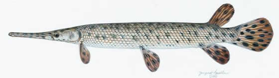
Gars are readily distinguished from other fish species by their long, narrow, armoured bodies and long snouts. The body of the Spotted Gar (Lepisosteus oculatus Winchell, 1864) is heavily armoured with non-overlapping, bony ganoid scales and the snout and jaws are elongated into a relatively broad beak with many sharp teeth (Figure 1). The length of the Spotted Gar’s snout is approximately 40-80% of the head length; the least width is approximately 10-16% of snout length (COSEWIC 2005). The total length (TL) of this species is typically 200 — 600 mm, but it can reach lengths and weights of 1120 mm TL and 2700 g, respectively (Coker et al. 2001). In Canada, the largest specimen recorded measured 767 mm TL and was caught in Rondeau Bay in 2007 (N.E. Mandrak, Fisheries and Oceans Canada [DFO], pers. comm. 2007). The Spotted Gar has a short, deep, caudal peduncle (i.e., point of attachment between the body and the tail). The vertebral column is curved upward in the tail, extending a short way into the upper lobe of the rounded tail. The back and upper sides are olive-green to velvety brown above the lateral line and the colouration is dull silvery below. It has a lateral band with a narrow reddish stripe. Adults have brown spots on the snout, head, body and fins. Juveniles have a fleshy extension of the spine above the upper edge of the tail and are brightly coloured with wide dark brown stripes on the back, sides and belly.
The Spotted Gar is distinguished from the only other native gar species found in Canada, the Longnose Gar (L. osseus), by its shorter, wider snout and a shorter, deeper caudal peduncle (Scott and Crossman 1998) (Figure 2). Since both species are spotted, this characteristic should not be used to distinguish between these two species. Florida Gar (L. platyrhincus) have been found in the Great Lakes basin as a result of presumed aquaria releases. Florida Gar are very similar to Spotted Gar in appearance, but lack the bony, translucent plates on the isthmus between gill openings found on the Spotted Gar (Figure 3) (COSEWIC 2005).
Figure 1. The Spotted Gar (Lepisosteus oculatus).

© Joseph R. Tomelleri.
Figure 2. Differences in snout length and width can be used to distinguish Spotted Gar (bottom) from Longnose Gar .
(Collected in Rondeau Bay, 2002 and modified from COSEWIC 2005).
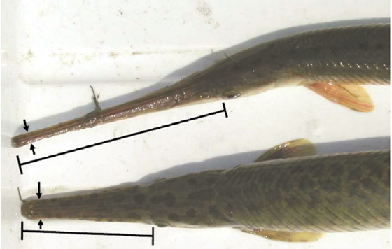
Figure 3. The Spotted Gar (left) can be distinguished from the Florida Gar by the presence of bony plates on the isthmus. Photo by E. Holm, Royal Ontario Museum. 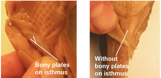
Populations and distribution
Global range and status: The Spotted Gar is only found in North America where it has a wide, but disjunct distribution in the Mississippi, Great Lakes and Gulf Coast drainages of eastern North America, occurring in 18 states and Ontario (Figure 4). In the Great Lakes drainage, the Spotted Gar occurs in Indiana, Michigan, Ohio, Ontario and Pennsylvania (Lee et al. 1980, Page and Burr 1991). In the Mississippi drainage, it is found from Illinois in the north to Alabama and Texas in the south and from Tennessee and Florida in the east to Oklahoma in the west (Lee et al. 1980, Page and Burr 1991). The species is considered globally secure (G5) but is critically imperilled (S1) in Kansas, Ohio and Pennsylvania, and extirpated in New Mexico (NatureServe 2012) (Table 1). Less than 1% of the species’ global range is found in Canada.
Figure 4. Global distribution of the Spotted Gar.
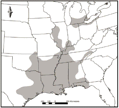
(Modified from Page and Burr (1991))
| Rank level | Rank | Jurisdiction |
|---|---|---|
| Global (G) | G5 (09 Sept. 1996) | |
| National (N) | N1 | Canada |
| N5 | United States | |
| Sub-national (S) | ||
| Canada | S1 | Ontario |
| U.S. | S5 | Alabama, Louisiana, Mississippi, Missouri, Tennessee, Texas |
| S4 | Arkansas, Indiana, Kentucky, Oklahoma | |
| SNR | Florida | |
| S2S3 | Georgia, Illinois, Michigan | |
| S1S2 | Kansas | |
| SX | New Mexico | |
| S1 | Ohio, Pennsylvania |
Canadian range and status: The Spotted Gar is considered imperilled in Canada (N1) and Ontario (S1) (NatureServe 2012), and is designated as Threatened by the Ontario Ministry of Natural Resources (OMNR OMNR 2009). The species is listed on Schedule 1 of Canada’s Species at Risk Act (SARA), and under Ontario’s Endangered Species Act, 2007.
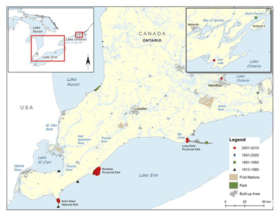
The current range of the Spotted Gar in Canada includes the coastal wetlands of Lake Erie (Point Pelee National Park, Rondeau Bay, Long Point Bay [including Long Point National Wildlife Area (NWA)] and Big Creek NWA), East Lake (an embayment off Lake Ontario and south of Sandbanks Provincial Park) and Hamilton Harbour (Figure 5).
Canadian collections have been made sporadically making it difficult to assess population sizes and trends. The first confirmed captures of Spotted Gar were at Point Pelee National Park in 1913, at Long Point Bay in 1947 and at Rondeau Bay in 1955. Other captures recorded by commercial fishermen in 1925 and 1938 were likely also from Rondeau Bay.
Less than 15 specimens before 2000 have been recorded from these locations in Lake Erie, with one from Point Pelee National Park, one from Inner Long Point Bay, and 11 from Rondeau Bay. However, since 2000, a total of 730 Spotted Gar have been captured at these locations, including 546 specimens from Rondeau Bay (2007-2009), 93 specimens from Point Pelee National Park (2009), and eight specimens from Inner Long Point Bay (B. Glass, University of Windsor [UW], unpublished data).
Spotted Gar have also been detected in two NWAs within the Long Point area: a single record from 1984 exists for the Long Point Unit (located at the tip of the point) of Long Point NWA (J. Robinson, Canadian Wildlife Service [CWS], pers. comm. 2009); and, in 2004, two individuals were recorded from Big Creek NWA (L. Bouvier, DFO, pers. comm. 2010).
Although population sizes are small, and the distribution is limited, the Spotted Gar is considered stable at Lake Erie locations based on available historical and current data (extent of occurrence and abundance data) (EERT 2008).
In May 2007, a single specimen was collected by a commercial fisherman in East Lake. It is believed the same individual was caught multiple times; catches of Spotted Gar ceased after the specimen was provided to the OMNR (J. Bowlby, OMNR, pers. comm. 2009). Beyond these catches, no other individuals have been captured. Intensive sampling was conducted in East Lake in 2008, using gear types proven effective at detecting the species, to verify the presence of a reproducing population; however, sampling failed to detect Spotted Gar (B. Glass, UW, unpublished data). In addition, extensive commercial hoop netting in East Lake has not resulted in any further records of Spotted Gar. Therefore, the reports from a commercial fisherman, potentially of a single individual, remain the only record(s) for East Lake and it is unlikely that a reproducing population exists at this location (Bouvier and Mandrak 2010).
The first verified record of Spotted Gar within the Lake Ontario drainage was a single specimen caught in the Bay of Quinte (North Channel) in 1985. Despite extensive commercial fishing in the area, as well as substantial netting programs conducted by the OMNR, no additional Spotted Gar have been captured and it is possible that this record is the result of an introduction due to its highly disjunct nature.
Additional reports existed for Spotted Gar in Hamilton Harbour that had not been substantiated with voucher specimens until recently, when a single specimen was captured by the OMNR in 2010 (OMNR, unpublished data). Further sampling is required to determine whether a reproducing population exists at this location.
A single specimen was captured in 1962 in Lake St. Clair near the mouth of the Thames River but the species has not been recorded from this area since then, despite relatively extensive sampling conducted by DFO and OMNR.
There are two records of Spotted Gar collected in the Sydenham River from 1975; however, one was thought to be a Longnose Gar by a larval fish expert, and the other lacked a voucher specimen (COSEWIC 2005). Subsequent sampling in 2002 and 2003 by boat electrofishing, fyke netting and seining (N.E. Mandrak, DFO, unpublished data) in the vicinity of the original records, failed to find any Spotted Gar. Hence the original records have been deemed questionable.
Other specimens, reported as Spotted Gar in southwestern Ontario, have either been re-identified as Longnose Gar or voucher specimens were not retained by the collector and identification is, therefore, unconfirmed (COSEWIC 2005).
The distribution of Spotted Gar has always been limited in Canadian waters and, although extensive sampling has recently occurred throughout southwestern Ontario (due to a recent focus on species at risk), no other localities have been recorded for the Spotted Gar. For example, 20 sites at the St. Clair NWA were sampled by DFO in 2005 using fyke nets (a total of 480 hours of effort were expended) and no Spotted Gar were detected (Mandrak et al. 2006a). Populations within the Bay of Quinte and Lake St. Clair (if anomalous records are representative of historic populations), are presumed to be extirpated, based on recent sampling of suitable habitats at these locations (COSEWIC 2005).
Figure 5. Canadian distribution of the Spotted Gar
Needs of the Spotted Gar
Habitat and biological needs
Spawn to embryonic (yolk-sac) stage
Spawning occurs in the spring (May and June), when water temperatures reach 21°-26°C, in shallow water (less than 1 m) containing dense aquatic vegetation, such as marshes and flooded riparian areas (Goodyear et al. 1982, Scott and Crossman 1998, Snedden et al. 1999, Cudmore-Vokey and Minns 2002). In Rondeau Bay, Spotted Gar were observed spawning over aquatic vegetation beds that included milfoil (Myriophyllum sp.) and curly pondweed (Potamogeton crispus) (B. Glass, UW, pers. comm. 2009). The demersal and adhesive fertilized eggs attach to aquatic vegetation and debris in gelatinous masses (Coker et al. 2001, COSEWIC 2005) and hatch within one week (Cudmore-Vokey and Minns 2002). Spotted Gar embryos have an adhesive organ on their snout (Simon and Wallus 1989) and, although capable of swimming, they often hang vertically from aquatic vegetation and other objects. The yolk-sac is absorbed at approximately 17 mm TL or greater — based on a growth rate of 1.3 -1.7 mm/day (Alfaro et al. 2008), and would be absorbed in approximately 10 -13 days.
Larvae (Young of the Year [YOY])
Young-of-the-year remain at the spawning site until their yolk-sacs are absorbed at which point they disperse and begin feeding (Simon and Wallus 1989), remaining in shallow (less than 1 m) littoral zones containing vegetation and substrates of mud, silt and sand (Goodyear et al. 1982).
Juvenile (age 1 until sexual maturity [2-3 yrs males; 3-4 yrs females])
There is no published information on the habitat requirements for juvenile Spotted Gar; however, they are likely to be similar to those of YOY and adults.
Adult
In Canada, adult Spotted Gar are found in the shallow (0-5 m), warm waters of coastal wetlands with abundant vegetation in Lake Erie (Lane et al. 1996); habitat data for the East Lake capture site are not available. In general, the species prefers quiet pools, backwaters and bays with an abundance of aquatic vegetation (Parker and McKee 1984, Page and Burr 1991) or submerged branches (Snedden et al. 1999). Dense vegetation provides necessary camouflage and reduces visibility to potential prey (Coen et al. 1981); as the Spotted Gar is an ambush predator, dense vegetation is critical for its foraging behaviour. Collection sites in Lake Erie had dense vegetation and included water lily (Nuphar sp.), cattails (Typha sp.), Canada waterweed (Elodea canadensis), pondweed (Potamogeton sp.), stonewort (Chara sp.), milfoil, water celery (Vallisneria sp.) and hornwort (Ceratophyllum sp.) (Parker and McKee 1984, B. Glass, UW, pers. comm. 2009). In Oklahoma, Spotted Gar are primarily associated with smartweed (Polygonum sp.), pondweed, milfoil and water-willow (Justicia sp.) (Tyler and Granger 1984). Preferred substrates include silt, clay and sand (Lane et al. 1996). Canadian Spotted Gar capture sites had Secchi depths of 0.3 - >3 m, dissolved oxygen levels of 9-11 mg/L and water temperatures of 15-17°C (in September) (Parker and McKee 1984).
Diel and seasonal movements of the Spotted Gar have been studied in Louisiana by Snedden et al. (1999). Greatest movement occurred as water temperatures and levels rose during the spring. Large home ranges were established in the spring, typically in inundated floodplains, which provided suitable spawning and nursery habitat. Small home ranges were usually established during summer, fall and winter (median 6.6 hectares) (Snedden et al. 1999). However, approximately one third of Spotted Gar tracked, established significantly larger home ranges (median 265 ha) that were usually considerable distances from initial capture sites (Snedden et al. 1999). These new home ranges consisted of seasonally inundated floodplain habitats and heavily vegetated marshes with little or no flow. Except in spring, Spotted Gar is more active at night, which is thought to coincide with their feeding period.
Ecological role
Spotted Gar is one of the most abundant predators in structurally complex shallow water habitats in the southern United States (COSEWIC 2005) and is considered to be a key element of the food web (Snedden et al. 1999); in areas where they are locally abundant (e.g., Rondeau Bay) they may also have a key ecological role. The Spotted Gar is primarily a piscivorous ambush predator that also consumes crayfishes and aquatic insects (COSEWIC 2005). In Ontario, Scott (1967) listed Yellow Perch (Perca flavescens) and minnows (Cyprinidae) as forming a large part of the diet. Since Spotted Gar tends to remain close to the surface, prey species that occupy these areas are more susceptible to predation (Ostrand et al. 2004). Also, as the Spotted Gar is able to inhabit waters with low oxygen levels, it is able to forage in areas where other predators cannot (Burleson et al. 1998, Snedden et al. 1999). Spotted Gar co-occurs with Longnose Gar in Long Point Bay, Point Pelee National Park and Rondeau Bay, but are absent from many suitable habitats in southwestern Ontario where Longnose Gar is abundant (N.E. Mandrak, DFO, unpublished data); further investigation is required to determine the interspecific interactions between these species.
The Spotted Gar is a known host for a freshwater mussel, the Round Pearlshell (Glebula rotundata; a freshwater mussel with a life-cycle that includes an obligate parasite larval stage, usually on a fish host), in the United States (Parker et al. 1984) and, therefore, has the potential to be a freshwater mussel host in Canadian waters. In addition, other species of gar are known hosts for some species of freshwater mussels found in Canada. For example, the Longnose Gar is one host for the Giant Floater (Pyganodon grandis) (D. Woolnough, Trent University, pers. comm. 2007).
Although the eggs of the Spotted Gar were previously thought to be toxic to some species (Scott and Crossman 1998), recent studies have shown that the ichthyotoxin of gar eggs may not act as a protective mechanism from fish predators (Ostrand et al. 1996).
Limiting factors
There are several limiting factors that may influence the recovery potential of the Spotted Gar. Water temperature likely limits the distribution of the species in southwestern Ontario; however, expansion of its range northward may occur under climate warming scenarios (Mandrak 1989). The availability of quiet, backwater areas with dense aquatic vegetation is limited in the waters of southwestern Ontario. Remaining populations are also widely separated and may be isolated. Some of the currently occupied habitats only intermittently provide access to Lake Erie, thus limiting migration and dispersal opportunities. Such isolation could lead to low genetic diversity, low reproductive fitness and inbreeding depression, but this has not been studied.
The recovery potential of Spotted Gar populations may be influenced by factors impacting specific life-stages. Ferrara (2001) studied the life-stages of the Spotted Gar to determine which had the greatest influence on population growth rates. Results suggested that the survival of juvenile Spotted Gar had the highest influence on population growth rate. Therefore, in theory, management actions that enhance the survival of juveniles should result in the largest population growth rate as compared to actions targeting other life-stages.
Threats
Threat classification
All known and suspected threats affecting the Spotted Gar in Canada are listed in order of concern in Table 2. Seven potential threats were ranked based on their expected relative impacts. Where possible, the spatial extent, frequency, causal certainty, and expected severity of the threat has been identified. Overall level of concern is also given for each threat. The threat classification parameters are defined as follows:
- Overall level of concern — composite level of concern regarding the threat to the species, taking into account the four parameters listed below (H/M/L)
- Extent — spatial extent of the threat in the waterbody (widespread/localized);
- Frequency — frequency with which the threat occurs in the waterbody(seasonal/continuous);
- Causal certainty — level of certainty that it is a threat to the species (High — H, Medium — M, Low - L); and,
- Severity — severity of the threat in the waterbody (H/M/L).
| Specific threat | Overall level of concern (high, medium, low) | Extent (widespread/ localized) | Frequency (seasonal/ continuous) | Causal certainty (high, medium, low) | Severity (high, medium, low) |
|---|---|---|---|---|---|
| Habitat modifications | H | W | C | H | H |
| Aquatic vegetation removal | M | W | S | M | Unknown |
| Sediment loadings | H | W | S | H | H |
| Nutrient loadings | H | W | S | H | M |
| Exotic species | M | W | C | M | M |
| Climate change | M | W | C | M | Unknown |
| Barriers to movement | L | L | C | M | Unknown |
| Fishing pressure (incidental harvest) | L | L | Unknown | Unknown | Unknown |
Description of threats
Habitat modifications
Quiet, vegetated, shallow habitats, vital to all stages of the Spotted Gar life-history, are rapidly disappearing, or are being degraded as a result of siltation, dredging, filling and harbour improvements (COSEWIC 2005). Habitat loss can result from shoreline hardening and the construction of in-water and shoreline structures (e.g., piers, groynes, docks) within Spotted Gar habitat. Within Rondeau Harbour, historic losses and degradation of nearshore habitat has occurred where shoreline development resulted in shoreline hardening.
Aquatic vegetation removal: The removal or control of aquatic vegetation is a type of habitat modification that merits special attention due to the importance of aquatic vegetation to Spotted Gar. The physical act of removing aquatic vegetation can be harmful to the species; the mechanical removal of vegetation disturbs sediments and creates turbid conditions; and, vegetation removal using herbicides introduces potentially harmful chemicals into the water. Though large scale aquatic vegetation removal is believed to be a serious threat to the Spotted Gar, the amount of vegetation being removed and the degree to which this may impact the species is unknown.
Historic large-scale, and recent small-scale, vegetation removals conducted in Rondeau Harbour removed Spotted Gar habitat. However, with recent overgrowths of aquatic vegetation in Rondeau Bay (Gilbert et al. 2007), it is possible that limited vegetation removal could benefit the species in such conditions; additional research is required to determine this.
Aquatic vegetation removal is also occurring in the Inner Bay at Long Point, especially within the cottage community channels, where aquatic vegetation is becoming more of a management issue (due to overgrowth). Additionally, the draw seine fishery within Long Point Bay removes aquatic vegetation in the spring to facilitate fishing (J. Robinson, CWS, pers. comm. 2009).
In the Point Pelee area, close to 60% of the historic marshes that once hydrologically connected the existing park with present day Hillman Marsh were drained between the 1890s and 1950s for agricultural use. This likely led to a considerable reduction in the amount of habitat available for the Spotted Gar population within the Point Pelee area (V. McKay, Parks Canada Agency [PCA], pers. comm. 2008).
Sediment loading
Sediment loading affects inland watercourses, coastal wetlands and nearshore habitats by decreasing water clarity, increasing siltation of substrates, and may have a role in the selective transport of pollutants including phosphorus. Sediment loading is often caused by a variety of sources, including poor agricultural and land management practices, improper drain maintenance practices, dredging activities and the removal of riparian vegetation. Increased turbidity as a result of sediment loading, as documented at Point Pelee National Park (H. Surette, University of Guelph, pers. comm. 2007), can limit the ability of the Spotted Gar to feed.Turbidity and siltation can negatively impact species by causing reductions in respiration, vision, prey abundance, as well as smothering their eggs. Siltation from tile drainage has been evidenced in Rondeau Bay, particularly during storm events (Gilbert et al. 2007). Water entering Rondeau Bay from tributaries on the north and west shores is high in nutrients and suspended solid concentrations (including sediment) and has resulted in considerable long-term impacts on the bay, nearshore areas, and riparian wetland habitat (Gilbert et al. 2007).
Nutrient loading
Nutrient loading, which is often associated with sediment loading, has been identified as a primary threat to the three coastal wetlands currently occupied by the Spotted Gar (EERT 2008). Nutrient (nitrates and phosphorus) enrichment of waterways can negatively influence aquatic health through algal blooms and associated reduced dissolved oxygen concentrations. Elevated nutrient (nitrogen and phosphorus) concentrations can impact Spotted Gar populations directly (e.g., altering habitat) or indirectly (e.g., reducing prey abundance). This is particularly evident in Rondeau Bay where nutrient loading from adjacent agriculture and residential areas is negatively impacting wetland habitats (Gilbert et al. 2007). Where nutrient inputs are elevated, vegetation diversity has declined and native species of emergent and submergent wetland vegetation, preferred by Spotted Gar, are outcompeted by cattail and common reed grass (Phragmites australis). Although wetlands are highly valued for their water filtering capacity, these systems are negatively impacted when nutrient (and chemical) concentrations exceed background levels (Gilbert et al. 2007).
Exotic species
Exotic species may affect the Spotted Gar in several different ways including competition for space, habitat, and food, and restructuring of aquatic food webs. There are now at least 182 exotic species known from the Great Lakes (Ricciardi 2006) and some of these species are likely to impact the Spotted Gar or its habitat. The Common Carp (Cyprinus carpio), Round Goby (Neogobius melanostomus), and Zebra and Quagga mussels (Dreissena spp.), are exotic species that have had a dramatic effect on the aquatic community of Lake Erie and will continue to alter/transform ecosystems and ecosystem processes. It should be noted that the establishment of the Zebra Mussel may have improved habitat conditions by improving water clarity which promotes aquatic plant establishment at some locations (Ontario Federation of Anglers and Hunters, 2011). The Round Goby has spread throughout Lake Erie. Beach seining surveys on Pelee Island and along the north shore of Lake Erie in 2005-06 found the Round Goby present at all 34 sites surveyed (Reid and Mandrak 2008). Since Spotted Gar typically feed on fishes near the surface, the shift to a fish community increasingly dominated by Round Goby (a bottom-dwelling species) may negatively impact this species. It is also possible that Round Goby may eat Spotted Gar eggs; the Round Goby is known to eat the eggs of native darter and sculpin species (Fuller et al. 2009). Exotic species such as Common Carp, common reed grass and possibly hybrid cattails are a concern for existing populations of Spotted Gar since these species can cause significant alterations of native wetland habitats.
The exotic Florida Gar has been collected in the Great Lakes basin (likely the result of aquaria releases). This related species could represent an additional threat to the Spotted Gar, either through hybridization or competition, if the species becomes established. There are reports of hybridization where these species overlap in Florida (Lee et al. 1980) and Florida Gar are sometimes available in local aquarium stores.
Climate change
Climate change is expected to have significant effects on aquatic communities of the Great Lakes basin through several mechanisms, including increases in water and air temperatures; changes in water levels (i.e., lowering); shortening of the duration of ice cover; increases in the frequency of extreme weather events; emergence of diseases; and, shifts in predator-prey dynamics (Lemmen and Warren 2004). It is anticipated that the effects of climate change will be widespread and should be considered a contributing impact to species at risk and all habitats. Not all of the effects of climate change will negatively affect species at risk — those species that are limited in their range by cool water temperature, such as the Spotted Gar, may expand their distribution provided that dispersal corridors of suitable habitat are available. However, a suite of reactions related to changes in evaporation patterns, vegetation communities, lower lake levels, increased intensity and frequency of storms, and decreases in summer stream water levels may offset the direct benefits of increased temperatures.
In a recent assessment of the projected impacts of climate change on coastal wetland fish communities in the lower Great Lakes, Doka et al. (2006) predicted several fishes at risk as most vulnerable. Their results showed that the Spotted Gar ranked 5th highest in vulnerability scores of 99 fish species that use lacustrine (lake) habitats. Vulnerabilities were based on an assessment of climate change risk associated with coastal wetland and thermal preferences for different life-stages as well as species’ distributions.
Barriers to movement
Natural or man-made barriers may afford protection for some species from competitors, exotic species and predators. Therefore, any breaches in the barrier could have negative impacts on local fish communities. For example, another fish species at risk, the Lake Chubsucker (Erimyzon sucetta) is found in two diked wetlands where water level management is ongoing (Big Creek NWA and St. Clair NWA); in this instance, it appears as though the dikes are maintaining Lake Chubsucker habitat (Staton et al. 2010). Natural barriers at Point Pelee National Park are breached naturally on occasion; however, breaches may be occurring more frequently as a result of human alterations to the shoreline coastal processes that have increased the rates of coastal erosion (V. McKay, PCA, pers. comm. 2007). Conversely, barriers may prevent access to suitable habitat, lead to fragmentation of populations and limit any rescue effect. In some instances, culverts present a physical or velocity barrier (e.g., perched above the streambed or sized improperly) to fish passage between wetland areas and upstream habitat.
Wetlands with natural or artificially maintained barriers include Point Pelee National Park and Big Creek NWA (Long Point region). Spotted Gar have not been recorded from waterbodies where water level management occurs.
Fishing pressure
Although it is not legal to fish for the Spotted Gar (either commercially or recreationally), the species may still be captured incidentally. The extent to which the Spotted Gar may be affected by such incidental harvest is unknown, but is believed to be low. The potential for incidental harvest as a result of baitfishing, coarse fish spearing, sport fishing and commercial fishing (e.g., trap-netting and draw seining at Long Point) requires further investigation.
Actions already completed or underway
Essex-Erie Recovery Strategy
The Essex-Erie Recovery Team is co-chaired by DFO and the Essex Region Conservation Authority, and receives support from ,many agencies and individuals. The Essex-Erie Recovery Strategy (EERS) is a multi-species recovery strategy that covers 14 fishes at risk, including the Spotted Gar throughout its historic range. The long-term goal of this strategy is “to maintain and restore ecosystem quality and function in the Essex-Erie region to support viable populations of fish species at risk, across their current and former range” (EERT 2008). This recovery program will play a central role in recovering Spotted Gar populations. The EERT has identified the three coastal wetlands in Lake Erie with extant populations as core areas for directing recovery efforts to benefit the Spotted Gar and other high priority fishes. Implementation of this strategy (including stewardship actions to reduce identified threats) is proceeding through the efforts of the recovery team and associated Recovery Implementation Groups (RIGs). In addition, some parks and protected areas have ongoing stewardship and awareness initiatives. At Point Pelee National Park, seasonal programs provide increased awareness of species at risk issues such as habitat loss, contaminants, exotic species and water quality concerns within the park. Similar programs occur at Rondeau Provincial Park. For further details on specific actions currently underway, refer to the approaches identified in Table 6. Funding for many of these actions is supported by the Government of Canada’s Habitat Stewardship Program (HSP) for Species at Risk.
Rondeau Bay aquatic vegetation issues working group
This multi-agency working group was initially formed to provide a forum for the discussion of issues related to aquatic vegetation in Rondeau Bay. There has been growing concern over the past few decades by government agencies and the public over the dramatic fluctuations in the aquatic vegetation community in Rondeau Bay. In recent years, the overgrowth of aquatic vegetation has resulted in increased pressure on regulatory agencies to approve aquatic vegetation removal projects to allow for boat access and recreational uses in the bay. Specifically, the working group will work to ensure that aquatic vegetation removal projects do not negatively impact the Spotted Gar and other species at risk. More broadly, the group will seek to facilitate solutions to balance competing human interests with efforts to protect and improve habitat conditions for fish and wildlife in the bay, with a focus on fishes at risk. The objectives of the group include the promotion and protection of species at risk as well as to provide guidance and support to stewardship initiatives within the Rondeau Bay watershed. Several stewardship groups aimed at improving land use practices and aquatic habitat are currently active within the basin.
Spotted Gar research
A graduate student from the University of Windsor, in cooperation with DFO, has completed a study on age and growth of Spotted Gar (Glass et al. 2011), and is conducting studies (initiated in 2007) on the genetic variation of Spotted Gar and the movements of Spotted Gar within Rondeau Bay (via radio tracking) to determine home range and habitat utilization (N. Mandrak, DFO, pers. comm. 2011).
Awareness — incidental harvest
Although not legal, some incidental harvest of Spotted Gar by commercial fishers is possible at Long Point Bay. An information package has been developed and distributed to commercial fishers that may harvest in occupied wetlands. The information package includes a description and illustration of the species, a map of known areas of occupation and a description of preferred habitats. Fishermen were asked to avoid areas of known occurrence and to report areas of incidental captures. In Point Pelee National Park, fish species at risk information packages were distributed in 2008 and 2009 to all day use and seasonal sport fishers, including an explanatory letter, a DFO fact sheet for the Spotted Gar and other fish species at risk in the marsh and a species report form. Sport fishers were asked not to target these fishes at risk, to release them as quickly as possible if they were caught accidentally and to report their capture to park staff using the form provided (V. McKay, PCA, pers. comm. 2009). Incidental harvest by recreational anglers is also a possibility at Long Point Bay and Rondeau Bay; although, further investigation is required to determine if this is actually occurring and to what degree it is a threat.
Recent surveys
The following table summarizes recent fish surveys conducted by various groups/agencies within areas of known occurrence of the Spotted Gar.
| Waterbody/ general area | Survey description (years of survey effort) |
|---|---|
| Lake St. Clair |
|
| St. Clair NWA |
|
| Lake Erie |
|
| Point Pelee National Park |
|
| Rondeau Bay |
|
| Long Point Bay |
|
| Long Point NWA |
|
| Big Creek and Big Creek NWA |
|
Gear type: a-seine, b-trawl, c-backpack electrofishing unit, d-boat electrofishing unit, e-fyke nets, f-additional gear (trap nets and Windermere traps).
Knowledge gaps
There are numerous aspects regarding the biology, ecology, distribution and abundance of the Spotted Gar that remain unknown. This information is required to refine recovery approaches and to aid in refining critical habitat identification. Information is lacking regarding home range size, habitat use, seasonal movements and connectivity of populations at Point Pelee National Park, Rondeau Bay, Big Creek NWA and Long Point Bay. Primary threats that may be impacting populations have not been fully assessed (e.g., source of threat, extent). Competition with the more abundant Longnose Gar may pose a threat to the Spotted Gar. The association of these two closely related species, as well as the likelihood of Florida Gar becoming established in Canada, need to be further investigated.
Aboriginal traditional knowledge will be sought through consultation and engagement processes to fill knowledge gaps and aid in the conservation of Spotted Gar.
Recovery
The following goals, objectives and recovery approaches were adapted from the Essex-Erie Recovery Strategy (EERT 2008), which includes the three extant populations of Spotted Gar within the coastal wetlands of Lake Erie.
Recovery feasibility
The recovery of the Spotted Gar is considered to be both biologically and technically feasible. The following feasibility criteria1 have been met for the species:
Are individuals capable of reproduction currently available to improve the population growth or population abundance?
Yes. Reproducing populations currently exist within the Canadian range of the species (e.g., Point Pelee National Park and Rondeau Bay).
Is sufficient habitat available to support the species or could it be made available through habitat management or restoration?
Yes. Sufficient habitat appears to be present at one or more locations with extant populations.
Can significant threats to the species or its habitats be avoided or mitigated through recovery actions?
Yes. Significant threats such as sedimentation and nutrient enrichment, increased levels of turbidity and loss of wetland habitat can be mitigated through established restoration methods.
Do the necessary recovery techniques exist and are they demonstrated to be effective?
Yes. Techniques to reduce identified threats (e.g., Best Management Practices [BMPs] to reduce sedimentation and nutrient enrichment) and restore wetland habitats are well known and proven to be effective.
The effort expended to achieve recovery will not be uniform across all populations. Locations with extirpated or reduced populations may require substantial effort to improve habitat and possibly repatriate populations.
Recovery goal
The long-term recovery goal (greater than 20 years) is to protect, enhance and maintain viable Spotted Gar populations within the three coastal wetlands of Lake Erie where extant populations occur.
The present long-term recovery goal is based on current information. If additional extant populations (e.g., East Lake, Hamilton Harbour) of the Spotted Gar are found and/or repatriating an extirpated population is deemed to be feasible, the recovery goal will be revised.
Population and distribution objective(s)
Over the next five year period, the population and distribution objective is to maintain current distributions and densities of extant populations of Spotted Gar in the three coastal wetlands of Lake Erie (Point Pelee National Park, Rondeau Bay and Long Point Bay/Big Creek NWA). More quantifiable objectives relating to individual populations are not possible at this time, but will be developed once the necessary sampling and studies have been completed (Refer to the Schedule of Studies in Section 2.7.5 for anticipated timelines). Such knowledge gaps will be addressed by recovery actions given ‘urgent’ priority that are included in the recovery planning approaches.
Recovery objectives
In support of the long-term goal, the following short/medium-term recovery objectives will be addressed over a 5-10 year period:
- Refine population and distribution objectives;
- Ensure adequate protection of critical habitat;
- Determine long-term population and habitat trends;
- Identify threats, evaluate their relative impacts and implement remedial actions to reduce their effects;
- Enhance efficiency of recovery efforts;
- Enhance quality and extent of available habitat;
- Improve overall awareness and appreciation of the Spotted Gar and the coastal wetland habitats that support it; and,
- Engage landowners, communities and organizations in stewardship actions that minimize/eliminate identified threats to Spotted Gar and its habitat.
Approaches recommended to meet recovery objectives
Recovery planning
The overall approaches recommended to meet the recovery objectives have been organized into three categories represented by the following tables: research and monitoring (Table 4); management and coordination (Table 5); and, stewardship, outreach and awareness (Table 6). Each table presents specific steps with a ranking of priority (urgent, necessary, beneficial), a link to the recovery objectives, a listing of the broad approach, a description of the threat addressed, and suggested outcomes or deliverables to measure progress. A narrative following each table is included when further explanation of specific approaches is warranted. Implementation of the following approaches will be accomplished in coordination with the Essex-Erie Recovery Team (EERT) and its associated implementation groups.
| Priority | Objective(s) addressed | Threats addressed | Broad approach to address threats | Recommended approaches to meet recovery objectives | Outcomes or deliverables (identify measurable targets) | |
|---|---|---|---|---|---|---|
| Urgent | i | All | R1. Background surveys — new/suspected and historic locations | Conduct targeted surveys of preferred habitats at Turkey Point, Tremblay Beach wetlands (mouth of the Thames, Lake St. Clair) and Lake Ontario (Bay of Quinte, Hamilton Harbour, East Lake). | Will determine the presence/absence of the species at these locations. | |
| Urgent | i, iii | All | R2. Background surveys — extant locations | Complete targeted surveys of extant populations. | Will determine health, range, abundance, and population demographics and contribute to the identification of critical habitat. | |
| Urgent | ii, iii | All | R3. Monitoring— populations and habitat | Establish and implement a standardized index population and habitat monitoring program for all extant locations. | Will enable assessments of changes in range, abundance, key demographic characters and changes in habitat features, extent and health. | |
| Urgent | ii | Habitat loss and degradation | R4. Research - habitat requirements | Determine the seasonal habitat needs of all life-stages of the Spotted Gar. These investigations should determine the role that adjacent riparian and terrestrial/semi-aquatic habitat may play in the overall habitat needs of the species. | Will assist with refining the identification of critical habitat for Spotted Gar. Will assist with the development of a habitat model. | |
| Urgent | iv | All | R5. Threat evaluation and mitigation | Confirm the significance of the threat factors that may be impacting extant populations. Identify the primary causes and take steps to mitigate immediate threats based on severity. | Will clarify the severity of specific threats to individual populations and alleviate their impacts. | |
| Urgent | ii | Habitat loss and degradation | R6. Research — home range and habitat use | Conduct radio-tracking studies to monitor habitat use and determine home range size of individuals in the Lake Erie wetlands. | Will assist with refining the identification of critical habitat. | |
| Urgent | iv | Nutrient/ sediment loading | R7. Point source contamination | Identify point sources of nutrient and sediment inputs and their relative effects. | Will assist with the prioritization and direction of on-the-ground recovery efforts. | |
| Urgent | iv | Barriers to movement | R8. Threat evaluation and mitigation — investigate connectivity/ viability | Investigate the degree of connectivity between and within Spotted Gar populations (field surveys/research, genetic analysis) as well as population viability. | Will help to evaluate the severity of the threat and identify mitigation measures, if appropriate/feasible. Population viability analysis will assist in the identification and refinement of critical habitat. | |
| Necessary | iv | Fishing pressure (incidental harvest) | R9. Threat evaluation and mitigation — incidental harvest | Evaluate the impacts of incidental harvest on Spotted Gar populations (e.g., surveys of fishermen). | Will help to evaluate the severity of the threat and identify mitigation or enforcement measures, if appropriate. | |
| Necessary | iv, vi | All | R10. Assessment of watershed-scale stressors | In cooperation with the EERT, assess watershed-scale stressors to occupied coastal wetlands. | Will identify multiple stressors that may affect Spotted Gar populations. | |
| Necessary | iv | Sediment/ nutrient loading, | R11. Water quality monitoring | Measure sediment and nutrient loads (and possibly other contaminants) emitted from streams that are connected to wetlands occupied by the Spotted Gar. | ||
| Necessary | iv | Habitat loss and degradation | R12. Monitoring and enforcement | Continue to monitor, investigate and enforce penalties associated with illegal vegetation removal when it occurs in habitats occupied by the Spotted Gar. To be accomplished in collaboration with the Rondeau Bay Aquatic Vegetation Issues Working Group. | Will reduce vegetation removal threats to populations and create awareness that such areas constitute important habitat. | |
| Necessary | iv | All | R13. Response of Spotted Gar to wetland management practices | Investigate the response of the Spotted Gar to wetland management practices (e.g., Phragmites australis control/management, water level management and other habitat alterations). | Will help to inform future management practices within wetlands containing Spotted Gar. | |
| Beneficial | iv | All | R14.Interspecific interactions | Investigate the relationship between Longnose Gar and Spotted Gar in areas where they coexist. | Will determine what impact, if any, the Longnose Gar has on the Spotted Gar. | |
| Beneficial | iv | Exotic species | R15. Florida Gar risk assessment | Conduct a risk assessment on the probability of Florida Gar becoming established in the Great Lakes basin (i.e., within Spotted Gar habitats). | Will identify the potential for the Florida Gar to impact Spotted Gar populations. Will assist in determining level of threat to the Spotted Gar. | |
| Beneficial | iv | Climate change | R16. Threat evaluation — climate change | Investigate the impacts climate change is having, and will continue to have, on the Spotted Gar and coastal wetland habitats. | Will evaluate the impact of climate change and inform appropriate mitigation measures. | |
Background targeted surveys (R1-R2)
Focused efforts are required to determine the Spotted Gar’s current distribution in areas of extant and historical occurrence as well as directed searches to detect new populations in high probability locations (such as Turkey Point, Hamilton Harbour, East Lake). Sampling methods should be standardized at all sites and include a relevant assessment of habitat characteristics. Recent surveys by DFO have indicated that both active (boat electrofishing) and passive (fyke and trap nets) sampling methods were successful in capturing Spotted Gar in southwestern Ontario (Mandrak et al. 2006b).
Monitoring populations and habitat: (R3)
Monitoring populations and habitat will assist with identifying key habitat requirements needed to identify and refine critical habitat, as well as the implementation of strategies to protect known currently occupied and historically occupied habitats. The monitoring program should be designed to allow for quantitative tracking of changes in population abundance and demographics, analyses of habitat use and availability, and changes in these parameters over time (with regard to known threats). It should also have the ability to detect the presence and abundance of exotic species (e.g., fishes and plants), prey species and other top predators such as the Longnose Gar. The fish monitoring protocol should have regard for the methodologies used in background survey work and provide guidance on the time of sampling and the types of biological samples that should be collected (e.g., fin rays, length and weight).
| Priority | Objective(s) addressed | Threats addressed | Broad approach to address threats | Recommended approaches to meet recovery objectives | Outcomes or deliverables (identify measurable targets) | |
|---|---|---|---|---|---|---|
| Urgent | v | All | C1. Coordination with other recovery teams and relevant groups | Work with the EERT and other relevant groups to share knowledge and implement recovery actions. | Will combine efficiencies, resources, ensure information dissemination, help prioritize the most urgent actions and allow for a coordinated approach to recovery. | |
| Urgent | vi, vii | Habitat loss and degradation | C2. Municipal planning —involvement | Encourage municipalities to protect habitats that are important to the Spotted Gar in their Official Plans and ensure that planning and management agencies are aware of habitats important to the species. | Will assist with the recovery of the Spotted Gar and the protection of important Spotted Gar habitat. | |
| Necessary | vi, vii, viii | Sediment loading; habitat loss and degradation | C3. Relationship building —drainage | Establish good working relationships with drainage supervisors, engineers and contractors to limit the effects of drainage activities on coastal wetland habitats. | Will increase the knowledge and understanding of fish habitat needs and may lead to fewer and/or less harmful alterations. | |
| Necessary | iv, vi | Habitat loss and degradation | C4. Guidelines: dredge, fill and vegetation removal | Ensure that existing guidelines on reducing, mitigating and restoring areas of dredge, fill and vegetation removal impacts take the needs of the Spotted Gar into account. | Will reduce and/or mitigate impacts of dredge, fill, and vegetation removal. | |
| Necessary | v, vii | All | C5. Information sharing- land use planning | Encourage responsible agencies/jurisdictions to integrate recovery team recommendations into planning documents, including land management plans. | Will ensure applicable agencies have timely access to the best information available for integration into planning and land management approaches and processes. | |
| Priority | Objective addressed | Threats addressed | Broad approach to address threats | Recommended approaches to meet recovery objectives | Outcomes or deliverables (identify measurable targets) | |
|---|---|---|---|---|---|---|
| Urgent | v | All | S1. Collaboration and information sharing* | Collaborate with relevant groups, initiatives and recovery teams to address recovery actions of benefit to the Spotted Gar. | Will combine efficiencies in addressing common recovery actions, and ensure information is disseminated in a timely, cooperative fashion. | |
| Urgent | iv, vi, vii, viii | Sediment/ nutrient loading; habitat loss and degradation | S2. Stewardship and habitat initiatives* | Promote stewardship among landowners, First Nations and other interested parties (e.g., anglers) within watersheds of the occupied coastal wetlands, particularly Rondeau Bay. | Will raise community support and awareness of recovery initiatives. Will raise profile of the Spotted Gar and improve awareness of opportunities to improve water quality within coastal wetlands. | |
| Urgent | iv, vii, viii | Sediment/ nutrient loading; habitat loss and degradation | S3. Stewardship -implementation of BMPs* | Work with landowners to implement BMPs in areas where they will provide the most benefit. Encourage the completion and implementation of Environmental Farm Plans (EFPs) and Nutrient Management Plans (NMPs). | Will minimize threats from soil erosion, sedimentation, and nutrient and chemical contamination. | |
| Necessary | vii, viii | All | S4.Communications strategy | Develop and implement a communications strategy that identifies partners, target audiences, approaches, information products, educational and outreach opportunities, stewardship resources and specific BMPs that will assist with the recovery of this species. Should include a focus on awareness of SARA to help ensure compliance with the Act. | Will provide a strategic basis for improving public awareness of species at risk and promote ways in which community and public involvement can be most effectively solicited for the recovery of this species. | |
| Necessary | viii | All | S5. Stewardship —financial assistance/ incentives* | Facilitate access to funding sources for landowner, First Nations and local community groups engaged in stewardship activities. | Will facilitate the implementation of recovery efforts, BMPs associated with water quality improvements, sediment load reduction, etc. | |
| Beneficial | vii | Fishing pressure (incidental harvest) | S6. Awareness —incidental harvest | Provide a Spotted Gar information package to commercial and possibly recreational fishers. Request avoidance of occupied habitats, and the release and reporting of any Spotted Gar captured. | Reduce number of Spotted Gar lost to incidental harvest and build upon monitoring efforts of this species. | |
*Approaches currently being implemented by an ecosystem-based recovery program.
Stewardship and habitat initiatives (S2)
Large-scale efforts to improve the habitat quality of occupied coastal wetland habitats will be required at some locations (such as Rondeau Bay). Emphasis should be placed on improving habitat required for juvenile Spotted Gar as it is believed that this life-stage has the most influence on population growth (Ferrara 2001, Young and Koops 2010). It will be necessary to engage landowners, local communities, First Nations and stewardship councils on the issues of Spotted Gar recovery, ecosystem and environmental health, clean water protection, nutrient management, BMPs, stewardship projects and associated financial incentives. Towards this end, the recovery team will work closely with other relevant groups/agencies and the EERT, which is currently involved with stewardship programs directed towards the improvement of coastal wetlands habitats.
Implementation of BMPs (S3)
The implementation of BMPs will be largely facilitated through established programs of the EERT and associated groups such as Stewardship Kent and the Long Point Region Conservation Authority. To be effective, BMPs should be targeted to address the primary threats affecting currently occupied/critical habitat. BMPs implemented will include those relating to the establishment of riparian buffers, soil conservation, septic improvements to prevent nutrient run-off, herd management, nutrient and manure management and tile drainage within watersheds impacting occupied coastal wetlands. Such BMPs result in reductions in erosion and sediment and nutrient loadings into adjacent watercourses, thereby improving water quality. EFPs prioritize BMP implementation at the level of individual farms and are often a pre-requisite for funding programs. For more information on BMPs, see the Ontario Ministry of Agriculture and Food and Rural Affairs, Best Management Practices Series.
Awareness — incidental harvest (S6)
Although this activity is currently underway (see Section 1.6), additional effort may be warranted. The effectiveness of the awareness program will be monitored and will inform future recovery approaches. Messaging should highlight the value of the Spotted Gar and the important role it plays within local freshwater ecosystems.
Performance measures
The success of implementing the recommended recovery approaches will be evaluated primarily through routine population (distribution and abundance) and habitat (quality and quantity) surveys and monitoring. During the next five years, quantifiable targets will be established for the Spotted Gar. The recovery strategy will be reviewed in five years to evaluate progress made toward short-term and long-term targets, and the current goals and objectives will be reviewed within an adaptive management planning framework with input from the EERT.
The performance measures to evaluate recovery progress in meeting the recovery objectives are presented in Table 7.
| Recovery objective | Performance measures |
|---|---|
| P1. Refine population and distribution objectives. | Refined population and distribution objectives determined by 2015. |
| P2. Ensure adequate protection of critical habitat. | Completion of activities outlined in the Schedule of Studies for the complete identification of critical habitat within the proposed timelines. Critical habitat protected where identified. |
| P3. Determine long-term population and habitat trends. | Monitoring program established by 2015. Current distribution and density of Spotted Gar in three extant Great Lakes coastal wetland populations is maintained or enhanced. |
| P4. Identify threats, evaluate their relative impacts and implement remedial actions to reduce their effects. | Relative significance of threats evaluated by 2014. Initiate implementation of remedial actions to address priority threats by 2015. |
| P5. Enhance efficiency of recovery efforts. | Quantification of BMPs (e.g., number of Nutrient Management Plans and Environmental Farm Plans completed; hectares of riparian zone established) implemented by EERT and other interest groups to address threats within the three occupied Lake Erie coastal wetlands by 2016 (on-going). |
| P6. Enhance quality and extent of available habitat. | Report on habitat improvements as detected by the monitoring program five years after the initial baseline data collected (by 2020). |
| P7. Improve overall awareness and appreciation of the Spotted Gar and the coastal wetland habitats that support it. | Document any changes in public perceptions and support for identified recovery actions through guidance identified in the communications strategy (by 2015). |
| P8. Engage landowners, communities, First Nations and organizations in stewardship actions that minimize/eliminate identified threats to Spotted Gar and its habitat. | Landowners engaged in stewardship actions from 2012-2016. |
1 Draft Policy on the Feasibility of Recovery, Species at Risk Act Policy. January 2005.
Critical Habitat
Identification of the Spotted Gar’s critical habitat
The identification of critical habitat for Threatened and Endangered species (on Schedule 1) is a requirement of the SARA. Once identified, SARA includes provisions to prevent the destruction of critical habitat. Critical habitat is defined under section 2(1) of SARA as:
“…the habitat necessary for the survival or recovery of a listed wildlife species and that is identified as the species’ critical habitat in the recovery strategy or in an action plan for the species”. [s. 2(1)]
SARA defines habitat for aquatic species at risk as:
“… spawning grounds and nursery, rearing, food supply, migration and any other areas on which aquatic species depend directly or indirectly in order to carry out their life processes, or areas where aquatic species formerly occurred and have the potential to be reintroduced.” [s. 2(1)]
For the Spotted Gar, critical habitat has been identified to the extent possible, using the best available information. The critical habitat identified in this recovery strategy describes the geospatial areas that contain the habitat necessary for the survival or recovery of the species. The current areas identified may be insufficient to achieve the population and distribution objectives for the species. As such, a schedule of studies has been included to further refine the description of critical habitat (in terms of its biophysical functions/features/attributes as well as its spatial extent) to support its protection.
Information and methods used to identify critical habitat
Using the best available information, critical habitat has been identified using a "bounding box" approach for the three coastal wetlands where the species presently occurs. This approach requires the use of essential functions, features and attributes for each life-stage of the Spotted Gar to identify patches of critical habitat within the "bounding box", which is defined by occupancy data for the species. Life-stage habitat information is summarized in chart form using available data and studies referred to in Section 1.4.1 (Habitat and biological needs). The "bounding box" approach was the most appropriate given the limited information available for the species and the lack of detailed habitat mapping for these areas. Where habitat information was available (e.g., Ecological Land Classification [ELC], bathymetry data), it was used to inform identification of critical habitat. Specific methods and data used to identify critical habitat (such as the use of ELC) are summarized below (for more detailed information refer to Appendix 2).
Point Pelee National Park
Critical habitat was identified for Spotted Gar within the ponds of Point Pelee National Park using data from the following datasets: Surette (2006), Razavi (2006), A.-M. Cappelli (unpublished data, 2009), and B. Glass (unpublished data, 2009), as well as photographic documentation in 2007 (S. Staton, pers. obs.). Pond names were taken from the National Topographic System (NTS) series of maps.
Rondeau Bay
Datasets from the DFO database for the period from 1955 to 2004, as well as the extensive capture (total of 210 specimens) and tracking data from 2007 (B. Glass, UW, unpublished data) were used in the identification of critical habitat in Rondeau Bay. Within Rondeau Provincial Park, critical habitat was refined using available ELC data for the park. ELC assesses the distribution and groupings of plant species and attempts to understand them according to ecosystem patterns and processes. It also helps to establish patterns among vegetation, soils, geology, landform and climate, at different scales. Using the factors relating to geology, soils, physiography and vegetation, ELC can be used to map vegetation communities at varying organizational scales (Lee et al. 1998, Lee et al. 2001). Spotted Gar capture locations within the park were compared with the park ELC data (Dobbyn and Pasma, in prep.) to determine the wetland vegetation types used by the species. All areas containing these ELC types were initially included as critical habitat; however, aquatic habitats that were isolated from the waters of the bay were excluded as these areas are inaccessible to Spotted Gar.
Long Point Bay/Big Creek NWA
Limited data are available for the Spotted Gar population in Long Point Bay; there are currently 11 records for Spotted Gar in Inner Long Point Bay, the most recent of which is from 2010 (B. Glass, unpublished data). Capture data for Big Creek NWA (connected to Long Point Bay) areas were taken from one location (L. Bouvier, DFO, pers. comm. 2008).
Critical habitat was identified in these areas using ELC, as the wetland (including marsh, meadow marsh, shallow marsh, common reed, floating-leaved and mixed shallow aquatic, and thicket swamp ELC community classes) and aquatic (less than 2 m depths including open aquatic, submerged shallow aquatic, and open-submerged-floating-leaved, mixed ELC community classes) within Big Creek NWA, Inner Long Point Bay and the mouth of Big Creek.
Population Viability
Comparisons of the area of critical habitat identified for each population were made with estimates of the spatial requirements for a minimum sustainable population size. The minimum area for population viability (MAPV) for each life-stage of the Spotted Gar was estimated for populations in Canada (refer to Section 2.7.4). The MAPV is defined as the amount of exclusive and suitable habitat required for a demographically sustainable recovery target based on the concept of a minimum viable population size (MVP) (Vélez-Espino et al. 2008). Therefore, the MAPV is a quantitative metric of critical habitat that can assist with the recovery and management of species at risk (Vélez-Espino et al. 2008). The estimated MVP for adult Spotted Gar is approximately 14 000 individuals and the associated MAPV is estimated to be 35 km², given a 15% chance of a catastrophic event occurring per generation and an extinction threshold of 20 individuals (i.e., the adult population size below which the population is considered extinct). (For more information on the MVP and MAPV values for Spotted Gar refer to Young and Koops [2010].)
MAPV values are somewhat precautionary in that they represent the sum of habitat needs calculated for each life-history stage of the Spotted Gar; these figures do not take into account the potential for overlap in the habitat of the various life-history stages and may overestimate the area required to support an MVP. However, since many of these populations occur in areas of degraded habitat (MAPV assumes habitat quality is optimal), areas larger than the MAPV may be required to support an MVP. In addition, for some populations, it is likely that only a portion of the habitat within that identified as the critical habitat extent would meet the functional requirements of the species’ various life-stages.
Identification of critical habitat: biophysical functions, features and their attributes
There is limited information on the habitat needs for the various life stages of the Spotted Gar. Table 8 summarizes available knowledge on the essential functions, features and attributes for each life-stage (refer to section 1.4.1 Habitat and biological needs for full references). Areas identified as critical habitat must support one or more of these habitat functions.
| Life Stage | Function | Feature(s) | Attribute(s) |
|---|---|---|---|
| Adult and early life stage from spawn to embryonic (yolk sac or < 17mm TL) | Spawning (May to June) Nursery | Coastal wetlands and connected quiet backwater areas along the north shore of Lake Erie: including interconnected flooded riparian areas and contributing channels. |
|
| Larvae (Young of Year > 17mm TL) | Nursery Cover | Coastal wetlands and quiet backwater areas along the north shore of Lake Erie: including interconnected flooded riparian areas and contributing channels. |
|
| Juvenile [age 1 until sexual maturity (2-3 years males; 3-4 years females)] | Feeding Cover | Coastal wetlands and connected quiet backwater areas along the north shore of Lake Erie: including interconnected flooded riparian areas and contributing channels.. |
|
| Adult [from onset of sexual maturity (2-3 yrs for males; 3-4 years for females) and older] | Feeding Cover Migration | Coastal wetlands and connected quiet backwater areas along the north shore of Lake Erie: including interconnected flooded riparian areas and contributing channels. |
|
*where known or supported by existing data
Studies to further refine knowledge on the essential functions, features and attributes for various life-stages of the Spotted Gar are described in Section 2.7.5 (Schedule of studies to identify critical habitat).
Identification of critical habitat: geospatial
Using the best available information, critical habitat has been identified for Spotted Gar populations in the following areas:
- Point Pelee National Park,
- Long Point Bay/Big Creek NWA; and
- Rondeau Bay.
Areas of critical habitat identified at these locations may overlap with critical habitat identified for other co-occurring species at risk (e.g., Lake Chubsucker in Point Pelee National Park, Rondeau Bay and Long Point Bay); however, the specific habitat requirements within these areas may vary by species.
The areas delineated on the following maps (Figures 6-8) represent the area within which critical habitat is found at this time. Using the bounding box approach, critical habitat is not comprised of all areas within the identified boundaries, but only those areas where the specified biophysical features/attributes occur (refer to Table 8). Table 9 below provides the geographic coordinates that situate the boundaries within which critical habitat is found for the Spotted Gar at the three locations; these points are indicated on Figures 6, 7 and 8. Note that permanent anthropogenic structures that are present within the delineated areas (e.g., boardwalks, marinas, pumping stations) are specifically excluded; it is understood that maintenance or replacement of these features may be required at times.
Table 9. Coordinates locating the boundaries within which critical habitat is found for the Spotted Gar at three locations.
| Coordinates Locating Areas of Critical Habitat | ||||
|---|---|---|---|---|
| Location | Point 1 (NW) | Point 2 (NE) | Point 3 (SE) | Point 4 (SW) |
| Point Pelee National Park | 41° 58' 16.130" N 82° 32' 6.518" W | 41° 59' 3.038" N 82° 31' 3.807" W | 41° 58' 24.724" N 82° 30' 11.366" W | 41° 56' 55.374" N 82° 30' 18.126" W |
| Rondeau Bay | 42°18’37.599”N 81°56’58.187”W | 42°21’7.632”N 81°50’12.408”W | 42°15’15.910”N 81°52’28.197”W | 42°15’43.640”N 81°56’16.772”W |
| Long Point Bay/Big Creek NWA | 42°36’1.841”N 80°29’30.345”W | 42°37’26.541”N 80°26’46.259”W | 42°34’38.639”N 80°26’13.748”W | 42°34’24.409”N 80°29’13.854”W |
* Riverine habitats are delineated to the midpoint of channel of the uppermost stream segment and lowermost stream segment (i.e., two points only)
† Coordinates obtained using map datum NAD 83
A brief explanation for the areas identified as critical habitat is provided for each of the three areas below.
Point Pelee National Park
The ponds within Point Pelee National Park, including Redhead Pond, Lake Pond, East Cranberry Pond, West Cranberry Pond, and Harrison Pond, are included in the area within which critical habitat is found. However, the watercraft passage between Harrison and Lake ponds, known as Thiessen Channel (Figure 6), is excluded from this critical habitat description. Thiessen Channel has been highly managed (modified and maintained) since at least 1922 to allow for watercraft passage from the western boundary of the marsh into Lake Pond, and the other connecting ponds (Battin and Nelson 1978).
Figure 6. Boundaries within which critical habitat for the Spotted Gar is found in Point Pelee National Park
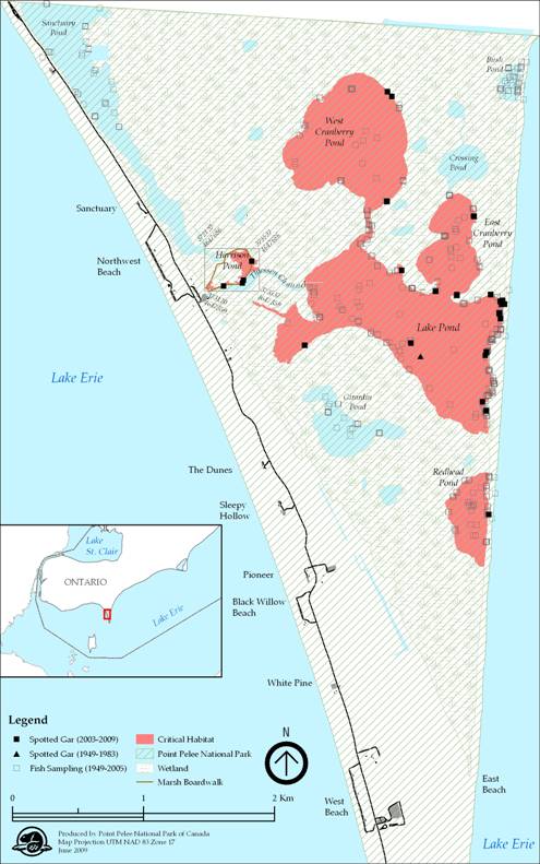
Long Point Bay/Big Creek NWA
The area within which critical habitat is identified includes Big Creek NWA, the area around Inner Long Point Bay, and the mouth of Big Creek (Figure 7). The interior diked cell within Big Creek NWA where Spotted Gar have not been detected has been excluded (the diked cell is not accessible to Spotted Gar). The area within which critical habitat has been identified includes all contiguous waters and wetlands, excluding permanently dry areas, from the causeway west to and including all of Big Creek NWA to the low-head dike, except habitat contained within the interior diked cell within the NWA; Big Creek proper and all contiguous wetlands to the north of Big Creek are included. Within Inner Long Point Bay, the area within which critical habitat is identified extends north to the pier at Port Rowan and south, down to, but not including, the dredged channels of the marina complex (see Figure 7).
Figure 7. Boundaries within which critical habitat for the Spotted Gar is found in Long Point Bay/Big Creek NWA
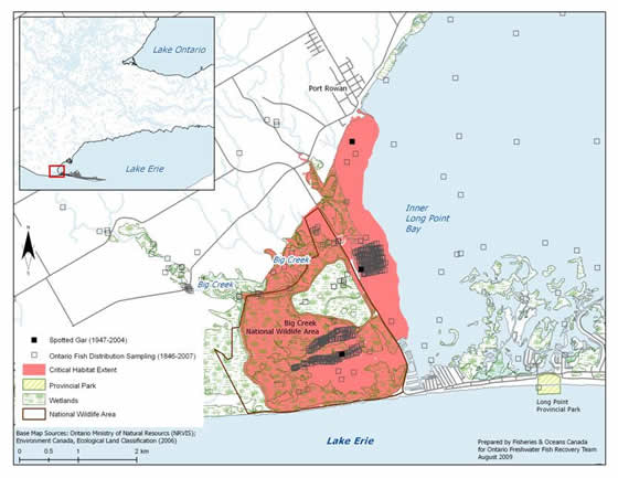
Rondeau Bay
The area within which critical habitat for Spotted Gar is found in Rondeau Bay is currently identified as the waters and wetland areas (including seasonally flooded wetlands) of the entire bay (Figure 8). This includes the mouths of tributaries flowing into the bay, upstream to the point where a defined stream channel is observed. Within Rondeau Provincial Park, aquatic habitats that were isolated from the waters of the bay were excluded as these areas are inaccessible to Spotted Gar. In particular, the areas identified as wetlands to the east of Marsh Trail actually contain large sections of upland terrestrial habitats that isolate interior wetland pockets (i.e., sloughs) (S. Dobbyn, OMNR, pers. comm. 2009). Approximately half of the area within which critical habitat is identified, lies within Rondeau Provincial Park.
Figure 8. Boundaries within which critical habitat for the Spotted Gar is found in Rondeau Bay
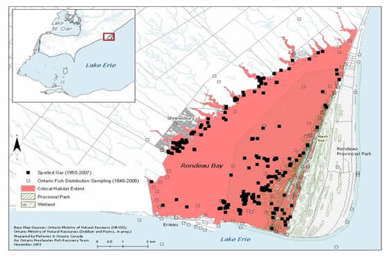
The identification of critical habitat within Point Pelee National Park, Long Point Bay/Big Creek NWA, and Rondeau Bay ensures that currently occupied habitat supporting Spotted Gar is protected, until such time as critical habitat for the species is further refined according to the schedule of studies laid out in Section 2.7.5. The recovery team recommends to the Minister of Fisheries and Oceans that these areas are necessary to achieve the identified survival and recovery objectives. The schedule of studies outlines activities necessary to refine the current critical habitat descriptions at confirmed extant locations, but will also apply to new locations with established populations should they be confirmed (e.g., East Lake, Hamilton Harbour). Critical habitat descriptions will be refined as additional information becomes available to support the population and distribution objectives.
Population Viability
Comparisons were made with the extent of critical habitat identified for each population relative to the estimated MAPV (Table 10). It should be noted that for some populations, it is likely that only a portion of the habitat within that identified as the critical habitat would meet the functional habitat requirements of the species' various life-stages. In addition, since these populations occur in areas of degraded habitat (MAPV assumes habitat quality is optimal), areas larger than the MAPV may be required to support an MVP. Future studies may help quantify the amount and quality of available habitat within critical habitats for all populations; such information, along with the verification of the MAPV model, will allow greater certainty for the determination of population viability. As such, the results in Table 10 are preliminary and should be interpreted with caution.
| Population | Area of critical habitat identified (km²) | MAPV (km²) | MAPV achieved (Yes/No) |
|---|---|---|---|
| Point Pelee National Park | 2.2 | 35 | No |
| Long Point Bay/Big Creek NWA | 7.7 | 35 | No |
| Rondeau Bay (including Rondeau Provincial Park) | 37 | 35 | Yes |
* The MAPV estimation is based on modeling approaches described above. For greater detail refer to Young and Koops (2010).
Schedule of studies to identify/refine critical habitat
This recovery strategy includes an identification of critical habitat to the extent possible, based on the best available information. Further studies are required to refine critical habitat identified for the Spotted Gar to support the population and distribution objectives for the species. The activities listed in Table 11 are not exhaustive and it is likely that the process of investigating these actions may identify additional knowledge gaps that will need to be addressed.
| Description of activity | Rationale | Approximate timeline |
|---|---|---|
| Conduct studies to determine the habitat requirements for each life-stage of the Spotted Gar (in particular the habitat requirements of yolk-sac stage, YOY and juveniles). | There is no published information on the habitat requirements for juvenile Spotted Gar. Determining the habitat requirements for each life-stage will ensure that all necessary features and attributes of critical habitat for this species will be identified. | 2013-2015 |
| Survey and map habitat quality and quantity within historical and current sites, as well as sites adjacent to currently occupied habitat. | Strengthen confidence in data used to determine if sites meet the criteria for critical habitat; assist in refining the spatial boundaries of critical habitat. | 2013-2015 |
| Conduct additional species surveys to fill in distribution gaps, and to aid in determining population connectivity. | Additional populations and corresponding critical habitat may be required to meet the population and distribution objectives. | 2013-2015 |
| Create a population-habitat supply model for each life-stage. | Will aid in developing recovery targets and determining the quantity of critical habitat required by each life-stage to meet these targets. | 2015-2017 |
| Based on information gathered, review population and distribution goals. Determine amount and configuration of critical habitat required to achieve goal if adequate information exists. Validate model. | Revision of recovery targets may be required to ensure that they are achievable and defensible; Will allow further refinement of critical habitat description (spatial and biophysical attributes). | 2015-2017 |
Activities identified in this schedule of studies will be carried out through collaboration between DFO, PCA, EC-CWS, the EERT, First Nations and other relevant groups and land managers. Note that many of the individual recovery approaches will address some of the information requirements listed above.
Examples of activities likely to result in destruction of critical habitat
Activities that increase siltation/turbidity levels and/or result in the removal of excessive amounts of native aquatic vegetation can negatively impact Spotted Gar habitat. However, in areas where nutrient loading has resulted in the extreme overgrowth of aquatic vegetation, small-scale vegetation removal may benefit the species. In these situations, dependent on site-specific reviews, small-scale vegetation removal projects using approved chemical and/or physical means may be allowed. Appendix 3 provides additional guidance on vegetation removal.
Without appropriate mitigation, direct destruction of habitat may result from work or activities such as those identified in Table 12.
The activities described in this table are neither exhaustive nor exclusive and have been guided by the General Threats described in Section 1.5 of the recovery strategy for the species. The absence of a specific human activity does not preclude, or fetter the department’s ability to regulate it pursuant to SARA. Furthermore, the inclusion of an activity does not result in its automatic prohibition since it is destruction of critical habitat that is prohibited. Since habitat use is often temporal in nature, every activity is assessed on a case-by-case basis and site-specific mitigation is applied where it is reliable and available. In every case, where information is available, thresholds and limits are associated with attributes to better inform management and regulatory decision-making. However, in many cases the knowledge of a species and its critical habitat may be lacking and in particular, information associated with a species or habitat tolerance threshold to disturbances from anthropogenic activities, is not available and must be acquired.
The critical habitat for Spotted Gar will be legally protected through the application of subsection 58(1) of SARA, which prohibits the destruction of any part of the critical habitat of aquatic species listed as Endangered or Threatened, and of any part of the critical habitat of aquatic species listed as Extirpated if a recovery strategy has recommended their reintroduction into the wild in Canada.
| Activity | Effect - pathway | Function affected | Feature affected | Attribute affected |
|---|---|---|---|---|
| Habitat modifications: Dredging Grading Excavation Structure removal (e.g., log salvage) | Changes in bathymetry and shoreline morphology caused by dredging and near-shore grading and excavation can remove (or cover) preferred substrates, change water depths, change flow patterns potentially affecting turbidity, nutrient levels, water temperatures, and migration. Removal of in-water structure can remove cover and affect feeding success and spawning. |
| Coastal wetlands and connected quiet backwater areas along the north shore of Lake Erie: including interconnected flooded riparian areas and contributing channels. |
|
| Habitat modifications: Placement of material or structures in water (e.g., groynes, piers, infilling, partial infills, jetties); Shoreline hardening | Placing material or structures in water reduces habitat availability (e.g., the footprint of the infill or structure is lost). Placement of fill can cover preferred substrates, aquatic vegetation and underwater structure. Changing shoreline morphology can result in altered flow patterns, change sediment depositional areas, cause erosion, and alter turbidity levels. These changes can affect aquatic plant growth and cause changes to nutrient levels, and may affect fish movements. Hardening of shorelines can reduce organic inputs into the water and alter water temperatures potentially affecting the availability of prey for this species. | All (same as above) | All (same as above) | All (same as above) |
| Habitat modifications: Water extraction or draining of wetlands (e.g., ditching, channelization and diking); Change in timing, duration and frequency of flow | Water extraction can reduce the availability of wetland habitats. Draining wetlands can reduce the availability of habitat used by various life-stages of this species. Water depths can be reduced, affecting aquatic plant growth, underwater structure that would provide cover and impact water temperatures. Organic inputs from drained wetlands could be reduced, potentially affecting the availability of prey. Works associated with the draining of wetlands (e.g., ditching, channelization and diking) can cause increased turbidity levels and alter flows. Altered flow patterns can affect sediment deposition (e.g., changing preferred substrates), availability of flooded vegetation during spawn, turbidity and nutrient levels | All (same as above) | All (same as above) | All (same as above) |
| Habitat modifications: Unfettered livestock access to waterbodies | When livestock have unfettered access to waterbodies damage or loss of riparian and aquatic vegetation can occur. Resulting damage to shorelines, banks and watercourse bottoms can cause increased erosion and sedimentation, affecting turbidity and water temperatures. Such access can also increase organic nutrient inputs into the water causing nutrient loading and potentially affecting aquatic plant growth, promoting algal blooms and decreasing prey abundance. |
| All (same as above) | All (same as above) |
| Aquatic and riparian vegetation removal: Vegetation clearing (mechanical and chemical removal) | Removal of aquatic or riparian vegetation required by the species to spawn and for cover can negatively affect recruitment and predation success. Plant die-off following chemical treatments and the removal of plant material can also negatively impact water quality, affect turbidity and water temperatures. | All (same as above) | All (same as above) | All (same as above) |
| Turbidity and sediment loading: Work in or around water with improper sediment and erosion control (e.g., use of industrial equipment, cleaning or maintenance of bridges or other structures, etc.) | Improper sediment and erosion control or inadequate mitigation can cause increased turbidity levels, potentially reducing feeding success or prey availability, impacting the growth of aquatic vegetation and possibly excluding fish from habitat due to physiological impacts of sediment in the water (e.g., gill irritation). |
| All (same as above) | All (same as above) |
| Nutrient loadings: Over-application of fertilizer and improper nutrient management (e.g., organic debris management, wastewater management, animal waste, septic systems and municipal sewage) | Poor land management practices and improper nutrient management can result in overland runoff and nutrient loading of nearby waterbodies Elevated nutrient levels can cause increased aquatic plant growth changing water temperatures. The availability of prey species can also be affected if prey are sensitive to organic pollution. | All (same as above) | All (same as above) | All (same as above) |
| Deliberate introduction of exotic species | Feeding by Common Carp can increase turbidity and uproot aquatic vegetation that Spotted Gar may use for cover. The presence of Florida Gar may exclude Spotted Gar from preferred habitat and cause increased competition for prey. |
| All (same as above) | All (same as above) |
| Barriers to movement: Dams, weirs and culverts (e.g., fish passage issues) | The installation of structures that restrict fish passage can limit the movement of individuals, fragmenting populations. Flow alterations sometimes associated with these structures can impact habitat availability further (see: Habitat modifications: change in timing, duration and frequency of flow). Barriers can alter water levels upstream and downstream affecting habitat availability. |
| All (same as above) | All (same as above) |
Certain habitat management activities are recognized as being beneficial to the long-term survival and/or recovery of the species and may be allowed when required. Such activities may include the removal or control of exotic aquatic/semi-aquatic vegetation; water level management (including dike maintenance); and habitat restoration activities (e.g., fire management). For example, in NWAs, water levels may be managed and some aquatic vegetation may be removed to maintain hemi-marsh conditions (i.e., 50/50 emergent/open water habitat). Other restoration activities that improve the quality and/or quantity of available wetland habitat for the Spotted Gar may also be considered.
Existing and recommended approaches to habitat protection
Habitat of the Spotted Gar receives general protection from works or undertakings under the habitat protection provisions of the federal Fisheries Act. The Canadian Environmental Assessment Act (CEAA) also considers the impacts of projects on all listed wildlife species and their critical habitat where it has been identified. During the CEAA review of a project, all adverse effects of the project on a listed species and its critical habitat must be identified. If the project is carried out, measures must be taken that are consistent with applicable recovery strategies or action plans to avoid or lessen those effects (mitigation measures) and to monitor those effects.
Critical habitat for the Spotted Gar located in both Point Pelee National Park and Big Creek NWA will be protected by the prohibition against destruction of critical habitat, pursuant to subsection 58(2) of the SARA, 90 days after the description of critical habitat, as identified in the recovery strategy, is published in the Canada Gazette. This prohibition provides additional protection to that already afforded and available under the Canada National Parks Act and Canada Wildlife Act, respectively, as well as the regulations associated with those statutes. Individuals of listed species at risk populations located on lands and in waters under the administration of the federal government also receive protection under SARA once the species is listed on Schedule 1 of SARA.
Provincially, protection is also afforded under the provincial Planning Act. Planning authorities are required to be “consistent with” the provincial Policy Statement under Section 3 of Ontario’s Planning Act, which prohibits development and site alteration in the habitat of regulated Endangered and Threatened species. Stream-side development in Ontario is managed through floodplain regulations enforced by local conservation authorities. Under the Public Lands Act, a permit may be required for work in the water and along the shore. The Spotted Gar is listed as a Threatened species under Ontario’s Endangered Species Act, 2007. Under the Act, the species itself is currently protected, and the habitat of the Spotted Gar will be protected under the general habitat protection provisions of the Act as of June 20, 2013, unless a species-specific habitat regulation is developed by the provincial government at an earlier date.
Existing populations of Spotted Gar in Lake Erie are found in Point Pelee National Park, Rondeau Provincial Park (which represents the eastern portion of the bay only), Long Point Bay (including the NWA), and Big Creek NWA, which affords the species some protection. Currently occupied habitat receives additional protection afforded to NWAs through the Canada Wildlife Act, and provincial parks through the Provincial Parks and Conservation Reserves Act.
Currently, recommended high priority areas for stewardship include Rondeau Bay watersheds where land use impacts appear to be compromising habitat conditions within the bay.
Effects on other species
It is conceivable that increased populations of Spotted Gar could result in increased predation of other co-occurring fishes at risk (e.g., Grass Pickerel [Esox americanus vermiculatus], Lake Chubsucker, Pugnose Shiner [Notropis anogenus] and Warmouth [Lepomis gulosus]). However, the proposed recovery activities will benefit the environment in general and are expected to have a net positive effect on other sympatric native species. While there is potential for conflicts with other species at risk (aquatic and aquatic-dependent) during recovery implementation, this possibility will be minimized through strong coordination among the various recovery teams and groups/government agencies that may be working on species at risk and habitat management within the coastal wetland areas of Lake Erie. In addition, most stewardship and habitat improvement activities will be implemented through the Essex-Erie recovery initiative, which provides for a high awareness of other recovery programs. DFO, Environment Canada, and PCA recognize that an ecosystem approach to habitat management is necessary to ensure habitat management decisions address the needs of all species at risk within overlapping critical habitat areas (e.g., Least Bittern [Ixobrychus exilis], Spotted Gar, Lake Chubsucker).
Recommended approach for recovery implementation
This single species document is one component of recovery implementation for co-occurring species at risk found in the same location. The Ontario Freshwater Fish Recovery Team recommends making effective use of resources and reducing costs by coordinating efforts with relevant groups, the EERT and its associated RIGs in the areas where this species exists. The three coastal wetlands of Lake Erie inhabited by Spotted Gar have been identified by the EERT as primary core areas for directing recovery efforts to benefit this species. The EERT and its RIGs include representation from park agencies responsible for the management of these wetland habitats. This overlap of individuals affiliated with these plans will help ensure that recovery actions for the Spotted Gar mesh with existing park management plans. Although Spotted Gar is included in the Sydenham River recovery strategy (Dextrase et al. 2003), the original records for this watershed have since been deemed questionable (COSEWIC 2005).
Statement on action plans
Action plans are documents that describe the activities designed to achieve the recovery goals and objectives identified in recovery strategies. Under SARA, an action plan provides the detailed recovery planning that supports the strategic direction set out in the recovery strategy for the species. The plan outlines what needs to be done to achieve the recovery goals and objectives identified in the recovery strategy, including the measures to be taken to address the threats and monitor the recovery of the species, as well as the measures to protect critical habitat. Action plans offer an opportunity to involve many interests in working together to find creative solutions to recovery challenges.
One or more action plans relating to this recovery strategy will be produced within five years of the final strategy being posted to the SARA registry. These may include multi-species or ecosystem based action plans.
References
Alfaro, R.M., C.A. González, and A.M. Ferrara. 2008. Gar biology and culture: status and prospects. Aquaculture Research 39: 748-763.
Battin, J.G. and J.G. Nelson. 1978. Man’s impact on Point Pelee National Park. National and Provincial Parks Association of Canada. 175 pp.
Bouvier, L.D. and N.E. Mandrak. 2010. Information in support of a Recovery Potential Assessment of Spotted Gar (Lepisosteus oculatus) in Canada. DFO Canadian Science Advisory Secretariat Research Document 2010/079. vi + 22 pp.
Burleson, M., B. Shipman, and N. Smatresk. 1998. Ventilation and acid-base recovery following exhausting activity in an air-breathing fish. Journal of Experimental Biology 201(9): 1359-1368.
COSEWIC (Committee on the Status of Endangered Wildlife in Canada). 2005. COSEWIC assessment and update status report on the Spotted Gar, Lepisosteus oculatus, in Canada. Committee on the Status of Endangered Wildlife in Canada: Ottawa, Ontario. vi + 17 pp.
Coen L.D., K.L. Heck, Jr., and L.G. Abele. 1981. Experiments on competition and predation among shrimps of seagrass meadows. Ecology 62: 1484—1493.
Coker, G.A., C.B. Portt, and C.K. Minns. 2001. Morphological and ecological characteristics of Canadian freshwater fishes. Canadian Manusript Report of Fisheries and Aquatic Sciences 2554: iv + 89 pp.
Cudmore-Vokey, B. and C.K. Minns. 2002. Reproductive ecology and vegetation association databases of Lake Ontario fishes. Canadian Manuscript Report of Fisheries and Aquatic Sciences 2607: ix + 42 pp.
Dextrase, A., S.K. Staton, and J.L. Metcalfe-Smith. 2003. National recovery strategy for species at risk in the Sydenham River: an ecosystem approach. National Recovery Plan No. 25. Recovery of Nationally Endangered Wildlife (RENEW): Ottawa, Ontario. 73 pp.
Dobbyn, S. and L. Pasma. (In prep). A life science inventory and evaluation of Rondeau Provincial Park. Draft March 2005. Ontario Parks, Ontario Ministry of Natural Resources
Doka, S., C. Bakelaar, and L. Bouvier. 2006. Chapter 6. Coastal wetland fish community assessment of climate change in the lower Great Lakes. In L. Mortsch, J. Ingram, A. Hebb and S. Doka (eds.), Great Lakes Wetland Communities: Vulnerability to Climate Change and Response to Adaptation Strategies, Environment Canada and the Department of Fisheries and Oceans, Toronto, Ontario. pp. 101-127.
EERT (Essex-Erie Recovery Team). 2008. Recovery strategy for the fishes at risk of the Essex-Erie region: an ecosystem approach. July 2008 Draft. 110 pp.
Ferrara, A.M. 2001. Life history strategy of Lepisosteidae: implications for the management and conservation of the alligator gar. PhD. Dissertation, Auburn University, Alabama. 145 pp.
Fuller, P., A. Benson, and E. Maynard. 2009. Apollonia (Neogobius) melanostomus. USGS Nonindigenous Aquatic Species Database, Gainesville, FL. Revision Date: 10/25/2007. (Accessed: Feb. 2009.)
Gilbert, J., G. Dunn, and B. Locke. 2007. Rondeau Bay ecological assessment report. Report prepared for the Ontario Ministry of Natural Resources. May 2007.
Glass, W.R., L.D. Corkum, N.E. Mandrak. 2011. Pectoral fin ray aging: an evaluation of a non-lethal method for aging gars and its application to a population of the threatened Spotted Gar. Environmental Biology of Fishes 90: 235-242.
Goodyear, C.S., T.A. Edsall, D.M. Ormsby Dempsey, G.D. Moss, and P.E. Polanski. 1982. Atlas of the spawning and nursery areas of Great Lakes fishes. Volume 13: Reproductive characteristics of Great Lakes fishes. U.S. Fish and Wildlife Service, FWS/OBS-8252. 144 pp.
Lane, J.A., C.B. Portt, and C.K. Minns. 1996. Adult habitat characteristics of Great Lakes fishes. Canadian Manuscript Report of Fisheries and Aquatic Sciences 2358: v + 43 pp.
Lee, D.S., C.R. Gilbert, C.H. Hocutt, R.E. Jenkins, D.E. McAllister, and J.R. Stauffer Jr. 1980. Atlas of North American freshwater fishes. N.C. State Museum of Natural History, Raleigh, North Carolina. 854 pp.
Lee, H.T., W.D. Bakowsky, J.L. Riley, J. Bowles, M. Puddister, P. Uhlig, and S. McMurray. 1998. Ecological Land Classification for southern Ontario: first approximation and its application. Ontario Ministry of Natural Resources, Southcentral Science Section, Science Development and Transfer Branch. SCSS Field Guide FG-02.
Lee, H.T., D. Leadbeater, P. Uhlig, and K. Ursic. 2001. Ecological Land Classification for southern Ontario: training manual. Ontario Ministry of Natural Resources, SCSIS Training Manual TM-01.
Lemmen, D.S. and F.J. Warren. 2004. Climate change impacts and adaptation: a Canadian perspective. Natural Resources Canada: Ottawa, Ontario.
Mandrak, N.E. 1989. Potential invasion of the Great Lakes by fish species associated with climatic warming. Journal of Great Lakes Research 15: 306-316.
Mandrak, N.E., J. Barnucz, and D. Marson. 2006a. Fish community sampling in National Wildlife Areas in southwestern Ontario, 2002-2005 (Draft). Canadian Manuscript Report of Fisheries and Aquatic Sciences. iii + 36 pp.
Mandrak, N.E., J. Barnucz, G.J. Velema, and D. Marson. 2006b. Survey of the status of Black Redhorse (Moxostoma duquesnei), and Spotted Gar (Lepisosteus oculatus), in Canada, 2002. Canadian Manuscript Report of Fisheries and Aquatic Sciences 2776: v + 39 pp.
NatureServe. 2009. NatureServe Explorer: an online encyclopedia of life [web application]. Version 7.1. NatureServe, Arlington, Virginia. (Accessed: Feb. 2009).
Ontario Federation of Anglers & Hunters. 2011. InvadingSpecies.com - Zebra Mussel (Dreissena polymorpha) (Accessed: October 2011).
Ontario Ministry of Natural Resources. 2009. Species at risk in Ontario (SARO) list. (Accessed: February 2009.)
Ostrand, K.G., M.L. Thies, D.D. Hall, and M. Carpenter. 1996. Gar ichthyotoxin: its effect on natural predators and the toxin’s evolutionary function. Southwest Naturalist 41: 375-377.
Ostrand, K.G., B.J. Braeutigam, and D.H. Wahl. 2004. Consequences of vegetation density and prey species on Spotted Gar foraging.Transactions of the American Fisheries Society 133: 794—800.
Page, L.M. and B.M. Burr. 1991. A field guide to freshwater fishes of North America north of Mexico. Houghton Mifflin Company: Boston, Massachusetts.
Parker, B. and P. McKee. 1984. Status of the Spotted Gar, Lepisosteus oculatus, in Canada. Canadian Field-Naturalist 98(1): 80-86.
Parker, R.S., C.T. Hackney, and M.F. Vidrine. 1984. Ecology and reproductive strategy of a South Louisiana freshwater mussel, Glebula rotundata (Lamarck) (Unionidae: Lampsilini). Freshwater Invertebrate Biology 3(2): 53-58.
Razavi, R. 2006. Assessing historical and present day fish habitat in the marshes of Point Pelee National Park. Senior Honours Thesis. Department of Biology, McMaster University, Hamilton, Ontario. 65 pp.
Reid, S.M. and N.E. Mandrak. 2008. Historical changes in the distribution of threatened Channel Darter (Percina copelandi) in Lake Erie with general observations on the beach fish assemblage. Journal of Great Lakes Research 34: 324-333.
Ricciardi, A. 2006. Patterns of invasion in the Laurentian Great Lakes in relation to changes in vector activity. Diversity and Distributions 12: 425-433.
Scott, W.B. 1967. Freshwater fishes of eastern Canada. 2nd edition. University of Toronto Press, Toronto, Ontario. 137 pp.
Scott, W.B. and E.J. Crossman. 1998. Freshwater fishes of Canada. Bulletin 184, Fisheries Research Board of Canada. Reprinted by Galt House Publications, Burlington, ON. xvii + 966 pp.
Simon, T.P. and R. Wallus. 1989. Contributions to the early life histories of gar (Actinopterygii: Lepisosteidae) in the Ohio and Tennessee River Basins with emphasis on larval development. Transactions of the Kentucky Academy of Science 50: 59-74.
Snedden, G.A., W.E. Kelso, and D.A. Rutherford. 1999. Diel and seasonal patterns of Spotted Gar movement and habitat use in the lower Atchafalaya River Basin, Louisiana. Transactions of the American Fisheries Society 128: 144-154.
Staton, S.K., K.L. Vlasman, and A.L. Edwards. 2010. Recovery strategy for the Lake Chubsucker (Erimyzon sucetta) in Canada. Species at Risk Act Recovery Strategy Series, Fisheries and Oceans Canada, Ottawa. vi + 49 pp.
Surette, H.J. 2006. Processes influencing temporal variation in fish species composition in Point Pelee National Park. M.Sc. Thesis. University of Guelph, Guelph, ON. 105 pp.
Tyler, J.D. and M.N. Granger.1984. Notes on food habits, size, and spawning behavior of Spotted Gar in Lake Lawtonka, Oklahoma. Proceedings of the Oklahoma Academy of Science 64: 8-10.
Vélez-Espino, L.A., R.G. Randall, and M.A. Koops. 2008. Quantifying habitat requirements of four freshwater species at risk in Canada: Northern Madtom, Spotted Gar, Lake Chubsucker, and Pugnose Shiner. Canadian Science Advisory Secretariat Research Document 2008/nnn. iv + 20 pp.
Young, J.A.M and M.A. Koops. 2010. Recovery potential modelling of Spotted Gar (Lepisosteus oculatus) in Canada. DFO Canadian Science Advisory Secretariat Research Document 2010/078. iv + 19 pp.
Recovery team members
The following members of the Ontario Freshwater Fish Recovery Team were involved in the development of the recovery strategy for the Spotted Gar:
Shelly Dunn (Chair): Fisheries and Oceans Canada
Shawn Staton: Fisheries and Oceans Canada
Lynda Corkum, Ph. D.: University of Windsor
Alan Dextrase: Ontario Ministry of Natural Resources
Sandy Dobbyn : Ontario Ministry of Natural Resources (distribution list only)
Amy Boyko: Fisheries and Oceans Canada
Bill Glass: University of Windsor
Brian Locke: Ontario Ministry of Natural Resources
Nicholas Mandrak, Ph. D.: Fisheries and Oceans Canada
Vicki McKay: Parks Canada Agency
Debbie Ming: Fisheries and Oceans Canada
Mike Nelson: Essex Region Conservation Authority
Scott Reid, Ph. D.: Trent University
Emily Slavik: Ontario Ministry of Natural Resources
Daelyn Woolnough, Ph. D.: Trent University
Jeff Robinson: Environment Canada (Canadian Wildlife Service)
Appendix 1. Record of cooperation and consultation
The Spotted Gar recovery strategy was prepared by Fisheries and Oceans Canada (DFO) and Parks Canada Agency (PCA) with input from the Ontario Freshwater Fish Recovery Team. This recovery team was chaired by DFO and includes representatives from PCA, Environment Canada (Canadian Wildlife Service), the Ontario Ministry of Natural Resources (OMNR), Essex Region Conservation Authority (ERCA), Trent University, and the University of Windsor.
The Spotted Gar is also included in the Essex-Erie recovery strategy (EERS). The Essex-Erie Recovery Team (EERT), which prepared that strategy, has representatives from Essex Region Conservation Authority (who co-chaired the team with DFO), Catfish Creek Conservation Authority, Elgin Stewardship Committee, Essex County Stewardship Network, Kettle Creek Conservation Authority, Long Point Region Conservation Authority, OMNR, PCA (Point Pelee National Park), Ontario Ministry of Agriculture and Food and Rural Affairs, Lower Thames Valley Conservation Authority, Stewardship Kent, and University of Windsor.
DFO has attempted to engage all potentially affected Aboriginal communities in southern Ontario during the development of the proposed recovery strategy for the Spotted Gar. Information packages were sent to Chief and Council of Aamjiwnaang First Nation, Chippewas of the Thames First Nation, Mississauga of the New Credit, Moravian of the Thames, Munsee-Delaware Nation, Oneida Nation of the Thames, Six Nations of the Grand River and Walpole Island First Nation. Caldwell First Nation has a particular interest in Point Pelee National Park. Information packages were also sent to Metis Nation of Ontario (MNO) Captain of the Hunt for Region 9 and the MNO senior policy advisor. Members of these communities may have traveled or harvested fish from the waters of Lake Erie where Spotted Gar was historically found. Follow-up telephone calls were made to each community office to ensure that packages were received and to ask if they would like to schedule a meeting to learn more about species at risk in general and proposed recovery strategies.
As a result of these letters and calls, one meeting was held with the Chief and Councillor for environmental issues of the Munsee - Delaware First Nation. Comments received during consultation did not result in notable changes to the recovery strategy.
In addition to the above activities, DFO has established an ongoing dialogue with respect to aquatic species at risk in general with the policy advisor to the Southern First Nations Secretariat and has engaged the London Chiefs Council (an association of the eight area First Nation governments in southwestern Ontario) on several occasions. Meetings have been held with the director of the Walpole Island Heritage Centre and the Resource Protection Program Enforcement Officer from Walpole Island First Nation (WIFN). In March 2011, DFO conducted community consultation sessions with WIFN on several recovery documents, including the present recovery strategy. Feedback and written comments were received for consideration. DFO also discussed SARA issues with a representative of the Six Nations of the Grand who works for the Six Nations EcoCentre and who also represents First Nation interests on the Grand River Fishes at Risk Management Plan, the Thames River Fish Management Plan and the St. Clair River Management Strategy.
Although many Aboriginal and Métis communities already received a letter from DFO (in April 2007) regarding a recovery strategy for the Spotted Gar, given the passage of time and the addition of critical habitat to the recovery strategy, a new letter was sent to First Nations to invite their comments on the updated strategy. This letter was sent in advance of the proposed recovery strategy being posted on the SARA Registry.
DFO prepared a list of non-government organizations and municipalities that may be impacted by the proposed recovery strategy. Information packages were prepared to inform these groups that the proposed recovery strategy was about to be approved and invited each group to comment on the strategy. As well, an announcement was prepared and placed in newspapers with circulation in the area where this fish is known to exist and was historically found to inform landowners and the general public about the strategy and to request their comments. These packages were sent and the announcements published at the time the proposed recovery strategy was posted on the SARA registry.
Appendix 2: Background Data Summary and Rationale For Areas Identified As Critical Habitat
Point Pelee National Park
The ponds within Point Pelee National Park were rigorously sampled by Surette (2006) over a two year period, providing an extensive dataset for this population. Using these data, and the records of Razavi (2006), A.-M. Cappelli (unpublished data, 2009) and B. Glass (unpublished data, 2009), critical habitat for the Spotted Gar has been identified using an area of occupancy approach. Areas historically and presently known as Redhead Pond, Lake Pond, East Cranberry Pond, and West Cranberry Pond, as identified on the National Topographic System (NTS) map 40 G/15, and Harrison Pond are recommended critical habitat. The highly managed watercraft passage between Harrison and Lake Ponds known as Thiessen Channel (Figure 6) is excluded from this critical habitat description.
Records of Spotted Gar have recently been documented through sampling efforts in these ponds within Point Pelee National Park. Nineteen records (individuals ranging in length from 500-629 mm TL) were documented during 605 sampling events across all Park ponds in 2002 and 2003 (Surette 2006). Nine records were reported in 2005 (Razavi 2006) during a study of Sanctuary and Lake ponds to determine the quality of the Point Pelee National Park marshes using ecological integrity indicators. Observations of Spotted Gar within Harrison Pond, with photographic documentation, were made in May 2009 (A.-M. Cappelli, unpublished data) and a total of 93 Spotted Gar were captured in West Cranberry and Lake ponds in May 2009 for a genetics study (B. Glass, UW, unpublished data, 2009).
While visual observations of Spotted Gar, with photographic documentation, were made in 2009 in Harrison Pond, and in 2007 in Thiessen Channel (S. Staton, pers. obs.), existing anthropogenic features in these areas, including the Marsh Boardwalk (stationary and floating sections) and the area it occupies as well as Thiessen Channel, are excluded from this critical habitat description. The area occupied by the floating section of the boardwalk is delineated by the outer limits of the paired, metal containment pilings that the floating section shifts between. Thiessen Channel is excluded because it has been highly managed (modified and maintained) since at least 1922 to allow for watercraft passage from the western boundary of the marsh into Lake Pond and the other connecting ponds (Battin and Nelson 1978).
Rondeau Bay
Up until 2004, only 27 Spotted Gar had been captured at Rondeau Bay since it was first recorded from this location in 1955; however, in 2007, 210 specimens were caught at Rondeau, including 39 individuals from one net (B. Glass, UW, unpublished data). Spotted Gar specimens captured in Rondeau Bay since 2002 ranged in length from 433-761 mm TL. These capture data, as well as tracking data, indicate that Spotted Gar are distributed throughout Rondeau Bay (B. Glass, unpublished data).
Using these data, the area within which critical habitat for Spotted Gar is currently found, based on an area of occupancy approach, is identified as the waters and wetland areas (including seasonally flooded wetlands) of the entire bay (Figure 8). This includes the mouths of tributaries flowing into the bay, upstream to the point where a defined stream channel is observed.
Within Rondeau Provincial Park, the area within which critical habitat for Spotted Gar is found was further refined using available ELC data for the park. ELC assesses the distribution and groupings of plant species and attempts to understand them according to ecosystem patterns and processes. It also helps to establish patterns among vegetation, soils, geology, landform and climate, at different scales. Using the factors relating to geology, soils, physiography and vegetation, ELC can be used to map vegetation communities at varying organizational scales (Lee et al. 1998, Lee et al. 2001). Spotted Gar capture locations within the park were compared with the park ELC data (Dobbyn and Pasma, in prep.) to determine the wetland vegetation types used by the species. All areas containing these ELC types were initially included as critical habitat; however, aquatic habitats that were isolated from the waters of the bay were excluded as these areas are inaccessible to Spotted Gar. In particular, the areas identified as wetlands to the east of Marsh Trail actually contain large sections of upland terrestrial habitats that isolate interior wetland pockets (i.e., sloughs) (S. Dobbyn, OMNR, pers. comm. 2009). Approximately half of the area within which critical habitat is identified lies within Rondeau Provincial Park.
Long Point Bay/Big Creek NWA
Limited data are available for the Spotted Gar population in Long Point Bay; there are currently 11 records for Spotted Gar in Inner Long Point Bay, the most recent of which is from 2010 (B. Glass, UW, unpublished data). The species was captured for the first time in Big Creek NWA (connected to Long Point Bay) in 2004, when two individuals (502 and 566 mm TL) were captured from one location (L. Bouvier, DFO, pers. comm. 2008). Additionally, Spotted Gar has been reported from the Long Point Unit (located at the tip of the point) of Long Point NWA; however, critical habitat has not been identified at this time as the record is 25 years old and was represented by a single specimen.
Using available data, the area within which critical habitat is currently found, based on an area of occupancy approach and refined using ELC, is identified as the wetland (including marsh, meadow marsh, shallow marsh, common reed, floating-leaved and mixed shallow aquatic, and thicket swamp ELC community classes) and aquatic (less than 2 m depths including open aquatic, submerged shallow aquatic, and open-submerged-floating-leaved, mixed ELC community classes) areas within Big Creek NWA, the area around Inner Long Point Bay and the mouth of Big Creek (Figure 7). Excluded from this description is the interior diked cell within Big Creek NWA where Spotted Gar have not been detected (the diked cell is not accessible to Spotted Gar).
The area within which critical habitat is found includes all contiguous waters and wetlands, excluding permanently dry areas, from the causeway west to and including all of Big Creek NWA to the low-head dike, except habitat contained within the interior diked cell within the NWA, and including Big Creek proper and all contiguous wetlands to the north of Big Creek. Within Inner Long Point Bay, the area within which critical habitat is found extends north to the pier at Port Rowan and south, down to, but not including, the dredged channels of the marina complex (see Figure 7).
Appendix 3. Aquatic Vegetation Removal - Guidelines
Nutrient loading leading to excessive overgrowth of aquatic vegetation can reduce the quality of Spotted Gar habitat. In these situations, it is possible that limited vegetation removal could benefit the long term survival and recovery of Spotted Gar. Subject to site-specific reviews, small-scale vegetation removal projects using approved means may be allowed.
Site-specific reviews may be required for all proposed vegetation removal projects in Spotted Gar habitat and SARA permits are required. To minimize the potential impacts, the Rondeau Bay Aquatic Vegetation Issues Working Group in consultation with the Spotted Gar Recovery Team has recommended the following interim guidelines (2010) for limited vegetation removals. Note that future research may inform changes to these interim guidelines:
- removals within the nearshore zone (up to 1 m in water depth) will be restricted to a perpendicular channel not more than 1 m in width (to minimize potential harm to spawning and nursery habitat);
- private swimming areas will be limited to a maximum area of 6 m x 10 m, in water depths greater than 1 m;
- private boating channels will not exceed 4 m in width in water depths greater than 1 m;
- ‘main’ or ‘collector’ boating channels will not exceed 6 m in width.
*IMPORTANT NOTICE AND DISCLAIMER: DFO does not assume any responsibility for the quality of information, products or services listed in the Web sites provided above. Users should also be aware that information from external sources is available only in the language in which it was provided.
The recovery strategy for Spotted Gar is available in PDF format upon request. Please email PDF requests to recovery.planning@ontario.ca.