Survey protocol for Blanding’s Turtle in Ontario
This survey protocol provides a standardized, science-based approach for conducting field surveys for Blanding’s Turtle in Ontario.
Recommended citation
Ontario Ministry of Natural Resources and Forestry (OMNRF). 2015. Survey Protocol for Blanding’s Turtle (Emydoidea blandingii) in Ontario. Species Conservation Policy Branch. Peterborough, Ontario. ii + 16 pp.
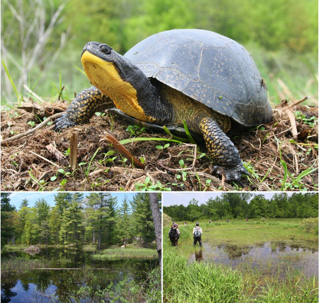
Cover illustration: Photographs by Joe Crowley, Herpetology Species at Risk Specialist, Ontario Ministry of Natural Resources and Forestry.
Cette publication hautement spécialisée, protocole de suivi de la tortue mouchetée (Emydoidea blandingii) en Ontario n’est disponible qu’en anglais en vertu du Règlement 671/92 qui en exempte l’application de la Loi sur les services en français. Pour obtenir de l’aide en français, veuillez communiquer avec le ministère des Richesses naturelles au
Le présent document vise à établir un protocole normalisé et efficace pour la réalisation d’études sur le terrain sur la tortue mouchetée en Ontario. Ce protocole décrit les aspects de la biologie de l’espèce qui sont associés à sa détectabilité et à son identification, son aire de répartition, les méthodes d’étude qui conviennent, les qualifications de l’expert et les normes de communication des données en Ontario. Il décrit aussi les conditions qui sont nécessaires pour déduire avec suffisamment d’assurance que l’espèce en question est absente dans une région donnée. Le protocole vise à éclairer le travail réalisé sur la tortue mouchetée conformément aux exigences ou aux conditions de la Loi ontarienne sur les espèces en voie de disparition, mais il peut aussi être appliqué dans d’autres situations où des études sur la tortue mouchetée doivent être entreprises en Ontario.
© Queens Printer for Ontario, 2015
ISBN 978-1-4606-4773-8 (PDF)
1. Introduction
Effective protection and recovery of species at risk and their habitat requires comprehensive and up-to-date knowledge of species’ occurrence and distribution. However, there have been few large-scale surveys and inventories for most of Ontario’s species at risk, and recent, detailed occurrence data are not available for many of these species throughout the province. In the absence of existing detailed occurrence data, field surveys are necessary to determine if a species is present at a particular site. However, many species at risk are inherently rare, occur at low densities and are very cryptic, making detection of these species difficult. Furthermore, the detection probability of some species varies considerably with time of year, weather and search method. This Species at Risk Survey Protocol was developed in response to the need for reliable, science-based survey methods for species at risk in Ontario.
In addition to providing survey methodology, the protocol also identifies the level of search effort that is necessary to determine, with reasonable confidence, that Blanding’s Turtles are absent from a site. This level of search effort is recommended when survey data are used to inform assessments of species’ absence. This protocol does not provide methodology to determine population abundance or monitor changes over time. For information about determining species abundance, population monitoring and other field methodology for reptiles see McDiarmid et al. 2012.
This survey protocol is based on the best available scientific information at the time of publication, including information from several expert Ontario herpetologists. The survey protocol may be subject to change should new information become available.
This survey protocol provides a recommended approach to assess presence / absence at a site. However, determining if there is habitat present under the Endangered Species Act, 2007 (ESA) (general or regulated habitat) at a site is a complex process that is not limited to presence / absence surveys. For example, even at sites where survey results are negative, general or regulated habitat of a species at risk may still be present based on nearby occurrences of the species (e.g., on an adjacent property) or the manner in which the habitat is defined within a regulation, habitat description or policy.
2. Species information
2.1. Identification
Appearance
- Bright yellow chin and throat
- Smooth, highly domed black carapace (upper shell) with small, irregular tan or yellow flecks, which may be absent or faded on older individuals
- Plastron (lower shell) that is yellow with a large dark blotch in the corner of each scute (scales on the shell), but may be almost entirely black
- Hinged plastron allows front of plastron to close against the front of the carapace; hinge is non-functioning in neonates and young juveniles.
- Carapace can be up to 28 cm in length
- Young juveniles have a grey to brown carapace and lack the bright yellow throat, hinged plastron, and highly domed shell
Similar species
Blanding’s Turtles (especially juveniles) may be confused with Spotted or Wood Turtles. Spotted Turtles generally have large, distinct yellow spots on the carapace rather than flecking, a lower shell profile, and yellow spots on the legs and head. The scutes (enlarged scales) on a Wood Turtle’s shell are typically pyramidal and ridged and the shell of an adult Blanding’s Turtle is generally very smooth and more domed.
2.2. Distribution
Blanding’s Turtles occur throughout southern and central Ontario but appear to be largely absent from the northern portion of south-western Ontario, including most of Grey and Bruce counties, as well as extreme eastern Ontario. As is the case with most reptile species, the known distribution of the species within Ontario (Figure 1) is based largely on opportunistic occurrence data and is not well documented. This is especially true of the northern limit of the species’ range where populations have recently been documented as far north as Timmins and Manitouwadge.
2.3. Seasonal movements and timing of behaviours
Timing of behaviours/movements are based on data from Edge et al 2009; Edge et al 2010; C. Davy unpublished data 2011; C. Edge pers. comm. 2011; NHIC unpublished data 2011; J. Paterson pers. comm. 2011; J. Urquhart pers. comm. 2011 and S. Gillingwater unpublished data 2000-2012. The timing of activities varies with latitude as well as with seasonal weather variation. For example, the active season will begin much earlier in a year with an early spring (e.g. spring of 2012 with temperatures of + 28 °C in mid-March). General timing windows are given but specific calendar dates should be used only as a general guide.
- Active season: Ice-off to late October. The active season typically begins in April, but may begin in late March in southwestern Ontario in some years
- Hibernation: Late October to ice-off (Late March or April)
- Mating: Typically April, September and October but may occur at any time of year, including during hibernation
- Nesting: Late May to early July; lasts about three weeks each year but most activity occurs in one week. Nesting females may travel significant distances; up to six km (Edge et al. 2010) between the resident wetland and nest site.
- Hatching: Mid-August to the end of September
- Adult dispersal/migration: Shortly after the active season begins (usually in April) and in September when turtles are returning to overwintering habitat. Females also make long-distance migrations during the nesting period.

Enlarge a printer-friendly version of distribution map of Blanding’s Turtles in Ontario (PDF)
3. Survey methodology
3.1. Qualifications
Surveyor experience can affect the probability of species detection when surveying for reptiles (BCMELP 1998; Casper et al. 2001), and surveys carried out by inexperienced surveyors are more likely to result in false negatives (Casper et al. 2001; S. Gillingwater pers. comm. 2012; J. Litzgus pers. comm. 2012). Thus, reptile surveys should be carried out by individuals who have a general understanding of reptile biology and ecology and prior experience with the species in question (BCMELP 1998; Casper et al. 2001; DSEWPC 2011; S. Gillingwater pers. comm. 2012; J. Litzgus pers. comm. 2012). If individuals who are experienced with Blanding’s Turtle are not available, it is highly recommended that surveyors have the following qualifications:
- Prior experience conducting wildlife surveys (preferably turtle surveys)
- Knowledge of the biology, ecology and habitat use of Blanding’s Turtles
- The ability to distinguish Blanding’s Turtles from similar species in Ontario (e.g., juvenile Blanding’s Turtle vs. Spotted Turtle).
Surveyors should also have the ability to navigate, record the survey track, and geo-reference observations using a Global Positioning System (GPS) unit.
3.2. Records review
A records review should be carried out prior to a field survey. Existing occurrence records may help to better scope the field survey or, if extensive data is already available for a site, existing records may eliminate the need for a field survey. The absence of occurrence records from an area does not indicate that the species is absent; suitable habitat should be adequately surveyed before concluding that Blanding’s Turtle is unlikely to be present.
The following sources can be consulted for information on Blanding’s Turtle distribution and occurrence records within Ontario:
- OMNRF Natural Heritage Information Centre (NHIC) or by email
- Ontario Reptile and Amphibian Atlas (ORAA)
- Local Conservation Authorities
- Status reports from the Committee on the Status of Endangered Wildlife in Canada (COSEWIC); available through the SARA Public Registry
- Other information sources such as, but not limited to species experts, OMNRF offices, site-related environmental impact or screening reports, published scientific literature and natural history inventories
3.3. Environmental conditions
Environmental conditions are among the most important considerations when planning and carrying out turtle surveys. Turtles are ectotherms and their body temperature is dependent on environmental temperatures. Turtles regulate their body temperature by selecting specific thermal environments that allow them to increase or decrease their body temperature as environmental temperatures change (behavioural thermoregulation). Consequently, turtle habitat use and behaviour is, in part, determined by their thermoregulatory needs. Since metabolic rate and activity level is dependent on temperature, turtles are most active when they are warm and are slow and inactive when they are cold. By influencing turtle behaviour, microhabitat selection and activity levels, environmental conditions have a significant effect on detectability. Following are a few examples of how environmental conditions influence turtle detectability:
- On cool or warm sunny days, turtles will bask to warm up (high detectability).
- On cold overcast days turtles will have little energy and no opportunity to warm up so they will remain hidden and relatively inactive (low detectability).
- On hot sunny afternoons, especially in the summer, turtles will stay underwater or hide in dense vegetation avoid the sun and stay cool (low detectability).
Environmental conditions at the time of the survey should always be documented so that survey results can be accurately interpreted. For example, if a survey is carried out under environmental conditions that would result in low detectability, the species is unlikely to have been detected even if it is present and surveys that fail to find the species under these conditions are not informative.
The likelihood that turtles will bask increases as the temperature differential between the water and the basking sites increases (as long as it remains below the maximum preferred temperature). This thermal difference is not simply the difference between water and air temperature. Temperature in areas that are receiving sun and are sheltered from the wind can be much higher - ten degrees or more - than standard air temperature. Therefore, there can be a high thermal gradient that provides incentive for turtles to bask even when air temperature is not much warmer than water temperature. Similarly, on hot sunny days, basking sites in the sun will be warmer than the air temperature and will often exceed the turtles’ maximum preferred temperature.
3.4. Identification of survey sites
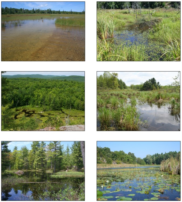
Blanding’s Turtles are primarily aquatic and occupy a variety of shallow eutrophic wetlands such as marshes, swamps, ponds, fens, bogs, slow-flowing streams and shallow bays of lakes or rivers (Gillingwater 2001; Gillingwater and Piraino 2004, 2007; Congdon et al. 2008; Edge et al 2010; Seburn 2010). These sites often have an abundance of vegetation and a soft substrate. Blanding’s Turtles nest in terrestrial habitats with high sun exposure, typically within close proximity to wetlands. The following resources provide detailed information on the habitat use and ecology of this species and should be used as core reference material to accompany this survey protocol.
- OMNRF General Habitat Description for Blanding’s Turtle
- COSEWIC status reports (available through the SARA Public Registry)
- Blanding’s Turtle species account in the Ontario Reptile and Amphibian Atlas
- Blanding’s Turtle species account on the Canadian Herpetological Society website
Primary scientific literature and consultation with species experts (including OMNRF staff) can also be a valuable resource. Specifically, consultation with local experts and naturalists can be critical in understanding the local species ecology and habitat use, which often varies among regions.
Survey sites should be identified using a two-step process:
- Prior to site visits, identify potential habitat using aerial photographs, orthophotos Ecological Land Classification maps or other available land cover information. Small wetlands, swamps and some other classes of wetlands may be difficult to identify using maps, depending on the scale and resolution of the map. For this reason, all lowland areas that may contain wetland habitat should be included.
- A site visit should be carried out to assess potential habitat identified in step 1 and to confirm the presence of suitable habitat. If detailed maps or other habitat information is not available for a site, the entire site should be thoroughly searched to identify suitable Blanding’s Turtle habitat. All potential basking sites, nesting sites and suitable summer and winter habitat should be described or mapped and this information should inform the survey design.
3.5. Visual encounter surveys
Searching for basking turtles is the most effective method of confirming the presence of this species within suitable habitat. The survey technique in this protocol is based on the cumulative knowledge of several Ontario Blanding’s Turtle experts, survey guidelines developed by the United States Geological Survey (USGS) and Northeast Blanding’s Turtle Working Group (2012), as well as guidelines for turtle basking surveys developed by Casper and Hecnar (2011).
Blanding’s Turtles select very specific sites for basking and will not be encountered evenly throughout a wetland; they may all be clustered in only a few spots. As such, all potential basking sites within a wetland must be checked. A "basking site" may not appear different from the surrounding habitat, and the site could be as non-descript as fallen vegetation, a grass tussock or a shallow pool. Turtles observed basking within two to three weeks of ice-off are likely in or near their overwintering habitat.
Survey technique for open water wetlands
When wetland vegetation does not obstruct the view of the shoreline and other available basking sites (such as floating logs or hummocks), use binoculars with a minimum magnification of 10× to scan the entire perimeter of the shoreline and all potential basking sites (a high power spotting scope may be required to accurately identify the species in some situations). This will usually require the surveyor to access the wetland from several different locations or walk part of the shoreline. Basking sites, including hummocks, should be viewed from the sunlit side. Blanding’s Turtles will often bask away from the shoreline amongst vegetation, and are easily missed.
When tall shrubs or other vegetation make it impossible to survey potential basking sites (especially hummocks) from the shore, wade through the wetland or use a canoe or boat to navigate deeper wetlands. Before entering a wetland, use binoculars to scan hummocks and vegetation close to the water for basking turtles or for turtles floating at the surface with their heads visible above the water. It is essential that hummocks and other potential basking sites are approached from the sunlit side (with the sun behind the surveyor); if the surveyor approaches hummocks from the shaded side, Blanding’s Turtles may dive into the water before they can be detected.
Blanding’s Turtles generally bask close to the water on logs, rocks, vegetation hummocks, sedge/grass tussocks, floating mats of aquatic vegetation, muskrat mounds and lodges, or up to 1 m from the water’s edge on shorelines and channel banks. Look for dark shapes (edge of shell) against the vegetation; shiny areas amongst vegetation could indicate a recently emerged wet turtle. Turtles are easily startled and will quickly dive into the water if disturbed. As such, it is imperative to be quiet and remain hidden from view while scanning ahead with binoculars. Listen for sounds that may indicate that a turtle has entered the water and be sure to check that spot on future visits.
Blanding’s Turtles will often sit in shallow water or float near the surface of the water with their head raised above the surface, usually amongst aquatic vegetation. If the water is clear, Blanding’s Turtles may also be located swimming, foraging or breeding underwater. If a turtle’s head is protruding from the water and it spots the surveyor, it may attempt to swim away or bury itself in aquatic vegetation. As such, it is important to constantly scan ahead so that turtles do not disappear before they are observed. If it is unclear whether a protruding object is a Blanding’s Turtle head or not, keep a mental note of where the object is and if it disappears, search the area for a hidden turtle.
Survey technique for heavily vegetated, shallow wetlands
Some suitable habitat types (fens, meadow marshes) may lack large pools of open water; basking turtles will be dispersed through the habitat in relatively non-descript locations. These habitats should be surveyed uniformly, using evenly spaced transects to cover all areas of the wetland. Surveyors must access all portions of the wetland, and this may involve wading through deeper water (chest waders are recommended). Transects should be spaced according to the visibility in the wetland (e.g., transects may be spaced further apart in a meadow marsh compared to a cattail wetland) but should be no more than 10 m apart. Undetected turtles that are disturbed by a surveyor may later be found moving around in the water during a second search of the area. Since this species can be very difficult to detect in these situations and detectability may change over the course of a survey, it is recommended that transects are repeated twice during each survey (within the same day).
In heavily vegetated wetlands, Blanding’s Turtles often bask in dense vegetation rather than using conspicuous basking sites. Blanding’s Turtles will often bury themselves in vegetated hummocks or soft substrate, or swim/crawl through thick aquatic vegetation. Surveyors should investigate hard objects encountered within wetlands, especially in wetlands with predominantly soft substrates. Also look for signs of bubbles or disturbed sediment in the water which may indicate that a turtle has buried itself to avoid detection.
Survey period
Blanding’s Turtles are relatively dormant under the ice and do not bask during the overwintering period. Blanding’s Turtles bask frequently in the spring, often beginning as soon as ice cover recedes. By mid-to-late June, the water temperature has warmed considerably and Blanding’s Turtles bask infrequently. Furthermore, vegetation begins to significantly obscure view of basking turtles by late spring/early summer. In the fall, turtles may resume low levels of basking activity. Basking surveys should occur after the ice cover has melted and no later than June 15th.
Survey timing and environmental conditions
Surveys should be carried out between 8 am and 5 pm during sunny periods when air temperature is warmer than water temperature and is above 5 °C. Surveys can be carried out on partially cloudy or overcast days only when air temperature is above 15 °C and is higher than water temperature. Surveys on the first sunny day after several days of inclement weather will be more productive than surveys after several days of warm, sunny weather. Section 3.3 provides additional detail about environmental considerations and rationale for the survey conditions.
Surveys should not be carried out if air temperature exceeds 25 °C except early in the morning (8 am-10 am). Turtles may also be active in the water on overcast days when air temperatures are below 15 °C; however, absence data is inconclusive when surveys are carried out under these marginal conditions. Care should be taken when interpreting negative search results from surveys that occur at the extremes of the acceptable conditions.
Search effort
The detectability of Blanding’s Turtles varies with the type and quality of the habitat, the abundance of the population and the experience of the surveyor. At sites where this species has not been previously detected, five surveys spread over at least three weeks are recommended to be able to determine with reasonable confidence that Blanding’s Turtles are absent from the area that has been surveyed. A significant number of surveys have been required to detect the presence of some populations in Ontario, especially those that occur at low density (J. Urquhart pers. comm. 2011; C. Davy pers. comm. 2011; C. Edge pers. comm. 2011), and Casper and Hecnar (2011) recommend 10 surveys to avoid false absence when carrying out basking surveys for turtles. However, three to five intensive surveys are often sufficient to detect this species in areas where it occurs at typical abundance (USGS 2012; G. Cameron pers. comm. 2012, S. Robinson pers. comm. 2012). If surveys are carried out over multiple years, a minimum of three surveys spread over at least three weeks are recommended each year. As a general guideline, the search time during each survey should be approximately two to four person hours per hectare in sites that have to be searched using the transect method (heavily vegetated, shallow water); less search effort is usually necessary at sites that can be easily scanned from the shorelines.
Important considerations when assessing absence:
- One survey is the amount of effort required to thoroughly search all suitable habitat. If the site is large, several site visits or trips may be required to adequately cover the entire area and complete one survey.
- If surveys are not carried out according to the methods outlined in this protocol (e.g., time of year, weather conditions), negative survey results may be inconclusive and lead to a requirement for additional surveys.
- The recommended search effort is based on the assumption that surveys are carried out by experienced surveyors. If surveys are carried out by individuals who are not experienced with Blanding’s Turtle surveys, a higher search effort may be required to determine with reasonable confidence that the species is absent.
- The recommended search effort is based on the assumption that the population occurs at a typical density for this species in Ontario. That search effort would not be sufficient to assess absence at sites where the species is expected to occur at unusually low density (e.g., sites that were previously occupied but where the species has may have declined to very low numbers – see below).
At sites where the species has been previously documented, five surveys are not a sufficient level of effort to conclude that the species no longer occurs at the site. It is reasonable to expect that the species may still exist at the site but in low density and, as a result, considerably more effort would be necessary for detection. This is especially true of cryptic species, which can be very difficult to detect when at low density. For example, Casper et al. (2001) recommends 10-15 years of survey effort before concluding that Massasauga populations have been extirpated. Further to this, when populations occur at low density, not all available habitat will be occupied in a given year and habitat that is unoccupied in one year may be re-occupied in the following year. Consequently, a significant search effort - typically spanning multiple years - would be necessary to conclude that the species no longer occurs at a previously occupied site.
3.6. Hoop net traps
Hoop net traps are less effective for determining presence/absence of Blanding’s Turtles than basking surveys. They are also more invasive, require several OMNRF authorizations and result in by-catch of other turtle species, including Snapping Turtles. Consequently, hoop net traps are not recommended for determining presence/absence of Blanding’s Turtles. Since hoop net traps may be beneficial under some circumstances, Appendix 2 provides a basic methodology for hoop net traps.
3.7. Nesting surveys
Nesting surveys in terrestrial habitat can complement visual encounter surveys in wetland habitat and improve the likelihood of detecting the species. They can also be used to assess whether or not potential nesting sites are used by Blanding’s Turtles. Nesting surveys are not appropriate for assessing absence in nearby aquatic habitat.
Survey technique
Visually inspect suitable nesting areas from a distance. If females are startled, they will likely abandon nesting activity for the evening and this could constitute harassment under the ESA. As such, appropriate precautions should be taken to avoid startling nesting females: stay as far away from the nesting site as possible while maintaining a good line of sight, use binoculars when possible, try to remain inconspicuous and do not make any noise. If no turtles are detected during surveys, cautiously approach the site and search for (and photograph) any potential turtle tracks. To maximize detection probability, it is recommended that suitable nesting habitat is surveyed at least twice per evening and that surveys are separated by two hours.
Search suitable nesting habitat for evidence of depredated nests and hatched nests immediately after the nesting and hatching periods, respectively (see section 2.3 for timing of these periods). It can be difficult to identify the species from evidence of a depredated or successful nest. However, evidence of nests can be used to identify potential nesting habitat and inform future surveys.
Survey period
The nesting period lasts about three weeks but varies between years and regions. It usually occurs between late May and early July. Peak nesting activity can occur over just a few nights. Observations of turtles (any species) nesting along roads can be a useful indicator of the onset of nesting activity in a particular area. Discussions with local experts can also be helpful in identifying the beginning of the nesting period.
Survey timing and environmental conditions
Nesting surveys should be carried out between 7 pm and 10 pm. Nesting activity can take place in most weather conditions but may peak after rainfall or during periods of light rain. The presence of other nesting turtles is an indication of good nesting conditions for Blanding’s Turtle.
Search effort
To determine that Blanding’s Turtles are not using a particular nesting site with confidence, surveys for nesting females need to be carried out every evening during the nesting period. Nesting sites may be used by a single turtle or a small number of turtles; if surveys do not occur each day, it would be impossible to know if the species has been missed. Daytime searches for evidence of nesting can reduce search effort by eliminating the need for further evening surveys once nesting activity is detected. Blanding’s Turtles may alternate between several long-term nesting sites and some sites will not be used every year (Congdon et al. 2011). Thus, carrying out nesting surveys for multiple years will increase confidence in the survey results. Due to the high search effort necessary to assess the use of nesting habitat, radio-telemetry may be a more effective and efficient tool for investigating specific habitat use of a local population.
3.8. Road surveys
Blanding’s Turtles make extensive movements over the active season and are often encountered on roads. Road surveys are an effective method for documenting the occurrence of the species throughout large areas. When used in combination with visual encounter surveys, this method also increases the likelihood of species detection within a specific study area. However, there is a low likelihood of encountering the species at any given site, rendering this method unsuitable on its own for assessing absence.
Survey technique
Slowly drive, bike or walk roads while watching for live turtles or evidence of dead turtles (e.g., shell fragments) on the road and on both shoulders. Using a vehicle allows surveyors to cover the most ground and is best suited when the intent of the survey is to collect occurrence data for Blanding’s Turtles across large areas. When surveys are carried out in a vehicle, maximum speed should not exceed 40 km / hour whenever possible. If the intent of the survey is to detect turtles at a specific site and the route being surveyed is short, surveys should be carried out on a bike or on foot. There is a higher likelihood of detecting turtles when biking or walking because shell fragments or dead turtles in ditches are more easily spotted than from a fast-moving vehicle.
Survey period
Road surveys should be carried out during the nesting period and in the spring and fall when turtles are migrating between summer and winter habitats (see section 2.3 for timing of these movements).
Survey timing and environmental conditions
During the nesting period, Blanding’s Turtles are most likely to be encountered on roads in the early evening or in the morning. During the spring and fall, surveys can be effective during any time of day as long as air temperature is above 10 °C when it is sunny or 15 °C when it is overcast.
4. Documentation and reporting
4.1. Documentation
The following information should be documented for each Blanding’s Turtle Survey (regardless of whether or not Blanding’s Turtles were observed):
- Date, time and duration of Blanding’s Turtle survey (beginning and end)
- Number of surveyors and relevant experience with Blanding’s Turtle
- A map that delineates survey locations or routes as well as vantage points from which basking sites were scanned
- Photographs of the habitat
- Weather conditions (cloud cover, wind, air temperature) and water temperature at the beginning and end of the survey in each wetland
- Result (positive, negative, number of turtles, etc.)
The following information should be collected for each observation of a Blanding’s Turtle:
- Name of observer and contact information
- Time and date of observation
- Number of individuals observed
- Photograph of the turtle to confirm identification
- GPS coordinates, including accuracy
- If multiple individuals of the same species are observed and are more than ten metres from each other, separate GPS coordinates should be submitted for each individual
- If the GPS location is taken from a shoreline and not the location of the turtle, include additional information to allow the point to be mapped accurately (e.g., turtle was 20 m NW of GPS location)
- Location description and directions to the site
- A description of the habitat, including habitat type, approximate water depth type/density of aquatic/emergent vegetation, distance to shoreline, etc.
A recommended survey form has been provided in Appendix 3.
4.2. Reporting
Species at risk occurrence data should be reported to the OMNRF NHIC. The NHIC is Ontario’s conservation data centre and maintains the provincial record of Ontario’s species at risk occurrences. Negative survey results should also be submitted to the NHIC. Data should be submitted in digital format (spreadsheet or shape files with associated tabular data) as per instructions on the NHIC website. The district OMNRF office or the Ontario Parks Zone Ecologist responsible for the area in question should also be provided with a copy of the data (but please indicate to them if it has already been submitted to NHIC).
Opportunistic observations of other species at risk should also be reported to the NHIC. Observations of reptiles and amphibians can be submitted to the Ontario Reptile and Amphibian Atlas.
5. References
5.1. Literature cited
British Columbia Ministry of Environment, Lands and Parks (BCMELP). 1998. Inventory Methods for Snakes. Standards for Components of British Columbia’s Biodiversity, No. 38. Resources Inventory Branch, Ministry of Environment, Lands and Parks, Vancouver, BC. xi + 50 pp
Casper, G.S., T.G. Anton, R.W. Hay, A.T. Holycross, R.S. King, B.A. Kingsbury, D. Mauger, C. Parent, C.A. Phillips, A. Resetar, R.A. Seigel and T.P. Wilson. 2001. Recommended standard survey protocol for the Eastern Massasauga, Sistrurus catenatus catenatus. US Fish and Wildlife Service. Fort Snelling, MN. 9 pp.
Casper, G.S. and S.J. Hecnar. 2011. Standard operating procedure for: visual basking surveys for turtles in the Lake Superior Basin. Version 1, 5 pp.
Congdon J.E., T.E. Graham, T.B. Herman, J.W. Lang, M.J. Pappas, B.J. Brecke. 2008. Emydoidea Blandingii (Holbrook 1838) – Blanding’s turtle. In: Rhodin, A.G., P.C.H. Pritchard, P.P. van Dijk, R.A. Saumure, K.A Buhlmann and J.B. Iverson (Eds).
Congdon, J.D., O.M. Kinney and R.D. Nagle. 2011. Spatial ecology and core-area protection of Blanding’s Turtle (Emydoidea Blandingii). Canadian Journal of Zoology 89: 1098-1106
Davy, C. 2011. Unpublished data from surveys at Rondeau Provincial Park.
Department of Sustainability, Environment, Water, Population and Communities (DSEWPC). 2011. Survey Guidelines for Australia’s Threatened Reptiles; Guidelines for detecting reptiles listed as threatened under the Environmental Protection and Biodiversity Conservation Act 1999. 104 pp.
Edge, C.B., B.D. Steinberg, R.J. Brooks and J.D. Litzgus. 2009. Temperature and site selection by Blanding’s turtles (Emydoidea Blandingii) during hibernation near the species’ northern range limit. Canadian Journal of Zoology 87: 825-834
Edge, C.B., B.D. Steinberg, R.J. Brooks and J.D. Litzgus. 2010. Habitat selection by Blanding’s turtles (Emydoidea Blandingii) in a relatively pristine landscape. Ecoscience 17(1): 90-99
Gillingwater, Scott D. 2001. A Selective Herpetofaunal Survey Inventory and Biological Research Study of [name of site removed]. Report submitted to ESRF, World Wildlife Fund. 94 pp.
Gillingwater, S.D. and T.J. Piraino. 2004. Chelonian Survey and Research Study of [name of site removed] (2003) and Selective Herpetofaunal Survey, Inventory and Research Study of [name of site removed] (1996-1999, 2003). Final report submitted to the Canadian Wildlife Service. 65+pp.
Gillingwater, SD and TJ Piraino. 2007. Turtle Research and Herpetofaunal Survey of [name of site removed] Update Report 2007. Report submitted to Canadian Wildlife Service.
Gillingwater, S.D. 2013. Unpublished data Species at Risk Biologist, Upper Thames River Conservation Authority.
McDiarmid, R.W., M.S. Foster, C. Guyer, J.W. Gibbons, and N. Chernoff (Eds.). 2012. Reptile Biodiversity: Standard Methods for Inventory and Monitoring. Berkeley: University of California Press.
Natural Heritage Information Centre (NHIC). 2011. Biodiversity Explorer: Species Lists, Element Occurrence and Natural Areas databases. Natural Heritage Information Centre, Ontario Ministry of Natural Resources, Peterborough, Ontario.
Ontario Nature. 2013. Ontario Reptile and Amphibian Atlas. Web application, updated February, 2013.
Seburn. D.C. 2010. Blanding’s Turtle, Emydoidea Blandingii, habitat use during hibernation in Eastern Ontario. Canadian Field Naturalist 124 (3): 263-265
USGS. Massachusetts Cooperative Fish and Wildlife Research Unit and the Northeast Blanding’s Turtle Working Group. 2012. Coordinated Regional Monitoring Strategy for Blanding’s Turtle in the Northeastern United States; Project Overview and Implementation Protocols.
5.2. Authorities cited
Cameron, G. 2012. E-mail correspondence with Joe Crowley. Species at Risk Biologist, Ontario Ministry of Natural Resources.
Davy, C. 2011. E-mail correspondence with Joe Crowley. Ph.D. Candidate. University of Toronto
Edge, C.B. 2011. E-mail correspondence with Joe Crowley. Ph.D. Candidate. University of New Brunswick.
Gillingwater, S. 2012. E-mail correspondence with Joe Crowley. Species at Risk Biologist, Upper Thames River Conservation Authority.
Litzgus, J. 2012. E-mail correspondence with Megan Rasmussen and verbal correspondence with Joe Crowley. Professor, Laurentian University.
Robinson, S. 2012. E-mail correspondence with Joe Crowley. Species at Risk Biologist, Ontario Ministry of Natural Resources.
Urquhart, J. 2011. Multiple communications with Joe Crowley. Manager of Conservation Science, Ontario Nature.
6. Acknowledgements
The information in this document, particularly the survey methodology, is based on the cumulative knowledge and experience of several Blanding’s Turtle experts, including Dr. Christina Davy, Chris Edge, Scott Gillingwater, James Paterson, Teresa Piraino, David Seburn and John Urquhart. Several OMNRF and Ontario Parks staff also kindly took the time to review this document and provide feedback. This survey protocol was prepared by Joe Crowley, Herpetology Species at Risk Specialist, OMNRF
Appendix 1: Examples of Blanding’s Turtle habitat in Ontario
Appendix 2: Hoop net trap methodology
Hoop net traps consist of a mesh that is fit over several (usually three) hoops and a funnel opening at one end that guides turtles into the trap but prevents them from escaping. A hoop net trap can be purchased for approximately $100.
Traps are not a standard method for Blanding’s Turtle presence-absence surveys and should only be used under certain circumstances based on consultation with the OMNRF.
Survey technique
Blanding’s Turtles rarely occur evenly throughout potential aquatic habitat; rather, they may be concentrated in specific parts of a wetland or a particular bay of a lake. All potential habitat should be trapped, with traps spaced no more than 100 m apart and a minimum of three traps per water body (wetland, pond, stream, etc.).
To set the hoop net trap:
- Use wooden stakes or T-bars to anchor both ends of the trap. The funnel end should be at least 60% submerged to allow turtles to swim into the trap.
- It is critical that the trap is not fully submerged and at least 30 cm of the mesh is above water to allow the turtles to breathe. Be sure to take into account possible changes in water level due to beaver activity, dams, precipitation, etc.
- Bait must be used with hoop net traps and canned sardines are ideal. Wild fish bait should not be used. Place the sardines in a perforated plastic container, hang it from the top of the centre hoop and ensure that at least part of the container is submerged. Bait should be changed daily when traps are checked.
- Traps should be labelled appropriately to avoid public interference or removal.
Checking traps twice daily will yield the best results. At a minimum, traps must be checked daily and all turtles removed from the traps and released at that time. If traps are left for longer than 24 hours and become submerged, there is a high risk of mortality of any turtles in the traps. When checking traps, it is recommended that potential basking sites are also surveyed while moving through the wetland between traps.
Survey period
In south-central/eastern Ontario, hoop net traps should be used between April and late June. In southwestern Ontario, hoop net traps should be used between mid-March and mid-June
Hoop net traps are very effective at catching Blanding’s Turtles during the spring when they are actively feeding. However, by the end of June natural food sources become abundant and these traps do not reliably capture Blanding’s Turtles.
Required authorizations and approvals
A permit is required under the Ontario Fish and Wildlife Conservation Act to trap Blanding’s Turtles. An authorization is also required under the Endangered Species Act, 2007. The district OMNRF office and, if applicable, Ontario Parks Zone Ecologist should be contacted to initiate an application for these permits at least five months in advance of a proposed start date.
Appendix 3: Blanding’s Turtle survey form

Enlarge a printer-friendly version of the Blanding’s Turtle Survey Form (PDF)