Whitefish and East Whitefish Lakes Sandy Till Upland Conservation Reserve Management Statement
This document provides policy direction for the protection, development and management of the Whitefish and East Whitefish Lakes Sandy Till Upland Conservation Reserve and its resources.
Statement of Conservation Interest (C1602)
November 2004
Kirkland Lake District
Ministry of Natural Resources
Approval statement
I am pleased to approve this Statement of Conservation Interest (SCI) for the Whitefish and East Whitefish Lakes Sandy Till Upland Conservation Reserve (C1602).
Direction for establishing, planning and managing conservation reserves is defined under the Public Lands Act, the Ontario’s Living Legacy Land Use Strategy, the Crown Land Use Atlas and other applicable policies. The specific direction for managing this Conservation Reserve is in the form of a basic SCI, which defines the area to which the plan applies, provides the purpose for which the Conservation Reserve has been proposed, and outlines the Ministry of Natural Resources’ management intent for the protected area. This SCI has been created with input from program specialists within the Kirkland Lake District.
This SCI will provide guidance for the management of the Whitefish and East Whitefish Lakes Sandy Till Upland Conservation Reserve and the basis for the ongoing monitoring of activities. More detailed direction at this time is not anticipated. Should significant facility development be considered or complex issues arise requiring additional studies, more defined management direction, or special protection measures, than a more detailed Resource Management Plan will be prepared with full public consultation.
Public and Aboriginal consultation occurred prior to the regulation of this Conservation Reserve. Furthermore, the public was notified during a 30 day period beginning in January 2005 concerning a draft of this SCI. Comments from the notification period will be considered in the development of this document.
The Whitefish and East Whitefish Lakes Sandy Till Upland Conservation Reserve will be managed under the jurisdiction of the Elk Lake/Matheson Area Supervisor of the Ministry of Natural Resources, Kirkland Lake District.
Plan Author:
Jody Bissett
Land Use Planner
Kirkland Lake District
Approved by:
Corrinne Nelson,
District Manager
Date: March 24, 2005
Approved by:
Rob Galloway,
Regional Director
Date: April 24, 2005
1.0 Introduction
Ontario’s network of natural heritage sites has been established to protect and conserve areas representative of the diversity of natural regions of the province, including species, habitats, features and ecological systems which comprise that natural diversity. Protected natural heritage areas are a key component in sustainable management of natural resources. They ensure that representative sites within the larger sustainably managed landscape are permanently retained in their natural state.
Natural heritage areas are considered to be sensitive, requiring protection from incompatible activities if their values are to endure over time. The Ministry of Natural Resources (MNR) has established conservation reserves (CR) as a new tool to offer protection for these areas on public lands, while permitting many traditional uses to continue. Such uses include the traditional activities of Aboriginal Peoples.
Ontario’s Living Legacy Land Use Strategy (OLL LUS) (MNR, 1999) and the Crown Land Use Atlas Policy (2002) set the direction for the administration and management of parks and protected areas on Crown lands within three planning regions; the Boreal West, Boreal East and Great Lakes - St. Lawrence areas. This strategy’s natural heritage objectives include protection of natural and cultural heritage values and the provision of opportunities for outdoor recreation, heritage appreciation and tourism (MNR, 1999).
Protected areas designated within the OLL LUS have been selected based on their representation of the spectrum of the province’s ecosystems and natural features including both biological and geological features, while minimizing impacts on other land uses. Representation is described using landform and vegetation (L:V) combinations based on Hill’s (1959) site district concept.
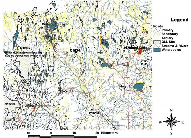
The Whitefish and East Whitefish Lakes Sandy Till Upland Conservation Reserve (C1602) is a 9,353 ha parcel of Crown land that is located within the townships of Robertson, Baden, Sheba, Alma and Michie, within the MNR’s Northeast Region. The nearest community is the Matachewan First Nation Reserve which is adjacent to the Conservation Reserve. The town of Matachewan is 20 km south of the site and Kirkland Lake is 60 km east of the site. The Conservation Reserve can be accessed by means of several harvest roads and trails, many of which are passable by all-terrain vehicle (ATV) only. The majority of the Whitefish and East Whitefish Lakes Sandy Till Upland Conservation Reserve is located in the Kirkland Lake District but two small section in the north extend into the Timmins District. The creation of this Conservation Reserve ensures the protection of sand dunes, bedrock knobs with white pine super-canopy and the bedrock point and cliff faces between Radisson and Currie Lakes. The Whitefish and East Whitefish Lakes Sandy Till Upland Conservation Reserve is in the final stages of regulation and will be managed under a Statement of Conservation Interest (SCI).
SCI documents are the minimum level of management direction established for any conservation reserve and generally are brief management plans. This SCI will govern the lands and waters within the regulated boundary of the Whitefish and East Whitefish Lakes Sandy Till Upland Conservation Reserve. However, to ensure MNR protection objectives are being met within the Conservation Reserve, the surrounding landscape and related activities should consider the site’s objectives and heritage values. In addition, it is the intent of this SCI to create public awareness that will promote responsible stewardship of the protected area and surrounding lands. The MNR, along with management partners such as Ontario Parks, local government and industries, will pursue and advance sound environmental, economic and social strategies and policies related to the protection of conservation reserves and provincial parks.
The purpose of this SCI is to identify and describe the values of the Whitefish and East Whitefish Lakes Sandy Till Upland Conservation Reserve and outline the Ministry’s management intent. The management direction will protect the site’s natural heritage values and demonstrate its compatibility within the larger sustainable landscape. This direction will comply with land use intent as stated by the OLL Land Use Strategy (MNR, 1999).
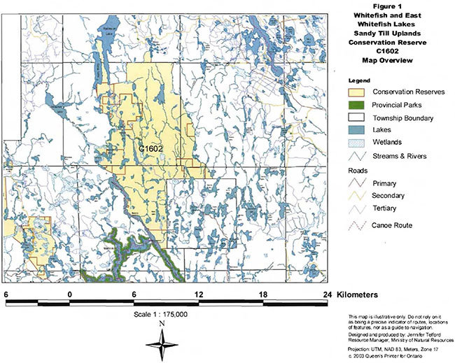
Figure 1.0: Whitefish and East Whitefish Lakes Sandy Till Uplands Conservation Reserve
Enlarge Figure 1.0: Whitefish and East Whitefish Lakes Sandy Till Uplands Conservation Reserve
2.0 Goals and objectives
2.1 Goal of Statement of Conservation Interest
The goal of this SCI is to describe and protect natural heritage values on public lands while permitting compatible land use strategies. This Statement of Conservation Interest is intended to guide the management decisions that will ensure the Whitefish and East Whitefish Lands Sandy Till Upland Conservation Reserve will meet this goal through both short and long-term objectives.
2.2 Objectives of SCI
2.2.1 Short term objectives
The short-term objectives are to identify the State of Resource with respect to natural heritage values and current land use activities for the Whitefish and East Whitefish Lakes Sandy Till Upland Conservation Reserve. A priority will be placed on protection of the site’s natural values via specific guidelines, strategies and prescriptions detailed in this plan. Finally, legislated planning requirements will be met; in particular SCI development will occur within three years of regulation.
2.2.2 Long term objectives
The long-term objectives are to establish representative targets (e.g. future forest conditions) and validate the site as a potential scientific benchmark. To ensure protection of natural and cultural heritage features and values, this SCI will establish an evaluation process to address future new uses and commercial activities associated with them (e.g. Test of Compatibility Procedural Guideline B in Conservation Reserve Policy PL 3.03.05, Appendix #4). Finally, this SCI will identify research/client services and marketing strategies associated with the Whitefish and East White-Fish Lakes Sandy Till Upland Conservation Reserve.
3.0 Management planning
3.1 Planning area
The planning area for this site will consist of the area within the regulated boundary for the Whitefish and East Whitefish Lakes Sandy Till Upland Conservation Reserve (Locator Map, Appendix #7). This land base will form the area directly influenced by this SCI. To fully protect values within the Conservation Reserve, the lands beyond the regulated boundary may require additional consideration within larger land use or resource management plans. Nevertheless, any strategies noted within this plan related to the site’s boundary or beyond will need to be presented for consideration within a larger planning context.
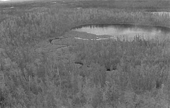
Photo taken during Aerial Reconnaissance, September 2003
3.2 Management planning context
The Whitefish and East Whitefish Lakes Sandy Till Upland Conservation Reserve was first designated as a candidate conservation reserve by MNR in the OLL Proposed Land Use Strategy (MNR March, 1999) and ultimately as a conservation reserve in the final OLL Land Use Strategy (MNR, 1999). This site is in the final stage of regulation. The management and planning direction for this site will follow the OLL LUS (MNR, 1999) as well as this SCI. The area encompassed by this site has been removed from the Timiskaming Forest Alliance Inc. Sustainable Forest License (SFL) land base.
By regulation this Conservation Reserve cannot be used for commercial forest harvest, mining or hydroelectric power development (MNR, 1999). Existing permitted uses within the CR may continue such as fishing, hunting and trapping. This SCI document and future management will resolve conflicts regarding incompatibility between uses and to ensure that identified values are adequately protected.
This SCI will only address known issues or current proposals with respect to permitted uses or potential economic opportunities brought forward to the District Manager during this planning stage. However, in terms of approving future permitted uses and/or development(s), there are established mechanisms in place to address such proposals. Any future proposals will be reviewed using the Procedural Guideline B-Land Uses-Test of Compatibility Public Lands Act Policy PL 3.03.05 (MNR, 1997) (Appendix #4) or other standard MNR environmental screening processes.
Consideration of proposals pertaining to cultural resources may be screened through Conserving a Future for our Past: Archaeology, Land Use Planning & Development in Ontario, Section 3 (MCzCR, 1997), or in processes such as that used by MNR to establish Area of Concern (AOC) descriptions and prescriptions for cultural heritage resources within Forest Management Plans (FMPs).
These planning tools will help refine the review process once the proposal satisfies the direction and intent of the Public Lands Act, associated policies and this Statement of Conservation Interest.
3.3 Planning process
Once a conservation reserve is regulated, the level of management planning required to fulfill the protection targets must be determined. There are two policy documents involved. A Statement of Conservation Interest (SCI) is the minimal requirement for providing planning direction. A Resource Management Plan (RMP) is written when more complex issues arise, such as when several conflicting demands are placed on the resources. The guidelines for the preparation of these documents are outlined in Procedural Guideline A - Resource Management Planning (Conservation Reserves Procedure PL 3.03.05 Public Lands Act). The appropriate plan must be completed within three years of the conservation reserve’s regulation date.
For current planning purposes, the Whitefish and East Whitefish Lakes Sandy Till Upland Conservation Reserve will be managed under the auspices of a Statement of Conservation Interest (SCI). Interested parties from the private and public sector were consulted during the planning process, from candidate conservation reserve to regulation (Appendix #1). The public was widely consulted during the regulation process and further consultation is not required at this time. In addition, a public notification of a draft of this SCI document occurred for a period of 30 days beginning in January 2005 (Appendix #2).
The revised SCI was reviewed by the Kirkland Lake District Manager (DM). Upon approval by the DM the SCI was presented to the Northeast Regional Director (RD) for final approval.
Following RD approval, interested public, user groups and industry were notified that the Statement of Conservation Interest for the Whitefish and East Whitefish Lakes Sandy Till Upland Conservation Reserve was approved.
Public consultation will be solicited as part of any future reviews of land use proposals that would require new decisions to be made. In addition, any future proposal and/or any new, significant management direction considered will be published on the Environmental Bill of Rights Registry (EBR).
The SCI is a management document that will provide background information, identify values to be protected and establish management guidelines for use in the administration of the Whitefish and East Whitefish Lakes Sandy Till Upland Conservation Reserve.
The implementation of the SCI will be the mandate of the MNR at the District level; however, associations with various partners may be sought to assist in the delivery. This SCI is a working document, and as a result, revisions may be necessary from time to time.
4.0 Background information
4.1 Location and site description
4.1.1 Location
The following table describes the location and provides administrative details for the Whitefish and East Whitefish Lakes Sandy Till Upland Conservation Reserve:
Table 1.0: Location data and administrative details
Table 1.0 reformatted into a list
- Name: Whitefish and East Whitefish Lakes Sandy Till Upland Conservation Reserve
- Eco Region - Eco District (Hills, 1959; Crins et. al., 2000): Eco Region 3E, Eco District 5
- MNR Administrative Region/District Area: Northeast Region/Kirkland Lake District in the Elk Lake/Matheson Area (small section in the Timmins District)
- Total Area: 9,353 ha (including forest reserves)
- UTM co-ordinates: 48°07′18″N 80°42′10″w
- Nearest Town/Municipality: Town of Matachewan
- Township (s): Michie, Robertson, Sheba, Baden, Alma
- OBM Numbers: 520053300
- Topographical Map Name/Number: Radisson Lake 42 A/2
- Wildlife Management Unit: 29
- Forest Management Unit: Timiskaming Forest
4.1.2 Site description
4.1.2.1. Physical description
The Whitefish and East Whitefish Lakes Sandy Till Upland Conservation Reserve, which encompasses 9,353 hectares of land, is adjacent to Matachewan First Nation and approximately 20 km north of the Town of Matachewan within Michie, Robertson, Baden, Sheba and Alma Townships (Locator Map, Appendix #7). The Conservation Reserve is within Hills’ eco district 3E, eco region 5 (Hills, 1959). This eco district is characterized by gently rolling plains with thinly covered rock knobs, sandy outwash and silty depressions. Materials are generally granitic, locally overlain by low-base and low-lime materials. Deep deposits cover 25% of the area and the remaining areas have very shallow deposits (Keddie 1997). The eco region, also called the Central Boreal Forest Region, is characterized by flat to gently rolling, glacial clay and sandplain with locally extensive peatlands and wetlands, broken throughout by glacial features such as moraines and eskers with Canadian Shield exposure. Regional vegetation includes spruce, poplar, and birch on fresh sites with moderately sloping terrain, some white and red pine on sand ridges and American elm and white cedar in protected areas. The close association with eco region 4E and the Great Lakes-St. Lawrence forest, results in some sporadic occurrences of species having southern affinities, such as yellow birch, sugar maple and white pine. The forest climate type is mid-humid, mid-boreal (Poser 1992; Noble 1983). For more detailed information relating to the geology of the site refer to Earth Science Inventory, Appendix #9.
The Whitefish and East Whitefish Lakes Sandy Till Upland Conservation Reserve is in Rowe’s (1972) B.7 section (Missinaibi-Cabonga) of the Boreal Forest Region. The B.7 section encompasses the height of land in central Ontario within which the bulk of the forest is boreal but also contains scattered individuals or isolated patches of species from the Great Lakes-St. Lawrence Forest. Predominantly the forest is mixed, consisting of balsam fir (Bf), black spruce (Sb) and white birch (Bw) with scattered white spruce (Sw) and trembling aspen (Pt). Jack pine (Pj) occurs on sand terraces and can also be associated with black spruce on poor, rocky soils. In the wet organic soils black spruce is associated with tamarack (La) and in other lowlands with cedar (Ce). The topography is rolling with numerous flats along the rivers and lake sides.
Within the Whitefish and East Whitefish Lakes Sandy Till Upland Conservation Reserve there is an abundance of early wintering area for moose (Map 3a, Appendix #8). In the early winter moose prefer mature to over-mature mixedwood stands, while in late winter they generally inhabit areas with dense conifer forest communities. Besides early wintering habitat for moose, this CR contains several areas which provide late wintering areas for moose. The East Whitefish River, as well as several other small lakes and creeks along the east and west boundaries, provide suitable moose aquatic feeding areas. Wetlands within the site were classified after Arnup et al. (1999) and Harris et al. (1996), and account for 9.3% of the total area (Forest Resource Inventory wetlands) (Map 3b, Appendix #8). Most of these wetlands are associated with the lakes and creeks in the CR and consist mainly of meadow marsh, shore fens and poor fens. Semi-treed and treed bogs are found north of the Matachewan First Nation Reserve boundary in sand dune areas. Pure black spruce stands were classified as treed bog/conifer swamp and ground surveys would be required to differentiate the two types. Many of the Sb dominant conifer stands were classified as conifer swamp, depending on species composition and/or site class. Floating mats were present on many of the shallow lakes.
4.2 Administrative description
The Whitefish and East Whitefish Lakes Sandy Till Upland Conservation Reserve is in the final stages of regulation (Regulation Maps, Appendix #10). This Conservation Reserve falls within the Elk Lake/Matheson Area of the Kirkland Lake District and will be administered by the Elk Lake/Matheson Area Supervisor. Two small sections in the north of the CR fall within the Timmins District, however Kirkland Lake will be taking the lead on this site. The Crown land surrounding the site is located within the Timiskaming Forest Alliance Inc. Sustainable Forest License (SFL) area.
4.3 History of site
Historically this site has been used by the Matachewan and Temagami First Nations and Teme-Augama Anishnabai Aboriginal Community for hunting, trapping, fishing, baitfish harvesting and fuelwood collecting. These activities continue with two Kirkland Lake district traplines (KL027 & KL028), one Timmins district trapline (T109) and two bear management areas (KL-29-030& Tl-29-013) within the Whitefish and East Whitefish Lakes Sandy Till Upland Conservation Reserve (Map 3a, Appendix #8). A provincially significant native cultural site exists within the Conservation Reserve (OMNR 1973).
Past mining activity has occurred in the area, as is evidenced by a straight line survey to the fault line in the bedrock. During mining exploration the surface layer is removed in order to access the bedrock. This process is usually done in a straight line survey, which is visible on the landscape. Besides mining, logging has also occurred here in the past. Two old harvest blocks are present, the larger of the two (97 hectares) was cut in 1997, the other was cut in 1998 and is 80 hectares in size.
4.4 Inventories
The following table indicates the natural heritage inventories that have occurred or are required in the future.
Table 2.0: Inventory data status
| Type of Inventory | Method | Date | Report Author(s) |
|---|---|---|---|
| Life Science | Aerial Reconnaissance | September, 2003 | B. Burkhardt; OMNR, L. King; OMNR, S. Longyear; OMNR |
| Earth Science | Aerial Reconnaissance & Aerial Photo Interpretation | January, 2005 | R. Kristjansson |
| Recreation | Aerial Reconnaissance | August & September, 2003 | J. Telford; OMNR |
5.0 State of the resource
Representation:
The Whitefish and East Whitefish Lakes Sandy Till Upland Conservation Reserve is dominated by white birch (Bw) mixedwood
The 31 forest communities were re-classified into Standard Forest Units (SFU’s), resulting in 10 SFUs. Of these, four account for less than 1% of the total area (Map 2d, Appendix #8). Using the Standard Forest Unit classification the Conservation Reserve is dominated by BW1 (birch poplar) (23.5% of the total area), MW2 (black spruce/aspen mix) (21.7%) and SB1 (black spruce lowland) (21.0%). BW1 and MW2 incorporated much of the white birch and black spruce mixedwoods. MW2 is concentrated in the north half while BW1 is more common in the southern half. SB1 is generally associated with lowlands/creek systems. SP1 (black spruce/jack pine), PO1 (aspen) and SF1 (spruce/fir/cedar), each accounted for <10% of the total area.
Stocking is defined as an expression of the adequacy of tree cover of an area, or how well trees are distributed across the site (OMNR, 2003). Stocking is usually expressed as a percent value, the higher the percent the more even the distribution pattern. Stocking in this site ranges from 0 to 100+% (Map 2b, Appendix #8). Most of the Bw and Sb pure stands had no stocking and thus were classified as barren-and-scattered, the result of topography or succession stage. Heavily stocked areas are scattered throughout the Conservation Reserve (Map 2c, Appendix #8). The only tamarack stand (La dominant conifer) is aged as high as 165 years old and many of the white birch and black spruce forest communities were aged at 125 to 155 years and are considered old growth, based on Simon et al (2000) definitions (Map 5, Appendix #8). With the above exceptions, the majority of the stands are in the 60-89 age group. During aerial reconnaissance, it was observed that much of the old growth white birch stands were declining.
Not captured in the FRI were the areas of white (Pw) and red (Pr) pine. Red pine was observed along Matachewan Lake, with cedar (Ce) in the understory, as well as on a hill at the north end of the Conservation Reserve. White pine, usually as a super canopy and in association with red pine, are present on the point between Radisson and Currie Lakes.
The Whitefish and East Whitefish Lakes Sandy Till Upland Conservation Reserve contains numerous types of water bodies including, wetlands, streams and small, mid-size and large lakes. Associated with the many lakes and creeks are wetlands which account for 9.3% of the total area. These wetlands consist mainly of meadow marsh, shore fens and poor fens, but semi-treed and treed bogs are also present. Floating vegetation mats exist on many of the shallow lakes.
Portions of the northern half of the Conservation Reserve are located in the 4MB and 4MD tertiary watersheds of the Moose River major basin. The 2JD tertiary watershed of the Ottawa River major basin (OMNR 2002) drains waters in the south direction and it consists of numerous headwater lakes and creeks to the Matachewan Lake/Montreal River system. Northern pike and walleye are found in many of the lakes in the area and lake trout is present in Currie and Radisson Lakes (Map 3a, Appendix #8).
Quality of representation:
The quality of the representation or the current characteristics of the natural features found within a conservation reserve are as important as the overall representative features that are being protected. A number of factors are considered when evaluating a site and they include the following criteria: diversity, condition, ecological factors, special features and current land use activities.
a) Diversity
Diversity
For the Whitefish and East Whitefish Lakes Sandy Till Upland Conservation Reserve, the diversity rating is medium, based on preliminary interpretation of the landforms and the Standard Forest Unit’s. In the original gap analysis conducted by Geomatics International Inc. (Keddie 1997), 47 landform:vegetation (L:V) were categorized, of these 35 were greater than 2 hectares in size and were used in the analysis. The dominant units were mature black spruce on moderately broken outwash uplands, mature black spruce on moderately broken sandy till uplands, mature white birch on moderately broken sandy till uplands and immature white birch on moderately broken outwash uplands. This original gap site was created using original boundaries, after boundary reconfiguration, Ontario Parks (2003) conducted another analysis of the site. In this second survey they found a total of 26 L:V combinations, of which mixed deciduous and mixed coniferous forests on bedrock were the dominant units. Many of the units accounted for <1% of the total area, dropping the diversity rating to low. The forest reserves were not considered in the analysis performed by Ontario Parks. Based on geological interpretation of landforms by Kristjansson (2004), it is estimated there are between 25 to 35 L:V combinations. Wetlands were not considered. The site is dominated by BW1, MW2 on bedrock-drift complex - predominantly till drift cover and SB1 on bedrock-drift complex-unsubdivided.
The forest communities are present in correlation with landforms. Bedrock controlled topography is the dominant landform in the Conservation Reserve. White birch forest communities are present on the upper slopes and ridges while black spruce stands are present on the lowlands. Where ice-contact stratified drift deposits and glaciofluvial deposits occur in the east and west sides, there is a higher concentration of forest communities present.
There are several other features which may alter the diversity rating for this Conservation Reserve. For instance, wetlands were not considered but they account for 9.3% of the total area. Forest community age development stage is another consideration with respect to the diversity rating. Most of the SFUs are represented by all stages of development; immature, mature and old except for SF1, PJ1, MW1 and LC1 which were represented by only two stages. The amount of immature BW1 (pure white birch) and SB1 (pure black spruce) may be misleading since most of these stands were classified as barren-and-scattered and have no age assigned to them. In most likelihood, they are represented by mature and old growth forest communities. Dispersion is a factor which reduces the diversity rating. In this Conservation Reserve MW2 is concentrated in the north half and BW1 is concentrated in the south half with SB1 more apparent in the middle. The other SFUs, although less dominant, are scattered throughout the site.
Evenness refers to the proportion of each cover type and is another measure of diversity. A site is defined as strongly skewed if the top three forest communities capture more than 60% of the site’s area, moderately skewed if they cover 30- 59% or slightly skewed to even if the top three cover less than 30% of the area. A site which contains many cover types of roughly the same size is more diverse than a site with fewer cover types and/or the site has the same number of cover types but one cover type dominates over the others. For the Whitefish and East Whitefish Lakes Sandy Till Upland Conservation Reserve, evenness is strongly skewed towards BW1 (23.5% of the total area), MW2 (21.7%) and SB1 (21.0%) with other units accounting for less than 10% each.
b) Condition:
Condition refers to the amount of disturbance (human and natural) within a conservation reserve. In C1602, condition is rated as medium (i.e. 10-20% of the area is currently under some form of known disturbance). Most of this is related to succession (natural cause). Much of the pure white birch stands are barren and-scattered (less than 30% stocking) and are in a state of decline with conifers growing in the understory. As well, much of the other white birch dominated forest communities are old growth with the white birch declining.
In 1997 a large fire official know as Timmins Fire 12, but more commonly referred to as the Watabeag Fire, burnt almost 5,000 hectares of forest. This fire extended into the southern half of Michie and Norvica Townships, just north of the area now protected by this Conservation Reserve. Numerous small fires in the 1920’s and 1940’s burned sections of forest which now fall within the CR boundaries (Fire Disturbance Map, Appendix #8). Due to the large areas of old growth and high degree of white birch decline, the area is susceptible to forest fires, prescribed burning could be considered to increase the amount of red and white pine in the site.
Other disturbances in the site include a road/trail passing through the site, a hunting camp, an old mining line survey and two harvest blocks (cut in 1997 & 1998). Outside the Conservation Reserve boundary there are numerous harvest blocks, ranging in size from seven hectares to over 200 hectares. The largest cut in the vicinity of this CR is in Sheba township and is 343 hectares, cut in 1988.
c) Ecological factors
Wherever possible, a conservation reserve’s boundaries should be created to include the greatest diversity of life and earth science feature in order to provide maximum ecological integrity. It should be ecologically self-contained, bounded as much as possible by natural features and include adequate area to protect the core ecosystems from adjacent land use activities (OMNR, 1992). Ecological factors refer to the current design of the conservation reserve as noted by its size, shape, and capacity to protect the core land from adjacent land use activities.
This Conservation Reserve is mostly bound by biological features with only a few vectored boundaries. An important design aspect of this CR is the linkage to the Montreal River Provincial Park and ultimately to Mistinikon Lakes Upland Conservation Reserve (C1600) south of this site. This increases representation in protected areas and thus increases diversity.
In 2002, the Ontario Forest Accord Advisory Board (OFAAB) proposed a “Room to Grow” policy. This policy sets out how permanent increases in wood supplies will be shared between new parks and protected areas and forest industry. If this site were to be considered as a “Room to Grow” candidate site there are a few ecological considerations which should be taken into account. The projection between Radisson and Currie Lakes (in the Northwest corner of the CR) has ample water surrounding it to protect it from any external, intrusive forces. Therefore it would be beneficial to remove this projection from the CR and add the same number of hectares in another section, offering protection where it is needed. The other suggestion would be to remove the vectored boundary at the southern tip of Radisson Lake and extend the CR to the creek directly north of the present boundary. This addition could be offset by removing the projection which extends into Michie Township, since this projection provides little benefit to the core habitat. See ‘Ecological Considerations’ Map, Appendix #8.
Currently we do not have minimum size standards for conservation reserves under different landscape conditions. However, a minimum size standard of 2000 ha has been established for natural environment parks by Ontario Parks (OMNR 1992). This minimum standard was considered necessary to protect representative landscapes as well as allow for low intensity recreational activities. Large sites are preferred over small sites as they have greater potential for ecological diversity and stability. Whitefish and East Whitefish Lakes Sandy Till Upland Conservation Reserve, at 9,353 ha, is larger than the Ontario Parks minimum standard. Along with the many biological boundaries of this Conservation Reserve, most of the core areas remain intact and protected from external land use activities.
d) Special features:
The major features present within this Conservation Reserve are:
- sand dunes
- Matachewan Lake with bedrock outcrops, very steep slopes with red pine and cedar understory along the edge
- the bedrock knob ridge near the middle of the site with white birch (birch, maples, some pine) and trembling aspen mixed forest communities and white pine supercanopy on the slopes
- the bedrock point, with some cliff faces, between Radisson and Currie Lakes
- rolling topography from bedrock knobs to black spruce lowlands
e) Current land use activities
Hunting, a historic activity in this area, still continues with a number of temporary hunting structures observed in the site during ground reconnaissance surveys. Currently three trap lines, three baitfish harvesting blocks, and two bear management areas fall within the Conservation Reserve. Pine Martin trap boxes were observed during ground reconnaissance.
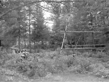
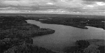
Photo by Jennifer Telford, August 2003
Trails are present within the site and are likely used by hunters and trappers with ATVs, in addition to pleasure riding. A number of ATV riders were seen in the west side of the site during ground reconnaissance in August of 2003. As all surveys were performed in the summer/fall months there are no first-hand accounts of snowmobile use within this site. However, the trails are probably used by snowmobilers in the winter, especially by trappers accessing their traplines. These trails could also be used by hikers; the relatively remote nature of the site providing good back-country hiking opportunities.
Whitefish and East Whitefish Sandy Till Upland Conservation Reserve also provides excellent opportunities for fishing, canoeing and camping. There are a number of areas within this site which have been used for camping, possibly by hunters during the fall. Sport fish are present in a number of lakes within the CR, however the current status of the fishing pressures on these lakes are unknown. Matachewan Lake, on the southwest edge of the site, contains pike and walleye and is accessible by canoe from the West Montreal River with a portage around Old Woman Rapids. Besides Matachewan Lake, East Whitefish, Robertson and a number of smaller lakes within the CR have canoe access.
Summary:
The Whitefish and East Whitefish Lakes Sandy Till Upland Conservation Reserve is a relatively large site with a wide capacity for recreational activities. Access is limited to old logging roads and ATV/snowmobile trails, giving the site a quality of ‘back country’ travel. Human disturbance within the Conservation Reserve is limited to trails and some cleared campsites and rough hunting structures. There is also some evidence of past mining activity and two forest blocks harvested within CR boundaries during the late 1990’s (prior to this area being designated a conservation reserve).
The main features of interest within the Conservation Reserve are; sand dunes, the bedrock outcrops, steep slopes, red pine and understory of cedar associated with Matachewan Lake, the bedrock knob ridge in the middle of the site, the bedrock point with cliff faces between Radisson and Currie Lakes and the rolling topography which ranges from bedrock knobs to black spruce lowlands.
Natural heritage representative features
This site contains upwards of 30 lakes, including East Whitefish, Robertson, and Robb and is bordered by others such as Currie, Radisson, and Matachewan Lakes. Bedrock is the main landform present with a few glaciofluvial ice-contact deposits along the western boundary and glaciofluvial outwash deposits directly north of the Matachewan First Nation (Map 1b, Appendix #8). Old growth mixedwood stands and white birch are located throughout the Conservation Reserve.
Landform - Vegetation (LV) type
Table of Landform-Vegetation combinations to be inserted here. This table is prepared by the Ministry of Natural Resources Regional office and is not available yet.
Table 3.0: Landform:Vegetation Types
Forest Resource Inventory (FRI) Data
- Dominant species, wetlands, and depleted areas
- See Forest Communities Map (Map 2a, Appendix #8)
5.1 Social/economic interest in area
a) Linkage to local communities:
The Whitefish and East Whitefish Lakes Sandy Till Upland Conservation Reserve is situated north of Highway 66 and approximately 20 km north of Matachewan and 60 km west of Kirkland Lake, Ontario. The Conservation Reserve is located within Michie, Robertson, Sheba, Baden and Alma Townships and abuts the Matachewan First Nation Reserve (Locator Map, Appendix #7).
Current uses are related to consumption of fish and wildlife resources and ATV riding. Potential recreational activities include snowmobiling, canoeing, camping, bird watching, photography and hiking.
b) Heritage estate contributions
The Whitefish and East Whitefish Lakes Sandy Till Upland Conservation Reserve contributes to the province’s parks and protected areas system through its regulation, representation and the long-term management of natural heritage values. By allocating these lands to the parks and protected areas system, the province has ensured a certain level of permanence by distinguishing the site and its values from the broader general use or more extensively managed landscape. In addition, its natural features are, and will be available for present and future generations to enjoy and explore.
c) Aboriginal groups
The Whitefish and East Whitefish Lakes Sandy Till Upland Conservation Reserve falls within the Matachewan and Temagami First Nations and the Teme-Augama Anishnabai Aboriginal Community’s identified notification area.
Temagami First Nations and Teme-Augama Anishnabai Aboriginal Community requested that draft copies of this SCI were simply mailed to them. This was done and they were given more than 30 days to provide comments. To date no comments have been received.
MNR staff met with Matachewan First Nations to present this draft SCI and to request their input to this document. A second meeting was scheduled where members of council and the community had the opportunity to voice opinions and influence wording and content of this SCI.
d) Mining interests:
There are five Forest Reserves within the Whitefish and East Whitefish Lakes Sandy Till Upland Conservation Reserve. Forest Reserves are areas where protection of natural heritage and special landscapes are priorities, but some resource use can take place with appropriate conditions. These areas were initially identified for inclusion in conservation reserves but detailed examination determined that existing mining claims or leases existed. The intention is that these lands will be added to the conservation reserve if a mining claim or lease is retired through normal processes. Currently one of these Forest Reserves has an active mining claim (claim number L 983165) with numerous mining leases (100% held by one company). Within the remaining area of the CR, mining and surface rights have been withdrawn from staking under the Mining Act (RSO 1990 Chapter M.14).
e) Forest and fire management history:
Harvesting occurred within the site in 1997 and 1998. The block cut in 1997 was 97 hectares in size and was cut for jack pine and aspen with white birch left standing. The area was planted with jack pine. The second harvest (80 hectares) was a selective-cut southeast of Radisson Lake, the main species harvested was black spruce. The harvest block was left to regenerate naturally resulting in a mixed forest (Burkhardt et al. 2004). Within the past five years there have been three blocks cut in adjacent to CR boundaries, two in Robertson Township, west of the Conservation Reserve boundary and one in Sheba Township north of Matachewan First Nation Reserve and east of the CR boundary. The block in Sheba Township was planted.
The last substantial burn within the CR boundaries was in 1943 (Fire Disturbance Map, Appendix #8). Due to the large areas of old growth and the high degree of white birch decline, the area is susceptible to forest fires. Prescribed burning would perhaps increase the amount of red and white pine in the site.
5.2 Natural Heritage Stewardship
Analysis of the life science targets based on landform:vegetation combinations have shown that the Conservation Reserve contains between 25 and 35 L:V combinations. A total of 31 separate forest communities were identified (Map 2a, Appendix #8), translating into 10 Standard Forest Units (SFU) (Map 2d, Appendix #8). There are numerous old growth stands within the Conservation Reserve; white birch (BW1), lowland conifer (LC1), poplar and birch with spruce mixedwood (MW2), jack pine mixed (PJ2), poplar (PO1), lowland black spruce (SB1) and upland spruce (SP1) (Map 5, Appendix #8). Poplar and birch with spruce (MW2), white birch (BW1) and lowland black spruce (SB1) dominate the site with upland spruce (SP1) and poplar (PO1) complementing the Forest Units. Finally, wetlands account for 9.3% of the total area, further enhancing the site’s natural heritage values and diversity. The majority of the wetland area is classified as treed bog/conifer swamp (Map 3b, Appendix #8).
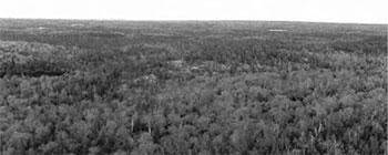
Photo taken by B. Burkhardt, September 2003
5.3 Fish and wildlife
It is believed that sport fish are present in a number of the lakes within the Conservation Reserve. Matachewan Lake, which runs along the southwest edge of the site, contains pike and walleye combination, lake trout as well as small mouth bass. East Whitefish and Robertson Lakes both contain pike. Radisson and Currie Lakes form the boarder of the northwestern-most protrusion of the Conservation Reserve contain lake trout and pike, with walleye being found in Radisson Lake as well (Kirkland Lake District Game & Fish Protective Association, 1993)
This area is used for hunting and trapping. There are two bear management areas (KL-29-030 & Tl-29-013) and three trap line areas (KL027, KL028 & TI09) within the CR. Pine martin trapping boxes and signs of moose, black bear and grouse were observed during ground reconnaissance visits.
5.4 Cultural Heritage Stewardship
To date, little is known about specific cultural resources in this site, as a detailed cultural resource assessment has not been carried out.
5.5 Land use/existing development
The Conservation Reserve is situated entirely on Crown Land and is unencumbered by patented land. It does however, overlap numerous mining leases. Areas which contain active mining leases have been designated as Forest Reserves (Land Use Designation 7.2.3). Policies for Forest Reserves are similar to the policies for new CRs except that mining and related access will be allowed in a Forest Reserves. These areas were initially identified for inclusion in the Conservation Reserve but under detailed examination existing mining leases or claims were discovered. The intention is that these lands will be added to the CR if a claim or lease is retired through normal processes.
Mining and surface rights have been withdrawn from staking within the rest of the Whitefish and East Whitefish Sandy Till Upland Conservation Reserve under the Mining Act (RSO 1990 Chapter M. 14) and no new claims will be allowed to be established within CR boundaries.
5.6 Commercial land use
Present commercial use activities include two bear management areas (KL-29- 030, Tl-29-013) and three traplines (KL027, KL028 & TI09) (Map 3a, Appendix #8). Baitfish harvesting licenses have been issued for the townships within which the Conservation Reserve lies. Existing baitfish harvesting is permitted to continue.
5.7 Tourism/recreation use/opportunities
Some of the features within this site associated with recreational use include; large and small mammals, mixed forests and aquatic fauna. Existing recreational uses in this site and immediately surrounding the site include trapping, large and small game hunting, ATV riding, snowmobiling, and possibly fishing. There is also potential for activities such as bird watching and nature study.
For a more detailed report and summary of recreational use and potential use within the Whitefish and East Whitefish Lakes Sandy Till Upland Conservation Reserve, refer to the Recreational Inventory Report (Appendix #3).
5.8 Client services
Currently, visitor services are limited to; responding to inquiries regarding access, natural heritage features and boundaries. No formal information or interpretive facilities currently exist within the Conservation Reserve. Other services include providing clients with maps, fact sheets, and other information gathered on the area, such as the Earth and Life Sciences Reports and Recreational Inventory work. Enquires for fact sheets, maps and other information concerning conservation reserves within the Kirkland Lake MNR District should be directed to the Kirkland Lake District office.
6.0 Management guidelines
6.1 Management planning strategies
The land use intent outlined in the Ontario Living Legacy Land Use Strategy (OLL LUS, MNR 1999) and the Crown Land Use Policy Atlas (2002) provides context and direction for land use, resource management, and operational planning activities on Crown Land in the planning area and within OLL site boundaries. Commitments identified in the OLL LUS and current legislation (Policy PL 3.03.05 PLA) form the basis for land use within the Whitefish and East Whitefish Lakes Sandy Till Upland Conservation Reserve. Management strategies for these uses must consider the short and long-term objectives for the Conservation Reserve. For up to date information on permitted uses refer to the Crown Land Use Atlas, available online at Crown Land Use Atlas page (Appendix #6).
Proposed new uses and development will be reviewed on a case-by-case basis. A Test of Compatibility, (Procedural Guideline B-Land Uses (PL 3.30.05)), must be completed before proposals can be accepted. In all cases, ensuring that the natural values of the Conservation Reserve are not negatively affected by current and future activities will be the priority. Any application for new specific uses will be carefully studied and reviewed.
6.2 “State of the resource” management strategies
The development of this SCI and the long term management and protection of the Whitefish and East Whitefish Lakes Sandy Till Upland Conservation Reserve will be under the direction of the MNR’s Kirkland Lake District, Elk Lake/Matheson Area Supervisor. The following management strategies have been created to achieve the goal and objectives stated earlier in this management document.
Natural Heritage Stewardship
The management intent for Whitefish and East Whitefish Lakes Sandy Till Upland Conservation Reserve is to allow for natural ecosystems, processes and features to operate undisturbed with minimal human interference while providing educational and potentially research and recreational activities. Forest ecosystem renewal will only be entertained via a separate vegetation management plan. As part of any future vegetation management plan the site and its Site District will be re-evaluated with respect to their known landform/vegetation features to determine if the past harvested areas could contribute additional landform/vegetation values to the Site District.
In addition, the vegetation management plan will need to determine but not be limited to:
- the restoration ecology objectives (e.g. representation) for the area in context with the Site District
- consider current provincial strategies (e.g. management of white pine)
- consider larger long-term conservation reserve (e.g. recreational objectives) and possibly landscape objectives (e.g. contributions to landscape wildlife objectives)
The MNR recognizes fire as an essential process fundamental to the ecological integrity of conservation reserves. In accordance with existing Conservation Reserve Policy and the Forest Fire Management Strategy for Ontario, forest fire protection will be carried out as on surrounding lands.
Whenever feasible, the MNR ’fire program will endeavor to use “light on the land” techniques, which do not unduly disturb the landscape. Examples of “light on the land” techniques include limiting the use of heavy equipment and limiting the number of trees felled during fire response efforts.
Opportunities for prescribed burning to achieve ecological or resource management objectives may be considered. These management objectives will be developed with public consultation prior to any prescribed burning, and reflected in the document that provides management direction for this Conservation Reserve. Plans for any prescribed burning will be developed in accordance with the MNR Prescribed Burn Planning Manual, and the Class Environmental Assessment for Provincial Parks and Conservation Reserves (OMNR, 2004).
Defining compatible uses, enforcing regulations and monitoring and mitigating issues will protect all earth and life science features. Industrial activities such as commercial timber harvest and new hydro generation will not be permitted within the Conservation Reserve. Permits for fuel-wood will not be issued. New energy transmission, communication and transportation corridors or construction of facilities are not permitted within the boundaries of the Conservation Reserve. Such structures negatively impact the quality of the representative features that require protection. Alternatives should be reviewed via larger landscape planning processes. New roads for resource extraction will not be permitted. Other activities that do not pass a Test of Compatibility will be prohibited (MNR Policy PL 3.03.05, 1997).
The intentional introduction of exotic and/or invasive species will not be permitted. Programs may be developed to control forest insects and diseases where they threaten significant heritage, aesthetic, or economic values. Where control is desirable, it will be directed as narrowly as possible to the specific insect or disease. Biological or non-intrusive solutions should be applied whenever possible.
The collection/removal of vegetation and parts thereof will not be permitted; however, subject to a Test of Compatibility, the Elk Lake/Matheson Area Supervisor may authorize such activities for purposes of rehabilitating degraded sites within the reserve, collecting seeds for maintaining genetic stock and/or for inventory for research purposes.
MNR will provide leadership and direction for maintaining the integrity of this site as a heritage estate. To ensure MNR protection objectives are fully met within the Conservation Reserve, activities on the surrounding landscape must consider the site’s objectives and heritage values. Research, education and interpretation will be encouraged to provide a better understanding of the management and protection of the natural heritage values and will be fostered through local and regional natural heritage programs, initiatives and partnerships.
The Whitefish and East Whitefish Lakes Sandy Till Outwash Conservation Reserve will be managed by allowing natural ecosystems, processes, and features to function normally, with minimal human interference.
Fish and wildlife
Fish and wildlife resources will continue to be managed in accordance with specific policies and regulations defined by the Ontario Ministry of Natural Resources under the Fish and Wildlife Conservation Act and the Kirkland Lake District, Elk Lake/Matheson Area Supervisor.
Fishing and hunting are expected to continue at a low level of intensity. Any future trail development will require a Test of Compatibility.
Cultural heritage
When possible, the Ministry of Natural Resources will continue to work with the Ontario Ministry of Culture, Tourism and Recreation in identifying archaeological sites to be protected. To more fully manage and protect sites, the development of field surveys would be required. However, at this time additional field surveys within this Conservation Reserve are not recommended.
Development, research and education proposals may be considered in accordance with the Test of Compatibility and Conserving a Future for our Past: Archaeology, Land Use Planning & Development in Ontario, Section 3 (MCzCR, 1997).
Land use and development
The sale of lands within conservation reserves is not permitted as per the OLL LUS (MNR, 1999). Existing authorized trails can continue to be used and maintained, unless there are significant demonstrated conflicts. New trails will only be allowed if a Test of Compatibility is passed. Any new trail development will require an amendment to the SCI. The cutting of trees for non-commercial purposes (e.g. fuelwood) is not permitted except as required for approved development activity (e.g. trail, viewing site, etc.).
Existing roads can continue to be used, but new roads for resource extraction will not be permitted, with the exception of necessary access for mineral exploration and development within Forest Reserves.
There are no other forms of tenure in the Conservation Reserve other than legal agreements with registered trappers and bear management area operators.
Traditional uses within the Conservation Reserve will continue to be permitted; however, the goal will be to resolve conflicts regarding incompatibility between uses and to ensure that identified values are adequately protected.
Commercial use
All existing commercial bear hunting operations (within BMAs) are permitted to continue. The introduction of new commercial bear hunting operations will not be allowed. The issuance of licenses to provide bear hunting services will be allowed where areas have been licensed or authorized under agreement for the activity since January 1, 1992.
Existing commercial fur harvesting and baitfish harvesting operations are permitted to continue. New operations may be considered subject to a Test of Compatibility.
In these cases “existing use” refers to commercial activities which are supported by an active license, permit or other formal authorization. If this authorization lapses the activity is no longer considered an existing use. However, active licenses can be transferred, transfers include situations where a license is surrendered with a request that it be immediately reissued to another individual or organization that is assuming an existing operation.
Aboriginal interests
The Whitefish and East Whitefish Lakes Sandy Till Upland Conservation Reserve is within three Aboriginal Community’s Area of Interest. The Matachewan First Nation, Temagami First Nation and the Teme-Augama Anishnabai Aboriginal Community have all been consulted at various stages of planning for this Conservation Reserve. Aboriginal and treaty rights will continue to be respected throughout the management of this Conservation Reserve. The members of the Matachewan First Nation are governed by the James Bay Treaty #9. The land encompassed by this CR is governed by the Robinson Treaty. For further details of these treaties please see Appendix 11 (Treaty #9) and Appendix 12 (Robinson Treaty).
Any future proposal(s) and or decision(s) that have potential impact(s) on individual aboriginal values and/or communities will involve additional consultation with the affected aboriginal groups. Neither the regulation of this Conservation Reserve nor the approval of this SCI will have bearing on traditional Aboriginal land uses.
Tourism/recreation
The earth and life science features and their protection shall be the overall theme for tourism. Small-scale infrastructures for enhancing tourism and recreation (i.e., warm-up shelters) may be considered, providing they pass a Test of Compatibility and other MNR requirements.
Most recreational activities that have traditionally been enjoyed in the area can continue, provided they pose no threat to the natural ecosystems and features protected by the Conservation Reserve. These permitted activities include walking, hiking, wildlife viewing, fishing, hunting, and cross-country skiing.
Snowmobiles and all-terrain vehicles (ATVs) are permitted on existing trails and forest access roads within the Conservation Reserve. Under the OLL LUS (MNR, 1999), all mechanized travel is restricted to existing trails. Off trail vehicle use is permitted for the retrieval of game only. New trails can be considered through a Test of Compatibility.
Finally, conflict resolution between recreational uses will be a priority. This will be achieved by adhering to the objectives of this SCI with input from relevant user groups. The level of safety and compatibility between activities will determine permitted uses (i.e. Test of Compatibility).
Client services
Clients indicating their interest in the management planning and future use of this Conservation Reserve will be put on a mailing list and notified of any future planning related to the site.
Present client services such as supplying maps, fact sheets and other information will also continue. Information may be delivered from different sources; however, MNR will be the lead agency for responding to inquiries regarding access, permitted and restricted activities, values and recreation opportunities. A management agreement may be pursued with an appropriate partner to share responsibilities for information services and the delivery of other aspects of this SCI in the future.
6.3 Specific feature/area/zone management strategies
There are no specific management strategies for the maintenance/protection/enhancement of selected resources within the Conservation Reserve. Development of such strategies will require an amendment to the SCI.
6.4 Promote Inventory, Monitoring and Assessment Reporting (IMAR), and research
Scientific research by qualified individuals, which contributes to the knowledge of natural and cultural history, and to environmental and recreational management, will be encouraged.
Additional life science inventory or research may be required to refine values and features. Additional assessment and monitoring of the disturbed areas, including trail and old road locations, within the site should occur prior to any additional management direction being finalized in a vegetation management plan for the area.
Research related to the study of natural processes will be encouraged provided it does not harm the values of the reserve (Procedural Guidelines C - Research Activities in CR, Appendix #5). The Elk Lake/Matheson Area Supervisor or Kirkland Lake District Manager may approve the removal of any natural or cultural specimen by qualified researchers. All such materials removed remain the property of the Ministry of Natural Resources. All research programs will require the approval of the Ministry of Natural Resources and will be subject to Ministry policy and other legislation.
New developments such as campsites, privies, trails or developed access points or activities will not be considered until a Test of Compatibility is conducted and the proposal is approved by the Elk Lake/Matheson Area Supervisor or Kirkland Lake District Manager. The Test of Compatibility or environmental screening process could include a review of the demand for structures or activities and may require more detailed life or earth science or cultural information and possibly more detailed management plan.
Approved research activities and facilities will be compatible with the site’s protection objective. Permanent Sample Plots (PSP’s) or observation stations may be established to which researchers can return over time. Any site that is disturbed will be rehabilitated as closely as possible to its original state.
6.5 Implementation, and plan review strategies
Whitefish and East Whitefish Lakes Sand Till Upland Conservation Reserve SCI will be reviewed on an ongoing basis and as required.
Implementation of the SCI and management of the reserve are the responsibility of the Elk Lake/Matheson Area Supervisor. Partnerships may be pursued to address management needs.
If changes in management direction are needed at any time, the significance of the changes will be evaluated. Minor changes that do not alter the overall protection objectives may be considered and approved by the District Manager without further public consultation and the plan will be amended accordingly. In assessing major changes, the need for a more detailed Resource Management Plan will first be considered. Where a Resource Management Plan is not considered necessary or feasible, a major amendment to this SCI may be considered with public and aboriginal consultation. The Regional Director must approve major amendments.
6.6 Marketing strategies
Whitefish and East Whitefish Lakes Sandy Till Up land Conservation Reserve Whitefish and East Whitefish Lakes Sand Till Upland Conservation Reserve will be marketed as a representative natural area having earth and life science values, as well as certain recreational values. Marketing efforts to increase use are not a priority and will be kept to a minimum.
6.7 Boundary identification
There is no stated policy to mark the boundaries of a conservation reserve. Local management discretion can be used to determine where boundary marking may be appropriate. In order for restrictions to be enforceable, signs must be placed in accordance with the Trespass to Property Act or subsection 28 (1) of the Public Lands Act to advise against any recreational activities.
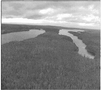
Photo taken by J. Telford, September 2003
7.0 References
Arnup, R., G.D. Racey and R.E. Whaley. 1999. Training manual for photo interpretation of eco-sites in northwestern Ontario. NWST Technical Manual TM-003. 127p
Burkhardt, B., King, L., and Longyear, S. 2004. Natural Heritage Area - Life Science Report - C1602.
Crins, W.J. and P.W.C. Uhlig. 2000. Eco-regions of Ontario: Modifications to Angust Hill’s Site Regions and Site Districts - Revisions and Rationale.
Harris, A.G., S.C. McMurray, P.W.C. Uhlig, J.K. Jeglum, R.F. Foster and G.D. Racey. 1996. Field guide to the wetland ecosystem classification for northwestern Ontario. Ont. Min. Natur. Resour., Northwest Sci. & Technol. Thunder Bay, Ont. Field Guide FG-01. 74p +append.
Hills, G.A. 1959a. A Ready Reference to the Description of the Land of Ontario and its productivity.
Hills, G.A. 1959b. Hills Mapping.
Keddie, C. 1997. Natural Heritage Gap Analysis for Site District 3E-5 : GIS Analysis by Geomatics International Inc.
Kristjansson, R. 2004. Earth Science Planning Summary - Whitefish and East Whitefish Lakes Sandy Till Upland (C1602) and aerial landform/surfical material interpretation.
Ministry of Citizenship, Culture and Recreation. 1997. Archaeology, Land Use Planning & Development in Ontario: An Education Primer and Comprehensive Guide.
Nobel, T.W. 1983. Central Boreal Forest Region (3E). Life Science Report. Northeastern Region. Internal Report.
NTS topographic mapping (Radisson Lake 42A/2).
OFRI. 1994a. Boreal East Landforms Mapping - Satellite Imagery.
Ontario Ministry of Natural Resources. 1992. Ontario Provincial Parks: Planning and Management Policies. 1992 Update.
Ontario Ministry of Natural Resources. 1999. Ontario’s Living Legacy Land Use Strategy, Queens Printer for Ontario, Toronto, ON.
Ontario Ministry of Natural Resources. 1983. Kirkland Lake District Land Use Guidelines.
Ontario Ministry of Natural Resources. 1:20 000 1994 Air Photos.
Ontario Ministry of Natural Resources. 1995. Forest Resource Inventory Mapping (Ages Corrected).
Ontario Ministry of Natural Resources. 1997c. Ontario Watershed Mapping.
Ontario Ministry of Natural Resources. Lakes 1:600 000 Mapping.
Ontario Ministry of Natural Resources. MTO Roads 1:600 000 Mapping.
Ontario Ministry of Natural Resources. Patent 1:600 000 Mapping.
Ontario Ministry of Natural Resources. Railway 1:600 000 Mapping.
Ontario Ministry of Natural Resources. Townships 1:600 000 Mapping.
Ontario Ministry of Natural Resources. Transmission Lines 1:600 000 Mapping.
Poser, S. 1992. Report of the status of provincial parks in the site region and districts of Ontario. Ministry of Natural Resources Report.
Rowe, J.S. 1972. Forest Regions of Canada. Department of Fisheries and Environment-Canadian Forestry Service Publication No. 1300.
Taylor, K.C., R.W. Arnup, B.G. Merchant, W.J. Parton and J. Nieppola. 2000. A Field Guide to Forest Ecosystems of Northeastern Ontario. 2nd ed. Northeast Science and Technology NEST Field Guide FG-001.
Thompson, John E.& Jake Noordhof. 2003. Edit Model for N.E. Region Life Science Checksheets. Internal Report.
Van Schip, Bill. 2004. Personal Conversation.
Appendix 1: Public consultation summary
| Date Received | Client | Comment | Action Taken | Date of Response |
|---|---|---|---|---|
| 17-Jan-05 | #1 | Request for copies of draft SCI for C1602 and C1596 | Package made available at front counter for pick-up by client | 17-Jan-05 |
| 12-Jan-05 | #2 | Member of the Fish & Wildlife Advisory Committee called requesting copies of SCI’s for C1602, C 1596, C1714 | Copies were made and mailed. | 13-Jan-05 |
| 15-Nov.- 04 | #3 | Temogami FN, Matachewan FN and Teme-Augama Anishnabai were contacted with regards to completion of draft SCIs | Package of draft SCI’s to be sent to Temogami and Teme-Augama Anishnabai. Meeting to be arranged with Matachewan. | 15-Nov.- 04 |
| 16-Dec.- 03 | #4 | Matachewan FN informed that MNR is moving ahead with steps recommending seven OLL sites become regulated (including C1602) and that any further discussion could be direct to the KL District Planner. | Regulation Process is on-going | 16-Dec.- 03 |
| 31-July- 03 | #5 | Letter sent from MNR to Matachewan FN indicating MNR will be performing the Recreation Inventory for C1602, among others. | Recreation Inventories were carried out in August 2003 | 31-July-03 |
| 12-June- 03 | #5 | OLL meeting with Matachewan FN discussing the boundaries of C1602 (among other CRs). There were some concerns around potential impacts to mining. It was suggested they outline concerns around mining in a letter which also should outline any boundary issues. | No such letter was received, so a letter was sent from the MNR requesting they forward any concerns to the KL office as soon as possible | 31-Oct.-03 |
| 15-July-03 | #7 | Client requested information on C1602 and inquired as to why it was chosen as an OLL site. He was in the area for a few weeks and requested a package of information be put together. | Package was put together and left at front desk for him to pick up. | 16-July-03 |
| 08-Feb- 01 | #8 | Requested maps and some info regarding all OLL sites, he was speaking on behalf of a snowmobile club. He was asking about trails and development of new trails for the purpose of snowmobiling | He was sent via mail, info on existing and new trails, as well as provided with the strategy and all 26 site maps | 08-Feb-01 |
| 14-Dec.-00 | #9 | General discussion held with Matachewan FN with regards to permitted uses - i.e. restrictions on timber harvesting, aggregate extraction, hydro development and restrictions on mining and staked mining claims. Comments from Band Members supporting new P.P and C.R. wanted to ensure there would not be any impediment on native rights, and wanted it written in bold letters. | Comments were dually noted. A short review of Lands for Life and OLL process was given, a handout was provided for the members in attendance | 14-Dec.-00 |
| 22-Nov.-00 | #10 | Phone conversation with Matachewan Band Councillor regarding the need to move ahead with regulation process. Concern that we had not heard from them with regards to boundaries. | Offered to mail a second set of maps if need be. | 22-Nov.-00 |
| 3-Oct.-00 | #11 | OLL Presentation at the KL Local Citizens Committee. Concerns raised regarding deadline - felt they were not given enough time to read over material. | An overview of the protected areas was given, discussed permitted uses within CR, if LCC members were interested in a specific site they can come/write/call KL district office | 3-Oct.-00 |
| 11-Sept.-00 | #12 | Client had some comments/questions with respect to his current Mining Claims, some of which are located within new OLL protected areas. He is concerned that no company would want to buy these areas now that they are in protected areas, he was also curious in regards to compensation. The client was also unsure what was meant by ‘careful exploration’ as stated in the OLL land us strategy. | Client was directed to the regional OLL contact for more information with regards to OLL and mining claims compensation | 11-Sept.-00 |
| 08-Sept.-00 | #13 | Client was concerned that MNR will not be able to monitor and protect the newly proposed protected areas because of the staff shortage. | A package of the 26 sites which were currently being proposed for OLL sites was sent to the client and she was put on the OLL mailing list. | 08-Sept.-00 |
| 05-Sept.-00 | #14 | Client was interested in some information describing four OLL areas (including C1602), receiving any maps available of the areas and boundaries and some general information on Ontario’s Living Legacy. | Client was phone and a package of information was sent by mail | 06-Sept.-00 |
Appendix 2: Public consultation ad
Review of draft Statements of Conservation Interest
C1596 Whitefish River Sandy Till
C1602 Whitefish and East Whitefish Lakes Sandy Till Uplands
C1626 South Grassy Lake Outwash
C1714 MacDougal Point Peninsula
The Ministry of Natural Resources (MNR) invites you to review the draft Statements of Conservation Interest (SCI) for the Whitefish River Sandy Till, Whitefish and East Whitefish Lakes Sandy Till Uplands, South Grassy Lake Outwash and MacDougal Point Peninsula Conservation Reserves. Copies of these draft documents will be available for review at the Kirkland Lake District MNR office until February 21st, 2005.
The Whitefish River Sandy Till Conservation Reserve is situated 18 km northwest of the town of Matachewan. This Conservation Reserve is located within the townships of Cleaver, McNeil, Hincks, Argyle and Bannockburn and is 3,399 hectares in size. The Whitefish and East Whitefish Lakes Sandy Till Uplands Conservation Reserve is situated 20 km north of Matachewan and approximately 65 km west of the town of Kirkland Lake. This Conservation Reserve is located within Robertson, Baden, Sheba, Alma and Michie townships and is 9,353 hectares in size. The South Grassy Lake Outwash Conservation Reserve is found 17 km southeast of Kirkland Lake. This Conservation Reserve is located within McElroy and Hearst Townships and is 425 hectares in size. The MacDougal Point Peninsula Conservation Reserve is located 65 km north of Kirkland Lake and 45 km east of Iroquois Falls, in Rand, Frecheville and Stoughton townships. This Conservation Reserve is 6,035 hectares in size.
The Statements of Conservation Interest identify area values and provide direction on resource management activity and appropriate land uses. As conservation reserves, commercial activities such as forest harvesting, mining and hydroelectric power development are prohibited from occurring within the protected area. The Ministry of Natural Resources (MNR) is collecting comments and information regarding the draft Statements of Conservation Interest under the authority of the Public Lands Act (1990) to assist in making decisions and determining future public consultation needs. Comments and opinions will be kept on file for use during the plan’s operating period and may be included in the study documentation, which is made available for public review.
Under the Freedom of Information and Protection of Privacy Act (1987) personal information will remain confidential unless prior consent is obtained. However, this information may be used by the Ministry of Natural Resources to seek public input on the other resource management surveys and projects. For further information on this Act, please contact Shaun Walker at
If you would like additional information or would like to supply background information or viewpoints to be considered by the planning team, please contact:
Jessy Malone or Jody Bissett
Land Use Planners
Ministry of Natural Resources
Kirkland Lake District
P.O. Box 910, 10 Government Road East
Kirkland Lake, ON
P2N 3K4
Comments will be accepted until February, 21st, 2005
Renseignement en français:
Appendix 3: Recreational inventory checksheet
Recreation inventory report
Whitefish and East Whitefish Lakes Sandy Till Uplands Conservation Reserve C1602
December 2, 2003
Prepared For: OMNR, Northeast Region
Jennifer Telford
Kirkland Lake District, OMNR
Introduction
The Whitefish and East Whitefish Lakes Sandy Till Uplands Conservation Reserve is located in northeastern Ontario approximately 60 kilometres from the Town of Kirkland Lake.
Conservation Reserves identified in Ontario’s Living Legacy Land Use Strategy (LUS) were given interim protection and the intention is to have all of the sites formally regulated under the Public Lands Act by 2004. The process to regulate the Whitefish and East Whitefish Lakes Sandy Till Uplands Conservation Reserve is currently underway, and regulation is expected in the spring of 2004.
In addition to the regulation process, a number of inventories, including a Recreation Inventory Report, are being conducted in the Living Legacy sites. Recreation inventories are particularly important to the OLL planning process, as one of the major objectives of the LUS is to ensure that a broad range of natural resource-based recreation opportunities are provided for. As a result the Ontario’s Living Legacy Guidelines for Recreation Assessment were developed. Under the guidelines all inventories are guided by four basic objectives:
- Identify landforms and features, which are or may be used for recreation
- Identify the range of settings that the protected area is able to provide
- Identify all known existing recreational activities
- Identify all means by which the protected area can be accessed
The Whitefish and East Whitefish Lakes Sandy Till Uplands Conservation Reserve Inventory was influenced by the four basic objectives but it also attempts to evaluate the impact of humans in the site.
Figure 1: Whitefish and East Whitefish Lakes Sandy Till Uplands Conservation Reserve C1602 Map Overview
3.0 Description of the study area
3.1 General setting:
The Whitefish and East Whitefish Lakes Sandy Till Uplands Conservation Reserve is situated in the Townships of Robertson, Baden, Sheba, Alma and Michie. The conservation reserve covers an area of approximately 9350 hectares. The nearest community is the Matachewan First Nation which is located next to the conservation reserve. The nearest town is the Town of Matachewan located about 20 kilometres from the site.
A few other protected areas are within close proximity to the site. These areas are all Ontario Living Legacy Conservation Reserves. The Mistinikon Lake Uplands and Dunmore Township Balsam Fir Outwash Deposit Conservation Reserves have already been regulated and the Whitefish River Sandy Till Conservation Reserve will be regulated at the same time as this site. The West Montreal River Provincial Park is also nearby and was regulated in 2002.
3.2 Cultural values:
Little is known about the cultural values of the conservation reserve. The Matachewan First Nation has an interest in the land because it is located next to their reserve. The site is part of their traditional land use area and has been used for hunting, fishing and trapping by the First Nation Community for many years.
3.3 Life science values:
The life science evaluation for this site has not yet been completed. Tree species observed in the site include black spruce, white birch, jack pine and poplar. Old growth larch and yellow birch are also associated with the site (OLL Factsheet, 2002). The dominant species in the site are black spruce and white birch with a large percentage of these species being 80+ years in age. The vegetation communities present within the conservation reserve are representative of ecological site district 3E-6.
3.4 Earth science values:
The dominant landforms for this site are moderately broken outwash uplands of lacustrine fine sand and moderately broken shallow sandy till uplands of lacustrine fine sand and clay.
4.0 Methodology
Primary and secondary resources were used to gather information for this recreation inventory report. Primary research consisted of field site visits and discussions with district staff. Secondary research was done prior to field visits.
Table 1: Summary of information sources
| Primary Research | Secondary Research |
|---|---|
| Two ground visits (August 27, 28, 2003) | Internal OLL documents |
| Aerial visit (September 24, 2003) | OBM and OLL Maps |
| Contact with District staff | Air Photos |
The two ground visits were each a day in length and covered as much of the site as possible. The ground visits were made with a four-wheel drive truck and ATVs. Most of the travel done within the Conservation Reserve was by ATV. Land routes and road access were documented with a GPS unit and digital photographs were taken of interesting features. Water routes were not explored due to lack of access to most lakes or the inability to transport any form of water craft into the site with the equipment being used to survey the site (ATVs).
Information gathered from the site visits was then used to complete the recreation checklist (Appendix A). The checklist was completed in accordance with the Ontario’s Living Legacy Guidelines for Recreation Resource Assessment, Version 3 - May, 2002 and data was entered into the Microsoft Access form provided. A map of the site was created using the site access information gathered from the GPS unit.
5.0 Recreation features
Recreation features are biophysical or cultural attributes that may be able to support recreational activity. A total of six features were recorded and ranked according to their recreational value and importance in the Recreation Inventory Checklist (Appendix A). Listed features have a corresponding code and are classified under a specific category according to the Ontario’s Living Legacy Guidelines for Recreation Resource Assessment, Version 3 - May, 2002. The following sections provide more detail on each of the features.
5.1 Land routes (T03) - Trails or routes
Access to the site is through logging roads and trails. Access can only be gained by ATV on most of the roads and trails. One main trail extends from the Matachewan First Nation Reserve up to Radisson Lake. This trail is passable by truck for only a kilometre or two. The rest of the trail can be accessed by ATV with the last few hundred metres to Radisson Lake by walking access only.
There are a number of trails that are attached to the main trail. These trails provide a number of travelling opportunities for the ATV enthusiast. Since the site visit was performed in the summer it is unclear if any or all of the trails observed are used for snowmobiling as well. Additional field visits are suggested to map the numerous side trails and to establish if the trails are used in the winter.
5.2 Sport fish (A01) - Aquatic Flora/Fauna:
Although there are several lakes and streams found within this Conservation Reserve, little is known about the current state of the fisheries of those lakes. Fisheries information is not available for most of the lakes at this time. Some information does exist on Matachewan Lake, which borders the site. The lake contains walleye, northern pike and lake trout. There is access to the East Whitefish River, East Whitefish Lake, and Radisson Lake from within the conservation reserve. There is also access to a few small, unnamed lakes. Research is required on the lakes within the conservation reserve to determine the current state of the sport fish.
5.3 Large land mammals (W03) - Wildlife:
The site contains moose and black bear. Moose were observed within the site during aerial visits and evidence of both moose and bear were observed during field visits. Moose and black bear tracks were observed on trails in the site. The site contains one Bear Management Area and District staff are aware of both moose and bear hunting in the area.
5.4 Waterbodies (M00) - Waterbodies:
The Whitefish and East Whitefish Lakes Sandy Till Uplands Conservation Reserve contains many types of waterbodies including wetlands, streams, and small, mid-size and large lakes. The major water features are East Whitefish Lake, East Whitefish River, Radisson Lake, Currie Lake and Matachewan Lake. The latter three only border the site but may provide better access to fishing enthusiasts.
5.5 Shore Features (800) - Shore features:
The many lakes and streams in the site provide a variety of shore features. The shore of Radisson Lake, as well as other lakes, has the potential to provide users with camping and fishing opportunities.
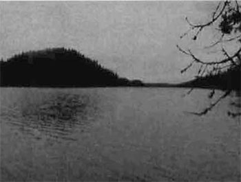
5.6 Wetland vegetation (E08) - Vegetation features:
The lakes and streams within the site provide excellent opportunities for wetland vegetation along their shores and banks. Many wetland areas were observed during ground and aerial visits.
6.0 Recreation activities
The recreation activities are closely related to the recreation features. Eight activities were recorded on the Recreation Inventory Checklist when the inventory was performed. Activities were selected from a list of known recreation activities included in the Ontario’s Living Legacy Guidelines for Recreation Resource Assessment, Version 3 - May , 2002. The activities have a corresponding code and the existing activities were differentiated from potential activities by using a capital letter in their activity code. The following eight sections provide more details on each of the activities.
6.1 Hunting (H00) - Hunting/trapping:
The Whitefish and East Whitefish Lakes Sandy Till Uplands Conservation Reserve has been used as a traditional hunting area by members of the Matachewan First Nation for many years. A number of temporary structures were observed during ground reconnaissance. Moose, black bear and grouse would be hunted in the site. Moose were observed in the site during aerial visits.
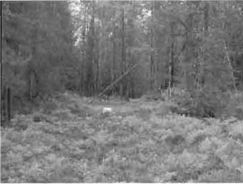
6.2 Trapping (H06) - Hunting/trapping:
There are two registered traplines within the Conservation Reserve. One of the traplines follows the main trail from the First Nation Reserve to Radisson Lake at the northern tip of the site. Marten boxes were observed on the trail and it is assumed that the trapline is accessed by snowmobile in the winter.
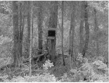
6.3 ATV (T01) - Travelling:
Most of the trails found within the Whitefish and East Whitefish Lakes Sandy Till Uplands Conservation Reserve are only passable by ATV. Numerous tracks were observed during the field visit. Also, a number of riders were observed in the west side of the site during the ground reconnaissance in August of 2003.
6.4 Fishing - General (f00) - Fishing:
It is believed that sport fish are present in a number of the lakes within the Conservation Reserve. The current status of the fisheries in these lakes and the fishing pressure on the lakes is unknown. Many of the lakes may only be accessed in the fall during the hunting season. Matachewan Lake on the southwest edge of the site contains pike and walleye and is accessible by canoe from the West Montreal River with a portage around Old Woman Rapids.
6.5 Snowmobiling (d10) - Snow sports:
Since the field visits to this site were performed in the summer, it is difficult to determine the amount of snowmobile use. It is likely that the ATV trails are used for snowmobiling in the winter. The trap line is likely accessed by snowmobile.
6.6 Camping activities - General (K00) - camping:
There are a number of areas within the conservation reserve that have been used for camping. Most of the camping in the Whitefish and East Whitefish Lakes Sandy Till Uplands Conservation Reserve would be done in the fall during the hunting season.
6.7 Canoeing (b02) - Water sports:
There are a number of lakes within or bordering C1602 that can be canoed. East Whitefish Lake, Robertson Lake and a number of smaller lakes within the conservation reserve do have access. Also, Matachewan Lake on the western edge of the conservation reserve is associated with the West Montreal River canoe route. The lake can be accessed by travelling north on the West Montreal River by canoe. There are two portages around rapids and the length of these portages is not known at this time. There is also a trail up to a dam site. Currently, the condition of the trail is not known. It is possible that the trail is accessible by four-wheel drive truck. The Matachewan Dam is found on the west side of the lake across from the southern tip of the conservation reserve. The dam provides a scenic set of rapids.
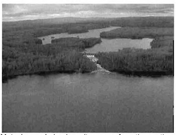
6.8 Hiking (t08) - Travelling:
The numerous trails within the conservation reserve provide excellent prospects for hiking. It is not known if hiking is currently done in the conservation reserve. The site could provide hikers with a number of trails, most of them being easy hikes. The site is not easily accessible and would provide hikers with good backcountry hiking opportunities.
7.0 Recreation factors
The recreational factors provide a context for the information collected during the recreation inventory, as they are meant to provide some insight on how the site will contribute to outdoor recreation at the regional level.
7.1 Feature significance:
Feature significance for the conservation reserve, which is a composite measure of feature scarcity and uniqueness, activity attraction capability, scenic attractiveness, and geographic significance, was rated as low. This designation resulted from the fact that no factors rated above low.
The most scarce feature in the conservation reserve is sport fish. It is listed as scarce only because there is not any current information on the state of the fisheries in any of the lakes within the site. We believe that many of the lakes may contain sport fish species but without the necessary data we cannot accurately identify sport fishery lakes. We also do not know what the fishing pressure on any of the lakes within the site may be. The fishing pressure is most likely low because of the distance of the site from any large settlement and the inaccessibility of the site. However, data for the lakes in the site should be collected to properly assess the fishing potential of the conservation reserve.
The features of C1602 are all common to the area so, a unique feature has not been chosen.
The activity attraction capability, scenic attractiveness and geographic significance are all rated low for this site. The site is not easy to reach and is geographically similar to most of this area.
7.2 Feature sensitivity to recreation use:
The most sensitive feature to recreation use is the shore features. There is not a lot of attractive shoreline within the conservation reserve and therefore the areas of nice shoreline could be overused. The shorelines and the lakes would be sensitive if they were subjected to a large increase in recreation. There is the potential of shoreline damage from ATV use within the conservation reserve. Hunters and ATV enthusiasts could damage riparian areas by crossing creeks and streams. The sensitivity of this feature has been rated as low for recreation use because the conservation reserve is not easy to reach.
7.3 Feature sensitivity to resource development:
A feature sensitive to resource development has not been chosen. The site is remote and not likely to have development occur in or near it in the foreseeable future.
7.4 Cultural/historic and archaeological features:
The Whitefish and East Whitefish Lakes Sandy Till Uplands Conservation Reserve was rated as having cultural features since the Matachewan First Nation is located next to the conservation reserve and is part of their traditional land use area.
8.0 Recommendations
Upon completion of this first phase of recreational assessment, a series of recommendations were made. The recommendations are as follows:
8.1 Additional research:
- Field visits should be made in the winter months to determine if the trails are used for snowmobiles
- The exact location of all trails within the conservation reserve should be determined with a GPS unit and mapped accordingly
- The lakes and rivers should be researched to determine what types of fisheries exist within the conservation reserve and the fishing pressure in the site (if any) needs to be determined
8.2 Future management:
- Existing trails need to be mapped in order to enforce the LUS permitted uses with respect to new trails within OLL conservation reserves
- Consultation with regards to additional research in the conservation reserve should remain ongoing between the Ministry of Natural Resources and the Matachewan First Nation
References
Mulrooney, Dan. Ontario’s Living Legacy Guidelines for Recreation Resource Assessment, Version 3- May 2002. Ontario Parks, May 2002.
Ontario Ministry of Natural Resources. Whitefish and East Whitefish Lakes Sandy Till Upland Conservation Reserve (C1602) Factsheet, September 2002.
Recreation Inventory Checklist
- Name: C1602 Whitefish and East Whitefish Lakes Sandy Till Upland
- Map Name: Raddisson Lake
- NTS Number:: 42A/2
- UTM reference:: 522533
- OBM Number: 523/5332
- Latitude: 48 07’ 10"N
- Longitude: 80 42’ 10’W
- Area (ha): 9,350.00
- Ownership: Crown
- MNR Region: Northeast
- MNR District: Kirkland Lake
- Park Zone: Northeast
- Count:
- Township: Robertson, Baden, Sheba, Alma, Michie
- Recreation:
- T03 - Land Routes
- A01 -Sport Fish
- W03 - Land Mammals, Large
- M00 - Waterbodies, General
- B00 - Shore Features, General
- E08 - Wetland Vegetation
- Recreation:
- h00 - Hunting
- H06 - Trapping
- t01 - ATV
- f00 - Fishing, General
- d10- Snowmobiling
- k00 - Camping Activities, General
- b02 - Canoeing
- t08 - Hiking
| Recreation | Features | Rating: Very High, High, Moderate, Low, N/A |
|---|---|---|
| Most scarce feature: | 2 | N/A |
| Feature scarcity: | N/A | Low |
| Most unique feature: | N/A | N/A |
| Activity attraction capability: | N/A | Low |
| Scenic attractiveness: | N/A | Low |
| Geographic significance: | N/A | Low |
| Feature significance: | N/A | Low |
| Most sensitive feature to recreation | 5 | N/A |
| Feature sensitivity to recreation use: | N/A | Low |
| Most sensitive feature to resource | N/A | N/A |
| Feature sensitivity to resource development: | N/A | N/A |
| Cultural/historic and archaeological features: | N/A | C |
Comments: The nearest community to this Conservation Reserve is the Matachewan First Nations.
Date compiled:
Thursday Nov. 13th, 2003
Compiler:
Jennifer Telford
Source: Recreation Resource Inventory Standards and Procedures Draft Report, Gov. of British Columbia, Ministry of Forests Range, Recreation and Forests Practices Branch, March 1995.
Ontario Ministry of Natural Resources, Ontario Parks
300 Water Street, Peterborough, Ontario K9J 5N1
Appendix B: Map of Ontario’s Living Legacy Sites in the area of C1602
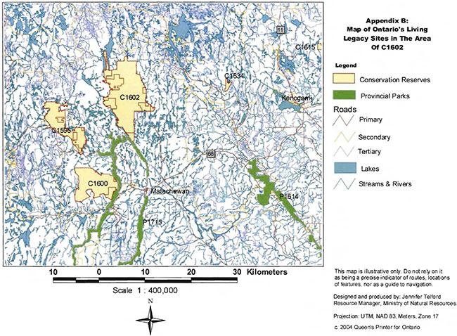
Enlarge Map of Ontario’s Living Legacy Sites in the area of C1602
Appendix C: Wildlife Management Areas in C1602
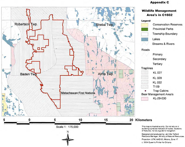
Enlarge Map of Wildlife Management Area’s in C1602
Appendix D: C1602 Wildlife Areas
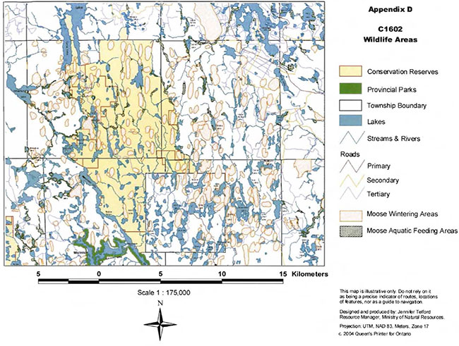
Enlarge Map of C1602 Wildlife Areas
Appendix E - Whitefish and East Whitefish Lakes Sandy Till Upland Conservation Reserve - C1602: Fact sheet
September 2000
Background
On July 16, 1999, the Ontario Government released the Ontario’s Living Legacy Land Use Strategy to guide the planning and management of Crown lands in central and parts of northern Ontario. A major part of the Ontario’s Living Legacy Land Use Strategy was a government intent to establish 378 new protected areas. This commitment marks the biggest expansion of provincial parks and conservation reserves in Ontario’s history. The proposed Whitefish and East Whitefish Lakes Sandy Till Upland Conservation Reserve is part of the significant expansion of Ontario’s protected areas system.
Size and location
The Whitefish and East Whitefish Lakes Sandy Till Upland Conservation Reserve, consists of approximately 10,530 hectares of land. This site is found in Baden, Alma, Robertson, Michie, Sheba Townships in the District of Timiskaming.
Area highlights
Two landforms dominate this candidate area. Moderately broken outwash uplands of lacustrine fine sand dominated by moderate to old growth of black spruce and all three-age classes of poplar/aspen. Old growth larch is also associated with the site. A second dominant landform, moderately broken shallow sandy till uplands of lacustrine fine sand and clay, also occurs. Here black spruce (31 to 100 years old), moderate and old age white birch, jack pine, and poplar/aspen stands dominate the landscape. Old growth yellow birch and larch are also associated with this landform. Old growth white pine stands were observed around Whitefish Lake.
Land use intent
Out post camps are currently situated in the site, their use will be permitted to continue upon regulations of the site. Conservation reserves are areas of Crown land set aside by regulation under the Public Lands Act. Conservation reserves complement provincial parks in protecting representative natural areas and special landscapes. Most recreational; (e.g. hiking, skiing, tourism related uses, nature appreciation) and non-industrial (e.g. fur harvesting, commercial fishing and bait fishing) activities that have traditionally been enjoyed in the area will continue, provided that these uses do not impact on the natural features needing protection. Hunting and fishing are permitted within all new conservation reserves proposed through Ontario’s Living Legacy. Commercial timber harvesting, mining, aggregate extraction and commercial hydroelectric development are prohibited in conservation reserves. Careful mining exploration may occur in specific conservation reserves proposed through Ontario’s Living Legacy, in areas that have provincially significant mineral potential. If a portion of a new conservation reserve is to be developed for a mine, it would be removed from the reserve, and appropriate replacement lands would be placed in regulation.
Next steps
The Land Use Strategy established the Ministry’s intent to add these Crown lands to Ontario’s protected areas system, following the extensive public consultation associated with the Ontario’s Living Legacy and Lands For Life land use planning initiatives between 1997 and 1999. Prior to the finalization of the boundary of this conservation reserve proposed for regulation under the Public Land Act, the Ministry is inviting public comment on the proposed boundary from all potentially affected stakeholders and First Nations. In the interim, the area has been withdrawn and protected from resource extraction activities such as timber harvesting, hydroelectric development, aggregate extraction and new mineral exploration. In the future and subject to the intended regulation of the area as a conservation reserve, the Ministry of Natural Resources will prepare long term management plan for this area. Depending upon the complexity of issues within this conservation reserve, management planning may take the form of a simple Statement of Conservation Interest or a more detailed Resource Management Plan. Please let us know if you would like to be notified when planning begins. Planning, management and the uses permitted within the conservation reserve would be consistent with the commitments of the Ontario’s Living Legacy Land Use Strategy.
For more information
For further information on the proposed Whitefish and East Whitefish Lakes Sandy Till Uphill Conservation Reserve, please contact: Shaun Walker, District Planner Ministry of Natural Resources Kirkland Lake District, telephone: 705-568-3231; email: shaun.walker@mnr.gov.on.ca [inactive]. You may also visit the Ministry’s website for more information about Ontario’s Living Legacy.
Appendix 4: Procedural Guideline B - Land Uses - Test of Compatibility (PL Procedure 3.03.05)
The Conservation Reserve policy provides broad direction with regard to the permitted uses. The policy provides only an indication of the variety of uses that will be considered acceptable in Conservation Reserves. The only caution is that “any new uses, and commercial activities associated with them, will be considered on a case by case basis and, they must pass a test of compatibility to be acceptable.”
What does a “test of compatibility” mean? An examination of this must start from the premise of why an area is set aside - specifically, its representative natural heritage values. Criteria are then identified to guide compatibility considerations. These criteria apply to the long-term acceptability of both existing uses and new uses.
-
Conformity to SCI/RMP: SCI describes values for which an area has been set aside and the range of appropriate uses that will be permitted in the area. SCI may also speak to the acceptability of other ‘new’ uses currently not occurring in the area.
The first ‘test’ is: “do proposed new land uses and/or commercial activities conform to the direction of the SCI/RMP for the Conservation Reserve? Would the new use(s) depart from the spirit of appropriate indicator land uses in the SCI/RMP?”
- Impact Assessment: If the proposed use(s) pass test 1 it is important to determine their impact on the area before they are approved. This should include the following:
- Impact on natural heritage values: "will the new use(s) impact any natural values in the area? If so, how and to what degree? Is it tolerable?
- Impact on cultural values: "will the new use(s) impact any historical or archaeological values in the area?
- Impact on research activities: “will the new use(s) affect research activities in the area?”
- Impact on current uses: “will the new use(s) have any negative impact on the array of current uses?”
- Impact on area administration: “will the new use(s) increase administrative cost and/or complexity?” (For example, the cost of area monitoring, security or enforcement).
- Impact on accommodating the use outside the Conservation Reserve: “Could the use(s) be accommodated as well or better outside the Conservation Reserve?”
- Impact on socio-economics of the area: “will the new use(s) affect the community (ies) surrounding the area in a positive or negative way?” (For example, will the new use make an area less remote thereby affecting a local tourism industry that is dependent on the area’s remoteness for its appeal?).
- Impact on area accessibility: “does the new use(s) give someone exclusive rights to the area or a portion of the area to the exclusion of other existing uses?”
Appendix 5: Procedural Guideline C - Research Activities in Conservation Reserves
Purpose
To encourage contributions to the goal of conservation reserves by:
- Providing direction for research activities associated with conservation reserves: and
- Establishing a process for the review and approval of proposals by researchers, which could have an impact on the values protected by the conservation reserve.
Definition
Research means any investigation or study of the natural, cultural, social, economic, management or other features of characteristics of conservation reserves.
Guidelines
Research will be encouraged to provide a better understanding of the natural values protected by a conservation reserve and to advance their protection, planning and management. The Statement of Conservation Interest will define, for each conservation reserve, the key research issues, set out the parameters within which research may occur and identify research needs.
Applications and approvals
Researchers must apply in writing to the Area Supervisor for permission to conduct research. The request letter must contain a statement explaining why the proposed research should be undertaken in the particular conservation reserve in preference to another location.
Proposals will be reviewed and approved by the Area Supervisor, guided by the Statement of Conservation Interest prepared for each reserve (See Guideline A - Resource Management Planning) and using Guideline B - Land Uses - Test of Compatibility. Permission must be granted in writing, including any conditions to be met in conducting the research, prior to the undertaking of any research project.
Terms and conditions
Permission to conduct research under this policy will be valid for a period of 12 consecutive months from date of issue. Permission to continue a research project for additional periods of 12 months or less may be granted upon submission of a written request and progress report. The Ministry may require the posting of collateral to assure that the terms and conditions of granting permission are to be met.
The Area Supervisor may suspend or revoke permission at any time for failure on the part of the researcher to meet:
- The intent or conditions of this policy
- The requirements under the Public Lands Act, including all amendments, where applicable
- The requirements under any other Act or Regulations or Ontario or Canada, including those governing the taking, handling, storing, confining, trapping, excavating and marketing any specimen, artifact, information or action (for example, scientific collector’s permit)
- The conditions and agreements specified in granting permission
Final report
The researcher will submit copies of reports, publications and theses following from the results of the project to the Area Supervisor.
Appendix 6: Crown Land Use Atlas - Policy Report
C1602
Whitefish and East Whitefish Lakes Sandy Till Uplands
Updated: February 16, 2005
Identification:
ID: C1602
Area Name: Whitefish and East Whitefish Lakes Sandy Till Uplands
Area (ha): 9,354
Designation: Conservation Reserve - Recommended (Ontario’s Living Legacy)
MNR District(s): Kirkland Lake, Timmins
Description:
Two landforms dominate this candidate area. Moderately broken outwash uplands of lacustrine fine sand dominated by moderate to old growth black spruce and all three age classes of poplar/aspen. Old growth larch is also associated with this site. A second dominant landform, moderately broken shallow sandy till uplands of lacustrine fine sand and clay, also occurs. Here black spruce (31 to 100 year old), moderate and old age white birch, jack pine, and poplar/aspen stands dominate the landscape. Old growth yellow birch and larch are also associated with this landform. Old growth white pine stands were observed around Whitefish Lake.
Land use intent:
The intent is to regulate this area as a conservation reserve.
Management of this area is also governed by the general policies contained in the Land Use Strategy (1999).
Management direction:
Those uses and management activities not listed in the following table are governed by existing conservation reserve policy. Over time the management direction will be elaborated in a Statement of Conservation Interest or Resource Management Plan. Any new uses, and commercial activities associated with conservation reserves, will be considered on a case by case basis, and they must pass a test of compatibility to be acceptable. Compatibility is normally determined through a planning process.
Commercial activities
| Activity | Permitted | Guidelines |
|---|---|---|
| Aggregate Extraction | No | N/A |
| Bait Fishing - Existing: | Yes | Existing use permitted to continue, unless there are significant demonstrated conflicts. |
| Bait Fishing - New: | Maybe | New operations can be considered, subject to the “test of compatibility” |
| Commercial Fishing - Existing: | Yes | Existing use permitted to continue, unless there are significant demonstrated conflicts. |
| Commercial Fishing - New: | Maybe | New operations can be considered, subject to the “test of compatibility”. |
| Commercial Fur Harvesting - Existing: |
Yes | Existing use permitted to continue, unless there are significant demonstrated conflicts. Existing trap cabins can continue; new cabins are not permitted. |
| Commercial Fur Harvesting New: |
Maybe | New operations can be considered, subject to the “test of compatibility”. |
| Commercial Hydro Development | No | N/A |
| Commercial Timber Harvest |
No | N/A |
| Commercial Tourism - Existing: | Yes | Existing authorized facilities can continue, unless there are significant demonstrated conflicts. |
| Commercial Tourism - New: | Maybe | New tourism facilities can be considered during the planning for an individual reserve. |
| Bear Hunting by Non residents (guided) Existing: | Yes | Existing authorized operations permitted to continue. |
| Bear Hunting by Non residents (guided) - New: | No | New operations not permitted. |
| Outfitting Services - Existing: | Yes | Existing authorized operations permitted to continue. |
| Outfitting Services - New: | Maybe | New operations can be considered during the planning for an individual reserve. |
| Outpost Camps - Existing: | Yes | Existing authorized facilities permitted to continue. |
| Outpost Camps - New: | Maybe | New facilities can be considered during the planning for an individual reserve. |
| Resorts/lodges - Existing: | Yes | Existing authorized facilities permitted to continue. |
| Resorts/lodges - New: | Maybe | New facilities can be considered during the planning for an individual reserve. |
| Energy Transmission and Communications Corridors - Existing: | Yes | These facilities should avoid conservation reserve lands wherever possible. |
| Energy Transmission and Communications Corridors - New: | No | N/A |
| Food Harvesting (Commercial) - Existing: | Maybe | N/A |
| Food Harvesting (Commercial) - New: | Maybe | N/A |
| Mineral Exploration and Development | No | N/A |
| Peat Extraction | No | N/A |
| Wild Rice Harvesting - Existing: | Yes | N/A |
| Wild Rice Harvesting - New: | Maybe | N/A |
Land and resource management activities
| Activity | Permitted | Guidelines |
|---|---|---|
| Crown Land Disposition Private Use: | Maybe | N/A |
| Crown Land Disposition Commercial Use: | Maybe | Sale of lands is not permitted, except for minor dispositions in support of existing uses (e.g. reconstruction of a septic system). Renewals of existing leases and land use permits are permitted. Requests for transfer of tenure will be considered in the context of the Statement of Conservation Interest or Resource Management Plan. New leases or land use permits permitted for approved activities. Tourism facilities can apply to upgrade tenure from LUP to lease. |
| Fire Suppression | Yes | Fire suppression policies are similar to adjacent Crown lands, unless alternative fire policies have been developed through a planning process. |
| Fish Habitat Management | Maybe | N/A |
| Fish Stocking | Maybe | Existing authorized operations permitted to continue. New operations not permitted. |
| Inventory/disease Suppression | Maybe | N/A |
| Inventory/Monitoring | Maybe | N/A |
| Prescribed Burning | Maybe | N/A |
| Roads (Resource Access) - Existing: | Yes | N/A |
| Roads (Resource Access) - New: | Maybe | Existing roads can continue to be used. Continued use will include maintenance and may include future upgrading. New roads for resource extraction will not be permitted, with the exception of necessary access to existing forest reserves for mineral exploration and development. |
| Vegetation Management | Maybe | Conservation Reserves policy indicates that Featured Species Management and Natural Systems Management may be permitted. Vegetation management can be considered in a planning process. |
| Wildlife Population Management | Maybe | N/A |
Science, education and heritage appreciation
| Activity | Permitted | Guidelines |
|---|---|---|
| Collecting | No | N/A |
| Historical Appreciation | Yes | N/A |
| Nature Appreciation | Yes | N/A |
| Photography and Painting | Yes | N/A |
| Research | Yes | N/A |
| Wildlife Viewing | Yes | N/A |
Recreation activities and facilities
| Activity | Permitted | Guidelines |
|---|---|---|
| All-terrain vehicle use - On Trails: | Yes | Existing use permitted to continue where it does not adversely affect the values being protected. ATV use off trails is not permitted except for direct retrieval of game. |
| All-terrain vehicle use - Off Trails: | No | N/A |
| Campgrounds | Maybe | N/A |
| Food Gathering | Yes | N/A |
| Horseback Riding (trail) | Yes | Existing use on trails permitted. |
| Hunting | Yes | N/A |
| Mountain Bike Use | Yes | Existing use on trails permitted. |
| Motor Boat Use - Commercial: | Yes | N/A |
| Motor Boat Use - Private: | Yes | N/A |
| Non-motorized Recreation Travel | Yes | N/A |
| Private Recreation Camps (Hunt Camps) - Existing: | Yes | N/A |
| Private Recreation Camps (Hunt Camps) - New: | No | Existing camps permitted to continue, and may be eligible for enhanced tenure, but not purchase of land. |
| Rock Climbing | Maybe | N/A |
| Snowmobiling - On Trails: | Yes | Existing use permitted to continue where it does not adversely affect the values being protected. |
| Snowmobiling - Off Trails: | Maybe | Snowmobile use off trails is not permitted, except that snowmobiles may be used for direct retrieval of game. |
| Sport Fishing | Yes | N/A |
| Trail Development - Existing: | Yes | Development of trails for a variety of activities (e.g. hiking, cross-country skiing, cycling, horseback riding, snowmobiling) can be considered as part of planning for an Individual reserve. |
| Trail Development - New: | Maybe | N/A |
Note: The policies outlined in this table do not supersede any Aboriginal or treaty rights that may exist, or other legal obligations.
Management of this conservation reserve is carried out within the context of Conservation Reserve policy as amended by the policies for new conservation reserves outlined in the Ontario’s Living Legacy Land Use Strategy.
Source of direction:
Ontario’s Living Legacy Land Use Strategy (1999)
Conservation Reserves Policy (1997)
Explanation of edits:
Area calculation has been edited based on current mapping. Area calculations are preliminary until public consultation on boundaries has been completed and the area has been regulated.
Appendix 7: Locator map
Locator map - Whitefish and East Whitefish Lakes Sandy Till Uplands Conservation Reserve (C1602)
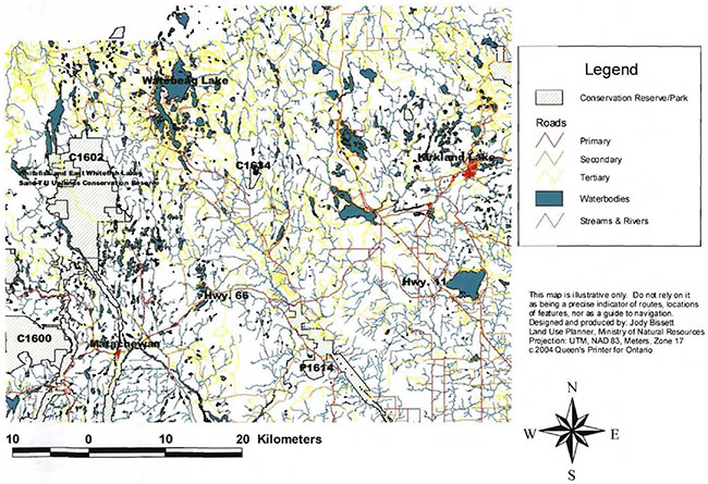
Enlarge Locator map: Whitefish and East Whitefish Lakes Sandy Till Uplands Conservation Reserve
Appendix 8: Natural Heritage - Life science checksheet
- Name: C1602 Whitefish and East Whitefish Lakes Sandy Till Upland Conservation Reserve
- Map Name: Raddisson Lake
- Map Number:: 42A/2
- UTM reference:: 522533
- Locality: Timiskaming
- Latitude: 48°07’ 10"N
- Longitude: 80°42’10" W
- NAD: 83 CNT
- Minimum Altitude: 310 m
- Maximum Altitude: 460 m
- Township: Michie. Robertson, Sheba, Baden, Alma
- Area: 10,320 ha
- Ownership: Crown
- MNR Region: Northeast
- MNR District: Kirkland Lake (jurisdiction)/Timmins
- Ecoregion and Ecodistrict: 3E-5 (Hills 1959& Crins & Uhlig 2000)
- Landform Unit(s) (preliminary): 9 Organic deposits
5 Glaciofluvial Outwash deposits
4 Ice-contact Stratified Drift deposits
2a Bedrock-Drift complex- predominantly till drift cover
2 Bedrock-Drift complex - unsubdivided - Aerial Photographs:
Year-Flight Line-Roll Numbers
94-4807-29-125 to 128
94-4806-29-77 to 81
86-4805-02-154 to 158
94-4804-29-22
86-4804-02-215 to 218
86-4803-04-81 to 82
86-4802-04-17 to 18
Map: C1602 Whitefish and East Whitefish Lakes Sandy Till Upland CR, Natural heritage area - Life science checksheet
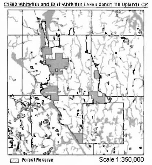
Physical and biological features
Representation
Whitefish and East Whitefish Lakes Sandy Till Upland Conservation Reserve (C1602) is located approximately 35 kilometres west of the town of Kirkland Lake in the townships of Michie, Robertson, Baden, Alma and Sheba. It is over 10,000 hectares in size, is comprised of vectored, biological and cultural boundaries and is linked to the West Montreal River Provincial Park at the southwest corner. Access is gained by means of several harvest roads. The OLL Land Use Strategy (1999) states the site is represented by moderately broken outwash uplands of lacustrine fine sand dominated by moderate to old growth black spruce and all age classes of aspen. Also present is old growth tamarack. The second dominant landform. moderately broken shallow sandy till uplands of lacustrine fine sand and clay, contains black spruce, white birch. jack pine and aspen stands with some old growth yellow birch and tamarack. It will be shown the site contains a slightly different interpretation. both in landforms and in vegetation.
The conservation reserve is located in ecodistrict 3E-5 (Foleyet) of the ecoregion 3E (Lake Abitibi). The ecodistrict is characterized by gently rolling plains with thinly covered rock knobs, sandy outwash and silty depressions. Materials are generally granitic, locally overlain by low-base and low-lime materials. Deep deposits cover 25% of the area and the remaining areas have very shallow deposits (Keddy 1997). With the close association with ecoregion 4E and the Great Lakes-St. Lawrence forest, some sporadic occurrences of species having southern affinities, such as yellow birch, sugar maple and white pine, are present. The ecoregion, also called the Central Boreal Forest Region, is characterized by flat to gently rolling, glacial clay and sandplain with locally extensive peatlands and wetlands, broken throughout by glacial features such as moraines, eskers with Canadian Shield exposure. Regional vegetation includes spruce, poplar, and birch on fresh sites on moderately sloping terrain, white and red pine on sand ridges and American elm and white cedar in protected areas. The forest climate type is mid-humid, mid-boreal (Poser 1992; Noble 1983).
According to the quaternary geology of Ontario coverage (Map 1b), the conservation reserve (CR) is dominated by bedrock with some glaciofluvial ice-contact deposits along Matachewan and Robertson Lakes and northward and some glaciofluvial outwash deposits north of the Matachewan Indian Reserve boundary. This is similar to the NOEGTS (Northern Ontario Engineering Geology Terrain Study) (Lee 1979) map but with a slightly different interpretation. The area is dominated by till (ground moraine) veneer over bedrock with high local relief. A sandy, gravely esker complex exists on the west side, sandy outwash plain north of the native reserve boundary and some sandy glaciolacustrine deposits on the east side. In conversation with Rik Kristjansson (2004), OLL geologist, his interpretation of the CR is similar to the NOEGTS coverage. The site is dominated by bedrock-drift complex (unit 2 and unit 2a). Ice-contact stratified drift deposits (unit 4 and 4a) are dominant on the west side with some possibility of glaciofluvial outwash deposits (unit 5). The finger projections of outwash plain (equivalent to units 5 and Sa) on the NOEGTS map can be extended further north into the CR. Sand dunes may be present (unit 7) within this landform. Organic deposits (unit 9) are scattered throughout the site. Overall bedrock is the controlling feature on this CR.
The area is in Rowe’s (1972) B.7 section (Missinaibi-Cabonga) of the Boreal Forest Region. This section is along the height of land in central Ontario and the bulk of the forest is boreal but also contains within as scattered individuals or isolated patches species from the Great Lakes-St. Lawrence Forest. The predominant forest is mixed consisting of balsam fir, black spruce and white birch with scattered white spruce and trembling aspen. Jack pine occurs on sand terraces and can also be associated with black spruce on poor, rocky soils. Black spruce with tamarack covers wet organic soils and with cedar in other lowlands. The topography is rolling with numerous flats along the rivers and lake sides.
The conservation reserve is dominated by Bw mixedwood
Forest communities were classified into Standard Forest Units (SFU’s), a more ecological approach to forestry. There are 10 different SFU’s of which four accounted for less than 1% of the total area (Map 2d, Appendix 2). The CR was dominated by BW1 (birch poplar) (23.5% of the total area), MW2 (black spruce/aspen mix) (21.7%) and SB1 (black spruce lowland) (21.0%). BW1 and MW2 incorporated much of the white birch and black spruce mixedwoods. MW2 was more concentrated in the north half while BW1 was common in the south half. SB1 was generally associated with lowlands/creek systems. Others, including SP1 (black spruce/jack pine), PO1 (aspen), SF1 (spruce/fir/cedar), accounted each for <10% of the total area.
Wetlands
The conservation reserve is located in the 4MB and 4MD tertiary watersheds of the Moose River major basin in portions of the north half and the 2JD tertiary watershed of the Ottawa River major basin (OMNR 2002). In the latter tertiary watershed, all waters flow in the south direction. It consists of numerous headwater lakes and creeks to the Matachewan Lake/Montreal River system. Northern pike and walleye are found in many of the lakes in the area with lake trout in Currie and Radisson Lakes (Map 3a).
There is an abundance of early wintering area for moose (Map 3a). The forest communities are typical of early winter habitat; mature to overmature mixedwood stands. Late wintering habitat occurs in several areas and these areas are generally dense conifer forest communities. East Whitefish River along the west boundary has suitable moose aquatic feeding areas as well as several other small lakes and creeks along the east and west boundaries.
Other values (Map 3a) include traplines KL027, KL028 and TI09 and bear management areas KL-29-030, and Tl-29-013. A provincially significant native cultural site also exists within the CR (OMNR 1973). Snag habitat is plentiful as a result of declining white birch.
Condition
Condition
Other disturbances were human related. A road/trail passes through the site. Up to an unnamed lake along the Robertson/Baden Township line, a pick-up can be used from the south. Beyond that point, access is only by ATV as far as Radisson Lake. At the road transition, a hunting camp was observed in use during the aerial reconnaissance survey. Another disturbance was in the Robertson and Matachewan Lakes area. Past mining activity has occurred as is evidenced by a soil grubbed to the fault line in a straight line. North of this area, harvesting has occurred in 1997. Most of the block was clear-cut for jack pine and aspen with white birch left standing. The area was artificially regenerated with jack pine. The other harvest (selective) occurred in 1998 just southeast of Radisson Lake for black spruce. The harvest block was left to regenerate naturally resulting in a mixed forest (Burkhardt 2003).
Diversity
Diversity is a measure of the site’s life and earth science heterogeneity. It is based on the number and range (variety) of the natural landscape features and landforms for earth science values and the relative richness and evenness of the site’s life science components. Richness refers to the number of cover types or vegetative cover types. For this CR, diversity
Based on the interpretation of landforms by Kristjansson and SFUs it is estimated there are between 25 to 35 L:V combinations. Wetlands were not considered. The site is dominated by BW1, MW2 on unit 2a and SB1 on unit 2. Once interpreted aerial photos are available a complete analysis can be conducted.
Several other features may alter the diversity rating for the CR. Wetlands account for 9.3% of the total area. Meadow marsh, shore fens and/or poor fens were typical along creeks and floating mats could be found on shallow lakes. Semitreed and treed bogs were found north of Matachewan Indian Reserve in the lower depressions in an area consisting of sand dunes and other sand deposits. Forest community age development stage is another consideration with respect to the diversity rating. Most of the SFUs are represented by all stages of development; immature, mature and old except for SF1, PJ1, MW1 and LC1 which were represented by two stages. The amount of immature BW1 (pure white birch) and SB1 (pure black spruce) may be misleading since most of these stands were classified as barren-and scattered and have no age assigned to them. In most likelihood, they are mostly represented by mature and old growth forest communities. Dispersion reduces the diversity rating. MW2 is concentrated in the north half and BW1 is concentrated in the south half with SB1 more apparent in the middle of the CR. The other SFUs, although less dominant, are scattered throughout the site.
Evenness
Ecological considerations
Whenever possible, a site’s boundaries should be created to include the greatest diversity of life and earth science features to provide maximum ecological integrity. It should be ecologically self-contained, bounded by natural features and include adequate area to buffer the core ecosystems from intrusive influences (OMNR 1992). The overall design of the CR is fair to good. It is mostly bound by biological features with few vectors. The only possible change that could be made is to remove vectors (see Appendix 1 -Ecological Considerations) at Radisson Lake. The creeks east of this lake could have been used instead. The projection into Michie Township should be removed since it provides little benefit to the core habitat. The other projection, between Radisson and Currie Lakes, has ample water area to protect from any intrusive forces. An important design aspect of this CR is the linkage to the Montreal River Provincial Park and ultimately to C1600 south of the CR. It increases representation in a protected area and thus diversity.
Currently we do not have minimum size standards for conservation reserves under different landscape conditions. However, a minimum size standard of 2000 ha has been established for natural environment parks by Ontario Parks (OMNR 1992). This minimum standard was considered necessary to protect representative landscapes as well as allow for low intensity recreational activities. Large sites are preferred over small sites as it has greater potential for ecological diversity and stability. This CR fulfils beyond the minimum standard. Along with the many biological boundaries, most of the core areas remained intact and it has good abilities to buffer adjacent influences.
Special features
Special features of the CR include:
- sand dunes, although not as distinct as those in C1596, north of the Native Reserve
- Matachewan Lake with bedrock outcrops, very steep slopes and the red pine and understory of cedar along the edge
- the bedrock knob ridge in the near middle of the site with white birch forest communities (birch, maples, some pine) and trembling aspen mixed and supercanopy white pine on the slopes
- the bedrock point, with some cliff faces, between Radisson and Currie Lakes
- the rolling topography from bedrock knobs to black spruce lowlands
Major information sources
Arnup, R., G.D. Racey and R.E. Whaley. 1999. Training manual for photo interpretation of ecosites in northwestern Ontario. NWST Technical Manual TM-003.127 p.
Bridge, Simon; Watt, Robert; Lucking, Greg; and Brian Naylor. 2000. Landscape analysis for forest management planning in boreal northeastern Ontario. OMNR, Northeast Science & Technology. 36 p.
Burkhardt, B.C. 2003. C1602 Aerial Reconnaissance Notes.
Crins, W.J. and P. W. C. Uhlig. 2000. Ecoregions of Ontario: Modifications to Angus Hills’ Site Regions and Site Districts - Revisions and Rationale.
Harris, A.G., S.C. McMurray, P.W.C. Uhlig, J.K. Jeglum, R.F. Foster and G.D. Racey. 1996. Field guide to the wetland ecosystem classification for northwestern Ontario. Ont. Min. Natur. Resour., Northwest Sci. & Technol. Thunder Bay, Ont. Field Guide FG-01. 74 pp. + append.
Hills, G.A. 1959. A Ready Reference to the Description of the Land of Ontario and its Productivity.
Keddie, C. 1997. Natural Heritage Gap Analysis for Site District 3E-5: GIS Analysis. by Geomatics International Inc.
Kristjansson, R. 2004. Personal Conversation.
Lee, Hulbert A 1979. Northern Ontario Engineering Geology Terrain Study, Data Base Map, Kirkland Lake. Ontario Geological Survey, Map 5030, Scale 1:100 000.
Noble, T.W. 1983. Central Boreal Forest Region (3E). Life Science Report. Northeastern Region. Internal report.
Ontario Ministry of Natural Resources. 2002. MNR Districts and Major Basins of Ontario.
Ontario Ministry of Natural Resources. 1999. Ontario Living Legacy Land Use Strategy.
Ontario Ministry of Natural Resources. 1992. Ontario Provincial Parks: Planning and Management Policies -1992 Update.
Ontario Parks. 2003. Landform Vegetation Representation Summary for site C1602 in Ecodistrict 3E-5. (May 2003). Internal Report
Ontario Ministry of Natural Resources. 1973. Strategic Sensitive Areas. Internal Publication
Rowe, J.S. 1972. Forest Regions of Canada. Department of Fisheries and the Environment-Canadian Forestry Service Publication No. 1300. 172p.
Taylor, K.C., R.W. Arnup, B.G. Merchant, W.J. Parton and J. Nieppola. 2000. A field guide to forest ecosystems of Northeastern Ontario. 2nd Edition. Northeast Science and Technology NEST Field Guide FG-001.
Thompson, John E. & Jake Noordhof. 2003. Edit Model for N.E. Region Life Science Checksheets. Internal Report.
Significance level (provincial/regional/local) and Brief summary of major representative values
The original site was a gap site determined through a gap analysis conducted by Geomatics International Inc. (Keddie 1997) but with a different configuration. It went from Whitefish Lake in the west and around the east side of the Matachewan Indian Reserve at 10,835 hectares. It was considered provincially significant in that it contained 7 landform:vegetation units that were only represented in the site within the whole ecodistrict. Some of these units included old yellow birch on moderately broken sandy till uplands, old growth tamarack on moderately broken outwash uplands and immature white spruce on moderately broken outwash uplands. The OLL Land Use Strategy (1999) description is based on this gap analysis.
Since the gap analysis the CR has been reconfigured and the regulated boundary has not changed significantly from this blue line site (see Appendix 1 - History). The new significance is unknown. The analysis conducted by Ontario Parks (2003) indicates there are no landform:vegetation units that are provincially significant. All units are represented elsewhere in the ecodistrict. The dominant units are mixed deciduous forests and mixed coniferous forests on bedrock. This would be equivalent to BW1, MW2 and SB1 in our interpretation. Bedrock is the dominant landform in the CR but as a complex with till (landform unit 2 and unit 2a) and is the controlling feature of the site. According to Rik Kristjansson, there are more glaciofluvial outwash deposits (unit 5) and ice-contact stratified drift deposits (unit 4) in the site than indicated by Ontario Parks.
Sensitivity
Due to the large areas of old growth and the high degree of white birch decline, the area is susceptible to forest fires. Fire has not played a significant role in this area for many decades (see Appendix 1 - C1602 Fire Disturbance). Prescribed burning will perhaps increase the amount of red and white pine in the site.
Recommendations
- This second step checksheet should be advanced to a fourth step by digitizing the earth science data based on Kristjansson’s interpretations of aerial photos, once these become available and used with SFU to complete a current landform:vegetation analysis. Finally, the checksheet could be advanced to a fifth step by comparing the fourth step checksheet with the current provincial landform layers based on the new regulated boundary to see if comparisons can be made. In turn we can determine more fully the site’s significance and contribution to the parks and protected areas program.
- The vectored boundaries for the site should be marked to ensure that the values within the site are protected from surrounding land use activities. Further analysis and assessment may require additional management prescription to ensure long term protection of the site’s natural heritage values.
- Removing Whitefish Lake from the conservation reserve name as it is no longer part of site.
- Alter some of the vectored boundaries to create more ecological boundaries as indicated in the Ecological Considerations map (Appendix 1) and to reduce the risk of any trespassing. If areas are lost due to OPA/PPL disentanglement, the suggested replacement area would be west of the CR as it is the only area adjacent to the site that has not been recently harvested and is still within the Timiskaming Forest SFL. Most areas east of the CR have been harvested in the past 10 years.
- Funding should be secured in the near future to determine the number and location of roads and trails currently present within the site using current global positioning technologies.
- Any future trail development must consider the values found within the boundaries of the site, the rationale for developing trails within the site and the availability of current access through the site and surrounding areas. Furthermore, any new trail development will require a ‘Test of Compatibility’. Low-lying areas and wetlands should be avoided.
- Overall custodial management is the responsibility of the district office with support from the regional natural heritage specialist and Ontario Parks. To advance conservation reserve custodial management, future managers will need to monitor the current state of the CRs resources at least at the community and landscape levels within and adjacent to the conservation reserve and its surrounding environment. Such monitoring could include: evaluating and reporting on changes such as; natural disturbances (i.e. fire, insect/disease, wind throw, etc.), human disturbances (i.e. forest harvesting, access and/or other land use activities) as well as management prescriptions (i.e. rehabilitation efforts and/or vegetative management planning).
- Ongoing evaluations and reports will have to rely on current and new technologies such as satellite imagery, global positioning systems (GPS), supplementary aerial photography (SAP) and/or aerial/ground reconnaissance surveys/assessments conducted periodically and placed within a GIS database. Such tools could help managers spatially record areas affected severity of perturbations or management action as well as consider the sensitivity of values, the design of CR and determine the future desired condition of the site. Monitoring efficiencies could be enhanced via partnerships and internal coordination within MNR.
footnote 9
Time Effort Spent on Site
September 23, 2003 1:40 to 3:00
Date Compiled
March 20, 2004
Compiler(s)
Barbara Burkhardt, Lori King, Sean Longyear
Date Reviewed
Reviewer
Photos
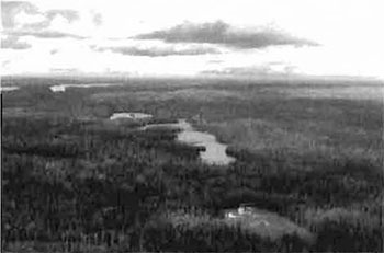
Taken from south side of East Whitefish Lakes, northwards. Float mats in small waterbody and shore fens on lake. Surrounded by Bw pure & Bw mixedwoods. Bw declining.
Photo 27_3. Taken by B. Burkhardt, Sept. 23/03
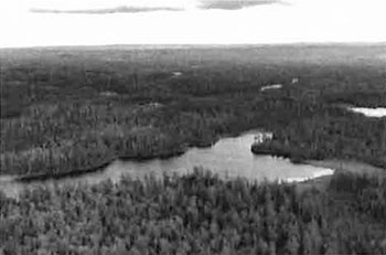
South of Currie Lake, along the west boundary, looking SE. Meadow marsh & poor fens along shoreline. Some supercanopy Pw present. Forest communities include Bw mixedwood, Pj predominant conifer & Sb conifer mixed.
Photo 27 15. Taken by B Burkhardt. Sept.23/03
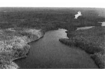
North end of Matachewan Lake, looking south. East side of lake consists of Bw/Sw true mixed, Bw pure, Bw mixedwood & Bw hardwood mixed. Some Pr with Ce understory on edge.
Photo 27_20. Taken by B. Burkhardt, Sept. 23/03
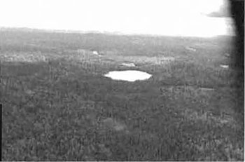
Taken at the top mid-north boundary, south. Sb pure (treed bog/conifer swamp) in lowlands with some treed bog. Surrounded by Sb conifer mixed & Bw mixedwood.
Photo 27 8. Taken by B. Burkhardt. Sept. 23/03
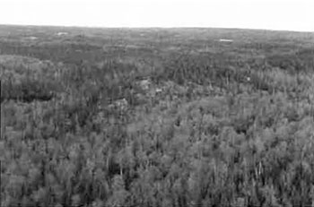
Bedrock knob, west of north end of Robb Lake. Bw mixedwood on bedrock & Bw pure (includes maples) with Pw supercanopy.
Photo 27_19. Taken by B. Burkhardt, Sept. 23/03
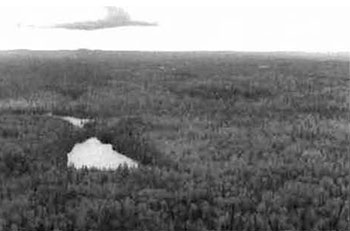
Taken from the NW corner of Matachewan Indian Reserve, looking west towards bedrock ridge in middle of CR. Forest primarily Bw mixedwood, Bw hardwood mixed, Bw pure & Sb mixedwood.
Photo 27 24. Taken by B. Burkhardt Sept. 23/03
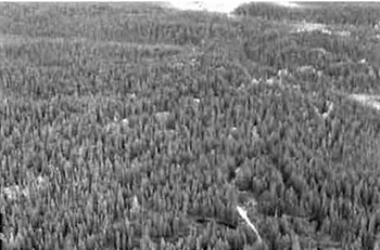
Taken off the NW corner of the Matachewan Indian Reserve. looking NE. Some examples of sand dunes (although not as good as C1600) with Pj surrounded by Sb dominant conifer & Sb pure (treed bog/conifer swamp) and some semi-treed bog.
Photo 28_1. Taken by B. Burkhardt, Sept. 23/03
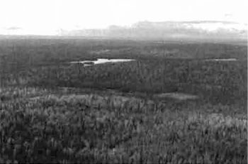
Taken from the east boundary, looking NW towards north part of the CR. Mix of Bw/Sb true mixed, Sb pure (treed bog/conifer swamp)& Bw mixedwood. Shore and poor fens on small lake in foreground.
Photo 28_6. Taken by B. Burkhardt, Sept. 23/03
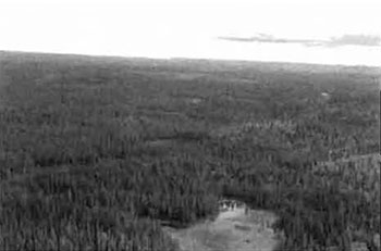
Taken at the center of the CR, looking south. Float mats in waterbody. Surrounded by Sb pure (treed bog/conifer swamp) & Bw mixedwood.
Photo 28_2. Taken by B. Burkhardt, Sept. 23/03
Map 1b: C1602 Whitefish and East Whitefish Lakes Sandy Till Upland CR, Geology
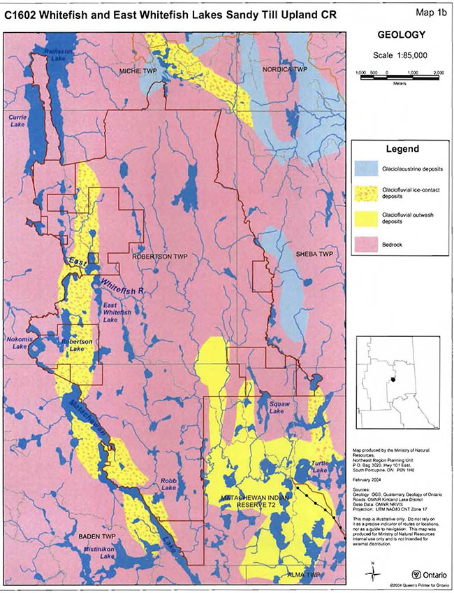
Enlarge Map 1: C1602 Whitefish and East Whitefish Lakes Sandy Till Upland CR, Geology
Map 2a: C1602 Whitefish and East Whitefish Lakes Sandy Till Upland CR, Forest Communities
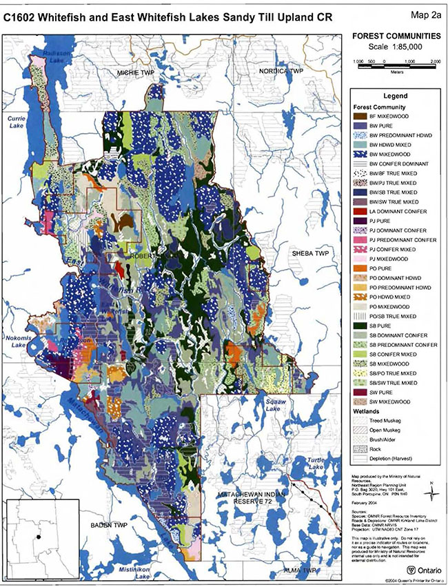
Enlarge Map 2a: C1602 Whitefish and East Whitefish Lakes Sandy Till Upland CR, Forest Communities
Map 2b: C1602 Whitefish and East Whitefish Lakes Sandy Till Upland CR, Stocking Distribution

Enlarge Map 2b: C1602 Whitefish and East Whitefish Lakes Sandy Till Upland CR, Stocking Distribution
Map 2c: C1602 Whitefish and East Whitefish Lakes Sandy Till Upland CR, Age Distribution
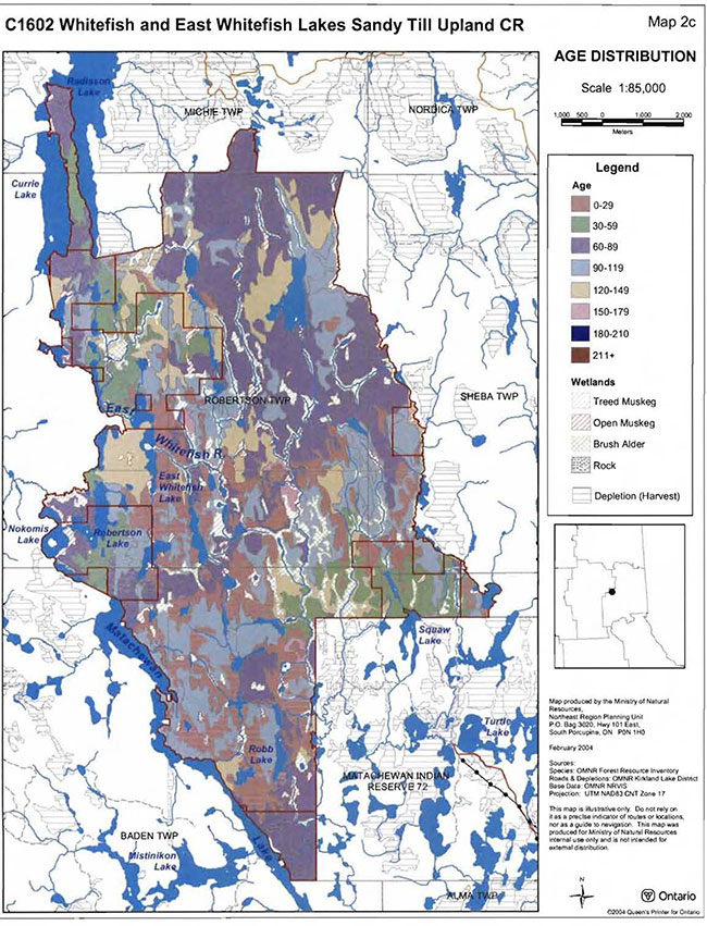
Enlarge Map 2c: C1602 Whitefish and East Whitefish Lakes Sandy Till Upland CR, Age Distribution
Map 2d: C1602 Whitefish and East Whitefish Lakes Sandy Till Upland CR, Standard Forest Units
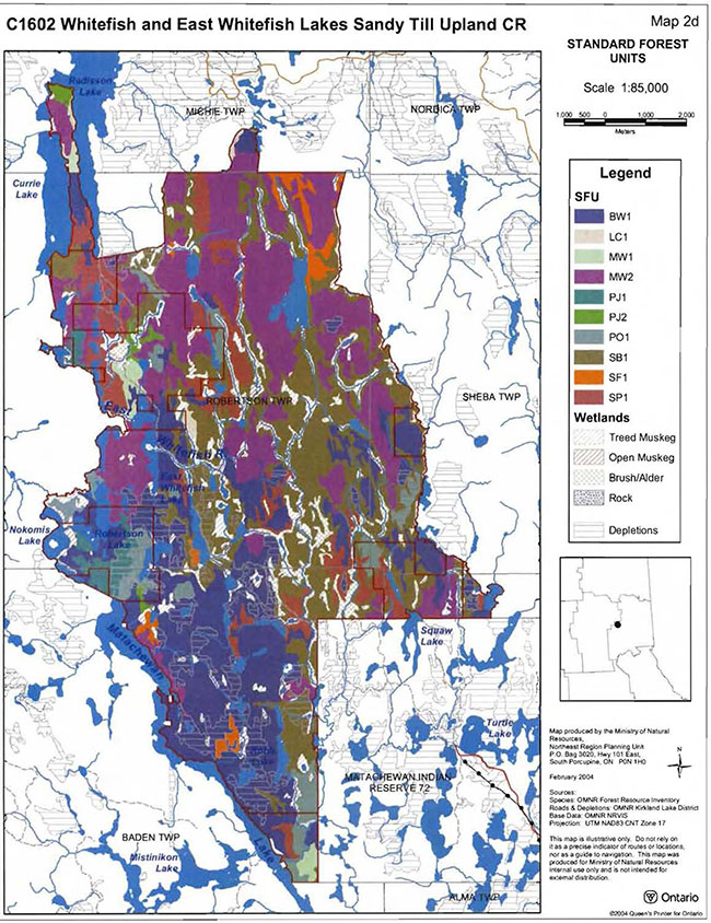
Enlarge Map 2d: C1602 Whitefish and East Whitefish Lakes Sandy Till Upland CR, Standard Forest Units
Map 3a: C1602 Whitefish and East Whitefish Lakes Sandy Till Upland CR, Values

Enlarge Map 3a: C1602 Whitefish and East Whitefish Lakes Sandy Till Upland CR, Values
Map 3b: C1602 Whitefish and East Whitefish Lakes Sandy Till Upland CR, Wetlands
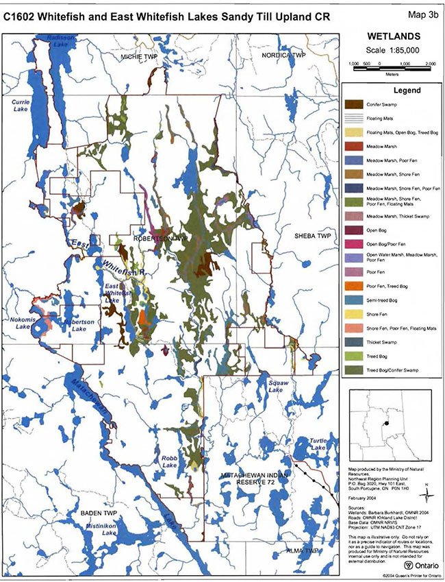
Enlarge Map 3b: C1602 Whitefish and East Whitefish Lakes Sandy Till Upland CR, Wetlands
Map 4: C1602 Whitefish and East Whitefish Lakes Sandy Till Upland CR, Data Gathering map
Enlarge Map 4: C1602 Whitefish and East Whitefish Lakes Sandy Till Upland CR, Data Gathering
Map 5: C1602 Whitefish and East Whitefish Lakes Sandy Till Upland CR, Old Growth map
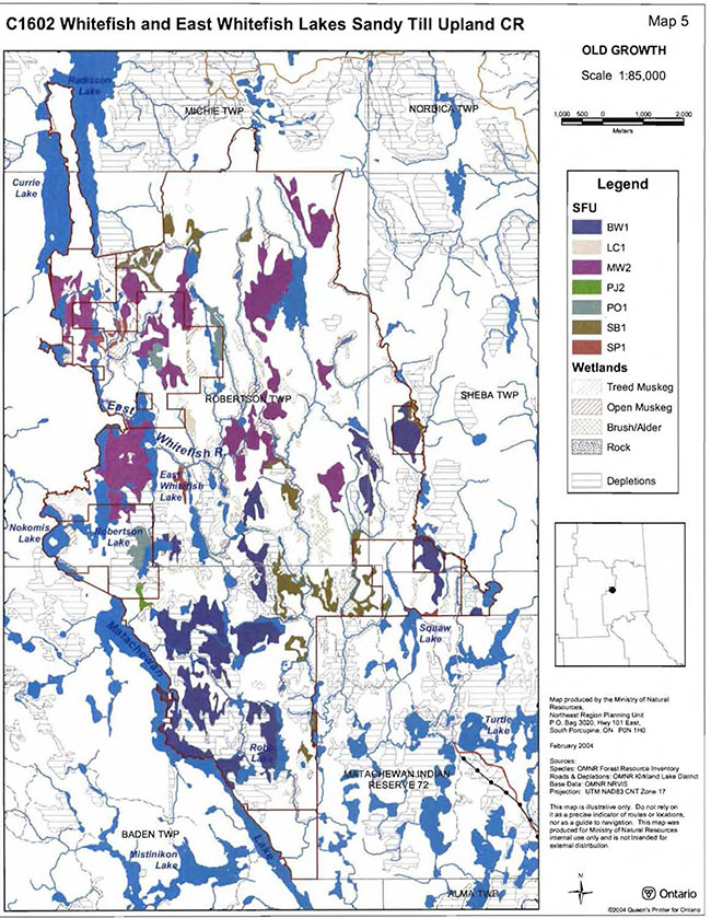
Enlarge Map 5: C1602 Whitefish and East Whitefish Lakes Sandy Till Upland CR, Old Growth
C1602 Whitefish and East Whitefish Lakes Sandy Till Upland CR, Ecological Consideration map
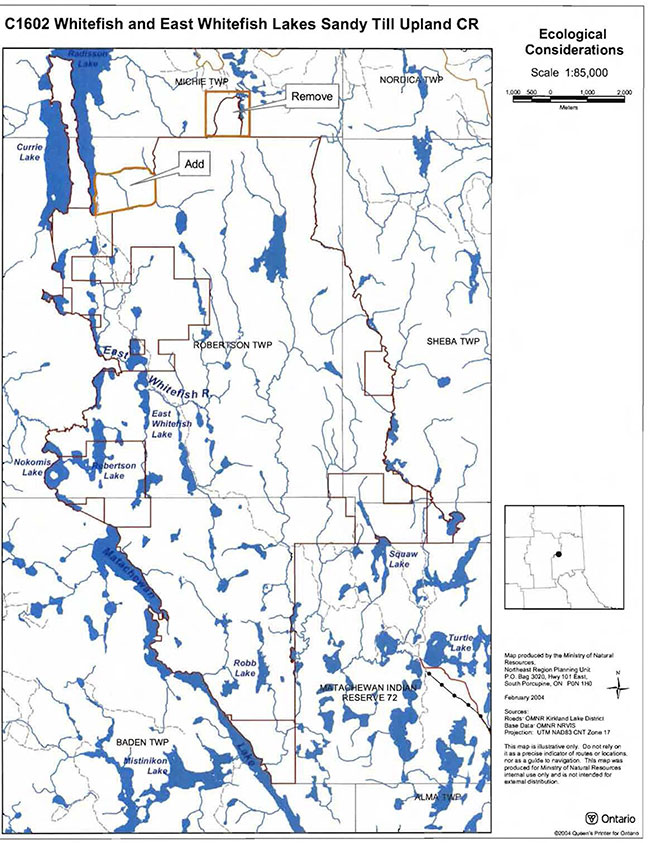
C1602 Whitefish and East Whitefish Lakes Sandy Till Upland CR, Fire Disturbance Map
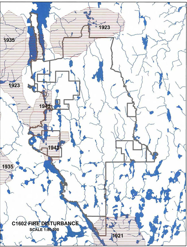
Enlarge Map 6: C1602 Whitefish and East Whitefish Lakes Sandy Till Upland CR, Fire Disturbance Map
C1602 Whitefish and East Whitefish Lakes Sandy Till Upland CR, History map
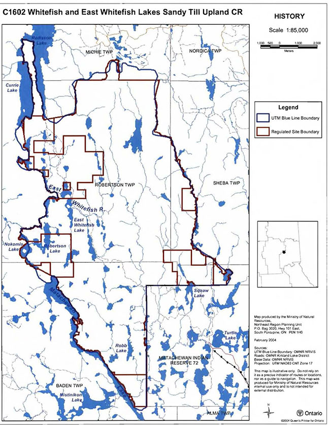
Enlarge Map 7: C1602 Whitefish and East Whitefish Lakes Sandy Till Upland CR, History
Appendix 9: Earth science checksheet
N/A
Appendix 10: Regulation maps
Plan of Whitefish and East Whitefish Lakes Sandy Till Upland Conservation Reserve. Sheet 1 of 2
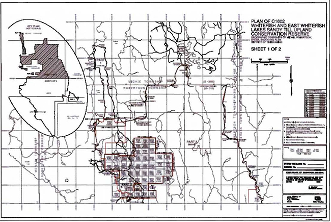
Plan of Whitefish and East Whitefish Lakes Sandy Till Upland Conservation Reserve. Sheet 2 of 2
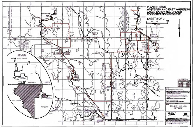
Appendix 11: James Bay Treaty - Treaty #9
The James Bay Treaty - Treaty No. 9
Appendix 12: Robinson Treaty
Cat. No. Robinson Treaty. Ci 72-1264
Footnotes
- footnote[1] Back to paragraph Mixedwoods are defined as follows: hardwood mixedwoods are stands dominated by hardwoods with less than 30% cover of conifer in the main canopy; similarly conifer mixedwoods contain less than 30% hardwoods in the canopy. Mixedwoods contain approximately equal percentages of conifer and hardwood trees and true mixedwoods contain a 50:50 split between conifers and hardwoods (modified after Taylor et al 2000).
- footnote[2] Back to paragraph Diversity rating, developed by John Thompson & Jake Noordhof (2003), is based on the size of the conservation reserve versus the number of landforms:vegetation (SFU/HU) combinations. For CRs < 500 ha, high diversity is >25 L:V combinations, medium for >15 L:V, and low for < 15 L:V. For areas 500 - 2000 ha, high is >30, medium >20 and low <20. For areas >2000 ha, high >35, medium >25 and low <25 L:V combinations
- footnote[3] Back to paragraph Mixedwoods are defined as follows: hardwood mixedwoods are stands dominated by hardwoods with less than 30% cover of conifer in the main canopy; similarly conifer mixedwoods contain less than 30% hardwoods in the canopy. Mixedwoods contain approximately equal percentages of conifer and hardwood trees and true mixedwoods contain a 50:50 split between conifers and hardwoods (modified after Taylor et al 2000).
- footnote[4] Back to paragraph Conifer stands are defined as follows: pure conifer stands contain 100% of a conifer trees in the canopy; dominant conifer stands contain less than 10% cover of hardwoods in the main canopy and predominant conifer stands contain less than 20% cover of hardwoods in the main canopy. Similarly hardwood stands may contain no conifer in canopy (pure hardwood), less than 10% conifer (dominant hardwood) or less than 20% conifer cover (predominant hardwood) (modified after Taylor et al 2000).
- footnote[5] Back to paragraph Wetlands were classified after Arnup et al. 1999 and Harris et al. 1996.
- footnote[6] Back to paragraph Rating based on the amount of area currently under some form of known disturbance. High is >20% of the area, medium 10 to 20%, low < 10% and pristine < 1%.
- footnote[7] Back to paragraph Diversity rating, developed by John Thompson & Jake Noordhof (2003), is based on the size of the conservation reserve versus the number of landforms:vegetation (SFU/HU) combinations. For CRs < 500 ha, high diversity is > 25 L:V combinations, medium for >15 L:V, and low for < 15 L:V. For areas 500- 2000 ha, high is >30, medium >20 and low < 20. For areas >2000 ha, high >35, medium >25 and low < 25 L:V combinations.
- footnote[8] Back to paragraph Evenness of the site defined as strongly skewed (top 3 communities capture >=60% of the site in area), moderately skewed (30-59%) or slightly skewed to even (< 30%).
- footnote[9] Back to paragraph Coordination could include a variety of expertise from the following: Field Services Division, Ontario Parks, Aviation and Forest Fire Management Branch, Forest Health and Silvicultural and Forest Management Planning Sections, Northeast Science and Information etc. Additional expertise within and outside the MNR could be sought as required.