Boyne Valley Provincial Park Management Statement: Amendment
This amendment provides revised direction in the statement to restore or naturalize disturbed lands, including lands previously used for agriculture, in order to enhance ecological integrity.
Examination and adjustment of management direction
| Approval Date | Examination or Type of Adjustment | Examination Outcome (where applicable) | Comment |
|---|---|---|---|
| January 20, 1995 | Management Plan | N/A | Regional Director’s Approval Statement signed by Gail Beggs |
| May 27, 2004 | Terms of Reference | N/A | Planning underway to develop a new management plan |
| March 22, 2011 | Examination | Re-write | Examination complete per PPCRA requirement; existing Management Direction extended for 10 years pending rewrite. |
| February 24, 2016 | Administrative Update | N/A | Update existing Management Direction to reflect current legislation and policy |
| May 4, 2016 | Amendment | N/A | Amend existing management direction to enable restoration. |
Amendment approval statement
Dear Sir or Madam:
I am pleased to approve this amendment to the management plan for Boyne Valley Provincial Park. The amendment provides revised direction in the plan to restore or naturalize disturbed lands, including lands previously used for agriculture, in order to enhance ecological integrity.
I would like to express my appreciation to all those who participated in the planning process.
Sincerely,
Signed by Bruce Bateman
Director, Ontario Parks
Date May 2, 2017
Regional director’s approval statement
January 20, 1995
This Interim Management Statement will provide interim direction for the management of Boyne Valley Provincial Park until a comprehensive Park Management Plan has been prepared.
This statement will provide the basis for future preparation of the Park Management Plan. I am pleased to approve this Interim Management Statement for Boyne Valley Provincial Park.
Background Information
Name: Boyne Valley Provincial Park
Proposed Class: Natural Environment
MNRF Parks Zone: Southwest
MNRF Region: Southern Region
Total Area (ha): 431
Ecodistrict: 6E-7
Date in Regulation: Reg. 279/85
Targets
1. Life science representation
| Site Type / Landscape Unit | Feature |
|---|---|
| Bottomland wetlands (organic substrates) (focus of Boyne Valley Life Science Area of Natural and Scientific Interest (ANSI)) | Conifer & mixed swamp, beaver ponds, minor meadow marshes, major braided stream system. |
| Mesic North facing flops and ravines (focus of Boyne Valley Life Science ANSI) | Mixed forest, seepages zones/springs, streams. |
| Dry South facing slopes and ravines (focus of Boyne Valley Life Science ANSI) | Deciduous forest. |
| Limestone canyons/cliffs (focus of Boyne Valley Life Science ANSI) | Moist talus rubble, stream thicket and cliff communities. |
| Tableland and bottomland fields (focus of Boyne Valley Life Science ANSI) | Agricultural crops & pastures, old field succession, hawthorn thickets, pine plantations. |
2. Earth science representation
| Geologic Theme | Feature |
|---|---|
| Paleozoic (Niagara Escarpment) Silurian (Cataract Group) | Exposures as narrow canyon in SW corner of park and cliffs where Rd. 16 crosses Boyne River |
| Paleozoic (Niagara Escarpment) Ordovician (Queenston Formation) | Underlying bedrock to the east. |
| Pleistocene (Primrose-Boyne Valley Earth Science ANSI) | Major river valley occupying provincially significant Violet Hill Spillway. |
| Pleistocene (Primrose-Boyne Valley Earth Science ANSI) | Associated, terraced meltwater channel at SE edge (440-445m ASL) |
| Pleistocene (Primrose-Boyne Valley Earth Science ANSI) | Orangeville Morraine forms the southcentral and northcentral tablelands, with prominent heights of land (505m ASL) |
| Pleistocene (Primrose-Boyne Valley Earth Science ANSI) | Rough, boulder meltwater terrain in western portion of the valley. |
| Holocene | Broad, bottomland organic deposits and braided, beaver-ponded streams in Boyne Valley (390-410m ASL) |
3. Cultural resources representation
| Theme | Theme Segment |
|---|---|
| Local significance only | Effects of escarpment on settlement pattern |
4. Recreational opportunities
| Day Use | Car Camping | Wilderness/ Backcountry |
|---|---|---|
| Hiking, nature appreciation, fishing, hunting (on non-regulated Crown land) | Nil | Nil |
Inventories
| Inventory Type | Earth Science | Life Science | Cultural | Recreational | Other |
|---|---|---|---|---|---|
| Reconnaissance completion date | N/A | 1987 | N/A | N/A | N/A |
| Detailed completion date | 1991 | N/A | 1971, 1973 | N/A | N/A |
| Required? | N/A | Detailed | N/A | N/A | N/A |
Figure 1: Regional setting map
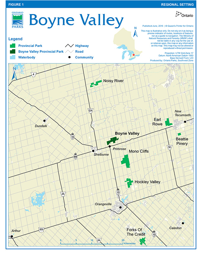
Enlarge figure 1: Regional setting map
Figure 2: Park boundary and existing development map
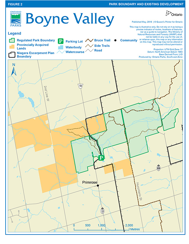
Enlarge figure 2: Park boundary and existing development map
Context
1. Provincial Parks and Conservation Reserves Act
The Provincial Parks and Conservation Reserves Act, 2006 (PPCRA) requires that a Management Direction is approved for each protected area in Ontario. This document fulfils this requirement, and provides direction for managing the provincial park.
The PPCRA has two principles that guide all aspects of planning and management of Ontario’s system of provincial parks and conservation reserves:
- Maintenance of ecological integrity shall be the first priority and the restoration of ecological integrity shall be considered.
- Opportunities for consultation shall be provided. 2006, c. 12, s. 3.
The PPCRA also outlines four objectives for establishing and managing provincial parks:
- To permanently protect representative ecosystems, biodiversity and provincially significant elements of Ontario’s natural and cultural heritage and to manage these areas to ensure that ecological integrity is maintained.
- To provide opportunities for ecologically sustainable recreation opportunities and encourage associated economic benefits.
- To provide opportunities for residents of Ontario and visitors to increase their knowledge and appreciation of Ontario’s natural and cultural heritage.
- To facilitate scientific research and to provide points of reference to support monitoring of ecological change on the broader landscape. 2006, c. 12, s. 2 (1).
2. Management context
Management of this park will be consistent with all relevant legislation and provincial policies, including the four provincial park objectives and guiding principles of the PPCRA. Management of the park will also be consistent with the Endangered Species Act, 2007 (ESA), including the protection of Species at Risk.
The implementation of projects in this provincial park will comply with the requirements of A Class Environmental Assessment for Provincial Parks and Conservation Reserves (Class EA-PPCR). This may include further opportunities for consultation, as required.
Boyne Valley Provincial Park encompasses a portion of the Niagara Escarpment and is therefore within the Niagara Escarpment Plan Area. The park contributes to the Niagara Escarpment Parks and Open Space System (NEPOSS)
Management guidelines
1. Land tenure
The Ministry presently owns over 1,000 hectares of which 431 hectares are regulated under the Provincial Parks and Conservation Reserves Act (Figure 1). The area within park regulation is shown on Figure 2. Several hundred hectares of acquired Crown lands upstream of the regulated park may have potential to be added to the park to protect the Boyne River Valley and the coldwater stream habitat.
Two land use permits, totalling 253 hectares, were issued in 1994 for the purpose of pasture and cash crops. A seasonal recreational (snowmobile) trail land use permit is issued annually to the Dufferin Drift Busters Snowmobile Club.
Guidelines:
Adjacent acquired Crown lands will be considered for possible inclusion in the provincial park or may be declared surplus and disposed of.
Agricultural land use permits have been phased out in accordance with park policy. The seasonal recreational (snowmobile) trail land use permit may be renewed on an annual basis.
2. Land acquisition and disposition
Further land acquisition is proposed for:
- Part of Lot 2, Concession 1, West of Hurontario Street (J. Weir property),
- Part of the Hurontario Street road allowance between Concession 1, East of Hurontario Street, and Concession 1, West of Hurontario Street (through Lots 1 through 4),
- Parts of the road allowance between Concessions 1 and 2, West of Hurontario Street, in Lots 2 and 3, and
- Part of Deviation Road (Instrument No. 12539), West Half of Lot 2, Concession 1, West of Hurontario Street.
Guidelines:
Ontario Parks will support, in principle, the acquisition of property for addition to Boyne Valley Provincial Park, if the acquisition will enhance the values or management of the park. Acquisition or securement will be subject to funding and willingness of the owners to sell or lease their properties or enter into a conservation easement. Land securement priorities for Boyne Valley Provincial Park are focused on lands adjacent and with similar natural and cultural values. Newly acquired lands will be regulated as part of the park.
The status of adjacent acquired Crown land will be reviewed and such lands may either be placed into regulation as part of the park or declared surplus and disposed of through sale or land exchange.
3. Existing development
Existing development on current land holdings include:
- one barn
- one drive shed
- approximately 2 kilometres of the Bruce Trail
- approximately 20 kilometres of snowmobile trail
A small parking area located on the east side of Concession I East of Hurontario Street (EHS) is often used by fisherman to access the stream at this location.
Guideline:
The small parking area adjacent to the road allowance must be monitored for garbage.
4. Proposed development
There are no plans for the development of the provincial park in the next five to ten years. Most of the proposals of the park master plan prepared by M.M. Dillon Limited and D.W. Graham and Associates Limited in 1975 are no longer considered to be relevant in the context of current recreational demands and funding constraints.
The park areas falls entirely within the Niagara Escarpment Planning Area and also within the area which is subject to development control by the Niagara Escarpment Commission.
Guidelines:
Prior to any major development, a park management plan will be prepared with full public consultation.
On an interim basis it would be desirable to establish a public access point with a small parking lot, vault privies and picnic tables. The preferred location is on the east side of Prince of Wales Road on Lot 4, Concession 1 West of Hurontario Street (WHS).
5. Recreation activities
The property is used extensively by hikers, cyclists, cross-country skiers, snowmobilers, trail bike and all-terrain vehicle riders. Some fishing for brook, brown and rainbow trout occurs along the Boyne River. Small game hunting occurs on the adjacent Crown lands.
Some park resources (i.e., historical and life science features) are sensitive to damage. A detailed life science inventory is required to evaluate the appropriate recreational uses of the property.
The Bruce Trail passes through the park. A side trail (Primrose Loop) provides access to an excellent lookout.
The park was used extensively by the City of Toronto Board of Education for outdoor education activities. The board used to operate an outdoor education centre in the northeast corner of the property.
Guidelines:
The Dufferin Hi-Land Bruce Trail Club will continue to maintain the hiking trail through the area.
The Dufferin Drift Busters Snowmobile Club will continue to maintain the snowmobile trail through the area.
In consultation with local trail groups and park users, a study of existing formal and informal trails should be carried out. Subsequently, a trail implementation plan should be prepared which would rationalize the trail network based on a consideration of environmental suitability, public safety, user compatibility, provincial park policy and other available technical resources.
Undesirable trail uses will be prohibited. Signage and enforcement will be applied as required.
6. Natural resource management
The provincial park and adjacent areas contain provincially significant areas of natural and scientific interest (ANSI's), namely the Boyne Valley Life Science ANSI and the Primrose – Boyne Valley Earth Science ANSI.
Land and water management guidelines:
The existing trail system may be modified and improved by completion of a trails assessment and proper marking of the trail system.
Undesirable trail uses may be prohibited by signage and enforcement including, the use of the property by trail bikes and all-terrain-vehicles. Much of the unauthorized use occurs on the existing road allowances that are not included as park property.
Agricultural land use permits have been phased out in accordance with park policy.
Disturbed lands including those currently or formerly in agricultural use will be restored or naturalized. The primary goal of restoration and naturalization will be to enhance the park’s ecological integrity by accelerating succession from disturbed areas such as agriculture or old field to locally representative vegetation types, while minimizing colonization of noxious weeds or alien invasive species. Restoration and naturalization approaches could include passive or indirect restoration, seeding and planting, wetland improvement, progressive retirement and invasive species control. Site specific restoration and naturalization activities will be determined based on current site conditions, available resources, funding and partnership opportunities, and will be subject to evaluation under the Class EA-PPCR.
Surveillance and garbage clean-up should be performed on a regular basis.
Improved signage is required on the property to encourage permitted used and discourage abuse of the property.
Improvements to public access, vault privies and picnic tables will be considered to accommodate existing use if funding is available for development and operation.
Fauna management guidelines
Sport fishing will be allowed to continue.
Commercial trapping will not be permitted within the provincial park. Trapping of nuisance animals will be permitted as a resource management technique.
Hunting will not be permitted within the provincial park.
7. Cultural heritage resource management
Guidelines
Cultural heritage resources that may be impacted by any park projects and activities shall be identified and managed (i.e., protected, maintained, used and disposed of) in accordance with the Standards and Guidelines for Conservation of Provincial Heritage Properties (Ontario Heritage Act). Staff will also consult MNRF's Technical Guideline for Cultural Heritage Resources for Projects Planned Under the Class Environmental Assessment for Resource Stewardship and Facility Development and the Class Environmental Assessment for Provincial Parks and Conservation Reserves (2006).
8. Marketing
Guideline:
Until a management plan is prepared and priorities are set regarding development of the property, no plan has been suggested to promote the park other than general information available through Earl Rowe Provincial Park or the Southwest Parks Zone Office. Marketing for Boyne Valley Provincial Park would also occur through Ontario Parks' corporate marketing strategies and activities.
9. Research
Numerous reports were prepared between 1973 and 1975 during the preparation of the first park management plan.
Reviewing the park management plan and completing an assessment of existing and proposed trail systems are the priority projects for this property.
Research activities require authorization issued under the PPCRA, consistent with research authorization policies for Provincial Parks and Conservation Reserves. Research is subject to development and management policies associated with the park’s classification, unless special permission is given. Research must meet all requirements under applicable provincial and federal legislation, and may require additional permits or approval (e.g., MNRF Wildlife Scientific Collector authorization or ESA permits).
Guidelines:
A detailed life science inventory and evaluation may be completed prior to preparation of a park management plan.
A trail plan may be completed prior to the preparation of a park management plan.
The MNRF will encourage scientific research by qualified individuals contributing to the knowledge of natural and cultural history and to environmental management. Ontario Parks will review proposed research to ensure adequate consideration of potential impacts on protected area resources, features, staff and visitors.
References
Beechey, T.J. and A.G. Tracey. Primrose Provincial Park Reserve: Environmental Planning Series Miscellaneous Report - An Environmental Impact Study. Toronto, Ontario Ministry of Natural Resources, Park Planning Branch, 1973.
Bingham, D.A. Proposed Park at Primrose - A History. Earl Rowe Provincial Park, 1973.
Bishop, Fred. Interpretive Directional Planning for Primrose Provincial Park. Ontario Ministry of Natural Resources, 1973.
Bruce Trail Association. Bruce Trail Reference, 19th Edition. Hamilton, 1994.
Clayton Research Association. Market Analysis. 1973.
Comments on Specific Areas of the Primrose Property. 1971.
Greenland, Gary. Brief Historical Inventory of Primrose Park Reserve. Ontario Ministry of Natural Resources, Historical Sites Branch, Planning: Research, 1973.
Harris, A., R. Ritchie and M. Stabb. A Preliminary Life Science Survey. Mulmur Township, Dufferin County, Boyne River Natural Science School, 1987.
Hulme, F.G. and Brian H. Jackson. Primrose, Mono Cliffs, Scott’s Falls and Credit Forks Recreation Areas Descriptive Report. 1973.
1985 Ross Raymond and Associates Limited. Amendment Number 7 to the Official Plan of the Mulmur Planning Area. The Mulmur Planning Board, 1985.
1986 Ross Raymond and Associates Limited. Official Plan of the Mulmur Planning Area. The Mulmur Planning Board, 1973.
Kor, P.S.G. An Earth Science Inventory and Analysis of the Violet Hill Channel -Boyne Valley Area of Natural and Scientific Interest and Boyne Valley Provincial Park. Aurora, Ontario Ministry of Natural Resources, 1991.
Kovacevic, Darija. Historical Architectural Study of Proposed Provincial Park at Primrose. Primrose, 1973.
Marshall, Macklin, Monaghan. Proposal for Primrose Provincial Park. 1973.
M.M. Dillon Limited, D.W. Graham and Associates Limited. Boyne Valley Provincial Park Master Plan. Toronto, 1975.
M.M. Dillon Limited. Primrose Park Traffic Study. Toronto, 1974.
Niagara Escarpment Commission. The Niagara Escarpment Plan. Ontario Ministry of Environment and Energy, Toronto, 1994.
Ontario Ministry of Natural Resources. Huronia District Land Use Guidelines. Midhurst, 1983.
Ontario Ministry of Natural Resources. Ontario Provincial Parks Planning and Management Policies. Toronto, 1978.
Ontario Ministry of Natural Resources. Ontario Provincial Parks Planning and Management Policies - Update. Toronto, 1992.
Ontario Ministry of Natural Resources. 2006. A Technical Guideline for Cultural Heritage Resources for Projects Planned Under the Class Environmental Assessment for MNR Resource Stewardship and Facility Development Projects and the Class Environmental Assessment for Provincial Parks and Conservation Reserves.
Ontario Ministry of Natural Resources. 2010. Species at Risk in Ontario List. Available at: www.ontario.ca/speciesatrisk
Ontario Ministry of Natural Resources. 2011. Ontario’s Crown Land Use Policy Atlas.
Ontario Ministry of Natural Resources. 2011. Our Sustainable Future: A Renewed Call to Action – Ministry of Natural Resources Strategic Directions. Peterborough.
Ontario Ministry of Natural Resources. 2012. Biodiversity: It’s In Our Nature. Ontario Government Plan to Conserve Biodiversity, 2012-2020. Queen’s Printer for Ontario. Toronto, ON. 42 pp.
Ontario Ministry of Natural Resources. A Class Environmental Assessment for Provincial Parks and Conservation Reserves, 2005.
Ontario Ministry of Natural Resources. 2014. Ontario Protected Areas Planning Manual: 2014 Edition. Peterborough. Queens Printer for Ontario. 33 pp.
Patten, Bruce. Geological Summary and Groundwater of Primrose Park. Sadler, D. The Park Story - Primrose Provincial Park. Primrose, 1971.
Tracey, A.G. Brief Notes on the Geomorphology of Primrose and Adjacent Area. Toronto, Department of Lands and Forests, Parks and Recreation Branch, 1971.
Treacy, John F. Geological Report for Primrose Park. Maple, Ontario Ministry of Natural Resources, 1973.
Footnotes
- footnote[i] Back to paragraph In Ontario, the Ministry of Natural Resources and Forestry delineates natural regions to enable landscape planning and monitoring. Ontario is divided into 71 Ecodistricts (formerly known as ecological site districts) based on landforms and biological productivity. For protected area system planning purposes, protected area establishment is designed to be representative of the Ecodistricts in which they are found.
- footnote[ii] Back to paragraph Species at risk are defined as those species listed on the Species at Risk in Ontario (SARO) List regulation. In addition, Ontario Parks manages protected areas for the benefit of provincially significant species (S1-S3) as defined by Ontario’s Natural Heritage Information Centre (NHIC).
- footnote[iii] Back to paragraph The NEPOSS protects the significant, natural and cultural features along the Escarpment, and provides for recreation and appreciation of the features. The NEPOSS presently consists of over 100 parks and open spaces owned and managed by a variety of agencies
- footnote[iv] Back to paragraph The designation of Biosphere Reserve recognizes the natural features and ecological importance of the Escarpment.