Exploration plan submission and permit application guide
Learn how to submit an exploration plan or apply for an exploration permit.
Overview
The following step by step process describes how you, an early exploration proponent (the person, or a permitted agent for the person or the company), can submit an exploration plan or apply for an exploration permit on unpatented mining claims, mining leases or licences of occupation in the Mining Lands Administrative System (MLAS).
Your submission or application will be handled by a mineral exploration and development consultant (MEDC). They will work with you throughout the process.
A valid exploration plan or exploration permit does not exempt you from complying with other existing laws and regulatory requirements.
Examples of approvals which may be needed in addition to plans or permits:
- road construction permits, water crossing permits and Land Use Permits (LUPs)
- Department of Fisheries and Oceans (DFO) approvals related to fish habitat
- Natural Resources Canada (NRCAN) permits, if explosives are to be used or stored
For a more comprehensive but not complete list see Appendix 4.
If any other approvals require a change in activities or project, you should contact a MEDC at your local Mineral Exploration and Development section office for advice on the implications to their exploration plan or permit.
Forms related to the permit application process are available from the Central Forms Repository, including the activity details report form.
Consultation with Aboriginal communities
Ontario’s Mining Act and associated regulations provide a framework for authorizing mineral exploration and development activities.
- outlines the steps you can take to meaningfully consult with Aboriginal communities whose Aboriginal or treaty rights may be adversely affected by proposed mineral exploration activities
- provides you and communities with further information and direction about how we will implement the consultation framework set out in the Mining Act and regulations
Step 1: pre-submission requirements
If you want to submit an exploration plan or apply for an exploration permit, you must be enrolled in MLAS.
Visit the MLAS webpage for information on how to:
- register for MLAS
- manage mining claims online
- apply for a prospector license
Qualified supervisors
Ensure that the person designated as the qualified supervisor (person who provides advice to the early exploration proponent regarding any proposed early exploration activity) for the project has completed the required Mining Act Awareness Program (MAAP) not more than 5 years before the proposed start of the early exploration activities. If the Mining Act Awareness Program is not complete, MLAS will not allow the submission of the plan or the application for the permit.
Surface rights owners
If surface rights owners (SROs) exist for the project, you must fill out the Notice of Intent to submit an Exploration Plan or the Notice of Intent to apply for an Exploration Permit and send a copy of the draft plan submission or draft exploration permit application to SRO(s).
This also applies for the renewal of an exploration permit (refer to permit renewals in Step 2). You can identify SROs by performing a title search at the land registry office closest to the project area.
You should keep a record of SRO(s) contacted, including information supplied, when it was supplied, how it was supplied and check off the appropriate box in the plan submission or permit application form. You should be prepared to provide this information to the MEDC upon request.
Designating an agent
The person submitting an exploration plan or applying for a permit must be designated as an agent for the claim holder or corporation if:
- the submission was done by someone other than the claim holder
- the claim holder is a corporation
You can manage agents through the MLAS profile under the client management’s subsection.
Step 2: submitting in MLAS
To ensure your work schedules can be met, we recommend you submit or apply for plans or permits well in advance of any proposed start dates for any early exploration programs.
Complete the activity details report (ADR) and required maps before starting the MLAS submission process.
Create submission
Register and create a profile
Proponents must create a PublicSecure / Ontario.ca Login, and follow the direction to create a new account. Once the account is activated, you will be prompted to input details to create your MLAS client profile. Once confirmed, an MLAS client ID will be issued and a confirmation email will be sent to your email address. You will then be able to use MLAS.
Create draft submission
Once you are logged into in MLAS, select “Early Exploration Activities” from the left menu and click on “Submit Plan/Permit for Early Exploration Activities”.
You must:
- include your client number for the claim holder or company
- read and acknowledge the disclaimer
Once you create a draft submission it will be saved for 180 days. You can save a submission any time at the bottom of the screen with the save button. Any information entered in a submission will be kept at the time it is saved.
Select tenure
You must list the tenure numbers associated with the cell or boundary claims, leases or licences of occupation that will be covered by the permit application. Tenure can be selected in 3 ways:
- spatially using the map viewer tool
- comma delimited list
- selection from a list
The map viewer tool will only allow you to pick cell or boundary claims.
Amendments to the tenure list cannot be made past this step.
The tenure included in a plan submission or permit application must be contiguous (meaning share a common border). Each cell claim or other tenure area in the submission or application must include a proposed exploration activity, unless the inclusion of the cell/ or area serves to link other contiguous cells or areas where exploration activity from the same work program is proposed.
In processing an exploration permit application, we may request you split an application into multiple permit applications if the application appears to involve multiple discrete work programs, or if doing so would facilitate consultation with Indigenous communities.
Enter project activities
Select the activities from the list of plan-level, permit-level or non-prescribed activities.
Plan level activities can be included in permit applications. An application with a combination of plan and permit activities will follow the permit application process.
Enter project information
You must input:
- the project name
- estimated start date
- the client ID number of the qualified supervisor
Please note, given the time we need to process your submission:
- the estimated start date for a plan should be more than 35 days from the date of submission
- the estimated start date for a permit should be more than 55 days from the date of application
Certification and supporting documents
Check off any relevant information and attach the required supporting documents, including:
- project-scale and regional-scale maps
- activity details report
- any other forms, including any Aboriginal Consultation Reports or notices to surface right owners
You must prepare maps showing activities in detail before you fill out the plan submission or the permit application. All attachments must be submitted as PDFs.
The MEDC will review all submissions or applications. They will work with you on any changes that are required to the maps or other documents before the submission is validated in MLAS.
You can find more information and map guidelines in Appendix 2.
Summary
Review the information in the submission to confirm that all information is correct, and attachments are included.
Click confirm to submit.
Plan or permit updates
Before your application is processed, you can use the “Amend Early Exploration Activities Submission” from the left menu in MLAS to update the following for your plan or permit:
- start and end dates
- adding or removing activities
- adding or removing tenure
- project information
- adding or correcting an attachment
You cannot make these updates once the submission has been validated by a MEDC in MLAS.
Permit renewal
You can renew a permit through MLAS under “Early Exploration Activities” listed in the menu on the left of the page.
A permit renewal for an existing permit cannot have any additions or changes to tenure or activities.
You must submit a permit renewal at least 60 calendar days before your exploration permit expires to allow for processing and consultation.
Should the renewal process, including consultation, take longer than the expiration date you will be required to submit a new permit application.
Once a permit has expired it cannot be renewed. You must apply for a new permit application.
Step 3: submission validation
The exploration plan submission or permit application requires detailed information so we can determine:
- what activity is proposed
- where the activity is proposed to take place
- when the activity will be started
If a submission is not valid
If a plan submission or permit application does not include all the required attachments:
- it will not be considered valid
- it cannot be processed
If necessary, we will request all required attachments be updated and uploaded in MLAS before we validate your submission.
Common issues with submissions
Common issues with submissions and applications include:
- missing maps or activity details report
- project-scale maps not having sufficient detailed information such as:
- activities locations with 200 metres accuracy
- labels on features
- scale bars or north arrows (refer to Appendix 2 map for requirements)
- regional scale maps not clearly identifying regional location
- difference between claims listed in the exploration permit application and claims shown on the project map
Make sure your accompanying maps contain enough detail to:
- ensure ministry staff and Aboriginal communities can locate the area
- determine where the activities could occur to ensure appropriate consultation
Appendix 2 outlines map requirements and provides examples of maps.
Step 4: processing a submission or application
We will review the plan submission or permit application for completeness.
If it is complete, it will be deemed valid.
Once validated, the processing will begin.
We will circulate the plan submission or permit application to potentially affected Aboriginal communities and consult with them according to the consultation framework.
Permits
Applications for new permits and permit amendments will be posted on the Environmental Registry of Ontario (ERO) for a period of 30 days.
We will consider comments received through the ERO process, and any comments received from surface rights owners. Where appropriate we may ask you to consider the comments.
The time to process an application for an early exploration permit is expected to take between 31 and 50 days from the circulation date. The process can be placed on a temporary hold if additional time is needed to:
- adequately consider concerns raised by an Aboriginal community
- align with other ministry processes such as obtaining a bulk sample permission
You may also request that a temporary hold be put on the process.
Plans
An exploration plan becomes effective 30 days after the circulation date.
You may withdraw or adjust a submitted exploration plan at any time within 30 days after the circulation date in response to comments received from:
- an Aboriginal community
- surface rights owners
In certain circumstances an exploration plan may be required to undergo the exploration permit application process, in which case we will contact you.
Exploration permit and plan activities may be subject to other applicable legislation (refer to Appendix 4 for examples).
Step 5: decision — permits only
Within 50 days of the circulation date, the Director of exploration determines whether to issue the permit. If a permit is issued, they will also set any site-specific terms and conditions, such as timing restrictions to accommodate seasonal hunting or other traditional uses of the land.
Before deciding on a permit application, the Director of exploration will consider:
- if they are satisfied that appropriate Aboriginal consultation has been carried out
- all comments received, including any arrangements that may have been made with SROs or Aboriginal communities
- comments received through the ERO
The proponent, their agent, and Aboriginal communities will be advised in writing of the Director’s decision on an exploration permit application. The decision will also be posted on the ERO.
Step 6: Commencing activities and monitoring
Exploration permits
You can proceed with the exploration permit activities once you have received the approved exploration permit.
We will email the permit to you, your agent, and the Aboriginal communities that the application was circulated to.
Exploration plans
You can proceed with the exploration plan activities included in the submission 30 days after the circulation date of the plan, unless the claim holder has been notified that the exploration permit application process must be followed.
An exploration plan will be effective for a period of 2 years.
Conditions and requirements
You must undertake the activities adhering with the requirements set out in:
- Ontario Regulation 308/12 under the Mining Act
- Provincial Standards for Early Exploration (PDF)
- any specific terms and conditions listed on the permit
An exploration permit is also subject to standard conditions stated on the issued permit. This includes the requirement for the person in charge of the operation conducted under the permit to produce and show the permit or the true copy kept on the exploration permit area to any inspector whenever requested by an officer. This means the exploration permit and supporting documentation (application with maps) should be available on site at all times during the course of the project.
Ministry inspectors may inspect the site associated with the exploration activities before commencement, during or following completion of the activities. This is to ensure compliance with the exploration permit, terms and conditions, the Mining Act and regulations.
Carrying out prescribed exploration plan or permit activities without the required exploration permit or contravening the terms and conditions of an issued permit are offences under the Mining Act. Upon conviction, this may result in a stop work order, fines or imprisonment.
Where to find circulated, active and expired exploration plans and permits
All active exploration plans and permits are posted online in an Excel table: Exploration plans and permits (XLSX).
Circulated, active and expired exploration plans and permits are also displayed on the MLAS Map Viewer.
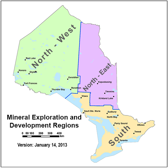
Appendix 1 — map of mineral exploration and development office regions
Appendix 2 — map submission requirements for permit applications
Map submission requirements for plan and permit applications
Map scale, size and format requirements
- The regional map must be between 1:50,000 and 1:250,000 scale. More than one map may be required depending on the location of the project with relation to landmarks.
- The project-scale map must be at a scale where all proposed activities can be seen, generally between 1:5,000 and 1:50,000. Multiple project-scale maps may be necessary to clearly show locations of all proposed activities, and where multiple maps are to be used, an index map showing the boundaries of the various project scale maps will be required.
- The combined size of the application and all attachments including maps must not exceed 10 MB.
- Map submissions must be in pdf format, as only pdfs are accepted in MLAS. Shape files may be requested by Aboriginal communities for their use to overlay on maps. Proponents are encouraged to provide these upon request to facilitate the consultation efforts. We cannot create shape files on behalf of early exploration proponents.
Minimum information requirements for maps
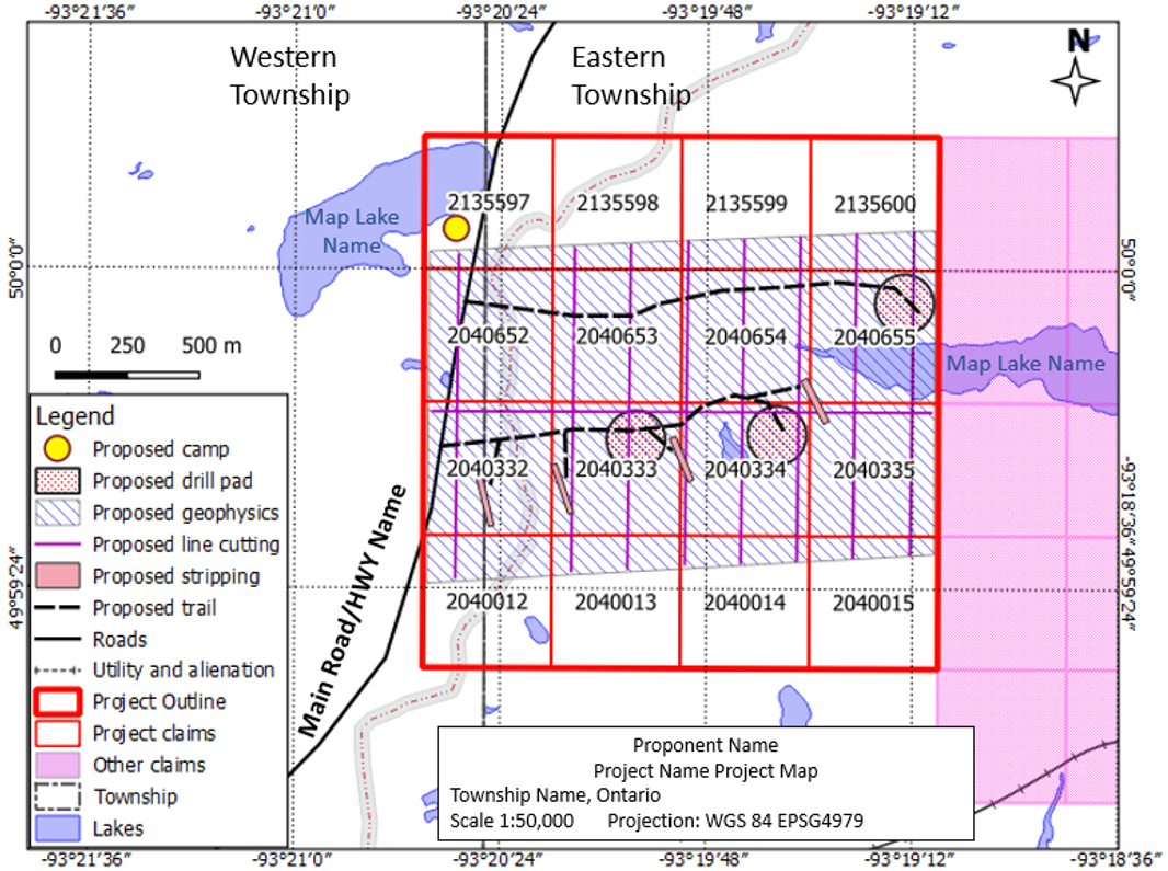
- The regional map(s) should clearly depict where in the province the project is located and include locally identifiable features such as towns, cities, and Aboriginal community locations, including any additional reserve lands. The map should also include and label major highways, roads, provincial parks, and bodies of water.
- The location of the proposed early exploration activities must be defined on the project-scale map(s). Proponents have 2 alternatives in depicting locations:
- they can be identified as points on the project-scale map, with a 200 metres radius buffer clearly identified
- polygons can be provided, with activities to occur within those areas. If this alternative is chosen, the activities must occur within the area of the polygon on the map — no buffers are permitted. Where the proposed activity is drilling, proponents are limited to one drill pad per polygon
- Only include cells on which no prescribed activities will occur in the application if the inclusion of the cell or area serves to link other contiguous cells or areas where exploration activity from the same work program is proposed.
- Additional information that is available, such as existing roads or trails.
- Proposed activities indicated on the map must correspond with the activities, in number and size (area), indicated on the application and the ADR. Regional scale map(s), project-scale map(s) and the ADR will be included with the permit, if issued.
- Please see below for an example of an acceptable project-scale map.
- Maps must also include:
- First Nation reserve lands, if any
- a clear legend
- a graphic or bar scale
- a north arrow
- labels for:
- lakes
- rivers
- other notable topographic features
- railways
- roads (including named logging roads)
- trails
- power lines
- pipelines
- buildings
- boundaries for:
- townships (where applicable)
- mining claims, leases, mining licence of occupation or patent (all mineral tenure must be labelled)
- Surface Rights Owners
- alienations
- withdrawals
- grid coordinates established for reference purposes in latitude - longitude, preferably using deg/min/sec.
- a legend must be used to depict the use of all symbols and/or polygons on the map
- proper and thorough labelling of the maps, including proponent name, project name and a date
Tips
- Be as specific and detailed with the information provided in the maps to clearly identify the locations where the activities will be undertaken, and the scale of work proposed, as this will allow us, Aboriginal communities, Surface Rights Owners and the public to best understand the locations and activities proposed. Sufficient detail is required to enable the determination of potential impacts. An application that does not provide sufficient detail may be returned for revision.
- The MLAS Map Viewer and the associated grid contained within can now be used to produce project and regional-scale maps. This application enables a proponent to add polylines, polygons, and point symbols to maps which can be used to represent proposed prescribed activities and other important details such as proposed roads, trails and exploration camps. The application will also identify any alienations or withdrawals in the area of the proposed project. Users are directed to the MLAS Help Page which has info on drafting maps.
- Geographic coordinates can be obtained from the online MLAS map viewer by clicking on the XY icon at the bottom left of the map screen. This will allow the user to change between coordinate systems (for example, UTM to latitude - longitude).
- Ensure that the ADR matches the project-scale maps. For example, if the ADR indicates 5 separate areas where stripping will occur, and a project-scale map shows fewer than 5, or more than 5, then the application will be returned to the applicant for revision.
- Note, as well, that if the trace of the drill hole is expected to cross over into (under) another cell, that cell must be included in the permit application.
- If a point is used to identify the location of an activity, without showing the buffer, the activity is restricted to that location.
- Note that MLAS does not currently allow for permits to be amended once issued. A proponent will instead need to submit a new application for the Director to consider an amendment or renewal if additional activities are contemplated. If the amendment is administrative in nature, please contact the Mineral Exploration and Development Consultant named in the letter accompanying the issued permit.
- We recommend that proponents submit their exploration permit application, together with all supporting materials including maps that comply with these standards, well ahead of the proposed start date for the project. These materials will aid us in meeting its duty to consult with Aboriginal communities, where it arises, and in complying with its requirements under the Environmental Bill of Rights.
- The application should be restricted to only those claims on which work is proposed including consideration of the allowable flexibilities in activity locations, and contiguity, for assessment purposes.
- No work is permitted outside of what is described in the ADR and shown on the maps. The maps and ADR will be included with a permit, should it be issued.
- Where possible, showing proposed exploration trails on the maps is encouraged as this information aids us in our consultations with potentially affected communities.
- If a camp is mentioned in the ADR, its location must be identified on the project-scale maps.
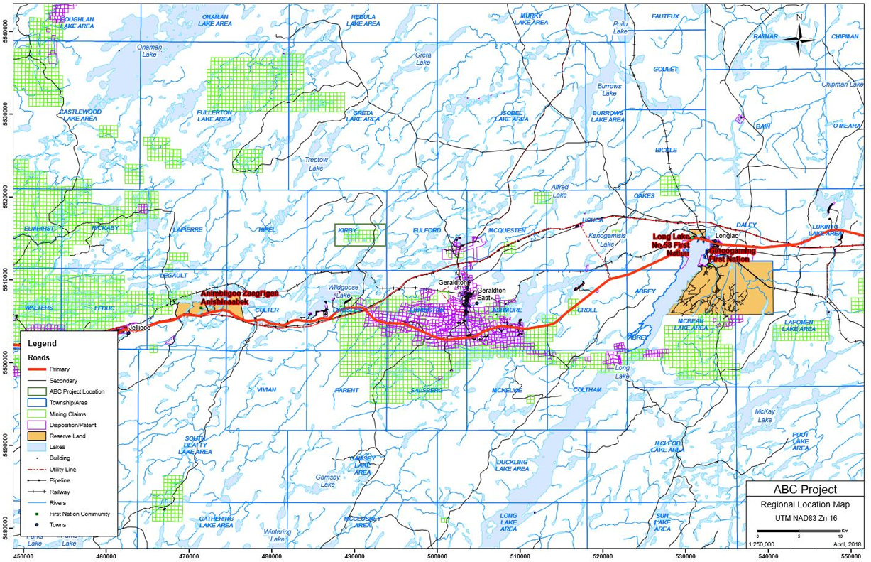
Example of a regional map
Example A
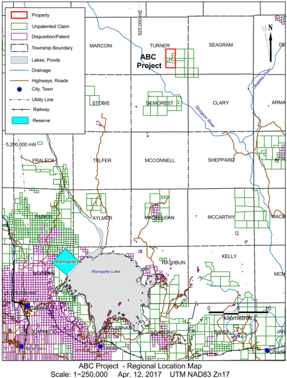
Example B
Example of a project scale map
Example A
Appendix 3 — definitions
Section numbers for Ontario Regulation 308/12 unless otherwise indicated.
“circulation date” means:
- (a) the date on which a Director sends, by whatever means, an exploration plan or an application for an exploration permit to an Aboriginal community that the Director has identified for the purposes of section 7 or 14, or
- (b) if the Director has not identified any Aboriginal communities for the purposes of section 7 or 14, the date on which the Director sends, by whatever means, a notice to the early exploration proponent that the exploration plan or exploration permit application has been received and meets the requirements of this Regulation;
“Director” means a Director of Exploration appointed under section 78 of the Mining Act.
“early exploration” means prospecting and mineral exploration, including those activities that fall within section 1 of Schedule 2 and section 1 of Schedule 3 but not including the activities of advanced exploration or mine production as they are defined in Part VII of the Mining Act.
“early exploration proponent” means a person who is a holder of a mining claim, mining lease, licence of occupation, for mining purposes and is conducting or proposes to conduct early exploration activities and includes:
- directors, officers, agents and employees of the early exploration proponent
- partners, subsidiaries and affiliates of the early exploration proponent
- contractors and subcontractors of the early exploration proponent
- successors and assignees of the early exploration proponent
“Provincial Standards for Early Exploration” means the current version of the document entitled Provincial Standards for Early Exploration (PDF) published by the ministry.
“qualified supervisor” means an individual who has successfully completed the prescribed Prospector's Awareness program not more than 5 years before the proposed start of the early exploration activities and who provides advice to the early exploration proponent regarding any proposed early exploration activity.
These definitions are provided for convenience. You should refer to and rely upon the official definitions contained in Ontario Regulation 308/12 or the Mining Act, as applicable, which will govern if there are any differences in wording from the versions provided here.
Appendix 4 — other regulatory considerations
You should ensure all other legislation and considerations apart from our regulations are followed.
- Crown land work permits are required for various work types on Crown land and shore lands, such as for road construction, water crossings, construction of buildings, cutting timber, and other activities.
- The local ministry office will post when public forest access roads are closed or accessible, and note that private forest access roads may not be accessible unless under term and conditions of an agreement with the land holder.
- For setting up a tent camp near or on the project area, follow the camping on crown land guidelines. If setting up a temporary camp with buildings a work permit may be needed. Review guidelines for fire restrictions. The following regulations and legislation regarding endangered species or species at risk may apply to a project area.
- The natural heritage map application shows environmental and natural values that are to be considered when planning a project.
- Blasting explosives are regulated by Natural Resources Canada and requires a permit for the purchase of blasting explosives. If the explosives quantities exceed 75 kilograms a magazine license is required to store the explosives.
- There are extensive health and safety requirements for personnel working in bush or exploration camps, refer to Occupational Health and Safety Act requirements. For working in the bush there are guidelines published by Workplace Safety North. The Prospectors and Developers Association of Canada (PDAC) provides a Health and Safety in Exploration Toolkit which offers excellent advice on general safety principles, emergency response, survival and much more.
- If a project is close to an inactive or abandoned mine site you may need to contact the Ministry of Labour, Immigration, Training and Skills Development for safety precautions. The Abandoned Mines Information System can be used to determine the location of known mining hazards near your project. Note that it is an offence under the Mining Act to alter, destroy, remove, or impair rehabilitation work, unless you have the consent of the minister. If exploring on a site where rehabilitation has been done, our consent is required prior to any work that may alter, destroy, remove or impair any rehabilitation work that has been completed.
- Some projects may be within municipal boundaries, and subject to their bylaws; contact the local municipality, to confirm that an exploration property is zoned for mining. The Ministry of Municipal Affairs and Housing has developed a provincial policy statement (PDF) which provides policy direction on matters of provincial interest related to land use planning and development.
- Proposed work which will be undertaken in a navigable waterway must receive approvals from Transport Canada prior to its construction and is guided by the Canadian Navigable Waters Act Navigable Water Works Regulations.
- Prior to performing diamond drilling the Ministry of Labour, Immigration, Training and Skills Development must be contacted regarding workplace safety and health standards that must be met, and will require a Notice of Operation of a Test Drill.
- Ontario Water Resources Act water well regulations may apply to a project and may need a permit to take water.
- Consider the Principles and Guidance Notes set out in the Prospectors and Developers Association of Canada’s (PDAC) Driving Responsible Exploration (DRE) Driving Responsible Exploration (DRE). Use the PDAC toolkits to ensure an exploration program is governed according to the following three major issues of today:
- social responsibility
- excellence in environmental stewardship (PDF)
- following current Health and Safety in Exploration Toolkits
- All prescribed exploration activities must be carried out and rehabilitated as per the Provincial Standards for Early Exploration (PDF).