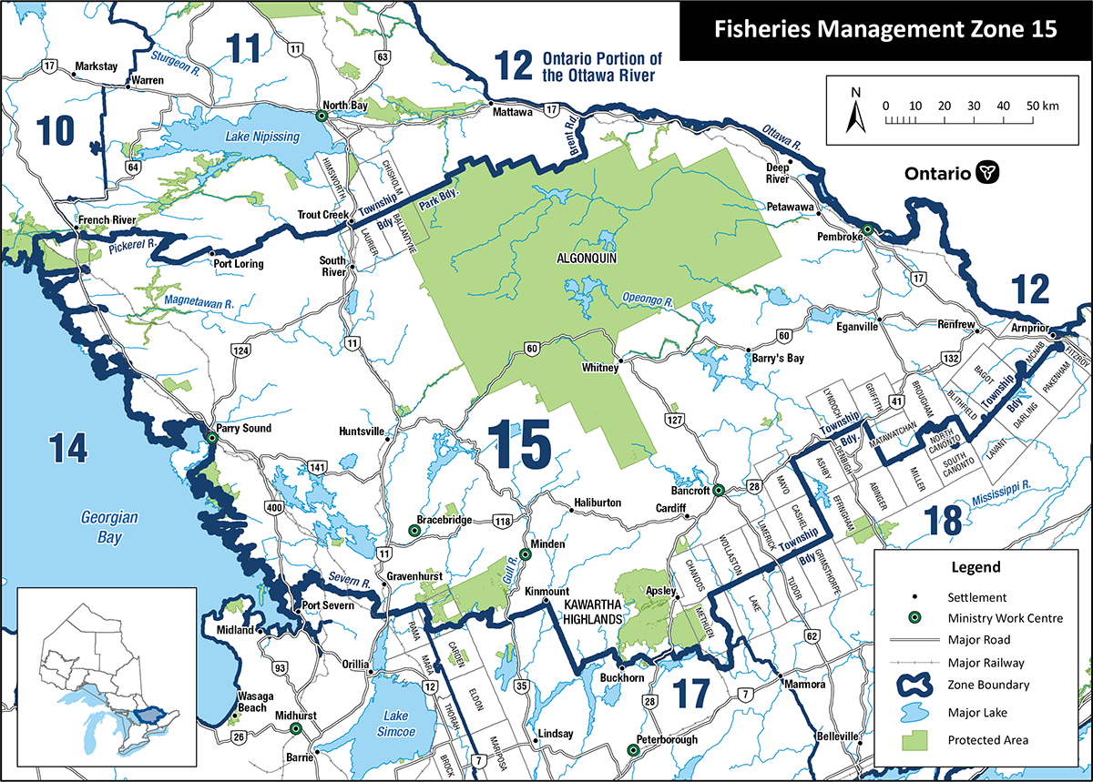
Fisheries Management Zone 15 (FMZ 15)
Information about fishing and how fish resources are managed in Fisheries Management Zone 15 (Parry Sound, Bancroft, Pembroke, Algonquin Park).
News and updates
FMZ 15 management plan update 2022
The management plan for FMZ 15 is intended to outline the status of the fisheries in the zone, describe management objectives and provide direction for management actions. We are proposing some changes to fishing regulations in this zone through the planning process such as:
- improving brook trout, lake trout, lake whitefish and walleye sustainability, by:
- reducing brook trout catch limit
- changing lake trout season and size
- reducing lake whitefish catch limit
- providing more opportunities for smallmouth and largemouth bass fishing
The Environmental Registry of Ontario comment period for the draft management plan for FMZ 15 ended on November 28, 2022.
All comments and feedback received are being reviewed and considered. When complete, the final plan will be posted on the Environmental Registry of Ontario.
You can read more about these proposed changes on the Environmental Registry of Ontario.
Fishing rules
You can:
- find specific rules for fishing in FMZ 15
- use the Fish on-Line mapping tool
- find a complete set of fishing rules in the Ontario Fishing Regulations Summary
About this zone
FMZ 15 is located in central Ontario. This large zone has:
- many natural lake and brook trout lakes
- a well-developed road network and moderate angling effort
- Algonquin Provincial Park
- lake and brook trout stocking to increase angling opportunities
- important recreational fisheries for lake and brook trout, walleye, northern pike, smallmouth bass
FMZ 15 is one of 20 fisheries management zones in the province.
Location
FMZ 15:
- extends from Georgian Bay in the west to the Ottawa River in the east
- its northern boundary follows the Pickerel River, Highway 522 and the northern edge of Algonquin Park
- cities include Parry Sound, Gravenhurst, Bracebridge, Huntsville, Minden, Haliburton, Whitney, Bancroft, Deep River, Petawawa, Pembroke and Renfrew
Legal boundary map and detail maps
Legal boundary map for FMZ 15 and detail maps 1 - 32.1 (PDF)
Monitoring reports and management plans
None available at this time.
Zone advisory council
There is currently an advisory council. For more information on how you can get involved in fisheries management, contact your local work centre.
General fishing rules
- Open fishing seasons and fish sanctuaries
- Fishing limits, size restrictions and catch and release
- Sustainable bait management in Ontario
Dip net for lake whitefish and lake herring in Parry Sound, Bancroft, Pembroke or Algonquin Park (fisheries management zone 15)?
You can dip net for lake whitefish and lake herring only in these designated waters:
- Aylen Lake (45°37'N., 77°51'W.) – Dickens Township
- Bonnechere River (45°37'22"N., 77°27'08"W.) – North Algona, Fraser and Hagarty Townships, between the Tramore Bridge and Golden Lake
- Bonnechere River (Richards Township) – between Jacks Chute and Round Lake
- Boshkung Lake (45°04'N., 78°44'W.) – Stanhope Township
- Canning Lake (44°56’27”N., 78°38’50”W.) – Minden and Snowden Townships
- Carson Lake - (45°30'50"N., 77°45'31"W.) – Jones and Sherwood Townships
- Dam Lake (45°25'18"N., 77°32'22"W.) – Radcliffe Township
- Diamond Lake (45°22'07"N., 77°32'13"W.) – Radcliffe Township
- Golden Lake (45°33'56"N., 77°19'29"W.) – North and South Algona Townships
- Greenan (Kulas) Lake (45°28'16"N., 77°44'03"W.) – Jones and Sherwood Townships
- Halfway Lake (45°24'43"N., 77°35'52"W.) – Radcliffe Township
- Narrows between Legrou and Chartier Lake (45°50’55”N., 79°53’00”W.) – Mills Township
- Oblong Lake (45°10’46”N., 78°25’58”W.) – Harburn Township
- Raglan (White) Lake (45°16'21"N., 77°30'42"W.) – Raglan Township
- Trout (Stubbs) Lake (45°29'31"N., 77°44'36"W.) – Jones and Sherwood Township
- Twelve Mile Lake (45°01’31"N., 78°42'22"W.) – Minden Township
- Victoria Lake (45°37'N., 78°01'W.) – Murchison and Clancy Townships
- Wadsworth Lake (45°26'22"N., 77°34'48"W.) – Radcliffe Township
