Forest fires
Information about the current forest fire danger, forest fire activity and fire restrictions across the province.
Report a fire
 To report a forest fire call
 South of the French and Mattawa rivers please call 911.

Interactive fire map
Real time updates.
Our interactive map visually shows active fires, current fire danger across the province and restricted fire zones in effect.
The map now shows perimeters for some fires over 40 hectares in size. Please note that not all fires are mapped and perimeters are not updated every day (may differ from the size reported in the table).
We recommend using Google chrome as your web browser to access the map.
Ontario's fire season starts April 1.
Aviation, Forest Fire and Emergency Services would like to remind the public that during Ontario’s legislated fire season (from April 1 to October 31), Ontario’s Outdoor Burning Regulations are in effect. In order to dispose of yard waste and woody debris, we encourage you to use methods such as composting or using your local landfill. If you must burn, use caution and follow Ontario’s Outdoor Burning Regulations.
Fires are to be ignited no sooner than 2 hours before sunset and extinguished no later than 2 hours after sunrise. Always have tools/water adequate to contain the fire at the site. Know the rules for safe outdoor burning. Read the full set of Outdoor Burning Regulations.
Residents within municipal boundaries must also check with their local fire department for burning restrictions or permitting requirements prior to burning.
Forest fire updates
Northwest Region
Updated: May 20, 2025 - 7:30 p.m. CST
Fires of note:
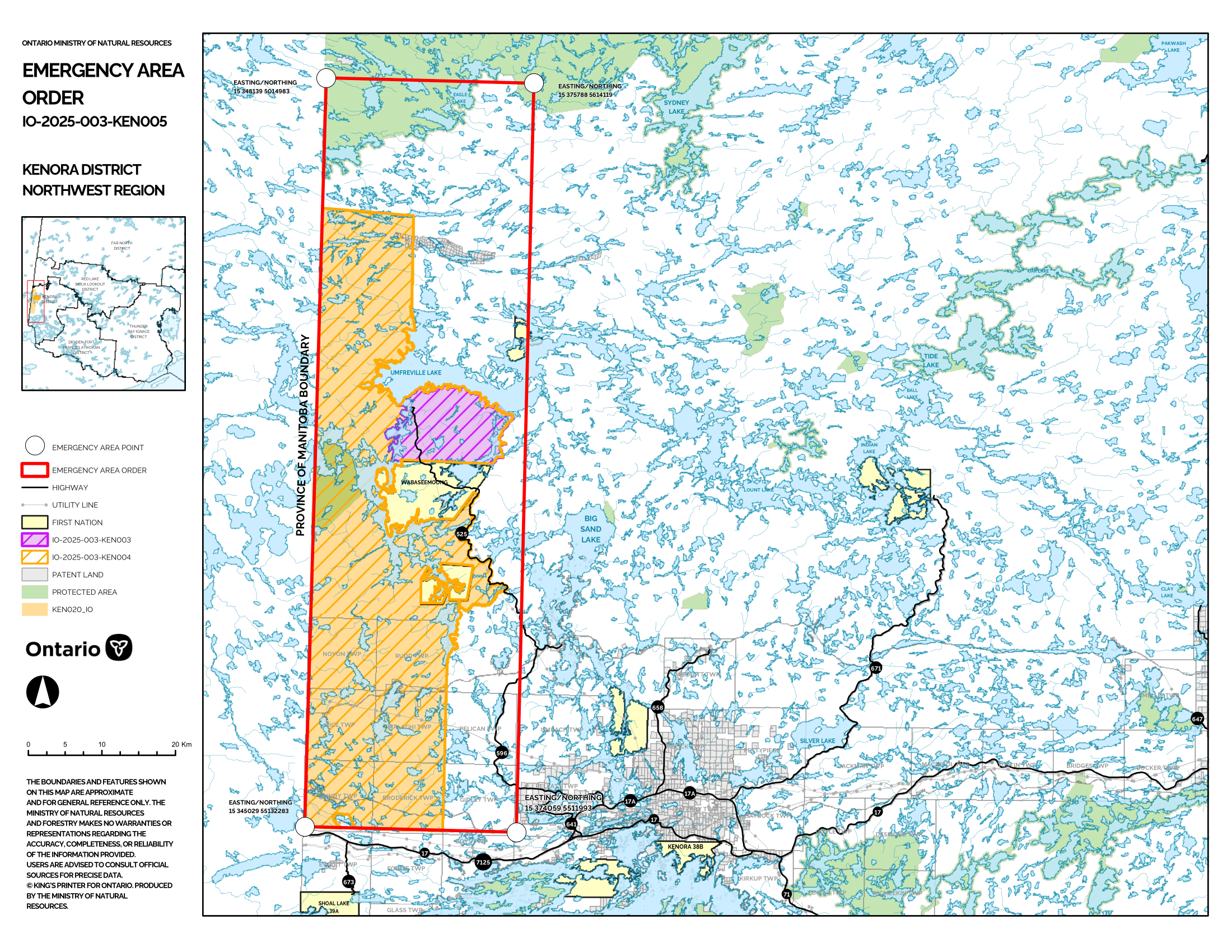
Kenora 20 (KEN 020)
- Kenora 20 was remapped at 31,276 hectares and is not under control.
- Rising temperatures, steady winds from the east and low relative humidity saw increasing fire behaviour on Kenora 20 as a drying trend continues.
- Firefighting personnel from Ontario and British Columbia are working on Kenora 20 and Kenora 14, with crews establishing hose lines, cutting helipads, and establishing values protection around communities.
- Heavy helicopters continue to action hot spots.
- Infrared scanning is being used to locate hotspots and identify priority areas.
Restrictions in effect - Kenora 20
Aviation, Forest Fire and Emergency Services has been advised that as recommended by the Ministry of Natural resources’ Kenora District, an Implementation Order is now in effect for the purposes of public safety and/or effectual fire suppression, for areas near Kenora 20 Under the Emergency Area Order EAO 2025-03 declared on May 13, 2025.
- All travel and use of roads, including Gundy Road north of Tannis Lake, Pickerel Lake Road beyond the Pelicanpouch access point at km 9, and Cygnet Lake Road, is prohibited unless authorized by a travel permit.
- All use of lakes and waterways within the Area including the Winnipeg River below Whitedog Falls (UTM 15U 366399 5553102), Eaglenest Lake, Tetu Lake, Cygnet Lake, Rice Lake, Malachi Lake, Otter Lake, Macara lake, Longpine Lake, and Dagimabrop Lake is prohibited.
- All use and occupation of Crown Land, within the hatched area identified on the attached Implementation Order map (Schedule A), is prohibited.
Evacuation Order of area
- All persons must immediately evacuate the area indicated on the attached map unless authorized by a travel permit issued by the Ministry of Natural Resources.
- All persons are prohibited from entering the area indicated on the attached map unless authorized by a travel permit issued by the Ministry of Natural Resources.
Review the Implementation Order Map here.
This Order is in effect at 6:01 p.m. Central Daylight Time on May 13, 2025 until such time as the order is revoked.
Requests for travel permits can be directed to Michelle Riley, Kenora District Office of the Ministry of Natural resources at
Kenora 14 (KEN 014)
- Kenora 14 is sized at 1,607 hectares. The fire’s control status is not under control.
- Crews made significant progress establishing hoseline on the eastern perimeter of the Kenora 14 today.
Restrictions in effect - Kenora 14
Aviation, Forest Fire and Emergency Services has been advised that as recommended by the Ministry of Natural resources’ Kenora District, an Implementation Order is now in effect for the purposes of public safety and/or effectual fire suppression, for areas near Kenora 14 Under the Emergency Area Order EAO 2025-03 declared on May 13, 2025.
- All travel and use of roads, including Highway 525 at and beyond the northern boundary of Wabaseemoong First Nation, is prohibited unless authorized by a travel permit.
- All use of lakes and waterways within the English River system between Tetu Lake (UTM 15U 356895 5562897) and Umfreville Lake (UTM 358379 5570917) is prohibited.
- All use of lakes and waterways between Goshawk Lake (UTM 15U 371012 5562576) and Umfreville Lake (UTM 3712722 5570758) is prohibited.
- All use and occupation of Crown Land, within the hatched area identified on the attached Implementation Order map (Schedule A), is prohibited.
Review the Implementation Order Map here.
This Order is in effect at 6:01 p.m. Central Daylight Time on May 13, 2025 until such time as the order is revoked.
Requests for travel permits can be directed to Michelle Riley, Kenora District Office of the Ministry of Natural resources at
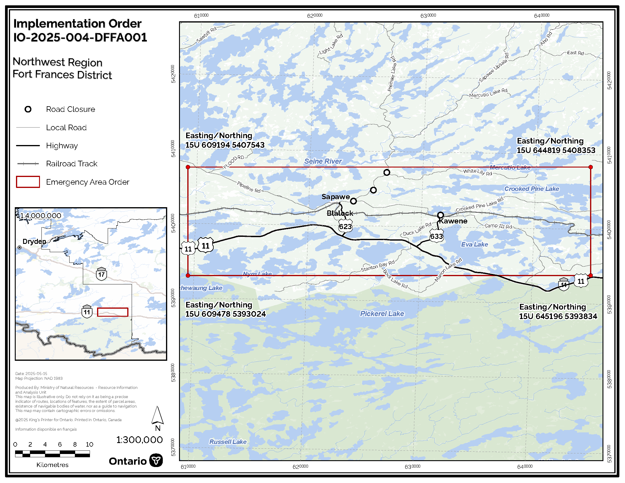
Fort Frances 4 (FOR 004)
- Fort Frances 4 remains at approximately 3,593 hectares in size.
- There has been no growth and minimal fire behaviour observed on the fire for several days.
- FireRanger crews continue to focus on finding and extinguishing hotspots.
Evacuation Alert lifted
Following a recommendation from the Ministry of Natural Resources’ Dryden Fort Frances Atikokan District, the evacuation alert issued on May 14, 2025 for areas near wildland fire Fort Frances 4 (FOR004) has been lifted.
Residents, cottagers, and visitors are urged to remain cautious and stay prepared as fire conditions can change.
Please continue to:
- Keep your emergency kit ready in case conditions change
- Follow directions from local officials and respect any road or area closures
- Allow space for fire crews and aircraft to operate safely
Restrictions in effect - Fort Frances 4
Aviation, Forest Fire and Emergency Services has been advised that as recommended by the Ministry of Natural Resources’ Dryden Fort Frances Atikokan District, an Implementation Order is now in effect for the purposes of public safety and/or effectual fire suppression, for areas near Fort Frances 4 Under the Emergency Area Order EAO 2025-04 declared on May 13, 2025.
- All travel and use of Crooked Pine Road, from Sapawe Road to Camp 111 Road Junction, is prohibited unless authorized by a travel permit issued by the Dryden Fort Frances Atikokan District of the Ministry of Natural Resources.
- All travel and use of Bjorkman Road accessing Whiskyjack Lake off Sapawe Road Junction, is prohibited unless authorized by a travel permit issued by the Dryden Fort Frances Atikokan District of the Ministry of Natural Resources.
- All travel and use of White Lily Road at the Sapawe Road Junction is prohibited unless authorized by a travel permit issued by the Dryden Fort Frances Atikokan District of the Ministry of Natural Resources.
- All use of lakes and waterways accessible from the Atikokan River system between the outflow of Crooked Pine Lake to the bridge where the Atikokan River crosses the Sapawe Road is prohibited.
- All persons are prohibited from traveling down the identified closed roads unless authorized by a travel permit issued by the Ministry of Natural Resources that are located within the identified area
This Order is in effect at 1:00 p.m. Central Daylight Time on May 15th, 2025 until such time as the order is revoked.
For travel permit information, please contact Laura Pfeifer at
Review the Implementation Order Map here.
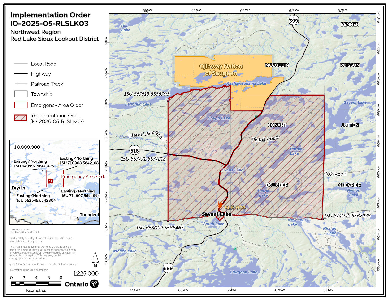
Sioux Lookout 3 (SLK 003)
- Sioux Lookout 3 remains at approximately 1,849 hectares in size.
- FireRanger crews continue to establish hose lines with suppression efforts supported by heavy equipment.
- Infrared scanning is planned to assist in identifying priority areas.
- Pilots are reminded that, in accordance with Transport Canada regulations, NOTAMs are in effect over all active forest fires.
- The Implementation Order for areas around the fire has been revised. See details below.
Restrictions in effect - Sioux Lookout 3
Aviation, Forest Fire and Emergency Services has been advised that as recommended by the Ministry of Natural Resources’ Red Lake Sioux Lookout District, an Implementation Order is now in effect for the purposes of public safety and/or effectual fire suppression, for areas near Sioux Lookout 3 (SLK003) Under the Emergency Area Order EAO 2025-05 declared on May 14, 2025.
- Unless authorized by a travel permit issued by the Red Lake Sioux Lookout District office of the Ministry of Natural Resources (MNR), no person shall enter the hatched area (excluding provincial highway 599 and 516) identified on the attached Implementation Order map (Schedule A IO-2025-05-RLSLK03), and all persons must immediately evacuate said area.
- Travel and use of forest access roads, as well as access to lakes, waterways and Crown land at the CN railway at UTM 15U 658092 5566465, north to Island Lake Road at HWY 516 (15U 657772 5577218), north to 15U 657513 5585798, along the southern shore of Kashaweogama Lake including Conant Township and Boucher Township, south to CN railway, and the unorganized township of Savant Lake community as outlined in the hatched area on the attached Implementation Order map (IO-2025-05-RLSLK03 - Schedule A), are prohibited unless authorized by a travel permit.
- All modes of travel and use of forest access roads including 702, East Island Lake, Browning, and Pintail roads is prohibited unless authorized by a travel permit.
See Implementation Order map here.
This order is in effect as of hours 00:01 AM CST on May 19, 2025, and will remain in place until such time as the order is revoked.
Requests for travel permits can be directed to the Red Lake Sioux Lookout District Office of the Ministry of Natural resources at
New fires
At the time of this update there are 10 active fires in the Northwest Region. Of those fires, 2 are under control, 1 is being observed and 7 are not under control.
There were three new fires confirmed in the Northwest Region by the evening of May 20.
- Dryden 7 (DRY007) is located near the eastern shore of Sandal Lake, and approximately 2 kilometres north of highway 17. CL415 waterbombers and birddog aircraft are on scene. This fire 1.5 hectare fire is not under control.
- Thunder Bay 7 (THU007) is a 0.1 hectare fire located 3 kilometers west of Kabitotikwia River Provincial Park and is not under control.
- Thunder Bay 8 (THU008) is located approximately 8 kilometers north of the East Firesteel River, near Muriel Lake. This 0.8 hectare fire is not under control.
The wildland fire hazard is ranges from low to moderate on the eastern side of the Region. The western half is observing a high to extreme hazard, with areas of high hazard developing in the Red Lake and Kenora fire management sectors. Despite recent precipitation and cooler temperatures, forested areas remain extremely dry.
For a closer look at fire hazard conditions in your area, review our Interactive Map.
Northeast Region
Updated: May 20, 2025 - 5:20 p.m. EST
There were 3 new wildland fires confirmed in the Northeast Region today.
- Sudbury 10 (SUD009) was a 0.1 hectare fire located in Grundy Lake Provincial Park, around a kilometre east of Gurd Lake. The fire is out.
- Sudbury 11 (SUD010) was a 0.1 hectare fire located on the west side of Maple Lake. The fire is out.
- Timmins 2 (TIM002) is a 0.1 hectare fire located on an island on the north end of Currie Lake. The fire is not under control.
There are 3 active wildland fire in the Northeast Region. One is not under control, and 2 are under control.
The fire hazard is primarily low to moderate across the Northeast Region this afternoon. The following areas have a high hazard: Chapleau, Kirkland Lake, Englehart, and from Markstay-Warren south to Parry Sound.
For a closer look at fire hazard conditions in your area, see our Interactive Map.
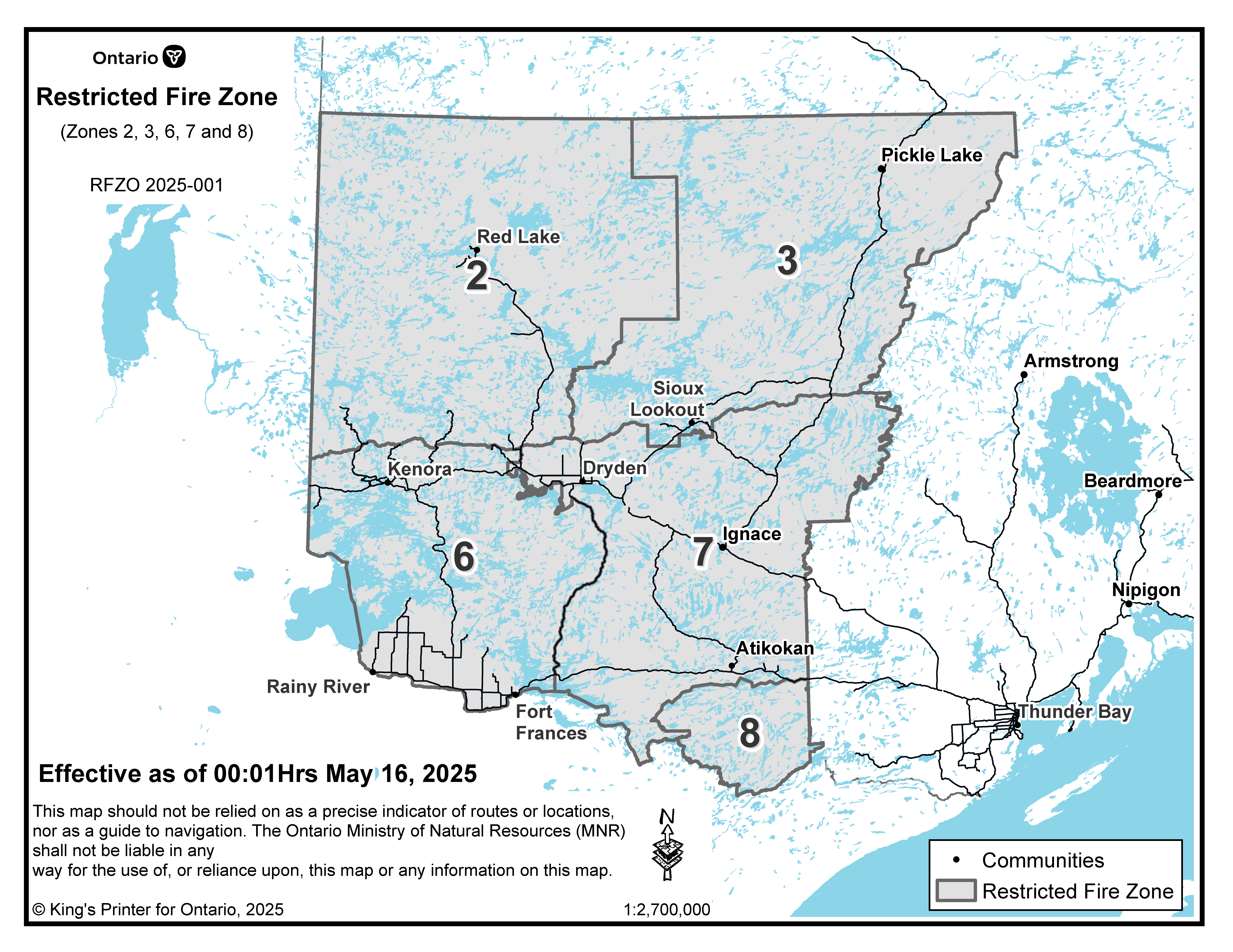
Restricted fire zones
Due to the extreme forest fire hazard conditions and to reduce the number of human-caused fires, the Ministry of Natural Resources has declared a Restricted Fire Zone effective Friday, May 16 at 12:01 am local time for a portion of the Northwest Region (Zones 2, 3, 6, 7, 8).
The area impacted will be from the Southwest corner of the USA, Manitoba and Ontario border, North along the Manitoba border to West of the midway point of Weeskayjahk Ohtahzhoganeeng Provincial Park, East to North of Wabakimi Provincial Park, South along the Western border of Wabakimi Provincial Park to the Eastern border of Quetico Provincial Park until the USA border, then back West along the USA/Canada border to the Manitoba Borde
No open air burning, including campfires, is permitted within the boundaries of a Restricted Fire Zone. Portable gas or propane stoves may be used for cooking and warmth but must be handled with extreme caution. All burning permits are suspended. The Restricted Fire Zone is in place until further notice.
Review Restricted Fire Zone Map here
Contact information
Northeast Region
Isabelle Chenard
Fire Information Officer
Evan Lizotte
Fire Information Officer
Northwest Region
Alison Lake
Fire Information Officer
Social media
Check out our Facebook, Instagram and X (formerly Twitter) accounts for safety tips and other forest fire related information.
For highway conditions, including road closures:
For air quality in your area, please visit:
public weather alerts for Canada
For smoke drift conditions across North America, visit:
smoke drift across North America
For information about forest fire smoke and your health, consult:
smoke and your health
Fires: year to date
The figures below represent the year-to-date total number of forest fires inside Ontario’s fire region for the 2025 fire season, as they compare to the 2024 season and to the 10-year average.
- 79fires in 2025
- 65fires in 2024
- 9110-year average
Fire bans in provincial parks
For all park fire bans see:
Ontario parks alerts
You are responsible for fires you light
From April through October, people using outdoor fires must follow strict guidelines under the Forest Fires Prevention Act of Ontario to ensure their fires are properly managed.
Anyone who starts a fire outdoors must take all necessary steps to tend the fire, keep it under control, and make sure the fire is out before leaving the site. A person failing to burn safely could be fined and held responsible for the cost of putting out the fire. People living in municipalities should check with local fire officials for bylaws on outdoor fires.
Hunters
- check the interactive fire map to find out where the active wildland fires are in Ontario.
- be aware of FireRangers who may be working in forested areas.
- check your surroundings for FireRanger activity before discharging your firearm to help keep everyone safe.
About Aviation, Forest Fire and Emergency Services (AFFES)
Visit our forest, wildland and outdoor fires page for more information on AFFES and wildland fire management, including: